2.1 INTRODUCTION 2.2 BACKGROUND
|
|
|
- Egbert Caldwell
- 5 years ago
- Views:
Transcription
1 Chapter 2: Project Alternatives 2.1 INTRODUCTION Two alternatives are evaluated in the 68th Street/Hunter College Subway Station Improvement Project EA. This chapter describes the alternatives considered for the project and provides the planning background for the development of the alternatives. Section 2.2 describes the background and planning of the project, the evolution of different alternatives, public outreach and input, and an overview of preliminary alternatives considered. The No Build Alternative is illustrated in Figure 2-1, and the preliminary alternatives evaluated are illustrated in the following pages. Additional information on the preliminary alternatives and their evaluation with regard to the purpose and need and goals and objectives is provided in Table S-1, above and in Appendix A. Preliminary alternatives that did not meet the purpose and need or did not sufficiently meet the goals and objectives were eliminated from further consideration. A summary of the alternatives evaluation is provided as Table A-2 in Appendix A. 2.2 BACKGROUND MTA NYCT undertook a conceptual design effort to provide ADA accessibility to the station (ADA accessibility necessarily involves vertical circulation between the platform level, the mezzanine, and the street level for those who cannot use stairs) and to address the circulation deficiencies at the 68th Street/Hunter College Station. This initial effort resulted in the development of the Mezzanine Expansion Alternative (Alternative 1, Figure 2-2). Further study of this preliminary alternative revealed unforeseen construction and engineering challenges and risks associated with the plan, which called for expanding the mezzanine north over the tracks and constructing additional platform stairs to the expanded mezzanine at East 68th Street. In addition to numerous disruptions in subway service (due to work at the track level), the plan would have required costly relocation of communication infrastructure, and the underpinning of adjacent historic structures (Thomas Hunter Hall and the Imperial House Apartments). A second alternative (Alternative 2 Northern Access, Figure 2-3) was therefore developed by MTA NYCT to address these concerns. Alternative 2 Northern Access would provide new platform stairs and street stairs at East 69th Street, near the north end of the station, thereby avoiding the need to expand the existing mezzanine and construct new platform stairs to the expanded mezzanine at East 68th Street. By eliminating the need to construct additional platform stairs feeding into the mezzanine and the need to substantially enlarge the mezzanine at East 68th Street, Alternative 2 Northern Access would avoid or minimize the risks associated with relocating communication/data infrastructure and would not require the underpinning of Thomas Hunter Hall. It would reduce construction impacts and require far fewer subway service outages when compared with Alternative 1. MTA NYCT subsequently studied the transportation performance of the two alternatives in greater detail (Appendix C) and determined that Alternative 2 Northern Access would perform better than Alternative 1. As a result, MTA NYCT decided to advance Alternative 2 Northern Access. 2-1
2
3
4
5 Chapter 2: Project Alternatives MTA NYCT then conducted a series of public meetings to inform residents and businesses surrounding the 68th Street/Hunter College Station of the planned improvements to the station (see Chapter 14). During these meetings, members of the community proposed other alternatives that did not include street entrances on East 69th Street. These alternatives suggested by public comments included new street entrances at East 67th Street (Alternative 3, Figure 2-4), new entrances at East 70th street (Alternative 4, Figure 2-5), and other proposals identified in Appendix A. MTA NYCT identified a set of criteria to evaluate the ability of each alternative and each street stair option to satisfy the project purpose and need and the project goals and objectives. Criteria focused on ADA compliance for the station; improving circulation on the platform stairs and street stairs; improving the distribution of passenger load on the train and along platform length; passenger convenience and circulation efficiency; and fare control area and mezzanine performance. The criteria included construction phase issues such as minimizing cost and construction risk, construction duration, disruption to station and subway operations and passengers, and construction impacts to the surrounding neighborhood. Other criteria included impacts to historic resources and use of Section 4(f) resources. Using these criteria, Alternatives 3 and 4 were evaluated for their ability to satisfy the project goals and objectives and were eliminated from further consideration (Appendix A). As part of the development of Alternative 2 Northern Access, MTA NYCT explored different options for the location of street entrances at the north end of the station. Options included stair locations on the north and south sidewalks of East 69th Street both east and west of Lexington Avenue, and on the east and west sidewalks of Lexington Avenue both north and south of East 69th Street. As a result of the evaluation of these options (see Appendix A), a configuration of new entrances one for each platform was initially identified that best met the goals and objectives of the proposed project (this configuration is illustrated in Figure 2-3). For the southbound platform, this configuration would consist of a new, small mezzanine under East 69th Street (identified as Option W1 in Appendix A). This mezzanine would connect to the street via a new street stair on the south sidewalk of East 69th Street west of Lexington Avenue; a new platform stair would connect the mezzanine to the platform. For the northbound platform, this configuration would consist of a new platform stair connecting to a new, small mezzanine under East 69th Street and a connecting street stair on the south sidewalk of East 69th Street east of Lexington Avenue (identified as Option E1 in Appendix A). This set of street stair options was presented by MTA NYCT to the community and other interested parties during several meetings conducted to solicit feedback. Some members of the community requested that MTA NYCT explore locating a street-level entrance within one of the retail spaces on the ground floor of a building that occupies the entire block encompassed by Third Avenue, Lexington Avenue, East 68th Street, and East 69th Street, with ground-floor retail fronting Lexington Avenue between the two streets. In an effort to be responsive to community concerns, MTA NYCT entered into discussions with representatives of the building. During these discussions, MTA NYCT was presented with the possible opportunity for locating a street stair in a retail space in the building. This space, located at 931 Lexington Avenue, approximately midway between East 68th Street and East 69th Street, was identified as a viable stair option and MTA NYCT subsequently incorporated this possible location as Option E10 into the mix of Alternative 2 Northern Access stair options. 2-5
6
7
8 68 th Street/Hunter College Subway Station Improvement Project EA In consideration of community concerns, the project purpose and need and project goals and objectives, MTA NYCT then re-evaluated the various Alternative 2 Northern Access street stair options (see Appendix A) and identified the retail space at 931 Lexington Avenue (Option E10) as the preferred location for street access to the northbound platform, and maintained Option W1 on the southwest corner of East 69th Street at Lexington Avenue as the preferred location for street access to the southbound platform. These street stair locations are preferred because they would result in fewer environmental impacts and fewer conflicts with surrounding land uses, are more responsive to community concerns, and/or would be less expensive to construct. Therefore, Alternative 2, now comprising these preferred stair locations (Option E10 and Option W1), is being advanced as the Proposed Project. The Proposed Project is illustrated in Figure 2-6. Street Stair Option W1 is illustrated in Figure 2-7, Street Stair Option E10 is illustrated in Figure 2-8, and Street Stair Option E 1 is illustrated in Figure 2-9. At the time of preparation of this document, the owner of the building identified for locating Option E10 could not yet state with certainty that the commercial space at 931 Lexington Avenue (Option E10) would be available. Pending confirmation of availability of the space at 931 Lexington Avenue, MTA NYCT therefore retained the option for a street stair at the south sidewalk of East 69th Street east of Lexington Avenue (Option E1) as an optional entrance location to the northbound platform. In addition to the Proposed Project (which includes Option E10 at 931 Lexington Avenue) this EA therefore also evaluates the Proposed Project with Option E1. The Proposed Project with Option E1 is identical to the Proposed Project but replaces the 931 Lexington Avenue entrance with a street entrance on the south sidewalk of East 69th Street east of Lexington Avenue (Option E1). 2-8
9
10
11
12
13 Chapter 2: Project Alternatives 2.3 NO-BUILD ALTERNATIVE Under the No-Build Alternative, the Proposed Project would not be advanced. Improvements to the platform stairs and street stairs, ADA elevators and other improvements throughout the station would not be implemented. Without the ADA-compliant elevators, the station would remain inaccessible to some persons with disabilities. Under the No-Build Alternative, MTA NYCT would not meet ADA requirements for all of its designated Key Stations by the year 2020 and would be liable to potential financial penalties. Although congested conditions may improve somewhat by 2020 because of diverted ridership from the Lexington Avenue Line to the Second Avenue Subway, the improvement would be marginal and deficiencies would remain, especially in the AM peak. The existing curb parking lane and sidewalk configuration on East 69th Street would remain unchanged, and the retail space at 931 Lexington Avenue would not contain a subway access stair. Considering the two metrics commonly used to evaluate passenger circulation through New York City subway stations, Tables 2-1 and 2-2 illustrate the station performance in terms of clearance times and LOS, as observed in the existing, and as calculated for the 2020 No-Build condition. Table 2-1: Existing and 2020 No-Build Clearance Times (seconds) Platform Stairs Stair ID Existing Peak Conditions 2020 No-Build Peak Conditions AM PM AM PM P P P P Stair IDs are indicated on Figure Table 2-2: Existing and 2020 No-Build LOS - Street Stairs 2020 Stair ID Existing Peak Conditions No-Build Peak Conditions AM PM AM PM S4 F D E D S3 D B C A O2/O4 F E E D O1/O3 C B B A Stair IDs are indicated on Figure As illustrated in the above tables, station performance marginally improves in 2020 with the operation of the Second Avenue Subway. However, Stairs P2, P3, and P4 continue to perform below MTA NYCT standards in the AM peak, and during the AM peak period, the street stairs located on the east side of Lexington Avenue remain over capacity. 2-13
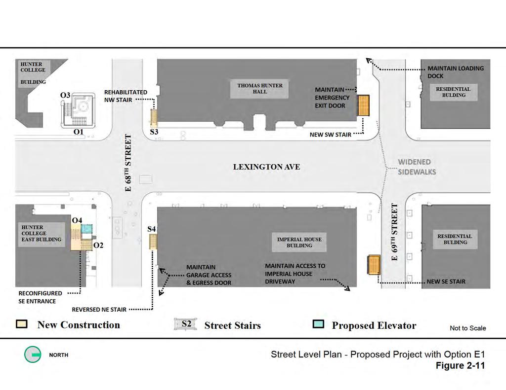
14 68 th Street/Hunter College Subway Station Improvement Project EA 2.4 PROPOSED PROJECT (The discussion below applies to both the Proposed Project and the Proposed Project with Option E1, unless otherwise indicated.) The Proposed Project consists of several improvements to the 68th Street/Hunter College Station. The Proposed Project addresses congestion and circulation problems, which occur on the two levels at this station and the street level above, as well as the need to provide ADA-compliant access between all three levels. An evaluation of vertical access in support of ADA compliance is provided in Section 2.4.3, after this summary of the proposed changes to the station. The station would be reconfigured, resulting in changes at the street level and below street level at the Lexington Avenue intersections of East 68th Street and East 69th Street. The reconfiguration would also result in changes at the station s existing mezzanine level and at the platform level. The proposed improvements can be summarized as follows: Installation of three ADA-compliant elevators and related improvements (see the list at the end of Section 2.4.2) to bring this Key Station into compliance with ADA. Reconstruction and/or relocation of three of the four existing street stairs at the southeast, northeast, and northwest corners of East 68th Street and Lexington Avenue to improve pedestrian circulation on these street stairs and throughout the mezzanine, and to provide necessary space for the ADA-compliant elevator to street level on the southeast corner of the intersection. Installation of a new street stair on the south sidewalk of East 69th Street west of Lexington Avenue. This street stair would connect to a new subway mezzanine and platform stair serving the southbound platform. Installation of a new street stair in a retail space at 931 Lexington Avenue, within the Imperial House apartment building. This street stair would connect to a new subway mezzanine and platform stair serving the northbound platform. Proposed Project with Option E1. If street stair Option E10 is not available, installation of a new street stair on the south sidewalk of East 69th Street east of Lexington Avenue (Proposed Project with Option E1). This street stair would connect to a new subway mezzanine and platform stair serving the northbound platform. An overview is provided below for the improvements at each level STREET LEVEL Figures on the following pages illustrate the changes at street level that would result from the Proposed Project at East 68th Street and East 69th Street. Figure 2-10, Street Level Plan, illustrates the future conditions with the Proposed Project. Figure 2-11, Street Level Plan Option E1, illustrates the future conditions under the Proposed Project with Option E
15
16

17
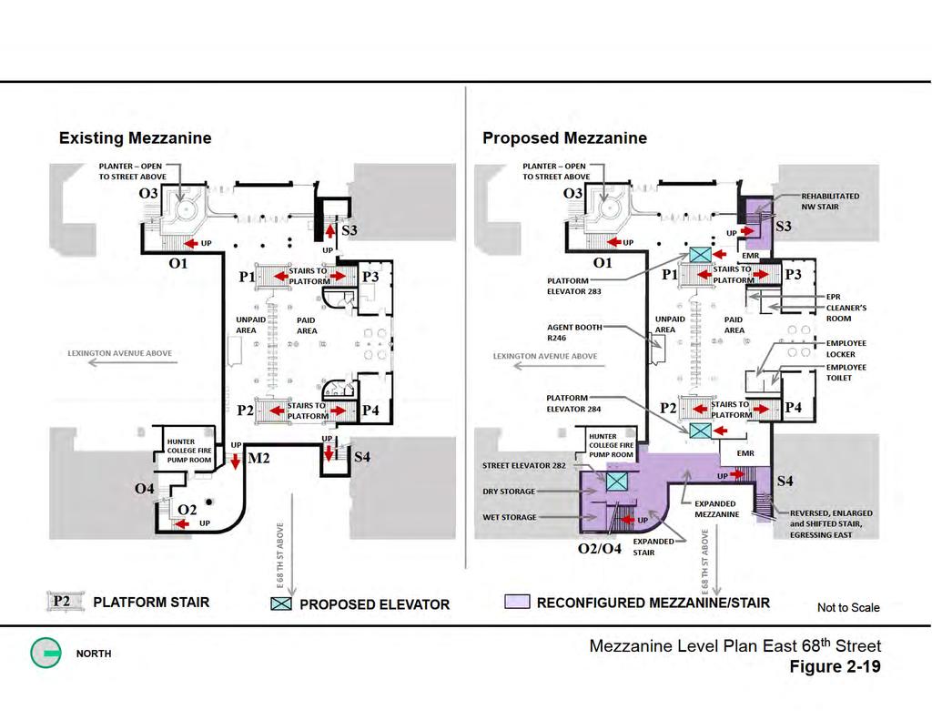
18 68 th Street/Hunter College Subway Station Improvement Project EA East 68th Street New ADA-Compliant Elevator and Improvement of Existing Street Stairs, Proposed Project and Proposed Project with Option E1 Street Stair O2/O4 At street level on East 68th Street, the Proposed Project would increase the width of the stair O2/O4 at the southeast corner of Lexington Avenue and East 68th Street. Street Level ADA-Compliant Elevator An ADA-compliant elevator would be provided adjacent to stair O2/O4, described above. The elevator entrance at the sidewalk level would require removal of the flower kiosk. The elevator would provide access to the mezzanine from the street. Street Stair S3 The project would rehabilitate stair S3 at the northwest corner of the intersection, but would retain the existing dimensions. Street Stair S4 Stair S4 would be moved approximately 30 feet east of its current position, widened by 1 foot and reoriented so that persons exiting the stairs would be facing east. A street tree in the area of the new stair would be removed. East 69th Street New Street Stairs The Proposed Project would provide new street stair access to the station on the south sidewalk of East 69th Street west of Lexington Avenue and via the retail space at 931 Lexington Avenue on the east side (Figure 2-10). Space on the sidewalk for the new street stair would be provided by extending the width of the south sidewalk of East 69th Street west of Lexington Avenue into the south curb lane of East 69th Street. The sidewalk curb extension (or bulb-out, which is an increase in the width of the sidewalk at the expense of the curb lane) west of Lexington Avenue would extend for approximately 80 feet west of the avenue. The East 69th Street crosswalk on the west side of Lexington Avenue would be widened to maintain pedestrian flow and safety. The stair west of Lexington Avenue would be set back approximately 23 feet from the avenue and oriented toward the east (Figure 2-10). Access to the Thomas Hunter Hall loading dock on the south side of East 69th Street would be maintained. One street tree on the south sidewalk would be removed (Figure 2-12) and four parking spaces would be eliminated. The new stair on the east side of Lexington Avenue would be located completely within a commercial space in the Imperial House Apartments, approximately mid-block between East 68th Street and East 69th Street. The existing street and sidewalk configuration along Lexington Avenue would be maintained. The Proposed Project with Option E1. The Proposed Project with Option E1 would provide new street stair access to the southbound platform as described above. However, access to the northbound platform would be via a new street stair on the south sidewalk of East 69th Street east of Lexington Avenue (Figure 2-11). Space on the sidewalk for the stair under Option E1 would be provided by extending the width of the south sidewalk of East 69th Street east of Lexington Avenue into the south curb lane of East 69th Street. The sidewalk curb extension east of Lexington Avenue would extend for approximately 80 feet east of the avenue. Two street trees on the south sidewalk would be removed (Figure 2-12) and three parking spaces would be eliminated. The East 69th Street crosswalk on the east side of Lexington Avenue would be widened to maintain pedestrian flow and safety MEZZANINE LEVEL IMPROVEMENTS AT EAST 68TH STREET AND EAST 69TH STREET Street Elevator A street elevator for the Proposed Project and the Proposed Project with Option E1 (same as discussed above) would be installed in the southeast corner of the mezzanine adjacent to stair O2/O4 to provide ADA-compliant access between the mezzanine and the sidewalk at the southeast corner of the intersection of East 68th Street and Lexington Avenue. A new employee 2-18
19 Chapter 2: Project Alternatives bathroom and locker room and a new elevator machine room would also be constructed in this vicinity. The location of the elevator is shown on Figure Platform Elevators At the mezzanine level, the Proposed Project and the Proposed Project with Option E1 would provide two ADA-compliant elevators to the platforms. One elevator would serve the northbound platform and one elevator would serve the southbound platform. The elevator serving the northbound platform would be installed east of, and adjacent to the existing northbound platform stairs terminating at the mezzanine. On the west side of the mezzanine level, an elevator serving the southbound platform would be constructed west of, and adjacent to the existing platform stairs. An elevator machine room, cleaners room and electrical room would be constructed in the vicinity. The location of the platform elevators are shown on Figure Mezzanine Improvements The Proposed Project and the Proposed Project with Option E1 would increase the eastern portion of the mezzanine area by approximately 10 feet (Figure 2-13) to accommodate the platform elevator serving the northbound platform, to increase circulation capacity on the mezzanine, and to reduce congestion and to accommodate the wider street stairs. The existing mezzanine is currently configured so that it has two floor levels, with floor levels differing by approximately 2 feet, connected via steps. The Proposed Project and the Proposed Project with Option E1 would rebuild the mezzanine so that the difference in floor levels would be eliminated, and the entire station mezzanine would be at one level. This would improve overall passenger circulation, and provide ADA access to the new ADA-compliant street elevator from the mezzanine. New Mezzanines The new mezzanine for the southbound platform for both the Proposed Project and the Proposed Project with Option E1, would be located under the south sidewalk of East 69th Street west of Lexington Avenue (Figure 2-14). The new mezzanine for the northbound platform for the Proposed Project would be in the basement of the commercial space in the Imperial House Apartments (Figure 2-15). For the Proposed Project with Option E1, the mezzanine would be located under the south sidewalk of East 69th Street east of Lexington Avenue (Figure 2-16). 2-19

20

21

22

23
24 68 th Street/Hunter College Subway Station Improvement Project EA Other Station Improvements In addition to the ADA-compliant elevators and the improvements described above, either the Proposed Project or the Proposed Project with Option E1 would include the following: New Electrical Panel Rooms (EPR), and elevator machinery rooms (EMR) New ADA Fare-card Access System gate adjacent to the new reconfigured East 68th Street/Hunter College Station fare control area Modified existing agent booth to become ADA compliant A Call-Button communication system between accessible fare control gate and agent booth ADA-compliant station maintenance facilities/rooms including accessible toilets Electrical upgrades for equipment, lighting, emergency lighting, facility rooms Braille signs and signage with identification of accessible paths of travel Modified platforms to provide ADA-compliant boarding areas, new tactile platform edge warning strip Relocation of the existing fire standpipe, and provision of a new fire standpipe where needed Installation of Closed Circuit TV (CCTV) cameras near elevators and elevator landings, with video monitoring from the agent s booth Installation of all communication requirements, including ADA-compatible telephones, text-type telephones, sound power telephones in elevators, fire alarm system and intercoms Installation of new Passenger Assistance Stations (PAS) in control areas at the north end of the station Installation of new ADA-compliant stainless steel stair side-rails, handrails and center railings Provision of drainage for new and reconstructed stairways Relocation and/or maintenance of utilities (water, steam, sewer, communication, electrical) Replacement of the existing public address (PA) system EVALUATION OF VERTICAL ACCESS AND PATH OF TRAVEL Background The 68th Street/Hunter College Subway Station Improvements Project addresses vertical accessibility and overcrowding at the 68th St (IRT/Lexington Avenue Line) station. This station has been designated as one of the Key Stations by MTA NYCT. A Path of Travel analysis was conducted in accordance with FTA Circular C , issued on November 4, This Circular provides guidance to recipients and sub-recipients of FTA financial assistance necessary to carry out provisions of the Americans with Disabilities Act (ADA) of 1990, Section 504 of the Rehabilitation Act of 1973, as amended, and the U.S. Department of Transportation s implementing regulations at 49 CFR Parts 27, 37, 38, and
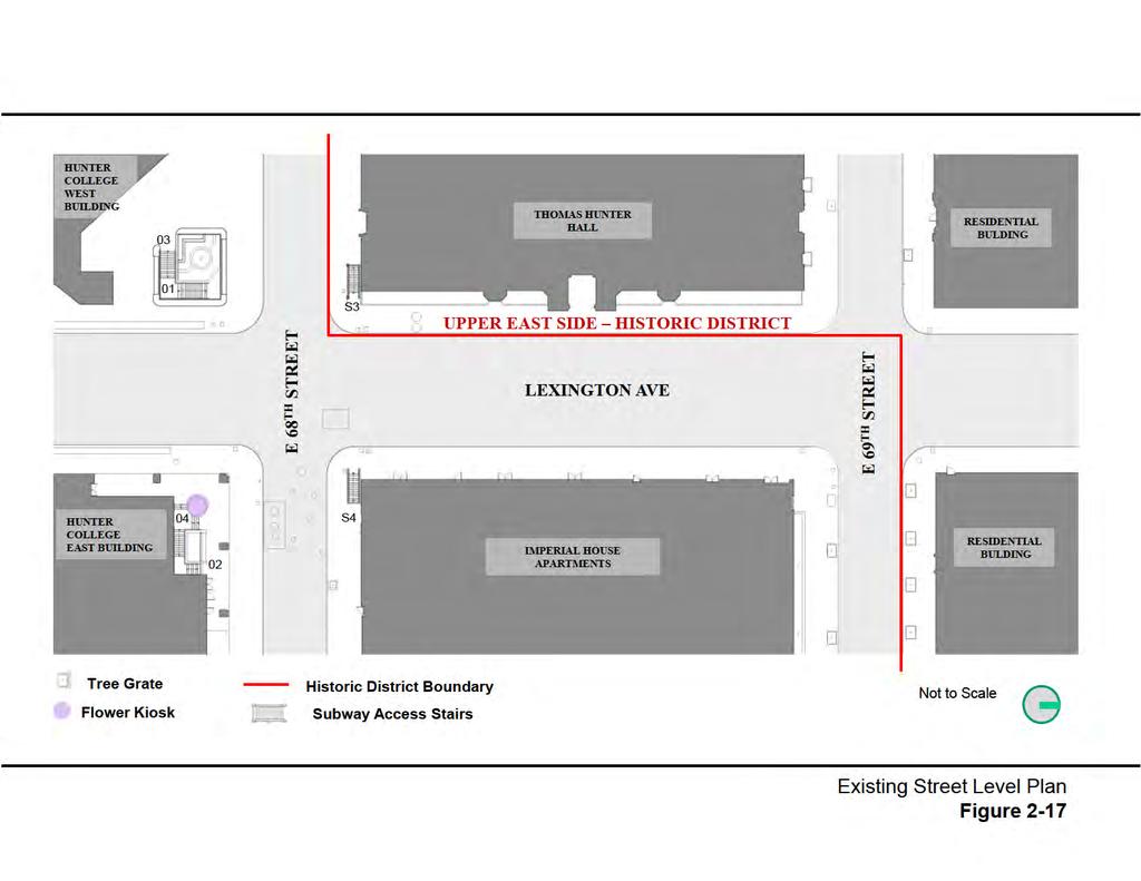
25 Chapter 2: Project Alternatives As used in this section, a path of travel includes a continuous, unobstructed way of pedestrian passage by means of which the altered area may be approached, entered, and exited, and which connects the altered area with an exterior approach (including sidewalks, parking areas, and streets), an entrance to the facility, and other parts of the facility. The term also includes the restrooms, telephones, and drinking fountains serving the altered area. An accessible path of travel may include walks and sidewalks, curb ramps and other interior or exterior pedestrian ramps, clear floor paths through corridors, waiting areas, concourses, and other improved areas, parking access aisles, elevators and lifts, bridges, tunnels, or other passageways between platforms, or a combination of these and other elements. The path of travel analysis was conducted to evaluate whether, upon completion of the proposed alterations to this key station, people using wheelchairs can reach all primary function areas needed to use the station (including platforms, ticketing, toilets, waiting rooms, drinking fountains, etc.), although their path of travel may vary from the general public access route. In addition the analysis evaluates whether the key station meets all other DOT Standards throughout for elements in place when the station was made accessible, including signs, detectable warnings on platform edges, accessible fare vending, text telephones, and visual display of public address announcements. The Proposed Project or the Proposed Project with Option E1 includes the following improvements: 1. An elevator (Elev. No. 282) from street level to mezzanine at the southeast corner East 68th Street. 2. Two elevators (Elev. Nos. 283 & 284) from mezzanine to southbound and northbound platforms. 3. Reconstruction and widening of mezzanine to street stair O2/O4 at the southeast corner of East 68th Street. 4. Reconstruction, reorientation and widening of mezzanine to street stair S4 at the northeast corner of East 68th Street. 5. Reconstruction and rehabilitation of street stair S3 at the northwest corner of East 68th Street. 6. An ADA-compliant employee toilet and employee locker room provided in the mezzanine. 7. New stair entrances to the subway at East 69th Street on the southwest corner of the intersection with Lexington Avenue next to the Thomas Hunter Hall Building and mid-block on Lexington Avenue inside a commercial space in the Imperial House Apartment building, or for the Proposed Action with Option E1 at the southeast corner of East 69th Street east of Lexington Avenue Siting Assumptions for Elevator and Stair Placement/Path of Travel To incorporate vertical access at this station, construction cost, constructability, underground utility relocation, ADA compliance, passenger flow/convenience, intermodal transfers, safety and security were evaluated. At street level, roadway and sidewalk width, traffic patterns, and bus routes/stops were reviewed. Within the existing constraints and the factors mentioned above, the proposed locations of the elevators provide the safest path of travel. Roadway traffic patterns and bus routes/stops, as well as property line limitations also were evaluated. Within these constraints, elevators and station entrances were sited in locations that could functionally best process current and future passenger loads while considering the following: 2-25
26 68 th Street/Hunter College Subway Station Improvement Project EA sited to be centrally located and provide the safest path of travel for disabled and other passengers on the street/sidewalk levels, sited to provide a safe distance from platform edges at the platform level for wheelchair users and pedestrians, sited in locations that would minimize the negative impact to vehicle flow, and to passenger flow within the stations. Designs were completed in accordance with the ADA Accessibility Guidelines as applicable to MTA NYCT. Figure 2-17 provides a depiction of the existing street level plan, illustrating the current four entry points on all four corners of East 68th Street and Lexington Avenue: stairs O1/O3, O2/O4, S3, and S4. It should be noted that this location represents one of the busiest local stations in the system. At many hours of the day, the two southern sets of stairs experience crush loads of passengers entering and exiting. Street-level Entrance Modifications As illustrated in Figure 2-18, a new elevator (282) at street level would be installed under Hunter College s East Building arcade, sheltered from rain and snow, away from vehicular traffic and not impeding sidewalk pedestrian traffic. The new elevator would be conveniently located next to the bus stop so that intermodal transfers are easy for passengers using the elevators. The adjacent entrance stairs (O2 and O4) would be widened to be 10.0 feet and would comply with all ADA regulations. The widening of the stairs alleviates existing overcrowding at this location. Stair S4 at the northeast corner of East 68th Street and Lexington Avenue would likewise be reconstructed and widened to 6.0 feet. It would be reoriented to egress towards the east. The stair egress reversal follows the preferred path of travel for most passengers existing the station via this stair. The new stair would comply with all ADA regulations. Stair S3 at the northwest corner of 68th Street and Lexington Avenue would be reconstructed and rehabilitated to comply with all ADA regulations. Subway Mezzanine Modifications As illustrated on Figure 2-19, two new elevators (283 and 284) would be installed on the mezzanine level to provide access to the southbound and northbound platforms. These elevators would be conveniently located next to stairs P1 and P2, which provide access between the mezzanine and the platforms below. Stair M2, at the southeast side of the mezzanine would be demolished and the structural slab in front of street elevator 282 would be extended to meet the level of the main mezzanine with the fare arrays. This would ensure an unobstructed path of travel for disabled and other passengers from the street elevator to the platform elevators on the mezzanine level. 2-26
27

28
29
30 68 th Street/Hunter College Subway Station Improvement Project EA Subway Platform Access As illustrated on Figure 2-20, the new elevator lobbies on each platform would not encroach into the existing platform area. The elevator lobbies adjoin the stair lobbies and are outside the confines of the current subway station public space. This configuration would allow passengers in wheelchairs to arrive on the platform level at a safe distance from the platform edge. Also, it would not impede passenger flow on the platform. Two new stair entrances would be provided on the north side of the platforms to improve passenger circulation and relieve overcrowding. The new stair on the southbound platform would provide egress at the southwest corner of East 69th Street and Lexington Avenue, next to Thomas Hunter Hall. The new stair entrance on the northbound platform would provide egress mid-block on Lexington Avenue through a commercial space in the Imperial House Apartments building. All stairs would comply with ADA regulations. These proposed changes would offer the most optimal combination of platform, mezzanine and street level improvements to achieve the maximum level of access for able and disabled passengers without impacting established and projected passenger loads. Street level impacts are likewise minimized by taking into account vehicular and pedestrian flows. These issues were closely coordinated with NYCDOT and the Community Board. 2.5 ANTICIPATED BENEFITS WITH THE PROPOSED PROJECT To assess the extent to which the project would address the transportation deficiencies that, along with the ADA modifications, form the basis for the purpose and need, conditions expected after completion of the project (Build Condition) were compared with conditions that would be expected without the project (No-Build Condition) for the year Transportation analyses completed for the Proposed Project are provided in Chapter 5 and in Appendix C. As described below, implementation of either the Proposed Project or the Proposed Project with Option E1 would address the deficiencies identified in Section 1.2, and would meet the project purpose and need, as well as the project goals and objectives described in Section An overview of how the Proposed Project would address the deficiencies is provided below. More detailed analyses are included in Chapter 5 and Appendix C. This Key Station would become ADA-compliant. With implementation of the station improvements, the station would provide ADA-compliant access to passengers with mobility impairments or other disabilities, thereby increasing the system-wide number of destinations accessible for these passengers. The station would also be ADA-accessible for employees of MTA NYCT. Reduced pedestrian congestion at platform stairs. With the addition of new stairs at the north end of the platform, the existing congestion at the stairs leading to the East 68th Street mezzanine would be reduced. Table 2-3 provides the clearance times for the platform stairs during peak periods under existing conditions and conditions expected in 2020 without and with the Proposed Project. These conditions are the same for the Proposed Project and the Proposed Project with Option E1. Although not all stairs would meet the 30-second clearance time guideline, 10 the Proposed Project would result in a substantial improvement of clearance times, especially for stairs performing poorly under existing conditions. 10 Methodology for Surged Flow Analysis, NYCT Division of Operations Planning/Station Planning, December

31
32 68 th Street/Hunter College Subway Station Improvement Project EA Table 2-3: Peak Clearance Times at Platform Stairs (Seconds) Stair ID Existing Conditions 2020 No-Build/ Build Conditions AM Peak PM Peak AM Peak PM Peak P /12 4/2 P /48 9/6 P /40 20/16 P /88 34/28 Clearance times exceeding the 30-second guideline are underlined and red Stair IDs are indicated on Figure Improved circulation at the mezzanine level. With the operation of new entrances, fewer passengers would be using the East 68th Street mezzanine. Under the Proposed Project in 2020, for the peak 15-minute period in the morning, approximately 28 percent fewer passengers (625 persons) would be using the East 68th Street mezzanine than would be the case under the No-Build condition. Similarly, in 2020, for the PM peak 15-minute period, approximately 26 percent fewer passengers (444 persons) would be using the East 68th Street mezzanine than would be the case under the No-Build condition. The reduction of passenger volume on the mezzanine would improve mezzanine circulation; with additional improvement resulting from the widening of street stairs as discussed below. Reduced pedestrian congestion at the street stairs. With the widening of stair O2/O4 on the southeast corner of the East 68th Street/Lexington Avenue intersection and stair S4 at the northeast corner of the intersection, and the new station access at East 69th Street, congestion at the street stairs is expected to be reduced under the Proposed Project when compared with the existing conditions and when compared with No-Build Conditions. During the 2020 AM peak, for example, LOS at stair S4 would improve from E to A, and stair O2/O4 would improve from LOS F to LOS C. Similar improvements are anticipated during the PM peak (Table 2-4). (These conditions are the same for the Proposed Project and the Proposed Project with Option E1.) Elimination of pedestrian interference at the northeast corner of East 68th Street and Lexington Avenue. The street stair at this location would be relocated east approximately 30 feet and reoriented so that passengers exiting the stair would be heading east. As such, exiting passengers would no longer emerge and interfere with pedestrian flow along the east sidewalk of Lexington Avenue. Passengers entering from the east would no longer have to negotiate through, and interfere with, pedestrians traveling along the east sidewalk of Lexington Avenue. Table 2-4: No-Build and Build LOS at East 68th Street Stairs Existing Conditions 2020 No-Build/ Build Conditions Stair ID/Location AM Peak PM Peak AM Peak PM Peak S4 Northeast Corner F D E/A D/A S3 Northwest Corner D B C/A A/A O2/O4 Southeast Corner F E E/C D/B O1/O3 Southwest Corner C B B/B A/A LOS E and worse are underlined and in red Stair IDs are indicated on Figure Improved efficiency of train access and occupancy. With the provision of additional access to the station at the northern end of the station, it is anticipated that most passengers with 2-32
33 Chapter 2: Project Alternatives origins/destinations north of East 68th Street would use the new entrances, and thus, utilize cars at the north end of the train, thereby providing greater balance in train loading/unloading and utilization, and better utilization of the platforms. Improved efficiency of pedestrian circulation and reduced walking time. With the new access to the station, passengers leaving trains at the north end of the platform with a destination north of East 68th Street would no longer have to double back to the north at street level along Lexington Avenue, resulting in more convenient station access. Similarly, passengers approaching the station from points north of East 68th Street could enter via the new entrances, avoiding the extra walk. Compared with Alternatives 1, 3, and 4, the Proposed Project and the Proposed Project with Option E1 would have fewer construction impacts. They would avoid disturbance of sensitive utilities, such as ECS duct banks and interference with historic Thomas Hunter Hall, thereby reducing construction risks, duration and costs. The Proposed Project and the Proposed Project with Option E1 would not require extensive excavation along Lexington Avenue and would therefore generate fewer construction impacts to businesses and residents on the avenue. Compared with the other build alternatives, the Proposed Project and the Proposed Project with Option E1 would require less work at the track level and therefore involve fewer interruptions of the transit system during construction. Station access conflicts would be minimized by providing alternate station access at the north end of the station during construction at East 68th Street. In addition to the above, an important advantage inherent in the design when compared with Alternative 1, is that the Proposed Project and the Proposed Project with Option E1 would provide two distinct and separate locations for station egress, one at East 68th Street and one at East 69th Street. As such, if need be, the station could be evacuated more quickly, and if events render one egress area inaccessible, an alternative means of egress would exist. 2-33
2.2 72ND STREET STATION ENTRANCE ALTERNATIVES
 Chapter 2: Entrance Alternatives 2.1 INTRODUCTION This chapter describes the alternatives that are evaluated in this Supplemental Environmental Assessment (EA) for the 72nd Street Station and 86th Street
Response to Community Questions Regarding Hunter College-68th Street ADA Project
 Response to Community Questions Regarding Hunter College-68th Street ADA Project 1. Has the MTA completed and/or published an Environmental Impact Statement or Environmental Assessment under NEPA (or the
ADA/TAS Plan Review & Inspection Worksheet Texas Access
 ADA/TAS Plan Review & Inspection Worksheet Texas Access www.texasaccess.com Client: Project No: Address: City/Town: State/ZIP: Project Type: PLAN REVIEW INSPECTION BY DATE Applicable to project scope Results:
M-43 CORRIDOR OVERLAY ZONE
 ARTICLE 26.00 M-43 CORRIDOR OVERLAY ZONE Section 26.01 Findings A primary function of the M-43 state highway is to move traffic through the Township and to points beyond. As the primary east-west arterial
12/18/2017. Objective. Accessibility Code MN 1341 Frequent Questions and Key Criteria. Agenda. Code Documents
 Objective Accessibility Code MN 1341 Frequent Questions and Key Criteria Highlight frequently asked Accessibility Code Questions Review the intent of the requirements Clarify the why behind the what of
3. Miscellaneous Instructions and Definitions.
 Last page revision- March 31st, 1999 TEXAS ACCESSIBILITY STANDARDS (TAS) TAS Table of Contents 3. Miscellaneous Instructions and Definitions. 3.1 Graphic Conventions. Graphic conventions are shown in Table
Draft Model Access Management Overlay Ordinance
 Draft Model Access Management Overlay Ordinance This model was developed using the City of Hutchinson and the Trunk Highway 7 corridor. The basic provisions of this model may be adopted by any jurisdiction
9. REZONING NO Vicinity of the northwest corner of 143 rd Street and Metcalf Avenue
 9. REZONING NO. 2002-15 Vicinity of the northwest corner of 143 rd Street and Metcalf Avenue 1. APPLICANT: Andrew Schlagel is the applicant for this request. 2. REQUESTED ACTION: The applicant is requesting
5. Land Acquisition and Displacement
 Northern Branch Corridor SDEIS March 2017 5. Land Acquisition and Displacement 5.1. Chapter Overview 5.1.1. Introduction Implementation of the Preferred Alternative would require the acquisition of property
DESIGN PUBLIC HEARING JANUARY 12, 2017 TOWN HALL SULLIVAN MEETING ROOM 558 SOUTH MAIN STREET RAYNHAM, MASSACHUSETTS 7:00 PM FOR THE PROPOSED
 DESIGN PUBLIC HEARING JANUARY 12, 2017 AT TOWN HALL SULLIVAN MEETING ROOM 558 SOUTH MAIN STREET RAYNHAM, MASSACHUSETTS 7:00 PM FOR THE PROPOSED REPLACEMENT OF BRIDGE NO. R-02-013 US ROUTE 44 OVER STATE
EXPRESS LANES NORTHERN EXTENSION TECHNICAL REPORT SEPTEMBER 2016
 I N T E R S TAT E 3 9 5 EXPRESS LANES NORTHERN EXTENSION R I G H T O F W AY TECHNICAL REPORT SEPTEMBER 2016 INTERSTATE 395 EXPRESS LANES NORTHERN EXTENSION Right of Way Technical Report City of Alexandria,
2018 CSBC / 2018 CSFSC Part III. Chapter #10. Means of Egress. Table of Contents. Based on the 2015 IBC and the 2015 IFC.
 2018 CSBC / 2018 CSFSC Part III. Chapter #10. Means of Egress. Table of Contents. Based on the 2015 IBC and the 2015 IFC. October 23, 2018 Section 1001. Administration. See Section 107.2.3 for Egress Drawing
WORKSHEET FOR ACCESSIBILITY UPGRADE REQUIREMENTS FOR EXISTING NON-RESIDENTIAL BUILDINGS
 Community Development and Sustainability Department 23 Russell Boulevard, Suite 2 Davis, California 95616 Phone: (530)757-5610 Fax: (530)757-5660 TDD: (530)757-5666 Website: http://community-development.cityofdavis.org/
CONSTRUCTION COST ESTIMATE AND ANALYSIS
 CONSTRUCTION COST ESTIMATE AND ANALYSIS As can be seen in the exhibits to this analysis, the total construction cost for the Alteration project is $790,324.11. However, under the state statute, section
Land Use Planning Analysis. Phase 2 Drayton Valley Annexation Proposal
 Land Use Planning Analysis Phase 2 Drayton Valley Annexation Proposal Prepared for Town of Drayton Valley Prepared by Mackenzie Associates Consulting Group Limited March, 2011 TABLE OF CONTENTS 1.0 INTRODUCTION...
Approval of Takoma Amended Joint Development Agreement and Compact Public Hearing
 Planning, Program Development and Real Estate Committee Item IV - B March 13, 2014 Approval of Takoma Amended Joint Development Agreement and Compact Public Hearing Washington Metropolitan Area Transit
DEPARTMENT OF DEVELOPMENT SERVICES ACCESSIBILITY CHECK LIST FOR MULTI-FAMILY RESIDENTIAL BUILDINGS
 DEPARTMENT OF DEVELOPMENT SERVICES ACCESSIBILITY CHECK LIST FOR MULTI-FAMILY RESIDENTIAL BUILDINGS City staff has compiled this partial checklist to assist developers with designing buildings in conformance
APPLICATION OF SECTION 3.8 OF THE 2012 ONTARIO BUILDING CODE FOR: BARRIER-FREE AUDIT OF SENECA COLLEGE NEWNHAM CAMPUS TORONTO, ONTARIO
 APPLICATION OF SECTION 3.8 OF THE 2012 ONTARIO BUILDING CODE FOR: BARRIER-FREE AUDIT OF SENECA COLLEGE NEWNHAM CAMPUS TORONTO, ONTARIO Prepared by: Rita Cherniavskaya & Elias Frechette Technical Consultants
DESIGN PUBLIC HEARING JULY 7, 2016 CITY COUNCIL HEARING ROOM, FIRST FLOOR ONE GOVERNMENT CENTER FALL RIVER, MASSACHUSETTS 6:30 PM FOR THE PROPOSED
 DESIGN PUBLIC HEARING JULY 7, 2016 AT CITY COUNCIL HEARING ROOM, FIRST FLOOR ONE GOVERNMENT CENTER FALL RIVER, MASSACHUSETTS 6:30 PM FOR THE PROPOSED AIRPORT ROAD OVER ROUTE 24, BRIDGE DECK REPLACEMENT
2014 OSSC CHAPTER 10 - MEANS OF EGRESS TABLE OF CONTENTS
 2014 OSSC CHAPTER 10 - MEANS OF EGRESS TABLE OF CONTENTS Section 1001 ADMINISTRATIVE 1001.1 General 1001.2 Alterations to existing means of egress 1001.3 Maintenance 1001.4 Fire safety and evacuation plans
2015 Downtown Parking Study
 2015 Downtown Parking Study City of Linden Genesee County, Michigan November 2015 Prepared by: City of Linden Downtown Development Authority 132 E. Broad Street Linden, MI 48451 www.lindenmi.us Table of
DESIGN PUBLIC HEARING FEBRUARY 28, 2018 KENNEDY MIDDLE SCHOOL, AUDITORIUM SPRINGFIELD, MASSACHUSETTS 6:30 PM FOR THE PROPOSED
 DESIGN PUBLIC HEARING FEBRUARY 28, 2018 AT KENNEDY MIDDLE SCHOOL, AUDITORIUM SPRINGFIELD, MASSACHUSETTS 6:30 PM FOR THE PROPOSED BAY STREET AND BERKSHIRE AVENUE INTERSECTION IMPROVEMENTS PROJECT NO. 608411
ACCESSIBILITY ADVISORY COUNCIL GROUNDS FOR APPROVAL. Fit-outs/Build-outs are considered new construction
 Economic Hardship GROUNDS FOR APPROVAL o Does the cost of providing vertical accessibility meet or exceed 20% of the cost of the alteration to the primary function area? o If the 20% threshold is met,
ZONING AMENDMENT & SUBDIVISION STAFF REPORT Date: November 3, 2016
 ZONING AMENDMENT & SUBDIVISION STAFF REPORT Date: November 3, 2016 APPLICANT NAME SUBDIVISION NAME David Shumer 5955 Airport Subdivision CITY COUNCIL DISTRICT District 6 5955 Airport Boulevard, 754 Linlen
Truax Park Apartments
 Truax Park Apartments Master Planning and Site Development Study Prepared by The Community Development Authority of the City of Madison In association with SMITH & SMITH ASSOCIATES, Inc CONSTRUCTION COST
Be linked by an internal circulation system (i.e., walkways, streets, etc.) to other structures within the IPUD;
 to other structures within the IPUD;") 2. HALIFAX ACTIVITY CENTER A. DESCRIPTIONS OF FUTURE LAND USE DESIGNATIONS Each of the future land use designations specified by Phase I of the Halifax Activity Center Plan, and the relationship of these
2. HALIFAX ACTIVITY CENTER A. DESCRIPTIONS OF FUTURE LAND USE DESIGNATIONS Each of the future land use designations specified by Phase I of the Halifax Activity Center Plan, and the relationship of these
SECTION 7000 LAND DEVELOPMENT REQUIREMENTS
 SECTION 7000 LAND DEVELOPMENT REQUIREMENTS 7000 LAND DEVELOPMENT REQUIREMENTS... 1 7001 LEGISLATIVE AUTHORITY... 1 7001.1 LAND DEVELOPMENT... 1 7001.1.1 Title 40, Idaho Code... 1 7001.1.2 Idaho Code 40-1415
Accessible drinking fountain does not have a clear 30 wide floor space centered on the drinking fountain (centerline to the counter edge is 12 ).
.") ADA STANDARD: PARKS SERVICE CENTER GARAGE 4.15.5(1), Figs. 4(e) and 27(b) Accessible drinking fountain does not have a clear 30 wide floor space centered on the drinking fountain (centerline to the counter
ADA STANDARD: PARKS SERVICE CENTER GARAGE 4.15.5(1), Figs. 4(e) and 27(b) Accessible drinking fountain does not have a clear 30 wide floor space centered on the drinking fountain (centerline to the counter
3.3 Acquisitions and Displacements/Relocations
 Chapter 3 Social Effects 3.3 Acquisitions and Displacements/Relocations This section discusses property displacements, relocations, and acquisitions (partial or full) that might occur due to implementation
Sudler Annex 092/3725 Various Accessibility Improvements 04/2012 Included accessible ramp to entrance and accessible restroom.
 KU TRANSITION PLAN 1 ACADEMIC ACCESSIBILITY PROJECTS 2 June 29, 2017 LOCATION PROJ # PROJECT TOPIC / NAME COMPLETION COMMENTS 2012 Strong Hall Fire Alarm Strobe Upgrades 12/2012 Strong Hall Add Handrails
Approval of Takoma Amended Joint Development Agreement
 Planning, Program Development and Real Estate Committee Item IV- A October 10, 2013 Approval of Takoma Amended Joint Development Agreement Washington Metropolitan Area Transit Authority Board Action/Information
Section 1: US 19 Overlay District
 Section 1: US 19 Overlay District Section 1.1 Intent and Purpose The purpose of the US Highway 19 Overlay District is to manage access to land development along US Highway 19 in a manner that preserves
The Philadelphia Code. In order to be eligible for any floor area bonuses pursuant to this section:
 1 of 16 2/17/2015 2:47 PM The Philadelphia Code 14-702. Floor Area and Height Bonuses. 225.1 (1) Purpose. The intent of the floor area bonus provisions is to encourage certain types of development and
HANDICAPPED ACCESSIBILITY TOOLKIT
 HANDICAPPED ACCESSIBILITY TOOLKIT By: Mike Ferguson, P.E. Director of Engineering Services As a PCNA provider, we discuss handicapped accessibility design and construction issues daily. Accessibility guidelines
TROWBRIDGE & WOLF. August 21, 2002 WEST CAMPUS RESIDENTIAL INITIATIVE DEIS ADDENDUM THREE
 TROWBRIDGE & WOLF L a n d s c a p e A r c h i t e c t s P l a n n e r s August 21, 2002 WEST CAMPUS RESIDENTIAL INITIATIVE DEIS ADDENDUM THREE 1. Replace pages 121-a, 121-b and 121-c Section 2.11 Community
Rezoning Petition Final Staff Analysis May 21, 2018
 Rezoning Petition 2017-182 Final Staff Analysis May 21, 2018 REQUEST LOCATION Current Zoning: R-3 (single family) and no zoning (current NC State right-of-way) Proposed Zoning: B-2(CD) (general business,
DESIGN PUBLIC HEARING
 DESIGN PUBLIC HEARING October 25, 2016 AT STEVENS MEMORIAL LIBRARY 345 MAIN STREET NORTH ANDOVER, MASSACHUSETTS 7:00 PM FOR THE PROPOSED Chickering Road (Route 125) & Massachusetts Avenue Intersection
PLANNED UNIT DEVELOPMENT & SUBDIVISION STAFF REPORT Date: April 18, 2019
 PLANNED UNIT DEVELOPMENT & SUBDIVISION STAFF REPORT Date: April 18, 2019 DEVELOPMENT NAME SUBDIVISION NAME Springhill Village Subdivision Springhill Village Subdivision LOCATION 4350, 4354, 4356, 4358,
Agenda Report DATE: APRIL 30,2007 TO: CITY COUNCIL CYNTHIA J. KURTZ, CITY MANAGER FROM:
 Agenda Report DATE: APRIL 30,2007 TO: FROM: SUBJECT: CITY COUNCIL CYNTHIA J. KURTZ, CITY MANAGER APPROVAL OF THE DEVELOPMENT AGREEMENT FOR THE SMVIA NOISE WITHIN MIXED-USE PROJECT BETWEEN THE ClTY OF PASADENA
Purpose. Scope. Stairway Identification Signs. Emergency Evacuation and Stairwell Signage Requirements
 TOWN OF BRIGHTON Office of the Fire Marshal 2300 Elmwood Avenue Rochester, New York 14618 (585) 784-5220 Office (585) 784-5207 Fax Emergency Evacuation and Stairwell Signage Requirements The intent of
Arlington County. Smart Choice Homes. Arlington County. Homes for all of us. Homes for a lifetime. Home
 Arlington County Smart Choice Homes Home Arlington County Homes for all of us. Homes for a lifetime Why Smart Choice Homes? Smart design equals smart living. This booklet provides the building blocks to
The Philadelphia Code. Table : Commercial and Commercial Mixed-Use Districts {For a printable PDF version, click HERE}
 1 of 19 2/17/2015 2:48 PM The Philadelphia Code 14-402. Commercial and Commercial Mixed-Use Districts. (1) General. (a) Districts. (.1) List. The City s Commercial and Commercial Mixed-Use zoning districts
E1-12: Final Decision AS
 BCAC COMPILATION OF GROUP A E1-12: Final Decision AS 202, 1006 (New), 1007 (New), 1014.3, 1015, 1020.1, 1021 (IFC [B] 1006 (New), 1007 (New), 1014.3, 1015, 1020.1, 1021) Proponent: Charles S. Bajnai, Chesterfield
The Miramar Santa Monica
 The Miramar Santa Monica Project Description The Santa Monica Miramar Hotel (the Miramar or the Hotel ) has been an institution in the City of Santa Monica since originally opening on the site in 1920.
NEW ACCESSIBILITY CHANGES
 NEW ACCESSIBILITY CHANGES TO THE ONTARIO BUILDING CODE An outline of the accessibility changes made to the Ontario Building Code by Ontario Regulation 368/13. May 9, 2014 OAA CONFERENCE Continuing Education
2012 Texas Accessibility Standards Reference Guide for changes to the code
 2012 Texas Accessibility Standards Reference Guide for changes to the code SCOPING ITEMS Children s Mounting Heights Elements primarily used by children are no longer required to comply with the appropriate
Access to and use of buildings
 The Building Regulations 2010 Access to and use of buildings APPROVED DOCUMENT M Volume 1: Dwellings M4(1) Category 1: Visitable dwellings M4(2) Category 2: Accessible and adaptable dwellings M4(3) Category
Watkinsville First Baptist Church Building and Parking Masterplan Norton Road & Simonton Bridge Road Oconee County Georgia
 Watkinsville First Baptist Church Building and Parking Masterplan Norton Road & Simonton Bridge Road Oconee County Georgia Special Use Approval A-1 CUP to A-1 with Special Use Approval Total Site Area
Section 1. Appendix A, "Zoning" of the Code of the City of Charlotte is hereby amended as follows:
 Petition No. 2009-078 Petitioner: Charlotte-Mecklenburg Planning Commission ORDINANCE NO. AN ORDINANCE AMENDING APPENDIX A OF THE CITY CODE ZONING ORDINANCE Revised 12-10-09 BE IT ORDAINED BY THE CITY
Article 3. SUBURBAN (S-) NEIGHBORHOOD CONTEXT
 NEIGHBORHOOD CONTEXT") Article 3. SUBURBAN (S-) NEIGHBORHOOD CONTEXT this page left intentionally blank Contents ARTICLE 3. SUBURBAN (S-) NEIGHBORHOOD CONTEXT DIVISION 3.1 NEIGHBORHOOD CONTEXT DESCRIPTION...3.1-1 Section 3.1.1
Article 3. SUBURBAN (S-) NEIGHBORHOOD CONTEXT this page left intentionally blank Contents ARTICLE 3. SUBURBAN (S-) NEIGHBORHOOD CONTEXT DIVISION 3.1 NEIGHBORHOOD CONTEXT DESCRIPTION...3.1-1 Section 3.1.1
Chapter 7 Riverfront District
 Chapter 7 Riverfront District Downtown Capital District Master Plan Trenton, New Jersey Riverfront District Trenton will reclaim its connection with the Delaware River to enhance the experience of living,
Claremont Club, Spa & Residences Project Description November 22,2016
 Claremont Club, Spa & Residences Project Description November 22,2016 Project Location, Site Description and Ownership The approximate 20.3 acre Claremont Club, Spa and Residences project ( Claremont Resort
SHORE DRIVE CORRIDOR: PAST, PRESENT, & FUTURE APRIL 19, 2018 BAYFRONT ADVISORY COMMISSION
 SHORE DRIVE CORRIDOR: PAST, PRESENT, & FUTURE APRIL 19, 2018 BAYFRONT ADVISORY COMMISSION 1 OVERVIEW I. Shore Drive Corridor Overview II. Shore Drive Corridor History III. Completed Projects IV. Current
Task Force on Kai Tak Harbourfront Development
 Task Force on Kai Tak Harbourfront Development For discussion on 14 May 2013 TFKT/07/2013 Central Kowloon Route - Kai Tak and Ma Tau Kok PURPOSE This paper seeks Members views on preliminary proposals
ARTICLE IV: DEVELOPMENT STANDARDS
 ARTICLE IV: DEVELOPMENT STANDARDS IV-53 409 PRIVATE STREETS A private street means any way that provides ingress to, or egress from, property by means of vehicles or other means, or that provides travel
PLNSUB Meridian Commerce Center Subdivision Amendment & PLNPCM Meridian Commerce Center Street Closure
 Staff Report PLANNING DIVISION COMMUNITY & ECONOMIC DEVELOPMENT To: From: Salt Lake City Planning Commission Daniel Echeverria, 801-535-7165, daniel.echeverria@slcgov.com Date: September 4, 2014 Re: PLNSUB2014-000469
General Information. Location Information. Location Use. Colorado VSPC/Drop-off/Drop-box Accessibility Survey Form. For SOS office use only
 Colorado VSPC/Drop-off/Drop-box Accessibility Survey Form Complete all sections of the survey below if you are using the site as a full VSPC and/or a drop off site. If you are using the site as a Drop
9 February 9, 2011 Public Hearing APPLICANT / PROPERTY OWNER:
 9 February 9, 2011 Public Hearing APPLICANT / PROPERTY OWNER: KROGER LIMITED PARTNERSHIP I REQUEST: Conditional Use Permit (Automobile Service Station) STAFF PLANNER: Leslie Bonilla ADDRESS / DESCRIPTION:
Facilities providing accommodation for the public (e.g. Hotels, hostels, guesthouses, self catering apartments).
.") Facilities providing accommodation for the public (e.g. Hotels, hostels, guesthouses, self catering apartments). These buildings shall comply with the Access for All Design Guidelines as well as indicated
Facilities providing accommodation for the public (e.g. Hotels, hostels, guesthouses, self catering apartments). These buildings shall comply with the Access for All Design Guidelines as well as indicated
Planning Commission Report
 Beverly Hills Planning Division 455 N. Rexford Drive Beverly Hills, CA 90210 TEL. (310) 458-1140 FAX. (310) 858-5966 Planning Commission Report Meeting Date: September 27, 2012 Subject: 366 North Rodeo
REPORT TO THE SHELBY COUNTY PLANNING COMMISSION From the Department of Development Services Planning Services. February 4, 2019
 REPORT TO THE SHELBY COUNTY PLANNING COMMISSION From the Department of Development Services Planning Services February 4, 2019 Case No. Request for Rezoning Approval From E-1 to E-2 SD This is a request
ATTACHMENT A REQUEST/BACKGROUND INFORMATION VENTURA/TYRONE REDEVELOPMENT PROJECT PROJECT OVERVIEW/REQUEST BACKGROUND Ventura Boulevard
 Revised October 28, 2016 ATTACHMENT A REQUEST/BACKGROUND INFORMATION VENTURA/TYRONE REDEVELOPMENT PROJECT Sherman Oaks, CA 91423 PROJECT OVERVIEW/REQUEST The Applicant, 14311 Ventura Development, LLC,
CITY OF SANTA ROSA COMMUNITY DEVELOPMENT DEPARTMENT STAFF REPORT FOR PLANNING COMMISSION SEPTEMBER 10, 2015 APPLICANT FILE NUMBER MJP
 ITEM NO. 9 CITY OF SANTA ROSA COMMUNITY DEVELOPMENT DEPARTMENT STAFF REPORT FOR PLANNING COMMISSION SEPTEMBER 10, 2015 PROJECT TITLE Yogurt Time Center ADDRESS/LOCATION 3093 Marlow Road ASSESSOR S PARCEL
MONTGOMERY COUNTY PLANNING DEPARTMENT THE MARYLAND-NATIONAL CAPITAL PARK AND PLANNING COMMISSION
 MONTGOMERY COUNTY PLANNING DEPARTMENT THE MARYLAND-NATIONAL CAPITAL PARK AND PLANNING COMMISSION MCPB Item No.: 10 Date: 06-28-18 Park Potomac: Site Plan Amendment No. 82004015N Benjamin Berbert, Planner
THIS CHECKLIST HAS BEEN AMENDED TO INCLUDE ONLY LEVEL ONE CRITERIA AS REQUESTED BY TIR REAL PROPERTY. As such it does not form a complete Checklist.
 Nova Scotia Building Accessibility Checklist Note OTE THIS CHECKLIST HAS BEEN AMENDED TO INCLUDE ONLY LEVEL ONE CRITERIA AS REQUESTED BY TIR REAL PROPERTY. As such it does not form a complete Checklist.
THEATER EVACUATION AND EMERGENCY SITUATION GUIDELINES THEATER EVACUATION
 As a volunteer RedCoat, you have a unique role in the safety of guests who attend shows at Playhouse Square. We ask that you take this role very seriously. In an emergency, our primary responsibility is
Residential Accessible, Type A, and Type B Dwelling Unit Requirements 2012 International Building Code and 2009 ICC/ANSI A117.1
 Residential Accessible, Type A, and Type B Dwelling Unit Requirements 2012 International Building Code and 2009 ICC/ANSI A117.1 20 E Olive Street STE 208 PO Box 1230 Bozeman, MT 59771-1230 Phone: (406)
City of Brooklyn Park Planning Commission Staff Report
 City of Brooklyn Park Planning Commission Staff Report Agenda Item: 6D Meeting Date: August 9, 2017 Originating Agenda Section: Public Hearing Department: Community Development Resolution: X Ordinance:
THE DISTRICT OF COLUMBIA LOTTERY AND CHARITABLE GAMES CONTROL BOARD NOTICE OF FINAL RULEMAKING
 THE DISTRICT OF COLUMBIA LOTTERY AND CHARITABLE GAMES CONTROL BOARD NOTICE OF FINAL RULEMAKING The Executive Director of the District of Columbia Lottery and Charitable Games Control Board, pursuant to
ADAPTABLE DESIGN GUIDELINES
 ADAPTABLE DESIGN GUIDELINES Adaptable design creates liveable residences for a wider range of persons than current building codes require. By considering design features that can be easily and inexpensively
STAFF REPORT. March 14, Toronto and East York Community Council. Director, Community Planning, South District
 STAFF REPORT March 14, 2005 To: From: Subject: Toronto and East York Community Council Director, Community Planning, South District Preliminary Report Official Plan Amendment and Rezoning Application 05
4 June 11, 2014 Public Hearing
 4 June 11, 2014 Public Hearing APPLICANT: FRANKLIN JOHNSTON MANAGEMENT DEVELOPMENT, L.L.C. PROPERTY OWNER: TRUSTEES OF FIRST LYNNHAVEN BAPTIST CHURCH STAFF PLANNER: Stephen J. White REQUEST: Change of
Jasper 115 Street DC2 Urban Design Brief
 Jasper 115 Street DC2 Urban Design Brief Greenlong Construction Ltd. Stantec Consulting Ltd. 2017 Overview The proposed rezoning application supports the development of two mixed-use high-rise buildings
Hotel Accessibility Pack
 Hotel Accessibility Pack Thank you for considering the Hilton Aberdeen Treetops Hotel. We are pleased to provide you with information about our hotel and our accessible facilities and services that you
CITY OF MERCED SMALL LOT SINGLE-FAMILY HOME DESIGN GUIDELINES
 CITY OF MERCED SMALL LOT SINGLE-FAMILY HOME DESIGN GUIDELINES Development Services Department Planning and Permitting Adopted August 15, 2005 SMALL LOT SINGLE FAMILY HOME GUIDELINES A. Purpose and Applicability.
Displacement and Relocation
 Chapter 7: and Relocation 7.1 INTRODUCTION This chapter summarizes the displacement and relocation impacts previously identified in the Final Environmental Impact Statement (FEIS) and then evaluates the
LeBreton Flats Redevelopment Development Summary Chart (First Subdivision)
") Redevelopment Development Summary Chart (First Subdivision) Development Analysis Chart NOTE: THE FOLLOWING TABLE REPRESENTS THE RESULTS OF THE NCC'S DEMONSTRATION OF DEVELOPMENT CAPACITY. WHILE ACTUAL
Redevelopment Development Summary Chart (First Subdivision) Development Analysis Chart NOTE: THE FOLLOWING TABLE REPRESENTS THE RESULTS OF THE NCC'S DEMONSTRATION OF DEVELOPMENT CAPACITY. WHILE ACTUAL
Supplemental Feasibility Study for Ravenswood, Oak Grove, Glenwood and Encinal Avenues Grade Separation. for the. City of Menlo Park
 Supplemental Feasibility Study for Ravenswood, Oak Grove, Glenwood and Encinal Avenues Grade Separation for the City of Menlo Park 1 2 Location Map SRI City Hall Alma El Camino Real Ravenswood Oak Grove
ADMINISTRATIVE HEARING STAFF REPORT
 ADMINISTRATIVE HEARING STAFF REPORT Providence Place Apartments Utility Box No. 2 Conditional Use Petition PLNPCM2011-00426 309 East 100 South September 22, 2011 Planning and Zoning Division Department
BETHESDA STATION MONTGOMERY COUNTY COUNCIL T&E COMMITTEE PROJECT BRIEFING SEPTEMBER 23, 2010
 BETHESDA STATION SOUTH ENTRANCE & CAPITAL CRESCENT TRAIL MONTGOMERY COUNTY COUNCIL T&E COMMITTEE PROJECT BRIEFING SEPTEMBER 23, 2010 Agenda 1. Project Description 4. Renderings Ridership and Operation
ACCESSIBILITY (DESIGN AND CONSTRUCTION) REQUIREMENTS FOR COVERED MULTIFAMILY DWELLINGS UNDER THE FAIR HOUSING ACT
 REQUIREMENTS FOR COVERED MULTIFAMILY DWELLINGS UNDER THE FAIR HOUSING ACT") U.S. DEPARTMENT OF HOUSING AND URBAN DEVELOPMENT OFFICE OF FAIR HOUSING AND EQUAL OPPORTUNITY U.S. DEPARTMENT OF JUSTICE CIVIL RIGHTS DIVISION Washington, D.C. April 30, 2013 JOINT STATEMENT OF THE DEPARTMENT
U.S. DEPARTMENT OF HOUSING AND URBAN DEVELOPMENT OFFICE OF FAIR HOUSING AND EQUAL OPPORTUNITY U.S. DEPARTMENT OF JUSTICE CIVIL RIGHTS DIVISION Washington, D.C. April 30, 2013 JOINT STATEMENT OF THE DEPARTMENT
IMPORTANT INFORMATION TRANSPORT CHANGES AND CONSTRUCTION WORKS, DOMAIN
 IMPORTANT INFORMATION TRANSPORT CHANGES AND CONSTRUCTION WORKS, DOMAIN Works in preparation for major construction of the Metro Tunnel are underway in Domain. New tram infrastructure will be built on and
Community Development Department
 Community Development Department SUBJECT: Reconsideration of Final Site Plan Review, Preliminary Subdivision, and Planned Development for Park Place Glenview at 1225 Waukegan Road MEETING DATE: March 28,
PLACEMENT OF SECURITY HUTS ON CITY OWNED LAND
 PLACEMENT OF SECURITY HUTS ON CITY OWNED LAND Policy No: 17957 Approved by Council 29 May 2014 C 39/05/14 Contents 1. Definitions 2. Problem Statement 3. Desired Outcomes 4. Strategic Intent 5. Role Players
Section 4 Master Plan Framework
 Section 4 Master Plan Framework 4.1 PURPOSE The Master Plan, as an implementation tool of the SPC District, establishes the primary framework for the overall development of the Property. Detailed site
Arriving and Getting In
 Waldorf St Martins Apartment Hotel Accessibility Report - 8/6/18 Waldorf St Martins offers 4 x One Bedroom Accessible Apartments for short term accommodation, in Auckland CBD, close to all central attractions
WALNUT CREEK DESIGN REVIEW COMMISSION STUDY SESSION STAFF REPORT
 WALNUT CREEK DESIGN REVIEW COMMISSION STUDY SESSION STAFF REPORT AGENDA: December 3, 2014 ORIGINATED BY: Community and Ecomic Development Department ITEM: 4d Day/Date/Time Place Project Name Application
PLANNED UNIT DEVELOPMENT & SUBDIVISION STAFF REPORT August 18, 2016
 PLANNED UNIT DEVELOPMENT & SUBDIVISION STAFF REPORT August 18, 2016 DEVELOPMENT NAME SUBDIVISION NAME Mullinax Ford Subdivision Mullinax Ford Subdivision LOCATION CITY COUNCIL DISTRICT District 6 Southeast
ORDINANCE NO (As Amended)
") ORDINANCE NO. 01-2015 (As Amended) To Amend the Official Zoning Map of the City of Worthington, Ohio, to Change Zoning of Certain Land from the C-3 District (Institutions and Office), AR-4.5 District (Low
ORDINANCE NO. 01-2015 (As Amended) To Amend the Official Zoning Map of the City of Worthington, Ohio, to Change Zoning of Certain Land from the C-3 District (Institutions and Office), AR-4.5 District (Low
Residential roof decks. Residential Roof Decks
 Residential roof decks San Francisco Magazine cover Feb 2018 Issue Roof Decks and Discretionary Reviews Increasing number of cases / amount of time spent on Discretionary Reviews on projects involving
CITY OF LOGAN REDEVELOPMENT AGENCY. A Resolution approving the Auto Mall Community Development Project Area Plan
 -~ LOGAN CITY UNITED IN HRVICE fstt,blished 18t6 CITY OF LOGAN REDEVELOPMENT AGENCY Resolution No. IS-03 RDA A Resolution approving the Auto Mall Community Development Project Area Plan WHEREAS, the Redevelopment
Emergency Evacuation and Stairwell Signage
 Orange County Fire Authority Community Risk Reduction 1 Fire Authority Road, Building A, Irvine, CA. 92602 www.ocfa.org 714-573-6100 Emergency Evacuation and Stairwell Signage Guideline E-02 Serving the
O-I (Office-Institutional) and AG-1(Agricultural)
 and AG-1(Agricultural)") PROPERTY INFORMATION ADDRESS 3503 and 3505 Bethany Bend DISTRICT, LAND LOTS 2/1 973 and 974 OVERLAY DISTRICT State Route 9 PETITION NUMBERS EXISTING ZONING O-I (Office-Institutional) and AG-1(Agricultural)
PROPERTY INFORMATION ADDRESS 3503 and 3505 Bethany Bend DISTRICT, LAND LOTS 2/1 973 and 974 OVERLAY DISTRICT State Route 9 PETITION NUMBERS EXISTING ZONING O-I (Office-Institutional) and AG-1(Agricultural)
ORDINANCE NO. City Attorney Synopsis
 ORDINANCE NO. AN ORDINANCE OF THE COUNCIL OF THE CITY OF BURBANK APPROVING A PLANNED DEVELOPMENT FOR PROJECT NO. 10-0000835 AND SECOND AMENDMENT TO THE DEVELOPMENT AGREEMENT (BURBANK-GLENDALE-PASADENA
PROCEDURES FOR ROOM NUMBERING STANDARDS
 PROCEDURES FOR ROOM NUMBERING STANDARDS PURPOSE o o o Identify and assign numbers to individual spaces in university buildings. Provide location information for university employees, students, visitors
Questions and Answers for RFA Housing Credit Financing for the Preservation of Existing Affordable Multifamily Housing Developments
 Questions and Answers for RFA 2018-113 - Housing Credit Financing for the Preservation of Existing Affordable Multifamily Housing Developments Question 1: Are the 08-16 version of the Ability to Proceed
Upper Dublin Public Library. Master Plan Presentation for: 520 Virginia Drive
 Master Plan Presentation for: 520 Virginia Drive May 22, 2018 Design Presentation Agenda Master Plan Design for 520 Virginia Drive Existing Conditions & Opportunities Project Goals Site Plan & Floor Plans
LAKE MERRITT STATION AREA PLAN
 LAKE MERRITT STATION AREA PLAN Emerging Plan Open House Summary October 2011 2 1 Introduction The City of Oakland, Bay Area Rapid Transit (BART), and the Peralta Community College District, through a grant
CITY OF VACAVILLE PLANNING COMMISSION Agenda Item No. G.1 STAFF REPORT September 15, 2009 Staff Contact: Peyman Behvand (707)
") CITY OF VACAVILLE PLANNING COMMISSION Agenda Item No. G.1 STAFF REPORT September 15, 2009 Staff Contact: Peyman Behvand (707) 449-5140 TITLE: REQUEST: RECOMMENDED ACTION: SONIC DRIVE-IN APPROVE A MODIFICATION
CITY OF VACAVILLE PLANNING COMMISSION Agenda Item No. G.1 STAFF REPORT September 15, 2009 Staff Contact: Peyman Behvand (707) 449-5140 TITLE: REQUEST: RECOMMENDED ACTION: SONIC DRIVE-IN APPROVE A MODIFICATION
DEVELOPMENT DEPARTMENT STAFF REPORT DRESDEN HEIGHTS PHASE II DCI
 DEVELOPMENT DEPARTMENT Meeting Date: January 10, 2019 Item #: PZ2019-393 Project Name: Applicant and Owner: Proposed Development: Requests: STAFF REPORT DRESDEN HEIGHTS PHASE II DCI Dresden Heights Phase