COMMUNITY DEVELOPMENT DEPARTMENT
|
|
|
- Sherman Taylor
- 5 years ago
- Views:
Transcription
1 COMMUNITY DEVELOPMENT DEPARTMENT Council Meeting Date: April 22, 2008 Staff Report #: Agenda Item #: E-1 PUBLIC HEARING: Consideration of a Request for a Two-year Extension of a Planned Development Permit and Vesting Tentative Map Approval for the Construction of a New 26,800-Square-Foot, Commercial Building and 16 Townhomes, and a Planned Development Permit Amendment to Modify a Condition of Approval Regarding the Installation of a Temporary Eight-foot High Plywood Noise Barrier Around the Perimeter of the Project Site Located at 1460 El Camino Real. RECOMMENDATION Staff recommends approval of the Planned Development Permit (PDP) and Vesting Tentative Map extensions for a period of two years for the approved 1460 El Camino Real mixed-use project, and an amendment to the PDP that would modify the location of a temporary eight-foot high plywood noise barrier around the perimeter of the project site during construction. The findings and actions for approval as recommended by staff are provided as Attachment A. The Planning Commission recommends that the City Council also approve the proposed requests, with exception that the extensions be for a period of one year instead of two as identified in Attachment B. BACKGROUND On August 1, 2006, the City Council approved (4-0, with Council Member Cohen recused) land use entitlements for development of a 26,800 square-foot, two story commercial building and 16 attached residential units on four parcels, containing the addresses 1452 and 1460 El Camino Real and 1457 and 1473 San Antonio Street, which are collectively known as 1460 El Camino Real. The specific entitlements are listed below: 1. Rezoning The property was rezoned from C-4 (General Commercial District, Applicable to El Camino Real) to PD (Planned Development District); 2. Planned Development Permit (PDP) The permit established specific uses and development regulations and architectural designs;
2 Page 2 of 7 Staff Report # Vesting Tentative Subdivision Map The map merged four parcels and subdivided the land into 18 lots, including 16 residential lots, one common lot for the residential units, and one commercial lot for condominium purposes with a maximum of 40 commercial condominium units; 4. Below Market Rate (BMR) Housing Agreement The agreement provided three below market rate units on-site; 5. Heritage Tree Permit The permit allowed for the removal of one heritage tree; and 6. Environmental Impact Report (EIR) The EIR analyzed potential environmental impacts as a result of the project. Following the project s approval, the applicant began the process to decommission three dry wells on the property to evaluate ground water quality as recommended in the Phase I Environmental Site Assessment report included in the EIR prepared for the project. During the initial work, contaminants were discovered in the soil, and additional sampling and investigation was conducted. The information is under review by the County of San Mateo Health Department, and it is anticipated to be another month before a response is provided and the next steps are identified. The applicant has stated that the additional testing and review has resulted in unexpected delays in the project, and therefore, is now seeking a two-year extension on the PDP and vesting tentative map. Concurrently, the applicant is also seeking an amendment to the PDP to modify condition regarding installation of a temporary eight-foot high plywood noise barrier around the perimeter of the site. Both of these items are further discussed below. Planning Commission Review On March 10, 2008, the Planning Commission reviewed the proposed request for a twoyear time extension on the PDP and vesting tentative map, and the modification to condition , which was also noise mitigation measure in the EIR. The staff report and an excerpt of the approved minutes from the meeting of March 10, 2008 are included as Attachments C and D, respectively. At the meeting, staff distributed correspondence, which was sent earlier that day, from the applicant s attorney regarding a modified request regarding the location of the eight-foot high plywood barrier. This correspondence is included as Attachment E. The applicant requested to reduce the required location of the plywood fence to only the San Antonio Street frontage and the southerly property line of the subject site to specifically address potential noise impacts to the adjacent and nearby residential uses across San Antonio Street as identified in the EIR. Upon review of the applicant s modified request with the City Attorney, staff indicated to the Planning Commission at the meeting that the requested revision to the noise mitigation measure could be made under the existing EIR for the project, subject to wrapping the plywood fence around the northeast corner
3 Page 3 of 7 Staff Report # of the site for a minimum of 20 feet in length to account for residential properties located northeast of the subject site. Two members of the public spoke on the proposed project at the Commission meeting. One member of the public stated support for the project, but requested that the Planning Commission only recommend approval of a one-year extension to encourage the applicant to move more quickly on the development of the project. The member of the public indicated that it was his belief the project could sit idle and return with a denser project in the future should plans for the area change as a result of the El Camino Real/Downtown Visioning Plan efforts. The second member of the public who spoke lives adjacent to the subject site, and stated she wanted assurance that she would be protected from the noise impact during construction. The Commission discussed the appropriateness of a one- versus two-year extension and the location of the plywood fence. Some Commissioners felt that one year from August 1, 2008 was a reasonable timeframe for the remaining work while one Commissioner stated that a one-year extension was appropriate because he believed the community would prefer the project to get built sooner than later. Several Commissioners supported a two-year extension given the remaining work that needs to be completed prior to building permit submittal, and the unusual market conditions of today, with potential difficulties in obtaining financing. The Planning Commission recommended that the City Council approve a one-year extension for the PDP and vesting tentative map, with the ability for a one-year extension from August 1, 2009 to August 1, 2010, which could be considered as a Planning Commission consent calendar item. As recommended by the Commission, the additional one-year extension would not require City Council review or approval. With respect to the plywood fencing, the Planning Commission recommended that condition be modified to exclude plywood fencing along the El Camino Real frontage, the northerly side property line for a distance of 100 feet from the El Camino Real property line, and the southerly side property line for a distance of 150 feet from the El Camino Real property line. The motion passed unanimously. The recommended action and findings, as recommended by the Planning Commission, is included in Attachment B. Following the Planning Commission meeting, the applicant corresponded with one of the speakers at the March 10, 2008 Planning Commission meeting regarding the intentions of the project. The correspondence is included as Attachment F. The correspondence states that concerns expressed at the March 10, 2008 Commission meeting have been alleviated, and therefore, the speaker now supports a two-year extension.
4 Page 4 of 7 Staff Report # ANALYSIS Planned Development Permit and Vesting Tentative Map Extensions Per the terms outlined in item 5.1 of the PDP, the permit shall expire two years from the date of approval if the applicant does not submit a complete building permit application. Likewise, the Subdivision Ordinance states that a vesting tentative map shall also expire two years from the date of approval. An extension or extensions of a vesting tentative map can be requested for a period, in aggregate, not exceeding two years. Rather than applying for a one-year extension at this time with the potential to return for a second extension request, the applicant wishes to bundle the PDP and vesting tentative map requests, and is asking for a two-year extension of the approvals at this time. With the exception of the proposed request to condition regarding noise mitigation, which is discussed below in the Planned Development Permit Amendment section, the approved project would remain unchanged. Since the approval of the project, the City has embarked on the El Camino Real/Downtown Visioning Plan (Phase1), which is intended to inform and guide an implementation strategy for the El Camino Real and downtown study areas. The subject site is located at the northern end of the subject area. Although the visioning process in underway, review of pending development applications have continued to be processed. At this time, it is unknown how the proposed project would align with the El Camino Real vision. However, the approved components of the project complement the existing commercial development along El Camino Real and residential uses along San Antonio Street. Additionally, the project comprehensively merges four parcels to redevelop an underutilized site along the El Camino Real corridor, which is consistent with the application of a PD zoning district. An extension of the approved PDP and vesting tentative map is needed to allow the project to move forward. Without the PDP, the rezoning of the property to the PD district would have no merit, and the zoning would return to its former zoning designation of C-4 (Applicable to El Camino Real) General Commercial District. The Planning Commission recommended approving the PDP and vesting tentative map extensions for one-year with the intent to encourage the applicant to move forward with the project in a timely manner. Additionally, the Commission added a provision for a second one-year extension as a Planning Commission consent calendar item, recognizing that a second year addition would be appropriate if needed. Staff agrees with the Planning Commission that the applicant should continue to make progress in completing a building permit submittal. Since the project approval in August 2006, staff believes that the applicant has proceeded with a good faith effort, but due in large part to circumstances beyond its control, the applicant has experienced unexpected delays. Following the Planning Commission meeting, staff once again contacted the San Mateo County Health Department to follow-up on the review of soils testing documents that were submitted last fall. The County indicated that preliminary
5 Page 5 of 7 Staff Report # review of the work suggests that the applicant will need to provide additional information and documentation, and subsequent review and approval by the County will likely be required. Depending on the outcome of the additional work, more testing could be required, which could result in additional delay. Additionally, modifications to the project could be required. Therefore, it would be premature to prepare drawings for a complete building permit submittal until the remaining issues are resolved. After discussion with the County staff on the potential next steps in the process, staff s recommendation for a two year extension, has been reaffirmed. Given the remaining work needed for a building permit submittal and the complexity of the project, staff recommends a two-year extension of the PDP and vesting tentative map. Planned Development Permit Amendment The applicant is requesting a modification to mitigation measure of the EIR, also identified as condition of the PDP, regarding elements of the project s Noise Control Plan. The condition requires construction of a temporary eight-foot high plywood fence around the perimeter of the site. As part of the review process, the applicant requested to modify the condition to limit the plywood fencing to only the southerly property line abutting a single-family residential property and to install an eight-foot chain link fence with netting around the remaining perimeter of the site. As indicated in the staff report to the Planning Commission, staff did not support the applicant s request because it was believed the proposed netted chain link fencing would not attenuate construction noise as effectively as the eight-foot high plywood fence described in the EIR. At the Planning Commission meeting, the applicant presented a modified request which focused on protecting the residences on the east from the project site on San Antonio Street and the southerly side property line with an eight-foot high plywood noise barrier. The Planning Commission supported the revised noise mitigation measure with a modification for additional fencing that would result in the residential portion facing San Antonio Street being surrounded by the plywood fence, except for the El Camino Real frontage. Attachment G shows the recommended temporary eight-foot high noise fence. Staff believes the revised mitigation measure as recommended by the Planning Commission would minimize temporary noise impacts to the adjacent and nearby sensitive noise receptors during the construction period, and the modification would be consistent with the intent of the noise impact analysis in the EIR. Staff and the Planning Commission recommend the following revised condition : Prior to construction, a temporary 8-foot high plywood noise barrier shall be constructed around the perimeter of the project site; except for the El Camino Real frontage, the northerly side property line for a distance of 100 feet from the El Camino Real property line, and the southerly side property line for a distance of 150 feet from the El Camino Real property line.
6 Page 6 of 7 Staff Report # IMPACT ON CITY RESOURCES The applicant paid a deposit of $3,325 for the review of the applications for a planned development permit revision and tentative subdivision map revision. Additional staff time above the initial deposit is cost recoverable on an hourly basis. POLICY ISSUES No changes to the General Plan or Zoning Ordinance are required for the proposed PDP and vesting tentative map extensions and PDP amendment. ENVIRONMENTAL REVIEW A final EIR, which consists of the Draft EIR and Response to Comments, was prepared for this project and was certified by the City Council on August 1, The EIR analyzed the potential environmental impacts of the project across a wide range of impact areas. Where mitigation measures have been identified to reduce the level of impact to less than significant, these items have been included as conditions in the PDP. One of the mitigations measures is condition regarding noise. The recommended revision to this condition would be comparable to the mitigation stated in the EIR as the noise barrier would be situated to protect the adjacent and nearby residential uses of the project. No additional mitigation measures would be necessary as a result of the requested extension because the scope of the project has not changed. No further environmental review is required. Deanna Chow Senior Planner Report Author Justin Murphy Development Services Manager PUBLIC NOTICE Public notification consisted of publishing a legal notice in the local newspaper and notification by mail of owners and residents within a 300-foot radius of the subject property. Planning Commission action will be in the form of a recommendation to the City Council. In addition, the 1460 El Camino Real project page, which is available at the following web address: has been updated with the staff report. This page provides up-to-date information about the project, allowing interested parties to stay informed of its progress. The page allows users to sign up for automatic bulletins, notifying them when content is updated.
7 Page 7 of 7 Staff Report # ATTACHMENTS A. Draft Findings and Actions for Approval as recommended by staff, dated April 22, 2008 B. Draft Findings and Actions for Approval as recommended by Planning Commission, dated April 22, 2008 C. Planning Commission Staff Report, dated March 10, 2008 D. Excerpt of the Approved Minutes from the Planning Commission meeting of March 10, 2008 E. Correspondence from Steven Cohen, DLA Piper, dated March 10, 2008 F. Correspondence from Daniel Beltramo, Beltramo s Investment Co., Inc., dated March 28, 2008 G. Map of Recommended Location of Eight-foot High Plywood Construction Fence Note: Attached are reduced versions of maps and diagrams submitted by the applicants. The accuracy of the information in these drawings is the responsibility of the applicants, and verification of the accuracy by City Staff is not always possible. The original full-scale maps and drawings are available for public viewing at the Community Development Department. V:\STAFFRPT\CC\2008\ ECR (Beltramos) CDP Revision.doc
8 ATTACHMENT A 1460 El Camino Real Draft Findings and Actions for Approval as Recommended by Staff April 22, Make a finding that the project is consistent with the Environmental Impact Report for 1460 El Camino Real and the Response to Comments certified by the City Council on August 1, Make a finding as per Section of the Zoning Ordinance pertaining to the extension of time limit for permits where unusual circumstances not of the applicant s making caused a delay in acting on the planned development permit approval, and that there is good cause to extend the time limit for the planned development permit. 3. Approve the planned development permit extension for a period of two years from August 1, 2008 to August 1, Make a finding per section of the Subdivision Ordinance pertaining to the extension of time for tentative maps where good cause is provided and for which the extension shall not exceed an aggregate a period of two years. 5. Approve the vesting tentative subdivision map extension for a period of two years from August 1, 2008 to August 1, Approve a modification to condition of the planned development permit to read as follows: Prior to construction, a temporary 8 foot high plywood noise barrier shall be constructed around the perimeter of the project site; except for the El Camino Real frontage, the northerly side property line for a distance of 100 feet from the El Camino Real property line, and the southerly side property line for a distance of 150 feet from the El Camino Real property line. Note: The items in italics identify the differences between the staff recommendation in Attachment A and the Planning Commission recommendation in Attachment B.
9 ATTACHMENT B 1460 El Camino Real Draft Findings and Actions for Approval as Recommended by the Planning Commission April 22, Make a finding that the project is consistent with the Environmental Impact Report for 1460 El Camino Real and the Response to Comments certified by the City Council on August 1, Make a finding as per Section of the Zoning Ordinance pertaining to the extension of time limit for permits where unusual circumstances not of the applicant s making caused a delay in acting on the planned development permit approval, and that there is good cause to extend the time limit for the planned development permit. 3. Approve the planned development permit extension for a period of one year from August 1, 2008 to August 1, The applicant may request one additional one-year extension from August 1, 2009 to August 1, This second one-year extension may be granted by the Planning Commission as a consent calendar item. 4. Make a finding per section of the Subdivision Ordinance pertaining to the extension of time for tentative maps where good cause is provided and for which the extension shall not exceed an aggregate a period of two years. 5. Approve the vesting tentative subdivision map extension for a period of one year from August 1, 2008 to August 1, The applicant may request one additional one-year extension from August 1, 2009 to August 1, This second one-year extension may be granted by the Planning Commission as a consent calendar item 6. Approve a modification to condition of the planned development permit to read as follows: Prior to construction, a temporary 8 foot high plywood noise barrier shall be constructed around the perimeter of the project site; except for the El Camino Real frontage, the northerly side property line for a distance of 100 feet from the El Camino Real property line, and the southerly side property line for a distance of 150 feet from the El Camino Real property line. Note: The items in italics identify the differences between the staff recommendation in Attachment A and the Planning Commission recommendation in Attachment B.
10 PLANNING COMMISSION STAFF REPORT FOR THE PLANNING COMMISSION MEETING OF MARCH 10, 2008 AGENDA ITEM C4 LOCATION: 1460 El Camino Real (inclusive of the primary addresses 1452 and 1460 El Camino Real and 1457 and 1473 San Antonio Street) APPLICANT AND OWNER: Beltramo s Investment Company, Inc. EXISTING USE: APPROVED USE: Commercial Commercial and Multi-Family Residential APPLICATION: Planned Development Permit Extension, Vesting Tentative Map Extension, and Planned Development Permit Amendment ZONING: PD (Planned Development) #6 PROPOSAL The applicant is requesting an extension for both the planned development permit (PDP) and vesting tentative map associated with the construction of a 26,800-squarefoot, two story commercial building and 16 two-story townhomes on a 1.5-acre site in the PD (Planned Development) zoning district. The proposed extension would be for a period of two years beyond the original expiration date of August 1, Additionally, the applicant is requesting an amendment to noise mitigation measure in the EIR, which is condition of the PDP, regarding installation of a temporary 8-foot high plywood noise barrier around the perimeter of the project site. The proposal requires review and recommendation by the Planning Commission. The City Council is the final decision-making body on the proposed vesting tentative map extension, PDP extension, and PDP amendment. The City Council meeting is tentatively scheduled for April 22, BACKGROUND 1460 El Camino Real/Beltramo s Investment Company, Inc. PC/ /Page 1
11 On August 1, 2006, the City Council approved (4-0, with Council Member Cohen recused) the demolition of several single-story retail and storage buildings and the construction of a new 26,800 square-foot, two story commercial building and 16 attached residential units on four parcels, containing the addresses 1452 and 1460 El Camino Real and 1457 and 1473 San Antonio Street, which are collectively known as 1460 El Camino Real. The project received the following approvals: Rezoning property from C-4 (General Commercial District, Applicable to El Camino Real) to PD (Planned Development District); Planned Development Permit to establish specific uses and development regulations and architectural designs; Vesting Tentative Subdivision Map to merge four parcels and subdivide into 18 lots, including 16 residential lots, one common lot for the residential units, and one commercial lot for condominium purposes with a maximum of 40 commercial condominium units; Below Market Rate (BMR) Housing Agreement to provide three below market rate units on-site; Heritage Tree Permit for the removal of one heritage tree; and Environmental Impact Report (EIR) for the proposal. The City Council staff report and plans (excluding other attachments) and minutes from the August 1, 2006 meeting are included as Attachments B and C, respectively. The approved PDP is included as Attachment D. All of the previous reports and minutes related to this project, however, are available on the City maintained project page at the following website address: ANALYSIS Site Location The 1.5-acre subject site fronts onto both El Camino Real and San Antonio Street, and is approximately mid-block between Glenwood Avenue and Encinal Avenue. For purposes of this staff report, El Camino Real is described in the north/south direction. The subject property is surrounded by residential and institutional uses to the west across El Camino Real, the Beltramo s Wine & Spirits store and an office use to the north, multi-family residential uses to the east across San Antonio Street, and an office, single-family residence, and car wash to the south. The site is located within the study area of the El Camino Real/Downtown Vision plan, which is currently in progress. Project Description 1460 El Camino Real/Beltramo s Investment Company, Inc. PC/ /Page 2
12 The applicant is requesting a two-year extension of both the PDP and vesting tentative map for the approved project. In connection with these applications, the applicant is also seeking a modification to the PDP regarding noise mitigation, which is more fully described below in the Planned Development Permit Amendment section, and in the applicant s project description letter, which is included as Attachment E. Planned Development Permit and Vesting Tentative Map Extensions Following the project s approval, the applicant began the process to decommission three dry wells on the property and evaluate ground water quality as recommended in the Phase I Environmental Site Assessment report included in the EIR prepared for the project. During the initial work, contaminants were discovered in the soil. As a result, additional investigation and testing is underway to determine the extent of the contaminants. The applicant is working with the San Mateo County Health Department to identify the next steps to address the contamination. Until the applicant and County have determined a plan, the applicant has indicated that they are not in a position to obtain financing or complete construction level drawings for the building permit application. Therefore, demolition of the existing structures has yet to occur, and a complete building permit application for construction of the project has yet to be submitted to the City for review. The additional testing and review is resulting in unexpected delays in the process. Per condition 5.1 of the PDP (Attachment D), the permit shall expire two years from the date of approval if a complete building permit has not been submitted by that time. Likewise, the Subdivision Ordinance ( ) states that a vesting tentative map shall also expire two years from the date of approval. An extension or extensions of a vesting tentative map can be requested for a period, in aggregate, not exceeding two years. Given the additional time needed to complete the soils investigation, the coordination with outside agencies, and the subsequent clean up combined with the next step of plan preparation for the building permit and Final Map submittal, the applicant believes that a one year extension could be an insufficient amount of time. Rather than applying for a one-year extension at this time with the potential to return for a second extension request, the applicant wishes to bundle the two extension requests, and is requesting a two-year extension of the approvals at this time. With the exception of the proposed modification to condition , which is discussed below, the approved project would remain unchanged. The project is consistent with the existing General Plan land use designation of El Camino Real Professional/Retail Commercial. The project comprehensively assembles four parcels and redevelops an underutilized site along the El Camino Real Corridor, which is consistent with the intent of the PD zoning district. Without the PDP, the rezoning of the property to the PD district would have no merit. The PDP and vesting tentative map allows the development of the site as approved. The approved commercial building would provide additional space for providers of goods and services to locate in the center of the city, and the residential component would provide new attached, townhome style units, of which three would be part of the BMR program. If the PDP 1460 El Camino Real/Beltramo s Investment Company, Inc. PC/ /Page 3
13 expires, then the property shall return to its former zoning designation. In this case, the property was previously zoned C-4 (Applicable to El Camino Real) General Commercial District. Since the approval of the project, the City has embarked on the El Camino Real/Downtown Visioning Plan (Phase I) process. Phase I is intended to inform and guide an implementation strategy (Phase II) for the El Camino Real and downtown study areas. Although the visioning process is underway, review of pending development applications have continued to be processed. The requested PDP and vesting tentative map extensions would provide an opportunity for the approved commercial and residential project at 1460 El Camino Real to come to fruition. The components of the project are compatible with each other, and would complement development along El Camino Real and San Antonio Street. Staff believes the two-year extension for the PDP and vesting tentative map is appropriate given the remaining work and complexity of the project. Planned Development Permit Amendment The applicant is requesting modification to mitigation measure of the EIR, also identified as condition of the PDP, regarding elements of the project s Noise Control Plan. Specifically, the condition requires that prior to construction, a temporary eight foot tall plywood noise barrier shall be constructed around the perimeter of the project site. The applicant states that given the location of the site between El Camino Real and San Antonio Street and the surrounding land uses, the plywood noise barrier is unnecessary and a waste of resources. As an alternative, the applicant proposes to install a chain link fence with netting around the perimeter of the site, with an eight foot solid plywood fence installed for the 150-foot portion of the site abutting a single-family residence located on the south side of the property. The proposed modification to the condition would be as follows shown in underline and strikeout format: Prior to construction, a temporary 8-foot high chain link fence with netting shall be installed around the perimeter of the site, with an 8-foot high plywood noise barrier along the southern property line abutting a single-family residential unit. shall be constructed around the perimeter of the project site Condition was identified as a mitigation measure for temporary construction noise in the EIR prepared for the project. The EIR states that typical noise generated during construction ranges from 75 to 80 dba measured at a distance of 100 feet. The nearest sensitive receptors to the project site are the residential uses located to the east across San Antonio Street and the single-family residence located directly south of the site. The EIR indicates that noise levels at adjacent residences would intermittently exceed 60 dba and existing ambient noise levels. Because noise levels produced by heavy equipment could interfere with normal residential activities, specific measures, shown in condition 6.30, were itemized as mitigation to reduce the level of impact to less than significant. Staff does not believe the proposed netted chain link fencing would attenuate construction noise as effectively as the eight-foot plywood fence, as 1460 El Camino Real/Beltramo s Investment Company, Inc. PC/ /Page 4
14 described in the EIR. Staff recognizes that installation of a plywood fence is atypical of standard construction practices in Menlo Park, but the approved mitigation measure cannot be modified unless an equivalent or more restrictive measure is identified. Absent a comparable noise mitigation measure, the environmental clearance would be incomplete. Therefore, staff does not recommend approval of the modification to mitigation measure or condition of the PDP. The existing condition for an eight foot plywood fence around the perimeter of the site would remain as previously approved. In the project description letter, the applicant raises concern about the ability to place a plywood fence (or chain link fence) on the property line during construction of the retaining wall and permanent fence on a portion of the south side of the property. The logistics of construction would need to be further examined at the building permit stage. However, the applicant would be responsible for attenuating the sound and providing construction safety, which may result in the application of different types of construction techniques or phased construction of the development. Once the retaining wall and permanent wood fencing are installed along the property line, this could appropriately serve as the sound barrier. Correspondence As of the printing of this staff report, staff has not received any correspondence on the proposed project. The applicant has sent a letter to the adjacent residential owner at 1451 San Antonio Street seeking permission to install a temporary chain link fence, as a safety measure, while construction of the permanent retaining wall and fencing is occurring. This letter is included as Attachment F. In response, the neighbor has indicated that she is unable to comment until she looks into this subject matter. This letter is also included in Attachment F. As stated earlier, the location of the fencing will need to be addressed during the building permit review. The eight-foot plywood fencing would need to be installed by the applicant per the condition unless consent is granted by the neighbor to allow an alternative means for a noise and safety barrier as an interim measure during construction of the retaining wall. ENVIRONMENTAL REVIEW A Final EIR, which consists of the Draft EIR and Response to Comments, was prepared for this project and was certified the City Council on August 1, The EIR analyzed the potential environmental impacts of the project across a wide range of impact areas. A complete list of these mitigation measures is included as conditions of approval for the project in the PDP. The Draft EIR did not identify any environmental impact areas for which mitigation would not reduce a potential impact to a less-than-significant level. The proposed extensions to the PDP and vesting tentative map would not alter the scope of the project that was analyzed in the EIR. Therefore, the project would not result in impacts that were not already adequately addressed in the EIR prepared for 1460 El Camino Real/Beltramo s Investment Company, Inc. PC/ /Page 5
15 the project. Reuse of the EIR titled Draft Environmental Impact Report for 1460 El Camino Real and the Response to Comments provide environmental clearance for the proposed extensions. However, the proposed deletion or modification of condition , which corresponds to one of the noise mitigation measures, could potentially have an impact on the environment that was not previously identified in the EIR. Additional environmental review would be necessary if a revision to the noise mitigation is supported. CONCLUSION The requested extensions for the PDP and Vesting Tentative Map would provide adequate time for the applicant to perform additional soils testing and site remediation and to prepare the necessary documents for building permit and final map applications. With the exception of the proposed modification to condition , the approved project would remain unchanged, and staff recommends that the Planning Commission recommend approval of the extensions. However, staff does not believe that proposed modification to condition is an adequate alternative for mitigation that was previously identified in the EIR, and recommends that the Planning Commission deny this request for lack of sufficient environmental clearance. RECOMMENDATION Recommend to the City Council: 1. Make a finding that the project is consistent with the Environmental Impact Report for 1460 El Camino Real and the Response to Comments certified by the City Council on August 1, Make a finding as per Section of the Zoning Ordinance pertaining to the extension of time limit for permits where unusual circumstances not of the applicant s making caused a delay in acting on the planned development permit approval, and that there is good cause to extend the time limit for the planned development permit. 3. Approve the planned development permit extension for a period of two years. 4. Make a finding per section of the Subdivision Ordinance pertaining to the extension of time for tentative maps where good cause is provided and for which the extension shall not exceed an aggregate a period of two years. 5. Approve the vesting tentative subdivision map extension for a period of two years. 6. Deny the proposed modification to condition of the planned development 1460 El Camino Real/Beltramo s Investment Company, Inc. PC/ /Page 6
16 permit. Deanna Chow Senior Planner Report Author Justin Murphy Development Services Manager PUBLIC NOTICE Public notification consisted of publishing a legal notice in the local newspaper and notification by mail of owners and residents within a 300-foot radius of the subject property. Planning Commission action will be in the form of a recommendation to the City Council. In addition, the 1460 El Camino Real project page, which is available at the following web address: has been updated with the staff report. This page provides up-to-date information about the project, allowing interested parties to stay informed of its progress. The page allows users to sign up for automatic bulletins, notifying them when content is updated. ATTACHMENTS A. Location Map B. City Council Staff Report from the Meeting of August 1, 2006 C. City Council Excerpt Minutes from the Meeting of August 1, 2006 D. Planned Development Permit, approved August 1, 2006 E. Project Description Letter F. Correspondence Letter from Beltramo s Investment Co., Inc. to Ms. June DePee, dated December 10, 2007 Letter from Ms. Dupee to Beltramo s Investment Co., Inc., dated December 21, 2007 Note: Attached are reduced versions of maps and diagrams submitted by the applicants. The accuracy of the information in these drawings is the responsibility of the applicants, and verification of the accuracy by City Staff is not always possible. The original full-scale maps, drawings and exhibits are available for public viewing at the Community Development Department. EXHIBITS TO BE PROVIDED AT MEETING None V:\STAFFRPT\PC\2008\ ECR (Beltramos).doc 1460 El Camino Real/Beltramo s Investment Company, Inc. PC/ /Page 7
17 COMMUNITY DEVELOPMENT DEPARTMENT Council Meeting Date: August 1, 2006 Staff Report #: Agenda Item #: E1 PUBLIC HEARING: Consideration of a Request for a Rezoning, Planned Development Permit, Vesting Tentative Map, Below Market Rate Housing Agreement, Heritage Tree Removal Permit, and Environmental Impact Report to Construct a 26,800 Square- Foot, Two-Story Commercial Building and 16 Attached Residential Units on a 1.5-Acre Site Located at 1460 El Camino Real. RECOMMENDATION Staff recommends that the City Council approve the following at 1460 El Camino Real subject to the findings and actions contained in Attachment A: Rezoning property from C-4 (General Commercial District, Applicable to El Camino Real) to PD (Planned Development District); Planned Development Permit to establish specific uses and development regulations and architectural designs; Vesting Tentative Subdivision Map to merge four parcels and subdivide into 18 lots, including 16 residential lots, one common lot for the residential units, and one commercial lot for condominium purposes with a maximum of 40 commercial condominium units; Below Market Rate (BMR) Housing Agreement to provide three below market rate units on-site; Heritage Tree Permit for the removal of one heritage tree; and Environmental Impact Report (EIR) for the proposal. BACKGROUND The proposal requires review and action by the City Council on the Rezoning, Planned Development Permit, Vesting Tentative Map, Below Market Rate Agreement, Heritage Tree Removal Permit, and Environmental Impact Report. The Planning Commission acts as a recommending body and the City Council as the final decision-making body on these applications. The applications are required to redevelop four existing parcels, which contain the addresses 1452 and 1460 El Camino Real and 1457 and 1473 San Antonio Street,
18 Staff Report # Page 2 of 11 which are collectively known as 1460 El Camino Real. The proposed project consists of demolition of several single-story retail and storage buildings and the construction of a new 26,800 square-foot, two-story commercial building and 16 attached residential units on a 1.5-acre site. A more detailed description of the development review process, the requested changes, and the components of the project, including a review of architecture and materials, landscaping, and parking, access and circulation, is located in the July 10, 2006 Planning Commission staff report, included as Attachment I. Planning Commission Review The Planning Commission reviewed the applicant s proposal at its July 10, 2006 meeting. The staff report from this meeting and the draft minutes are included as Attachments I and J, respectively. The Commission voted unanimously on the entire project although there was lack of unanimity on certain topics such as guest parking and signage. The Commission recommended that the City Council approve the proposal with the following modifications to the staff recommendation. The basis for the modifications are discussed in the Analysis section of the report. Modify condition 6.40 to reduce the number of guest parking spaces from 21 shared spaces located at-grade on the adjacent commercial lot to four shared spaces located at the rear of the commercial building, near the gate of the residential component. Add condition 6.44 to require a six-foot wide sidewalk with a planter strip along the El Camino Real street frontage. Modify Section 4.1 to allow a maximum sign area of 100 square feet for office uses and up to an additional 100 square feet for retail uses subject to the discretion of the Planning Division. In addition, the Planning Commission also expressed a desire to maintain the use of quality materials in the project, to enhance the design of Building 5, and recommended that the applicant explore sustainable design features such as the use of grey water for landscaping, tankless water heaters for the residential units, and solar panels. Housing Commission Review The proposed project is subject to requirements of the Below Market Rate (BMR) Program. Consistent with the guidelines, the applicant is proposing three on-site BMR units. The units would be located on lots 1, 10, and 15 as shown on the Vesting Tentative Map, included as Attachment H-2. Each of the BMR units would have two bedrooms with two and one-half bathrooms with similar internal and exterior features as the market rate units within the project site.
19 Staff Report # Page 3 of 11 On February 2, 2005, the Housing Commission voted unanimously to approve the proposed BMR agreement. The staff report and the minutes from the meeting are included as Attachment L and M, respectively. Subsequent to the Housing Commission meeting, the applicant requested to create 16 fee simple lots for the capability of selling each unit with its land individually rather than create rental units with the opportunity for a condominium conversion at a later date. Although the applicant is structuring the subdivision in a different manner, the applicant still intends to initially rent all of the residential units. The proposed change in the subdivision requires minor modifications to the BMR Agreement, but would not impact the number of proposed BMR units in the development. The revised BMR Agreement has been reviewed by the City Attorney and is included as Attachment F. ANALYSIS The focus of the Analysis section is to discuss issues raised at the July 10, 2006 Planning Commission meeting. Since the Commission meeting, staff has worked with the applicant to address the issues. Staff has received revised project plans, which are included as Attachment H. Based on the revised plans, staff refined the conditions of approval, which are located in the Planned Development Permit (Attachment E). Residential Guest Parking The proposed residential and commercial development is considered one project, but the components are generally independent of one another with the exception of guest parking. In the proposal before the Planning Commission, the applicant provided four guest parking spaces, two of which were located on the residential component and two of which would be dedicated spaces located on the commercial component. For consistency with the Draft EIR project description, staff recommended that all 21 surface parking spaces located on the commercial component be used as shared parking spaces. The Planning Commission, however, voted 4-3 (with Commissioners Sinnott, Pagee and Keith opposed) that a reduction in parking spaces from less than 21 spaces, but greater than two spaces would not cause an environmental impact and would be consistent with the findings in the EIR. The Planning Commission discussed alternative guest parking scenarios and ultimately recommended a total of six guest parking spaces, which would include two on the residential component and four shared parking spaces on the commercial component for use during nights (6 p.m. to 8 a.m.) and weekends. Per the Planning Commission s recommendation, the applicant has revised the plans as shown on Attachment H-2 as part of the project. The four spaces would be located behind the commercial building closest to the pedestrian gate leading to the residential component. The Commission indicated that the recommended six spaces were consistent with other residential projects recently approved. Staff supports the Planning Commission s recommendation for six guest parking spaces. The guest parking ratio of one space per 2.6 units would be consistent with the R-4 zoning district of one space per three units, which is the only zoning district with a guest parking requirement. The applicant has
20 Staff Report # Page 4 of 11 revised the Vesting Tentative Map to show an easement for the four shared guest parking spaces on the commercial component for the non-exclusive use of the residential component during the nights (6 p.m. to 8 a.m.) and weekends. Because the changes have been reflected on the map, staff has deleted condition El Camino Real Street Frontage Improvements The proposed project would include street frontage improvements along both El Camino Real and San Antonio Street. In the July 10, 2006 staff report, staff supported the applicant s proposal of a five-foot sidewalk along El Camino Real with street trees located in between the sidewalk and the building on private property due to perceived constraints of utility location and also the potential difficulties of working with Caltrans on a different street frontage pattern. At the Planning Commission meeting, several Commissioners supported a revised street frontage improvement plan, one that incorporated a minimum six-foot sidewalk with a planter strip located between the sidewalk and the curb. Upon further review, staff determined that alternative street frontage improvements are feasible, and supports the Planning Commission s intent, but with a slightly modified design. Staff has worked with the applicant to create a design which includes a four-foot sidewalk with tree wells placed intermittently along the El Camino Real street frontage. The tree wells would be two and one-half feet wide by three and one-half feet in length, and would resemble the pattern of development along the 1200 block of El Camino Real, south of the project site. Given that the distance from the face of curb to the property line is 6 feet and the distance from the curb and tree well would be three feet, the remaining three feet would be insufficient space for a sidewalk. Therefore, staff is recommending a minimum Public Access Easement (PAE) of one foot across the entire width of the property to create a four-foot clear sidewalk path around the tree wells and up to six and one-half feet where tree wells are not present. Per the recommendation of the City Arborist, the street trees along El Camino Real reflect London plane trees, which are consistent with the species along El Camino Real. Attachments H-17 and H-24 reflect a conceptual drawing of the revised street frontage improvements. The revised sidewalk and planting plan configuration creates greater potential for retail opportunities to have direct access off the El Camino Real sidewalk. While staff s recommendation does not provide a fully landscaped planter strip and a six foot sidewalk as recommended by the Planning Commission, staff believes the design is aesthetically pleasing and pedestrian friendly. The City Council, however, may wish to consider whether an increase in width of the sidewalk is appropriate to be consistent with the Planning Commission s recommendation. An increase in the width of the sidewalk or planter strip would require additional Public Access Easements on the subject property.
21 Staff Report # Page 5 of 11 Signage As part of the PD Rezoning, the applicant is proposing a master sign program for both the commercial and residential components. The applicant is proposing one large monument sign at the entrance of the commercial building along El Camino Real, several building-mounted signs for the individual commercial tenants, and directional signage for the residential development for an approximate square footage of 187 square feet. The Planning Commission discussed the appropriateness of the size of the proposed monument sign along El Camino Real and the appropriateness of the amount of square footage for the site. At the meeting, the Planning Commission discussed two different monument signs, one larger sign that was attached to the plans (Sheet B17) and one smaller sign that was included in the Master Sign Plan (Sheet J5). The Commission did not unanimously support either of the monument signs, but the majority supported a limitation on the overall signage allowance with the ability to incorporate the larger monument sign. Subsequent to the Planning Commission meeting, the applicant modified the monument sign to balance the comments raised by the Commission. The proposed monument sign would be reduced in height from eight feet from the base to the arc to seven feet, but the area of signage would be increased from nine feet in width to 10 feet, 11 inches. Staff believes the proposed monument signage dimensions are appropriate for the site along El Camino Real. The Planning Commission noted the difference in signage requirements between commercial and retail uses. The Planning Commission recommended that the maximum signage allowance for office uses would be 100 square feet (rather than 187 square feet), which is consistent with the maximum square footage allowed based on the street frontage of the property. However, the Planning Commission also expressed a willingness to increase the maximum square footage to 200 square feet should retail uses occupy the commercial building. The additional square footage would be subject to review and approval by the Planning Division on a case-by-case basis. Staff has modified Section 4 (Signage) of the PD Permit to reflect the change in square footage and has added condition 6.41 to request modifications to the project plans and the master sign program plans. Architectural Design of the Residential Component The applicant is proposing to construct 16 residential units and a separate common building on the rear half of the property facing San Antonio Street. The development offers a range of floor plans that vary in size, and the units would be clustered in five buildings. In general, the front entries of the residential units would not face one another, but rather front onto a pedestrian paseo or San Antonio Street. The garages would be tucked behind the units and accessed from a private motor court area. Building 5, however, is the exception with the front entrances on the same side as the garage entrances. Both staff and the Planning Commission commented that the east elevation lacked detail and articulation that is seen in the other buildings. The Planning Commission also expressed desire for incorporation of quality materials. Following the Planning Commission meeting, the applicant revised the plans with upgraded wood
22 Staff Report # Page 6 of 11 garage doors with two rows of glass and panel detailing, more defined entryways for each of the three front entrances on the east elevation of Building 5, and incorporated pervious decorative pavers rather than stamped concrete on all the residential driveways to provide upgraded materials that are also more environmentally friendly in terms of on-site infiltration of stormwater rather than runoff into the City storm drain system. The remaining proposed materials would include stucco finish, clay tile roofs and simulated divided light windows. At the Planning Commission meeting, one of Commissioners questioned the use of a common building located in the residential area for an exercise room rather than an office center or a meeting room to serve as a common gathering area. To provide flexibility for future tenants, the applicant is requesting that the PD Permit allow the building to be used for multi-purposes. Since the space is to be used by the residents, staff believes flexibility in the room s use is appropriate to fit future tenants needs and has revised the PD Permit accordingly in Section (Attachment E). Commercial On-Site Pedestrian Circulation In the Planning Commission staff report dated July 10, 2006, staff recommended condition 6.41 to require the addition of a four foot pedestrian pathway along the south and southwest corner of the commercial building to provide separation between pedestrians and vehicles. The Planning Commission supported staff s recommendation. In response to this direction by staff and the Planning Commission, the applicant has revised Attachment H-17 to include a four-foot pedestrian walkway while maintaining landscaping around the building. The modifications resulted in a onefoot reduction from 24 feet to 23 feet of the driveway aisle, but would not create negative impacts to vehicular circulation. The proposed 23-foot drive aisle would be consistent with the City s Design Standard for a two-way drive aisle with 90 degree parking. The pedestrian walkway would provide access to the main entrance along El Camino Real and also connections to potential future secondary entrances on the south and east sides of the commercial building. Because the applicant has incorporated the walkway into the plans, staff has deleted condition Staff believes the addition of the walkway adjacent to the building does not hinder the aesthetics of the landscaping around the building. Commercial Uses Section 3 of the PD Permit (Attachment E) identifies the permitted, conditional and administratively permitted uses. Since the Planning Commission meeting, staff has revised the table of uses to provide more clarity in the mix of uses that could be accommodated on site. The proposed maximum square footage allowed for the various uses has been determined by a combination of trip generation rates and parking requirements. The combined uses cannot exceed the total trip generation of 209 for the
23 Staff Report # Page 7 of 11 AM peak hour trips and 134 trips for the PM peak hour trips and must also meet the parking requirements for each of the respective uses. Since the Planning Commission meeting, staff has refined the table in the PD Permit that the Planning Commission reviewed and created four categories based on trip generation rates and parking requirements. The category system would allow the same uses as the previous PD Permit (shown in underline and strikeout format in Attachment E), but would provide greater flexibility for the mix of non-office uses from different categories. Previously, the PD Permit limited the mix of uses to one category with the remaining square footage to be used by general office. A simplified table is shown below to identify the categories and the uses within each category. Use CATEOGRY 1 Professional and Administrative Office CATEGORY 2 Medical Office Personal Service Retail GORY 3 Restaurant (full service) GORY4 Food Service Establishment Financial Institutions The PD Permit defines the maximum square footage allowed per category. The only use that would be permitted to occupy the entire commercial building is Professional and Administrative Office. A combination of uses would be allowed provided there is a corresponding reduction in floor area. For a combination of two categories, a 50 percent reduction in each category s maximum would be applied. For a combination of three uses, a 67 percent reduction in each category s maximum would be applied. In no case, could the square footage of a category be exceeded. Staff believes the proposed table provides greater flexibility in a mix of uses for the site as well as provides clarity for implementation of the PD Permit. Storm Drainage The applicant is proposing a Vesting Tentative Map to merge the existing four parcels and resubdivide the land into 18 lots, including 16 fee simple lots, one common area associated with the residential lots, and one commercial lot for condominium purposes of up to 40 units. The Vesting Tentative Map process requires a higher level of detail during the initial stages of preparation because approval or conditional approval grants
24 Staff Report # Page 8 of 11 a vested right to proceed with development in substantial compliance with ordinances, policies and standards in effect at the time the map is approved. The ability to meet storm drainage requirements needs to be shown on the Vesting Tentative Map or through specific conditions of approval. The citywide storm drainage study indicates that the geographic area near the site contains undersized storm drain pipes. In large storm events, the existing storm drain system will not be able to handle the amount of flow and excess water will flow in streets and over sidewalks. While this currently occurs in many areas of Menlo Park, it is of greater concern in this instance because of depressed parking proposed by the applicant. Depressed parking also exists in several multi-family dwellings along San Antonio Street adjacent to the project site. The applicant s hydrology study shows that at least one adjacent property with depressed parking would be likely to flood the parking area in a ten-year storm. These are existing conditions without the project and would remain with the proposed project. Staff worked with the applicant s engineer to evaluate what improvements would be needed to alleviate the current storm drain deficiencies. The system would need to be upgraded all the way to its connection to Atherton Channel near Middlefield Road and Watkins Avenue in the Town of Atherton. The existing storm drain system at this point is 24inches in diameter and would need to be increased to 60inches. The estimated cost of upgrades to this point exceed $4 million. Even if this upgrade were done, the Atherton Channel is unlikely to have sufficient capacity to receive this much additional flow. Staff did not find this to be feasible. The City s basic drainage criteria for new development is that the water surface elevation from a ten-year storm be at least one foot below the top of curbs on the project site and adjacent public streets. The existing site does not meet this criteria and there appear to be no feasible methods to meet this standard. In other cases like this, staff has required applicants to design projects so that no increased runoff from the site is produced as a result of the proposed development. While this does not solve the existing problem, it aims to ensure that existing problems are not made any worse. Specific conditions of approval have been included with this project to limit runoff to preproject conditions. Because the larger solution to upsize storm drain pipes in the area is beyond the scope of this one project, staff has been working with the applicant to determine feasible alternative solutions to meet the City s requirement. The applicant has proposed a design solution which incorporates a combination of on-site features such as pervious pavers and landscaping and mechanical equipment to control the storm water. The applicant proposes a lift station that will pump site runoff to an inlet near San Antonio Street. Additionally, the applicant proposes to upgrade the existing storm drain to 24- inch from the project site to the existing 12-inch storm drain line in San Antonio Street and the dewatering pump. Staff has added condition 6.45 which requires the applicant to submit detailed plans for the construction of the 24-inch storm drain line from the project site to the existing 12-inch storm drain line in San Antonio and the dewatering
25 Staff Report # Page 9 of 11 pump. This upgrade provides capacity to meet the City s drainage criteria if the downstream system were improved in the future. Additionally, staff has added condition 6.46 which states that the applicant shall enter into an agreement with the City for all costs associates with the maintenance of the dewatering station, including replacement, repair and electricity to operate the pump. The applicant s hydrology report indicates that the proposed project will meet the City s drainage criteria of no additional runoff. However, an updated report is necessary to include the street frontage improvements, which would increase the amount of impervious surface and require additional measures to reduce peak stormwater flow. Also, because of the sensitivity to existing storm drain deficiencies, staff has added condition 6.44 for a third party review of the updated hydrology report to verify that the project does not result in an increased amount of storm water runoff as measured by the peak flow rate for a 10-year storm and shall also confirm that the on-site garages, which are partially submerged, will not be subject to flooding in a 10-year storm. The applicant would need to implement modifications to ensure no increased runoff and no problems with water collecting in the garages. Changes to the plans would be subject to review and approval by the Planning and Engineering Divisions. IMPACT ON CITY RESOURCES Staff time spent on the development review of this project is fully recoverable through fees charged to the applicant. Prior to building permit issuance for the foundation, staff will collect all applicable fees, including, but not limited to, building permit fees, the Building Construction Street Fee the Shuttle Fee, the Traffic Impact Fee, and school fees. Additionally, the recreation inlieu fee will be due prior to approval of the final map. Although fees would be paid at a future time, the Vesting Tentative Map would lock in the formula for the fee calculation at the time of approval. For example, the recreation in lieu fee calculation would be locked at.008 X number of units X market value of acreage to be subdivided. However, variables such as market value of the acreage would not be locked, and would be determined at the time of payment. POLICY ISSUES The project involves rezoning four parcels from C-4 (General Commercial Applicable to El Camino Real) to PD (Planned Development District). The rezoning would be consistent with the existing General Plan land use designation of El Camino Real Professional/Retail Commercial. The proposed project would assemble four parcels and redevelop an underutilized site along the El Camino Real Corridor, providing additional space for providers of goods and services to locate in the center of the city as well as provide new attached residential units, of which three would be part of the BMR program. The components of the project have been designed to be compatible with each other and with El Camino Real. The proposed rezoning is consistent with the
26 Staff Report # Page 10 of 11 intent of the PD zoning district, which is to encourage the consolidation of smaller parcels into larger parcels to provide benefits to the City. ENVIRONMENTAL REVIEW A Draft Environmental Impact Report (EIR) was prepared for this project and released for public review from July 1, 2004 to August 16, Staff received eight comment letters from residents, nearby property managers, and various local and state agencies. In addition, the Planning Commission provided comments at a hearing on the Draft EIR on July 26, A formal Response to Comments was prepared to respond to the comments. Together with the Draft EIR, the two documents comprise the Final EIR for the project. The Final EIR was released for public review on March 27, The public review period ended on April 5, One comment letter was received on the Final EIR and was included in the July 10, 2006 Planning Commission staff report. In order to complete the EIR process and certify the final document, the California Environmental Quality Act (CEQA) requires the preparation of Findings for Certification, a Statement of Certification, and a Mitigation Monitoring and Reporting Program. The Findings for Certification address the significant impacts identified in the EIR, describing the impact, the mitigation and the determination of significance following mitigation. The Statement of Certification states that the City has met all procedural requirements of CEQA. The Mitigation Monitoring and Reporting Program establishes responsibility and time frames for implementation of all required mitigation measures. The Findings for Certification, including the Statement of Certification, and Mitigation Monitoring and Reporting Program are included as Attachments B and C, respectively. The Final EIR has determined that the Project will not result in significant, unavoidable traffic impacts. The July 10, 2006 Planning Commission staff report (Attachment I) includes a detailed discussion of the environmental impacts. The Planning Commission reviewed and recommended approval of the Draft EIR, including the clarification that less than 21 guest parking spaces, but more than two guest parking spaces for the residential component of the project, will not create an environmental impact. The Commission also recommended approval of the Response to Comments, Findings for Certification, and Mitigation, Monitoring and Reporting Program, at its meeting of July 10, Deanna Chow Senior Planner Report Author Justin Murphy Development Services Manager
27 Staff Report # Page 11 of 11 PUBLIC NOTICE Public notification consisted of publishing a legal notice in the local newspaper and notification by mail of owners and residents within a 300-foot radius of the subject property. ATTACHMENTS A. Draft Findings and Actions for Approval, August 1, 2006 B. Findings for Certification of the Environmental Impact Report C. Mitigation Monitoring and Reporting Program for the Environmental Impact Report D. Draft Ordinance rezoning property located at 1460 El Camino Real from C-4 (General Commercial, Applicable to El Camino Real) to PD (6) Planned Development District. E. Draft Planned Development Permit for 1460 El Camino Real, dated August 1, 2006 F. Draft Below Market Rate Housing Agreement for 1460 El Camino Real G. Location Map H. Project Plans I. Planning Commission staff report (without attachments) from the meeting of July 10, 2006 J. Draft minutes of the Planning Commission meeting of July 10, 2006 K. Housing Commission staff report (without attachments) from the meeting of February 2, 2005 L. Housing Commission minutes from the meeting of February 2, 2005 The Following Documents with all of the Attachments were Distributed Previously and are Available for Review During Business Hours at the Planning Division Planning Commission Study Session Staff Report, February 23, 2004 Draft Environmental Impact Report, dated June 2004 Staff Report for the Planning Commission meeting of July 26, 2004 Final Environmental Impact Report, dated March 2006 V:\STAFFRPT\CC\2006\1460 El Camino Real\ El Camino Real.doc
28 CITY COUNCIL COMMUNITY DEVELOPMENT AGENCY EXCERPT MINUTES Tuesday, August 1, :00 p.m. 701 Laurel Street, Menlo Park, CA Menlo Park City Council Chambers 7:00 p.m. REGULAR MEETING (Menlo Park City Council Chambers) ROLL CALL Jellins, Fergusson, Cohen, Duboc, Winkler STAFF PRESENT Audrey present PLEDGE OF ALLEGIANCE E. PUBLIC HEARINGS 1. Consideration of a request for a Rezoning, Planned Development Permit, Vesting Tentative Map, Below Market Rate Housing Agreement, Heritage Tree Removal Permit, and Environmental Impact Report to construct a 26,800 square-foot, two-story commercial building and 16 attached residential units on a 1.5-acre site located at 1460 El Camino Real. Council Member Cohen recused himself from this item because of his proximity to the project. Deanna Chow, Senior Planner, presented the staff report outlined a revised attachment E The shared parking easement was discussed. The frontage improvements and the trees to be used were discussed and Mayor Jellins would like to know what other trees are an option. Council Member Winkler asked for confirmation that the utilities will be undergrounded and Mr. Murphy confirmed that the service connectors will be underground. Storm drains were discussed and Mr. Murphy said that the improvements meet the City s Master Plan. Kent Steffens, Public Works Director, made comments about the line that is going to be installed at San Antonio. The applicant representative Nathaniel McKitterick, is representing the Beltramo s on the project. He said the project started back in 1996 with a Study Session, there have been two public hearings at the Planning Commission level and he outlined the public benefit of this project. He thanked the City Attorney and other City staff for working with the developer on this project. Mr. Matterick said that the zoning is consistent with the C-4 zoning. He also addressed night parking and he mentioned that the project has guest parking dedicated to this end. The London Plane trees are negotiable and he will work with staff. On the storm drain issue the project expects to have a decreased run off. He does not believe the utilities will be undergrounded on San Antonio but on the other one they will be. Mayor Jellins invited anyone that wants to speak because this is a public hearing. Without objection the Public Hearing was closed with Mr. Cohen recused. M/S Duboc/Winkler to approve the staff recommendation and include all items requested by staff and includes attachment E as it has been presented this evening. Mayor Pro Tem Fergusson would like the sidewalk to be 6 feet wide and so slightly reduce the planting area and increase the walking area. Mr. Murphy said that the staff recommendation reflected the mininum standard applied in other areas of El Camino Real. The applicant said that they would not mind widening the sidewalk but the concern is the permeable surface and increase off-site run off. The tree well was discussed. Kent Steffens, Public Works Director, said that he agreed with Mr. McClure and he would like to stick with the condition that run off will not be increased. Page 1 of 2
29 Mayor Jellins made comments about the London Plane trees and how unattractive they are. M/S approve the project as per staff recommendation with the modification and increase the sidewalk width on the El Camino Real and ensure no (see tape where Bill is talking). Second new condition is that the street trees may be modified with the Council. Motion carries with 4-0 unanimously with Council Member Cohen recused. K. ADJOURNMENT 10:34 p.m. Respectfully submitted, Silvia M. Vonderlinden, CMC Approved at the Council Meeting of November 28, Page 2 of 2
30 PLANNED DEVELOPMENT PERMIT 1452 and 1460 El Camino Real and 1457 and 1473 San Antonio Street, Collectively Known as 1460 El Camino Real 1. GENERAL INFORMATION: 1.1 Applicant: Beltramo s Investment Company, Inc. 1.2 Nature of Project: Rezoning of the project site, Planned Development Permit and Vesting Tentative Subdivision Map for the creation of 16 residential lots with associated common areas and one commercial lot for condominium purposes not to exceed 40 commercial units, the construction of a 26,800-square-foot commercial building and 16 attached townhouse units configured in five separate buildings and a separate common building, with related site improvements including parking, driveways and landscaping. 1.3 Property Location: 1452 and 1460 El Camino Real and 1457 and 1473 San Antonio Street, collectively known as 1460 El Camino Real 1.4 Assessor's Parcel Numbers: , , , and Area of Property: 67,500 square feet (1.54 acres) 1.6 Present Zoning: C-4 (General Commercial, Applicable to El Camino Real District) 1.7 Proposed Zoning: P-D (Planned Development District) 2. DEVELOPMENT STANDARDS: 2.1 Floor Area Ratio (FAR) shall not exceed 75 percent of the project site. Dwelling units per acre shall not exceed 10.3 dwelling units per acre. 2.2 Lot coverage shall not exceed 48 percent of the lot area. 2.3 Minimum landscaping and open space shall be 23 percent of the lot area. 2.4 The maximum amount of pavement shall not exceed 29 percent. Approved Planned Development Permit August 1, El Camino Real Page 1 of 14
31 2.5 Building height shall not exceed 30 feet from the average natural grade for the commercial building and 33 feet from the average natural grade for the residential units. 2.6 Building setbacks shall be in accordance with the approved plans. 2.7 The on-site circulation shall be installed according to the approved plans and maintained through the creation of a maintenance association as specified in the Conditions, Covenants, and Restrictions (CC & R s) for the for the project. 2.8 All rooftop equipment shall be fully integrated into the design of the building or fully screened. Landscaping shall screen all utility equipment that is installed outside of a building and cannot be placed underground. 3. USES 3.1 The project site includes a 26,800-square-foot, two-story commercial building that may be subdivided into a maximum of 40 commercial condominium units. The following table describes the various uses and the maximum square footage allowed: Left Intentionally Blank Approved Planned Development Permit August 1, El Camino Real Page 2 of 14
32 Use 1st Floor = 14,089 square feet 2nd Floor = 12,711 square Category 1 Professional and administrative offices, except medical offices P P Category 2 Medical offices P P Personal services P P Retail stores P P Sale of alcohol C C Outdoor sales A A Category 3 Cafes and restaurants, except fast food P P Sale of alcohol A A Outdoor seating A A Live entertainment C C Category 4 Maximum Floor Area Combinations by Use Category (square feet) feet A B C D E F G H 26,800 15,600 17,400 24,500 16,500 20,950 20,050 19, , , ,600 3, , ,700 4, ,100 Coffee and juice bars, ice cream shops, delicatessens, and , ,150 1, similar uses P P Banks, savings and loans and credit unions P P Total 26,800 26,800 26,800 26,800 26,800 26,800 26,800 26,800 Legend: P = Permitted A = Administratively Permitted C = Conditionally Permitted Notes: (1) All gross floor area associated with common areas of the building such as hallways, restrooms and stairs shall be accounted as a Category 1 use. (2) If the maximum floor area of a Category 2 through 4 use is not utilized, then the maximum floor area of the Category 1 use may be increased to utilize the remaining floor area. 3.4 The project site includes the development of 16 residential units. Permitted uses include the following for the residential component of the project: Residential units (up to 16); and Approved Planned Development Permit August 1, El Camino Real Page 3 of 14
33 4. SIGNS Fitness center or multi-purpose meeting room to serve the residents of the residential component. 4.1 The Planned Development Permit establishes a Master Sign Program for the site with a maximum allowed sign area of 100 square feet for office uses. Up to an additional 100 square feet of signage is permitted for retail uses. The square footage, location and materials shall be subject to review and approval by the Planning Division. All signage must be located entirely within the project site and be consistent with the approved master sign program. 4.2 All signs must be reviewed and approved through the Sign Permit process with an application and applicable filing fees. 5. TERMS OF THE PERMIT 5.1. The Planned Development Permit shall expire two years from the date of approval if the applicant does not submit a complete building permit application within that time. The Community Development Director may extend this date per Municipal Code Section Minor modifications to building exteriors and locations, fence styles and locations, signage, and significant landscape features may be approved by the Community Development Director or designee, based on the determination that the proposed modification is consistent with other building and design elements of the approved Planned Development Permit and will not have an adverse impact on the character and aesthetics of the site. The Director may refer any request for revisions to the plans to the Planning Commission for architectural control approval. A public hearing could be called regarding such changes if deemed necessary by the Planning Commission Major modifications to building exteriors and locations, fence styles and locations, signage, and significant landscape features may be allowed subject to obtaining an architectural control permit from the Planning Commission, based on the determination that the proposed modification is compatible with the other building and design elements of the approved Planned Development Permit and will not have an adverse impact on the character and aesthetics of the site. A public hearing could be called regarding such changes if deemed necessary by the Planning Commission Major revisions to the development plan which involve material changes in land use, expansion or intensification of development or a material relaxation in the standards of development set forth in Section 2 above Approved Planned Development Permit August 1, El Camino Real Page 4 of 14
34 constitute permit amendments that require public hearings by the Planning Commission and City Council Any application for amendment shall be made by at least one property owner, in writing, to the Planning Commission. The Planning Commission shall then forward its recommendation to the City Council for action. 6. PROJECT CONDITIONS: 6.1. Development of the project shall be substantially in conformance with the following except as modified by the conditions contained herein: Hoover Associates, dated received by the Planning Division on July 26, 2006, consisting of 19 plan sheets; and BKF, dated received by the Planning Division on July 26, 2006, consisting of 5 plan sheets Prior to recordation of the Final Map, the applicant shall comply with all Sanitary District, Menlo Park Fire Protection District, and utility companies regulations that are directly applicable to the project Prior to recordation of the Final Map, the applicant shall comply with all requirements of the Building Division, Engineering Division, and Transportation Division that are directly applicable to the project Prior to building permit issuance, the applicant shall submit a plan for any new utility installations or upgrades for review and approval of the Planning, Engineering and Building Divisions. All utility equipment that is installed outside of a building and that cannot be placed underground shall be properly screened by landscaping. The plan shall show exact locations of all meters, back flow prevention devices, transformers, junction boxes, relay boxes, and other equipment boxes. The applicant shall submit revised plans for screening of the proposed transformer located in front of the commercial building along El Camino Real. The screening shall be compatible and unobtrusive and subject to the review and approval of the Planning Division Heritage trees in the vicinity of construction shall be protected pursuant to the Heritage Tree Ordinance. Prior to issuance of a demolition permit, the applicant shall submit an arborist report to include tree protection measures and preservation techniques for the heritage oak tree, including the installation of tree protective fencing prior to any construction activity Within two years from the date of approval of the tentative vesting subdivision map, the applicant shall submit a Final Map for review and approval of the City Engineer. The subdivision map shall use a benchmark Approved Planned Development Permit August 1, El Camino Real Page 5 of 14
35 selected from the City of Menlo Park benchmark list as the project benchmark and the site benchmark Prior to recordation of the Final Map, the existing structures shall be demolished after obtaining a demolition permit Prior to recordation of the Final Map, the applicant shall remove and replace all damaged, significantly worn, cracked, uplifted or depressed frontage improvements (e.g., curb, gutter, sidewalk) and install new improvements per City standards along the entire property frontage subject to the review and approval of the Engineering Division. The applicant shall obtain an encroachment permit, from the appropriate reviewing jurisdiction, prior to commencing any work within the right-of-way or public easements. If determined appropriate and subject to the approval of the Engineering Division, the applicant may provide a bond for the completion of the work subsequent to the recordation of the Final Map Prior to recordation of the Final Map, the applicant shall install new utilities to the point of service subject to review and approval of the City Engineer. All electric and communication lines servicing the project shall be placed underground. Each lot/unit shall have separate utility service connections. If determined appropriate and subject to the approval of the Engineering Division, the applicant may provide a bond for the completion of the work subsequent to the recordation of the Final Map Concurrent with the grading permit submittal, the applicant shall submit a Grading and Drainage Plan, including an Erosion and Sedimentation Control Plan, for review and approval of the City Engineer. The Grading and Drainage Plan shall be prepared based on the City s Grading and Drainage Plan Guidelines and Checklist and the Project Applicant Checklist for the National Pollution Discharge Elimination System (NPDES) Permit Requirements. The Grading and Drainage Plan shall indicate all proposed modifications in the public right-of-way including frontage improvements and utility installations. The Grading and Drainage Plan shall be approved prior to issuance of a grading permit Prior to final building inspection, the applicant is required to enter into a Stormwater Treatment Measures Operation and Maintenance (O & M) Agreement with the City. With the executed agreement, the property owners are responsible for the operation and maintenance of stormwater treatment measures for the project. The applicant is required to provide access permission to the extent allowable by law for representatives of the City, local vector control district, and Regional Water Quality Control Board staff strictly for the purpose of O & M verification for the specific stormwater treatment measures for the project. The agreement shall run with the land and shall be recorded by the applicant with the san Mateo County Recorder s Office. Approved Planned Development Permit August 1, El Camino Real Page 6 of 14
36 6.12. The applicant shall comply with the Best Management Practices (BMP) requirements in order to ensure project compliance with the National Pollutant Discharge Elimination System (NPDES) permit. The applicant shall adhere to City standards for the collection and disposal of on-site water run-off and for the protection of storm water quality. The project will be subject to the review and approval of the Engineering Division Prior to grading permit issuance, the applicant shall submit a plan for construction safety fences around the periphery of the construction area for review and approval of the Building Division. The fences shall be installed according to the plan prior to commencing construction. The fence may also serve as the fence required by condition regarding noise mitigation Concurrent with Final Map submittal, the applicant shall submit covenants, conditions and restrictions (CC&Rs) for the approval of the City Engineer and the City Attorney. The Final Map and the CC&Rs shall be recorded concurrently and shall include administration of the Transportation Demand Management plan as identified in condition Prior to grading permit issuance, the applicant shall provide documentation of the recordation of the Final Map at the County Recorder s Office for review and approval of the Engineering Division and the Planning Division. Application for a grading permit may be made prior to recordation Prior to Final Map approval, the applicant shall pay any applicable recreation fees (in lieu of dedication) per the direction of the City Engineer in compliance with Section of the Subdivision Ordinance Prior to grading permit issuance, the applicant shall pay the applicable Building Construction Street Impact Fee Prior to building permit issuance, the applicant shall comply with the requirements of Chapter (Salvaging and Recycling of Construction and Demolition Debris) of the City of Menlo Park Municipal Code Prior to building permit issuance, the applicant shall submit documentation demonstrating that a deed restriction has been recorded with the County of San Mateo against the entire project site indicating that all property is subject to the terms and conditions of the Planned Development Permit All new structures shall be designed in accordance with the specific recommendations of the geotechnical report prepared by Lowney Associates for the project, which address clearing/site preparation, utilities, subgrade preparation, fill material, compaction, trench backfill, garage excavation support, and surface drainage. Prior to grading permit issuance, Approved Planned Development Permit August 1, El Camino Real Page 7 of 14
37 all final geotechnical/foundation plans shall be subject to the review and approval of the City Geologist to verify that these documents are consistent with the geotechnical recommendations. (MM 4.2.1) Prior to building permit issuance, the proposed buildings shall be structurally designed to conform to adopted Uniform Building Code and California Building Code guidelines (for Zone 4). (MM 4.2.2) Prior to demolition permit issuance, all buildings that are proposed for demolition shall be surveyed for asbestos-containing materials under the National Emissions Standards for Hazardous Air Pollutants (NESHAP) guidelines. All potentially friable asbestos-containing materials shall be removed prior to building demolition in accordance with NESHAP guidelines and BAAQMD Regulation 11, Rule 2: Hazardous Materials; Asbestos Demolition, Renovation and Manufacturing. The BAAQMD s Enforcement Division shall be consulted prior to commencing demolition of a building containing asbestos materials. (MM 4.4.1) Prior to demolition permit issuance, a survey of painted surfaces on all buildings at the site shall be conducted. Based on the results of the survey, if lead-based paint is still bonded to the building surfaces, its removal is not required prior to demolition. If lead-based paint is peeling, flaking, or blistered, it shall be removed prior to demolition in accordance with state requirements. It is assumed that such paint will become separated from the building components during demolition activities; thus, it must be managed and disposed as a separate waste steam. Any debris or soil containing lead paint or coating must be disposed at landfills that have acceptance criteria for the waste being disposed. The project shall follow the requirements outlined by California Occupational Safety and Health Administration (Cal- OSHA) Lead in Construction Standard, Title 8, California Code of Regulations (CCR) during demolition activities. These regulations include employee training, employee air monitoring, and dust control. (MM4.4.2) Should previously unidentified cultural resources be discovered during construction, the project sponsor shall cease work in the immediate area until such time as the project sponsor s archaeologist assesses the significance of the find and makes mitigation recommendations (e.g., manual excavation of the immediate area), if warranted. Construction monitoring shall be conducted any time ground disturbance (>12 deep) is taking place in the immediate vicinity of a cultural resource discovered, pursuant to the mitigation above. This includes building foundation demolition and construction, tree or tree-root removal, landscape irrigation installation, utility line excavation, etc. If data recovery does not produce evidence of significant cultural resources within the project area, Approved Planned Development Permit August 1, El Camino Real Page 8 of 14
38 further mitigation shall be limited to construction monitoring, unless additional testing or other specific mitigation measures are necessary to ensure avoidance of damage to significant archaeological resources by the project sponsor s archaeologist. A technical report of finding describing the results of all monitoring shall be prepared within a responsible time period in accordance with professional standards. The archaeological monitoring program shall be implemented by an individual meeting the Secretary of Interior Professional Qualifications Standards in Archaeology (36 CFR 61); individual field monitors shall be qualified in the recognition of cultural resources of both the historic and/or prehistoric periods and possess sufficient academic and field training as required to conduct the work effectively and without undue delay. (MM 4.6.1) In the event humans remains are discovered, Section (b) of the California Health and Safety Code shall be implemented, as follows. In the event of discovery or recognition of any human remains on the site, there shall be no further excavation or disturbance of the site or any nearby area reasonably suspected to overlie adjacent remains until the San Mateo County Coroner has determined, in accordance with Chapter 10 (commencing with Section 27460) of Part 3 of Division 2 of Title 3 of the Government Code, that the remains are not subject to the provisions of Section of the Government Code or any other related provisions of law concerning investigation of the circumstances, manner, and cause of death, and the recommendations concerning treatment and disposition of the human remains have been made to the person responsible for the excavation, or his or her authorized representative, in the manner provided in Section of the Public Resources Code. The coroner, upon recognizing the remains as being of Native American origin, is responsible for contacting the Native American Heritage Commission within 24 hrs. The Commission has various powers and duties to provide for the ultimate disposition of any Native American remains, including the designation of a Native American Most Likely Descendant. Sections and of the Public Resources Code also call for protection of Native American human burials and skeletal remains from vandalism and inadvertent destruction. To achieve this goal, construction personnel on the site shall be instructed on the potential for discovery of cultural or human remains, proper and timely reporting of such finds, and the consequences of failure thereof. (MM 4.6.2) Prior to building permit issuance, all parking garages shall be designed and maintained with proper ventilation systems to maintain CO concentrations at acceptable levels, in accordance with the requirements of the American Society of Heating, Refrigeration, and Air Conditioning (Standard ). (MM4.8.1) Approved Planned Development Permit August 1, El Camino Real Page 9 of 14
39 6.27. Prior to demolition permit issuance, the applicant shall submit a dust control plan that will address how dust would be controlled during weekends and other off-work periods and implement the following control measures, as appropriate, for proposed development subject to review and approval by the Building Division: Water all active construction areas at least twice daily; Cover all trucks hauling soil, sand, and other loose materials; pave, apply water three times daily, or apply (non-toxic) soil stabilizers on all unpaved access roads, parking areas, and staging areas at construction sites; Sweep daily (with water sweepers) all paved access roads, parking areas, and staging areas at construction sites; and Suspend excavation, demolition, and grading activity when winds (instantaneous gusts) exceed 25 mph. (MM 4.8.2) Identify a contact name and phone number to receive and address any complaints Prior to building permit issuance, the proposed residential units shall be designed with adequate mechanical ventilation to reduce interior noise levels while allowing occupants to keep their windows opened or closed at their own discretion. (MM 4.9.1) Prior to building permit issuance, the applicant shall submit plans for the project that shall screen, enclose, or otherwise design all outdoor mechanical equipment to attenuate potential noise impacts in compliance with the City of Menlo Park s Noise Ordinance. The applicant shall submit plans, which show the location and design of the proposed mechanical units, and evidence that the units comply with the City s Noise Ordinance subject to review and approval of the Planning Division. (MM 4.9.2) Prior to demolition permit issuance, the applicant shall submit a Noise Control Plan to include at least the following items subject to review and approval by the Building Division: Prior to construction, a temporary 8-foot high plywood noise barrier shall be constructed around the perimeter of the project site; Limit construction activity to daytime hours (8 AM to 6 PM) with no construction activity on Saturday, Sunday, or holidays; Use available noise suppression devices and properly maintain and muffle internal combustion engine-driven construction equipment; Utilize noise barriers or noise control blankets to shield stationary equipment from nearby noise-sensitive receptors; Designate a disturbance coordinator and post the name and phone number of this person conspicuously at the site. The disturbance coordinator will respond to complaints about noise Approved Planned Development Permit August 1, El Camino Real Page 10 of 14
40 and take the steps necessary to mitigate the problem; and Site access should be primarily from El Camino Real with limited access from San Antonio Street. (MM 4.9.3) Prior to building permit issuance, the applicant shall submit a plan showing lighting details and specifications, including a photometric study subject to the review and approval of the Planning Division. The City shall review the project and require appropriate measures to assure that lighting does not increase over existing levels by more than one photometric candlefoot at the property line. (MM ) Plans and specifications for upgrading any sewer facilities shall be submitted to the West Bay Sanitary District (WBSD) for approval and issuance of the appropriate permits prior to building permit issuance. The project shall upgrade the sewer facilities to which it connects as designated by the WBSD; specific improvements would be determined at the final design level. Conforming property line cleanouts shall be required within five feet of the property line. Each line is required to maintain a minimum two percent slope from the property line cleanout to the sewer main. Any lateral lines planned for re-use must be reviewed and approved by the WBSD and must have property line cleanouts. Laterals not to be re-used must be capped off at the sewer main and inspected by WBSD staff. (MM4.11.1) Prior to building permit issuance, the project shall contribute traffic and shuttle fees in accordance with the City s requirements. The traffic impact fee is $1.60 per square foot of net new commercial and $708 per new residential unit. The shuttle fee is $0.105 per square foot of new commercial uses paid on an annual basis. (MM 5.0.1) Prior to building permit issuance, the applicant shall submit a Transportation Demand Management (TDM) Program to include the following measures (see below) subject to the review and approval of the Transportation Division. The TDM program shall be included in the CC&Rs for the commercial component. Concurrent with the start of occupancy, the applicant shall implement the TDM measures Transit passes - implement a Commuter Check program for all employees working in the commercial building on a regular fulltime basis of at least 38 hours per week. Each employee shall be entitled to a $25/month contribution from the employer Shower rooms - provide two shower rooms and related facilities either in the main commercial building or in the underground area Bikes - provide six bicycle holders on the commercial portion of Approved Planned Development Permit August 1, El Camino Real Page 11 of 14
41 6.42. Prior to Final Map approval, the applicant shall submit an updated Hydrology Report for review and approval by the Public Works Department based on a third party review of the Hydrology Report. The applicant shall pay all costs associated with the third party review. The Hydrology Report shall confirm that the project does not result in increased storm water runoff as measured by the peak flow rate for a 10-year storm and shall also confirm that the on-site depressed garages will not be subject to flooding during a 10-year storm. If the Hydrology Report shows either an increase of runoff (over the existing conditions runoff) or that on-site garages could be flooded in a 10-year storm, then the applicant shall implement modifications to the project to ensure that neither impact occurs subject to review and approval of the Planning and Engineering Divisions Prior to Final Map approval, the applicant shall submit detailed plans for the construction of a new 24 inch storm drain line in San Antonio Street from the project site to the existing 12 inch storm drain in San Antonio Street near Encinal Avenue utilizing a connection with a sump dewatering pump as described in the study performed by BKF Engineers, dated June 12, This requirement is in lieu of constructing the top of curbs a minimum of one foot above the hydraulic grade line. The proposed on-site stomrwater pump station shall be designed with variable speed pumps so that output of the pump station does not exceed inflow from the proposed project site. The storm drain system shall be designed to City standards subject to the review of the City Engineer. The storm drain shall be constructed in conjunction with the on-site project improvements and completed prior to occupancy of the first residential unit or the commercial building, whichever comes first Prior to Final Map approval, the applicant shall enter into an agreement with the City of Menlo Park for maintenance by the property owner for any dewatering stations in the public right-of-way related to the ultimate storm drainage plan for the project. The project shall be responsible for all costs associated with the maintenance of the dewatering station, including, but not limited to, replacement of the pump, annual maintenance of the flap gate, and provision of power to run the pump. The maintenance agreement shall be subject to review and approval of the Public Works Director and the City Attorney and recorded concurrently with recordation of the Final Map. The City shall enter into a non-recourse reimbursement agreement with the applicant, whereby the City shall agree to levy and use its best efforts to collect a storm drainage maintenance fee from all future development within the San Antonio Street drainage basin. The total amount of fees reimbursed to the applicant shall not exceed the total cost to maintain the facility less the amount the applicant is required to contribute to the cost of the maintenance based on their proportionate size of the project. The agreement shall be entered into at the time of approval of the Final Map. Approved Planned Development Permit August 1, El Camino Real Page 13 of 14
42 6.45. Concurrent with the Final Map submittal, the applicant shall submit revised plans for street frontage improvements along El Camino Real to include a six-foot sidewalk with a corresponding three-foot public access easement on the subject site. There shall be no increase in stormwater runoff as a result of the increase in sidewalk width. The plans are subject to review and approval of the Engineering and Planning Divisions. Recommended for Approval by the Approved by the Menlo Park Planning Commission on Menlo Park City Council on July 10, 2006 August 1, 2006 Arlinda Heineck, Community Development Director Silvia Vonderlinden, City Clerk v: Action forms and notification letters\e\1460 El Camino Real PD Permit Approved Planned Development Permit August 1, El Camino Real Page 14 of 14
43 PLANNING COMMISSION EXCERPT MINUTES Monday, March 10, :00 p.m. 701 Laurel Street, Menlo Park, CA Menlo Park City Council Chambers CALL TO ORDER 7:02 p.m. ROLL CALL Bims, Bressler, Deziel (Chair), Keith (Arrived 7:03 p.m.), O Malley, Pagee, Riggs (Vice chair) INTRODUCTION OF STAFF Megan Fisher; Associate Planner; Justin Murphy, Development Services Manager 4. Planned Development Permit Extension, Vesting Tentative Map Extension, and Planned Development Permit Amendment/Beltramo's Investment Co. Inc./1452 &1460 El Camino Real and 1457 & 1473 San Antonio Street: Request for the following: 1) a two-year extension of a Planned Development (PD) Permit for the construction of a new 26,800-square-foot, two-story commercial building with at-grade and subterranean parking and 16 two-story townhomes with partially submerged parking, 2) a two-year extension for a Vesting Tentative Map for the creation of 16 residential lots with associated common areas and one commercial lot for condominium purposes not to exceed 40 commercial units on an approximate 1.5-acre site, and 3) a Planned Development Permit Amendment to modify condition regarding installation of a temporary 8 foot high plywood noise barrier around the perimeter of the project site. The applicant proposes to install a chain link fence around the construction site with black or green netting, and provide a solid plywood fence where the property abuts residential uses. The rezoning from C-4 (General Commercial, Applicable to El Camino Real) to P-D (Planned Development), the PD Permit, and the Vesting Tentative Map were previously approved by the City Council in August Staff Comment: Development Services Manager Murphy said that there was correspondence from Mr. Steven Cohen of DLA Piper regarding noise mitigation with a slightly different request to focus on the noise impacts identified in the EIR and the mitigation to correspond with the impacts as identified in the EIR. He said that would focus the construction of the plywood fence on the shared property line for the residences on the south and beyond the property line on San Antonio. He said staff had reviewed this and believed the Commission could modify and still maintain the environmental review clearance for the project with the exception that the plywood fence would have to wrap the property on the north side of the shared property line with the liquor store for approximately 20 feet in depth to account for property on San Antonio northeast of this property. He said through consultation with the City Attorney, the City Attorney and staff believed the Commission could Menlo Park Planning Commission March 10, 2008 Approved Excerpt Minutes Page 1 of 5
44 recommend this modification and forward it with the requests for extensions to the City Council. Questions of Staff: Commissioner Riggs said the noise barrier should probably extend all the way to El Camino Real to control noise, and asked why it was limited to 20 feet. Development Services Manager Murphy said he wanted to differentiate between a staff recommendation and what the Commission or Council might recommend or decide and which would be within the realm of possibilities for the Commission and Council to consider. He said staff was not in a position to make that recommendation. Commissioner Pagee asked what the intent of the fence placement was and if there was a drawing. Development Services Manager Murphy said there was not but offered to draw it and showed the basic shape of the minimum fencing recommended. Public Comment: Mr. Steve Cohen, DLA Piper, said they had no objection to bringing the fence wall around the north or northeasterly side from the San Antonio and Encinal side toward El Camino. He said it was unusual to require an eight-foot fence to attenuate noise and he was not aware of that requirement for any other project in the City. He suggested that Beltramo s Wine Shop itself would serve as a noise attenuating device to properties to the north. He said they certainly wanted to address neighbors concerns. He said they had completed the agreement requesting the extension of time for the Conditional Development Permit and the Vesting Tentative Map. Commissioner Pagee asked if they had consulted with a sound consultant. Mr. Cohen said they had not but he had reviewed the specific impact identified in the EIR which referred to sensitive receptors on the southeast side and east side. He said they left the sound barrier in both of those areas and agreed to wrap around the other corner as well. He said sound that traveled toward El Camino and the Wine Shop would not be going the other direction and that they did not see the need to spend the extra cost to wrap the entire property. Commissioner Pagee asked how the construction project would be phased. Mr. Cohen said he recollected that the El Camino side would happen first and then the San Antonio side. He said there was a condition as to where the trucks could enter and exit. Commissioner Pagee asked if he would be amicable to extending the fence 150 feet from San Antonio. Mr. Cohen said he would be much more agreeable with staff s suggestion of 20 feet because the Wine Shop building ran most of the length of the property line and would attenuate noise better than a fence. Commissioner Pagee said that if there was a clear space between the building and the fence that noise would not be baffled there. Mr. Cohen said they were willing to bring the fence to the corner of the building. Chair Deziel asked if Mr. Cohen s statement in his letter of October 18, 2007 that the project had taken 10 years to receive City approvals was saying it was the City s fault. Mr. Cohen said that was not meant to imply that in anyway. Commissioner O Malley asked when they had first identified contaminants in the soil. Mr. Cohen said one of the conditions of the project approval was to close three wells on the property during which process testing was done of the soil by the County Environmental Menlo Park Planning Commission March 10, 2008 Approved Excerpt Minutes Page 2 of 5
45 Health Department that indicated contaminants. He said that there had been a report in October 2007 made by their consultant to the County that recommended no further action was necessary. However, the County had indicated that it would take their staff six months to test and respond. Commissioner Riggs confirmed that Mr. Cohen represented the Beltramo s this evening. Mr. Morris Brown, Menlo Park, Menlo Park Tomorrow, said they liked the project and would support it. He requested that the Commission only recommend approval of a one-year extension. He said he thought the applicant was banking the project to wait until things shifted so he could come back with a denser project. He said he hoped the project would move ahead at a faster pace. He said a one-year extension would push the applicant to move more quickly. Ms. June DuPee, Menlo Park, said she was an adjacent neighbor and wanted assurance she would be protected from the noise impact of construction. She said in response to Chair Deziel that she was on the Glenwood Avenue side. Chair Deziel closed the public hearing. Commission Comment: Commissioner Keith asked if she could ask a question of Mr. Cohen about the six month delay to make a finding on the contaminants in the soil. Mr. Cohen said that this delay was caused by staff change and backlog of work at the County. He said they expected a response from the County by May and hoped that it would indicate that no further action was needed. He said after that they would need to obtain financing, pre-lease, and finish construction level drawings before they could pull building permits. He said they expected it would take longer than one year. He said the approvals would expire in August 2008 and the maximum extension allowed was only two years. Commissioner Keith said there were concerns about the length of time the process was taking. Mr. Cohen said the design and architectural process was different from cleaning up soils and developing plans for the building permit submittals. Commissioner Keith asked if 18 months would be enough time. Mr. Cohen said that it would be difficult. Commissioner Keith asked if the extension was from the meeting date or from August. Development Services Manager Murphy said it would be from August. Commissioner Riggs asked what had to occur to prevent the permit from expiring. Development Services Manager Murphy said that would require a complete building permit submittal. Commissioner Riggs moved to recommend approval to City Council to make the findings; for the sound fence to be maintained as originally proposed with the exception of the El Camino façade and within 100 feet of El Camino; and to approve a one-year extension from August Commissioner Bims seconded the motion. Commissioner Keith asked if that would include the fence coming to the corner of the building as offered by the applicant. Commissioner Riggs said he would call for a 200-foot return on the Encinal side. Chair Deziel asked if it would also be 200-feet on the Glenwood Menlo Park Planning Commission March 10, 2008 Approved Excerpt Minutes Page 3 of 5
46 side. Development Services Manager Murphy said the liquor store was located at about 100 feet and that Commissioner Riggs was requesting twice what Mr. Cohen had offered. He said on the south side the fence should extend as recommended by staff. The Commission looked at a map and talked about the length and location of fence needed. Chair Deziel said the motion was to recommend to the Council staff s recommendation but with modification for a one-year extension, and to replace recommendation 6 with a recommendation to allow substitution of the wood fence for the full front of San Antonio, 200 feet on the Beltramo store side, and about 100 feet on Garwood with another 150-foot return. Development Services Manager Murphy noted that he had the Commission s intent drawn on the plan. Commissioner Pagee said she was supportive of the two-year extension as the market was very unusual right now. She said she anticipated some problems with financing and it would be to the applicant s benefit to get the plans done soon as prices were dropping. She said she would like to allow them the two years as it was a very good project. Commissioner O Malley agreed with Commissioner Pagee. Commissioner Keith said that a one year extension from August was reasonable. Chair Deziel said he considered there to be a contract between the community and commercial property owners in that the community supports commerce and the commercial property owners provide benefit to the community.. He said this project seemed to have run along a very lengthy time schedule and the community would prefer the project get built sooner than later. Commissioner O Malley said he was not sure the one-year extension would be enough time and he thought the applicant would move as quickly as possible. Commissioner Pagee asked if the project could be brought back in one-year as a consent item for a request for another one-year extension. Development Services Manager Murphy said that the Commission could approve for two-years with a review after one year or approve for one-year with an option for an extension of an additional year as a consent calendar item. Commissioner Riggs said as the maker of the motion that he was open to the option to approve for one year with an option for an extension of an additional year as a consent calendar item. Commissioner Bims said as the maker of the second that the applicant already had an option to request an additional year extension. Development Services Manager Murphy said that if the Council accepted the option then any request for another year extension might come back before the Commission and not have to go back before the Council. Commissioner Bims said with that information he was willing to support the modification. Commission Action: M/S Riggs/Bims to recommend approval to the City Council with the following modifications. Recommend to the City Council: 1. Make a finding that the project is consistent with the Environmental Impact Report for 1460 El Camino Real and the Response to Comments certified by the City Menlo Park Planning Commission March 10, 2008 Approved Excerpt Minutes Page 4 of 5
47 Council on August 1, Make a finding as per Section of the Zoning Ordinance pertaining to the extension of time limit for permits where unusual circumstances not of the applicant s making caused a delay in acting on the planned development permit approval, and that there is good cause to extend the time limit for the planned development permit. 3. Approve the planned development permit extension for a period of two one years from August 1, 2008 to August 1, The applicant may request one additional one-year extension from August 1, 2009 to August 1, This second one-year extension may be granted by the Planning Commission as a consent calendar item.. 4. Make a finding per section of the Subdivision Ordinance pertaining to the extension of time for tentative maps where good cause is provided and for which the extension shall not exceed an aggregate a period of two years. 5. Approve the vesting tentative subdivision map extension for a period of two one years from August 1, 2008 to August 1, The applicant may request one additional one-year extension from August 1, 2009 to August 1, This second one-year extension may be granted by the Planning Commission as a consent calendar item.. 6. Deny the proposed modification to condition of the planned development permit. Modify condition : Prior to construction, a temporary 8-foot high plywood noise barrier shall be constructed around the perimeter of the project site; except for the El Camino Real frontage, the northerly side property line for a distance of 100 feet from the El Camino Real property line, and the southerly side property line for a distance of 150 feet from the El Camino Real property line. Motion carried 7-0. ADJOURNMENT The meeting adjourned at 11:21 p.m. Staff Liaison: Justin Murphy, Development Services Manager Murphy Prepared by: Brenda Bennett, Recording Secretary Approved by Planning Commission on April 7, Menlo Park Planning Commission March 10, 2008 Approved Excerpt Minutes Page 5 of 5
48
49
50
51
52 the project Information center - install an information center in the commercial building displaying appropriate transportation alternatives and TDM information. (MM 5.0.2) Prior to building permit issuance, the applicant shall submit a detailed landscape plan, including the size, species, and location, and irrigation plan for review and approval of the Planning Division and the Public Works Department. The plan shall allow for sight distance visibility and comply with the Water Efficient Landscaping Ordinance (Municipal Code Chapter 12.44). A species other than London Plane is recommended for the street trees along El Camino Real. Landscape shall be installed prior to final building inspection of each phase Prior to building permit issuance, the applicant shall revise the plans to show vinyl-clad or better quality windows on the residential units Prior to building permit issuance, the applicant shall submit revised plans showing clearly the location of all existing and proposed walls and include details about the height and materials. Additionally, the revised plans shall include a modified setback for the proposed six-foot masonry wall along the northern property line (side setback) equal to the setback of the commercial building and subject to the review of the Planning and Transportation Divisions Prior to building permit issuance, the applicant shall submit revised plans to show the trash enclosures are covered subject to the review and approval of the Planning Division Prior to building permit issuance, the applicant shall submit revised plans and Master Sign Program to show compliance with a maximum 100 square footage allowance of signage for office uses and up to an additional 100 square feet for retail uses Prior to approval of the final map, the applicant shall pay the applicable Recreation In-Lieu Fee Prior to building permit issuance, the applicant shall pay the following fees associated with the project: The applicant shall pay all applicable school impact fees associated with the project The applicant shall pay the applicable Building Construction Street Impact Fee. Approved Planned Development Permit August 1, El Camino Real Page 12 of 14
53
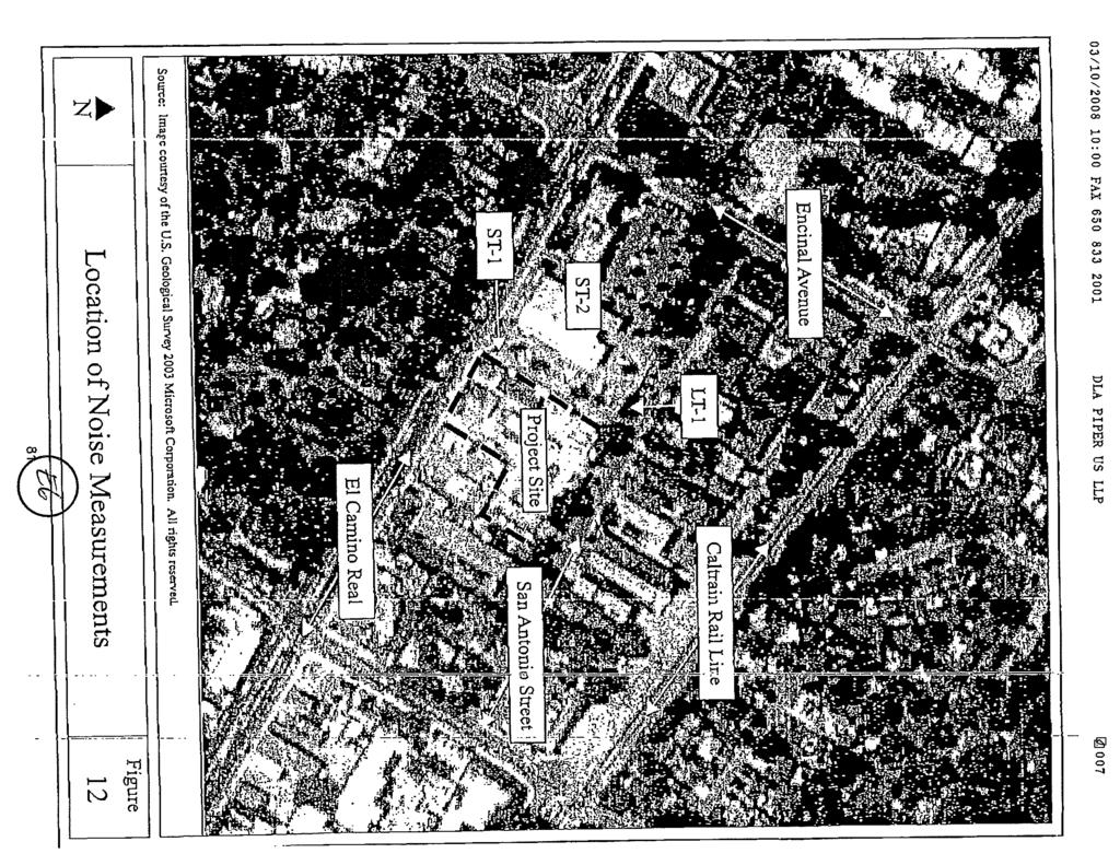
54
55
56
57
58
59
60
61
62
63
64

65
PLANNING COMMISSION STAFF REPORT. Merrimac PLNSUB Planned Development 38 West Merrimac November 9, Request. Staff Recommendation
 PLANNING COMMISSION STAFF REPORT Merrimac PLNSUB2011-00374 Planned Development 38 West Merrimac November 9, 2011 Planning and Zoning Division Department of Community and Economic Development Applicant:
Community Development
 Community Development STAFF REPORT Planning Commission Meeting Date: 7/17/2017 Staff Report Number: 17-047-PC Public Hearing: Use Permit/Alan Coon/989 El Camino Real Recommendation Staff recommends that
CITY OF SIGNAL HILL SUBJECT: PUBLIC HEARING THE COURTYARD RESIDENTIAL DEVELOPMENT OF 10 CONDOMINIUMS AND A NEW SPECIFIC PLAN
 CITY OF SIGNAL HILL 2175 Cherry Avenue Signal Hill, CA 90755-3799 AGENDA ITEM TO: FROM: HONORABLE CHAIR AND MEMBERS OF THE PLANNING COMMISSION SELENA ALANIS ASSOCIATE PLANNER SUBJECT: PUBLIC HEARING THE
SUBJECT: CONSIDERATION OF CENTRAL PARK VILLAGE BREA ENTITLEMENT DOCUMENTS FOR A PROPOSED MIXED USE PROJECT AT W.
 City of Brea Agenda Item: 18 COUNCIL COMMUNICATION Date: July 17, 2012 TO: FROM: Honorable Mayor and City Council City Manager SUBJECT: CONSIDERATION OF CENTRAL PARK VILLAGE BREA ENTITLEMENT DOCUMENTS
Community Development
 Community Development STAFF REPORT Housing Commission Meeting Date: 7/11/2018 Staff Report Number: 18-013-HC Regular Business: Review and provide feedback on potential amendments to the El Camino /Downtown
CITY OF BELMONT MEMORANDUM. September 20, 2016 Planning Commission Meeting - Agenda Item 4B
 CITY OF BELMONT MEMORANDUM TO: FROM: VIA: SUBJECT: Planning Commission Brian Dong, Associate Engineer Carlos de Melo, Community Development Director September 20, 2016 Planning Commission Meeting - Agenda
CITY OF RIO VISTA PLANNING COMMISSION STAFF REPORT
 MEETING DATE: January10, 2018 CITY OF RIO VISTA PLANNING COMMISSION STAFF REPORT AGENDA ITEM #4.2 PREPARED BY: Lamont Thompson, Planning Manager SUBJECT: Vesting Tentative Tract No. 2017-001: To consider
ADMINISTRATIVE STAFF REPORT 5.1
 ADMINISTRATIVE STAFF REPORT 5.1 DATE: January 24, 2017 ITEM: RECOMMENDATION: NOTIFICATION: PROPOSAL: DEV16-0014 - Danville Office Partners, LLC Approve Final Development Plan request DEV16-0014 subject
City of Falls Church Planning Commission Public Hearing
 City of Falls Church Planning Commission Public Hearing Meeting Date: 12-7-15 Title: Variance application V1573-15 by Tim Luwis, a variance to Sec. 48-1004 to allow a 30 percent reduction in the required
ARTICLE 14 PLANNED UNIT DEVELOPMENT (PUD) DISTRICT
 DISTRICT") ARTICLE 14 PLANNED UNIT DEVELOPMENT (PUD) DISTRICT Section 14.01 Intent. It is the intent of this Article to allow the use of the planned unit development (PUD) process, as authorized by the Michigan Zoning
ARTICLE 14 PLANNED UNIT DEVELOPMENT (PUD) DISTRICT Section 14.01 Intent. It is the intent of this Article to allow the use of the planned unit development (PUD) process, as authorized by the Michigan Zoning
Staff Report PLANNED DEVELOPMENT. Salt Lake City Planning Commission. From: Lauren Parisi, Associate Planner; Date: December 14, 2016
 Staff Report PLANNING DIVISION COMMUNITY & NEIGHBORHOODS To: Salt Lake City Planning Commission From: Lauren Parisi, Associate Planner; 801-535-7932 Date: December 14, 2016 Re: 1611 South 1600 East PLANNED
PLANNED UNIT DEVELOPMENTS (Ordinance No.: 3036, 12/3/07; Repealed & Replaced by Ordinance No.: 4166, 10/15/12)
") 159.62 PLANNED UNIT DEVELOPMENTS (Ordinance No.: 3036, 12/3/07; Repealed & Replaced by Ordinance No.: 4166, 10/15/12) A. PURPOSE 1. General. The Planned Unit Development (PUD) approach provides the flexibility
159.62 PLANNED UNIT DEVELOPMENTS (Ordinance No.: 3036, 12/3/07; Repealed & Replaced by Ordinance No.: 4166, 10/15/12) A. PURPOSE 1. General. The Planned Unit Development (PUD) approach provides the flexibility
Staff Report for Council Public Meeting
 Agenda Item 3.3 Staff Report for Council Public Meeting Date of Meeting: September 27, 2017 Report Number: SRPRS.17.134 Department: Division: Subject: Planning and Regulatory Services Development Planning
PLANNING COMMISSION STAFF REPORT
 OFFICE OF COMMUNITY DEVELOPMENT CITY HALL 10300 TORRE AVENUE CUPERTINO, CA 95014-3255 (408) 777-3308 FAX (408) 777-3333 planning@cupertino.org PLANNING COMMISSION STAFF REPORT Agenda Item No. Agenda Date:
TOWN OF LOS ALTOS HILLS January 11, 2018 Staff Report to the Planning Commission
 ITEM #3.2 TOWN OF LOS ALTOS HILLS Staff Report to the Planning Commission SUBJECT: FROM: REQUEST FOR APPROVAL OF A CONDITIONAL DEVELOPMENT AND SITE DEVELOPMENT PERMITS FOR A NEW 2,831 SQUARE FOOT, TWO
RECOMMENDATION REPORT
 DEPARTMENT OF CITY PLANNING RECOMMENDATION REPORT City Planning Commission Date: August 27, 2009 Time: After 8:30 AM Place: City Hall 200 North Spring Street Los Angeles, CA 90012 Public Hearing: Completed
A GUIDE TO PROCEDURES FOR: SUBDIVISIONS & CONDOMINIUM CONVERSION
 A GUIDE TO PROCEDURES FOR: SUBDIVISIONS & CONDOMINIUM CONVERSION A GUIDE TO PROCEDURES FOR: SUBDIVISIONS (TENTATIVE MAPS) PURPOSE Definition: A subdivision is defined as the division of any improved or
PLANNING COMMISSION MAY 3, 2018 PUBLIC HEARING
 PLANNING COMMISSION MAY 3, 2018 PUBLIC HEARING SUBJECT: REQUEST TO DEMOLISH TWO SINGLE-FAMILY DWELLINGS ON TWO ADJOINING LOTS AND CONSTRUCT TEN RESIDENTIAL CONDOMINIUM UNITS AT 947 GENESEE AVENUE AND 944
Members of the Public in attendance are asked to be recognized by the Mayor before participating in any discussions of the Town Board AGENDA
 TOWN BOARD WORK SESSION August 27, 2018 // 5:30 p.m. // First floor conference room 301 Walnut Street, Windsor, CO 80550 GOAL of this Work Session is to have the Town Board receive information on topics
DEVELOPMENT DEPARTMENT STAFF REPORT DRESDEN HEIGHTS PHASE II DCI
 DEVELOPMENT DEPARTMENT Meeting Date: January 10, 2019 Item #: PZ2019-393 Project Name: Applicant and Owner: Proposed Development: Requests: STAFF REPORT DRESDEN HEIGHTS PHASE II DCI Dresden Heights Phase
AGENDA ITEM K3 Community Development
 AGENDA ITEM K3 Community Development STAFF REPORT City Council Meeting Date: 4/17/2018 Staff Report Number: 18-079-CC Regular Business: Complete the biennial review of the El Camino /Downtown Specific
DEVELOPMENT DEPARTMENT STAFF REPORT THE PARK AT 5 TH
 DEVELOPMENT DEPARTMENT STAFF REPORT ARB Meeting Date: July 3, 2018 Item #: _PZ2018-293_ THE PARK AT 5 TH Request: Site Address: Project Name: Parcel Number: Applicant: Proposed Development: Current Zoning:
Community Development Department
 Community Development Department SUBJECT: Reconsideration of Final Site Plan Review, Preliminary Subdivision, and Planned Development for Park Place Glenview at 1225 Waukegan Road MEETING DATE: March 28,
PLANNING COMMISSION AGENDA REPORT ADDENDUM AUGUST 14, Members of the Planning Commission
 PLANNING COMMISSION AGENDA REPORT ADDENDUM AUGUST 14, 2008 TO: FROM: Members of the Planning Commission Maureen Tamuri, Community Development Director Tom Bartlett, AICP, City Planner Glenn Michitsch,
PLANNED UNIT DEVELOPMENT (PUD) AREA PLAN/REZONING REVIEW PROCEDURE
 AREA PLAN/REZONING REVIEW PROCEDURE") PLANNED UNIT DEVELOPMENT (PUD) AREA PLAN/REZONING REVIEW PROCEDURE Professional inquiries will be made to our Township Planning Consultant, Township Engineer, and Township Attorney to get their opinions
PLANNED UNIT DEVELOPMENT (PUD) AREA PLAN/REZONING REVIEW PROCEDURE Professional inquiries will be made to our Township Planning Consultant, Township Engineer, and Township Attorney to get their opinions
Section 1: US 19 Overlay District
 Section 1: US 19 Overlay District Section 1.1 Intent and Purpose The purpose of the US Highway 19 Overlay District is to manage access to land development along US Highway 19 in a manner that preserves
COMMUNITY DEVELOPMENT DEPARTMENT
 AGENDA ITEM I-1 COMMUNITY DEVELOPMENT DEPARTMENT Council Meeting Date: June 3, 2014 Agenda Item #: I-1 INFORMATIONAL ITEM: Update on Multi-City Affordable Housing Nexus Study and Impact Fee Feasibility
Larimer County Planning Dept. Procedural Guide for 1041 PERMITS
 - Larimer County Planning Dept. Procedural Guide for 1041 PERMITS PLEASE NOTE: A PRE-APPLICATION CONFERENCE IS REQUIRED PRIOR TO SUBMITTING THIS APPLICATION. PURPOSE: State Statutes allow local governments
ARTICLE 24 SITE PLAN REVIEW
 ARTICLE 24 SITE PLAN REVIEW 24.1 PURPOSE: The intent of these Ordinance provisions is to provide for consultation and cooperation between the land developer and the Township Planning Commission in order
ZONING & LAND USE APPLICATION
 City of Maple Plain 5050 Independence St P.O. Box 97 Maple Plain, MN 55359 Office: (763) 479-0515 Fax: (763) 479-0519 ZONING & LAND USE APPLICATION APPLICANT INFORMATION Applicant Name Company, if applicable
ARLINGTON COUNTY, VIRGINIA
 ARLINGTON COUNTY, VIRGINIA County Board Agenda Item Meeting of April 19, 2008 DATE: April 2, 2008 SUBJECT: ORDINANCE TO AMEND, REENACT, AND RECODIFY Section 20 CP- FBC, Columbia Pike Form Based Code Districts
4.2 LAND USE INTRODUCTION
 4.2 LAND USE INTRODUCTION This section of the EIR addresses potential impacts from the Fresno County General Plan Update on land use in two general areas: land use compatibility and plan consistency. Under
9. REZONING NO Vicinity of the northwest corner of 143 rd Street and Metcalf Avenue
 9. REZONING NO. 2002-15 Vicinity of the northwest corner of 143 rd Street and Metcalf Avenue 1. APPLICANT: Andrew Schlagel is the applicant for this request. 2. REQUESTED ACTION: The applicant is requesting
City of Lake Elmo Planning Commission Meeting Minutes of January 14, 2013
 City of Lake Elmo Planning Commission Meeting Minutes of January 14, 2013 Chairman Williams called to order the workshop of the Lake Elmo Planning Commission at 7:00pm COMMISSIONERS PRESENT: Fliflet, Obermueller,
Proposed Urban Village (San Juan Hotel & Villas)
") Proposed Urban Village (San Juan Hotel & Villas) City Council 1 Esslinger Building & Judge Egan House These two properties would be substantially preserved in their existing condition and adaptive re use
Proposed Urban Village (San Juan Hotel & Villas) City Council 1 Esslinger Building & Judge Egan House These two properties would be substantially preserved in their existing condition and adaptive re use
PLANNING COMMISSION REPORT Regular Agenda -Public Hearing Item
 PDP-13-00518 Item No. 3B- 1 PLANNING COMMISSION REPORT Regular Agenda -Public Hearing Item PC Staff Report 2/24/14 ITEM NO. 3B PRELIMINARY DEVELOPMENT PLAN FOR HERE @ KANSAS; 1101 INDIANA ST (SLD) PDP-13-00518:
Initial Project Review
 Pierce County Department of Planning and Land Services, 2401 South 35th Street, Tacoma, WA (253) 798-7037 Initial Project Review Major Amendment to Preliminary Plat: Hawks Ridge Division 1 Application
COMMISSION ACTION FORM SUBJECT: ZONING TEXT AMENDMENT FOR LINCOLN WAY CORRIDOR PLAN DOWNTOWN GATEWAY COMMERCIAL ZONING DISTRICT STANDARDS
 ITEM #: 7 DATE: _02-07-18 COMMISSION ACTION FORM SUBJECT: ZONING TEXT AMENDMENT FOR LINCOLN WAY CORRIDOR PLAN DOWNTOWN GATEWAY COMMERCIAL ZONING DISTRICT STANDARDS BACKGROUND: The Downtown Gateway area
May 21, ACHD Board of Commissioners Stacey Yarrington, Planner II DRH /DRH
 Development Services Department May 21, 2013 TO: FROM: SUBJECT: ACHD Board of Commissioners Stacey Yarrington, Planner II DRH13-00106/DRH13-00108 Executive Summary: This is a design review application
Compatible-Scale Infill Housing (R-2 Zones) Project
 Project") Project Scope: A targeted amendment to the regulations for building bulk/height in the R-2 zones. Objectives: Allow more housing opportunities in the R-2A, R-2D, and R-2M zones, while ensuring the height
Project Scope: A targeted amendment to the regulations for building bulk/height in the R-2 zones. Objectives: Allow more housing opportunities in the R-2A, R-2D, and R-2M zones, while ensuring the height
AN ORDINANCE TO AMEND SECTION OF THE RAPID CITY MUNICIPAL CODE TO ALLOW FOR ADMINISTRATIVE DISSOLUTION OF PLANNED DEVELOPMENTS
 Ordinance No. 6231 AN ORDINANCE TO AMEND SECTION 17.50.050 OF THE RAPID CITY MUNICIPAL CODE TO ALLOW FOR ADMINISTRATIVE DISSOLUTION OF PLANNED DEVELOPMENTS WHEREAS, the City of Rapid City has adopted a
CITY OF MERCED SMALL LOT SINGLE-FAMILY HOME DESIGN GUIDELINES
 CITY OF MERCED SMALL LOT SINGLE-FAMILY HOME DESIGN GUIDELINES Development Services Department Planning and Permitting Adopted August 15, 2005 SMALL LOT SINGLE FAMILY HOME GUIDELINES A. Purpose and Applicability.
Appendix1,Page1. Urban Design Guidelines. Back to Back and Stacked Townhouses. DRAFT September 2017
 Appendix1,Page1 Urban Design Guidelines DRAFT September 2017 Back to Back and Stacked Townhouses Appendix1,Page2 Table of Contents 1 Introduction 1 1.1 Purpose 1 1.2 Urban Design Objectives 1 1.3 Building
PLANNING AND ZONING DEPARTMENT
 Town of Minturn Development Review Process: Guide To Planned Unit Developments (Concept Plan) This guide describes the Planned Unit Development Process. This guide should be utilized in conjunction with
Land Use, Transportation, and Infrastructure Committee of Denver City Council FROM: Scott Robinson, Senior City Planner DATE: December 6, 2018 RE:
 Community Planning and Development Planning Services 201 W. Colfax Ave., Dept. 205 Denver, CO 80202 p: 720.865.2915 f: 720.865.3052 www.denvergov.org/cpd TO: Land Use, Transportation, and Infrastructure
Director, Community Planning, Toronto and East York District
 STAFF REPORT September 1, 2005 To: From: Subject: Toronto and East York Community Council Director, Community Planning, Toronto and East York District Further Report Applications to amend Official Plan
CITY COUNCIL PUBLIC HEARING MARCH 20, 2017 SUBJECT:
 CITY COUNCIL PUBLIC HEARING MARCH 20, 2017 SUBJECT: INITIATED BY: APPEAL OF THE PLANNING COMMISSION APPROVAL OF A REQUEST TO EXPAND AN EXISTING RESTAURANT WITHIN THE EXISTING LOBBY AND ROOFTOP AREA WITH
LAND USE PROCEDURES (LUP) BYLAW NO. 1235, 2007
 BYLAW NO. 1235, 2007") TOWN OF OSOYOOS LAND USE PROCEDURES (LUP) BYLAW NO. 1235, 2007 Adopted August 13, 2007 PART 1 PART 2 PART 3 PART 4 PART 5 PART 6 PART 7 PART 8 TABLE OF CONTENTS Index provided for ease of use and was not
TOWN OF OSOYOOS LAND USE PROCEDURES (LUP) BYLAW NO. 1235, 2007 Adopted August 13, 2007 PART 1 PART 2 PART 3 PART 4 PART 5 PART 6 PART 7 PART 8 TABLE OF CONTENTS Index provided for ease of use and was not
Guidelines for the Approval of New Homes Sales Offices (Building Permits, Agreements, Securities)
") Guidelines for the Approval of New Homes Sales Offices (Building Permits, Agreements, Securities) ENCLOSURES: Site Plan Application Building Permit Application Grading and Drainage Approval Requirements
Guidelines for the Approval of New Homes Sales Offices (Building Permits, Agreements, Securities) ENCLOSURES: Site Plan Application Building Permit Application Grading and Drainage Approval Requirements
Financial Impact Statement There are no immediate financial impacts associated with the adoption of this report.
 STAFF REPORT Planning and Development Department Subject: Application by RYC Property to rezone a portion of lands on John Murray Dr. and Megan Lynn Dr. from R2 to R3 and to enter into a Development Agreement
Staff Report. Street Vacation. Salt Lake City Planning Commission. Ashley Scarff, (801) or Date: April 10 th, 2019
 or Date: April 10 th, 2019") Staff Report PLANNING DIVISION DEPARTMENT of COMMUNITY & NEIGHBORHOODS To: From: Salt Lake City Planning Commission Ashley Scarff, (801) 535-7660 or ashley.scarff@slcgov.com Date: April 10 th, 2019 Re:
Staff Report PLANNING DIVISION DEPARTMENT of COMMUNITY & NEIGHBORHOODS To: From: Salt Lake City Planning Commission Ashley Scarff, (801) 535-7660 or ashley.scarff@slcgov.com Date: April 10 th, 2019 Re:
REPORT TO PLANNING AND DESIGN COMMISSION City of Sacramento
 REPORT TO PLANNING AND DESIGN COMMISSION City of Sacramento 915 I Street, Sacramento, CA 95814-2671 www.cityofsacramento.org 9 PUBLIC HEARING December 10, 2015 To: Members of the Planning and Design Commission
ZONING AMENDMENT & SUBDIVISION STAFF REPORT Date: November 3, 2016
 ZONING AMENDMENT & SUBDIVISION STAFF REPORT Date: November 3, 2016 APPLICANT NAME SUBDIVISION NAME David Shumer 5955 Airport Subdivision CITY COUNCIL DISTRICT District 6 5955 Airport Boulevard, 754 Linlen
PLANNED UNIT DEVELOPMENT STAFF REPORT Date: October 19, 2017
 PLANNED UNIT DEVELOPMENT STAFF REPORT Date: October 19, 2017 DEVELOPMENT NAME LOCATION Custom Boat Storage 3975 Demetropolis Road (East side of Demetropolis Road, 0.2± miles South of Halls Mill Road.)
O-I (Office-Institutional) and AG-1(Agricultural)
 and AG-1(Agricultural)") PROPERTY INFORMATION ADDRESS 3503 and 3505 Bethany Bend DISTRICT, LAND LOTS 2/1 973 and 974 OVERLAY DISTRICT State Route 9 PETITION NUMBERS EXISTING ZONING O-I (Office-Institutional) and AG-1(Agricultural)
PROPERTY INFORMATION ADDRESS 3503 and 3505 Bethany Bend DISTRICT, LAND LOTS 2/1 973 and 974 OVERLAY DISTRICT State Route 9 PETITION NUMBERS EXISTING ZONING O-I (Office-Institutional) and AG-1(Agricultural)
CITY OF VAUGHAN EXTRACT FROM COUNCIL MEETING MINUTES OF DECEMBER 11, 2012
 Item 6, Report No. 50, of the Committee of the Whole (Public Hearing), which was adopted, as amended, by the Council of the City of Vaughan December 11, 2012, as follows: By receiving Communication C1
CHAPTER SUBDIVISION MAPS
 CHAPTER 19.66 SUBDIVISION MAPS SUBDIVISION MAPS 19.66 Section Page 19.66.010 Purpose... IV-56 19.66.020 Application... IV-57 19.66.030 Exclusions... IV-57 19.66.040 Effect of Annexation... IV-57 19.66.050
Update on the Avenues and Mid-Rise Buildings Action Plan
 STAFF REPORT INFORMATION ONLY Update on the Avenues and Mid-Rise Buildings Action Plan Date: May 15, 2009 To: From: Wards: Reference Number: Planning and Growth Management Committee Chief Planner and Executive
City-Initiated Study for the West Side of Roncesvalles Avenue, Between Marmaduke Street and Marion Street Final Report
 STAFF REPORT ACTION REQUIRED City-Initiated Study for the West Side of Roncesvalles Avenue, Between Marmaduke Street and Marion Street Final Report Date: November 22, 2013 To: From: Wards: Reference Number:
Yonge Street and 3 Gerrard Street East - Zoning Amendment Application - Preliminary Report
 STAFF REPORT ACTION REQUIRED 363-391 Yonge Street and 3 Gerrard Street East - Zoning Amendment Application - Preliminary Report Date: May 22, 2015 To: From: Wards: Reference Number: Toronto and East York
Acting General Manager of Planning and Development Services and the Director of Legal Services
 POLICY REPORT DEVELOPMENT AND BUILDING Report Date: January 11, 2016 Contact: Jane Pickering Contact No.: 604.873.7456 RTS No.: 11254 VanRIMS No.: 08-2000-20 Meeting Date: January 19, 2016 TO: FROM: SUBJECT:
City of Colleyville City Council Agenda Briefing
 City of Colleyville City Council Agenda Briefing City Hall 100 Main Street Colleyville, Texas 76034 www.colleyville.com Agenda Number 5a Agenda Date 01/06/2015 Number Ordinance O-14-1942 Type Ordinance
Courtyards at Kinnamon Park Sketch Plan
 Courtyards at Kinnamon Park Sketch Plan Courtyards at Kinnamon Park Sketch Plan Staff Analysis PART 1: PROJECT SUMMARY Applicant: EPCON Communities Property Owner: Johnsie M. Kinnamon Heirs, Douglas and
HISTORIC PRESERVATION BOARD BOARD AGENDA
 HISTORIC PRESERVATION BOARD BOARD AGENDA Historic Preservation Board Regular Meeting - Monday, November 24, 2014-6:00 p.m. City Hall - City Commission Chambers, 100 North U.S. #1, Fort Pierce, Florida
ARLINGTON COUNTY, VIRGINIA
 ARLINGTON COUNTY, VIRGINIA County Board Agenda Item Meeting of September 18, 2004 DATE: August 19, 2004 SUBJECTS: A. GP-297-04-1 GENERAL LAND USE PLAN AMENDMENT from Service Commercial (Personal and business
Draft Model Access Management Overlay Ordinance
 Draft Model Access Management Overlay Ordinance This model was developed using the City of Hutchinson and the Trunk Highway 7 corridor. The basic provisions of this model may be adopted by any jurisdiction
Napa County Planning Commission Board Agenda Letter
 Agenda Date: 9/20/2017 Agenda Placement: 8C Napa County Planning Commission Board Agenda Letter TO: FROM: Napa County Planning Commission Charlene Gallina for David Morrison - Director Planning, Building
Chapter 2.60 RECOGNIZED COMMUNITY ORGANIZATIONS
 Draft ordinance: underlined text is proposed to be added. Strikethrough text is proposed to be deleted. Chapter 2.60 RECOGNIZED COMMUNITY ORGANIZATIONS 2.60.010: PURPOSE: 2.60.020: DEFINITION: 2.60.030:
M E M O R A N D U M. Meeting Date: April 19, Item No. H-2. Mark Hafner, City Manager. Michele Berry, Planner II
 M E M O R A N D U M Meeting Date: April 19, 2016 Item No. H-2 To: From: Subject: Mark Hafner, City Manager Michele Berry, Planner II PUBLIC HEARING: Consider an ordinance approving a Specific Use Permit
CITY OF VAUGHAN POLICY AND PROCEDURES FOR DEALING WITH CONTAMINATED OR POTENTIALLY CONTAMINATED SITES
 CITY OF VAUGHAN POLICY AND PROCEDURES FOR DEALING WITH CONTAMINATED OR POTENTIALLY CONTAMINATED SITES MAY 2001 This Report should be read in conjunction with the City of Vaughan BACKGROUND REPORT ON POLICY
City of Independence
 City of Independence Request for a Text Amendment to the Zoning Ordinance to Allow Solar Gardens in the AG-Agriculture Zoning District To: From: Planning Commission Mark Kaltsas, City Planner Meeting Date:
Application Procedures for Easements or Rights of Way on City of Fort Collins Natural Areas and Conserved Lands March 2012
 Application Procedures for Easements or Rights of Way on City of Fort Collins Natural Areas and Conserved Lands March 2012 IMPORTANT NOTE: This document was created to accompany the City of Fort Collins
CHAPTER XVIII SITE PLAN REVIEW
 CHAPTER XVIII SITE PLAN REVIEW Section 18.1 Section 18.2 Description and Purpose. The purpose of this chapter is to provide standards and procedures under which applicants would submit, and the Township
Town Centre Community Improvement Plan
 2012 Town Centre Community Improvement Plan City of Greater Sudbury Growth and Development Department 1.0 PLAN BACKGROUND 1.1 Introduction The following Community Improvement Plan (CIP) has been prepared
ARLINGTON COUNTY, VIRGINIA. County Board Agenda Item Meeting of September 19, 2015
 ARLINGTON COUNTY, VIRGINIA County Board Agenda Item Meeting of September 19, 2015 DATE: August 28, 2015 SUBJECT: Request to authorize advertisement of public hearings by the Planning Commission and the
Operating Standards Attachment to Development Application
 Planning & Development Services 2255 W Berry Ave. Littleton, CO 80120 Phone: 303-795-3748 Mon-Fri: 8am-5pm www.littletongov.org Operating Standards Attachment to Development Application 1 PLANNED DEVELOPMENT
ARTICLE 3: Zone Districts
 ARTICLE 3: Zone Districts... 3-1 17.3.1: General...3-1 17.3.1.1: Purpose and Intent... 3-1 17.3.2: Districts and Maps...3-1 17.3.2.1: Applicability... 3-1 17.3.2.2: Creation of Districts... 3-1 17.3.2.3:
M E M O. September 14, 2017 Agenda Item #4. Planning Commission. David Goodison, Planning Director
 September 14, 2017 Agenda Item #4 M E M O To: From: Planning Commission David Goodison, Planning Director Re: Preliminary review of an application for a mixed-use development proposed for 870 Broadway
Date to Committee: October 13, 2015 Date to Council: November 2, 2015
 Page 1 of Report PB-76-15 TO: FROM: Development and Infrastructure Committee Planning and Building SUBJECT: Statutory public meeting and information report regarding 1371975 Ontario Inc. (Markay Homes)
A. Land Use Designations: General Plan: Single-Family Residential Zoning: R-1H, Single-Family Residential, Hillside District
 Z O N I N G A D J U S T M E N T S B O A R D S t a f f R e p o r t FOR BOARD ACTION SEPTEMBER 9, 2010 2956 Shasta Road Appeal of the Zoning Officer s decision to approve Administrative Use Permit #09-20000088
Chapter 22 PLANNED UNIT DEVELOPMENT.
 Chapter 22 PLANNED UNIT DEVELOPMENT. Sec. 22.1 INTENT. The use of land and the construction and use of buildings and other structures as Planned Unit Developments in Georgetown Township may be established
CITY OF PISMO BEACH PLANNING COMMISSION AGENDA REPORT
 CITY OF PISMO BEACH PLANNING COMMISSION AGENDA REPORT DATE: October 27, 2015 TO: FROM: HONORABLE CHAIR AND MEMBERS OF THE PLANNING COMMISSION Jan Di Leo, Planner (805) 773-7088 jdileo@pismobeach.org APPLICATION:
Planning Commission Report
 cjly City of Beverly Hills Planning Division 455 N. Rexford Drive Beverly Hills, CA 90210 TEL. (310) 285-1141 FAX. (370) 858-5966 Planning Commission Report Meeting Date: April 28, 2016 Subject: Project
MARIN COUNTY BOARD OF SUPERVISORS RESOLUTION
 MARIN COUNTY BOARD OF SUPERVISORS RESOLUTION A RESOLUTION DENYING THE LUCAS VALLEY ESTATES HOMEOWNERS ASSOCIATION APPEAL AND SUSTAINING THE PLANNING COMMISSION S DECISION TO CERTIFY THE GRADY RANCH PRECISE
Summary of Presentation and Q&A from January 19, 2016
 Parkmerced Vision Update Resident Meeting, Q&A Portion January 19, 2016 Summary of Presentation and Q&A from January 19, 2016 The following is a summary of resident comments and suggestions noted during
Presentation. Agenda Item # 1. Meeting Date February 3, Erkin Ozberk, Planner. Prepared By. Brian T. Kenner City Manager.
 Agenda Item # 1 Presentation Meeting Date February 3, 2014 Prepared By Approved By Erkin Ozberk, Planner Brian T. Kenner City Manager Discussion Item Background Update on Montgomery County s Zoning Code
Butte County Board of Supervisors
 Butte County Board of Supervisors PUBLIC HEARING January 12, 2016 Amendments to the General Plan and Zoning Ordinance AG-P5.3 (Agricultural Buffer) and Interim Agricultural Uses Butte County Department
sdci 201 Seattle Permits Tip Master Use Permit (MUP) Overview What is Seattle's Framework for Land Use Decisions?
 Overview What is Seattle's Framework for Land Use Decisions?") sdci Seattle Department of Construction and Inspections Tip 201 Seattle Permits part of a multi-departmental City of Seattle series on getting a permit Master Use Permit (MUP) Overview June 2, 2011 This
sdci Seattle Department of Construction and Inspections Tip 201 Seattle Permits part of a multi-departmental City of Seattle series on getting a permit Master Use Permit (MUP) Overview June 2, 2011 This
Application for Sketch Plan Review
 Town of Standish 175 Northeast Road Standish, ME - 04084 Phone: (207)642-3461 Fax: (207) 642-5181 Application for Sketch Plan Review Applicant & Owner Information 1) Name of Applicant: Address: Phone:
Item 10C 1 of 69
 MEETING DATE: August 17, 2016 PREPARED BY: Diane S. Langager, Principal Planner ACTING DEPT. DIRECTOR: Manjeet Ranu, AICP DEPARTMENT: Planning & Building CITY MANAGER: Karen P. Brust SUBJECT: Public Hearing
ARLINGTON COUNTY, VIRGINIA
 ARLINGTON COUNTY, VIRGINIA County Board Agenda Item Meeting of April 25, 2009 DATE: April 14, 2009 SUBJECTS: A. Amendments to the Arlington County Zoning Ordinance, Section 20. (Appendix A), CP-FBC Columbia
PLANNING & COMMUNITY DEVELOPMENT DEPARTMENT STAFF REPORT KELVIN PARKER, PRINCIPAL PLANNER/ZONING ADMINISTRATOR
 DATE: JUNE 21, 2017 PLANNING & COMMUNITY DEVELOPMENT DEPARTMENT STAFF REPORT TO: FROM: BOARD OF ZONING APPEALS KELVIN PARKER, PRINCIPAL PLANNER/ZONING ADMINISTRATOR SUBJECT: APPEAL OF HEARING OFFICER S
DENTON Developer's Handbook
 DENTON Developer's Handbook A guide for land development in the City of Denton Department of Development Services 2017 2 Table of Contents 1. City of Denton Development Process...5 Role of the Development
PLANNING & COMMUNITY DEVELOPMENT DEPARTMENT STAFF REPORT
 PLANNING & COMMUNITY DEVELOPMENT DEPARTMENT STAFF REPORT DATE: TO: Hearing Officer SUBJECT: Minor Variance #11876 LOCATION: APPLICANT: ZONING DESIGNATION: GENERAL PLAN DESIGNATION: CASE PLANNER: STAFF
Staff recommends the City Council hold a public hearing, listen to all pertinent testimony, and introduce on first reading:
 CITY COUNCIL PUBLIC HEARING JANUARY 16, 2018 SUBJECT: INITIATED BY: MULTI-FAMILY NEIGHBORHOODS ZONE TEXT AMENDMENTS: AMEND MINIMUM DENSITY REQUIREMENTS FOR R3 AND R4 DISTRICTS; AMEND THE DENSITY BONUS
LAND USE AND ZONING OVERVIEW
 OVERVIEW OF PLANNING POLICIES LAND USE AND ZONING OVERVIEW The Minneapolis Plan for Sustainable Growth and Other Adopted Plans Community Planning and Economic Development Development Services Division
L L O T DESIGN GUIDELINES. Appendices
 S M AL L L O T DESIGN GUIDELINES Appendices APPENDIX A VENICE SPECIFIC PLAN VERIFICATION The community of Venice has a refined set of small lot guidelines that are based on the Venice Coastal Specific
1. APPLICANT: Polsinelli, Shalton & Welte is the applicant for this request.
 5. REVISED PRELIMINARY PLAN APPROVAL - THE RETREAT AT MAPLECREST - Vicinity of the northeast corner of 159 th Street and U.S. 69 Highway 1. APPLICANT: Polsinelli, Shalton & Welte is the applicant for this
II. What Type of Development Requires Site Plan Review? There are five situations where a site plan review is required:
 I. What is a Site Plan Review? Site Plan Review is a process where the construction of new buildings, new additions, and certain types of canopies and/or tax-exempt institutions are reviewed by the City
1. The reason provided for the opposing votes was that the two commissioners wanted something else to be developed on their parcel.
 Agenda Item #6.2 SUBJECT: PUBLIC HEARING - APPEAL OF PLANNING COMMISSION DECISION DENYING THE APPROVAL OF THE TENTATIVE PARCEL MAP, CONDITIONAL USE PERMIT, AND SITE AND ARCHITECTURAL REVIEW FOR THE CONSTRUCTION