REDEVELOPMENT PLAN FOR THE TRANSBAY REDEVELOPMENT PROJECT AREA
|
|
|
- Sheena Hampton
- 6 years ago
- Views:
Transcription
1 REDEVELOPMENT PLAN FOR THE TRANSBAY REDEVELOPMENT PROJECT AREA Amended Redevelopment Plan Adopted and Approved by the Board of Supervisors of the City and County of San Francisco Ordinance No , April 28, 2016
2
3 REDEVELOPMENT PLAN FOR THE TRANSBAY REDEVELOPMENT PROJECT AREA Originally Adopted and Approved by The Board of Supervisors of the City and County of San Francisco, Ordinance No , June 21, 2005 And Ordinance No , May 9, 2006 And Ordinance No , June 16, 2015 Amended and Approved by The Board of Supervisors of the City and County of San Francisco, Ordinance No , April 28, 2016
4
5 TABLE OF CONTENTS CHAPTER 1.0 INTRODUCTION Contents of the Plan Conformance with the General Plan Preliminary Plan Agency Powers, Duties and Obligations for Implementation of Plan Project Area Boundaries and Legal Description Definitions Related Plan Documents... 5 CHAPTER 2.0 GOALS AND OBJECTIVES Redevelopment Project Objectives Planning Goals and Objectives... 9 A. Pedestrian Environment... 9 B. Transportation and Parking... 9 C. Open Space and Neighborhood Amenities D. Community Identity and Built Form E. Housing Opportunities F. Office and Hotel Development G. Transbay Terminal CHAPTER 3.0 LAND USES PERMITTED IN THE PROJECT AREA General Controls and Limitations Redevelopment Zoning Map Permitted Land Uses Transbay Downtown Residential (Zone One) Transbay C-3 (Zone Two) Number of Dwelling Units Other Land Uses Transbay Terminal Public Rights-of-Way Open Space, Public and Semi-Public Uses Interim Uses Nonconforming Uses Zone One Plan Map... 16
6 3.5 Zone One Development Plan Open Space and Street Layout Height and Size of Buildings Type and Number of Buildings Development Controls and Design Guidelines Variations Administration of Development Controls CHAPTER 4.0 PROPOSED REDEVELOPMENT ACTIVITIES Redevelopment Actions General Redevelopment Actions Nondiscrimination in the Implementation of Redevelopment Actions Employment and Contracting Opportunities in the Implementation of Redevelopment Actions Participation by Owners and Tenants Opportunities for Owners and Business Tenants Rules for Participation Opportunities, Priorities and Preferences Owner Participation Agreements Conforming Owners Phasing with Development Cooperation with Public Bodies Property Acquisition Real Property Personal Property Relocation of Persons, Business Concerns and Others Displaced by Project Assistance in Finding Other Locations Demolition, Clearance, Public Improvements and Building and Site Preparation Demolition and Clearance Public Improvements, Public Facilities and Public Utilities Preparation of Building Sites Property Disposition and Development Real Property Disposition and Development Property Acquired Pursuant to Option Agreement Disposition and Development Documents Development by the Agency Development Plans Personal Property Disposition Rehabilitation, Conservation and Moving of Structures Rehabilitation and Conservation Moving of Structures Low- and Moderate- Income Housing Replacement Housing Affordable Housing Production On-Site Affordable Housing Requirement Increased and Improved Housing Supply... 28
7 CHAPTER 5.0 METHODS OF FINANCING THE PLAN General Description of Proposed Financing Method Tax Increment Funds Agency Bonds Time Limit on Establishment of Indebtedness Time Limit for Receipt of Tax Increment Funds Other Loans, Grants and Miscellaneous Financing Sources Pledge of State Parcel Net Tax Increment to Transbay Joint Powers Authority Exactions Downtown Park Special Fund Jobs-Housing Linkage Program Other Exactions CHAPTER 6.0 ACTIONS, ENFORCEMENT AND PROCEDURES Actions by the City and County Administration and Enforcement Duration and Effectiveness of the Plan Procedures for Plan Amendment Severability EXHIBIT 1: REDEVELOPMENT BOUNDARY MAP EXHIBIT 2: LEGAL DESCRIPTION OF PROJECT AREA BOUNDARIES EXHIBIT 3: REDEVELOPMENT ZONING MAP EXHIBIT 4: ZONE ONE PLAN MAP...40 EXHIBIT 5: PROPOSED PUBLIC IMPROVEMENTS... 41
8
9 CHAPTER 1.0 INTRODUCTION 1.1 Contents of the Plan This Redevelopment Plan (the Plan ) for the Transbay Redevelopment Project (the Project ) in the City and County of San Francisco (the City ) consists of text, the Redevelopment Boundary Map (attached as Exhibit No. 1), the Legal Description of Project Area Boundaries (attached as Exhibit No. 2), the Redevelopment Land Use Map (attached as Exhibit No. 3), the Zone One Plan Map (attached as Exhibit No. 4) and the Proposed Public Improvements (attached as Exhibit No. 5). All exhibits are incorporated into the Plan by reference. This Plan was prepared by the San Francisco Redevelopment Agency (the Agency ) pursuant to the Community Redevelopment Law of the State of California (Health & Safety Code et seq.) (the Redevelopment Law ), the California Constitution, and all applicable local codes and ordinances. The area covered by this Plan is referred to as the Transbay Redevelopment Project Area (the Project Area ). The Project Area includes all properties within the Project boundary shown on the Redevelopment Boundary Map. 1.2 Conformance with the General Plan The proposed redevelopment of the Project Area as described in this Plan is consistent with the General Plan of the City and County of San Francisco, and all rehabilitation and new development will comply with the Transbay Development Controls and Design Guidelines, the General Plan, the Planning Code and any other applicable ordinances as described in Chapter 3.0. The Plan is also intended to supplement but not supplant other laws and regulations applicable within the Project Area, as they may be enacted or amended from time to time. 1.3 Preliminary Plan This Plan is based upon a Preliminary Plan formulated and adopted by the Planning Commission of the City (the Planning Commission ) at its October 10, 1996 hearing in Resolution No and amended by the Planning Commission at its February 22, 2001 hearing in Resolution No and at its April 22, 2004 hearing in Resolution No Agency Powers, Duties and Obligations for Implementation of Plan This Plan provides the Agency with powers, duties and obligations to implement and further the program described herein. This Plan provides a framework within which specific development plans will be devised, priorities for specific projects established, and specific solutions proposed. 1
10 It also describes the tools available to the Agency to develop and proceed with specific plans, projects, and solutions. 1.5 Project Area Boundaries and Legal Description The boundaries of the Project Area are shown on the Redevelopment Boundary Map (attached as Exhibit No. 1) and described in the Legal Description of Project Area Boundaries (attached as Exhibit No. 2). 1.6 Definitions The following definitions are used in this Plan unless otherwise indicated by the text: Agency means the Redevelopment Agency of the City and County of San Francisco, California. Agency Commission means the Redevelopment Commission of the City and County of San Francisco. Board means the Board of Supervisors of the City and County of San Francisco, California. Caltrain Downtown Extension means the extension of Peninsula Corridor, or Caltrain, commuter rail service from 4 th and Townsend Streets to a terminus underneath the new Transbay Terminal. Citizens Advisory Committee or CAC means the advisory body appointed by the Mayor of the City to advise the Agency on the preparation of the Plan and supporting documents such as the Development Controls and Design Guidelines. City means the City and County of San Francisco, California. Community Redevelopment Law or CRL means the Community Redevelopment Law of the State of California ( et seq. of the California Health & Safety Code). Design for Development means a document that establishes conceptual frameworks for land use, urban form, streets and public spaces in the Project Area and that provides non-binding background guidance explaining the purpose and objectives of the Development Controls and Design Guidelines. 2
11 Development Controls and Design Guidelines means a document that establishes mandatory and measurable design specifications applicable to all new construction and suggestions for building features or qualities to be considered in project designs, often requiring subjective analysis, in the Project Area. Federal Government means the United States or any of its agencies or instrumentalities. General Plan means the General Plan for the City and County of San Francisco. Owner Participation Agreement means a binding agreement between a property owner and the Agency, required as a condition to participation in redevelopment, by which the participant agrees to rehabilitate, develop, use and maintain the property in conformance with the Redevelopment Plan and to be subject to its provisions. Peninsula Corridor Joint Powers Board means a joint exercise of powers agency composed of the City and County of San Francisco, San Mateo County Transit District, and Santa Clara Valley Transportation Authority. Plan means the Redevelopment Plan for the Transbay Redevelopment Project. Plan and Method of Relocation means a document that establishes how the Agency shall assist such persons, business concerns and others displaced from the Project Area by redevelopment activities of or assisted by the Agency in finding new locations in accordance with all applicable relocation statutes and regulations. Plan Documents means documents related to the Redevelopment Plan developed by the City or the Agency in order to facilitate the implementation of the Redevelopment Plan, including Development Controls and Design Guidelines, Implementation Plans, and interagency cooperative agreements. Planning Code means the Planning Code of the City and County of San Francisco. Planning Commission means the Planning Commission of the City and County of San Francisco, California. Planning Department means the Department of City Planning of the City and County of San Francisco. Project means the Transbay Redevelopment Project. Project Area means the area included within the boundaries of the Transbay Redevelopment Project. 3
12 Qualified Historical Building has the meaning set forth in Section XXXX of the State Historic Building Code (SHBC) which is any building, structure, object, or collection or grouping thereof and their associated sites and any historic landscapes, which have been designated as important to history, architecture, archaeology or culture of an area by a local, state or federal governmental jurisdiction. This definition includes 1) properties listed in or determined to be eligible for listing in the National Register of Historic Places or the California Register of Historical Resources, or both; 2) properties designated or listed as historically, architecturally or culturally significant, whether individually or as contributing to a geographical or thematic district, under any municipal or county ordinance; 3) properties identified as significant in historical resource surveys, if the survey meets the criteria listed in subdivision (g) of Section of the Public Resources Code; and 4) properties not included in subsections 1 through 3 above, but determined to be historical resources by a lead agency pursuant to and for the purposes of Section of the Public Resources Code. Real Property means land, including land under water and waterfront property; buildings, structures, fixtures, and improvements on the land; any property appurtenant to or used in connection with the land; every estate, interest, privilege, easement, franchise, and right in land, including rights-of-way, terms for years, and liens, charges, or encumbrances by way of judgment, mortgage, or otherwise and the indebtedness secured by such liens. Rules Governing Participation by Property Owners and the Extension of Reasonable Preferences to Business Occupants means a document that establishes how the provisions of the Plan regarding participation by property owners and the extension of reasonable preferences to business occupants will be implemented within the Project Area. These rules set forth the procedures governing such participation and preferences. State means the State of California. State Historical Building Code (SHBC) means the State Historical Building Code as set forth in Part 8 of Title 24 (State Building Standards Code), which applies to all qualified historic structures, districts and sites, designated under federal, state and local authority. It provides building regulations for the rehabilitation, preservation, restoration or relocation of structures designated as qualified historic buildings. Streetscape and Public Open Space Plan means a set of standards and specifications for new public streets, alleys, rights-of-way, sidewalks, intersections, parks, plazas, playgrounds and other public improvements in the Project Area. Terminal Site means the site of the existing Transbay Terminal operated by the State of California Department of Transportation. Transbay Joint Powers Authority means the public entity created by the City and County of San Francisco, the Alameda-Contra Costa County Transit District and the Peninsula Corridor Joint Powers Board on April 4, 2001, to develop, design, construct, renovate, rehabilitate, 4
13 improve, operate, manage and maintain a new regional transit terminal, which shall include the removal of existing structures, which will provide expanded bus and rail service, including the design and construction of the downtown extension of Peninsula Corridor, or Caltrain, commuter rail service from 4 th and Townsend Streets to the new regional transit terminal, and direct access to transit on the Terminal Site and/or property adjacent to the Terminal Site. 1.7 Related Plan Documents In order to facilitate the implementation of this Plan, the City and the Agency may develop related Plan Documents including Development Controls and Design Guidelines, Implementation Plans, and interagency cooperative agreements. In addition, the State or the City may pass legislation related to this Plan. Development Controls and Design Guidelines. Concurrently with the adoption of this Plan, the Agency shall adopt a set of Development Controls and Design Guidelines that establishes height limits of buildings, land coverage, density, street systems, design criteria, parking and loading standards and other development controls and design guidelines that apply to the development of both private and public areas within the Project Area. Implementation Plan. Per Section of the Community Redevelopment Law, the Agency shall adopt, after a public hearing, an implementation plan that shall contain the specific goals and objectives of the Agency for the Project Area, the specific programs, including potential projects, and estimated expenditures proposed to be made during the next five years, and an explanation of how the goals and objectives, programs, and expenditures will eliminate blight within the Project Area and implement the requirements of Sections , , , and of CRL. After adoption of the first implementation plan, the parts of the implementation plan that address CRL Sections , , , and shall be adopted every five years either in conjunction with the City s housing element cycle or the implementation plan cycle. Rules Governing Participation by Property Owners and the Extension of Reasonable Preferences to Business Occupants. The Agency shall adopt, after a public hearing, Rules Governing Participation by Property Owners and the Extension of Reasonable Preferences to Business Occupants. These rules are adopted pursuant to the CRL in order to implement the provisions of the Plan regarding participation by property owners and the extension of reasonable preferences to business occupants within the Project Area. These rules set forth the procedures governing such participation and preferences. The rules encourage and permit participation in the redevelopment of the Project Area by property owners and extend reasonable preferences to business occupants of real property within the boundaries of the Project Area to the maximum extent consistent with the objectives of the Redevelopment Plan. Plan and Method of Relocation. The Agency shall adopt, after a public hearing, a Plan and Method of Relocation that establishes how the Agency shall assist such persons, business 5
14 concerns and others displaced from the Project Area by redevelopment activities of or assisted by the Agency in finding new locations in accordance with all applicable relocation statutes and regulations. Design for Development. The Design for Development is a document that establishes conceptual frameworks for land use, urban form, streets and public spaces in the Project Area and that provides non-binding background guidance explaining the purpose and objectives of the Development Controls and Design Guidelines. The Design for Development was commissioned by the Agency from a consultant team led by Skidmore, Owings & Merrill and published in October Streetscape and Public Open Space Plan. The Agency shall adopt, after a public hearing, a Streetscape and Public Open Space Plan that establishes the locations of and the standards and specifications for new public streets, alleys, rights-of-way, sidewalks, intersections, parks, plazas, playgrounds and other public improvements in the Project Area. California State Assembly Bill No In July 2003, the Governor of California signed legislation approving the demolition of the Transbay Terminal, including its associated ramps, for construction of a new terminal. This legislation also set minimum affordable housing requirements for any redevelopment plan adopted to finance the demolition of the Transbay Terminal and construction of a new terminal. The bill requires that at least twenty-five (25) percent of all new or rehabilitated dwelling units developed within the Project Area shall be available at affordable housing cost to, and occupied by, persons and families whose incomes do not exceed sixty (60) percent of the area median income, and that an additional ten (10) percent of all new or rehabilitated dwelling units developed within the Project Area shall be available at affordable housing cost to, and occupied by, persons and families whose incomes do not exceed one hundred twenty (120) percent of the area median income. Transbay Transit Terminal Cooperative Agreement. The TTT Cooperative Agreement was entered into by the City, the Transbay Joint Powers Authority, and the California Department of Transportation ( Caltrans ) in July The agreement establishes a schedule by which the ownership of the Terminal Site and certain properties around the Terminal Site will be transferred from Caltrans to the City and the Transbay Joint Powers Authority. The agreement also requires that any and all land sale revenue and net tax increment (after the required 20 percent housing set-aside and statutory passthroughs) generated from the transferred properties shall be used for costs associated with the construction and design of the future Transbay Terminal and Caltrain Downtown Extension. Implementation Agreement. The Agency and the Transbay Joint Powers Authority have already entered into a Transbay Redevelopment Project Implementation Agreement, which, among other things, is intended to provide the framework for and facilitate cooperation between the Agency and the TJPA in accordance with the Transbay Redevelopment Plan and other Plan Documents, when they become effective, with respect to the development of the Transbay Terminal and the development of vacant and underutilized parcels in the Project Area. 6
15 Option Agreement. When the Plan becomes effective, the Agency, the City and the Transbay Joint Powers Authority will finalize an Option Agreement, which, among other things, addresses the Agency's option to purchase certain parcels within the Project Area that will be transferred from Caltrans to the City and the Transbay Joint Powers Authority provided that, consistent with the TTT Cooperative Agreement, any and all land sale revenue and net tax increment (after the required 20 percent housing set-aside and statutory passthroughs) generated from the transferred properties shall be used for costs associated with the construction and design of the future Transbay Terminal and Caltrain Downtown Extension. Tax Increment Allocation and Sales Proceeds Pledge Agreement. When the Plan becomes effective, the Agency, the City and the Transbay Joint Powers Authority will finalize a Tax Increment Allocation and Sales Proceeds Pledge Agreement, which, among other things, addresses the provisions of the TTT Cooperative Agreement pertaining to the Agency s pledge of State Parcel Net Tax Increment (defined in the TTT Cooperative Agreement) to the Transbay Joint Powers Authority to pay costs associated with the construction and design of the Transbay Terminal, including access ramps, the temporary terminal facility, railroad extensions and related improvements and facilities. 7
16 CHAPTER 2.0 GOALS AND OBJECTIVES 2.1 Redevelopment Project Objectives The purposes of the Community Redevelopment Law, which will be attained through, and the major objectives of, this Plan are: A. Eliminating blighting influences and correcting environmental deficiencies in the Project Area, including, but not limited to, abnormally high vacancies, deficient and unsafe buildings, incompatible land uses, poor economic performance of retail businesses, underutilized and vacant land, high crime rates, and inadequate or deteriorated public improvements, facilities and utilities. B. Facilitating the design, development and construction of a new regional transit terminal, including the removal of existing structures and the design, development and construction of access ramps, the temporary and new terminal facilities and the downtown extension of Caltrain from 4 th and Townsend Streets to the new regional transit terminal, all of which will provide expanded bus and rail service to and from the Project Area. C. Assembling land into parcels suitable for modern, integrated development with improved pedestrian and vehicular circulation in the Project Area. D. Replanning, redesigning and developing undeveloped and underdeveloped areas that are improperly utilized. E. Providing flexibility in the development of the Project Area to respond readily and appropriately to market conditions. F. Providing opportunities for participation by owners in the redevelopment of their properties. G. Strengthening the community s supply of housing by assisting, to the extent economically feasible, in the construction and rehabilitation of affordable housing with the deepest levels of affordability, including the development of supportive housing for the homeless. H. Strengthening the economic base of the Project Area and the community by strengthening commercial functions in the Project Area. I. Providing land for a variety of publicly accessible open spaces. J. Facilitating improvement of safety within the Project Area. K. Facilitating additional public transit opportunities to and within the Project Area. L. Providing temporary and permanent employment and contracting opportunities to economically disadvantaged San Francisco residents and businesses pursuant to policies and practices that meet or exceed City policies. 8
17 2.2 Planning Goals and Objectives The following goals for the Plan were established in conjunction with the CAC and members of the public at large. The goals set forth objectives that will direct the revitalization of the community. Together with the Development Controls and Design Guidelines and other related Plan Documents, these goals will guide the direction of all future development within the Project Area. A. Pedestrian Environment Goal: Create a pedestrian-oriented urban environment that encourages walking as a primary transportation mode within the Project Area. Objectives: A1. Construct wider sidewalks throughout the Project Area as needed to facilitate easy pedestrian travel. A2. Beautify streetscapes in accordance with the Development Controls and Design Guidelines. A3. Improve street and sidewalk lighting along all streets and encourage private property owners to provide additional lighting elements to the streetscape. A4. Work with the Department of Parking and Traffic to improve the safety of pedestrian crossings throughout the area and add mid-block pedestrian crossings where feasible. A5. Increase the amount of street-level amenities such as street furniture, street trees, and public artwork to create a pleasant pedestrian experience. A6. Ensure that new buildings have multiple residential entrances and/or retail at the street level to contribute to sidewalk activity, according to the Development Controls and Design Guidelines. A7. Maintain existing alleys and walkways and create new pedestrian alleys and walkways to create a continuous network to connect streets, open spaces, and other activity centers. A8. Return 1-way streets to 2-way operation to slow traffic and increase convenience where feasible, especially along Folsom Street. B. Transportation and Parking Goal: Encourage the use of alternative modes of transportation by future area residents, workers, and visitors and support the new Transbay Terminal as a major transit hub while still providing local vehicular access. Objectives: B1. Coordinate efforts with transit agencies regionally to enhance the availability of public transportation to and from the Transbay area and to enhance the attractiveness, safety, and functionality of transit stop locations. B2. Facilitate the installation of bike lanes and bike facilities in coordination with the Department of Parking and Traffic according to the San Francisco Bike Plan. 9
18 B3. Facilitate pedestrian and vehicular access into and through large blocks and extend the pattern of small, mid-block streets that exists in the area. B4. Discourage unnecessary private automobile use by encouraging developments that promote car sharing, shuttles, carpooling, public transit, car rental services, taxi service and other alternatives to the privately-owned automobile. B5. Promote short-term parking facilities for local businesses and institutions and shared parking for residents. B6. Encourage unbundling of parking from commercial and residential units, and encourage lower parking requirements. B7. Minimize the number of curb cuts in new developments and encourage common vehicular access for adjacent sites, where feasible. B8. Minimize interference to transit from vehicular access to buildings and truck loading zones. C. Open Space and Neighborhood Amenities Goal: Create a livable urban community with prime access to downtown and the waterfront, and well-designed streets, open space and retail areas. Objectives: C1. Create an open space network to serve the diverse needs of a mixed-use community including features such as plazas, playgrounds, recreation spaces, and softscaped areas. C2. Create a central public park to serve as a destination in the neighborhood and a focus of community and pedestrian activity in the area. C3. Fulfill the vision of the Downtown Area Plan of the San Francisco General Plan that almost everyone within the Project Area will be within 900 feet of a publicly accessible space, including small and privately owned spaces. C4. Work with other City departments and the Transbay Joint Powers Authority to find opportunities to create an additional publicly accessible open space to serve residents, workers, and visitors in the area. C5. Promote neighborhood serving retail establishments to provide residents and workers with immediate walking access to daily shopping needs. C6. Identify key public view corridors and ensure that they are preserved and enhanced according to the Development Controls and Design Guidelines. C7. Encourage adequate public community services such as childcare, schools, and libraries. C8. Promote the creation of a community facilities district to assist in funding streetscape and open space improvements and maintenance. C9. Encourage the creation of flex space in new developments that can be converted to ground floor retail uses when market demand is sufficient. 10
19 D. Community Identity and Built Form Goal: Establish the area as both a gateway to the central city and a unique transit-oriented neighborhood in San Francisco. Objectives: D1. Create a boulevard on Folsom Street from Second Street to the Embarcadero to serve as a pedestrian promenade while maintaining it as a vehicular route. D2. Develop signage to identify the area as the gateway to the city from the new Transbay Terminal and the Bay Bridge. D3. Encourage the installation of public art in streetscapes, open space, and commercial developments. D4. Ensure proper tower spacing and height and bulk controls for large-scale development, according to the Development Controls and Design Guidelines. D5. Ensure that high-rise buildings reflect high quality architectural and urban design standards. D6. Encourage preservation and rehabilitation of historic structures within the area, where feasible. E. Housing Opportunities Goal: Develop a new downtown neighborhood to help address the city s and the region s housing crisis, support regional transit use, and provide financial support to the future Transbay Terminal, including access ramps and the temporary terminal facility, and Caltrain Downtown Extension. Objectives: E1. Create a mixture of housing types and sizes to attract a diverse residential population, including families and people of all income levels. E2. Develop high-density housing to capitalize on the transit-oriented opportunities within the Project Area and provide a large number of housing units close to downtown San Francisco. E3. Focus residential development along Folsom, Beale and Main Streets and design these streets as mixed-use residential corridors. E4. Maximize housing development on the former Caltrans-owned properties according to the Development Controls and Design Guidelines in order to provide financial support to the new Transbay Terminal and Caltrain Downtown Extension through tax increment and land sale revenue. 11
20 F. Office and Hotel Development Goal: Enhance linkage between the new Transbay Terminal and the Financial District through visitor accommodations and commercial development that supports the new terminal. Objectives: F1. Concentrate new office and hotel development on parcels adjacent to the new terminal. F2. Create well-designed, sunny plazas for office workers and residents. F3. Encourage retail and restaurant establishments to serve employees, residents, and visitors. F4. Allow a mix of uses on the upper floors of new commercial buildings. G. Transbay Terminal Goal: Create a state of the art multi-modal transit facility that is an integral part of the surrounding commercial and residential neighborhood. Objectives: G1. Ensure that the new terminal opens to the north and south and includes a highly permeable ground floor design. G2. Ensure safe pedestrian access through the new terminal on First and Fremont streets and adjacent to the new terminal on Beale Street. G3. Encourage new buildings on adjacent parcels to include pedestrian connections to the new terminal. G4. Encourage outward facing, street level retail in the new terminal to support pedestrian activity on adjacent streets. G5. Encourage pedestrian connections to transit on Market Street from the new terminal. 12
21 CHAPTER 3.0 LAND USES PERMITTED IN THE PROJECT AREA 3.1 General Controls and Limitations All real property in the Project Area is hereby made subject to the controls and requirements of this Plan. No real property or real property interest shall be developed, rehabilitated, or otherwise changed after the date of the adoption of this Plan, except in conformance with the provisions of this Plan and Development Controls and Design Guidelines adopted pursuant to this Plan. 3.2 Redevelopment Zoning Map The Redevelopment Zoning Map (attached as Exhibit No. 3) illustrates the land uses permitted in the Project Area for all publicly, semi-publicly and privately owned land. The land uses permitted in areas shown on the Redevelopment Zoning Map as Transbay Downtown Residential (Zone One) shall be those described in Section of this Plan and permitted by the General Plan. The land uses permitted in areas shown on the Redevelopment Land Use Map as Transbay C-3 (Zone Two) shall be those permitted by the General Plan, the Planning Code and any other applicable ordinances. In the event the General Plan, the Planning Code or any other applicable ordinance is amended or supplemented with regard to any land use in Zone Two of the Project Area, the land use provisions of this Plan for Zone Two shall be automatically modified accordingly without the need for any formal plan amendment process unless those amendments or supplements are contrary to the provisions of this Plan. 3.3 Permitted Land Uses Transbay Downtown Residential (Zone One) Areas shown on the Redevelopment Zoning Map as Transbay Downtown Residential (Zone One) shall be maintained, developed or used primarily for multiple family housing, consistent with the Agency s on-site affordable housing requirement in Subsection The following land uses are permitted in Zone One: Residential: Dwelling units Group housing without individual cooking facilities Retail Businesses and Personal Services: Community serving retail and personal services excluding on-site dry cleaning operations 13
22 Arts Activities and Spaces: Arts activities in commercial spaces Office and Hotel Uses: Community-serving professional and business offices offering on-site services General office and tourist hotel uses are permitted only in the following areas of Zone One: 1) North of Howard Street 2) North of Folsom Street and west of Ecker Street Other Uses: Physical fitness facility Recreation facility Outdoor activity area Childcare facility Home occupation Parking as an accessory use to other permitted uses Automated teller machines (ATMs) Telecommunications antenna and equipment Transbay C-3 (Zone Two) Areas shown on the Redevelopment Land Use Map as Transbay C-3 (Zone Two) shall be maintained, developed or used for commercial uses, multiple family housing or the Transbay Terminal including access ramps, the temporary terminal facility, railroad extensions and related improvements and facilities, consistent with the General Plan as it now reads or as it may be amended from time to time in the future and as permitted by the Planning Code as it now exists or as it may be amended from time to time in the future, unless amendments to the General Plan or the Planning Code are contrary to the provisions of this Plan. Sections of the Development Controls and Design Guidelines also apply in Zone Two Number of Dwelling Units The number of dwelling units in Zone One of the Project Area shall be approximately 3,200. The number of dwelling units in the entire Project Area shall be approximately 4, Other Land Uses Transbay Terminal Under Section of the Public Resources Code, the state legislature has given the Transbay Joint Powers Authority the primary jurisdiction with respect to all matters concerning the 14
23 financing, design, development, construction, and operation of the new terminal. Accordingly, the design review and approval of the Transbay Terminal, including ramps to the terminal, which is surrounded by Zone Two, will be subject to a separate process that the Transbay Joint Powers Authority will administer Public Rights-of-Way The existing street layout is illustrated on the Redevelopment Zoning Map. Streets and alleys may be widened, narrowed, altered, realigned, abandoned, depressed or closed as necessary for proper redevelopment of the Project Area, as set forth in the Streetscape and Public Open Space Plan to be adopted by the Agency. Additional public streets, alleys, rights-of-way and easements, including above and below-ground railroad easements and rights of way, may be created in the Project Area as needed for development and circulation. Such modifications as may be implemented shall conform to the General Plan and the Planning Code as they now read or as they may be amended from time to time in the future, unless amendments to the General Plan or the Planning Code are contrary to the provisions of this Plan Open Space, Public and Semi-Public Uses In any area of the Project Area, the Agency is authorized to permit the establishment, alteration or enlargement of public, semi-public, institutional or nonprofit uses, including transportation and related facilities, parks, plazas, playgrounds, recreational and sports facilities, libraries, hospitals, educational, philanthropic, religious, or charitable institutions, and facilities of other similar organizations. All such uses shall conform, so far as possible, to the provisions of this Plan applicable to the uses in the specified area involved and the Streetscape and Public Open Space Plan to be adopted by the Agency. The Agency may impose other reasonable restrictions upon such uses as are necessary to protect the development and use of the Project Area Interim Uses Pending the development of land by developers and participants, the Agency is authorized to use temporarily or permit the temporary use of any land in the Project Area for interim uses not in conformity with the uses permitted in this Plan Nonconforming Uses The Agency is authorized to permit an existing use to remain in an existing building in good condition, which use does not conform to this Plan, provided that such use is generally compatible with the developments and uses in the Project Area. The owner of the nonconforming property must be willing to enter into an Owner Participation Agreement and agree to the imposition of reasonable restrictions as necessary to protect the development and use of the Project Area. 15
24 The Agency may authorize additions, alterations, repairs, or other improvements or changes in use of land or buildings in the Project Area for uses that do not conform to the provisions of this Plan if the improvements are within a portion of the Project Area where, in the determination of the Agency, they would be compatible with surrounding and Project Area development and use. 3.4 Zone One Plan Map The Zone One Plan Map (attached as Exhibit No. 4) illustrates the open space, street layout, and permitted heights of buildings in Zone One of the Project Area for all publicly, semi-publicly and privately owned land. The open space, street layout and development controls in Zone One of the Project Area shall be those described in Section 3.5 of this Plan and permitted by the General Plan. The open space, street layout, and development controls in Zone Two of the Project Area shall be those permitted by the General Plan, the Planning Code and any other applicable ordinances. In the event the General Plan, the Planning Code or any other applicable ordinance is amended or supplemented with regard to the open space, street layout, or development controls in Zone Two of the Project Area, the open space, street layout, and development controls of this Plan for Zone Two shall be automatically modified accordingly without the need for any formal plan amendment process unless those amendments or supplements are contrary to the provisions of this Plan. 3.5 Zone One Development Plan Open Space and Street Layout The Zone One Plan Map illustrates the open space to be provided and street layout in Zone One. Clementina, Tehama and Natoma Streets shall be extended to create new streets in Zone One. A new public park shall be created in Zone One between Clementina, Tehama, Main and Beale Streets Height and Size of Buildings The Zone One Plan Map and the table and text below illustrate the heights and floor plate sizes permitted for residential buildings in Zone One. 16
25 Maximum Floor Plates for Residential Buildings Maximum Floor Plate Building Height (feet) Size (square feet) Less than 85 8, , , , , , ,000 For residential towers above 500 feet in total height, the average floor plate size of the portion of the tower above 350 feet must not exceed 12,000 square feet. Below 85 feet, no bulk controls will apply. The bulk controls for residential buildings prescribed in this section have been carefully considered in relation to the objectives and policies for Zone One of the Project Area. The maximum average floor plate size above 350 feet for residential towers with heights of feet has been written to conform to the San Francisco Downtown Area Plan. There may be some exceptional cases in which the maximum average floor plate above 350 feet for residential towers with heights of feet could be permitted to be exceeded. The Agency Commission may approve exceptions to this control provided that the project sponsors demonstrate that all of the design guidelines for residential towers in the Development Controls and Design Guidelines are incorporated into the tower design. In no case shall residential tower floor plates exceed 13,000 square feet. For general office buildings in Zone One, the maximum floor plate sizes shall be consistent with the bulk limits permitted by Sections 270 (Bulk Limits: Measurement) and 272 (Bulk Limits: Special Exceptions in C-3 Districts) of the San Francisco Planning Code, as amended from time to time, for the C-3-O District (Downtown Office) Type and Number of Buildings Zone One of the Project Area shall be developed with a mix of tower, mid-rise, podium, and townhouse buildings. Each block of Zone One shown on the Zone One Plan Map shall have no more than one tower with a height greater than 250 feet, if heights of greater than 250 feet are permitted on the block. 17
26 3.5.4 Development Controls and Design Guidelines Within the limits, restrictions and controls established in this Plan, the Agency is authorized to establish height limits of buildings, land coverage, density, street systems, design criteria, parking and loading standards, and other development controls and design guidelines that apply to the development of both private and public areas within the Project Area, in the Development Controls and Design Guidelines Variations The Agency Commission, in its sole discretion, may grant a variation from the Plan, the Development Controls and Design Guidelines, or the Planning Code where the enforcement would otherwise result in practical difficulties for development creating undue hardship for the property owner and constitute an unreasonable limitation beyond the intent of the Plan, the Design for Development or the Development Controls and Design Guidelines. Upon written request for a variation by the owner of the property, which states fully the grounds of the application and the facts pertaining thereto, and upon the Agency s own further investigation, the Agency Commission, in its sole discretion, may grant a variation from the development controls. Variations to the Plan or the Development Controls and Design Guidelines shall only be granted because of unique physical constraints or other extraordinary circumstances applicable to the property. The granting a variation must be in harmony with the Plan, the Design for Development and the Development Controls and Design Guidelines and shall not be materially detrimental to the public welfare or materially injurious to neighboring property or improvements in the vicinity. No variations shall be given for the maximum height and bulk regulations herein, or the maximum parking allowances in the Development Controls and Design Guidelines. In granting any variation, the Agency Commission shall specify the character and extent thereof, and shall also prescribe such conditions as are necessary to secure the goals of the Plan, the Design for Development and the Development Controls and Design Guidelines. 3.6 Administration of Development Controls The Agency may enter into an agreement with the Planning Department delegating to the Planning Department the administration of development controls within the Project Area in certain instances, particularly in areas shown on the Redevelopment Zoning Map as Zone Two (the Delegation Agreement ). The Delegation Agreement shall specify the respective roles of the Agency and the Planning Department in reviewing development proposals and otherwise administering the development controls, with the objective of facilitating the development process and furthering the goals of the Plan. The Agency shall retain the right to terminate any Delegation Agreement with the Planning Department and administer the development controls itself. The Agency may also modify the Delegation Agreement, provided that the Planning Department agrees with any such modification. 18
27 CHAPTER 4.0 PROPOSED REDEVELOPMENT ACTIVITIES 4.1 Redevelopment Actions General Redevelopment Actions The Agency proposes to achieve the goals and objectives of this Plan by: A. acquisition of real property; B. demolition or removal of certain buildings and improvements; C. provision for participation in redevelopment by owners presently located in the Project Area and the extension of preferences to business occupants and other tenants desiring to remain or relocate within the redeveloped Project Area; D. management of any property acquired by and under the ownership or control of the Agency; E. provision of relocation assistance to eligible occupants displaced from property in the Project Area; F. installation, construction, purchase or reconstruction of streets, utilities, parks, other open spaces, and other public improvements and facilities; G. disposition of property for uses in accordance with this Plan; H. redevelopment of land by private enterprise or public agencies for uses in accordance with this Plan to promote economic development of the area; I. rehabilitation of structures and improvements by present owners, their successors and/or the Agency; J. retention of existing businesses and attraction of new businesses and the provision of assistance to the private sector, if necessary; K. assembly of adequate sites for the development and construction of residential or commercial facilities or facilities for the new Transbay Terminal or the temporary terminal facility; L. provision for very low-, low- and moderate-income housing, including supportive housing for the homeless; and M. financing of public improvements and public buildings, including the Transbay Terminal, its access ramps, the temporary terminal facility, railroad extensions and related improvements and facilities. To accomplish the above activities in the implementation and furtherance of this Plan, the Agency is authorized to use all the powers provided in this Plan and all the powers now or hereafter permitted by law. 19
28 4.1.2 Nondiscrimination in the Implementation of Redevelopment Actions. All property in the Project Area is hereby subject to the restriction that there shall be no discrimination or segregation based upon race, color, creed, religion, sex, gender identity, sexual orientation, age, marital or domestic partner status, national origin or ancestry, or disability including HIV/AIDS status permitted in the sale, lease, sublease, transfer, use, occupancy, tenure or enjoyment of property in the Project Area. All property sold, leased, conveyed or subject to an Owner Participation Agreement shall be expressly subject by appropriate documents to the restriction that all deeds, leases or contracts for the sale, lease, sublease or other transfer of land in the Project Area shall contain such nondiscrimination and nonsegregation clauses Employment and Contracting Opportunities in the Implementation of Redevelopment Actions. The Agency will adopt and implement programs, for implementation in the Project Area, that meet or exceed City policies regarding workforce development, contracting opportunities, and equal opportunity, particularly for economically-disadvantaged San Francisco residents and businesses. 4.2 Participation by Owners and Tenants Opportunities for Owners and Business Tenants In accordance with this Plan, the rules for participation by owners, and the extension of preferences for business tenants adopted by the Agency pursuant to this Plan and the Community Redevelopment Law, persons who are owners of real property in the Project Area shall be given a reasonable opportunity to participate in redevelopment by: (1) retaining all or a portion of their properties and developing or improving such property for use in accordance with this Plan; (2) acquiring adjacent or other properties within the Project Area and developing or improving such property for use in accordance with this Plan; or (3) selling their properties to the Agency and purchasing other properties in the Project Area. The Agency shall extend all reasonable preferences to persons who are engaged in business in the Project Area to participate in the redevelopment of the Project Area, or to reenter into business within the redeveloped Project Area, if they otherwise meet the requirements of this Plan Rules for Participation Opportunities, Priorities and Preferences In order to provide opportunities to owners to participate in the redevelopment of the Project Area and to extend reasonable preferences to businesses to reenter into business within the redeveloped Project Area, the Agency has promulgated rules for participation by owners and the extension of preferences to business tenants for reentry within the redeveloped Project Area. 20
29 4.2.3 Owner Participation Agreements The Agency may require as a condition to participation in redevelopment that each participating property owner enter into a binding agreement with the Agency ( Owner Participation Agreement ) by which the participant agrees to rehabilitate, develop, use and maintain the property in conformance with this Plan, to be subject to its provisions, to begin and complete development of the property within a period of time which the Agency fixes as reasonable, and to comply with other conditions which the Agency deems necessary to carry out the purpose of this Plan. In certain instances, particularly for properties in those areas shown on the Redevelopment Zoning Map Zone Two, the Agency may determine that development may occur without an Owner Participation Agreement. Whether or not a participant enters into an Owner Participation Agreement with the Agency, all other provisions of this Plan are applicable to all public and private property in the Project Area. In the event that a participant fails or refuses to rehabilitate, develop, use and maintain its real property pursuant to this Plan and the owner participation agreement, the real property or any interest therein may be acquired by the Agency and sold or leased for rehabilitation or development in accordance with this Plan. Any project that has, on the date of adoption of the Plan, valid final approvals from the Planning Commission shall be governed by the Planning Commission's approvals under the Planning Code and the Agency shall not require an Owner Participation Agreement for the approved project (including any subsequent non-material amendments to the approvals) provided that such approvals remain in full force and effect. This section does not confer on any such project development rights that are not otherwise granted under existing law. For purposes of this Section, a project shall be deemed in "full force and effect" if the Planning Commission has not revoked the project s approvals and such approvals require revocation to terminate development rights Conforming Owners Subject to any owner participation agreement provisions, the Agency may determine in its sole and absolute discretion that certain real property within the Project Area meets the requirements of this Plan, and the owner of such property will be permitted to remain as a conforming owner without an owner participation agreement with the Agency, provided such owner continues to operate, use and maintain the real property within the requirements of this Plan. However, the Agency may require a conforming owner to enter into an owner participation agreement with the Agency in the event that such owner desires to: (a) construct any additional improvements (other than those improvements that were approved prior to the effective date of this Plan and that, the Agency determines in its sole and absolute discretion, are consistent with this Plan) or substantially alter or modify existing structures on any of the real property described above as conforming; or (b) acquire additional contiguous property within the Project Area. 21
30 4.2.5 Phasing with Development Subject to the terms of owner participation agreements, owners shall be required to provide for infrastructure, affordable housing and open space in conjunction with the development of improvements in the Project Area. 4.3 Cooperation with Public Bodies The Agency is authorized to assist financially (and otherwise) any public entity in the cost of public land, buildings, facilities, structures or other improvements (within or outside of the Project Area) where such land, buildings, facilities, structures or other improvements are or would be of benefit to the Project Area, in accordance with the TTT Cooperative Agreement, the Tax Increment Allocation and Sales Proceeds Pledge Agreement and any other interagency cooperative agreements entered into by the Agency. 4.4 Property Acquisition Real Property The Agency may acquire real property and interests in real property, including underground easements, located in the Project Area by any means authorized by law. To the extent consistent with Section of the Health and Safety Code and other provisions of the Community Redevelopment Law, the Agency may exercise the power of eminent domain to acquire real property that cannot be acquired by gift, devise, exchange, purchase, or other lawful method for the purposes of eliminating the conditions requiring redevelopment and implementing this plan. Eminent domain proceedings, if used, must be commenced within twelve (12) years from the date the ordinance adopting this plan becomes effective. Such time limitations may be extended only by amendment of this Plan. The Agency is authorized to acquire structures without acquiring the land upon which those structures are located. The Agency is authorized to acquire either the entire fee or any other interest in real property less than a fee, including underground easements Personal Property Where necessary to implement this Plan, the Agency is authorized to acquire personal property in the Project Area by any lawful means, including eminent domain. 22
31 4.5 Relocation of Persons, Business Concerns and Others Displaced by Project Assistance in Finding Other Locations The Agency shall, pursuant to a Plan and Method of Relocation, assist or cause to be assisted all eligible persons (including individuals and families), business concerns and others, if any, displaced from the Project Area by redevelopment activities undertaken or assisted by the Agency in finding other locations and facilities, and, where possible, shall relocate businesses to a location of similar size within the Project Area. In order to implement this Plan with a minimum of hardship to eligible persons, business concerns and others, if any, displaced by the implementation of this Plan, the Agency shall assist such persons, business concerns and others in finding new locations in accordance with the Community Redevelopment Law, Health and Safety Code et seq., the California Relocation Assistance Law, Government Code 7260 et seq. and other applicable law Relocation Payments The Agency shall make or cause to be made relocation payments to persons (including individuals and families), business concerns and others displaced by implementation of this Plan as may be required by law. The Agency shall make such relocation payments pursuant to the California Relocation Assistance Law, Government Code Section 7260 et seq., Agency rules and regulations adopted pursuant thereto, and, as may be applicable in the event that the Agency uses federal funding to implement this Plan, the Uniform Relocation Assistance and Real Property Acquisition Policies Act of 1970, as amended. The Agency may make such other payments as it determines to be appropriate and for which funds are available. 4.6 Demolition, Clearance, Public Improvements and Building and Site Preparation Demolition and Clearance The Agency is authorized to demolish and clear buildings, structures and other improvements from any real property in the Project Area owned or leased by the Agency or other public entity as necessary to carry out the purposes of this Plan Public Improvements, Public Facilities and Public Utilities The Agency is authorized to install and construct, or to cause to be installed and constructed, the public improvements, public facilities and public utilities (within or outside the Project Area) necessary to carry out this Plan. Such public improvements and facilities include streets, curbs, gutters, sidewalks, streetlights, water distribution systems, sewers, storm drains, traffic signals, 23
32 electrical distribution systems, parks, plazas, playgrounds, parking facilities, landscaped areas, street furnishings, and transportation facilities as set forth in the attached Exhibit No. 4, Proposed Public Improvements Preparation of Building Sites The Agency is authorized to prepare, or cause to be prepared, as building sites, any real property in the Project Area owned or leased by the Agency or any other public entity. In connection therewith, the Agency may cause, provide for, or undertake the installation or construction of streets, utilities, parks, playgrounds and other public improvements necessary to carry out this Plan. The Agency is authorized to construct foundations, platforms and other structural forms necessary for the provision or utilization of underground easements or air rights sites for buildings to be used for residential, commercial, public or other uses provided in this Plan. 4.7 Property Disposition and Development Real Property Disposition and Development For the purposes of this Plan, the Agency is authorized to sell, lease, exchange, subdivide, transfer, assign, pledge, encumber by mortgage or deed of trust or otherwise dispose of any interest in real property. To the extent permitted by law, the Agency is authorized to dispose of or acquire real property by negotiated lease, sale or transfer without public bidding. Property containing buildings or structures rehabilitated by the Agency shall be offered for resale within one (1) year after completion of rehabilitation, or an annual report concerning such property shall be published by the Agency as required by law. The Agency may convey real property that it has acquired to the City or to the Transbay Joint Powers Authority without charge to the City and, where beneficial to the Project Area, without charge to any other public body. All real property acquired by the Agency in the Project Area shall be sold or leased to public or private persons or entities for development of the uses permitted in this Plan, or may be developed by the Agency for uses consistent with the Community Redevelopment Law. The Agency shall obligate all purchasers or lessees of property acquired from the Agency to use the property for the purposes designated in this Plan, to begin and complete development of the property within a period of time which the Agency fixes as reasonable and to comply with other conditions which the Agency deems necessary to carry out the purposes of this Plan Property Acquired Pursuant to Option Agreement Before any property acquired by the Agency pursuant to the Option Agreement (once finalized) is sold or leased for development pursuant to the redevelopment plan, the Board of Supervisors, by resolution after public hearing, shall approve the sale or lease in a manner consistent with the 24
33 standards and procedures that govern the Agency s disposition of property acquired with tax increment moneys and that appear in Section of the Community Redevelopment Law Disposition and Development Documents To provide adequate safeguards to ensure that the provisions of this Plan will be carried out and to prevent the recurrence of blight, all real property sold, leased or conveyed by the Agency, as well as all property subject to owner participation agreements, is subject to the provisions of this Plan. The Agency shall reserve powers and controls in the disposition and development documents as necessary to prevent transfer, retention or use of property for speculative purposes and to ensure that development is carried out pursuant to this Plan. Leases, deeds, contracts, agreements and declarations of restrictions of the Agency may contain restrictions, covenants, covenants running with the land, rights of reverter, conditions subsequent, equitable servitudes or any other provisions necessary to carry out this Plan. Where appropriate, as determined by the Agency, such documents, or portions thereof, shall be recorded in the office of the County Recorder Development by the Agency To the extent now or hereafter permitted by law, the Agency is authorized to pay for, develop or construct any publicly-owned building, facility, structure or other improvement either within or outside of the Project Area, for itself or for any public body or entity, which buildings, facilities, structures or other improvements are or would be of benefit to the Project Area. Specifically, the Agency may pay for, install or construct the buildings, facilities, structures or other improvements, and may acquire or pay for the land and associated site preparation. In addition to the public improvements authorized under this Section 4.7 the Agency is authorized to install and construct, or to cause to be installed and constructed, within or outside of the Project Area, for itself or for any public body or entity for the benefit of the Project Area, public improvements and public utilities, including those described in the attached Exhibit No. 4. The Agency is authorized to install and construct or cause to be installed and constructed temporary public improvements necessary to carry out this Plan. Temporary public improvements may include, but are not limited to, parks, streets, utilities and transportation facilities, including the temporary terminal facility. Temporary utilities may be installed above ground only with the written approval of the Agency. The Agency may enter into contracts, leases and agreements with the City, the Transbay Joint Powers Authority or any other public body or entity pursuant to this Subsection 4.7.4, and the obligation of the Agency under such contract, lease or agreement shall constitute an indebtedness of the Agency which may be made payable out of the taxes levied in the Project Area and 25
34 allocated to the Agency under subdivision (b) Section of the Community Redevelopment Law, Section 5.2 of this Plan or out of any other funds available Development Plans All private development plans shall be submitted to the Agency for approval and architectural review consistent with the Plan and other applicable Plan Documents, except in instances where the Agency determines that Agency approval and review is not appropriate because of the Planning Department s administration of development controls pursuant to a cooperative agreement entered into with the Planning Department pursuant to Section 3.6. All public development plans shall be in accordance with the Plan and any applicable Plan Documents Personal Property Disposition For the purposes of this Plan, the Agency is authorized to lease, sell, exchange, transfer, assign, pledge, encumber or otherwise dispose of personal property acquired by the Agency. 4.8 Rehabilitation, Conservation and Moving of Structures Rehabilitation and Conservation The Agency is authorized to rehabilitate and conserve or to cause to be rehabilitated and conserved, any building or structure in the Project Area owned by the Agency. The Agency is also authorized and directed to advise, encourage and assist in the rehabilitation and conservation of property in the Project Area not owned by the Agency. The Agency is also authorized to acquire, restore, rehabilitate, move and conserve Qualified Historical Buildings in the Project Area. It shall be the purpose of this Plan to encourage the retention of existing businesses that are generally compatible with the proposed developments in the Project Area and in conformity with the uses permitted in this Plan, and to add to the economic viability of such businesses by programs that encourage voluntary participation in conservation and rehabilitation. The Agency is authorized to conduct a program of assistance and incentives to encourage owners of property within the Project Area to upgrade and maintain their property in a manner consistent with the Plan and with other standards that may be established by the Agency for the Project Area Moving of Structures As necessary in carrying out this Plan, the Agency is authorized to move, or to cause to be moved, any structure or building that can be rehabilitated to a location within or outside the Project Area. 26
35 4.9 Low- and Moderate- Income Housing Replacement Housing In accordance with Section of the Community Redevelopment Law, whenever dwelling units housing persons of low or moderate income are destroyed or removed from the low- and moderate-income housing market, as part of the implementation of this Plan, the Agency shall, within four (4) years of such destruction or removal, rehabilitate, develop or construct, or cause to be rehabilitated, developed or constructed, for rental or sale to persons and families of low- or moderate-income an equal number of replacement dwelling units at affordable rents within the Project Area or within the territorial jurisdiction of the City in accordance with the provisions of Sections and of the Community Redevelopment Law Affordable Housing Production In accordance with subdivision (b) of Section of the Community Redevelopment Law, at least fifteen (15) percent of all new and substantially rehabilitated dwelling units developed within the Project Area by public or private entities or persons other than the Agency, shall be available at affordable housing cost to, and occupied by, persons and families of very low-, lowor moderate-income, as defined by the California Health and Safety Code. Not less than forty (40) percent of the dwelling units required to be available at affordable housing cost to, and occupied by, persons and families of very low-, low- or moderate-income shall be available at affordable housing cost to, and occupied by, very low-income households. In accordance with subdivision (b) of Section of the Community Redevelopment Law, at least thirty (30) percent of all new and substantially rehabilitated dwelling units developed by the Agency shall be available at affordable housing cost, and occupied by, to persons and families of very low, low or moderate income. Not less than fifty (50) percent of the dwelling units required to be available at affordable housing cost to, and occupied by, persons and families of very low, low or moderate income shall be available at affordable housing cost to, and occupied by, very low-income households. Section of the California Public Resources Code sets minimum affordable housing requirements for any redevelopment plan adopted to finance the demolition of the Transbay Terminal and construction of a new terminal. This state law requires that at least twenty-five (25) percent of all dwelling units developed within the Project Area shall be available at affordable housing cost to, and occupied by, persons and families whose incomes do not exceed sixty (60) percent of the area median income, and that an additional ten (10) percent of all dwelling units developed within the Project Area shall be available at affordable housing cost to, and occupied by, persons and families whose incomes do not exceed one hundred twenty (120) percent of the area median income. In implementing these requirements, the Agency s policy will be to strive to provide decent, safe and sanitary housing with the deepest levels of affordability feasible under the circumstances, including providing supportive housing for the homeless. In addition, to ensure consistency with Agency and City policies, the maximum 27
36 income eligibility for owner-occupied units will be one hundred (100) percent of the area median income On-Site Affordable Housing Requirement All new housing developments, including live/work units, within the Project Area containing more than 10 units must include a minimum of fifteen (15) percent of all units constructed on the project site that are affordable to, and occupied by, qualifying persons and families. If the total number of required affordable units is not a whole number, the project applicant shall round up to the nearest whole number for any portion of.5 or above. In rental housing, qualifying persons and families are those whose incomes do not exceed sixty (60) percent of the area median income, as defined in the California Health and Safety Code. In for-sale housing, qualifying persons and families are those whose incomes do not exceed one hundred (100) percent of the area median income. In implementing this requirement, the Agency s policy will be to strive to provide decent, safe and sanitary housing with the deepest levels of affordability feasible under the circumstances Increased and Improved Housing Supply Over the term of the redevelopment plan, the Agency shall use no less than fifty percent (50%) of the total tax increment funds that the Mayor and Board of Supervisors allocates to the Agency for its redevelopment activities for the purposes of increasing, improving, and preserving the City s supply of housing for persons and families of extremely low, very low, low or moderate income. (For purposes of this Section, redevelopment activities mean the Agency s work program as described in its annual budget, but does not include any statutory pass-through obligations or support for the construction and design of the Transbay Terminal.) In a given year, the Agency shall use no less than the amount required under Section of the Community Redevelopment Law, which mandates that not less than 20 percent (20%) of all taxes allocated to the Agency pursuant to subdivision (b) of Section of the Community Redevelopment Law and Section 5.2 of this Plan shall be used by the Agency for the purposes of increasing, improving and preserving the City s supply of housing for persons and families of very low, low or moderate income unless certain findings are made as required by that section to lessen or exempt such requirement. In carrying out this purpose, the Agency may exercise all of its powers, including the following: A. acquire land or building sites; B. improve land or building sites with on-site or off-site improvements; C. donate land to private or public persons or entities; D. finance insurance premiums pursuant to Section of the Community Redevelopment Law; E. construct buildings or structures; 28
37 F. provide subsidies to or for the benefit of persons or families of very low, low or moderate income; G. develop plans, pay principal and interest on bonds, loans, advances or other indebtedness or pay financing or carrying charges; H. preserve the availability of affordable housing units assisted or subsidized by public entities, which are threatened with conversion to market rates; I. require the integration of affordable housing sites with sites developed for market rate housing; and J. assist the development of affordable and supportive housing by developers. The Agency may use the funds specified in Section to meet, in whole or in part, the replacement housing provisions in Section or the affordable housing production provisions in Section above. These funds may be used inside the Project Area, or outside the Project Area only if findings of benefit to the Project Area are made as required by Section of the Community Redevelopment Law. 29
38 CHAPTER 5.0 METHODS OF FINANCING THE PLAN 5.1 General Description of Proposed Financing Method The Agency is authorized to finance the implementation of this Plan with financial assistance from the City, the State or the federal government, tax increment funds, interest income, Agency bonds, donations, loans from private institutions, assessments, the lease or sale of Agency-owned property or any other available source, public or private. The Agency is also authorized to obtain advances, borrow funds and create indebtedness in carrying out this Plan. The principal and interest on such advances, funds, or indebtedness may be paid from tax increment or any other funds available to the Agency. The City or any other public agency may expend money to assist the Agency in carrying out this Plan. As available, gas tax funds from the state and county may be used for street improvements and public transit facilities. 5.2 Tax Increment Funds All taxes levied upon taxable property within the Project Area each year, by or for the benefit of the State of California, the City, any district or any other public corporation (sometimes called Taxing Agencies ) after the effective date of the ordinance approving this Plan, shall be divided as follows: A. That portion of the taxes which would be produced by the rate upon which the tax is levied each year by or for each of the Taxing Agencies upon the total sum of the assessed value of the taxable property in the Project Area as shown upon the assessment roll used in connection with the taxation of such property by such Taxing Agencies, last equalized prior to the effective date of such ordinance, shall be allocated to and when collected shall be paid into the funds of the respective Taxing Agencies as taxes by or for the Taxing Agencies on all other property are paid (for the purpose of allocating taxes levied by or for any taxing agency or agencies which does not include the territory of the Project Area as of the effective date of such ordinance but to which such territory is annexed or otherwise included after such effective date, the assessment roll of the County of San Francisco last equalized on the effective date of the ordinance shall be used in determining the assessed valuation of the taxable property in the Project Area on the effective date); and B. Except as provided in subdivision (e) of Section or in Section of the Community Redevelopment Law, that portion of levied taxes each year in 30
39 excess of such amount shall be allocated to and when collected shall be paid into a special fund of the Agency to pay the principal of and interest on loans, monies advanced to or indebtedness (whether funded, refunded, assumed or otherwise) incurred by the Agency to finance or refinance, in whole or in part, the redevelopment project. Unless and until the total assessed valuation of the taxable property in the Project Area exceeds the total assessed value of taxable property in the Project Area as shown by the last equalized assessment roll referred to in subdivision A hereof, all of the taxes levied and collected upon the taxable property in the Project Area shall be paid into the funds of the respective Taxing Agencies. When the loans, advances or indebtedness, if any, and interest thereon, have been paid, all monies thereafter received from taxes upon the taxable property in the Project Area shall be paid into the funds of the respective Taxing Agencies as taxes on all other property are paid. The Agency irrevocably pledges the portion of taxes mentioned in Section 5.2 B above and hereby for the payment of the principal and interest on the advance of monies, or making of loans or the incurring of an indebtedness (whether funded, refunded, assumed or otherwise), to finance or refinance the implementation of this Plan in whole or in part, including but not limited to direct and indirect expenses. In addition to the pledge of tax increment made under the Tax Increment Allocation and Sales Proceeds Pledge Agreement, the Agency is authorized to make additional pledges as to specific advances, loans and indebtedness as appropriate in carrying out this Plan. 5.3 Agency Bonds The Agency is authorized to issue bonds from time to time, if it deems it appropriate to do so, in order to finance all or any part of the implementation of this Plan. Neither the members of the Agency Commission nor any persons executing the bonds are liable personally on the bonds by reason of their issuance. The amount of bonded indebtedness of the Agency to be repaid from the allocation of taxes to the Agency pursuant to Section of the Community Redevelopment Law, outstanding at any time shall not exceed $800 million, unless this Plan is amended to provide for a higher debt limitation. The bonds and other obligations of the Agency are not a debt of the City or the State, nor are any of their political subdivisions liable for them, nor in any event shall the bonds or obligations be payable out of any funds or properties other than those of the Agency, and such bonds and other obligations shall so state on their face. The bonds do not constitute indebtedness within the meaning of any constitutional or statutory debt limitation or restriction. 31
40 5.4 Time Limit on Establishment of Indebtedness Subject to Section 6.3, the Agency shall not establish or incur loans, advances or indebtedness to finance in whole or in part the Project beyond twenty (20) years from the effective date of the ordinance adopting this Plan unless amended following applicable provisions of the Community Redevelopment Law, except that the Agency may incur loans, advances or indebtedness beyond twenty (20) years from the effective date of the ordinance adopting this Plan to be paid from the Low and Moderate Income Housing Fund as defined by the Community Redevelopment Law. This limit shall not prevent the Agency from refinancing, refunding or restructuring indebtedness after the time limit if the indebtedness is not increased and the time during which the indebtedness is to be repaid is not extended beyond the time limit to repay indebtedness required by Section of the Community Redevelopment Law. 5.5 Time Limit for Receipt of Tax Increment Funds The Agency shall not pay indebtedness or receive property taxes pursuant to Section from the Project Area after forty-five (45) years from the effective date of the ordinance adopting this Plan. 5.6 Other Loans, Grants and Miscellaneous Financing Sources Any other loans, grants, guarantees or financial assistance from the federal government, the State, the City or any other public or private source will be used if available. 5.7 Pledge of State Parcel Net Tax Increment to Transbay Joint Powers Authority When the Plan becomes effective and the Tax Allocation and Sales Proceeds Pledge Agreement is finalized, the Agency shall allocate and pay to or on behalf of the Transbay Joint Powers Authority, all State Parcel Net Tax Increment as provided in this Section 5.7 and in the Tax Increment Allocation and Sales Proceeds Pledge Agreement. The State Parcel Net Tax Increment shall be provided to or on behalf of the Transbay Joint Powers Authority to pay costs associated with the construction and design of the Transbay Terminal pursuant to Sections and of the Community Redevelopment Law, including access ramps, the temporary terminal facility, railroad extensions and related improvements and facilities. However, in the event that the Transbay Terminal Project is terminated, all State Parcel Net Tax Increment will revert to the City s General Fund for distribution in accordance with the Community Redevelopment Law and this Plan. As used in this Plan and in the Tax Increment Allocation and Sales Proceeds Pledge Agreement, the term "State Parcel Net Tax Increment" means all property tax increment revenues attributable to those parcels acquired by the City and County of San 32
41 Francisco and/or the Transbay Joint Powers Authority from the State of California pursuant to the TTT Cooperative Agreement (defined under the TTT Cooperative Agreement as the "Stateowned Parcels"), allocated to and received by Agency, but specifically excluding the following: (i) charges for County administrative charges, fees, or costs; (ii) the portion of the tax increment revenues that Agency is required by law to set-aside in the Agency's affordable housing fund, pursuant to the Community Redevelopment Law; (iii) a portion of the tax increment revenues equal to the percentage of such revenue that Agency is required to pay to all governmental entities as required by the Community Redevelopment Law; and (iv) the portion of the tax increment revenues equal to the percentage of such revenues that the State may mandate Agency to pay from time to time in the future, including, for example, any payments which Agency may be required to pay to the Education Revenue Augmentation Fund pursuant to Section et seq. of the Community Redevelopment Law. 5.8 Limitation on Use of Tax Increment from Parcels other than Stateowned Parcels. Except as required under Section 5.7 and the Tax Increment Allocation and Sales Proceeds Pledge Agreement (once finalized), the Agency is not authorized to use tax increment for the costs associated with the construction and design of the Transbay Terminal. 5.9 Exactions Downtown Park Special Fund Office development projects within the Project Area shall be subject to the standards set forth in Section 139 of the Planning Code, except that funds generated by the payment of the Downtown Park fees shall be administered by the San Francisco Redevelopment Agency for the development of open spaces in accordance with the Streetscape and Public Open Space Plan Jobs-Housing Linkage Program Large-scale entertainment, hotel, office, research and development, and retail developments within the Project Area shall be subject to the standards set forth in Section 313 of the Planning Code, except that owners must make payments or contribute land for the development of affordable housing within the Project Area or pay an in-lieu fee to the Agency Other Exactions Development within the Project Area shall be subject to other exactions added to the Planning Code subsequent to the adoption of this Plan, except that the exactions must provide direct benefits to the Project Area. 33
42 CHAPTER 6.0 ACTIONS, ENFORCEMENT AND PROCEDURES 6.1 Actions by the City and County The City shall aid and cooperate with the Agency in carrying out this Plan and shall take all actions necessary to ensure the continued fulfillment of the purposes of this Plan and the other applicable Plan Documents, including preventing the recurrence or spread of conditions causing blight in the Project Area. The City shall comply with the provisions of the Community Redevelopment Law that generally entitle the Agency to all of the property tax revenues realized from growth in property values since the inception of this Plan. 6.2 Administration and Enforcement Except as otherwise specified in Section 6.1 above, the administration and enforcement of this Plan, including the preparation and execution of any documents implementing this Plan, shall be performed by the Agency. The provisions of this Plan or other documents entered into pursuant to this Plan may also be enforced by legal action instituted by the Agency to seek appropriate remedy, except as may be limited by owner participation agreements. Such remedies may include, but are not limited to, specific performance, damages, reentry, injunctions or any other remedies appropriate to the purposes of this Plan. In addition, any recorded provisions, expressly for the benefit of owners of property in the Project Area may be enforced by such owners. 6.3 Duration and Effectiveness of the Plan The provisions of this Plan shall be effective for thirty (30) years from the effective date of the ordinance adopting this Plan by the Board of Supervisors, except that the nondiscrimination and nonsegregation provisions shall run in perpetuity. After this time limit on the duration and effectiveness of the Plan, the Agency shall have no authority to act pursuant to this Plan except to pay previously incurred indebtedness and to enforce existing covenants or contracts, and, except that, if the Agency has not completed its housing obligations pursuant to Section of the Community Redevelopment Law, it shall retain its authority to implement its requirements under Section 33413, including its ability to incur and pay indebtedness for this purpose, and shall use this authority to complete these housing obligations as soon as reasonably possible. 34
43 6.4 Procedures for Plan Amendment This Plan may be amended by means of the procedure established in Sections of the Community Redevelopment Law or by any other procedure hereafter established by law. 6.5 Severability If any provision, section, subsection, subdivision, sentence, clause or phrase of this Plan is for any reason held to be invalid or unconstitutional, such decision shall not affect the validity of the remaining portion or portions of the Plan. 35
44 EXHIBIT 1: REDEVELOPMENT BOUNDARY MAP 36
45 EXHIBIT 2: LEGAL DESCRIPTION OF PROJECT AREA BOUNDARIES BEGINNING at the point of intersection of the northwesterly line of Mission Street with the northeasterly line of Main Street, said point being the most southerly corner of Assessor's Block 3712; running thence southeasterly along said northeasterly line of Main Street and its southeasterly prolongation to a point in a line that is parallel with and distant thereon feet northwesterly from the northwesterly line of Folsom Street, last said point being in the southwesterly line of Assessor's Block 3740; thence northeasterly along said parallel line a distance of feet, more or less, to the beginning of a tangent curve to the left; thence northeasterly and northerly along said curve to the left, having a radius of 958 feet, an arc length of feet, more or less, to a point in the northeasterly line of Spear Street, distant thereon feet southeasterly from the southeasterly line of Howard Street, last said point being in the southwesterly line of Assessor's Block 3741; thence southeasterly along last said line of Spear Street to a point in the southeasterly line of Folsom Street, last said point being the most northwesterly corner of Assessor's Block 3744; thence southwesterly along last said line of Folsom Street and its southwesterly prolongations to a point thereon, distant 160 feet southwesterly from the southwesterly line of First Street, last said point also being in the northwesterly line of Assessor's Block 3749; thence southeasterly at right angles to last described course a distance of 8 feet to a point; thence southwesterly at right angles a distance of feet to the point of beginning of a non-tangent curve to the left; thence southerly along said curve to the left, through an arc length of feet to a point of compound curve to the left; thence southerly and southeasterly along said compound curve, through an arc length of feet to a point of tangency; thence southeasterly, along a line that is tangent to last said curve at last mentioned point, a distance of feet, more or less, to a point in the southwesterly line of Guy Place (35 feet in width); thence southeasterly along last said line of Guy Place and its southeasterly prolongation, a distance of 125 feet, more or less, to a point in the southeasterly line of Lansing Street (35 feet wide); thence northeasterly along last said line of Lansing Street, a distance 0.22 feet, more or less, to a point in a line that is parallel with and distant feet northeasterly, measured at right angles, from the northeasterly line of Essex Street (50 feet wide); thence southeasterly along last said parallel line a distance of 232 feet 6 inches, more or less, to a point in the southeasterly line of Harrison Street, distant thereon feet, more or less, southwesterly from the southwesterly line of First Street, last said point being in the northwesterly line of Assessor's Block 3764; thence southwesterly along said southeasterly line of Harrison Street to a point in a line that is parallel with and distant thereon feet northeasterly, from the northeasterly line of Second Street; thence southeasterly along last said parallel line a distance of feet to the point of beginning of a non-tangent curve to the right; thence southerly along last said curve, through an arc length of feet, to a point in a line that is parallel with and distant 123 feet southeasterly, measured at right angles, from said southeasterly line of Harrison Street; thence southwesterly along last said parallel line a distance of 123 feet 5 inches to a point in the southwesterly line of Second Street (82 feet 6 inches wide), last said point being in the northeasterly line of Assessor's Block 3763; thence northwesterly along said southwesterly line of Second Street and its northwesterly prolongations to the point of intersection with the northwesterly line of Harrison Street, last said point being in Assessor s Block 3750; thence northeasterly along said northwesterly line of Harrison Street and its 37
46 northeasterly prolongation to the beginning point of a non-tangent curve, last said point being in the southeasterly line of Assessor s Block 3749; thence northerly and northwesterly along said non-tangent curve to the left, through an arc length of feet, to a point of tangency; thence northwesterly, along a line that is tangent to last said curve at last mentioned point, a distance of feet to an angle point therein; thence proceeding northwesterly along a continuous line a distance of feet, more or less, to the point of intersection with a line that is parallel with and distant feet southwesterly, measured at right angles, from the southwesterly line of Essex Street, as said street is located within said Assessor s Block 3749; thence northwesterly along last said parallel line a distance of feet, more or less, to a point in the southeasterly line of Folsom Street; thence southwesterly along last said line of Folsom Street to a point thereon distant 175 feet from the northeasterly line of Second Street; thence northwesterly at a right angle to last said line of Folsom Street a distance of feet to a point in Assessor s Block 3736; thence northeasterly at a right angle 50 feet; thence northwesterly at a right angle a distance of 75 feet, more or less, to a point in the southerly line of Clementina Street; thence northeasterly along last said line a distance of 50 feet to a point; thence northwesterly at a right angle, across Clementina Street and along the southwesterly line of Oscar Alley and its northwesterly prolongation, a distance 155 feet, more or less, to a point in the southerly line of Tehama Street; thence southwesterly along last said line a distance of 275 feet, more or less, to the point of intersection with the northeasterly line of Second Street; thence northwesterly along said northeasterly line of Second Street to a point thereon distant 165 feet southeasterly from the southeasterly line of Howard Street, last said point being in the northwesterly line of Tehama Street, in said Assessor s Block 3736; thence southwesterly, along the southwesterly prolongation of said line of Tehama Street, to a point in the southwesterly line of Second Street, last said point being in the northeasterly line of Assessor s Block 3735; thence northwesterly along last said line of Second Street to a point in the northwesterly line of Minna Street (35 feet wide), last said point being in the northeasterly line of Assessor's Block 3722; thence northeasterly along said northwesterly line of Minna Street and its northeasterly prolongation to a point thereon distant 200 feet northeasterly from the northeasterly line of Second Street, last said point being in Assessor s Block 3721; thence northwesterly, along a line that is at a right angle to last described course, to a point in the northwesterly line of Mission Street, last said point being in the southeasterly line of Assessor s Block 3708; thence northeasterly along last said line of Mission Street to the point of intersection with the southeasterly line of Ecker Street; thence southeasterly, at an angle, to a point in the southeasterly line of Mission Street, being also the northwesterly line of Assessor s Block 3721, last said point being feet, more or less, measured along last said line of Mission Street, from the southwesterly line of First Street; thence southeasterly, at a right angle to last said line of Mission Street, a distance of 80 feet to a point; thence northeasterly at a right angle a distance of feet to a point; thence southeasterly at a right angle a distance of 80 feet to a point in said northwesterly line of Minna Street in Assessor s Block 3721; thence northeasterly along last said line of Minna Street to a point in the southwesterly line of First Street, last said point being in the northeasterly line of Assessor's Block 3721; thence northwesterly along said southeasterly line of First Street a distance of 242 feet 6 inches, more or less, to a point in said northwesterly line of Mission Street (82 feet 6 inches wide), last said point being the most southeasterly corner of Assessor's Block 3708; thence northeasterly along said northwesterly line of Mission Street and its northeasterly prolongations to a point in the northeasterly line of Main Street and the Point of Beginning. 38

47 EXHIBIT 3: REDEVELOPMENT ZONIN 39
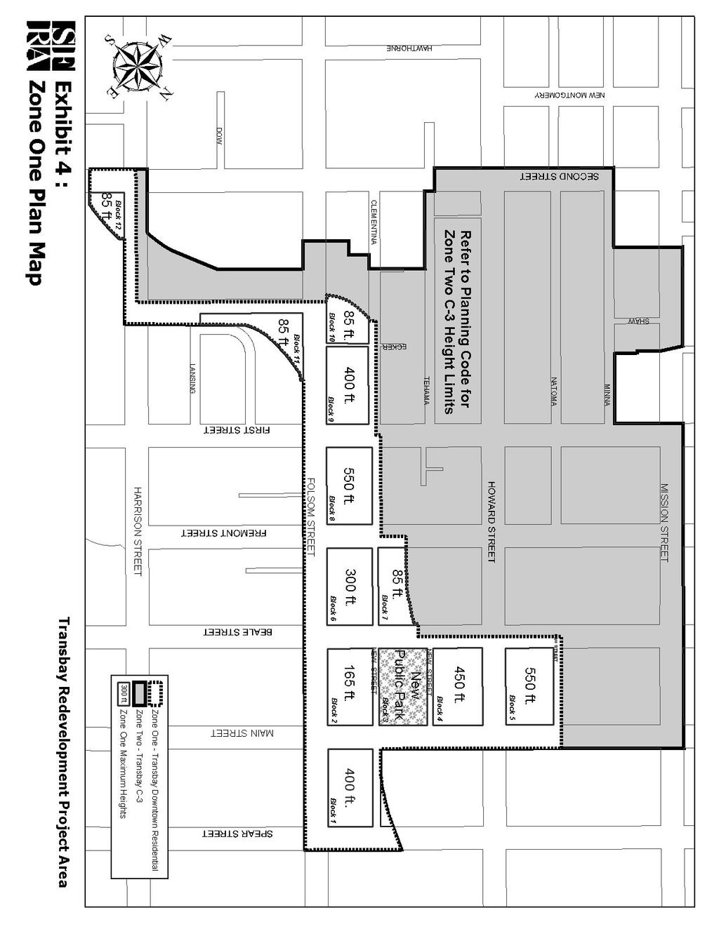
48 40
REDEVELOPMENT PLAN FOR THE COLISEUM AREA REDEVELOPMENT PROJECT
 REDEVELOPMENT PLAN FOR THE COLISEUM AREA REDEVELOPMENT PROJECT Adopted July 25, 1995 As Amended Up To March 17, 2009 Prepared by the REDEVELOPMENT AGENCY OF THE CITY OF OAKLAND Coliseum Area Redevelopment
May 2011 REDEVELOPMENT PLAN FOR THE CALIMESA REDEVELOPMENT PROJECT AREA NO. 2 CALIMESA REDEVELOPMENT AGENCY. Ordinance introduced on, 2011
 May 2011 REDEVELOPMENT PLAN FOR THE CALIMESA REDEVELOPMENT PROJECT AREA NO. 2 CALIMESA REDEVELOPMENT AGENCY Ordinance introduced on, 2011 Ordinance adopted on, 2011 Redevelopment Plan Prepared for the
AMENDED AND RESTATED REDEVELOPMENT PLAN FOR THE GREATER CHICO URBAN AREA REDEVELOPMENT PROJECT
 AMENDED AND RESTATED REDEVELOPMENT PLAN FOR THE GREATER CHICO URBAN AREA REDEVELOPMENT PROJECT Prepared by the CHICO REDEVELOPMENT AGENCY Approved And Adopted By Chico City Council Ordinance No. 2294,
I. INTRODUCTION 141\15\
 I. INTRODUCTION The Third Amended and Restated Redevelopment Plan for the Central San Rafael Project Area (the "Amended Plan") consists of twenty-nine (29) pages of text and four (4) exhibits. This Amended
LAND USE AND ZONING OVERVIEW
 OVERVIEW OF PLANNING POLICIES LAND USE AND ZONING OVERVIEW The Minneapolis Plan for Sustainable Growth and Other Adopted Plans Community Planning and Economic Development Development Services Division
Town of Yucca Valley GENERAL PLAN 1
 Town of Yucca Valley GENERAL PLAN 1 This page intentionally left blank. 3 HOUSING ELEMENT The Housing Element is intended to guide residential development and preservation consistent with the overall values
Hennepin County Department of. Housing, Community Works and Transit. Transit Oriented Development (TOD) Guidelines
 Guidelines") Hennepin County Department of Housing, Community Works and Transit 2007 Transit Oriented Development (TOD) Guidelines Hennepin County Transit Oriented Development (TOD) Bond Funds Hennepin County Housing,
Hennepin County Department of Housing, Community Works and Transit 2007 Transit Oriented Development (TOD) Guidelines Hennepin County Transit Oriented Development (TOD) Bond Funds Hennepin County Housing,
 Page 1 of 8 Highlands County, Florida, Code of Ordinances >> - CODE OF ORDINANCES >> Chapter 5.4 - HOUSING >> ARTICLE II. STATE HOUSING INITIATIVES PARTNERSHIP PROGRAM >> ARTICLE II. STATE HOUSING INITIATIVES
EXHIBIT A CITY OF MENLO PARK AMENDED AND RESTATED LAS PULGAS COMMUNITY DEVELOPMENT PROJECT AREA PLAN. Adopted by Ordinance No. 670 November 24, 1981
 EXHIBIT A CITY OF MENLO PARK AMENDED AND RESTATED LAS PULGAS COMMUNITY DEVELOPMENT PROJECT AREA PLAN Adopted by Ordinance No. 670 November 24, 1981 Amended and Restated by Ordinance No. 826 September 10,
HOUSING ELEMENT GOALS, OBJECTIVES, & POLICIES
 HOUSING ELEMENT GOALS, OBJECTIVES, & POLICIES GOAL H-1: ENSURE THE PROVISION OF SAFE, AFFORDABLE, AND ADEQUATE HOUSING FOR ALL CURRENT AND FUTURE RESIDENTS OF WALTON COUNTY. Objective H-1.1: Develop a
CHAPTER 23A: SURPLUS CITY PROPERTY ORDINANCE
 CHAPTER 23A: SURPLUS CITY PROPERTY ORDINANCE Sec. 23A.1. Sec. 23A.2. Sec. 23A.3. Sec. 23A.4. Sec. 23A.5. Sec. 23A.6. Sec. 23A.7. Sec. 23A.8. Sec. 23A.9. Sec. 23A.10. Sec. 23A.11. Sec. 23A.13. Sec. 23A.14.
H 7291 S T A T E O F R H O D E I S L A N D
 LC000 01 -- H 1 S T A T E O F R H O D E I S L A N D IN GENERAL ASSEMBLY JANUARY SESSION, A.D. 01 A N A C T RELATING TO TOWNS AND CITIES -- REDEVELOPMENT AGENCIES AND PROJECTS Introduced By: Representatives
Village of Port Jefferson Urban Renewal Plan
 Urban Renewal Plan Village of Port Jefferson Urban Renewal Plan Port Jefferson, New York PREPARED FOR Village of Port Jefferson Village Board 121 West Broadway Port Jefferson, NY 11777 631.473.4724 PREPARED
Goals, Objectives and Policies
 Goals, Objectives and Policies 1. GOAL SUPPORT THE PROVISION OF DECENT, SAFE AND SOUND HOUSING IN A VARIETY OF TYPES, SIZES, LOCATIONS AND COSTS TO MEET THE NEEDS OF CURRENT AND FUTURE RESIDENTS OF UNINCORPORATED
SECTION 7000 LAND DEVELOPMENT REQUIREMENTS
 SECTION 7000 LAND DEVELOPMENT REQUIREMENTS 7000 LAND DEVELOPMENT REQUIREMENTS... 1 7001 LEGISLATIVE AUTHORITY... 1 7001.1 LAND DEVELOPMENT... 1 7001.1.1 Title 40, Idaho Code... 1 7001.1.2 Idaho Code 40-1415
BILL H.3653: An Act Financing the Production and Preservation of Housing for Low and Moderate Income Residents
 BILL H.3653: An Act Financing the Production and Preservation of Housing for Low and Moderate Income Residents SECTION 2 Authorizes capital spending amounts and provides line item language describing permitted
Downtown Meridian Urban Renewal Area URBAN RENEWAL ELIGIBILITY REPORT. Prepared for The City of Meridian and The Meridian Development Corporation
 Downtown Meridian Urban Renewal Area URBAN RENEWAL ELIGIBILITY REPORT Prepared for The City of Meridian and The Meridian Development Corporation by McKibben + Cooper Architects June 19, 2002 Authorization
ARTICLE 15 - PLANNED UNIT DEVELOPMENT
 Section 15.1 - Intent. ARTICLE 15 - PLANNED UNIT DEVELOPMENT A PUD, or Planned Unit Development, is not a District per se, but rather a set of standards that may be applied to a development type. The Planned
Creative Approaches to Land Acquisition
 2007 Legislative Session Review CALIFORNIA TRANSIT ASSOCIATION JANUARY/FEBRUARY 2008 Creative Approaches to Land Acquisition Result From Creative Approaches to Land Acquisition It should not surprise anyone
SECTION 23 PLANNED RESIDENTIAL DEVELOPMENT FOR ELDERLY PERSONS
 SECTION 23 PLANNED RESIDENTIAL DEVELOPMENT FOR ELDERLY PERSONS 23.1 General: In order to provide for the special needs of elderly and handicapped persons who may require multifamily type living accommodations,
LITTLE MOUNTAIN ADJACENT AREA REZONING POLICY
 LITTLE MOUNTAIN ADJACENT AREA REZONING POLICY JANUARY 2013 CONTENTS 1.0 INTENT & PRINCIPLES...1 2.0 APPLICATION...2 3.0 HOUSING TYPES, HEIGHT & DENSITY POLICIES...3 3.1 LOW TO MID-RISE APARTMENT POLICIES...4
THE COMMUNITY REDEVELOPMENt AGENCY OF THE CITY OF LOS ANGELES, CALIFORNIA AMENDED REDEVELOPMENT PLAN FOR THE
 APPENDIXD CPC-2013-~/{,'f -CA THE COMMUNITY REDEVELOPMENt AGENCY OF THE CITY OF LOS ANGELES, CALIFORNIA AMENDED REDEVELOPMENT PLAN FOR THE NORTH HOllYWOOD REDEVELOPMENT PROJECT North Hollywood Site Office
CHAPTER Committee Substitute for Committee Substitute for House Bill No. 437
 CHAPTER 2013-83 Committee Substitute for Committee Substitute for House Bill No. 437 An act relating to community development; amending s. 159.603, F.S.; revising the definition of qualifying housing development
TOTTENHAM SECONDARY PLAN
 TOTTENHAM SECONDARY PLAN AMENDMENT NO. 11 TO THE OFFICIAL PLAN OF THE TOWN OF NEW TECUMSETH The following text and schedules to the Official Plan of the Town of New Tecumseth constitute Amendment No. 11
ARTICLE 2: General Provisions
 ARTICLE 2: General Provisions 2-10 Intent The basic intent of the Town of Orange s Zoning Ordinance is to implement the goals and objectives of the adopted Town of Orange Comprehensive Plan, hereafter
Glendale Housing Development Project Plan
 Glendale Housing Development Project Plan Draft for Public Review May 29, 2015 Table of Contents I. Introduction... 1 II. Description of Project... 1 A. Boundary of Housing Development Project... 1 B.
CITY PLANNING COMMISSION COMPREHENSIVE PLAN AND REVIEW CRITERIA
 Page 3 CITY PLANNING COMMISSION COMPREHENSIVE PLAN AND REVIEW CRITERIA COMPREHENSIVE PLAN: The City Planning Commission uses the Comprehensive Plan as a guide in all land use matters. The Plan is available
Scattered Sites Redevelopment Plan
 Scattered Sites Redevelopment Plan Township of Woodbridge Middlesex County, New Jersey Prepared by: Township of Woodbridge Department of Planning & Development January 2017 Amended September 2018 ENDORSED
Montreal Road District Secondary Plan [Amendment #127, October 9, 2013]
![Montreal Road District Secondary Plan [Amendment #127, October 9, 2013]](/thumbs/72/66783104.jpg "Montreal Road District Secondary Plan [Amendment #127, October 9, 2013]") [Amendment #127, October 9, 2013] 1.0 General The following policies are applicable to the Montreal Road District as set out in Schedule 1. 1.1 District Objectives The objective of this Plan is to guide
[Amendment #127, October 9, 2013] 1.0 General The following policies are applicable to the Montreal Road District as set out in Schedule 1. 1.1 District Objectives The objective of this Plan is to guide
PROPOSED METRO JOINT DEVELOPMENT PROGRAM: POLICIES AND PROCESS July 2015 ATTACHMENT B
 PROPOSED METRO JOINT DEVELOPMENT PROGRAM: POLICIES AND PROCESS ATTACHMENT B TABLE OF CONTENTS I. INTRODUCTION / PURPOSE............................ 3 II. OBJECTIVES / GOALS..................................
Grant Contract Specified Grants
 State of California The Natural Resources Agency DEPARTMENT OF PARKS AND RECREATION Grant Contract Specified Grants GRANTEE City and County of San Francisco, Recreation and Parks Department GRANT PERFORMANCE
KANSAS CITY, MISSOURI HOMESTEADING AUTHORITY POLICIES AND PROCEDURES
 DEFINITIONS KANSAS CITY, MISSOURI HOMESTEADING AUTHORITY POLICIES AND PROCEDURES Property costs: Property costs are those costs associated with the acquisition of a parcel of property. Project costs: Project
DIVISION 1 PURPOSE OF DISTRICTS
 ARTICLE 2 ZONING DISTRICTS AND MAP DIVISION 1 PURPOSE OF DISTRICTS Section 2.101 Zoning Districts. For the purpose of this Ordinance, the City of Richmond is hereby divided into districts as follows: DISTRICT
HOUSING ELEMENT I. GOALS, OBJECTIVES AND POLICIES
 HOUSING ELEMENT I. GOALS, OBJECTIVES AND POLICIES GOAL 1: IN ORDER TO ACHIEVE A BALANCED HOUSING SUPPLY (AND A BALANCED POPULATION AND ECONOMIC BASE), EVERY EFFORT SHOULD BE MADE TO PROVIDE A BROAD RANGE
Provide a diversity of housing types, responsive to household size, income and age needs.
 8 The City of San Mateo is a highly desirable place to live. Housing costs are comparably high. For these reasons, there is a strong and growing need for affordable housing. This chapter addresses the
COOPERATIVE AGREEMENT BETWEEN THE REDEVELOPMENT AGENCY OF THE CITY OF RIO VISTA AND THE CITY OF RIO VISTA
 COOPERATIVE AGREEMENT BETWEEN THE REDEVELOPMENT AGENCY OF THE CITY OF RIO VISTA AND THE CITY OF RIO VISTA This Cooperative Agreement (this Agreement ) is entered into effective as of March 17, 2011 ( Effective
PLANNED UNIT DEVELOPMENTS (Ordinance No.: 3036, 12/3/07; Repealed & Replaced by Ordinance No.: 4166, 10/15/12)
") 159.62 PLANNED UNIT DEVELOPMENTS (Ordinance No.: 3036, 12/3/07; Repealed & Replaced by Ordinance No.: 4166, 10/15/12) A. PURPOSE 1. General. The Planned Unit Development (PUD) approach provides the flexibility
159.62 PLANNED UNIT DEVELOPMENTS (Ordinance No.: 3036, 12/3/07; Repealed & Replaced by Ordinance No.: 4166, 10/15/12) A. PURPOSE 1. General. The Planned Unit Development (PUD) approach provides the flexibility
MISSION STATEMENT LCLB PURPOSE PRIORITIES & POLICIES. 1. Policies Governing the Acquisition of Properties
 MISSION STATEMENT The LAWRENCE COUNTY LAND BANK (LCLB) will strategically acquire distressed properties and return them to productive, tax-paying use. The LCLB will: reduce blight; stabilize neighborhoods
ARTICLE 1 Development Code Applicability
 CITY OF GRASS VALLEY MUNICIPAL CODE - TITLE 17 - DEVELOPMENT CODE ARTICLE 1 Development Code Applicability Chapter 17.10 - Purpose and Applicability of Development Code... 1-3 17.10.010 - Purposes of the
Appendix A: Guide to Zoning Categories Prince George's County, Maryland
 Appendix A: Guide to Zoning Categories Prince George's County, Maryland RESIDENTIAL ZONES 1 Updated November 2010 R-O-S: Reserved Open Space - Provides for permanent maintenance of certain areas of land
Bunker Hill Part II Urban Design. Specific Plan. Case No. CPC SP TABLE OF CONTENTS
 Bunker Hill Part II Urban Design Specific Plan Case No. CPC-2011-684-SP TABLE OF CONTENTS Section 1. Section 2. Section 3. Section 4. Section 5. Section 6. Section 7. Section 8. Section 9. Section 10.
GENERAL ASSEMBLY OF NORTH CAROLINA SESSION 2015 S 2 SENATE BILL 554 Education/Higher Education Committee Substitute Adopted 6/24/16
 GENERAL ASSEMBLY OF NORTH CAROLINA SESSION S SENATE BILL Education/Higher Education Committee Substitute Adopted // Short Title: School Building Leases. (Public) Sponsors: Referred to: March 0, 1 0 1 A
ORDINANCE NO. AN ORDINANCE OF THE CITY COUNCIL OF THE CITY OF DALY CITY REPEALING AND REPLACING CHAPTER RE: INCLUSIONARY HOUSING
 ORDINANCE NO. AN ORDINANCE OF THE CITY COUNCIL OF THE CITY OF DALY CITY REPEALING AND REPLACING CHAPTER 17.47 RE: INCLUSIONARY HOUSING The City Council of the City of Daly City, DOES ORDAIN as follows:
City of Oakland Programs, Policies and New Initiatives for Housing
 City of Oakland Programs, Policies and New Initiatives for Housing Land Use Policies General Plan Update In the late 1990s, the City revised its general plan land use and transportation element. This included
GENERAL PLAN UPDATE SPECIFIC AREAS OF THE CITY
 GENERAL PLAN UPDATE SPECIFIC AREAS OF THE CITY Background There are a total of 14 specific areas that are being reviewed as part of the update of the General Plan. Requests to review these areas came from
ORDINANCE NO
 Item 4 Attachment A ORDINANCE NO. 2017-346 AN ORDINANCE OF THE CITY COUNCIL OF THE CITY OF CALABASAS, CALIFORNIA AMENDING CHAPTER 17.22 OF THE CALABASAS MUNICIPAL CODE, AFFORDABLE HOUSING, TO BRING INTO
PLANNED DEVELOPMENT NO. 158, AS AMENDED PLAN OF DEVELOPMENT STATEMENTS
 PLANNED DEVELOPMENT NO. 158, AS AMENDED PLAN OF DEVELOPMENT STATEMENTS 1. The area delineated herein as Residential-Business Planned Development No. 158, as amended, consists of approximately 262,963 square
TRANSBAY JOINT POWERS AUTHORITY
 STAFF REPORT FOR CALENDAR ITEM NO.: 17 FOR THE MEETING OF: September 10, 2015 BRIEF DESCRIPTION: TRANSBAY JOINT POWERS AUTHORITY Authorizing the Executive Director to sign and execute the Block 5 Easement
RESOLUTION NO A RESOLUTION OF THE CITY COUNCIL OF THE CITY OF SANTA ANA TO ESTABLISH A HOTEL DEVELOPMENT
 ROI-I: 06/ 07/ 16 RESOLUTION NO. 2016- A RESOLUTION OF THE CITY COUNCIL OF THE CITY OF SANTA ANA TO ESTABLISH A HOTEL DEVELOPMENT INCENTIVE PROGRAM FOLLOWS: BE IT RESOLVED BY THE CITY COUNCIL OF THE CITY
San Francisco Business and Tax Regulations Code
 1 of 6 4/5/2018, 7:58 PM San Francisco Business and Tax Regulations Code Sec. 15A.1. Sec. 15A.2. Sec. 15A.3. Sec. 15A.4. Sec. 15A.5. Purpose. Augmentation and Modification of State Law Requirements Governing
THE CITY OF LAKE FOREST ORDINANCE NO. AN ORDINANCE AMENDING THE LAKE FOREST CITY CODE TO ESTABLISH A HOUSING TRUST FUND BOARD
 THE CITY OF LAKE FOREST ORDINANCE NO. AN ORDINANCE AMENDING THE LAKE FOREST CITY CODE TO ESTABLISH A HOUSING TRUST FUND BOARD WHEREAS, the State of Illinois has enacted the Affordable Housing and Appeal
HOUSING ELEMENT GOALS, OBJECTIVES, AND POLICIES
 HOUSING ELEMENT GOALS, OBJECTIVES, AND POLICIES GOAL 1: To promote the preservation and development of high-quality, balanced, and diverse housing options for persons of all income levels throughout the
GENESEE COUNTY LAND BANK AUTHORITY POLICIES
 GENESEE COUNTY LAND BANK AUTHORITY POLICIES As Amended by the Board of Directors on April 18, 2018 Contents 1. Policies Governing the Acquisition of Properties... 3 2. Priorities Concerning the Disposition
CENTRAL DISTRICT URBAN RENEWAL PLAN OAKLAND, CALIFORNIA. June 12, As amended up to June 20, 2006
 CENTRAL DISTRICT URBAN RENEWAL PLAN Adopted June 12, 1969 As Amended Up To June 20, 2006 CENTRAL DISTRICT URBAN RENEWAL PLAN OAKLAND, CALIFORNIA June 12, 1969 As amended up to June 20, 2006 An amended
LEGISLATIVE PURPOSES. 2. Provide sources of agricultural products within the state for the citizens of the state
 LEGISLATIVE PURPOSES 1. Assist in sustaining the farming community 2. Provide sources of agricultural products within the state for the citizens of the state 3. Control the urban expansion which is consuming
TRANSBAY JOINT POWERS AUTHORITY
 STAFF REPORT FOR CALENDAR ITEM NO.: 15 FOR THE MEETING OF: March 10, 2011 TRANSBAY JOINT POWERS AUTHORITY BRIEF DESCRIPTION: Approving a Temporary Easement Agreement (Temporary Easement) between the Transbay
ASSEMBLY, No. 266 STATE OF NEW JERSEY. 218th LEGISLATURE PRE-FILED FOR INTRODUCTION IN THE 2018 SESSION
 ASSEMBLY, No. STATE OF NEW JERSEY th LEGISLATURE PRE-FILED FOR INTRODUCTION IN THE 0 SESSION Sponsored by: Assemblyman SEAN T. KEAN District 0 (Monmouth and Ocean) Assemblyman EDWARD H. THOMSON District
PROPOSED AMENDMENTS TO THE DERBY ZONING REGULATIONS AUGUST 12, 2008
 ARTICLE II Definitions and word usage 195-7. Definitions and word usage. Modify the following: HOUSING FOR THE ELDERLY OLDER PERSONS Housing in accordance with and as defined in the United States Fair
PART 1 - Rules and Regulations Governing the Building Homes Rhode Island Program
 860-RICR-00-00-1 TITLE 860 Housing Resources Commission CHAPTER 00 N/A SUBCHAPTER 00 N/A PART 1 - Rules and Regulations Governing the Building Homes Rhode Island Program 1.1 Purpose A. The purpose of these
LIHPRHA, Pub. L. No , Title VI (1990), codified at 12 U.S.C et seq.
, codified at 12 U.S.C et seq.") LIHPRHA, Pub. L. No. 101-625, Title VI (1990), codified at 12 U.S.C. 4101 et seq. TITLE VI--PRESERVATION OF AFFORDABLE RENTAL HOUSING Subtitle A--Prepayment of Mortgages Insured Under National Housing
LIHPRHA, Pub. L. No. 101-625, Title VI (1990), codified at 12 U.S.C. 4101 et seq. TITLE VI--PRESERVATION OF AFFORDABLE RENTAL HOUSING Subtitle A--Prepayment of Mortgages Insured Under National Housing
Community Improvement Plan. Corporation of the City of Owen Sound
 Community Improvement Plan Corporation of the City of Owen Sound July 2010 TABLE OF CONTENTS 1.0 INTRODUCTION 1.1 Background... 1.2 Project Area... 1.3 Purpose of a Community Improvement Plan... 1.4 Current
City of Valdosta Land Development Regulations
 Chapter 206 Section 206-1 Base Zoning Districts Standards for Uses, Structures, and Property Development (B) (C) Principal Uses and Structures. Principal uses and structures permitted in each base zoning
OWNERS, BUSINESSES AND TENANTS PARTICIPATION AND RE-ENTRY RULES
 OWNERS, BUSINESSES AND TENANTS PARTICIPATION AND RE-ENTRY RULES Prepared For The CALIMESA REDEVELOPMENT PROJECT NO. 2 THE CALIMESA REDEVELOPMENT AGENCY July 2010 OWNERS, BUSINESSES AND TENANTS PARTICIPATION
ORDINANCE NO
 ORDINANCE NO. 2014-160 AN ORDINANCE OF THE CITY COUNCIL OF THE CITY OF MENIFEE, CALIFORNIA, REPEALING SECTION 10.35 OF RIVERSIDE COUNTY LAND USE ORDINANCE NO. 460.152 AS ADOPTED BY THE CITY OF MENIFEE
3.1. OBJECTIVES FOR RESIDENTIAL LAND USE DESIGNATIONS GENERAL OBJECTIVES FOR ALL RESIDENTIAL DESIGNATIONS
 3. RESIDENTIAL LAND USE DESIGNATIONS INTRODUCTION The Residential land use designations provide for housing and other land uses that are integral to, and supportive of, a residential environment. Housing
Understanding Texas TIRZ Statute Chapter 311 Texas Tax Code
 CDFA/TEDC TIRZ SEMINAR Understanding Texas TIRZ Statute Chapter 311 Texas Tax Code Clark Stockton Lord Constitutional Authority The legislature by general law may authorize an incorporated city or town
Be linked by an internal circulation system (i.e., walkways, streets, etc.) to other structures within the IPUD;
 to other structures within the IPUD;") 2. HALIFAX ACTIVITY CENTER A. DESCRIPTIONS OF FUTURE LAND USE DESIGNATIONS Each of the future land use designations specified by Phase I of the Halifax Activity Center Plan, and the relationship of these
2. HALIFAX ACTIVITY CENTER A. DESCRIPTIONS OF FUTURE LAND USE DESIGNATIONS Each of the future land use designations specified by Phase I of the Halifax Activity Center Plan, and the relationship of these
7. IMPLEMENTATION STRATEGIES
 7. IMPLEMENTATION STRATEGIES A. GENERAL APPROACH FOR IMPLEMENTATION Implementing the plan will engage many players, including the Municipality of Anchorage (MOA), the Government Hill Community Council,
Guidelines for Implementation of the Inclusionary Housing Ordinance of the City of San José, Chapter 5.08 of the San José Municipal Code.
 Guidelines for Implementation of the Inclusionary Housing Ordinance of the City of San José, Chapter 5.08 of the San José Municipal Code. Interim Version Approved June 30, 2016 Revised July 16, 2018 This
FIRST AMENDMENT TO THE AMENDED AND RESTATED DEVELOPMENT PLAN FOR THE OFFICE BUILDINGS / SPORTS PROJECT WITHIN PLANNED DEVELOPMENT AREA NO.
 FIRST AMENDMENT TO THE AMENDED AND RESTATED DEVELOPMENT PLAN FOR THE OFFICE BUILDINGS / SPORTS PROJECT WITHIN PLANNED DEVELOPMENT AREA NO. 87 BOSTON LANDING GUEST STREET, LIFE STREET AND ARTHUR STREET
Housing Assistance Incentives Program
 Housing Assistance Incentives Program Adopted on March 28, 2016 Resolution No. 84-16 Table of Content Overview. 2 Definitions.. 2 Housing Assistance Incentives 5 Housing Trust Fund.. 7 City Owned Properties
CONDITIONAL GRANT COMMITMENT AND SITE LEASE FOR REHABILITATION OF VERMONT HOUSE
 CITY OF
DRAFT FOR DISCUSSION PURPOSES ONLY. Port Credit Local Area Plan Built Form Guidelines and Standards DRAFT For Discussion Purposes
 Port Credit Local Area Plan Built Form Guidelines and Standards DRAFT For Discussion Purposes 1 Local Area Plan - Project Alignment Overview Directions Report, October 2008 (General Summary Of Selected
13 Sectional Map Amendment
 13 Sectional Map Amendment Introduction This chapter reviews land use and zoning policies and practices in Prince George s County and presents the proposed zoning in the sectional map amendment (SMA) to
CHAPTER l5 INDUSTRIAL & COMMERCIAL PROJECT REVENUE BONDS. 74-ll7 Industrial and Commercial Revenue Bonds. l
 CHAPTER l5 INDUSTRIAL & COMMERCIAL PROJECT REVENUE BONDS ORDINANCE 74-ll7 Industrial and Commercial Revenue Bonds. l0.29.74 83-l6 Amending definition of "Development Project" contained in Sec. l5-l02.
RECITALS. WHEREAS, the GMA requires counties to adopt county-wide planning policies in cooperation with cities within the County; and
 AN INTERLOCAL AGREEMENT FOR THE IMPLEMENTATION OF A DEMONSTRATION PROJECT TO TRANSFER DEVELOPMENT RIGHTS FROM RURAL UNINCORPORATED KING COUNTY TO THE DENNY TRIANGLE IN DOWNTOWN SEATTLE This Agreement is
Be it resolved by the Council of the City of Pittsburgh as follows:
 Ordinance supplementing the Pittsburgh Code, Title One, Administrative, Article IX Boards, Commissions, by adding Chapter 174 A, entitled, The Pittsburgh Land Bank. Be it resolved by the Council of the
Housing Issues Report Shoreline Towers Inc. Proposal 2313 & 2323 Lake Shore Boulevard West. Prepared by PMG Planning Consultants November 18, 2014
 Housing Issues Report Shoreline Towers Inc. Proposal 2313 & 2323 Lake Shore Boulevard West Prepared by PMG Planning Consultants November 18, 2014 PMG Planning Consultants Toronto, Canada M6A 1Y7 Tel. (416)
CPC CA 3 SUMMARY
 CPC-2009-3955-CA 2 CONTENTS Summary Staff Report Conclusion 3 4 7 Appendix A: Draft Ordinance A-1 Attachments: 1. Land Use Findings 2. Environmental Clearance 1-1 2-1 CPC-2009-3955-CA 3 SUMMARY Since its
4/8/2015 Item #10E Page 1
 MEETING DATE: April 8, 2015 PREPARED BY: Glenn Pruim DEPT. DIRECTOR: Glenn Pruim DEPARTMENT: Public Works CITY MANAGER: Lawrence A. Watt SUBJECT: A COOPERATION AGREEMENT BETWEEN NORTH COUNTY TRANSIT DISTRICT
ARTICLE 3: Zone Districts
 ARTICLE 3: Zone Districts... 3-1 17.3.1: General...3-1 17.3.1.1: Purpose and Intent... 3-1 17.3.2: Districts and Maps...3-1 17.3.2.1: Applicability... 3-1 17.3.2.2: Creation of Districts... 3-1 17.3.2.3:
Title 6 - Local Government Provisions Applicable to Special Purpose Districts and Other Political Subdivisions
 Title 6 - Local Government Provisions Applicable to Special Purpose Districts and Other Political Subdivisions CHAPTER 29. SOUTH CAROLINA LOCAL GOVERNMENT COMPREHENSIVE PLANNING ENABLING ACT OF 1994 1994
SECTION 1 INTRODUCTION TO THE PANAMA CITY BEACH COMPREHENSIVE GROWTH DEVELOPMENT PLAN
 1. PURPOSE SECTION 1 INTRODUCTION TO THE PANAMA CITY BEACH COMPREHENSIVE GROWTH DEVELOPMENT PLAN The purpose of the City of Panama City Beach's Comprehensive Growth Development Plan is to establish goals,
PENNSYLVANIA AFFORDABLE HOUSING ACT Act of Dec. 18, 1992, P.L. 1376, No. 172 AN ACT Providing for the establishment and administration of an
 PENNSYLVANIA AFFORDABLE HOUSING ACT Act of Dec. 18, 1992, P.L. 1376, No. 172 AN ACT Cl. 48 Providing for the establishment and administration of an affordable housing program; and imposing additional powers
REPLACEMENT HOUSING PLAN
 REPLACEMENT HOUSING PLAN FOR THE DESERT VIEW NEIGHBORHOOD PROJECT Prepared for CITY OF LANCASTER REDEVELOPMENT AGENCY 44933 FERN AVENUE LANCASTER, CALIFORNIA 93534 By Lancaster Redevelopment Agency 44933
A Form Shopping Center Lease
 A Form Shopping Center Lease Julian Rackow Julian Rackow is a partner with Blank Rome, LLP, in Philadelphia and is experienced in all facets of real estate and retail development and finance. He has particular
WINSTON URBAN RENEWAL PLAN
 WINSTON URBAN RENEWAL PLAN Winston Urban Renewal Agency November, 2006 WINSTON URBAN RENEWAL PLAN ACKNOWLEDGEMENTS The Winston City Council appointed a Citizen Advisory Committee to oversee the preparation
H-POLICY 1: Preserve and improve existing neighborhoods. Ensure that Prince William County achieves new neighborhoods with a high quality of life.
 HOUSING Intent The intent of the Housing Plan is to provide a framework for providing for the housing needs of all residents of Prince William County. These needs are expressed in terms of quality, affordability,
ARLINGTON COUNTY, VIRGINIA. County Board Agenda Item Meeting of September 19, 2015
 ARLINGTON COUNTY, VIRGINIA County Board Agenda Item Meeting of September 19, 2015 DATE: August 28, 2015 SUBJECT: Request to authorize advertisement of public hearings by the Planning Commission and the
ORDINANCE NUMBER 1296 Page 2
 ORDINANCE NO. 1296 AN ORDINANCE OF THE CITY COUNCIL OF THE CITY OF PERRIS, COUNTY OF RIVERSIDE, STATE OF CALIFORNIA, APPROVING ORDINANCE AMENDMENT 13-03-0010 TO ALLOW FOR EMERGENCY, TRANSITIONAL AND SUPPORTIVE
Staff Report. Victoria Walker, Director of Community and Economic Development
 7.a Staff Report Date: July 11, 2017 To: From: Reviewed by: Prepared by: Subject: City Council Valerie J. Barone, City Manager Victoria Walker, Director of Community and Economic Development John Montagh,
WELCOME! TO THE UNIVERSITY ENDOWMENT LANDS BLOCK F PUBLIC OPEN HOUSE
 WELCOME! TO THE UNIVERSITY ENDOWMENT LANDS BLOCK F PUBLIC OPEN HOUSE The UEL & Block F What is the UEL? Site Location The University Endowment Lands (UEL) is a separate jurisdiction from the City of Vancouver
Housing. Approved and Adopted by City Council November 13, City Council Resolution City Council Resolution
 5 Housing Approved and Adopted by City Council November 13, 2018 Chapter 5 Housing 5.1 City Council Resolution 2018-096 5.2 Fontana General Plan CHAPTER 5 Housing This chapter of the General Plan Update
WORK SESSION DOCUMENT
 WORK SESSION DOCUMENT Legislative Commission s Subcommittee to Study the Availability and Inventory of Affordable Housing (Assembly Concurrent Resolution No. 11, File No. 97, Statutes of Nevada 2005) June
City and County of San Francisco
 City and County of San Francisco Controller s Office FY 2009-10 Development Impact Fee Report January 24, 2011 City and County of San Francisco FY 2009-10 Development Impact Fee Report January 24, 2011
St. Mary s County Comprehensive Zoning Ordinance Article 1. GENERAL PROVISIONS
 0 0 0 0 ARTICLE. GENERAL PROVISIONS CHAPTER 0 TITLE, PURPOSE AND ORGANIZATION Sections: 0. Title. 0. Authority. 0. Purpose. 0. Organization of the Zoning Ordinance. 0. Official Zoning Map. 0. Applicability.
RENTAL, LEASE AND SALE OF REAL PROPERTY
 RENTAL, LEASE AND SALE OF REAL PROPERTY Policy No. 6882 October 3, 2018 Page 1 of 7 Because of changes in enrollment, student assignment policies and other characteristics of the district from time-to-time,
PLANNING COMMISSION STAFF REPORT
 PLANNING COMMISSION STAFF REPORT West Capitol Hill Zoning Map Amendment Petition No. PLNPCM2011-00665 Located approximately at 548 W 300 North Street, 543 W 400 North Street, and 375 N 500 West Street
Title 8 - ZONING Division AFFORDABLE HOUSING. Chapter RESIDENTIAL DENSITY BONUS
 Sections: 822-2.202 Title. 822-2.204 Purposes. 822-2.206 Definitions. 822-2.208 State law. 822-2.402 Inclusionary unit density bonus. 822-2.404 Affordable unit density bonus. 822-2.406 Land donation density
DISCUSSION DRAFT 1 INTRODUCTORY PROVISIONS
 1 INTRODUCTORY PROVISIONS 1.1 GENERAL...3 Title 3 Authority 3 Applicability 3 Purpose 3 Regulatory Scope 4 Compliance 4 Fines and Penalties 4 Conflicting Provisions 5 Meaning & Intent 5 Text & Graphics