Chapter 3 Land Use and Growth Management
|
|
|
- Gladys Hensley
- 6 years ago
- Views:
Transcription
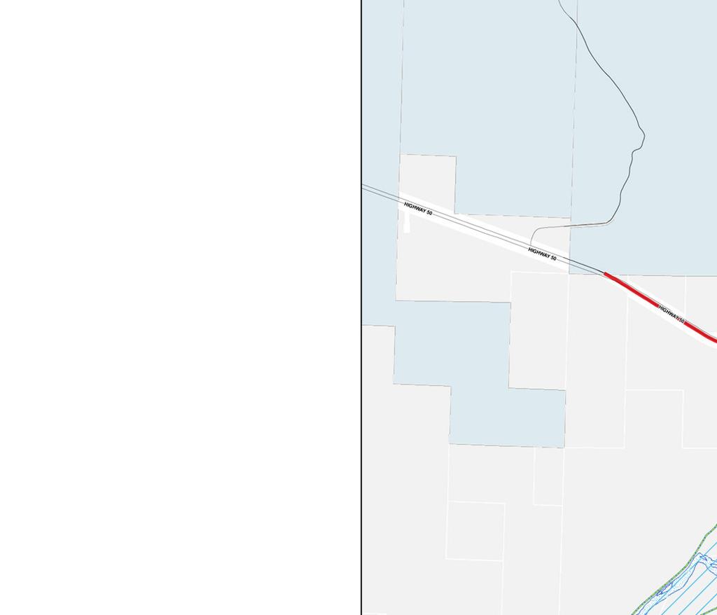
1 hapter 3 Land Use and Growth Management lanning Sub-Areas The geographic area included in a municipal comprehensive plan typically covers more than the current corporate limits. The following planning sub-areas are briefly described below: The surrounding lan Area ity of Delta current corporate limits Surrounding lan Area This omprehensive lan addresses the surrounding area, including that within the water and sewer service area and an approximate three mile radius. This is referred to as the plan area. In olorado, statutory authority for developing three mile plans is found in.r.s (c). The plan area includes gateways to the ity, which, along with surrounding irrigated farmland, Gunnison and Uncompahgre Rivers, the desert hills, the Grand Mesa and the Uncompahgre lateau, are an important part of Delta s community character. ity of Delta The current ity boundary forms the geographic center of the plan area. While it is appropriate to develop a plan that extends beyond the ity boundaries, as required by state law, the ity of Delta has legal authority to control growth and development only within its corporate limits, including additional land it may eventually annex. Development on land within the plan area outside present and future corporate limits of the ity of Delta is under the authority of the ounty. This omprehensive lan strongly recommends that the ity of Delta and Delta ounty develop an intergovernmental agreement whereby the county acknowledges and honors the land uses and densities specified in the plan area. Analysis of Existing Land Use The consultants conducted a parcel-based land use inventory of Delta and the surrounding three mile plan area during The field survey was correlated with the ounty Assessor s parcel maps and data, particularly for parcels where it was difficult to determine the type of land use from the field survey alone. The purpose of the inventory was to identify and quantify various types of land uses and densities to serve as a basis for projecting future growth and developing alternative growth management scenarios. Existing land use maps of the plan area (Map 3-1) and the core area (Map 3-2) were prepared which delineated the types of existing land uses, and tables were created summarizing the data. 3-1

2 3-2 Map 3-1

3 Map
4 Build-out Assumptions and alculations This section analyzes residential and commercial build-out potential of vacant land based on densities allowed by the ity of Delta s current land use code. A build-out analysis estimates the total population (or dwelling units or commercial square footage, etc.) of an area based on assumptions about allowable density. Residential build-out analysis, for example, identifies the supply of developable land, identifies development densities by location, calculates the number of new housing units, and then multiplies housing units by estimated number of people per unit to obtain the total potential population of the land. The build-out population of an area is the hypothetical capacity based on assumptions about allowable densities, which might or might not occur in the future. By contrast, a projection combines this supply of land and associated population with the anticipated regional demand for population for a particular time frame. Residential Build-Out otential Vacant parcels and underdeveloped agricultural parcels within the ity of Delta were identified based on field observations and the Delta ounty Assessor database. The acreage of each vacant parcel and agricultural parcel was obtained from the database and aggregated by residential zoning districts. Table 3-1 summarizes build-out potential for residential zoning districts, expressed as new housing units and additional population. Approximately 1,800 new housing units could be built on vacant parcels and underdeveloped agricultural parcels within the city s residential zoning districts, resulting in an additional population of about 4,428. The number of new housing units at build-out is a conservative estimate, given the large number of vacant or underdeveloped acres in the A-1 Zone. With the availability of city services, market pressures would likely cause much of this zone to be rezoned for higher densities. omparison of Residential Build-out otential with Alternative opulation rojections Figure 3-1 shows a graphic comparison of the build-out potential based on the existing city residential zones and the three alternative population projections for 2030: low growth (1.0% annual average), moderate growth (3.6% annual average) and high growth (5.0% annual average). Figure 3-1 shows that residential build-out potential under current zoning densities would accommodate a low growth rate. urrent (2006) population 7,782 plus additional population of 4,428 at build-out under existing zoning densities results in a build-out population of 12,210. The low growth projection (1% annual growth rate) results in a 2030 low growth projection of 9,822. Under this scenario the low growth additional population could be entirely accommodated under existing zoning within the Delta city limits without additional annexations. 3-4
5 Table 3-1 RESIDENTIAL BUILD-OUT OTENTIAL BY RESIDENTIAL ZONING DISTRIT (Based on urrent Zoning within ity of Delta) Residential Zones Estimated Occupied Units 1 # Vacant Acres Allowable Density (# units/ gross acre) # otential New Units Estimated otential Additional opulation (New units x 2.47 persons per house hold) A-1 2, R-R R R-1A R-2 1, ,265 R R MHR MR OR Totals 5, ,428 otential build out population (current zoning): 4, ,782=12,210 1 Based on olorado State Demographer s 2005 estimate of 2.47 persons per occupied housing unit. 3-5
6 Figure 3-1 omparison of current population, build-out population and alternative population projections, ity of Delta 30,000 urrent opulation 25,000 Build-out opulation 20,000 15,000 10,000 5, Low opulation Growth (1.0%) 2030 Moderate opulation Growth (3.6%) 2030 High opulation Growth (5.0%) opulation 7,782 Build-out opulation 12, Low opulation Growth (1.0%) 9, Moderate opulation Growth (3.6%) 18, High opulation Growth (5.0%) 25,
7 ommercial and Industrial Build-Out otential This section analyzes current and future demand for commercial/industrial space and the supply of land available to accommodate future demand. Demand for ommercial/industrial Space - Square footage of commercial and industrial uses per person is an indicator of demand for commercial/industrial space in a community as well as an indicator of the relative economic independence of an area. During the past decade, the omprehensive lan consultant analyzed commercial/industrial space in other communities. Fruita, which is in the economic shadow of Grand Junction, had 90 square feet of commercial/industrial uses per person within its three mile plan area and 71 square feet per person within the city limits. By comparison, communities that serve as the central market area for a larger region have more commercial/industrial square footage per person. For example, 170 sq.ft. for agosa Springs and 215 sq. ft. for Gunnison. As seen in Table 3-2 and the narrative below, Delta, like Gunnison and agosa Springs, functions as a regional center of economic activity, serving much of Delta ounty, including the small communities along State Highway 65 and Highway 92. As a result, Delta has a relatively large amount of commercial/industrial square footage per city resident. Based on the land use inventory and Delta ounty Assessor data, square footage for various categories of commercial and industrial uses within the plan area was aggregated. Table 3-2 indicates the aggregated square footage for various types of commercial and industrial buildings. TABLE 3-2 OMMERIAL AND INDUSTRIAL ARELS Type of Use # of arcels with Structures Aggregate Building Size (Sq. Ft.) ommercial ,040 Intensive commercial ,782 Multiple commercial ,714 Sub-total commercial 270 1,467,536 Industrial 99 1,204,933 TOTALS 639 2,672,469 1 ommercial uses that are typically dependent on a high volume of traffic, such as fast food establishments, service stations and supermarkets. 2 More than one commercial establishment on a parcel, often two or more uses in one building. 3-7
8 With an estimated 2005 population of 30,255 in Delta ounty, the amount of commercial/ industrial space is approximately 88 square feet per person (2,672,469 square feet divided by 30,255 people). The ounty total population rather than the ity of Delta population is used in this calculation because the commercial/industrial land uses serve much of the county population. The number of commercial/industrial parcels and the number of aggregate square footage reflect totals for only the plan area. There are other pockets of commercial and industrial uses along US 50 toward Montrose and in the smaller communities along State Highway 92 and Highway 65. However, it should be noted that most commercial/industrial uses in the plan area are located within the ity of Delta. Using only the population of the ity of Delta, where most commercial/industrial land uses are located, yields approximately 319 square feet per person (2,479,380 square feet within the city limits divided by the 2006 population of 7,782). This high number of commercial/industrial square footage per city resident indicates the importance of Delta as a regional shopping and manufacturing center for the area. Assuming for planning purposes that the demand for future commercial/industrial square footage within the ity of Delta can be estimated based on 319 square feet per person, the amount of commercial/industrial space needed by 2030 in the ity for each alternative growth scenario (see rogress Report #2) is as follows: Low growth (1.0% annual average) 9,822 people x 319 sq. ft. /person = 3,133,218 sq. ft. Moderate growth (3.6% annual average) 18,544 people x 319 sq. ft. /person = 5,915,536 sq. ft. High growth (5.0% annual average) 25,937 people x 319 sq. ft. /person = 8,273,903 sq. ft. Supply of ommercial/industrial Land -- Based on existing land use patterns, it cannot be assumed that all vacant commercial land will be fully occupied by buildings. Except for some downtown parcels, most commercial and industrial lots allocate space for parking, landscaping or outdoor storage. The portion of a lot occupied by buildings relative to total lot size is typically expressed as a floor area to lot size ratio, commonly referred to as a floor area ratio (FAR). This ratio is an indicator of the relative efficiency of use of the land. For example, a FAR of 0.1 indicates that only one-tenth of a parcel is occupied by a building. A FAR of 0.5 indicates much higher land use efficiency half of a parcel occupied by a building. In urban areas, including downtown Delta, some parcels have a FAR of more than 1.0, usually indicating buildings with two or more floors. The FARs for the various categories of commercial/industrial land uses in Delta are presented in Table 3-3, which indicates the ratio of aggregate building square footage to aggregate parcel area per category. The aggregate FAR for all commercial/industrial uses within the plan area is 0.026, which means that average lot coverage by buildings is less than 3 % of lot size. The low FAR is caused by several very large parcels comprising industrial land uses. The FAR for industrial uses only is merely 0.014, meaning that an average of only about 1.4 % of 3-8
9 industrial parcels is covered by structures. By contrast the FAR for more conventional parcels is 0.098, meaning that about 10 percent of the area of these parcels is occupied by structures. TABLE 3-3 OMMERIAL/INDUSTRIAL FLOOR AREA RATIOS BY ATEGORY Type of Use Aggregate Building Square Feet Aggregate arcel Area (sq. ft.) Floor Area Ratio ommercial 930,040 9,736, Intensive commercial 467,782 4,799, Multiple commercial 69, , Sub-total commercial 1,467,536 14,986, Industrial 1,204,933 86,381, TOTALS 2,672, ,367, While Table 3-3 displays data for various categories of commercial and industrial land uses, as indicated by the land use survey, Table 3-4 displays data by zoning district. Table 3-4 shows that there are nearly 200 vacant acres within the existing commercial and industrial zoning districts. Applying existing FARs for commercial and industrial uses, these vacant parcels could accommodate about 581,000 additional square feet of commercial/industrial uses. TABLE 3-4 SULY OF OMMERIAL AND INDUSTRIAL LAND BY ZONE Zone # Vacant Acres Floor Area Ratio Aggregate Additional Building Square Feet B ,123 B ,184 B ,629 B ,790 I ,309 I ,313 IR ,366 TOTALS ,714 onclusions Table 3-5 compares existing commercial/industrial square footage, additional supply of such land, as shown in Table 3-4, and the demand for commercial/ industrial land for the three alternative growth projections. Based on the above assumptions and calculations, it appears that there is a sufficient supply of land now zoned commercial/industrial land within the ity of Delta to accommodate 2030 demand for commercial/industrial square footage for the low growth scenario. 3-9
10 However, the potential supply falls short of the demand for commercial/industrial square feet for the moderate growth and high growth scenarios. It is likely that the shortfall could be accommodated within the plan area outside the present ity limits. Or the ity could rezone some of the A-1 parcels within the ity limits as commercial or industrial zones. TABLE 3-5 OMARISON OF OMMERIAL AND INDUSTRIAL LAND SULY AND DEMAND Supply (Square Feet) Demand (Square Feet) Existing Additional Total at Buildout High Growth Low Medium Supply Growth Growth 2,672, ,714 3,253,183 3,182,328 6,008,256 8,403,588 ublic Opinion about Growth The public opinion survey included several questions about growth. When asked about the ity of Delta s growth rate, 43% believed the ity was growing at the right pace and 31% felt it was growing too fast; 45% thought the best population level for Delta in the next 15 years would be from 10,000-12,500. See also comments on Steering ommittee recommendation in the Appendix. Alternative Growth Scenarios Alternative growth scenarios represent differing visions about how a community should grow. These visions were expressed by the public in several venues: interviews with community leaders; a written survey completed by approximately 1,026 households (29% of those sent out), and public workshops. Three scenarios were developed to explore the probable development patterns resulting from those differing visions. The three scenarios are: 1. Scenario 1 Low Growth (1%): This scenario is based on densities allowed by the current Land Use ode. 2. Scenario 2 Moderate Growth (3.6%): Most new growth for this scenario is concentrated within the current ity limits. 3. Scenario 3 High Growth (5%): This scenario includes new growth within the current ity limits and adds new development to more sparsely settled areas surrounding the ity. The three alternative growth scenarios were presented to the Steering ommittee for review before presentation to the public at the second public workshop. The Steering ommittee was divided in their preference between the medium and high growth scenarios. The three growth scenarios were then presented at public workshop #2. The resulting opinion from this workshop mirrored that of the Steering ommittee. Both groups defined 3-10
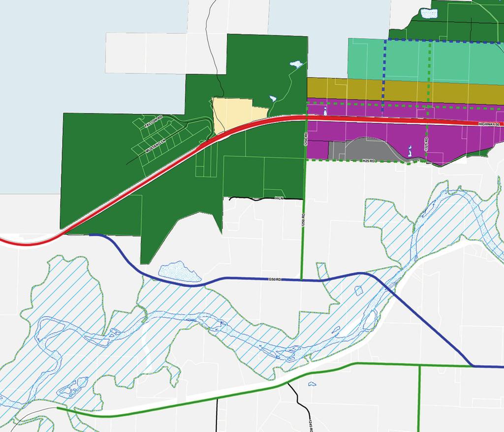
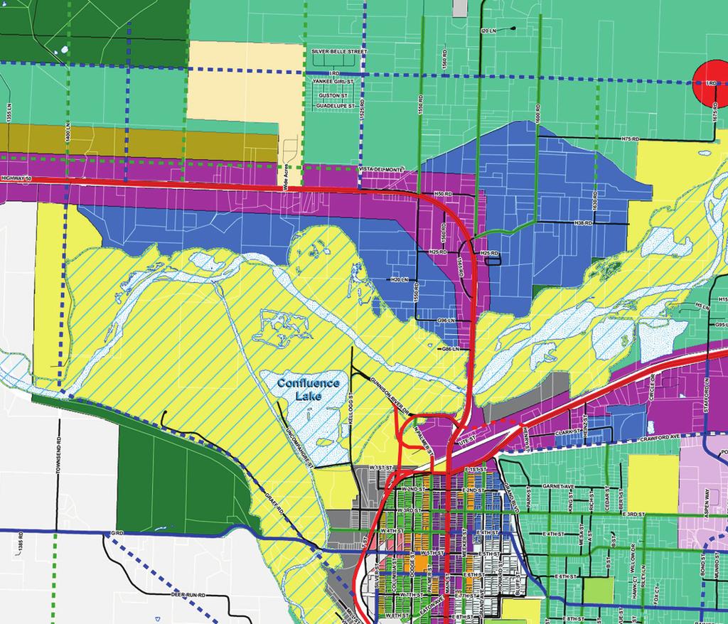
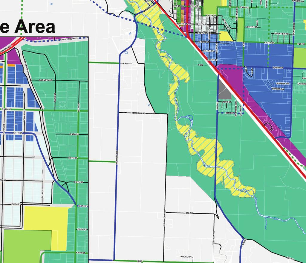
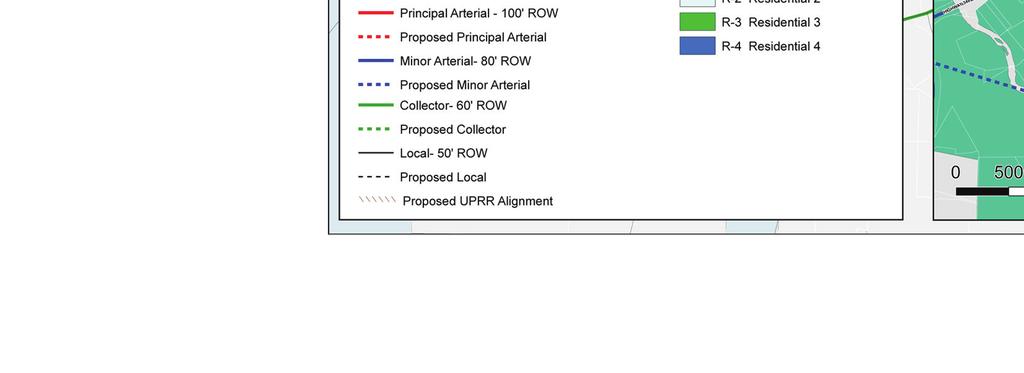
11 future growth areas using a dot exercise in which they placed dots in potential new growth areas in, and around Delta. The growth areas selected by the groups were similar for both the public workshop and the steering committee. referred Growth Scenario The preferred growth scenario is derived from a combination of the moderate and high growth scenarios. This preferred scenario adopts a strong downtown core and other smaller commercial nodes to serve both residents and visitors. Most new growth is concentrated within the present ity limits or in the area east, west and south of the ity. This scenario attempts to accommodate future residential and commercial growth and encourages an economically healthy, vibrant downtown. The goal of the preferred scenario is to continue to make Delta look, feel, and act like a regional commercial center. A city feels like a unique place when it enhances the walkability of the entire community and creates a pleasant ambiance, such as treescapes, flowers, and benches along sidewalks, art and attractive signs throughout the community, especially in the downtown. And a community acts like a unique place when it promotes the existing friendly spirit of its citizens, especially toward visitors and new businesses, preserves and expands community events and celebrations and promotes local produce and products, such as farmer s markets. The future land use maps for the preferred scenario (see Future Land Use Map lan Area and Future Land Use Map ore Area) have the following land use classifications and features. The existing ity of Delta zone(s) that correspond to these districts is listed in parenthesis. Low Density Residential-Rural (A-1, R-R) This is the outlying residential and agricultural area surrounding the center of the ity. Medium Density Residential: (R-1, R-1A, R-2) This density corresponds to the ity s single family homes/duplexes/condominiums at a density that can be supported by ity utilities and which encourages walkable neighborhoods. High Density Residential: (R-2, R-3, R-4 ) The future land use map specifies additional high density areas in the downtown, east along State Highway 92 and west along U.S. 50 where apartments and condominiums will support the village concept of a walkable community. Mobile Home Residential (MHR): Existing mobile home parks are indicated on the future land use map. It is quite possible that, within the 20 year time frame covered by the comprehensive plan, owners of some of the mobile home parks may seek to redevelop them. Downtown ore Zoning (B-1, B-2, B-3, B-4, I-1, I-2, IR, MHR, MR, OR, R-1, R- 1A, R-2, R-3, R-4): The existing Downtown zoning is retained as shown on the Future Land Use Map. Neighborhood ommercial enters (B-2): Neighborhood commercial centers are located at key intersections of medium density residential areas. These areas can provide walkable, small scale neighborhood retail and commercial uses such as coffee 3-11
12 shops, hair salons, boutiques, and professional offices with designs that are compatible with the neighborhood scale. They may also include neighborhood school sites. Highway ommercial Design Districts (B-2, OR, R-3, R-4): These areas are located along U.S. 50 and I Road west of town and along State Highway 92 east of town and south of town on Highway 50. These areas can develop as attractive commercial areas with frontage landscaping and low signage similar to the greenhouse restaurant on U.S. 50. As these areas develop, frontage roads and consolidated driveways should be required to minimize multiple curb cuts. This district would also allow multi family housing which could be located to the rear of the highway and commercial uses on deep lots as is now allowed in the Delta B-3 zone. Outdoor storage would be allowed but required to be located to the rear of the parcel and screened from view. otentially polluting commercial businesses would not be allowed in this zone or would have to meet performance standards. lanned Industrial (I-1, I-2, I-R, B-3) : Industrial uses are shown on the future land use map along the north side of Highway 92 and adjacent to the railroad at the grain elevator area. Such uses include storage units, some of which are located in the downtown Mixed Use area. These areas would be required to be well planned with combined entry ways, attractive signage, screening and landscaping. arks-open Space: The existing and future parks, trails and open space are shown on the maps in the arks, Recreation and Trails (hapter 8). The entire Gunnison and Uncompagre River, 100 year flood plain, is shown as open space, recognizing the need to protect these areas from the severe flooding that Delta has experienced in the past. Future Arterial and ollector Roads: These roads including the proposed truck by pass are indicated here and in the Transportation hapter. 3-12
13 Desired Future ondition, olicies and Action Items Desired Future ondition Growth and development are managed to preserve and enhance the quality of life that makes Delta an attractive place to live and visit. The downtown core is revitalized as a walkable village center with a well-designed mix of residential and commercial uses that serve both residents and visitors. Edges of the community are clearly defined by surrounding agricultural land and future growth is concentrated within the present ity boundaries. olicies and Action Items olicy 1--Growth will be controlled preserving green spaces at critical locations. olicy 2--Future growth should be planned under the medium to high growth scenarios. olicy 3--New development should pay its own way. olicy 4--Downtown should become a mixed use area with single family and multi family residences, offices and retail establishments that serve the needs of residents and tourists. An action item to implement this policy would be: Amend the land use code to include a new mixed use district in the downtown area with appropriate land uses and design guidelines. olicy 5--Improve the appearance of downtown olicy 6--The ity of Delta should encourage commercial growth along US 50 to the north and south. olicy 7-- The ity of Delta should encourage commercial growth along the highway corridor to the east olicy 8-- The ity of Delta should encourage growth along the railroad and recycle the old industrial buildings and agribusiness buildings into small scale industrial and commercial businesses. 3-13
14 Delta omprehensive lan 1997 ity of Delta 1997 omprehensive lan Land Use Goals As an overall goal, the ity of Delta will encourage location and types of land uses which are compatible to protect the health, safety and general welfare of the citizens Status (=completed, I=incomplete, =in progress) I Section One: eripheral Growth romote development around the outskirts of Delta I in a manner which will efficiently utilize public services and facilities Guidelines Work with the ounty to establish an area of cooperation in which both entities work together on issues of new growth, such as the provision of services and impacts oordinate development in the peripheral areas of the ity with the extension of utilities, new schools, parks, and other public facilities Encourage the ounty to promote land use controls I which assure the health, safety, and welfare of ounty residents such as land use planning and building codes Encourage some areas to remain as no growth areas where open space can remain as agricultural land, public or private, to preserve s connection with its agricultural heritage Actions 1. Extend the ity s utility service areas to serve the citizens of Delta. 2. omplete a municipal utility service plan 3. roactively pursue outside funding for the extension of utilities to outlying areas. urrent users should not support new development financially Section Two: Existing Land Use Goals Reassess the ity s existing land use pattern to determine the impact of current growth trends as well as the application of the ity s vision for the future Guidelines romote better integration of all types of uses within the ity and new developments 3-14
15 ity of Delta 1997 omprehensive lan Look at cultural, natural, and scenic attributes which define the ity s character when implementing land use decisions Actions 1. Inventory existing land uses to provide a data base for future decision making 2. Review changes in major land uses and emerging land use trends which have occurred since the last rezoning study done in Review current zoning districts and how they relate to one another 4. Adopt recommendations for change as a result of review process through the ity s lanning ommission 5. To the extent possible, buffer noxious uses from residential areas. Develop a buffer around the industrial zones of the ity Section Three: Guiding Growth Goals Guide the location of new growth so as to assure the maximum utilization of land, public facilities and services Guidelines Encourage development in areas immediately adjacent to existing development Encourage coordination between special districts and the ity on development which will have a significant impact on the pattern of growth of the ity Use open space as a tool to shape and direct density to buffer conflicting land uses, and to preserve the community s rural character Encourage growth based on the ability to serve by municipal utilities in a cost effective manner. Discourage service to new developments which would need to be subsidized by existing users Develop a cooperative working relationship with ounty and its lanning ommission oordinate development with the School District to address impacts Encourage infill development to avoid strip commercial development along major arterial roads onsider environmental impacts of new development such as air quality Status (=completed, I=incomplete, =in progress) I 3-15
16 Actions Update the ity s land use plan to indicate preferred locations for various uses within the ity and surrounding areas omplete a three mile plan for the ity Establish a communications network between the ity, State, and Federal land agencies to address land use policies affecting its citizens Section Four: Regulatory Environment Goals romote the consistent and equitable application of land use and development regulation Guidelines Increase public information regarding land use and development guidelines and processes Ensure that ity and ounty land use regulations are compatible Actions Modify the wording of existing regulations to provide increased clarity and consistency Standardize the variance procedure for zoning changes and exceptions to building codes I II 3-16


17
8Land Use. The Land Use Plan consists of the following elements:
 8Land Use 1. Introduction The Land Use Plan consists of the following elements: 1. Introduction 2. Existing Conditions 3. Opportunities for Redevelopment 4. Land Use Projections 5. Future Land Use Policies
TASK 2 INITIAL REVIEW AND ANALYSIS U.S. 301/GALL BOULEVARD CORRIDOR FORM-BASED CODE
 TASK 2 INITIAL REVIEW AND ANALYSIS U.S. 301/GALL BOULEVARD CORRIDOR FORM-BASED CODE INTRODUCTION Using the framework established by the U.S. 301/Gall Boulevard Corridor Regulating Plan (Regulating Plan),
GOALS, OBJECTIVES, AND STRATEGIES
 GOALS, OBJECTIVES, AND STRATEGIES What follows is a series of goals, recommendations and actions that reflect the themes outlined in the Mineral Springs Vision Plan (incorporated into this document as
Land Use. Land Use Categories. Chart 5.1. Nepeuskun Existing Land Use Inventory. Overview
 Land Use State Comprehensive Planning Requirements for this Chapter A compilation of objectives, policies, goals, maps and programs to guide the future development and redevelopment of public and private
TOWN OF BROOKLINE, NEW HAMPSHIRE
 TOWN OF BROOKLINE, NEW HAMPSHIRE BUILDOUT ANALYSIS DECEMBER, 2003 Prepared by the Nashua Regional Planning Commission TABLE OF CONTENTS Introduction... 1 I. Methodology... 1 A. PARCEL REVIEW... 1 B. DEVELOPMENT
4.2 LAND USE INTRODUCTION
 4.2 LAND USE INTRODUCTION This section of the EIR addresses potential impacts from the Fresno County General Plan Update on land use in two general areas: land use compatibility and plan consistency. Under
Appendix A: Guide to Zoning Categories Prince George's County, Maryland
 Appendix A: Guide to Zoning Categories Prince George's County, Maryland RESIDENTIAL ZONES 1 Updated November 2010 R-O-S: Reserved Open Space - Provides for permanent maintenance of certain areas of land
City of Coral Gables Planning and Zoning Staff Report
 City of Coral Gables Planning and Zoning Staff Report Applicant: Application: Public Hearing: Date & Time: Location: City of Coral Gables Zoning Code Text Amendment Giralda Plaza Overlay District Planning
TOWN OF PELHAM, NEW HAMPSHIRE
 TOWN OF PELHAM, NEW HAMPSHIRE BUILDOUT ANALYSIS Prepared for the PELHAM CONSERVATION COMMISSION with the assistance of the NASHUA REGIONAL PLANNING COMMISSION TABLE OF CONTENTS I. INTRODUCTION...1 II.
To achieve growth, property development, redevelopment and an improved tax base in the cities and boroughs in the Lehigh Valley.
 Most growth in property valuation is in townships. Between 1991 and 2004, the assessed valuation of the townships in the Lehigh Valley increased by more than $2.8 billion, an increase of 41%. At the same
3. FISCAL IMPACT ANALYSIS FISCAL IMPACT ANALYSIS 29
 3. FISCAL IMPACT ANALYSIS FISCAL IMPACT ANALYSIS 29 The purpose of fiscal impact analysis is to estimate the impact of a development or a land use change on the budgets of governmental units serving the
Town of Yucca Valley GENERAL PLAN 1
 Town of Yucca Valley GENERAL PLAN 1 This page intentionally left blank. 3 HOUSING ELEMENT The Housing Element is intended to guide residential development and preservation consistent with the overall values
FUTURE LAND USE. City of St. Augustine Comprehensive Plan EAR-Based Amendments
 FUTURE LAND USE City of St. Augustine Comprehensive Plan EAR-Based Amendments Future Land Use Element FLU Goal To create an environment within the City and adjacent areas in which its residents have the
Eastern Corridor Planning Area Workshop No April 2016
 Eastern Corridor Planning Area Workshop No. 3 28 April 2016 Agenda 1. Visual Aids 2. Guiding Principles 3. Preferred Alternative Concept Plan 4. Fiscal Impact Analysis 5. Findings 6. Recommendations 7.
Housing Characteristics
 CHAPTER 7 HOUSING The housing component of the comprehensive plan is intended to provide an analysis of housing conditions and need. This component contains a discussion of McCall s 1990 housing inventory
Analysis of Infill Development Potential Under the Green Line TOD Ordinance
 Analysis of Infill Development Potential Under the Green Line TOD Ordinance Prepared for the Los Angeles County Second Supervisorial District Office and the Department of Regional Planning Solimar Research
PC Staff Report 11/18/2013 Z Item No. 1-1
 Z-13-00401 Item No. 1-1 PLANNING COMMISSION REPORT Regular Agenda - Public Hearing Item PC Staff Report 11/18/2013 ITEM NO. 1: Z-13-00401 IG (General Industrial) District TO CS (Strip Commercial) District;
Bylaw No , being "Official Community Plan Bylaw, 2016" Schedule "A" DRAFT
 Bylaw No. 2600-2016, being "Official Community Plan Bylaw, 2016" Schedule "A" Urban Structure + Growth Plan Urban Structure Land use and growth management are among the most powerful policy tools at the
PLANNING & ZONING DEPARTMENT Town Hall Annex, 66 Prospect St., Ridgefield, CT Fax
 PLANNING & ZONING DEPARTMENT Town Hall Annex, 66 Prospect St., Ridgefield, CT 06877 203-431-2766 Fax 203-431-2737 ADOPTED AMENDMENT TO THE ZONING REGULATIONS NEW Section 5.6 Neighborhood Business Zone
Town of Prescott Valley 2013 Land Use Assumptions
 Town of Prescott Valley 2013 Land Use Assumptions Raftelis Financial Consultants, Inc. November 22, 2013 Table of Contents Purpose of this Report... 1 The Town of Prescott Valley... 2 Summary of Land Use
2014 Plan of Conservation and Development
 The Town of Hebron Section 1 2014 Plan of Conservation and Development Community Profile Introduction (Final: 8/29/13) The Community Profile section of the Plan of Conservation and Development is intended
A. Land Use Relationships
 Chapter 9 Land Use Plan A. Land Use Relationships Development patterns in Colleyville have evolved from basic agricultural and residential land uses, predominate during the early stages of Colleyville
Place Type Descriptions Vision 2037 Comprehensive Plan
 Place Type Descriptions Vision 2037 Comprehensive Plan The Vision 2037 Comprehensive Plan establishes a range of place types for Oxford, ranging from low intensity (limited development) Rural and Natural
P o p u l a t i o n, L a n d U s e, a n d Z o n i n g
 P o p u l a t i o n, L a n d U s e, a n d Z o n i n g The Town of Upper Marlboro is located only 15 miles southeast of the District of Columbia, in the central portion of Prince George s County in the
13 Sectional Map Amendment
 13 Sectional Map Amendment Introduction This chapter reviews land use and zoning policies and practices in Prince George s County and presents the proposed zoning in the sectional map amendment (SMA) to
Future Land Use Categories & Nodes December 23, Future Land Use Categories
 Future Land Use Categories & Nodes December 23, 2015 A note regarding nodes: Descriptions for nodes are located in the general recommendations handout. Node locations are set in part by the Auburn Interactive
Burlington Unincorporated Community Plan
 Burlington Unincorporated Community Plan June 30, 2010 Meeting Page 1 of 24 Table of Contents (Page numbers to be inserted) I. Background a. Location and Community Description b. Planning of Unincorporated
CHAPTER 2 VACANT AND REDEVELOPABLE LAND INVENTORY
 CHAPTER 2 VACANT AND REDEVELOPABLE LAND INVENTORY CHAPTER 2: VACANT AND REDEVELOPABLE LAND INVENTORY INTRODUCTION One of the initial tasks of the Regional Land Use Study was to evaluate whether there is
Rapid City Planning Commission Rezoning Project Report
 Rapid City Planning Commission Rezoning Project Report April 21, 2016 Item #9 Applicant Request(s) Case # 16RZ011; a request to rezone property from Central Business District to General Commercial District
L. LAND USE. Page L-1
 L. LAND USE 1. Purpose This section discusses current and likely future land use patterns in Orland. An understanding of land use trends is very important in determining Orland's ability to absorb future
HOUSING ELEMENT GOALS, OBJECTIVES, AND POLICIES
 HOUSING ELEMENT GOALS, OBJECTIVES, AND POLICIES GOAL 1: To promote the preservation and development of high-quality, balanced, and diverse housing options for persons of all income levels throughout the
PLANNING ANALYSIS ZONING CASE 18-TOD-Z-026 NAK S CROSSING PUD AMENDMENT. GC-3-A (General Commercial) GC-3-A (General Commercial)
 GC-3-A (General Commercial)") PLANNING ANALYSIS ZONING CASE 18-TOD-Z-026 NAK S CROSSING PUD AMENDMENT GENERAL INFORMATION Applicant/Owner: Current Zoning: Bruce Nakfoor PUD/TOD (Planned Unit Development/Transit Oriented Development
PLANNING ANALYSIS ZONING CASE 18-TOD-Z-026 NAK S CROSSING PUD AMENDMENT GENERAL INFORMATION Applicant/Owner: Current Zoning: Bruce Nakfoor PUD/TOD (Planned Unit Development/Transit Oriented Development
CITY OF FARMERSVILLE CITIZEN ADVISORY COMMITTEE AGENDA November 17, :30 P.M. 1, COUNCIL CHAMBERS, CITY HALL
 I. PRELIMINARY MATTERS CITY OF FARMERSVILLE CITIZEN ADVISORY COMMITTEE AGENDA November 17, 2014 6:30 P.M. 1, COUNCIL CHAMBERS, CITY HALL Call to Order, Roll Call, Prayer and Pledge of Allegiance Welcome
Town of. River Falls. Land Use Element Vierbicher Associates, Inc
 Town of River Falls 2005 Vierbicher Associates, Inc Contents Contents s. 66.1001(2)(h) Wis. Stats................................................. ii Introduction................................................................
RESOLUTION NO ( R)
") RESOLUTION NO. 2013-06- 088 ( R) A RESOLUTION OF THE CITY COUNCIL OF THE CITY OF McKINNEY, TEXAS, APPROVING THE LAND USE ASSUMPTIONS FOR THE 2012-2013 ROADWAY IMPACT FEE UPDATE WHEREAS, per Texas Local
RESOLUTION NO. 2013-06- 088 ( R) A RESOLUTION OF THE CITY COUNCIL OF THE CITY OF McKINNEY, TEXAS, APPROVING THE LAND USE ASSUMPTIONS FOR THE 2012-2013 ROADWAY IMPACT FEE UPDATE WHEREAS, per Texas Local
LAND USE Inventory and Analysis
 LAND USE Inventory and Analysis The land use section is one of the most important components of the comprehensive plan as it identifies the location and amount of land available and suitable for particular
United States Post Office and Multi-Family Residential; and, Single- Family Residence with an Apartment
 Planning Commission File No.: AME2013 0009 January 9, 2014 Page 2 of 9 Existing Land Use: United States Post Office and Multi-Family Residential; and, Single- Family Residence with an Apartment Surrounding
SECTION 3. Housing. Appendix A LAND USE DEFINITIONS
 SECTION 3 Housing A Appendix A LAND USE DEFINITIONS A-2 Housing Commission Attachment B Appendix A Land Use Definitions INTRODUCTION The Land Use Map (Figure A-1) of Community Vision 2040 illustrates the
ZONING AMENDMENT & SUBDIVISION STAFF REPORT Date: March 1, 2018
 #13 SUB-000406-2018 & ZON-000407-2018 ZONING AMENDMENT & SUBDIVISION STAFF REPORT Date: March 1, 2018 NAME SUBDIVISION NAME LOCATION Creekside @ Kooiman Dairy Creekside @ Kooiman Dairy Subdivision (South
density framework ILLUSTRATION 3: DENSITY (4:1 FSR) EXPRESSED THROUGH BUILT FORM Example 1
 EXPRESSED THROUGH BUILT FORM Example 1") density framework 4 ILLUSTRATION 3: DENSITY (4:1 FSR) EXPRESSED THROUGH BUILT FORM INTRODUCTION The Downtown Core Area contains a broad range of building forms within its relatively compact area. These
density framework 4 ILLUSTRATION 3: DENSITY (4:1 FSR) EXPRESSED THROUGH BUILT FORM INTRODUCTION The Downtown Core Area contains a broad range of building forms within its relatively compact area. These
THE AREA PLAN COMMISSION OF ST. JOSEPH COUNTY, IN AGENDA
 THE AREA PLAN COMMISSION OF ST. JOSEPH COUNTY, IN AGENDA Tuesday, June 20, 2017 Fourth-Floor Council Chambers 3:30 p.m. County-City Building, South Bend, IN PUBLIC HEARINGS: 1. Rezonings: A. A combined
City of Spokane Infill Development. June 30, 2016
 City of Spokane Infill Development June 30, 2016 Today s Agenda Introductions Background and Adopted Policy Infill Forms: Facilitated Group Discussion Small-Group Discussions Groups Report Out Next Steps
PIN , Part 1, Plan SR-713 in Lot 2, Concession 5, Township of McKim (1096 Dublin Street, Sudbury)
") STAFF REPORT Applicant: Dalron Construction Limited Location: PIN 02124-0103, Part 1, Plan SR-713 in Lot 2, Concession 5, Township of McKim (1096 Dublin Street, Sudbury) Official Plan and Zoning By-law:
STAFF REPORT Applicant: Dalron Construction Limited Location: PIN 02124-0103, Part 1, Plan SR-713 in Lot 2, Concession 5, Township of McKim (1096 Dublin Street, Sudbury) Official Plan and Zoning By-law:
Mohave County General Plan
 63 64 65 66 67 68 69 70 71 The Land Use Diagram is not the County's zoning map. 13 It is a guide to future land use patterns. Zoning and area plan designations may be more restrictive than the land use
Evolution of the Vision for NE 181st Street Study Area
 City Council Action on NE 181 St Street Study Area Evolution of the Vision for NE 181st Street Study Area such uses to ensure neighborhood compatibility. More intense uses may be allowed through a conditional
PUBLIC DRAFT May 2017 Zoning Districts Use Regulations Definitions (partial)
") PUBLIC DRAFT May 2017 Zoning Districts Use Regulations Definitions (partial) Table of Contents Subchapter 1: General Provisions... 1 Subchapter 2: Administration & Procedures... 3 Subchapter 3: Zoning
PUBLIC DRAFT May 2017 Zoning Districts Use Regulations Definitions (partial) Table of Contents Subchapter 1: General Provisions... 1 Subchapter 2: Administration & Procedures... 3 Subchapter 3: Zoning
PLAINFIELD CHARTER TOWNSHIP COMMUNITY DEVELOPMENT DEPARTMENT PLANNING, ZONING & BUILDING SERVICES MEMORANDUM
 PLAINFIELD CHARTER TOWNSHIP COMMUNITY DEVELOPMENT DEPARTMENT PLANNING, ZONING & BUILDING SERVICES 6161 BELMONT AVENUE N.E. BELMONT, MI 49306 PHONE 616-364-1190 FAX: 616-364-1170 www.plainfieldchartertwp.org
410 Land Use Trends Comprehensive Plan Section 410
 411 410 Comprehensive Plan Section 410 In order to plan future land use, we must know how the land is used today. This section includes the following: Definition of analyzed land-use categories Summary
Midwest City, Oklahoma Zoning Ordinance
 2010 Midwest City, Oklahoma Zoning Ordinance 9/2/2010 Table of Contents Section 1. General Provisions... 5 1.1. Citation... 5 1.2. Authority... 5 1.3. Purpose... 5 1.4. Nature and Application... 5 1.5.
UDO Advisory Committee Meeting #3 August 18, 2011
 UDO Advisory Committee Meeting #3 August 18, 2011 Today s s Agenda Welcome Recap of Meeting #2 Overview of Strategy Statement Overview of Zoning Districts What changes and what stays the same? Break Putting
Dr af t Sant a Bar b ar a Count y Housing Elem ent
 6. LAND INVENTORY AND QUANTIFIED OBJECTIVE I n t r o d u c t i o n This chapter includes two important components of the Housing Element: (1) the land inventory and analysis, and (2) the quantified objective
Exhibit B RESOLUTION NO.
 Exhibit B RESOLUTION NO. RESOLUTION OF THE CITY COUNCIL OF THE CITY OF PLACERVILLE AMENDING THE PLACERVILLE GENERAL PLAN LAND USE SECTION - PART I: LAND USE/CIRCULATION DIAGRAMS; AMENDING THE GENERAL PLAN
FREQUENTLY USED PLANNING & ZONING TERMS
 City Of Mustang FREQUENTLY USED PLANNING & ZONING TERMS Abut: Having property lines, street lines, or zoning district lines in common. Accessory Structure: A structure of secondary importance or function
An Introduction to the City of Winnipeg s New Zoning By-Law
 An Introduction to the City of Winnipeg s New Zoning By-Law Presentation To: APEGM PIDIM MAA April 30, 2008 1 The Planning Hierarchy Plan Winnipeg s Primary Purpose: To ensure that the use and development
Action Recommendation: Budget Impact:
 ity of Fayetteville Staff Review Form 2017-0564 Legistar File ID 10/17/2017 ity ouncil Meeting Date - Agenda Item Only N/A for Non-Agenda Item Andrew Garner Submitted By 9/29/2017 Submitted Date Action
Final. Chapter Four: Land Use
 Chapter Four: Land Use Purpose and Intent Goals and Policies Existing Land Use Patterns AICUZ Airport Overlay Zone Zoning Existing Land Use Land Use Designations Land Use Demand and Forecast Existing Population
The purposes of commercial districts established in this Chapter are to:
 hapter 2.3: ommercial Districts Sections: 2.301 urposes 2.302 ommercial Districts 2.303 Land Use Regulations 2.304 Site Development Regulations 2.305 Additional Use and Development Regulations 2.301 urposes
Generic Environmental Impact Statement. Build-Out Analysis. City of Buffalo, New York. Prepared by:
 Generic Environmental Impact Statement Build-Out Analysis City of Buffalo, New York 2015 Prepared by: TABLE OF CONTENTS 1.0 INTRODUCTION 1 2.0 METHODOLOGY 2 3.0 EXISTING LAND USE 3 4.0 EXISTING ZONING
MIDWAY CITY Municipal Code
 MIDWAY CITY Municipal Code TITLE 9 ANNEXATION CHAPTER 9.01 PURPOSE CHAPTER 9.02 GENERAL REQUIREMENTS CHAPTER 9.03 PROPERTY OWNER INITIATION OF ANNEXATION CHAPTER 9.04 PROCEDURES FOR CONSIDERATION OF PETITION
APA National Conference Monday, May 8 10:30 a.m. -11:45 a.m. Room: Hall 1E09 (JCC)
") APA National Conference Monday, May 8 10:30 a.m. -11:45 a.m. Room: Hall 1E09 (JCC) Dr. Linda Tomaselli, GIS Research and Development Consultants (GISRDC) Ms. Vasudha Pinnamaraju, Executive Director, McLean
APA National Conference Monday, May 8 10:30 a.m. -11:45 a.m. Room: Hall 1E09 (JCC) Dr. Linda Tomaselli, GIS Research and Development Consultants (GISRDC) Ms. Vasudha Pinnamaraju, Executive Director, McLean
4. facilitate the construction of streets, utilities and public services in a more economical and efficient manner;
 PVPC MODEL BYLAW BY-RIGHT CLUSTER ZONING BYLAW Prepared by Pioneer Valley Planning Commission Revised: October 2001 1.00 Development 1.01 Development Allowed By Right Development in accordance with this
REPORT OF THE PLANNING AND DEVELOPMENT DEPARTMENT FOR APPLICATION FOR REZONING ORDINANCE TO PLANNED UNIT DEVELOPMENT SEPTEMBER 22, 2016
 BEL REPORT OF THE PLANNING AND DEVELOPMENT DEPARTMENT FOR APPLICATION FOR REZONING ORDINANCE 2016-576 TO PLANNED UNIT DEVELOPMENT SEPTEMBER 22, 2016 The Planning and Development Department hereby forwards
Urban Land. Overview 2.1
 Overview 2.1 This chapter contains the valuation procedures for determining the assessed value for residential and commercial land valued using the cost approach. SAMA s 2015 Cost Guide provides direction
Koochiching County Summary. January 2019
 Koochiching County Summary January 2019 Koochiching County Summary Introduction The Koochiching County Comprehensive Study was conducted in 2018. The study can be utilized by housing and economic development
DISTRICT. MU-G Mixed Use- General. MU-B Mixed Use- Broadway. NC Neighbor hood Commercial. GC General Commer -cial. RD Research &Development
 7-16-3. Table 1, Table of Uses. Use, ommercial and Districts. TOOELE ITY, UTAH TABLE 1 TABLE OF USES MIXED USE, OMMERIAL AND INDUSTRIAL DISTRITS DISTRIT USE MU-B Broadway MU-G N Neighbor hood ommercial
Eastern Corridor Planning Area Workshop No April 2016
 Eastern Corridor Planning Area Workshop No. 2 14 April 2016 Agenda 1. Administrative Matters 2. Project Purpose 3. State of the Town (Fiscal Analysis) 4. Work Session No. 2 Stations 5. Study Area s Development
PROPOSED AMENDMENTS TO THE DERBY ZONING REGULATIONS AUGUST 12, 2008
 ARTICLE II Definitions and word usage 195-7. Definitions and word usage. Modify the following: HOUSING FOR THE ELDERLY OLDER PERSONS Housing in accordance with and as defined in the United States Fair
Existing Land Use. Typical densities for single-family detached residential development in Cumberland County: 1
 Existing Land Use A description of existing land use in Cumberland County is fundamental to understanding the character of the County and its development related issues. Economic factors, development trends,
Build-Out Analysis. Methodology
 Build-Out Analysis Methodology PRINCE WILLIAM COUNTY PLANNING OFFICE 5 County Complex Court Prince William, Virginia 22192-9201 (703) 792-7615 www.pwcgov.org/planning Christopher M. Price, AICP Director
O-I (Office-Institutional) and AG-1(Agricultural)
 and AG-1(Agricultural)") PROPERTY INFORMATION ADDRESS 3503 and 3505 Bethany Bend DISTRICT, LAND LOTS 2/1 973 and 974 OVERLAY DISTRICT State Route 9 PETITION NUMBERS EXISTING ZONING O-I (Office-Institutional) and AG-1(Agricultural)
PROPERTY INFORMATION ADDRESS 3503 and 3505 Bethany Bend DISTRICT, LAND LOTS 2/1 973 and 974 OVERLAY DISTRICT State Route 9 PETITION NUMBERS EXISTING ZONING O-I (Office-Institutional) and AG-1(Agricultural)
STAFF REPORT. Permit Number: Unlimited. Kitsap County Board of Commissioners; Kitsap County Planning Commission
 STAFF REPORT Permit Number: 15 00550 Unlimited DATE: March 2, 2016 TO: FROM: Kitsap County Board of Commissioners; Kitsap County Planning Commission Katrina Knutson, AICP, Senior Planner, DCD and Jeff
STAFF SUMMARY OF Z17-10 CONDITIONAL ZONING DISTRICT APPLICATION
 STAFF SUMMARY OF Z17-10 CONDITIONAL ZONING DISTRICT APPLICATION APPLICATION SUMMARY Case Number: Z17-10 Request: Conditional B-2 Zoning District in order to expand an existing retail and warehousing business
ZONING AMENDMENT & SUBDIVISION STAFF REPORT Date: November 3, 2016
 ZONING AMENDMENT & SUBDIVISION STAFF REPORT Date: November 3, 2016 APPLICANT NAME SUBDIVISION NAME David Shumer 5955 Airport Subdivision CITY COUNCIL DISTRICT District 6 5955 Airport Boulevard, 754 Linlen
West Main Spring Creek Rd River Development Montrose, Colorado 81401
 West Main Spring Creek Rd River Development Property Information Packet John Renfrow / Joey Huskey Renfrow Realty Page 1 Executive Summary 82+ ACRES OF DEVELOPMENT LAND WITH INCREDIBLE POTENTIAL Montrose,
ARTICLE 3 ZONING DISTRICTS AND ZONING MAP. Table of Contents
 ARTICLE 3 ZONING DISTRICTS AND ZONING MAP Table of Contents 3-1 Establishment of Zoning Districts... 1 A. General Use Zoning Districts... 1 B. Conditional Zoning Districts... 3 C. Overlay Zoning Districts...
Pueblo Regional Development Plan, Addendum
 Pueblo Regional Development Plan, Addendum August 2014 Table of Contents Factual Foundation.1 Land Demand Analysis....1 Population Trends 2 Housing Trends..3 Employment Trends 4 Future Land Demand Summary.5
City of Coral Gables Planning and Zoning Staff Report
 City of Coral Gables Planning and Zoning Staff Report Applicant: Application: Public Hearing: Date & Time: Location: City of Coral Gables Giralda Restaurant Row Overlay Zoning Code Text Amendment Planning
Chapter 5: Testing the Vision. Where is residential growth most likely to occur in the District? Chapter 5: Testing the Vision
 Chapter 5: Testing the Vision The East Anchorage Vision, and the subsequent strategies and actions set forth by the Plan are not merely conceptual. They are based on critical analyses that considered how
Tallahassee Land Development Code
 Tallahassee Land Development Code Sec. 10-170. Residential reservation District (a) urpose and Intent. (1) The district is characterized by existing homogeneous residential areas within the community which
PLANNING REPORT Gordon Street City of Guelph. Prepared on behalf of Ontario Inc. March 17, Project No. 1507
 PLANNING REPORT 1131 Gordon Street City of Guelph Prepared on behalf of 1876698 Ontario Inc. March 17, 2016 Project No. 1507 423 Woolwich Street, Suite 201, Guelph, Ontario, N1H 3X3 Phone (519) 836-7526
Rule 80. Preservation of Primary Agricultural Soils Revised and approved by the Land Use Panel during its public meeting on January 31, 2006.
 Rule 80. Preservation of Primary Agricultural Soils Revised and approved by the Land Use Panel during its public meeting on January 31, 2006. (A) Purpose. In accordance with 10 V.S.A. Sections 6025(b)
City of Valdosta Land Development Regulations
 Chapter 206 Section 206-1 Base Zoning Districts Standards for Uses, Structures, and Property Development (B) (C) Principal Uses and Structures. Principal uses and structures permitted in each base zoning
Financial Impact Statement There are no immediate financial impacts associated with the adoption of this report.
 STAFF REPORT Planning and Development Department Subject: Application by RYC Property to rezone a portion of lands on John Murray Dr. and Megan Lynn Dr. from R2 to R3 and to enter into a Development Agreement
THE CITY OF RAYMORE, MISSOURI Single-Family Residential Zoning Districts
 THE CITY OF RAYMORE, MISSOURI Single-Family Residential Zoning Districts REGULATIONS COMMON TO ALL DISTRICTS: Uses permitted in each district include detached single-family dwellings, manufactured homes
Planning Justification Report
 Planning Justification Report 101 Kozlov Street, Barrie, Ont. Destaron Property Management Ltd. November 2015 Revised February 2017 TABLE OF CONTENTS Page 1.0 INTRODUCTION... 1 2.0 DESCRIPTION OF SUBJECT
REPORT OF THE PLANNING AND DEVELOPMENT DEPARTMENT FOR APPLICATION FOR REZONING ORDINANCE TO PLANNED UNIT DEVELOPMENT MAY 18, 2017
 BEL REPORT OF THE PLANNING AND DEVELOPMENT DEPARTMENT FOR APPLICATION FOR REZONING ORDINANCE 2016-805 TO PLANNED UNIT DEVELOPMENT MAY 18, 2017 The Planning and Development Department hereby forwards to
Town Center South End Development Area District
 175.28 ESTABLISHMENT OF DISTRICTS. In order to carry out the purpose and intent of this chapter, the area of the is hereby divided into eighteen (18) Zoning District Classifications and one overlay zoning
4. Parks and Recreation Fee Facility Needs and Cost Estimates Fee Calculation Nexus Findings 24
 TABLE OF CONTENTS CHAPTER PAGE 1. Introduction and Summary of Calculated Fees 1 1.1 Background and Study Objectives 1 1.2 Organization of the Report 2 1.3 Calculated Development Impact Fees 2 2. Fee Methodology
Comprehensive Plan 2030
 Introduction The purpose of this chapter of the Comprehensive Plan is to accurately describe, in words and images, the goals and visions for the future of Clearfield, as determined by the people who live
PLANNING COMMISSION REPORT Regular Agenda - Public Hearing Item
 Z-14-00056 Item No. 1-1 PLANNING COMMISSION REPORT Regular Agenda - Public Hearing Item PC Staff Report 4/21/2014 ITEM NO. 1: RSO TO CN1;.126 ACRES; 512 & 514 LOCUST ST (DRG) Z-14-00056: Consider a request
A project of Neighborhood Projects for Community Revitalization At the Center for Urban and Regional Affairs (CURA) University of Minnesota
 University of Minnesota") Affordable Housing Siting Opportunities in Minneapolis October 2008 Rachel C. Robinson, Author With assistance from Joel Larson A project of Neighborhood Projects for Community Revitalization At the Center
Affordable Housing Siting Opportunities in Minneapolis October 2008 Rachel C. Robinson, Author With assistance from Joel Larson A project of Neighborhood Projects for Community Revitalization At the Center
Planning Department Oconee County, Georgia
 Planning Department Oconee County, Georgia STAFF REPORT REZONE CASE #: 6985 DATE: October 31, 2016 STAFF REPORT BY: Andrew C. Stern, Planner APPLICANT NAME: Williams & Associates, Land Planners PC PROPERTY
ARTICLE FIVE FINAL DRAFT
 ARTICLE FIVE 021218 FINAL DRAFT Sec. 503.6 Open Space Preservation Option Open Space Preservation Option Open Space Preservation developments may be approved in the AR, R-1, R-2 and R-3 zoning districts,
Plan Making and Implementation AICP EXAM REVIEW. February 12-13, 2010 Georgia Tech Student Center
 Plan Making and Implementation AICP EXAM REVIEW February 12-13, 2010 Georgia Tech Student Center Plan Making and Implementation A. Visioning and goal setting B. Quantitative and qualitative research methods
Appendix J - Planned Unit Development (PUD)
") Appendix J - Planned Unit Development (PUD) Intent and Purpose The purpose of the PUD is: 1. To provide development that is consistent with the Comprehensive Land Use Plan and promote the goals and objectives
Appendix J - Planned Unit Development (PUD) Intent and Purpose The purpose of the PUD is: 1. To provide development that is consistent with the Comprehensive Land Use Plan and promote the goals and objectives
Planning and Zoning Commission STAFF REPORT REQUEST. DSA : Zone Change from R-3 (Multi-Family Residential) to B-4 (Community Services).
 to B-4 (Community Services).") Planning and Zoning Commission STAFF REPORT AGENDA # TO: FROM: PLANNING AND ZONING COMMISSION Joseph Horn, City Planner MEETING DATES: August 4, 2016 SUBJECT: Gino Tarantini zone change requests REQUEST
Planning and Zoning Commission STAFF REPORT AGENDA # TO: FROM: PLANNING AND ZONING COMMISSION Joseph Horn, City Planner MEETING DATES: August 4, 2016 SUBJECT: Gino Tarantini zone change requests REQUEST
PLANNING COMMISSION WILLIAMSBURG, VIRGINIA WORK SESSION AGENDA Wednesday, May 23, 2012
 PLANNING COMMISSION WILLIAMSBURG, VIRGINIA WORK SESSION AGENDA Wednesday, May 23, 2012 The meeting will be called to order in the third floor Conference Room (Room 310), Williamsburg Municipal Building,
REPORT TO PLANNING & ZONING COMMISSION - CITY OF MARYLAND HEIGHTS
 APPLICATION NUMBER APPLICATION (PROJECT) NAME APPLICANT NAME PROPERTY OWNER NAME CUP16-0003 CENTRAL POWER SYSTEMS & SERVICES, INC. Central Power Systems & Services, Inc. 900 Liberty Drive, Liberty, MO
REZONING APPLICATION INSTRUCTIONS
 REZONING APPLICATION INSTRUCTIONS All required information, as stated on the Rezoning Application Checklist, must be included to qualify as a complete application. Upon receipt, staff will review the application
Chairman and Members of the Planning and Development Committee. Thomas S. Mokrzycki, Commissioner of Planning and Building
 Exhibit 1 Port Credit DATE: TO: FROM: SUBJECT: Chairman and Members of the Planning and Development Committee Thomas S. Mokrzycki, Commissioner of Planning and Building Proposed Heritage Conservation District