APPENDIX A MONITORING AND EVALUATION PROCEDURES
|
|
|
- Dulcie Norton
- 6 years ago
- Views:
Transcription
1 APPENDIX A MONITORING AND EVALUATION PROCEDURES At least once every seven years from the adoption date, the City shall monitor, evaluate and update this Comprehensive Plan. The following criteria shall be adhered to: 1. Citizen participation in the process will be promoted though public workshops, the Planning and Zoning Board and other advisory groups as may be appropriate, to determine the condition of the Plan and to consider possible changes. At the workshops, the following shall be undertaken: (a) (b) (c) (d) Baseline data and measurable objectives shall be evaluated and updated as needed. The status of progress towards goals, objectives and policies shall be evaluated and updated. Obstacles and problems shall be identified. Goals, objectives and policies needed to meet new problems will be prepared. 2. Staff review of the above conditions will be conducted prior to the public workshops and provided as input to the Planning and Zoning Board. 3. The findings of the public workshops will be presented to the City Council for consideration in the public meeting. 4. The City Council shall conduct public hearings to update the Comprehensive Plan as needed, but not less than once every seven years.
2
3 APPENDIX B CITY OF COCOA COMPREHENSIVE PLAN POPULATION PROJECTIONS September 2009 Prepared For: City of Cocoa Planning Division 65 Stone Street Cocoa, Florida Prepared By:
4
5 COMPREHENSIVE PLAN POPULATION PROJECTIONS Table of Contents 1. Historic Population Trends Recent Population Trends Population Projection Techniques...2 a. Curve Fitting/Extrapolation Techniques...2 b. Shift-Share Forecast Evaluation of Forecasts...3 a. Evaluation Statistics...3 b. Other Evaluation Characteristics Seasonal Population Recommended Population Forecast...7 a. Permanent Population...7 b. Seasonal Population...7 List of Tables Table P - 1: Cocoa Historic Population Trends...8 Table P - 2: Population Projections...9 Table P - 3: Evaluation of Forecasts...10 Table P - 4: Residential Building Permits Table P - 5: Seasonal Population Forecast Table P - 6: Recommended Population Forecast Including Seasonal...13 List of Figures Figure P - 1: Historical Population Growth, Figure P - 2: Forecast...15 Land Design Innovations, Inc. i
6 COMPREHENSIVE PLAN POPULATION PROJECTIONS Land Design Innovations, Inc. ii
7 COMPREHENSIVE PLAN POPULATION PROJECTIONS POPULATION PROJECTIONS AND METHODOLOGY In order to plan for the future needs of the residents of the City of Cocoa it is important to define the demographics and how the population trends are anticipated to change over time. The historic, present and future demographic compositions of the City are described in this section. Population estimates and projections are required for each municipality submitting comprehensive plans in compliance with Chapter 163 of the Florida Statutes, and Rule 9J-5 of the Florida Administrative Code. Chapter 9J-5.005(2)(e), F.A.C., requires that the comprehensive plan be based on resident and seasonal population estimates and projections. Resident and seasonal population estimates and projections shall be either those provided by the University of Florida, Bureau of Economics and Business Research, those provided by the Executive Office of the Governor; or shall be generated by the local government. Cocoa has selected to prepare its own estimates and projections for the comprehensive plan. The projections were calculated beyond the planning horizon (2020), up to the year 2030, to more accurately depict future growth. Natural increase is generally the most significant factor in population growth in a short-term context (e.g. five to ten year time frame); over a longer time period, net migration becomes the dominant factor influencing population change. Net migration is the difference between in-migration and out-migration relative to a given geographic area under study. This report contains the estimates and projections and a description of the methodologies utilized to generate the figures. Population estimates and projections are essential for the various elements that comprise the comprehensive plan, including land use, housing, recreation and the various infrastructure related elements. Estimates and projections have been calculated using approved Florida Department of Community Affairs data sources and projection methods. The projections have been prepared for current city limits and are shown in tables at the end of this appendix. 1. Historic Population Trends Table P-1 and Figure P-1 illustrate the historic population growth between 1960 and The table shows that the City experienced population growth as well as decline between 1960 and The City s population increased between 1960 and 1970 by about 31 percent, declined between 1970 and 1980 by -0.1 percent, increased again between 1980 and 1990 by 10.1 percent and declined between 1990 and 2000 by -7.4 percent. Overall, the City experienced a 33.5 percent increase in population from 1960 to Table P-1 also shows the growth of the entire County. Brevard County did not experience any decline in population between 1960 and The County s population grew between 1960 and 1970 by 106 percent, between 1970 and 1980 by 18.7 percent, between 1980 and 1990 by 46.1 percent, and between 1990 and 2000 by 19.4 percent. Overall, the County population increased by approximately 327 percent between 1960 and It is important to note that the City of Cocoa s 2000 Census count does not represent the accurate City s population. According to the 2000 U.S. Census of Population, City of Cocoa s participation rate (60 percent) in the 2000 Census was lower than those of Brevard County (average 70 percent), and the State of Florida (average 63 percent). Therefore, the City of Cocoa s 2000 Census number represents a lower population count. Land Design Innovations, Inc. 1
8 COMPREHENSIVE PLAN POPULATION PROJECTIONS 2. Recent Population Trends The City has continued to experience ups and downs in population growth after the 2000 Census. The population grew by 7.2 percent from 2000 to 2005 and according to BEBR, continuously declined from 2006 to However, the annual percentage changes in the population from 2006 to 2009 were not substantial and ranged from to -1.4 percent. From 2000 to 2009, the County population grew by 16.7 while the City population grew only by 2.5 percent. Table P-1 illustrates recent population growth, based on Bureau of Business Research (BEBR) population estimates. 3. Population Projection Techniques Alternative population forecasts for Cocoa to the year 2030 were performed using four curve fitting/extrapolation techniques and three shift-share approaches. The extrapolation techniques were applied based upon the City s historical population data. The shift-share approach assumes that the growth of the City is directly related to the growth of the County. a. Curve Fitting/Extrapolation Techniques Curve fitting/extrapolation techniques rely on professionally accepted mathematical formulas to project growth (or decline) trends, as revealed by historic population data, into the future. Four types of extrapolation techniques were used to forecast the City s population: Linear - Linear projections forecast a constant rate of population growth (or decline) in terms of additional (or fewer) residents; as a result, the relative population change in terms of percentage increase (or decrease) diminishes over time. Geometric - Geometric projections forecast a constant relative increase in population over time; as a result, the absolute population increase (or decrease), in terms of additional residents, increases over time. Parabolic - Parabolic projections tend to forecast population growth (or decline) at an increasing rate over time, both in absolute and relative terms; as a result, the parabolic technique usually produces a significantly higher net change in population than the geometric or linear techniques. Gompertz - The Gompertz model or s-curve describes population growth with the assumption that population growth begins slowly with increasing momentum until it reaches an inflection point at which time there is continued growth but of decreasing size. A maximum limit will at some point be reached at the top of the curve. b. Shift-Share Forecast The shift-share forecast approach, a variation of the historic population trend forecast, was also performed using three of the four techniques identified above. The shift-share approach assumes that the growth of a community is directly related to the growth of a region. This approach forecasts a community's share of the region's growth into the future using historic population share rates. The forecasted Land Design Innovations, Inc. 2
9 COMPREHENSIVE PLAN POPULATION PROJECTIONS share rates are applied to the region's forecasted population to derive the community's forecasted population. 4. Evaluation of Forecasts The results of the population forecasts using the four techniques based on historic trends are shown in Table P-2. As shown in this table, the 2030 forecasts vary from a low of approximately 7,313 using the parabolic historic trend technique to a high-range of approximately 22,460 using the geometric trend technique. Of the four historic trend forecasts, only the parabolic model, which projects a population of 7,313, indicates steep decline in the area s projected population. Table P-2 also shows population forecasts using three shift-share methods: linear, geometric and parabolic. The 2030 forecasts vary from negative population (-13,103), using the linear shift-share method to 42,311 using the parabolic shift-share approach. The linear shift-share indicates steep decline in the projected population. Of the three shift-share scenarios, the parabolic shift-share forecast seems to better reflect the expected future growth trend. Figure P-2 includes a graphical depiction of the population forecasts for each method. Historic actual population data are graphed for comparison purposes. The alternative forecasts scenarios prepared for Cocoa were evaluated to determine the most likely forecast. Each forecast was evaluated based upon the following characteristics. a. Evaluation Statistics The appropriateness of each extrapolation technique, from a mathematical perspective, can be determined using evaluation statistics. Evaluation statistics measure the extent to which a given extrapolation technique corresponds to the historic population data. Two evaluation statistics were used to evaluate the City's population projections: (1) Coefficient of Relative Variation (CRV) The CRV is an input evaluation statistic. As such, it compares the underlying trends in the historic data to the assumed trend for each extrapolation technique. The more closely the extrapolation technique matches the historic data, the lower the CRV. Table P - 3 shows the corresponding CRV for each method used. The geometric shift-share had the lowest CRV, followed by the linear shift-share. The other trends have CRV values between 2 and 3. The method furthest from matching the historic data trends was the Gompertz measure forecast. (2) Mean Absolute Percentage Error (MAPE) The MAPE is an output evaluation statistic. The MAPE compares the underlying trends of the historic data to the forecasted trend for each extrapolation technique. The more closely the forecasted trend of a given extrapolation technique matches the historic pattern, the lower the MAPE. Table P-3 shows the corresponding MAPE for each method used. The parabolic historic trend forecast had the lowest MAPE with the Gompertz Land Design Innovations, Inc. 3
10 COMPREHENSIVE PLAN POPULATION PROJECTIONS and shift-share geometric close behind. The shift-share linear forecast deviates the most from matching historic data trends. b. Other Evaluation Characteristics The input and output evaluation statistics described above measure the ability of each extrapolation technique to match and project the mathematical trend evident in the historic data. Based on these criteria, the most favorable extrapolation technique is the one that most accurately projects a historic trend into the future. Although, the statistical outputs are purely mathematical in nature and do not reflect other factors such as land availability, annexations, new developments and economic conditions. In light of the inherent inability of evaluation statistics to take these external factors into account, an additional set of evaluation characteristics were developed for each alternative forecast. These characteristics serve as a reasonableness check to balance the forecasted trends with rational expectations about how the City of Cocoa will likely grow. This analysis was performed based on the short term projections (2020), rather than the 2030 projections for more realistic results. (1) Total Population Change The 2020 population forecast for each extrapolation technique was compared to the 2000 population count to determine the total population change, both in absolute and relative terms. This characteristic measures the total magnitude of change for each forecast. The population change over the 20-year planning period varied among the various forecast approaches used. As Table P-3 shows, the City would have an increase in population of as high as 29,173 residents (78%) from 2000 to 2020 using the parabolic shift-share population trend forecast. On the other hand, the parabolic historic population trend forecast shows the City s population will decline by 4,768 residents (29%) from 2000 to According to the City of Cocoa Economic Environment Study Report, prepared in 2005, the City is expecting to reverse the population loss in the future. Because of amenable location and affordable housing prices in the City, the City will attract some of the new residents predicted to move in the East Central Florida area 1. These observations render the parabolic historical population, linear shift-share and geometric shift-share trends approaches unreasonable as these figures portray declining population growth rates. Factors such as a relatively young population in Cocoa, new residential projects and proactive annexation policies of the City would also result in more substantial growth in the future. In addition, the significant population growth is expected due to the successful City s redevelopment and economic development programs including brownfield s redevelopment program, 1 City of Cocoa Economic Environment Study, 2005, prepared by University of Florida Land Design Innovations, Inc. 4
11 COMPREHENSIVE PLAN POPULATION PROJECTIONS community redevelopment areas, enterprise zone, first time homebuyers, and ad-valorem tax abatement programs. These programs have resulted in the attraction of new commerce and industrial parks to the City such as Grisson Commercial Park (185 acres), Sam s Club (136,349 sq. ft.), Aldi Foods (17,000 sq. ft.), and Home Depot (104,204 sq. ft.) 2. As described above, it is likely that the City population will grow at a higher rate than those forecasted by Gompertz, linear historical and geometric historical trends. Therefore, the parabolic shift-share trend approach seems to more closely reflect the expected future growth. (2) Average Annual Growth Rate The average annual (compound) growth rates between the 2000 population count and the 2020 forecast were calculated for each extrapolation technique. The numbers were compared with the average annual growth rate for the City between 1960 and 2000, which was The parabolic historical, linear shift-share and geometric shift-share trends approaches seem unreasonable as these figures portray negative population growth rates. The Gomepertz model shows the lowest average growth rate of 0.3, followed by linear historical (1.0) and geometrical historical (1.2) trends. The parabolic shift-share trend shows a growth rate of 2.9. Based on the annual growth rate experienced in the last forty years ( ), which was 0.72 percent, it can be observed that the linear historical and geometric historical trends growth rates are approximately equal to that of the past. However, as stated above, the City s population trend is now reversing and is expected to grow at a higher rate than that of the past. Therefore, the parabolic shift-share model represents the expected future growth pattern. (3) Gross Population Density The gross residential density in the City was calculated to determine the reasonableness of each forecast. Gross population density, in terms of persons per square mile, was calculated by dividing the 2020 population forecasts by the size of the City, which is currently 14 square miles. The gross residential density within the City in 2000 was approximately 1,977 persons per square mile based on the population count of 16,412 and a size of 8.3 square miles. Table P-3 indicates the projected gross residential density under each of the forecast scenarios. The forecasts range from 832 persons per square mile using the parabolic historical forecast to 2,084 persons per square mile using the parabolic shift-share forecast. These figures do not account for seasonal population or any future annexation/de- 2 City of Cocoa Annual Economic Development Update, FY Land Design Innovations, Inc. 5
12 COMPREHENSIVE PLAN POPULATION PROJECTIONS annexation of residential lands and assume that the City would remain at 14 square miles. The City of Cocoa is focusing its efforts on infill redevelopment, creating mixed use corridors, improving walkability, creating compact urban form, and preserving open space and natural resources. There are areas in the City that are under-utilized and are not developed at their maximum permitted densities/intensities. The City may encourage the landowners to develop the under-used lands to their full zoning capacities. The City is encouraging mixuse, medium and high density in the older and more established areas. Some of the approved mixed-use and high density projects in the City include London Cove (60 townhomes and retail), Cocoa Landing (172 townhomes, 312 apartment units and retail), and infill single family housing in the Diamond Square Redevelopment Area and Cocoa Village 3. It is a fact that future gross residential densities will be higher than the 2000 citywide gross residential density, and only parabolic shift-share forecast predicts a residential density higher than the 2000 citywide gross residential density. (4) Building Permits The actual number of building permits issued within the City between the years 2000 and 2008 was compared to the average annual number of building permits that would need to be issued for each extrapolation technique. Table P-4 shows the number of residential permits issued by the City between 2000 and As shown in Table P-4, the number of residential building permits issued annually between 2000 and 2008 varied from 16 in 2001 to 109 permits in Between 2000 and 2008, the City issued an average of approximately 52 permits per year. The average number of permits per year that would be necessary to accommodate the projected population for each method is identified in Table P-3. The average annual number of new units varies from 165 for the parabolic historical forecast to 414 for the parabolic shift-share forecast. All the models except parabolic shift-share project that less than 300 building permits will be needed per year. The average permanent resident per dwelling unit figure used in the calculations was 2.35 (total persons per occupied unit), as estimated by the 2000 Census. 5. Seasonal Population The population figures discussed above do not include seasonal population. Seasonal population figures are derived by calculating the number of housing units held for occupancy only during limited portions of the year, such as winter residents, the number of 3 City of Cocoa Annual Economic Development Update, FY Land Design Innovations, Inc. 6
13 COMPREHENSIVE PLAN POPULATION PROJECTIONS hotel and motel rooms, and migrant worker units in the City. Anticipating this component of the population is important for infrastructure planning. Cocoa has minimal seasonal and tourist population compared to other areas of Florida. The Census Bureau has been tabulating seasonal units (units held for occasional use), but does not tabulate tourist units (hotel/motel units). The US Census tabulates seasonal housing units under vacant housing for seasonal, recreational or occasional use, housing for migratory workers and other. The 2000 Census indicated that there were 322 seasonal housing units in Cocoa, accounting for approximately 4% percent of the City s total housing stock (see Table P-5). 6. Recommended Population Forecast a. Permanent Population After evaluating the annual growth rates, the mathematical model projections and margins of error, residential population, and building permit increases, it was determined that only one model reflects the City s projected population growth. The permanent population section highlights that the parabolic shift-share model are the most appropriate population forecast figures for Cocoa. Table P-6 shows the recommended forecast. Forecasts developed by the Florida Housing Data Clearinghouse (University of Florida, Shimberg Center for Affordable Housing) are included for comparison purposes. b. Seasonal Population Based on historical growth, projections were calculated for the years 2010, 2015 and Seasonal population is not anticipated to greatly impact Cocoa during the Comprehensive Plan horizon, as only 572 additional seasonal dwelling units are anticipated by The seasonal population was included with the permanent population, as required by the State, for the purpose of calculating future public service and infrastructure (see Table P-6). Land Design Innovations, Inc. 7
14 COMPREHENSIVE PLAN POPULATION PROJECTIONS Table P - 1: Cocoa Historic Population Trends Year City of Cocoa Net Change Percent Change Brevard County Net Change Percentage Change City to County , , % ,202 1, % 192,200 80, % 7.39% ,110 1, % 230,006 37, % 7.00% , % 246,700 16, % 6.84% , % 272,959 26, % 5.90% , % 334,810 61, % 5.04% , % 398,978 64, % 4.44% , % 444,992 46, % 4.03% ,412-1, % 476,230 31, % 3.45% ,605 1, % 531,970 55, % 3.31% , % 543,050 11, % 3.20% , % 552,109 9, % 3.11% , % 556,213 4, % 3.05% , % 555, % 3.03% 1960 to , % 118, % 1970 to % 42, % 1980 to , % 126, % 1990 to , % 77, % 2000 to % 79, % Total Change (1960 to 2000) 4, % 364, % Average Annual Change (1960 to 2000) % 9, % Notes: 1965 population estimated as an average between 1960 and Source: University of Florida, Bureau of Business and Economic Research; US Census Bureau; City of Cocoa; and Land Design Innovations, Inc., August Land Design Innovations, Inc. 8
15 COMPREHENSIVE PLAN POPULATION PROJECTIONS Table P - 2: Population Projections Year Actual County Historic Population Trend Forecast Shift Share Approach Shimberg Forecast Linear Geometric Parabolic Gompertz Linear Geometric Parabolic , , ,300 17,851 19,153 19,592 14,783 17,549 8,033 15,462 21, ,600 18,018 19,668 20,273 13,363 17,573 3,739 14,623 24, ,500 18,124 20,184 20,977 11,644 17,589-1,237 13,754 29, ,500 18,151 20,699 21,706 9,627 17,599-6,871 12,848 34, ,700 18,138 21,215 22,460 7,313 17,606-13,103 11,916 42,311 Total Change 1,726 4,803 6,048-9,099 1,194-29,515-4,496 25,899 Percent Change 10.52% 29.27% 36.85% % 7.27% % % % Average Annual Change Annual Growth Rate 0.86% 1.05% -2.66% 0.23% NA -1.06% 3.21% Source: County population forecast: BEBR medium forecast; Florida Housing Data Clearinghouse; Land Design Innovations, Inc., August Land Design Innovations, Inc. 9
16 COMPREHENSIVE PLAN POPULATION PROJECTIONS Table P - 3: Evaluation of Forecasts Historic Population Trend Forecasts Shift Share Approach Characteristic Actual Population Linear Geometric Parabolic Gompertz Linear Geometric Parabolic Evaluation Statistics Coefficient of Relative Variation (CRV) Mean Absolute Percentage Error (MAPE) Other Evaluation Characteristics 1960 Population 12, Population 16, Population Forecast (2020) -- 20,184 20,977 11,644 17,589-1,237 13,754 29,173 Total Population Change ( ; ) 4,118 3,772 4,565-4,768 1,177-17,649-2,658 12,761 Percentage Change ( ; ) 33.50% 22.98% 27.82% % 7.17% % % 77.75% Avg. Annual Pop. Change ( ; ) Avg. Annual Growth Rate ( ; ) 0.72% 1.04% 1.23% -1.70% 0.35% NA -0.88% 2.92% Total City Area (Sq. Miles) in Total City Area (Sq. Miles) in Gross Population Density (pop./sq. mile) 1, Gross Population Density (pop./sq. mile) --- 1,442 1, , ,084 Annual Building Permits (Actual ) Needed per Methodology Note: The City of Cocoa comprises 14 square miles in 2008 and 8.3 square miles in Source: Land Design Innovations, Inc., August Land Design Innovations, Inc. 10
17 COMPREHENSIVE PLAN POPULATION PROJECTIONS Table P - 4: Residential Building Permits Source: US Census Bureau, August Year Single Family Multi Family Total Total 468 Annual Average 52 Land Design Innovations, Inc. 11
18 COMPREHENSIVE PLAN POPULATION PROJECTIONS Table P - 5: Seasonal Population Forecast Year Population* Total DU Persons per Household* Seasonal Units Seasonal Units PPH Seasonal Population ,412 8, ,605 8, ,570 10, , ,741 12, , ,173 14, ,482 * Not including seasonal Source: 2000 permanent and seasonal units from Census 2000; Land Design Innovations, Inc., August Notes: 1. Persons per household in Census Population/Total DU = Percentage of seasonal units based on total number of units (2000 Census Housing Data) Census Average US Seasonal Household Size 2.59 Land Design Innovations, Inc. 12
19 COMPREHENSIVE PLAN POPULATION PROJECTIONS Table P - 6: Recommended Population Forecast Including Seasonal Year Shimberg Adopted Forecast Parabolic Shift-Share Trend Seasonal Population Forecast Total Population ,851 21,570 1,096 22, ,018 24,741 1,257 25, ,124 29,173 1,482 30,656 Source: Land Design Innovations, Inc., August Land Design Innovations, Inc. 13
20 COMPREHENSIVE PLAN POPULATION PROJECTIONS Figure P - 1: Historical Population Growth, Population Growth Brevard County Cocoa ,700 20, , ,700 15, ,700 10, , ,700 5, Source: Land Design Innovations, Inc. and U.S. Census Bureau, August Land Design Innovations, Inc. 14
21 COMPREHENSIVE PLAN POPULATION PROJECTIONS Figure P - 2: Forecast 25,000 20,000 15,000 10,000 5,000 actual linear projection Shimberg 20,000 15,000 10,000 5,000 actual Shimberg Parabolic LINEAR PARABOLIC 25,000 20,000 Geometric 20,000 15,000 Shimberg forecast 15,000 10,000 5, actual Shimberg ,000 5, actual gompertz projecton GEOMETRIC GOMPERTZ 20,000 15,000 10,000 5, ,000-10,000-15, actual linear shift-share projection Shimberg ,000 40,000 30,000 20,000 10, actual parabolic shiftshare projection 2000 Shimberg LINEAR SHIFT SHARE PARABOLIC SHIFT SHARE 20,000 Shimberg 15,000 10,000 5,000 actual geometric shiftshare projection GEOMETRIC SHIFT SHARE Source: Land Design Innovations, Inc. August Land Design Innovations, Inc. 15
22
23 Appendix C Rule 9J , F.A.C., Concurrency Management System (3) MINIMUM REQUIREMENTS FOR CONCURRENCY. Every jurisdiction shall maintain a concurrency management system to ensure that public facilities and services to support development are available concurrent with the impact of development, consistent with the provisions of this Chapter. (a) For sanitary sewer, solid waste, drainage, and potable water facilities, at a minimum, a local government shall meet the following standards to satisfy the concurrency requirements: 1. A development order or permit is issued subject to the condition that, at the time of the issuance of a certificate of occupancy or its functional equivalent, the necessary facilities and services are in place and available to serve the new development; or 2. At the time the development order or permit is issued, the necessary facilities and services are guaranteed in an enforceable development agreement, pursuant to Section , F.S., or an agreement or development order issued pursuant to Chapter 380, F.S., to be in place and available to serve new development at the time of the issuance of a certificate of occupancy or its functional equivalent. [Section (2)(a), F.S.] (b) For parks and recreation facilities, at a minimum, a local government shall meet the following standards to satisfy the concurrency requirement: 1. At the time the development order or permit is issued, the necessary facilities and services are in place or under actual construction; or 2. A development order or permit is issued subject to the condition that, at the time of the issuance of a certificate of occupancy or its functional equivalent, the acreage for the necessary facilities and services to serve the new development is dedicated or acquired by the local government, or funds in the amount of the developer s fair share are committed; and a. A development order or permit is issued subject to the conditions that the necessary facilities and services needed to serve the new development are scheduled to be in place or under actual construction not more than one year after issuance of a certificate of occupancy or its functional equivalent as provided in the adopted local government 5-year schedule of capital improvements; or b. At the time the development order or permit is issued, the necessary facilities and services are the subject of a binding executed agreement which requires the necessary facilities and services to serve the new development to be in place or under actual construction not more than one year after issuance of a certificate of occupancy or its functional equivalent; or c. At the time the development order or permit is issued, the necessary facilities and services are guaranteed in an enforceable development agreement, pursuant to Section , F.S., or an agreement or development order issued pursuant to Chapter 380, F.S., to be in place or under actual construction not more than one year after issuance of a
24 certificate of occupancy or its functional equivalent. [Section (2)(b), F.S.] (c) For transportation facilities (roads and mass transit designated in the adopted local government comprehensive plan), at a minimum, a local government shall meet the following standards to satisfy the concurrency requirement, except as otherwise provided in subsections (4)-(7) of this section. 1. At the time a development order or permit is issued, the necessary facilities and services are in place or under construction; or 2. A development order or permit is issued subject to the conditions that the necessary facilities and services needed to serve the new development are scheduled to be in place or under actual construction not more than three years after issuance of a certificate of occupancy or its functional equivalent as provided in the adopted local government five-year schedule of capital improvements. The schedule of capital improvements may recognize and include transportation projects included in the first three years of the applicable, adopted Florida Department of Transportation five year work program. The Capital Improvements Element must include the following policies: a. The estimated date of commencement of actual construction and the estimated date of project completion. b. A provision that a plan amendment is required to eliminate, defer, or delay construction of any road or mass transit facility or service which is needed to maintain the adopted level of service standard and which is listed in the five-year schedule of capital improvements; or 3. At the time a development order or permit is issued, the necessary facilities and services are the subject of a binding executed agreement which requires the necessary facilities and services to serve the new development to be in place or under actual construction no more than three years after the issuance of a certificate of occupancy or its functional equivalent; or 4. At the time a development order or permit is issued, the necessary facilities and services are guaranteed in an enforceable development agreement, pursuant to Section , F.S., or an agreement or development order issued pursuant to Chapter 380, F.S., to be in place or under actual construction not more than three years after issuance of a certificate of occupancy or its functional equivalent. [Section (2)(c), F.S.] 5. For the purpose of issuing a development order or permit, a proposed urban redevelopment project located within a defined and mapped Existing Urban Service Area as established in the local government comprehensive plan pursuant to Section (29), F.S., shall not be subject to the concurrency requirements of subparagraphs 9J (3)(c)1.-4., F.A.C., of this chapter for up to 110 percent of the transportation impact generated by the previously existing development. For the purposes of this provision, a previously existing development is the actual previous built use which was occupied and active within a time period established in the local government comprehensive plan. [Section (8), F.S.] 6. For the purpose of issuing a development order or permit, a proposed development may be deemed to have a de minimis impact and may not be subject to the concurrency requirements of subparagraphs 9J (3)(c)1.-4., F.A.C., only if all of the conditions specified in subsection (6), F.S., are met. [Section (6), F.S.]
25 7. A development order or permit within a designated multimodal transportation district may be issued provided the planned community design capital improvements are included in a financially feasible long range schedule of improvements for the development or redevelopment time-frame for the district, without regard to the period of time between development or redevelopment and the scheduled construction of the capital improvements as specified in Section (15)(c), F.S. (d) For school facilities, a local government shall meet the following minimum standards to satisfy the concurrency requirement: 1. For district-wide concurrency service areas: a. At the time the residential development order or permit is issued, the necessary facilities and services are in place or under construction; or b. A residential development order or permit is issued subject to the conditions that the necessary facilities and services needed to serve the new development are scheduled to be in place or under construction not more than 3 years after permit issuance as provided in the adopted public school facilities program. 2. For less than district-wide concurrency service areas: If public school concurrency is applied on less than a district-wide basis in the form of concurrency service areas, a residential development order or permit shall be issued only if the needed capacity for the particular service area is available in one or more contiguous service areas and school capacity is available district-wide as defined in Section (13)(e), F.S.
26

27
28
29 City of Cocoa COMPREHENSIVE PLAN EVALUATION & APPRAISAL REPORT (EAR) August 2008 Prepared For: City of Cocoa Planning Division 603 Brevard Avenue Cocoa, Florida Prepared By:
30
31 EVALUATION AND APPRAISAL REPORT Table of Contents I. INTRODUCTION... 1 A. Purpose of the EAR... 1 B. City Profile... 1 C. Public Participation Process... 2 D. Vision Plan... 2 II. ANALYSIS OF ISSUES... 3 A. Changes in Population... 3 B. Changes in Land Area... 5 C. Vacant Land for Future Development... 6 D. Demands of Growth on Infrastructure Potable Water Sanitary Sewer Stormwater/Drainage Solid Waste Parks & Recreation Transportation Financial Feasibility of Future Infrastructure E. Location of Development F. Coordination with Schools G. Coordination Regarding Water Supply H. Evaluation of Redevelopment Feasibility and Property Rights in Coastal High-Hazard Areas I. Military Base Installations J. Changes in Growth Management Law Overview State Comprehensive Plan Strategic Regional Policy Plan Changes to Chapter 163, F.S. and Rule 9J-5, F.A.C K. Local Issues Revitalization Issue Housing Issue iii
32 EVALUATION AND APPRAISAL REPORT III. ASSESSMENT OF ELEMENTS AND RECOMMENDATIONS A. Future Land Use Element B. Transportation Element C. Housing Element D. Infrastructure Element E. Coastal Management Element F. Conservation Element G. Recreation and Open Space Element H. Intergovernmental Coordination Element I. Capital Improvements Element List of Tables Table 1: City of Cocoa Population Estimates and Projections...4 Table 2: Brevard County Population Estimates and Projections...4 Table 3: Annexations, Table 4: Existing Land Use, Table 5: Vacant Land Use, Table 6: Potable Water Capacity Availability (MGD), August Table 7: Parks Acreage LOS Summary Table by Type...9 Table 8: Minimum Peak Hour Level of Service...11 Table 9: Interstate 95 Average Daily Trips Count, Table 10: SCAT Capacity...12 Table 11: Changes in the Existing Land Use Table 12: Future Land Use Amendments, Table 13: Growth Management Changes (Chapter 163)...19 Table 14: Growth Management Tables (Rule 9J-5)...43 Table 15: Revitalization Issue Analysis...58 Table 16: Population Projections...70 Table 17: Median Household Income Comparison...70 Table 18: Inventory of Single-Family and Multi-Family Units...71 Table 19: Inventory of Federally, State and Locally Assisted Rental Housing...71 Table 20: Homeownership Rate, Table 21: Housing Issue Analysis...75 Table 22: Roadway Capacity and Major Bridge Projects...80 Table 23: Traffic Operations, Maintenance and Safety Projects...80 Table 24: Bicycle, Pedestrian Trails and Enhancement Projects...81 iv
33 EVALUATION AND APPRAISAL REPORT Table of Maps Map 1: General Location...92 Map 2: Existing Land Use, Map 3: Vacant Land Use, Map 4: Location of Parks...95 Map 5: Location of Development...96 Map 6: Coastal High Hazard Area...97 Map 7: Future Land Use Map...98 Map 8: Community Redevelopment Areas...99 Map 9: Enterprise Zones and Special Districts Appendix A: Letter of Understanding Appendix B: DCA s Response Appendices v
34
35 EVALUATION AND APPRAISAL REPORT City of Cocoa Evaluation & Appraisal Report I. Introduction Section , F.S., requires all local governments in Florida to adopt an Evaluation and Appraisal Report (EAR) once every seven years assessing the progress in implementing the local government's comprehensive plan. A major difference between this 2008 EAR and the previous EAR, prepared by the City in 1997, is that this time the assessment of the plan focuses on the major planning issues currently affecting the community. This report provides, in addition to the assessment of the City s Comprehensive Plan (adopted December 2000), a set of recommendations to modify the plan to better address the local issues, objectives, changing conditions and trends affecting the community, and changes in state requirements. A. Purpose of the EAR The purpose of the Evaluation and Appraisal Report for the City of Cocoa Comprehensive Plan is to look back over the past ten years, since the plan was adopted, and evaluate how well the plan is serving the City. It is a time to consider what kinds of changes have taken place and how the plan could be modified to reflect those changes. Specifically, the purpose of the evaluation process is to: o Identify major issues for the community o Review past actions of the local government in implementing the plan since the last EAR o Assess the degree to which plan objectives have been achieved o Assess both successes and shortcomings of the plan o Identify ways that the plan should be changed o Respond to changing conditions and trends affecting the local community o Respond to the need for new data o Respond to changes in state requirements regarding growth management and development o Respond to changes in regional plans o Ensure effective intergovernmental coordination B. City Profile The City of Cocoa is located along Florida s Space Coast in Brevard County (See Map 1). The City is almost 14 1 square miles in size and spans approximately 4 miles along the western edge of the Indian River Lagoon. Incorporated in 1895, Cocoa didn t really start to grow as a community until the development of the Space Industry in the late 1950 s and early 1960 s. The City s population grew from 3,098 in 1940 to 12,244 in In 2007, the City had a population of 17,164 (BEBR, University of Florida). Historic Cocoa Village is a 1 Source: City of Cocoa GIS
36 EVALUATION AND APPRAISAL REPORT focal point of the community and is home to a number of houses and buildings listed on the National Register of Historic Places. C. Public Participation Process The evaluation of the City s Comprehensive Plan began on April 20, 2007 with an EAR kick-off meeting. The meeting consisted of a brainstorming session with the City s Consultant and the Planning Division to start identifying the major issues affecting the community. A visioning public workshop was held on September 10, 2007 to obtain public input on the issues facing the community. A notice was published in the newspaper and notices were posted at City Hall to invite the public to attend. Approximately 30 residents and business owners attended the workshop, which lasted for approximately two hours. The City s consultant started the workshop by giving a brief introduction of the components of the Comprehensive Plan, outlining the EAR process and describing the potential issues previously identified. Participants were invited to offer their comments. Topics such as transportation, parks, urban form, housing, schools and revitalization were discussed. Most of the comments brought up by the participants will be addressed as part of the plan update. However, there were two issues singled out as the major current concerns with the community. They are: 1. Housing: An abundance of affordable housing is located within the City. The balance of incomes has shifted to a very low income base compared to the County average. 2. Revitalization: A serious concern was acknowledged about the visual appearance of the City and the overall identity. Economic and redevelopment efforts have been arduous because of the City s appearance and unfair perception. In addition, the City of Cocoa hosted a Scoping Meeting on September 20, 2007, to continue discussing the issues with the various regional and State agencies and adjacent jurisdictions, and to discuss the extent of effort needed to address the major components of the EAR. After discussing the issues with the department heads, citizens and adjacent jurisdictions a Letter of Understanding, including the scope of work and a list of issues that will be addressed in the EAR, was submitted to DCA on October 2, The LOU was approved by DCA on November 2, On August 26, 2008 the City s Land Planning Agency (LPA) held an advertised public hearing and adopted the EAR. D. Vision Plan The City of Cocoa adopted a vision plan, Voices and Visions, in 1996 to provide a community consensus for the long range planning of the community. The plan analyzed the existing physical, environmental and economic conditions of the City and developed a shared vision with an extensive community participation process. The plan identified two primary challenges facing the City, including the general image of the City, and diversification and strengthening of the City s economic base. The plan identified five redevelopment goals for the City: 2
37 EVALUATION AND APPRAISAL REPORT II. o Economic Function: Strengthen downtown and core areas of Cocoa as a mixed-use center that will attract and serve the people of the region. Create a strong new industrial employment base. o Regional Context: Strengthen the Cocoa area as a unique place within the County. o Community Role: Strengthen Cocoa s contribution to the general well-being of the community. o General Environment Character: Improve the physical image within the City. o Implementation: Enable revitalization of the City to be a successful and on-going reality. The plan also identified strategies for future development. The plan described the City's assets and constraints in attempting to attract various types of development, and then examined specific issues in each of the retail, industrial and office development sectors. The plan included a conceptual long range master land use plan and an action plan. Although the City never updated the Voices and Visions Plan, at a public workshop (September 10, 2007) it was determined that several of the goals of the original plan were still relevant and appropriate. In lieu of updating the vision plan, the City partnered with the University of Florida s Center of Building Better Communities to augment the vision plan by undertaking an analysis of its economic environment. The Economic Development Study was adopted by City Council in February 2005 and implementation is ongoing. Analysis of Issues Section (2)(a), Florida Statutes, requires the EAR to analyze population growth and changes in land area, including annexations, since the adoption of the original plan or the most recent updated amendment. The background and analysis section of the 1998 comprehensive plan has not been updated since Therefore, the City used the data from the previous EAR, adopted in 1997, to analyze the changes in population growth and land area. A. Changes in Population The City of Cocoa s population growth reached a peak in the sixties when the population increased by almost two hundred (200) percent. Prior to that, between 1930 and 1950, the growth rate had been approximately forty (40) percent per decade. Between 1960 and 1970, the City went back to a more typical growth rate of thirty-one (31) percent. During the decade of the seventies, the City experienced no population growth. There was a small increase again in the eighties, reaching a population of 17,772 in 1990, but then again the population started to decrease in the nineties. According to the US Census, there were 16,412 residents in 2000, 1,360 less than in the previous decade, a decrease of 7.7%. Recent estimates prepared by the Bureau of Economics and Business Research (BEBR) indicate that the City had a population of 17,164 in Population projections prepared by the Shimberg Center for Affordable Housing, show that the City population is expected to grow in the future; however, the growth rate is expected to slow after The following table shows past population estimates and future projections. 3
38 EVALUATION AND APPRAISAL REPORT Table 1: City of Cocoa Population Estimates and Projections Year Population Growth Rate , , , , , , , , , , , Source: 1930 to 2000: U.S. Census Bureau; 2010 to 2030: Shimberg Center for Affordable Housing (Florida Housing Data Clearing House - FHDC). According to the U.S. Census 2000, the City of Cocoa population accounted for 3.4% of Brevard County s population at the time, and ranked 5th in population size among the fifteen cities in Brevard County. The proportion of the City s population compared to Brevard County s decreased from 3.4% in 2000 to 3.3% in According to Shimberg and BEBR projections, by 2030 the City s proportion of the County population is projected to decrease to 2.4%. Table 2: Brevard County Population Estimates and Projections Place 2000 Population Rank 2005 Population Rank 2030 Population Rank Brevard County 476, , ,608 - Unincorporated Brevard County 188, , ,896 - Palm Bay 79, , ,751 1 Melbourne 71, , ,066 2 Titusville 40, , ,074 3 Rockledge 20, , ,406 4 Cocoa 16, , ,138 6 Cocoa Beach 12, , ,860 8 West Melbourne 9, , ,228 5 Satellite Beach 9, , ,178 7 Cape Canaveral 8, , ,680 9 Indian Harbour Beach 8, , , Melbourne Beach 3, , , Indialantic 2, , , Malabar 2, , ,
39 EVALUATION AND APPRAISAL REPORT Table 2 (Cont.) Place Population Rank Population Rank Population Rank Palm Shores , Melbourne Village Source: 2000: U.S. Census Bureau; 2005: Bureau of Economic & Business Research (BEBR) at the University of Florida; 2030: Brevard County EAR. As noted previously, the City doesn t have current data and analysis supporting the adopted goals, objectives and policies. As part of the EAR-based comprehensive plan amendments, the City will conduct a total rewrite of the data and analysis section and will include recent population estimates and projections. B. Changes in Land Area Based on the Evaluation and Appraisal Report adopted in 1997, the total area of the City of Cocoa was approximately 4,872 acres in By 2008, the land area of the City had grown to 8,443 acres (City of Cocoa GIS), a seventy-four (74) percent increase since Table 3: Annexations, YEAR NAME ORD. # DATE ACRES ANNUAL ACREAGE TOTAL 1998 Unknown July 14, None Brevard Crossings Jan 11, Brevard Crossings Jan 11, Rinker Dec 12, Oleander Power Nov 13, Goodson March 12, Clearlake Road Residential March 12, Guest July 23, Cowart/Quinn March 11, , Brevard Crossings March 11, Brevard Crossings March 11, Freewill Baptist March 11, x April 8, Grissom May 13, Jack Moore June 24, Fern Meadows June 24, Cox Road Jan 12, Lost Lakes March 9, Pinegrove April 13, Maceroni April 27, Space Needle August 24, Toppertown Jan 25, Pineda Jan 25, Beyel Jan 25, Adamson April 12,
40 EVALUATION AND APPRAISAL REPORT Table 3 (Cont.) ANNUAL ACREAGE YEAR NAME ORD. # DATE ACRES TOTAL McFarland July 26, Isenbarger July 26, Weatherford July 26, Adamson Dec 13, Shah Jan 24, Tenderfoot Jan 24, Welnack Jan 24, Fountain Jan 24, Camp Panther Jan 23, Eagle Cove Jan 23, Summerley Properties Jan 23, HRS Hotels May 22, Progressive Properties May 22, Addington April 22, TOTAL 3, , Source: City of Cocoa, C. Vacant Land for Future Development The 1997 Evaluation and Appraisal Report indicated the City of Cocoa had approximately 1,809 acres of vacant land in This accounted for almost 37% of the City s total land area. Of the 1,809 acres, over 350 acres were wetlands and had limited development potential. Based on the data available from the City s Planning Division and Brevard County Property Appraiser s office, the City currently has approximately 3,690 acres of vacant land in Table 4 shows that the vacant accounted for almost 43.7% of the City s total land area. The vacant land is concentrated on the north and the west sides of the City, along SR 524. Table 5 shows the acres of vacant land by Future Land Use category. Table 4: Existing Land Use, 2008 Existing Land Use Acres of Land Percent of Total Land Residential 1, % Commercial % Industrial % Institutional % Recreation % Water % Utility Easement/Roads % Vacant (Including Conservation) 3, % Total Land 8, % Source: City of Cocoa GIS and Brevard County Property Appraiser s Office. 6
41 EVALUATION AND APPRAISAL REPORT Table 5: Vacant Land Use, 2008 Vacant - Future Land Use Acres of Vacant Land Percent of Vacant Land Commercial % High Density Residential 8 0.2% Industrial % Institutional % Low Density Residential % Medium Density Residential % Neighborhood Commercial % Regional Activity Center % Recreation/Open Space % Very Low Density Residential % Total Vacant Land 3, % Source: City of Cocoa GIS and Brevard County Property Appraiser s Office. Map 2 indicates that most of the City s vacant land is located on the west and central parts of the City. Map 3 shows the portions of vacant lands that are environmentally sensitive. Of the 3,690 acres of vacant land, over 1,273 acres, approximately thirty-four (34) percent, are wetlands and have limited development potential. D. Demands of Growth on Infrastructure The City of Cocoa provides services to its residents including police, fire, potable water, solid waste, sewer collection and disposal, stormwater management, parks and recreation, and roadways. The City has adopted levels of service standards for each service. The City adopts a 5-year Capital Improvements Program (CIP) every fiscal year as part of the annual budget process. The Capital Improvements Program provides the means through which the City takes a planned and programmed approach to using its financial resources in the most responsive and efficient manner to meet its service and facility needs. During this evaluation of the Comprehensive Plan, the City analyzed the successes and shortcomings in providing the various public infrastructure services in the past, and whether the City has been able to maintain the adopted levels of service. A brief summary of the existing conditions and analysis of each service provided by the City follows. 1. Potable Water The City of Cocoa provides potable water to its own residents as well as an estimated 175,000 residents of Cape Canaveral, Cocoa Beach, Patrick Air Force Base, Rockledge, and a large portion of unincorporated central Brevard County. Service is measured on a system-wide basis. Potable Water LOS is monitored by the availability of treatment plant capacity, measured in million gallons per day (MGD). As of August 2006, there was a system-wide capacity of 48 MGD. Properties within the City s franchise area are eligible for connection to the potable water system on a first-come first-served basis. The City does not have a formal capacity reservation system; however, once a development project files a FDEP permit, capacity for the project is set aside. Surplus capacity is expected through FY 7
42 EVALUATION AND APPRAISAL REPORT The adopted LOS for Potable Water is 265 gallons per day (GPD) per equivalent residential connection (ERC) for average flow. The Peak Daily Flow is 398 GPD per ERC 2. Table 6: Potable Water Capacity Availability (MGD), August 2006 Capacity Used Availability System Wide Source: City of Cocoa Utilities Department, Sanitary Sewer The City of Cocoa operates and maintains one wastewater treatment facility, the Jerry Sellers Wastewater Reclamation Facility. During heavy use periods Bracco Reservoir provides a secondary source of reclaimed water. Additionally, there are 22 supplemental reclaimed water supply wells from which water can be attained during peak periods of usage. At 250 GDP per ERC, the City can accommodate approximately 8,000 ERCs. Service deficiencies are not expected for wastewater treatment as improvements are planned to accommodate future demand and it is anticipated that adequate capacity will be available through FY Stormwater/Drainage The City maintains the adopted LOS standards for stormwater by requiring all development to be consistent with the St. Johns River Water Management District s requirements at the time of issuance of building permits. 4. Solid Waste Curbside collection of solid waste, bulk trash, green waste, bulk green waste, recyclables, commercial dumpsters and roll-off service is provided to all residents and businesses in the City of Cocoa. The provision of solid waste service is provided by a private solid waste contractor for garbage collection services. The company has a fleet of seventy (70) trucks of which thirteen (13) are designated for the City of Cocoa. The City s population, growth and route service times determine the number of trucks dedicated to the City. The levels of service for non-residential collection is two (2) to six (6) times per week, as needed per location. Residential service is established at twice a week per household. Processing and disposal of solid waste occurs at the Brevard County Central Disposal Facility (Cocoa Landfill). This is a Class 1 facility that receives 1,500 tons of solid waste per day. The City s adopted level of service for disposal is 1.2 tons per capita per year. Brevard County projects capacity at the Cocoa Landfill through the year In addition, plans have been made to add approximately 180 acres to the landfill. 2 City of Cocoa, Capacity Availability Report,
43 EVALUATION AND APPRAISAL REPORT 5. Parks & Recreation The City s Public Works Department provides and maintains recreation facilities, including active and passive recreation sites for all City residents. The City currently has an adopted level of service (LOS) standard of 1.25 acres of developed recreational area per 1,000 population. Map 4 depicts the location of all parks within the City limits and identifies the parks by type. A Park Inventory Summary Table and Park Acreage LOS Standard Table are shown in Table 7. Table 7: Parks Acreage LOS Summary Table by Type Park Name Acres Community Parks Anderson Park 0.91 B.A. Morse Park 6.07 Cocoa Manor Park 0.43 Fern and Prospect Park 0.53 Helow Park 0.30 Junny-Rios Martinez Park 3.48 Pineda Park Total Neighborhood Parks Carmalt Park 0.42 Humphrey Park 1.12 Peachtree Park 0.19 Tiger Den Native Park 0.73 Total 2.46 Conservation/Outdoor Recreation Facilities Lee Wenner Park 0.84 Cocoa Conservation Area Total Urban District Parks Joe Lee Smith Park 2.84 Provost Park 9.04 Provost Park Soccer Facility 7.08 Riverfront Park 2.17 Stradley Park Taylor Park 2.09 Travis Park Total SUB TOTAL 129 Required Acreage for 2007 population 21.5 Surplus City of Cocoa 2007 Population estimate = 17,164 Source: City of Cocoa,
44 EVALUATION AND APPRAISAL REPORT Community and Neighborhood Parks Community Parks are an integral part of neighborhood development and are necessary in order to provide minor recreation in close proximity to residences. Currently, the City and County maintain eleven (11) parks that make up a total of 32 acres available to City residents. These parks range from passive open grassed areas to active playgrounds, boardwalks, and tennis courts. Urban District Park Urban District Parks provide active and passive recreational amenities to all City residents through larger venues and a greater variety of activities than in community parks. Of the seven (7) parks within this category, more than half are County maintained. These parks are acres in size on average and include soccer fields, sports complexes, etc. Two of the smallest parks in acreage are the top two most visited parks within the City. Taylor and Riverfront Parks are located along the river s edge and are a main attraction for many visitors within the Cocoa Village area. Conservation Outdoor Recreation and Conservation Recreational Facilities In addition to Community Parks and Urban District Parks, the City also has conservation outdoor recreation and conservation recreational facilities. The Cocoa Conservation Area to date is the largest park within the City limits ( acres) and will provide an array of passive recreational amenities once its improvements are completed. The City has adopted an LOS of 1.25 acres of developed recreational land per 1,000 population. Based on the City s 2007 population (17,164), the City needs 21.5 acres of recreational area. The City currently has 129 acres of recreational and open space, a surplus of acres. 6. Transportation The City s Transportation Element lists 18 major roadways with adopted levels of service. Interstate 95 and U.S. Highway 1 are the two major arterials that run north/south and are located near or in the Cocoa City limits. These highways connect Cocoa to the entire eastern seaboard from its southernmost point in Key West all the way to Maine. Furthermore, State Roads 520, 524 and 528 are the major east/west roadways that travel directly through the City of Cocoa and link it to the Atlantic Ocean beaches and the City of Orlando. Cocoa is located in close proximity to the Orlando International Airport, allowing for commercial and shipping options across the world. The airport is located on the east side of Orlando directly off of the Beachline Expressway (S.R. 528) with a typical traveling time of about 45 minutes from Cocoa. Other nearby transportation options include: Port Canaveral, the Melbourne International Airport and the Florida East Coast Railway. a. Service Providers The Brevard County Space Coast Area Transit (SCAT) system provides public transportation to the City of Cocoa as well as Brevard County as a whole. Service within the City is provided along two routes, Route 4 and Route 6. Route 4 carries residents out of the City east towards Cocoa Beach 10
45 EVALUATION AND APPRAISAL REPORT to shopping and employment destinations. Route 6 circulates internally throughout the City and connects with the City of Rockledge. Route 1 also stops in Cocoa and provides a link with Titusville to the north and Melbourne to the south. b. Levels of Service The Florida Department of Transportation (FDOT) has set forth minimum levels of service standards for roads that are part of the state highway system. In particular, the FDOT has set LOS "D" as the acceptable level of service for state freeways and principal arterials, and LOS "E" for state minor arterials. Brevard County has set an LOS of "E" for County maintained arterials and collector roadways. And the East Central Florida Regional Policy Plan recommends a minimum Level of Service (LOS) of C for local roads. Policy of the City of Cocoa Transportation Element established the adopted levels of service standards for the City s roadways (see Table 8). Interstate 95 is the only roadway currently operating below the adopted level of service. Table 9 shows the capacity in Average Daily Trips Count (ADT) for I-95. Table 8: Minimum Peak Hour Level of Service Roadway Jurisdiction Classification Minimum LOS Forrest Avenue City Minor Urban Arterial E Cox Road (within City limits) City Urban Collector E Fiske Boulevard (from SR 520 to Dixon City Urban Collector E Boulevard) Indian River Drive (CR 515) City Minor Urban Collector E Peachtree Street (from Clearlake Road to U.S. City Urban Collector E 1/S.R. 5) Florida Avenue (within City limits) City Minor Urban Arterial E SR 528 (Beeline Expressway) State Limited Access Highway C SR 520 (from Clearlake Road to U.S. 1/SR 5) State Urban Principal Arterial D Pineda Street (from Lake Drive to SR 501) City/County Urban Collector E Fiske Boulevard (south of SR 520) State Minor Arterial E U.S. 1/SR 59 from SR 528 to south of SR 520 State Urban Principal Arterial D SR 524 (from SR 520 to SR 528) State Urban Principal Arterial D SR 501 (Clearlake Road) State Urban Principal Arterial D Michigan Boulevard County Urban Collector E Dixon Boulevard County Urban Minor Arterial E Range Road County Urban Collector E Rosetine Street County Urban Collector E Interstate Highway 95 (I-95) State Limited Access Highway C Source: City of Cocoa Comprehensive Plan,
46 EVALUATION AND APPRAISAL REPORT Table 9: Interstate 95 Average Daily Trips Count, 2006 Adopted Remaining Operating Meeting Roadway LOS Capacity ADT Capacity Capacity LOS Interstate Highway 95 C 52,500 69,001 (16,501) 131% No (SR519 Fiske Blvd to SR 520) Interstate Highway 95 (SR520 to SR 524) C 52,500 64,501 (12,001) 123% No Interstate Highway 95 (SR524 to SR 528) C 52,500 57,501 (5,001) 110% No Source: Brevard County Transportation Engineering Current Segment Volume Report, 8/1/2005 Construction to widen Interstate 95 to six (6) lanes from SR 519 (Fiske Blvd.) to SR 528 began in 2007 (FDOT FM Number ). This project will cumulatively increase the capacity for each segment of the roadway to 81,000 average annual daily trips. The City of Cocoa also has a concern for the declining LOS of SR 524 from I-95 to Clearlake/Michigan Avenue. The City is currently initiating a Transportation Concurrency Management Study to identify alternate concurrency management options to address anticipated future development demand and declining LOS along SR 524. SCAT establishes its own levels of service standards. LOS standards for SCAT routes range from A for greater than six buses per hour to F for less than one bus per hour. Table 10 shows the ridership volumes for the six month period between January 1, 2006 and June 30, Currently, the City does not have an adopted level of service for public transit services. However, based on the current design capacity, adequate capacity exists within Cocoa routes. Table 10: SCAT Capacity Bus Route System Capacity Capacity Used Remaining Capacity Meeting LOS 4 126, ,459 3,765 Yes 6 50,372 42,494 7,878 Yes Source: Space Coast Area Transit, Financial Feasibility of Future Infrastructure Development of the CIP requires analysis of needed capital projects with projected revenues to determine if sufficient funds will be available to pay for needed improvements in the year(s) that projects are scheduled. Only those projects that are funded, or projected to be funded in a future year, are included in the CIP. The City 12
47 EVALUATION AND APPRAISAL REPORT of Cocoa will update its Capital Improvement Element and Capital Improvement Schedule to ensure it is financially feasible as part of EAR-based plan amendments. E. Location of Development The 2008 Existing Land Use Map (see Map 2) shows that the City is primarily a residential community, with approximately twenty-three (23) percent of the land developed with residential uses. Commercial and office land uses account for six (6) percent and are located along the major transportation corridors, including SR 520 and US 1. The land dedicated to recreation/open space accounts for approximately two (2) percent of the total existing land use area. Table 11: Changes in the Existing Land Use Existing Land Use Year 1996 Acres % of Acres Year 2008 Acres % of Acres Residential 1, % 1, % Commercial % % Industrial % % Institutional % % Recreation/Open Space % % Water % % Utility Easement/ROW % % Vacant (+conservation) 1, % 3, % SUB-TOTAL 4, % 8, % Annexations 3,571 TOTAL 8,443 8,443 Source: 1997 City of Cocoa 1997 EAR, and City of Cocoa GIS 2008 The comparison of acreage by land use from 1996 to 2008 shows that there was a slight increase in commercial and institutional lands, which can be attributed mainly to the annexation of those land uses into the City. The industrial land acreage has increased from 1.4% in 1996 to 7.4% in This is due to the annexation of the large tracks of industrial land use parcels located north of SR 524. The vacant land acreage has increased from 37% in 1996 to 44% in The residential and recreation/open space acreages have increased since 1996; however, their percentages in terms of the total land area have decreased. The decrease in the percentages of the residential and the recreation/open space land areas can be explained by the fact that the majority of the land annexed by the City since 1996 was industrial and vacant land. Most of the land use amendments processed since 1998 addressed annexations of enclaves and land along the major transportation corridors. Most annexations were assigned an equivalent land use category to what they had in the County. Table 12 shows the list of FLU Map amendments since
48 EVALUATION AND APPRAISAL REPORT Table 12: Future Land Use Amendments, Year Ord. # Adopted From To /28/98 MIXED USE-County / RES-County High Density Residential /23/98 Commercial High Density Residential /11/98 NA Commercial /24/98 Low Density Residential Commercial /10/99 Medium Density Residential Neighborhood Commercial /10/99 Low Density Residential Neighborhood Commercial /11/01 MIXED USE-County Commercial /11/01 HEAVY/LIGHT IND-County / RES-County Industrial /11/01 Low Density Residential Commercial /9/02 HEAVY/LIGHT IND-County Industrial /9/02 PLNIP-County / MIXED USE-County / Industrial HEAVY/LIGHT IND-County /16/03 Low Density Residential Recreation / Open Space /16/03 Low Density Residential /Medium Density Recreation / Open Space Residential / Commercial /16/03 PUB-County / IND-County / PLNIP-County / RES 4-County /16/03 CC-County / NC-County / PUB-County / RES 4-County / RES 15-County /16/03 CC-County / NC-County / RES 2-County / RES 15-County / IND-County / PLNIP-County / PRIV-CONS-County Industrial / Institutional/ Neighborhood Commercial (delete PUB-County on R-O-W) Commercial / Institutional / Low Density Residential / Medium Density Residential Commercial / Neighborhood Commercial / Low Density Residential / Medium Density Residential / Recreation / Open Space /9/03 HEAVY/LIGHT IND-County Industrial /9/03 HEAVY/LIGHT IND-County Industrial /14/03 Low Density Residential / Medium Density Neighborhood Commercial Residential /14/04 HEAVY/LIGHT IND-County / RES 15- County Industrial / Medium Density Residential /14/04 RES 1-County / NC-County Low Density Residential / Conservation 06/2004 2/24/04 Low Density Residential Commercial /10/04 Medium Density Residential Commercial /14/04 Regional Activity Center Industrial /9/04 Recreation/Open Space Institutional /9/05 RES 2-County Very Low Density Residential / Conservation /13/05 Industrial / Medium Density Residential Conservation on the Wetlands portion /13/05 RES 4-County / NC-County Very Low Density Residential/ Neighborhood Commercial/ Conservation /13/05 RES 2-County Very Low Density Residential / Conservation /13/05 RES 1-County Very Low Density Residential /22/06 RES 15-County Medium Density Residential / Conservation /22/06 IND-County / PLNIP-County / NC-County / CC-County Industrial/Commercial/ Conservation 14
49 Table 12 (Cont.) EVALUATION AND APPRAISAL REPORT Year Ord. # Adopted From To /24/06 RES 15-County Medium Density Residential /8/06 Medium Density Residential Commercial /14/07 CC-County Commercial /28/07 Low Density Residential Commercial Source: City of Cocoa, 2008 Most of the development that has occurred in the past ten years happened between 2001 and 2004 (See Map 5). Residential developments included the construction of new town homes, single-family subdivisions and condominiums. Commercial development included new office buildings, retail stores and banks. Development of recreational facilities included the improvement of a 166-acre conservation area along with the development of the Cocoa Riverfront Park and municipal stadium. Most of the development has occurred along SR 524, US 1 and SR 501. F. Coordination with Schools There are six (6) schools currently serving the student population of Cocoa, including four (4) elementary schools, one (1) middle school, and one (1) high school. Based on the City of Cocoa Capacity Availability Report 2006, adequate capacity exists in all schools that serve the City. However, there are two schools that may potentially have capacity issues in the future, Fairglen and Saturn Elementary schools. The City of Cocoa is at this time working on amending the adopted interlocal agreement for public schools facility planning and school concurrency (as required by Sections and F.S). The interlocal agreement is between Brevard County, the School Board of Brevard County, and the Commission or Council of the cities or towns of Cape Canaveral, Cocoa, Cocoa Beach, Indialantic, Indian Harbour Beach, Malabar, Melbourne, Melbourne Beach, Palm Bay, Palm Shores, Rockledge, Satellite Beach, Titusville and West Melbourne. Based on this interlocal agreement, the City of Cocoa will amend the Comprehensive Plan to impose school concurrency as required by section (13), Florida Statutes. The City of Cocoa is also at this time working on its Public School Facilities Element (PSFE) mandated by the legislation enacted by the 2005 Florida Legislature. The City transmitted the PSFE and the adopted interlocal agreement to the State for review in March The City received the Objections, Recommendations and Comments (ORC) Report on May 16, The City and the School Board, along with the other local governments, are currently drafting responses to the ORC Report. The City of Cocoa has a deadline of 2008 to adopt the required element into its Plan. As a result of Senate Bill 360 changes, additional revisions to the Intergovernmental Coordination Element will be necessary during the EAR-based amendments to ensure consistency with the new Public School Facilities Element. In addition, the Capital Improvements Schedule will also be updated as part of the EAR-based Comprehensive Plan amendments and will include financially feasible improvements from the School Board. The schedule will need to be updated annually. G. Coordination Regarding Water Supply Current Florida Statutes require coordination between water supply planning and future land use planning in order to ensure an adequate supply of water to support future development. 15
50 EVALUATION AND APPRAISAL REPORT As a result, all local governments subject to a regional Water Supply Plan must revise their comprehensive plans within eighteen (18) months after the approval of the regional Water Supply Plan. Brevard County lies within the St. Johns River Water Management District (SJRWMD) Priority Water Resource Caution Area (PWRCA). The 2005 PWRCA District Water Supply Plan was approved by the SJRWMD Governing Board on February 7, Therefore, Brevard County and all municipalities located within, including the City of Cocoa, were required to prepare their 10-year water supply facilities work plan and have their comprehensive plan updated by August 7, The City of Cocoa adopted a water supply plan in 2003 but has not updated it since the legislature enacted additional policy changes. To meet the State requirement, the City of Cocoa is currently working with the SJRWMD to update its 10-year Water Supply Facilities Work Plan. On February 26, 2008, City Council approved Resolution adopting the City Water System Facility Plan as prepared by the City s Utilities Department (and it s consultants) and approved by the Florida Department of Environmental Protection. The City is also currently working on revisions to the Potable Water Element of the Comprehensive Plan in order to achieve consistency between plans, and to satisfy interagency coordination requirements. As a result of Senate Bill 360 changes, additional revisions to the Intergovernmental Coordination Element will be necessary to ensure consistency with the new Water Supply Facilities Work Plan and updated Potable Water Element. The capital improvements for the Water Supply Plan will also be included in the Capital Improvement Schedule. H. Evaluation of Redevelopment Feasibility and Property Rights in Coastal High-Hazard Areas Map 6 shows the Costal High Hazard Area. The City s adopted Future Land Use Map shows the majority of the Coastal High Hazard Area (CHHA) within the City as Low Density Residential, which allows a maximum of 7 (12 units per acre if part of a planned development) units per acre (See Map 7). Objective of the Coastal Management Element does provide language regarding the directing of population concentrations away from the CHHA and the instrument to do so is the Land Development Regulations. Most of the City s new development has occurred on the northwest side of the City, away from the coast. Limited residential development and some redevelopment in the Cocoa Village have occurred in the CHHA. However, a strategy for redevelopment balancing property rights and public safety is not outlined in the Comprehensive Plan or in the Land Development Regulations. The Land Development Regulations include a zoning map that illustrates the zoning districts within the CHHA. These districts allow for less density than the FLUM because the minimum lot sizes are the largest in any residential district. There are currently no nonconforming uses in the CHHA. Moreover, no changes have been made to the FLUM within the CHHA resulting in a reduction in density. However, the City will incorporate a new strategy to balance property rights and redevelopment in the Comprehensive Plan as part of the EAR-based amendments. One of the strategies that would directly benefit property owners within the CHHA is a Transfer of Development Rights program. The property owner within the CHHA can forfeit their development entitlements to a receiving area in the downtown or inland areas. This would require considerable coordination with the population that lives in the CHHA. 16
51 EVALUATION AND APPRAISAL REPORT I. Military Base Installations Section (6)(a), Florida Statutes (F.S.), states that local governments are required to update or amend their Comprehensive Plan to include criteria and address compatibility of adjacent or closely proximate lands with existing military installations in their future land use plan element. The amendment was due to the State by June 30, The Patrick Air Force Base (PAFB) is located in the barrier island north of the Pineda Causeway. The nearest City boundary is approximately 16 miles from the base. Therefore, development of land in the City does not affect the ability of the PAFB to carry out their mission. J. Changes in Growth Management Law 1. Overview Chapter (2)(f), F.S. requires that the EAR contain an evaluation and assessment of relevant changes to the State Comprehensive Plan ( , F.S.), the Strategic Regional Policy Plan (SRPP), Chapter 163, F.S, and Rule 9J-5, F.A.C. since the adoption of the most recent EAR-based amendments. This section contains an analysis of the City of Cocoa s Comprehensive Plan, to determine if it already addresses those changes. 2. State Comprehensive Plan The State Comprehensive Plan was amended in 1999 (Chapter ) to broaden the goal for downtown revitalization to include urban areas in general. The term Urban was added to the subject heading of Goal (16) that was formerly entitled Downtown Revitalization. The new title was amended to read Urban and Downtown Revitalization. The goal statement was modified to add In recognition of the importance of Florida s vital urban centers and of the need to develop and redevelop developing and redeveloping downtowns to the State s ability to use The following Policies 4 through 12 were added to the amended Goal (16) to address the broadened goal statement: 4. Promote and encourage communities to engage in a redesign step to include public participation of members of the community in envisioning redevelopment goals and design of the community core before redevelopment. 5. Ensure that local governments have adequate flexibility to determine and address their urban priorities within the State Urban Policy. 6. Enhance the linkages between land use, water use, and transportation planning in State, regional, and local plans for current and future designated urban areas. 7. Develop concurrency requirements that do not compromise public health and safety for urban areas that promote redevelopment efforts. 8. Promote processes for the State, general purpose local governments, school boards, and local community colleges to coordinate and cooperate regarding educational facilities in urban areas, including planning functions, the development of joint facilities and the reuse of existing buildings. 9. Encourage the development of mass transit systems for urban centers, including multimodal transportation feeder systems, as a priority of local, metropolitan, regional and State transportation planning. 17
52 EVALUATION AND APPRAISAL REPORT 10. Locate appropriate public facilities within urban centers to demonstrate public commitment to the centers and to encourage the private sector development. 11. Integrate State programs that have been developed to promote economic development and neighborhood revitalization through incentives to promote the development of designated urban infill areas. 12. Promote infill development and redevelopment as an important mechanism to revitalize and sustain urban centers. These new State Comprehensive Plan policies that broadened the Urban and Downtown Revitalization Goal were already addressed in the City s Comprehensive Plan so an amendment is not needed. The changes include existing adopted provisions that emphasize urban revitalization, redevelopment, and the promotion of mass transit for urban centers. The State Comprehensive Plan was also amended in 2002 (Chapter ) to repeal the education goals and policies of the State Comprehensive Plan. No amendment to the City s Comprehensive Plan is necessary to address this change. 3. Strategic Regional Policy Plan Chapter 186, F.S. governs the adoption and revisions of Strategic Regional Policy Plans (SRPP) by Regional Planning Councils. The City of Cocoa falls within the East Central Florida Regional Planning Council (ECFRPS). The ECFRPC adopted its SRPP in The SRPP has not been amended since its adoption. The City s Comprehensive Plan is consistent with the Regional Planning Council s SRPP. 4. Changes to Chapter 163, F.S. and Rule 9J-5, F.A.C. An analysis of all of the changes to Chapter 163, F.S. and Administrative Rule 9J-5, F.A.C., that have occurred since the adoption of the City of Cocoa s most recent EAR-based amendments (1998) is provided on the following pages (Tables 13 and 14). The information is provided in the same suggested tabular format provided by DCA on its Website. The changes are summarized by year including appropriate citations. Each change is classified by relevance to the City s Comprehensive Plan. If the change is procedural, optional, or not applicable (NA) no element change is needed. If the change is relevant, the Plan was reviewed to determine whether the requirement was addressed or not. In those instances in which an amendment is needed, the elements that should be amended are identified in the column on the right side of the table. Any needed amendments identified in this table will be addressed as part of the EAR-based amendments. The City is currently developing a Public School Facilities Element, and will update the Water Supply Work Plan, and Capital Improvement Element and Capital Improvement Schedule as part of the EAR-based amendments. These reports will incorporate all the necessary provisions noted in Chapter 63, F.S. and Rule 9J-5, F.A.C. 18
53 EVALUATION AND APPRAISAL REPORT Table 13: Growth Management Changes (Chapter 163) Changes to Chapter 163, F.S Chapter 163, F.S. Citations N/A Addressed (where/how) Amendment Needed By Element 1998: [Ch , s. 14; Ch. 146, ss. 2-5; Ch , ss. 2-6 and 12-15; Ch , ss. 4-5, Laws of Florida] 78 Exempted brownfield area amendments from the twicea-year (1)(g) Procedural None limitation. 79 Required that the capital improvements element set forth (3)(a)4. In CIE Policy None standards for the management of debt. 80 Required inclusion of at least two planning periods at least 5 years and at least 10 years (5)(a) CIE will need to be updated 81 Allowed multiple individual plan amendments to be (3)(d) X None considered together as one amendment cycle. 82 Defined optional sector plan and created Section allowing local governments to address DRI issues within certain identified geographic areas (31) and The City has not utilized this provision. 83 Established the requirements for a public school facilities element. 84 Established the minimum requirements for imposing school concurrency. 85 Required DCA adopt minimum criteria for the compliance determination of a public school facilities element imposing school concurrency. 86 Required that evaluation and appraisal reports address coordination of the comp plan with existing public schools and the school district s 5-year work program. 87 Amended the definition of in compliance to include consistency with Sections and Required DCA to maintain a file with all documents received or generated by DCA relating to plan amendments and identify; limited DCA s review of (12) The City is currently working on the Public School Facilities Element (12) [Now: Section (13)] (13) [Now: Section14)] (2)(i) [Now: (2)(k)] X (1)(b) X (2), (4), and (6) X This EAR addresses the coordination with schools and the school district s work program The City is currently working on the Public School Facilities Element. 19
54 EVALUATION AND APPRAISAL REPORT Table 13 (Cont.) Changes to Chapter 163, F.S proposed plan amendments to written comments, and required DCA to identify and list all written communications received within 30 days after transmittal of a proposed plan amendment. 89 Allowed a local government to amend its plan for a period of up to one year after the initial determination of sufficiency of an adopted EAR even if the EAR is insufficient. 90 Substantially reworded Section , F.S., related to evaluation and appraisal reports. 91 Changed the population requirements for municipalities and counties which are required to submit otherwise optional elements. Chapter 163, F.S. Citations N/A (6)(b) X Addressed (where/how) EAR requirements addressed in this document (6)(i) X Procedural. No need for action by City 1999: [Ch , ss. 65-6, and 90; Ch , ss. 1, 3-5, and 8-9, Laws of Florida] 92 Required that ports and local governments in the coastal (7) X area, which has spoil disposal responsibilities, identify dredge disposal sites in the comp plan. 93 Exempted from the twice-per-year limitation certain port (1)(h) X related amendments for port transportation facilities and projects eligible for funding by the Florida Seaport Transportation and Economic Development Council. 94 Required rural counties to base their future land use plans (6)(a) X and the amount of land designated industrial on data regarding the need for job creation, capital investment, and economic development and the need to strengthen and diversify local economies. 95 Added the Growth Policy Act to Ch. 163, Part II to promote urban infill and redevelopment , 14, 17, 20, 23, and Required that all comp plans comply with the school siting requirements by October 1, The City has adopted urban infill and redevelopment objectives. Amendment Needed By Element (6)(a) The City is currently working on the Public School Facilities 20
55 EVALUATION AND APPRAISAL REPORT Table 13 (Cont.) Changes to Chapter 163, F.S Chapter 163, F.S. Citations N/A Addressed (where/how) 97 Made transportation facilities subject to concurrency (1)(a) The City does require transportation concurrency in the Transportation Element. 98 Required use of professionally accepted techniques for measuring level of service for cars, trucks, transit, bikes and pedestrians. 99 Excludes public transit facilities from concurrency requirements. 100 Allowed multiuse DRIs to satisfy the transportation concurrency requirements when authorized by a local comprehensive plan under limited circumstances. 101 Allowed multimodal transportation districts in areas where priorities for the pedestrian environment are assigned by the plan. 102 Exempted amendments for urban infill and redevelopment areas, public school concurrency from the twice-per-year limitation. 103 Defined brownfield designation and added the assurance that a developer may proceed with development upon receipt of a brownfield designation. [Also see Section (1) for brownfield definition.] (1)(b) City requires use of proper professional standards (4)(b) The transit provider (SCAT) evaluates its own level of service (12) City addresses DRI on a case-by-case basis (15) Allowed in Regional Activity Center (1)(h) and (i) [Now: (i) and (j)] (2) 2000: [Ch , ss , Ch , s. 1, Ch , s. 18, Laws of Florida] 104 Repealed Section (11)(c), F.S., that required funds from sanction for non-compliant plans go into the Growth Management Trust Fund. 105 Repealed Section (7), F.S. that required consideration of an increase in the annual total acreage (11)(c) [Now: Repealed] (7) [Now: Repealed] X X X Amendment Needed By Element Element and interlocal agreement for Public Schools. 21
56 EVALUATION AND APPRAISAL REPORT Table 13 (Cont.) Chapter 163, F.S. Changes to Chapter 163, F.S Citations threshold for small scale plan amendments and a report by DCA. 106 Repealed Sections (13) and (15), F.S (13) and (15) 107 Allowed small scale amendments in areas of critical state concern to be exempt from the twice-per-year limitation only if they are for affordable housing. 108 Added exemption of sales from local option surtax imposed under Section , F.S., as examples of incentives for new development within urban infill and redevelopment N/A X [Now: Repealed] (1)(c)1.e X (3)(j)2. X areas. 2001: [Ch , s. 64, Laws of Florida] 109 Created the rural land stewardship area program (11)(d) X 2002: [Ch , ss. 1-11, Laws of Florida] 110 Required that all agencies that review comprehensive plan amendments and rezoning include a nonvoting representative of the district school board. 111 Required coordination of local comprehensive plan with the regional water supply plan. 112 Plan amendments for school-siting maps are exempt from s (1) s limitation on frequency. 113 Required that by adoption of the EAR, the sanitary sewer, solid waste, drainage, potable water and natural groundwater aquifer recharge element consider the regional water supply plan and include a 10-year work plan to build the identified water supply facilities. Addressed (where/how) Amendment Needed By Element Will be included in the schools interlocal agreement (4)(a) City adopted the water supply plan in (6)(a) Procedural, no change needed (6)(c) City adopted the water supply plan in The City will update the water supply plan. FLUE, Utilities, Conservation, and CIE will reflect data and policies that will be included in the WSP. The City will update the water supply plan based on the policy changes and will incorporate plan GOPs into the Utilities and CIE 22
57 EVALUATION AND APPRAISAL REPORT Table 13 (Cont.) Changes to Chapter 163, F.S Required consideration of the regional water supply plan in the preparation of the conservation element. 115 Required that the intergovernmental coordination element (ICE) include relationships, principles and guidelines to be used in coordinating comp plan with regional water supply plans. 116 Required the local governments adopting a public educational facilities element execute an inter-local agreement with the district school board, the county, and non-exempting municipalities. 117 Required that counties larger than 100,000 population and their municipalities submit an inter-local service delivery agreements(existing and proposed, deficits or duplication in the provisions of service) report to DCA by January 1, Each local government is required to update its ICE based on the findings of the report. DCA will meet with affected parties to discuss and id strategies to remedy any deficiencies or duplications. 118 Required local governments and special districts to provide recommendations for statutory changes for annexation to the Legislature by February 1, NOTE: this requirement repealed by Ch , s. 2, LOF. Chapter 163, F.S. Citations N/A Addressed (where/how) (6)(d) City adopted the water supply plan in 2003 and will update the plan to meet current State requirements (6)(h) City adopted the water supply plan in 2003 and will update the plan to meet current State requirements (6)(h)4. The City is currently working on preparing the interlocal agreement with the school board and also preparing a Public School Facilities Element (6)(h)6., 7., & 8. X Along with Brevard County and other local governments, the City prepared and submitted the ISDAR report to DCA (6)(h)9. [Now repealed] X Amendment Needed By Element Elements. The City will update the Conservation Element based on the regional water supply plan. The City will update the ICE based on regional water supply plans. 23
58 EVALUATION AND APPRAISAL REPORT Table 13 (Cont.) Changes to Chapter 163, F.S Added a new Section that allows a county, to adopt an optional public educational facilities element in cooperation with the applicable school board. 120 Added a new Section that requires local governments and school boards to enter into an inter-local agreement that addresses school siting, enrollment forecasting, school capacity, infrastructure and safety needs of schools, schools as emergency shelters, and sharing of facilities. 121 Added a provision that the concurrency requirement for transportation facilities may be waived by plan amendment for urban infill and redevelopment areas. 122 Expanded the definition of affected persons to include property owners who own land abutting a change to a future land use map. 123 Expanded the definition of in compliance to include consistency with Section (public educational facilities element). 124 Streamlined the timing of comprehensive plan amendment review. 125 Required that local governments provide a sign-in form at the transmittal hearing and at the adoption hearing for persons to provide their names and addresses. 126 Exempted amendments related to providing transportation improvements to enhance life safety on controlled access major arterial highways from the limitation on the frequency of plan amendments contained in s (1). 127 Required EARs to include (1) consideration of the appropriate regional water supply plan, and (2) an evaluation of whether past reductions in land use densities in coastal high hazard areas have impaired property rights of current residents where redevelopment occurs. Chapter 163, F.S. Citations N/A X Addressed (where/how) City is currently working with county, adjacent jurisdictions and school board to prepare interlocal agreement (4)(c) Have not taken advantage of this provision (1)(a) Procedural, no action needed (1)(b) Procedural, no action needed (3), (4), (6), (7), and (8) Procedural, no action needed (15)(c) The City has a sign in sheet at all transmittal and adoption hearings (1)(k) Procedural, no action needed (2)(1) Addressed in this report. Amendment Needed By Element The interlocal agreement is currently being prepared. None None None None 24
59 EVALUATION AND APPRAISAL REPORT Table 13 (Cont.) Changes to Chapter 163, F.S Allowed local governments to establish a special master process to assist the local governments with challenges to local development orders for consistency with the comprehensive plan. 129 Created the Local Government Comprehensive Planning Certification Program to allow less state and regional oversight of comprehensive plan process if the local government meets certain criteria. 130 Added a provision to Section (24), Statutory Exemptions, that exempts from the requirements for developments of regional impact, any water port or marina development if the relevant local government has adopted a boating facility siting plan or policy (which includes certain specified criteria) as part of the coastal management element or future land use element of its comprehensive plan. The adoption of the boating facility siting plan or policy is exempt from the limitation on the frequency of plan amendments contained in s (1). 131 Prohibited a local government, under certain conditions, from denying an application for development approval for a requested land use for certain proposed solid waste management facilities. Chapter 163, F.S. Citations N/A Addressed (where/how) The City has not established a special master process The City has not used this provision (1) The City has not adopted a Boating Facility Siting Plan as there are essentially no locations for future boating facilities. Brevard County has adopted a Boating Facility Siting Plan and the City would defer to their policies (6) Procedural, no action needed. 2003: [Ch. 03-1, ss ; ch , s. 1; ch , s. 158; ch , s. 61, Laws of Florida.] 132 Creates the Agricultural Lands and Practices Act. (2): Provides legislative findings and purpose with respect to agricultural activities and duplicative regulation. (3): Defines the terms farm, farm operation, and farm product for purposes of the act. (4): Prohibits a county from adopting any ordinance, resolution, regulation, rule, or policy to prohibit or otherwise limit a bona fide farm operation on land that is classified as agricultural land. (4)(a): Provides that the act does not limit the powers of a X Amendment Needed By Element 25
60 EVALUATION AND APPRAISAL REPORT Table 13 (Cont.) Changes to Chapter 163, F.S Chapter 163, F.S. Citations N/A Addressed (where/how) county under certain circumstances. (4)(b): Clarifies that a farm operation may not expand its operations under certain circumstances. (4)(c): Provides that the act does not limit the powers of certain counties. (4)(d): Provides that certain county ordinances are not deemed to be a duplication of regulation. 133 Changes State Comptroller references to Chief Financial (6) X Officer. 134 Provides for certain airports to abandon DRI orders (6)(k) X 135 Throughout s , F.S., citations for Ch. 235, F.S., are X changed to cite the appropriate section of Ch. 1013, F.S. 136 Throughout s , F.S., citations for Ch. 235, F.S., are X changed to cite the appropriate section of Ch. 1013, F.S. 2004: [Ch. 04-5, s. 11; ch , s. 1; ch , ss. 1-4; ch , ss. 2-5; ch , ss. 1-2; ch , s. 2, Laws of Florida.] 137 (10): Amended to conform to the repeal of the Florida X High-Speed Rail Transportation Act, and the creation of the Florida High-Speed Rail Authority Act. (13): Created to require local governments to identify adequate water supply sources to meet future demand. (14): Created to limit the effect of judicial determinations issued subsequent to certain development orders pursuant to adopted land development regulations. 138 (1): Provides legislative findings on the compatibility of development with military installations. (2): Provides for the exchange of information relating to proposed land use decisions between counties and local governments and military installations. (3): Provides for responsive comments by the commanding officer or his/her designee. (4): Provides for the county or affected local government to take such comments into consideration. X Creates X The City adopted the water supply plan in 2003 and is currently updating it. Amendment Needed By Element Utilities, Conservation, CIE, ICE. 26
61 EVALUATION AND APPRAISAL REPORT Table 13 (Cont.) Changes to Chapter 163, F.S (5): Requires the representative of the military installation to be an ex-officio, nonvoting member of the county s or local government s land planning or zoning board. (6): Encourages the commanding officer to provide information on community planning assistance grants. 139 (6)(a): Changed to require local governments to amend the future land use element by June 30, 2006 to include criteria to achieve compatibility with military installations. Changed to specifically encourage rural land stewardship area designation as an overlay on the future land use map. Chapter 163, F.S. Citations N/A Addressed (where/how) Amendment Needed By Element The City is 16 miles away from Patrick Air Force Base and the land development in the City does not affect the functions of the Patrick Air force Base. (6)(c): Extended the deadline adoption of the water supply facilities work plan amendment until December 1, 2006; provided for updating the work plan every five years; and exempts such amendment from the limitation on frequency of adoption of amendments. (10)(l): Provides for the coordination by the state land planning agency and the Department of Defense on compatibility issues for military installations. (11)(d)1.: Requires DCA, in cooperation with other specified state agencies, to provide assistance to local governments in implementing provisions relating to rural land stewardship areas. (11)(d)2.: Provides for multicounty rural land stewardship areas. (11)(d)3.-4: Revises requirements, including the acreage threshold for designating a rural land stewardship area. (11)(d)6.j.: Provides that transferable rural land use credits may be assigned at different ratios according to the natural resource or other beneficial use characteristics of the land. (11)(e): Provides legislative findings regarding mixed-use, The City adopted the water supply plan in 2003 and is currently updating it. 27
62 EVALUATION AND APPRAISAL REPORT Table 13 (Cont.) Changes to Chapter 163, F.S Chapter 163, F.S. Citations N/A Addressed (where/how) high-density urban infill and redevelopment projects; requires DCA to provide technical assistance to local governments. (11)(f): Provides legislative findings regarding a program for the transfer of development rights and urban infill and redevelopment; requires DCA to provide technical assistance to local governments. 140 (1): Provides legislative findings with respect to the shortage Creates Have not used this of affordable rentals in the state. provision but will (2): Provides definitions. consider as part of (3): Authorizes local governments to permit accessory the EAR based dwelling units in areas zoned for single family residential amendments. use based upon certain findings. (4) An application for a building permit to construct an accessory dwelling unit must include an affidavit from the applicant which attests that the unit will be rented at an affordable rate to a very-low-income, low-income, or moderate-income person or persons. (5): Provides for certain accessory dwelling units to apply towards satisfying the affordable housing component of the housing element in a local government s comprehensive plan. (6): Requires the DCA to report to the Legislature. 141 Amends the definition of in compliance to add (1)(b) X language referring to the Wekiva Parkway and Protection Act. 142 (1)(m): Created to provide that amendments to address X criteria or compatibility of land uses adjacent to or in close proximity to military installations do not count toward the limitation on frequency of amending comprehensive plans. (1)(n): Created to provide that amendments to establish or implement a rural land stewardship area do not count toward the limitation on frequency of amending comprehensive plans. 143 Created to provide that evaluation and appraisal reports (2)(n) X Addressed in this Amendment Needed By Element Housing 28
63 EVALUATION AND APPRAISAL REPORT Table 13 (Cont.) Chapter 163, F.S. Citations Addressed (where/how) EAR. Amendment Needed By Element Changes to Chapter 163, F.S N/A evaluate whether criteria in the land use element were successful in achieving land use compatibility with military installations [Ch , ss 1, 2 and 15; Ch ; and Ch , ss , Laws of Florida] 144 Added the definition of financial feasibility. Creates ss (32) CIE will ensure improvements listed are financially feasible, per State definition. 145 (2): Required comprehensive plans to be financially rather than economically feasible. (3)(a)5.: Required the comprehensive plan to include a 5- year schedule of capital improvements. Outside funding (i.e., from developer, other government or funding pursuant to referendum) of these capital improvements must be guaranteed in the form of a development agreement or interlocal agreement. (3)(a)6.b.1.: Required plan amendment for the annual update of the schedule of capital improvements. Deleted provision allowing updates and change in the date of construction to be accomplished by ordinance. (3)(a)6.c.: Added oversight and penalty provision for failure to adhere to this section s capital improvements requirements. (3)(a)6.d.: Required a long-term capital improvement schedule if the local government has adopted a long-term concurrency management system. (6)(a): Deleted date (October 1, 1999) by which school siting requirements must be adopted. (6)(a): Add requirement that future land use element of coastal counties must encourage the preservation of working waterfronts, as defined in s , F.S. (6)(c): Required the potable water element to be updated within 18 months of an updated regional water supply plan to incorporate the alternative water supply projects selected by the local government to meet its water supply The City Council adopted the CIP and it is financially feasible. The City will update the Capital Improvement Element and will incorporate the CIP schedule into the comprehensive plan. Included in the Coastal Management Element. The City is updating the 2003 WSP. CIP will continue to Be Financially Feasible. The City Will Submit The CIP In Conjunction With The Ear.. 29
64 EVALUATION AND APPRAISAL REPORT Table 13 (Cont.) Changes to Chapter 163, F.S needs. (6)(e): Added waterways to the system of sites addressed by the recreation and open space element. (11)(d)4.c.: Required rural land stewardship areas to address affordable housing. (11)(d)5.: Required a listed species survey be performed on rural land stewardship receiving area. If any listed species present, must ensure adequate provisions to protect them. (11)(d)6.: Must enact an ordinance establishing a methodology for creation, conveyance, and use of stewardship credits within a rural land stewardship area. (11)(d)6.j.: Revised to allow open space and agricultural land to be just as important as environmentally sensitive land when assigning stewardship credits. (12): Must adopt public school facilities element. (12)(a) and (b): A waiver from providing this element will be allowed under certain circumstances. (12)(g): Expanded list of items to be to include colocation, location of schools proximate to residential areas, and use of schools as emergency shelters. (12)(h): Required local governments to provide maps depicting the general location of new schools and school improvements within future conditions maps. (12)(i): Required DCA to establish a schedule for adoption of the public school facilities element. (12)(j): Established penalty for failure to adopt a public school facility element. (13): (New section) Encourages local governments to develop a community vision, which provides for sustainable growth, recognizes its fiscal constraints, and protects its natural resources. (14): (New section) Encourages local governments to develop a urban service boundary, which ensures the area is served (or will be served) with adequate public facilities and services over the next 10 years. See s. Chapter 163, F.S. Citations N/A X Addressed (where/how) The City transmitted the PSFE in March and received an ORC Report on May 16, The City will address all the policies with the adoption of the PSFE. The City has not adopted any community vision or USB. Amendment Needed By Element 30
65 EVALUATION AND APPRAISAL REPORT Table 13 (Cont.) Chapter 163, F.S. Changes to Chapter 163, F.S Citations (17) is repealed (2): Required the public schools interlocal agreement (if applicable) to address requirements for school concurrency. The opt-out provision at the end of Subsection (2) is deleted. (5): Required Palm Beach County to identify, as part of its EAR, changes needed in its public school element necessary to conform to the new 2005 public school facilities element requirements. (7): Provided that counties exempted from public school facilities element shall undergo re-evaluation as part of its EAR to determine if they continue to meet exemption criteria. 148 (2)(g): Expands requirement of coastal element to include strategies that will be used to preserve recreational and commercial working waterfronts, as defined in s , F.S. 149 (1)(a): Added schools as a required concurrency item. (2)(a): Required consultation with water supplier prior to issuing building permit to ensure adequate water supplies to serve new development is available by the date of issuance of a certificate of occupancy. (2)(c): Required all transportation facilities to be in place or under construction within 3 years (rather than 5 years) after approval of building permit. (4)(c): Allowed concurrency requirement for public schools to be waived within urban infill and redevelopment areas ( ). (5)(d): Required guidelines for granting concurrency exceptions to be included in the comprehensive plan. (5)(e) (g): If local government has established transportation exceptions, the guidelines for implementing [Now: Repealed] N/A X Addressed (where/how) The City is currently working on the Public Schools Facilities Element Included in the Coastal Management element. Goal 5.4 and respective policies The City is currently working on the Public Schools Facilities Element which will address concurrency. The City adopted the Proportionate -Share ordinance on Feb 13, Amendment Needed By Element New concurrency requirements will be reflected in all elements. 31
66 EVALUATION AND APPRAISAL REPORT Table 13 (Cont.) Changes to Chapter 163, F.S the exceptions must be consistent with and support a comprehensive strategy, and promote the purpose of the exceptions. Exception areas must include mobility strategies, such as alternate modes of transportation, supported by data and analysis. FDOT must be consulted prior to designating a transportation concurrency exception area. Transportation concurrency exception areas existing prior to July 1, 2005 must meet these requirements by July 1, 2006, or when the EAR-based amendment is adopted, whichever occurs last. (6): Required local government to maintain records to determine whether 110% de minimis transportation impact threshold is reached. A summary of these records must be submitted with the annual capital improvements element update. Exceeding the 110% threshold dissolves the de minimis exceptions. (7): Required consultation with the Department of Transportation prior to designating a transportation concurrency management area (to promote infill development) to ensure adequate level-of-service standards are in place. The local government and the DOT should work together to mitigate any impacts to the Strategic Intermodal System. (9)(a): Allowed adoption of a long-term concurrency management system for schools. (9)(c): (New section) Allowed local governments to issue approvals to commence construction notwithstanding s in areas subject to a long-term concurrency management system. (9)(d): (New section) Required evaluation in EAR of progress in improving levels of service. (10): Added requirement that level of service standard for roadway facilities on the Strategic Intermodal System must be consistent with FDOT standards. Standards must consider compatibility with adjacent jurisdictions. Chapter 163, F.S. Citations N/A Addressed (where/how) The City has not established any TCMAs to date. Any future development of alterative concurrency management systems will include coordination with FDOT and Brevard MPO. Amendment Needed By Element 32
67 EVALUATION AND APPRAISAL REPORT Table 13 (Cont.) Changes to Chapter 163, F.S (13): Required school concurrency (not optional). (13)(c)1.: Requires school concurrency after five years to be applied on a less than districtwide basis (i.e., by using school attendance zones, etc). (13)(c)2.: Eliminated exemption from plan amendment adoption limitation for changes to service area boundaries. (13)(c)3.: No application for development approval may be denied if a less-than-districtwide measurement of school concurrency is used; however the development impacts must to shifted to contiguous service areas with school capacity. (13)(e): Allowed school concurrency to be satisfied if a developer executes a legally binding commitment to provide mitigation proportionate to the demand. (13)(e)1.: Enumerated mitigation options for achieving proportionate-share mitigation. (13)(e)2.: If educational facilities funded in one of the two following ways, the local government must credit this amount toward any impact fee or exaction imposed on the community: contribution of land construction, expansion, or payment for land acquisition (13)(g)2.: (Section deleted) It is no longer required that a local government and school board base their plans on consistent population projection and share information regarding planned public school facilities, development and redevelopment and infrastructure needs of public school facilities. However, see (13)(g)6.a. for similar requirement. (13)(g)6.a.: [Formerly (13)(g)7.a.] Local governments must establish a uniform procedure for determining if development applications are in compliance with school concurrency. (13)(g)7. [Formerly (13)(g)8.] Deleted language that allowed local government to terminate or suspend an Chapter 163, F.S. Citations N/A Addressed (where/how) Amendment Needed By Element 33
68 EVALUATION AND APPRAISAL REPORT Table 13 (Cont.) Changes to Chapter 163, F.S interlocal agreement with the school board. (13)(h): (New 2005 provision) The fact that school concurrency has not yet been implemented by a local government should not be the basis for either an approval or denial of a development permit. 149 (15): Prior to adopting Multimodal Transportation Districts, FDOT must be consulted to assess the impact on level of service standards. If impacts are found, the local government and the FDOT must work together to mitigate those impacts. Multimodal districts established prior to July 1, 2005 must meet this requirement by July 1, 2006 or at the time of the EAR-base amendment, whichever occurs last. (16): (New 2005 section) Required local governments to adopt by December 1, 2006 a method for assessing proportionate fair-share mitigation options. FDOT will develop a model ordinance by December 1, (17): (New 2005 section) If local government has adopted a community vision and urban service boundary, state and regional agency review is eliminated for plan amendments affecting property within the urban service boundary. Such amendments are exempt from the limitation on the frequency of plan amendments. (18): (New 2005 section) If a municipality has adopted an urban infill and redevelopment area, state and regional agency review is eliminated for plan amendments affecting property within the urban service boundary. Such amendments are exempt from the limitation on the frequency of plan amendments. 151 (1)(c)1.f.: Allowed approval of residential land use as a small-scale development amendment when the proposed density is equal to or less than the existing future land use category. Under certain circumstances affordable housing units are exempt from this limitation. (1)(c)4.: (New 2005 provision) If the small-scale development amendment involves a rural area of critical Chapter 163, F.S. Citations N/A X Addressed (where/how) The City has not established any MTDs to date. If established in future, the City will coordinate with FDOT per statute Procedural, no action needed. Amendment Needed By Element 34
69 EVALUATION AND APPRAISAL REPORT Table 13 (Cont.) Changes to Chapter 163, F.S Chapter 163, F.S. Citations N/A economic concern, a 20-acre limit applies. (1)(o): (New 2005 provision) An amendment to a rural area of critical economic concern may be approved without regard to the statutory limit on comprehensive plan amendments. 152 (2)(k): Required local governments that do not have either a school interlocal agreement or a public school facilities element, to determine in the EAR whether the local government continues to meet the exemption criteria in s (12). (2)(l): The EAR must determine whether the local government has met its various water supply requirements, including development of alternative water supply projects. (2)(o): (New 2005 provision) The EAR must evaluate whether its Multimodal Transportation District has achieved the purpose for which it was created. (2)(p): (New 2005 provision) The EAR must assess methodology for impacts on transportation facilities. (10): The EAR-based amendment must be adopted within a single amendment cycle. Failure to adopt within this cycle results in penalties. Once updated, the comprehensive plan must be submitted to the DCA. 153 (10) New section designating Freeport as a certified X community. (11) New section exempting proposed DRIs within Freeport from review under s , F.S., unless review is requested by the local government [Ch , Ch , Ch , Ch , Ch , Ch , Laws of Florida] (5) X 154 Establishes plan amendment procedures for agricultural enclaves as defined in s (33), F.S. Ch , LOF. Addressed (where/how) The City is currently working on the Public Schools Facilities Element.. All requirements for the EAR have been addressed. 155 Defines agricultural enclave. Ch , LOF (33) X 156 Adds new paragraph encouraging local governments with a (6)(g)2. Policy of Amendment Needed By Element The City adopted the Water Supply Plan in The City will update the Water Supply Plan and will address the additional policy changes. 35
70 EVALUATION AND APPRAISAL REPORT Table 13 (Cont.) Changes to Chapter 163, F.S coastal management element to adopt recreational surface water use policies; such adoption amendment is exempt from the twice per year limitation on the frequency of plan amendment adoptions. Ch , LOF. 157 Allows the effect of a proposed receiving area to be considered when projecting the 25-year or greater population with a rural land stewardship area. Ch , LOF. 158 Recognizes extremely-low-income persons as another income groups whose housing needs might be addressed by accessory dwelling units and defines such persons consistent with s (8), F.S. Ch , LOF. 159 Assigns to the Division of Emergency Management the responsibility of ensuring the preparation of updated regional hurricane evacuation plans. Ch , LOF. 160 Changes the definition of the Coastal High Hazard Area (CHHA) to be the area below the elevation of the category 1 storm surge line as established by the SLOSH model. Ch , LOF. 161 Adds a new section allowing a local government to comply with the requirement that its comprehensive plan direct population concentrations away from the CHHA and maintains or reduces hurricane evacuation times by maintaining an adopted LOS Standard for out-of-county hurricane evacuation for a category 5 storm, by maintaining a 12-hour hurricane evacuation time or by providing mitigation that satisfies these two requirements. Ch , LOF. 162 Adds a new section establishing a level of service for outof-county hurricane evacuation of no greater than 16 hours for a category 5 storm for any local government that wishes to follow the process in s (9)(a) but has not established such a level of service by July 1, Ch , LOF. Chapter 163, F.S. Citations N/A (11)(d)6. X Addressed (where/how) Costal Management Element (1), (2) and (4) Addressed in Housing element Objective (2)(d) X Amendment Needed By Element Accessory dwelling units provision will be addressed in the Housing Element (2)(h) Will be addressed in the Coastal Management Element (9)(a) Addressed in Coastal Management Element. Objective (9)(b) Will be addressed in the Coastal Management Element. 36
71 EVALUATION AND APPRAISAL REPORT Table 13 (Cont.) Changes to Chapter 163, F.S Requires local governments to amend their Future Land Use Map and coastal management element to include the new definition of the CHHA, and to depict the CHHA on the FLUM by July 1, Ch , LOF. 164 Allows the sanitary sewer concurrency requirement to be met by onsite sewage treatment and disposal systems approved by the Department of Health. Ch , LOF. 165 Changes s (3)(i) to s (3)(h) as the citation for the standards a multiuse DRI must meet or exceed. Ch , LOF. 166 Deletes use of extended use agreement as part of the definition of small scale amendment. Ch , LOF. 167 Creates a new section related to electric distribution substations; establishes criteria addressing land use compatibility of substations; requires local governments to permit substations in all FLUM categories (except preservation, conservation or historic preservation); establishes compatibility standards to be used if a local government has not established such standards; establishes procedures for the review of applications for the location of a new substation; allows local governments to enact reasonable setback and landscape buffer standards for substations. Ch , LOF. 168 Creates a new section preventing a local government from requiring a permit or other approval for vegetation maintenance and tree pruning or trimming within an established electric transmission and distribution line Chapter 163, F.S. Citations N/A Addressed (where/how) Amendment Needed By Element (2)(c) Will need to be addressed in the Future Land Use and Coastal Management Elements (2)(a) City handles it on a case-by-case basis. LOS standards for on-site sewage treatment and disposal system are included in the Public Facility Element. Policy (12)(a) X (1)(c)1.f. X Will be addressed in the FLUE X Procedural, no action needed 37
72 EVALUATION AND APPRAISAL REPORT Table 13 (Cont.) Changes to Chapter 163, F.S right-of-way. Ch , LOF. 169 Community Workforce Housing Innovation Pilot Program; created by Ch , LOF, section 27. Establishes a special, expedited adoption process for any plan amendment that implements a pilot program project. 170 Affordable housing land donation density incentive bonus; created by Ch , LOF, section 28. Allows a density bonus for land donated to a local government to provide affordable housing; requires adoption of a plan amendment for any such land; such amendment may be adopted as a small-scale amendment; such amendment is exempt from the twice per year limitation on the frequency of plan amendment adoptions Ch , Ch , Ch , Laws of Florida] 171 (26) Expands the definition of urban redevelopment to include a community redevelopment area. Ch , LOF. (32) Revises the definition of financial feasibility by clarifying that the plan is financially feasibility for transportation and schools if level of service standards are achieved and maintained by the end of the planning period even if in a particular year such standards are not achieved. In addition, the provision that level of service standards need not be maintained if the proportionate fair share process in s (12) and (16), F.S., is used is deleted. Ch , LOF. Chapter 163, F.S. Citations N/A X Addressed (where/how) Not yet utilized by the City The City has adopted three community redevelopment areas including Cocoa CRA, Diamond Square CRA and US1 CRA. Amendment Needed By Element (2) Clarifies that financial feasibility is determined using a five-year period (except in the case of long-term transportation or school concurrency management, in which case a 10 or 15-year period applies). Ch , LOF. (3)(a)6. Revises the citation to the MPO s TIP and long- The City Council adopted the CIP and it is financially feasible. The City will update 38
73 EVALUATION AND APPRAISAL REPORT Table 13 (Cont.) Changes to Chapter 163, F.S range transportation plan. Ch , LOF. (3)(b)1. Requires an annual update to the Five-Year Schedule of Capital Improvements to be submitted by December 1, 2008 and yearly thereafter. If this date is missed, no amendments are allowed until the update is adopted. Ch , LOF. (3)(c) Deletes the requirement that the Department must notify the Administration Commission if an annual update to the capital improvements element is found not in compliance (retained is the requirement that notification must take place is the annual update is not adopted). Ch , LOF. Chapter 163, F.S. Citations N/A Addressed (where/how) the Capital Improvement Element and will incorporate the CIP schedule into the comprehensive plan. Amendment Needed By Element 172 (2) Clarifies that financial feasibility is determined using a five-year period (except in the case of long-term transportation or school concurrency management, in which case a 10 or 15-year period applies). Ch , LOF (3)(a)6. Revises the citation to the MPO s TIP and longrange transportation plan. Ch , LOF. (3)(b)1. Requires an annual update to the Five-Year Schedule of Capital Improvements to be submitted by December 1, 2008 and yearly thereafter. If this date is missed, no amendments are allowed until the update is adopted. Ch , LOF. (3)(c) Deletes the requirement that the Department must notify the Administration Commission if an annual update to the capital improvements element is found not in compliance (retained is the requirement that notification must take place is the annual update is not adopted). Ch , LOF. [New] The City Council adopted the CIP and it is financially feasible. The City will submit the CIP to DCA. 39
74 EVALUATION AND APPRAISAL REPORT Table 13 (Cont.) Changes to Chapter 163, F.S Chapter 163, F.S. Citations N/A Addressed (where/how) Amendment Needed By Element (3)(e) Provides that a comprehensive plan as revised by an amendment to the future land use map is financially feasible if it is supported by (1) a condition in a development order for a development of regional impact or binding agreement that addresses proportionate share mitigation consistent with s (12), F.S., or (2) a binding agreement addressing proportionate fair-share mitigation consistent with s (16)(f), F.S., and the property is located in an urban infill, urban redevelopment, downtown revitalization, urban infill and redevelopment or urban service area. Ch , LOF. (6)(f)1.d. Revises the housing element requirements to ensure adequate sites for affordable workforce housing within certain counties. Ch , LOF. [New] Addresses in Objective (6)h. and i. Requires certain counties to adopt a plan for ensuring affordable workforce housing by July 1, 2008 and provides a penalty if this date is missed. Ch , LOF. 173 (4)(b) Expands transportation concurrency exceptions to include airport facilities. Ch , LOF. (5)(b)5 Adds specifically designated urban service areas to the list of transportation concurrency exception areas. Ch , LOF X Not addressed by the City Will be addressed in the EAR based amendments (5)(f) Requires consultation with the state land planning agency regarding mitigation of impacts on Strategic Intermodal System facilities prior to establishing a concurrency exception area. Ch , LOF. [New] (12) and (12)(a) Deletes the requirement that the comprehensive plan must authorize a development of 40
75 EVALUATION AND APPRAISAL REPORT Table 13 (Cont.) Changes to Chapter 163, F.S regional impact to satisfy concurrency under certain conditions. Also, deletes the requirement that the development of regional impact must include a residential component to satisfy concurrency under the conditions listed. Ch , LOF. Chapter 163, F.S. Citations N/A Addressed (where/how) Amendment Needed By Element (12)(d) Clarifies that any proportionate-share mitigation by development of regional impact, Florida Quality Development and specific area plan implementing an optional sector plan is not responsible for reducing or eliminating backlogs. Ch , LOF. (13)(e)4. A development precluded from commencing because of school concurrency may nevertheless commence if certain conditions are met. Ch , LOF. [New] [New] (16)(c) and (f) Allows proportionate fair-share mitigation to be directed to one or more specific transportation improvement. Clarifies that such mitigation is not to be used to address backlogs. Ch , LOF. (17) Allows an exempt from concurrency for certain workforce housing developed consistent with s (9) and s (3). Ch , LOF. 174 Allows a local government to establish a transportation [New] concurrency backlog authority to address deficiencies where existing traffic volume exceeds the adopted level of service standard. Defines the powers of the authority to include tax increment financing and requires the preparation of transportation concurrency backlog plans. Ch , LOF and Ch , LOF. 175 Allows plan amendments that address certain housing (19) [New] X requirements to be expedited under certain circumstances. Ch , LOF. 176 Exempts from the twice per year limitation on the frequency (1)(p) [New] X 41
76 EVALUATION AND APPRAISAL REPORT Table 13 (Cont.) Changes to Chapter 163, F.S of adoption of plan amendments any amendment that is consistent with the local housing incentive strategy consistent with s Ch , LOF. 177 Add an amendment to integrate a port master plan into the coastal management element as an exemption to the prohibition in ss (10). Ch , LOF and Ch , LOF. 178 Extends the duration of a development agreement from 10 to 20 years. Ch , LOF. 179 Establishes an alternative state review process pilot program in Jacksonville/Duval, Miami, Tampa, Hialeah, Pinellas and Broward to encourage urban infill and redevelopment. Ch , LOF. 180 If a property owner contributes right-of-way and expands a state transportation facility, such contribution may be applied as a credit against any future transportation concurrency requirement. Ch , LOF. 181 Establishes an expedited plan amendment adoption process for amendments that implement the Community Workforce Housing Innovation Pilot Program and exempts such amendments from the twice per year limitation on the frequency of adoption of plan amendments. Ch , LOF. Chapter 163, F.S. Citations N/A (14) [New] X X Addressed (where/how) [New] X The City has not used this provision [New} X (9) X Amendment Needed By Element 42
77 EVALUATION AND APPRAISAL REPORT Table 14: Growth Management Tables (Rule 9J-5) Changes to Rule 9J-5, F.A.C October 20, Established requirements for the Public School Facilities Element for Public School Concurrency for local governments that adopt school concurrency. March 21, Defined public transit and stormwater management facilities 56 Revised the definitions of affordable housing, coastal planning area, port facility, and wetlands. 57 Repealed the definitions of adjusted for family size, adjusted gross income, development, high recharge area or prime recharge area, mass transit, paratransit, public facilities, very low-income family. 58 Revised provisions relating to adoption by reference into the local comprehensive plan. 59 Repealed transmittal requirements for proposed evaluation and appraisal reports, submittal requirements for adopted evaluation and appraisal reports, criteria for determining the sufficiency of adopted evaluation and appraisal reports, procedures for adoption of evaluation and appraisal reports. Note: transmittal requirements for proposed evaluation and appraisal reports and submittal requirements for adopted evaluation and appraisal reports were incorporated Rule Chapter 9J-11, 9J-5, F.A.C. Citations NA Addressed (where/how) Amendment Needed By Element 9J The City is currently working on the Public Schools Facilities Element. 9J Revise plan as part of EAR based amendments to ensure definitions are consistent. 9J Affordable housing defined in Policy J X 9J-5.005(2)(g) and (8)(j) 9J (2) through (5) X Revise plan as part of EAR based amendments to ensure definitions are consistent. Will be addressed by EAR. 43
78 EVALUATION AND APPRAISAL REPORT Table 14 (Cont.) Changes to Rule 9J-5, F.A.C F.A.C. 60 Repealed conditions for de minimis impact and referenced conditions in subsection (6), F.S. 61 Required the future land use map to show the transportation concurrency exception area boundaries of such areas have been designated and areas for possible future municipal incorporation. 62 Required objectives of the Sanitary Sewer, Solid Waste, Stormwater Management, Potable Water and Natural Groundwater Aquifer Recharge Element to address protection of high recharge and prime recharge areas. 63 Repealed the Intergovernmental Coordination Element process to determine if development proposals would have significant impacts on other local governments or state or regional resources or facilities, and provisions relating to resolution of disputes, modification of development orders, and the rendering of development orders to the Department of Community Affairs (DCA) 64 Clarified that local governments not located within the urban area of a Metropolitan Planning Organization are required to adopt a Traffic Circulation Element and that local governments with a population of 50,000 or less are not required to prepare Mass Transit and Ports, Aviation and Related Facilities Elements. 9J-5, F.A.C. Citations NA 9J (3)6 X Addressed (where/how) 9J-5.006(4) The City has not yet adopted such areas. 9J-5.011(2) Addressed in Public Facilities Element. Objective J-5.015(4) X 9J-5.019(1) Transportation Element addresses this requirement. Amendment Needed By Element 44
79 EVALUATION AND APPRAISAL REPORT Table 14 (Cont.) Changes to Rule 9J-5, F.A.C Required objectives of the Transportation Element to: Coordination the siting of new, or expansion of existing ports, airports, or related facilities with the Future Land Use, Coastal Management, and Conservation Elements; Coordination surface transportation access to ports, airports, and related facilities with the traffic circulation system; Coordination ports, airports, and related facilities plans with plans of other transportation providers; and Ensure that access routes to ports, airports and related facilities are properly integrated with other modes of transportation. 9J-5, F.A.C. Citations NA Addressed (where/how) 9J-5.019(4)(b) Transportation Element addresses this requirement. Objective 2.12 Amendment Needed By Element 66 Required policies of the Transportation Element to: 9J-5.019(4)(c) 45
80 EVALUATION AND APPRAISAL REPORT Table 14 (Cont.) Changes to Rule 9J-5, F.A.C Provide for safe and convenient on-site traffic flow; Establish measures for the acquisition and preservation of public transit rightsof-way and corridors; Promote ports, airports and related facilities development and expansion; Mitigate adverse structural and nonstructural impacts from ports, airports and related facilities; Protect and conserve natural resources within ports, airports and related facilities; Coordinate intermodal management of surface and water transportation within ports, airports and related facilities; and Protect ports, airports and related facilities from encroachment of incompatible land uses. 67 Added standards for the review of land development regulations by the Department. 68 Added criteria for determining consistency of land development regulations with the comprehensive plan. February 25, J-5, F.A.C. Citations NA Addressed (where/how) Transportation Element addresses this requirement. 9J X Procedural no action needed. 9J Addressed in FLU Objective 1.1 Amendment Needed By Element 69 Defined general lanes 9J Will be addressed in EAR. 70 Revised the definition of marine wetlands. 9J Will be revised as part of the EAR. 71 Repeal the definition of public facilities and services. 9J X 46
81 EVALUATION AND APPRAISAL REPORT Table 14 (Cont.) Changes to Rule 9J-5, F.A.C Revised procedures for monitoring, evaluating and appraising implementation of local comprehensive plans. 73 Repealed requirements for evaluation and appraisal reports and evaluation and appraisal amendments. 74 Revised concurrency management system requirements to include provisions for establishment of public school concurrency. 75 Authorized local governments to establish multimodal transportation level of service standards and established requirements for multimodal transportation districts. 76 Authorized local governments to establish level of service standards for general lanes of the Florida Intrastate Highway System within urbanized areas, with the concurrence of the Department of Transportation. 77 Provide that public transit facilities are not subject to concurrency requirements. 78 Authorized local comprehensive plans to permit multi-use developments of regional impact to satisfy the transportation concurrency requirements by payment of a proportionate share contribution. 79 Required the future land use map to show multimodal transportation district boundaries, if established. 9J-5, F.A.C. Citations NA Addressed (where/how) 9J-5.005(7) X Procedural no action needed. 9J X Amendment Needed By Element 9J-5.005(1) and (2) The City is currently working on the Public Schools Facilities Element 9J (2)(b) and (3)(c) The City has not established MTDs to date and if established the City will establish requirements for MTDs. 9J (2)(c) Transportation Element Policy J (8) The City does not have transit concurrency requirements. 9J (9) Addressed on a caseby-case basis. 9J-5.006(4) City has established Regional Activity Center and it is LOS for multimodal transportation will be addressed in EAR based amendments (Transportation and CIE). 47
82 EVALUATION AND APPRAISAL REPORT Table 14 (Cont.) Changes to Rule 9J-5, F.A.C Authorized local governments to establish multimodal transportation districts and, if established, required local governments to establish design standards for such districts. 81 Required data for the Housing Element include a description of substandard dwelling units and repealed the requirement that the housing inventory include a locally determined definition of standard and substandard housing conditions. 82 Authorized local governments to supplement the affordable housing needs assessment with locally generated data and repealed the authorization for local governments to conduct their own assessment. 83 Required the Intergovernmental Coordination Element to include objectives that ensure adoption of interlocal agreements within one year of adoption of the amended Intergovernmental Coordination Element and ensure intergovernmental coordination between all affected local governments and the school board for the purpose of establishing requirements for public school concurrency. 84 Required the Intergovernmental Coordination Element to include: 9J-5, F.A.C. Citations NA Addressed (where/how) shown on the FLU map. 9J-5.006(6) City has established Regional Activity Center. Design standards listed under Objective 1.8 9J-5.010(1)(c) The Housing Element does not address this issue. 9J-5.10(2)(b) The Housing Element uses data from the Shimberg Center. 9J-5.015(3)(b) No objective regarding the time of adoption of the interlocal agreement was included in the element. 9J-5.015(3)(c) Amendment Needed By Element Will be addressed in the Housing Element update Will be addressed in the Housing Element update The City is currently working on a interlocal agreement with the School Board 48
83 EVALUATION AND APPRAISAL REPORT Table 14 (Cont.) Changes to Rule 9J-5, F.A.C Policies that provide procedures to identify and implement joint planning areas for purposes of annexation, municipal incorporation and joint infrastructure service areas; Recognize campus master plan and provide procedures for coordination of the campus master development agreement; Establish joint processes for collaborative planning and decisionmaking with other units of local government; Establish joint processes for collaborative planning and decision making with the school board on population projections and siting of public school facilities; Establish joint processes for the siting of facilities with county-wide significance; and Adoption of an interlocal agreement for school concurrency. 85 Required the Capital Improvements Element to include implementation measures that provide a five-year financially feasible public school facilities program that demonstrates the adopted level of service standards will be achieved and maintained and a schedule of capital improvements for multimodal transportation districts, if locally established. 9J-5, F.A.C. Citations NA Addressed (where/how) Amendment Needed By Element The City will address this requirement as part of the EAR based amendments. The City will address this requirement as part of the EAR based amendments. The City will address this requirement as part of the EAR based amendments. Currently being addressed in the interlocal agreement. The City will address this requirement as part of the EAR based amendments. The City is currently working on interlocal agreement with the School Board 9J-5.016(4)(a) The City Council adopted the CIP and it is financially feasible. The City will address these requirements in the CIE as part of the EAR based amendments. 49
84 EVALUATION AND APPRAISAL REPORT Table 14 (Cont.) Changes to Rule 9J-5, F.A.C Required the Transportation Element analysis for multimodal transportation districts to demonstrate that community design elements will reduce vehicle miles of travel and support an integrated, multi-modal transportation system. 87 Required Transportation Element objectives for multimodal transportation districts to address provision of a safe, comfortable and attractive pedestrian environment with convenient access to public transportation. 88 Authorized local governments to establish level of service standards for general lanes of the Florida Intrastate Highway System within urbanized areas, with the concurrence of the Department of Transportation. 9J-5, F.A.C. Citations NA Addressed (where/how) 9J-5.019(3) The City has yet to adopt a multi-modal transportation district. 9J-5.019(4) The City has yet to adopt a multi-modal transportation district. 9J-5.019(4)(c) Amendment Needed By Element 50
85 EVALUATION AND APPRAISAL REPORT K. Local Issues 1. Revitalization Issue The City of Cocoa has identified revitalization as one of the major issues to be addressed in the Evaluation and Appraisal Report. The public has voiced a concern regarding the urban form along major transportation corridors and the overall identity of the City. With various access points and entryways into the City, citizens are interested in strengthening the City s identity, which could benefit from strategies that encourage revitalization and redevelopment. The Letter of Understanding between the Department of Community Affairs and City of Cocoa defines this issue as follows: There is a significant public concern about the visual character of the major transportation corridors and the identity of the City. The City will evaluate whether and how the City should be requiring urban design standards for new development. There is also a need to analyze the impact of enclaves which detract from the City s aesthetics. The City will evaluate whether the Comprehensive Plan has objectives and policies to create developments and corridors that would attract people to live and work in Cocoa. The City will also evaluate whether the Comprehensive Plan needs an Economic Development Element to help the City align its goal of cleaning up the dilapidated areas and to attract businesses and large employers to the area. a. Analysis of the Revitalization Issue The City of Cocoa, a historic riverfront community, is located in Brevard County. Although being located in the highest growing region of Florida, with moderate cost of living, rich historic heritage and young population, the City of Cocoa is struggling with poverty, dilapidated areas, lack of large employers and lack of identity. City Identity and Major Commercial Corridors The negative visual impression of the major corridors due to poor quality development was one of the major concerns expressed by the citizens at the scoping workshop. SR 524, US 1 SR 501 and SR 520 are the major commercial corridors of the City. Most of the commercial developments along these corridors consist primarily of strip shopping centers with plenty of parking in the front and with little or no regard for pedestrians and bicyclists. These developments lack adequate landscaping, quality architecture and general maintenance. The 1950s FDOT US 1 widening was one of the major reasons for the poor quality development along US 1. The widening resulted in the creation of inadequate and undevelopable lots which deterred the redevelopment potential and created loss of businesses along US1 corridor. The City of Cocoa has been working to address the above stated issues. The City of Cocoa is partnering with the FDOT to widen US 1 from four (4) to six (6) lanes. The widening is planned in two phases and the first phase will begin in October Along with the widening of US 1, two of the City s redevelopment agencies will partner with FDOT to upgrade the aesthetics and design of the widening projects by adding landscaping and gateway features. 51
86 EVALUATION AND APPRAISAL REPORT Through extensive community participation, the City adopted a vision plan in June The goal of the vision plan was to develop a community vision that would guide the future development of the City. The vision plan addressed the physical conditions as well as the economic base of the City. The City has also adopted three CRA districts plans with adequate goals and objective but has not developed or adopted any development design standards. Design standards (urban or architectural) help maintain or improve the image and appearance of an area. The basic premise behind design standards is that a quality appearance will result in a quality lifestyle. Design guidelines will also mutually protect everyone s investment. When the image of a community is maintained or improved, a sense of pride develops for the residents, property owners, and merchants. The appearance of a corridor must also be maintained to stay competitive in a regional market. In the absence of standards to ensure attractive development/redevelopment, other areas in the region may better position themselves with a more competitive advantage to attract residents and merchants away from this area. The City needs to adopt design standards for development along the major transportation corridors, as well as for the three CRAs. These guidelines should include streetscape standards, building signage, architecture standards and gateways design to highlight the entrances to the City. Apart from the creation and adoption of design guidelines, the City also needs to implement the concept of mixed-use corridors and activity centers. Mixed-use developments have many advantages over single-use developments. They use land more efficiently, typically consume significantly less public services, create less traffic, and support mass transit services. The activity centers feature mixed-use, transportation choices, housing and shopping choices, attention to design and a close-knit development pattern. The City has created a future land use category, Regional Activity Center (RAC), which allows a mixture of uses including residential, commercial and office. The RAC has been designated as an Urban Mix-Use District (UMD) on the zoning map. The adopted UMD zoning district standards are not effective and are being revised by the City. Also, RAC is the only district which allows mixture of uses and is located at the intersection of I-95 and SR 524, isolated from the other areas of the City (See Map 7). The City will have to add objectives and policies to encourage the mix-use concept in the downtown and major transportation corridors. The City may also consider additional incentives in the Comprehensive Plan and/or Land Development Code for selected areas where development consisting of mixed-uses can be made a requirement to access City offered incentives. The City should also consider the need and effectiveness of entering into a public-private partnership to develop a mixed-use pilot project at a key location to entice others to do the same. The City of Cocoa also lacks inner-city connectivity, that is in large part due to the former FDOT US 1 widening project in the 1950s. The old neighborhoods of the City need to be physically connected with the 52
87 EVALUATION AND APPRAISAL REPORT downtown and other parts of the City. The proposed US 1 widening project from 4 lanes to 6 lanes also stands to arguably increase the separation of the City. However, the City is attempting to minimize this issue through various design treatments at key intersections to create a safe pedestrian environment. These design treatments will help in integrating the Heart of Cocoa neighborhood (historic African-American settlement area) and the Diamond Square redevelopment area west of the Florida East Coast railroad tracks. The City has also been coordinating with the Brevard MPO, and the State, and working to improve the existing sidewalks and bike trails in the City. Based on the Brevard MPO Transportation Improvement Program 5- Year State and Federal Funded Projects, projects are now -underway that work towards improving pedestrian options for transportation. These pedestrian improvements are listed below: Programmed funding in 2007 for the construction of a mile sidewalk from Michigan Boulevard to Industry Road/SR 524; and Funding for the construction of the Brevard County Trailhead Program bike paths and trail amenities in To address the connectivity issue, the City should also consider adopting a pedestrian routes and bike trails master plan. The master plan will identify primary and secondary pedestrian routes and bike routes that will connect neighborhoods to parks, downtown and other major destinations in the City. The City should also consider increased coordination with SCAT to integrate bike and transit in the City, increasing the transit safety accessibility and expanding of service routes. Impact of Enclaves The City of Cocoa is boarded by the Indian River Lagoon on the east and the City of Rockledge on the south. The City has the opportunity to annex unincorporated land on the north and the west sides. In the past, the City has aggressively pursued an annexation strategy that has diverted development pressure away from the City Coastal High Hazard Area (CHHA) but no enclaves were created by the annexation strategy. Moreover, since the adoption of the 1998 Comprehensive Plan there has been only one instance where an enclave was created due to an inaccurate plat map depicting the incorrect jurisdictional boundary. The error was remedied by the annexation of the enclave parcel. There are two large enclaves along SR 501 in the City. However, those two enclaves were created before the enclave provisions of Chapter 171, F.S., were adopted and are not a product of the City s annexation program. The City needs to adopt additional annexation policies in the Future Land Use Element to address the elimination of existing enclaves and ensure the control of urban sprawl. The City also needs policies to address the physical appearance of development within the enclaves. The City is making all the necessary efforts to annex all enclaves. 53
88 EVALUATION AND APPRAISAL REPORT Based on the current utility service area, the City has adopted a future annexation boundary. Litigation between the City and Brevard County stalled the coordination efforts to adopt a Joint Planning Agreement (JPA). Although the litigation has been resolved, work on the JPA has not resumed. The City needs a policy to establish coordination with Brevard County to adopt a Joint Planning Agreement Area. Economic Development The City s Economic Development Division is responsible for all the economic development activities in the City. Poverty, lack of diverse economic base, lack of large employers and other economic development issues had already been identified by the City prior to starting this EAR. The efforts taken by the City in the past decade indicate the City s strong commitment to address and overcome these issues. Specific examples of the economic development efforts undertaken by the City include: Community Redevelopment Areas: The City has encouraged redevelopment activities by creating and updating the redevelopment plans for the three (3) Community Development Agency (CRA) districts, which include the US 1 corridor CRA, the City of Cocoa (downtown) CRA, and the Diamond Square CRA (See Map 8). The comprehensive plan has policies that require these plans to be regularly updated. Cocoa Village, located in the Cocoa (downtown) CRA, is the best example of the City s successful downtown redevelopment effort and has become a destination for both tourists and residents. This area is characterized by continuing and prolonged private investment and economic activity. Florida Enterprise Zone: Enterprise Zone is a specific geographic area targeted for economic revitalization. Enterprise Zones encourage economic growth and investment in distressed areas by offering tax advantages and incentives to businesses locating within the zone boundaries. The City adopted an enterprise zone boundary (See Map 9) and the corresponding Enterprise Zone Strategic Plan in The City was awarded Enterprise Zone 501 (EZ 501) in Small Business Assistance Program: This program assists new and expanding businesses with costs related to improvements in the public rights-of-way and offers credits toward City levied impact fees. Community Façade Program: This program is offered within the City s 3 CRA districts. The Façade Grant program provides reimbursement funding up to $10,000 to qualified owners for exterior improvements, such as painting, lighting, landscaping, awnings, signage, parking lots and more. Tax Abatement Program: This program offers a City ad valorem tax exemption for new and expanding businesses within the City. 54
89 EVALUATION AND APPRAISAL REPORT Eligibility for and the scope of the exemption are generally determined by the number of new jobs created by the new or expanding business as well as the wages associated with the new jobs created. Foreign Trade Zone: The City of Cocoa Foreign Trade Zone offers significant benefits for many types of businesses that import a considerable amount of goods. Almost 24 acres of Foreign Trade Zone # 136 rest within the City of Cocoa, located at the TATE Industrial Park. Historically Underutilized Business Zone (HUBZone): The HUBZone Empowerment Contracting program provides federal contracting and sub-contracting opportunities for qualified small businesses located in designated areas. The City has two census tracts that qualify for HUBZone designation, based on level of median household income or level of unemployment: Census Tract number and The City should consider establishing HUBZones in those areas. Brownfield Redevelopment Program: The City established a Brownfield Redevelopment Program in 2003, funded through a Brownfields Assessment Grant by the U.S. Environmental Protection Agency (EPA) to inventory and assess contaminated sites to facilitate their redevelopment. The City received another assessment grant of $200,000 in The City s Brownfield program is active and in partnership with EPA and FDEP, the City held a Brownfields Redevelopment Workshop in September Magnolia Pointe Development is one of the success stories of Brownfield Redevelopment, where a mixed-use development was proposed to replace one hundred and eleven (111) public housing units. The mixed-use development included 33,500 square feet of neighborhood-serving retail called "Shoppes at Magnolia Pointe ; forty-eight (48) new elderly housing units called the "Villas at Magnolia Pointe"; and seventy (70) single-family homes for first-time homebuyers called "Estates at Magnolia Pointe. With the endorsement of the Cocoa community, eighty-two (82) units have been demolished or are currently vacant pending demolition. To date, twenty-three (23) new single family units have been built and twenty-one (21) sold. Twelve (12) homebuyers were assisted through the City's First-time Homebuyer Program using SHIP and HHR funds. The project consisting of forty-eight (48) elderly low-income units with retail/commercial has been changed to one hundred and fifteen (115) elderly low-income units. An application to the State for tax credit funding is pending. This development represents the first new for-sale housing development in the Diamond Square RDA in over 24 years. 3 United States Small Business Administration, HUBZone Program, September
90 EVALUATION AND APPRAISAL REPORT In addition to the above noted economic development programs, the City and the University of Florida conducted an Economic Environment Study in The study included the comprehensive assessment of the economic development environment in the City of Cocoa and proposed a series of implementation strategies to build on strengths, mitigate weaknesses, and capitalize assets for economic development. Despite of all the economic development initiatives undertaken by the City, the adopted Comprehensive Plan does not adequately reflect the long term economic development goals of the City. Economic development is a multifaceted issue and it is important to refer to the economic development initiatives taken by the City in the Comprehensive Plan. The City should consider adopting an Economic Development Element which will include long term economic development goals and will refer all the above economic development programs through its policies and objectives. b. Revitalization Issue Recommendations This section contains general recommendations for amendments to the various elements based on the analysis of the issue. Section III, Assessment of Elements and Recommendations, includes the specific actions to be performed within each element. City Identity The City should consider updating the existing 1996 vision plan. The City should also create and adopt citywide design guidelines. The City should involve additional community input to clarify and refine the vision for the City. The City should conduct a visual preference survey, community visioning workshops at the City level, as well as at small area study level to develop streetscape themes, building signage, preferred architectural styles and to identify City entrance gateway designs. The City s Comprehensive Plan lacks the concept of implementing mixeduse development in the City. The City should amend the Comprehensive Plan and Land Development Code (LDC) to encourage more mixed-use development in the City and identify specific areas where mixed-use development may be desired for targeting economic development. The City should evaluate the use of potential tools to encourage mixed-use developments in the LDC. These tools could include providing incentives (density bonus, intensity, height bonus) and encouraging public private partnerships. Based on the community visioning and preference workshops analysis, the City will consider adopting an Urban Design Element that will have a goal of protecting and promoting quality of life and livability in the City through encouraging urban design standards. The City should also consider adopting a pedestrian path and bike trails master plan. The master plan should identify primary and secondary pedestrian and bike routes that will connect the neighborhoods, parks and major attractors. The master plan should also identify existing greenways in 56
91 EVALUATION AND APPRAISAL REPORT the City and will seek to connect them with the existing parks, population centers and activity areas. Impact of Enclaves As noted in the analysis section, the City needs to adopt annexation strategies that will provide for the most efficient use of existing facilities and services, and provide for the sound growth and development of the City and surrounding area. In order to reduce land use conflicts and encourage a compact urban form, the City of Cocoa should investigate and, where possible, annex all enclaves as soon as possible. The City should also consider designating an urban service boundary that will result in a compact and contiguous urban development in the future. The City should also examine the utility of developing Joint Planning Area Agreement with Brevard County to address future development along the County/City interference. Economic Development The analysis shows that the City s economic development efforts have yielded several fruitful results. The three CRAs, the enterprise zones and the special districts have been successful in revitalizing the City s dilapidated areas, particularly The Cocoa Village (Downtown) Area. As noted in the analysis, these initiatives and programs are not directly linked in the City s Comprehensive Plan by specific objectives and policies. Since economic development is one of the major concerns of the City, the City should adopt a new Economic Development Element. All of the current economic development initiatives and programs should be referenced in the Economic Development Element to ensure the goals outlined in the various initiatives and programs are coordinated and consistent with the growth plan for the entire City. 57
92 EVALUATION AND APPRAISAL REPORT Table 15: Revitalization Issue Analysis RELEVANT OBJECTIVES ANALYSIS FUTURE LAND USE ELEMENT OBJECTIVE FLUE 1.1: The objective is related to the revitalization issue as it encourages Before January 2003, the City will prepare and adopt land planned growth and prevents urban sprawl by adopting appropriate development regulations that guide future growth and land development regulations. The City did not adopt a new land development and discourage the proliferation of urban sprawl. development code. Although lack of funding was a contributing issue, consensus could not be achieved on a new code. However, several changes to the code have been instituted, many of which came from the joint meetings between City Council and the Planning and Zoning Board. A comprehensive and systematic review of the City s current land development code still needs to occur. The objective should be revised to delete the specific date and should require updating the LDC as needed in the future. The City is lacking mixed-use developments that use land more efficiently, typically consume less public services and support public transit. The Regional Activity Center is the only Future Land Use (FLU) category that encourages the Urban Mixed Use Zoning District. The City will consider revising the established FLU categories to allow mixed-use in other areas of the City or creating more flexible FLUM categories to address mixed-use. Policy needs to be revised to encourage mixed-use development in commercial areas, redevelopment areas, medium density residential areas and high density residential areas. The City will also consider designating some mixed-use areas on the Future Land Use Map. The City will consider adding policies to encourage mixed-use developments to use design standards in order to promote more consistent appearance. 58
93 EVALUATION AND APPRAISAL REPORT Table 15 (Cont.) OBJECTIVE FLUE 1.2: Objective 1.2 encourages development and redevelopment in Future development and redevelopment activities shall be directed appropriate areas but does not define appropriate. The City will toward appropriate areas considering the topography, soil consider adding new policies to define appropriate areas and conditions and availability of facilities and services, and consistent designate them on the FLUM. The City will also consider adding with sound planning principles, minimal natural constraints, and policies to encourage innovative designs and regulations to promote the goals, objectives, and policies provided in the Comprehensive infill and transit-oriented development. Policies considering Plan. incentives and strategies to help spur infill development in areas with OBJECTIVE FLUE 1.3: The City shall strive to eliminate conditions of slum and blight within the City. OBJECTIVE FLUE 1.4: Existing land uses which are incompatible or inconsistent with the City's Future Land Use Plan will continue to be identified and addressed. existing infrastructure and public services will also be added. Objective 1.3 does not have any policies to implement this objective. The City has adopted three redevelopment areas (RDA) including the Cocoa Downtown Redevelopment Area, the Diamond Square Redevelopment Area and the US 1 Corridor Redevelopment Area. The City has also adopted enterprise zones, a specific geographic area targeted for economic revitalizing. The City adopted a Cocoa Enterprise Zones Strategic Plan in 2002 and conducted an Economic Environment study in All these studies have goals and objectives that focus on eliminating the condition of slums and blight within the City. In addition to the Enterprise Zone designation, the City designated any area comprised of the three redevelopment areas as Florida Brownfields Area. The City also has a Brownfield Redevelopment Plan that receives funding from the US Environmental Protection Agency. The City will consider adding policies under this objective to adopt design guidelines for the RDA as well as for transportation corridors outside the redevelopment area. The design guidelines will focus on landscape, signage, lighting and defining the entryways to the City to strengthen the corridors, neighborhoods and overall identity of the City. The objective is too vague and does not have any policies. The objective should be deleted. 59
94 EVALUATION AND APPRAISAL REPORT Table 15 (Cont.) OBJECTIVE FLUE 1.5: This objective encourages the preservation of natural and historic All development activities undertaken in the City will be consistent resources. The City has established a historic Cocoa Village overlay with and supportive of the Plan's goals, objectives, and policies for district managed by the Historic Cocoa Village Association. The protecting natural and historic resources. historic buildings have been maintained and have been renovated. OBJECTIVE FLUE 1.6: The City's land development regulations will provide for the availability of sufficient land area for the siting of public facilities and utilities in the City. OBJECTIVE FLUE 1.7: On a continuing basis, the City shall review and update it s various adopted plans, programs, and maps in order to address new circumstances and inconsistencies. OBJECTIVE FLUE 1.8: The City shall seek opportunities to work with the private development sector to promote and plan one or more compact, high intensity, multi-use developments that will enhance the City s tax base, provide new employment opportunities and promote additional compatible development within the City. The City s Future Land Use Map may be amended to include one or more Regional Activity Centers, as a separate and distinct future land use designation, when the City Council determines that a proposed development will further the City s objective of encouraging compact, high intensity, multi-use development in an area appropriate for such development. Development within any designated Regional Activity Center shall comply with the requirements of Policies through (inclusive of the applicable Subarea Policies) and all other applicable Comprehensive Plan Policies. The objective is on-going and will be maintained. The objective does not have any policies and will be merged into a similar objective or deleted. The objective is on-going and will be maintained. The City adopted a Vision Plan in The City will consider updating the Vision Plan. Policy should be plural as the City has three redevelopment areas. The City has also adopted Enterprise Zone Strategic Plan, Brownfields Redevelopment Program and Economic Environmental Study. The City will update them as needed. The City had designated a Regional Activity Center (RAC) near the intersection of I-95 and SR 524 and the Future Land Use Map has been amended to show the location of the proposed Regional Activity Center. Policy encourages a mix of uses in the RAC. The City will consider adding a new sub-area policy that will encourage mixed-use buildings in developments that are pedestrian friendly. A sub-area policy encouraging the use of CPTED principles addressing public safety will also be included. Policy states that RAC designation is only for those projects that are required to undergo Developments of Regional Impact (DRI) review. The policy also states that if a DRI is approved the Comprehensive Plan has to be amended to specify the use, density and intensity in the FLUE. This policy is very strict, therefore the City will revise the policy to allow the RAC designation for any mixed-use developments irrespective of the size and intensity, and the Plan will only specify the caps. TRANSPORTATION ELEMENT 60
95 EVALUATION AND APPRAISAL REPORT Table 15 (Cont.) OBJECTIVE TE 2.5 The objective includes policies to ensure pedestrian and bicyclist Provisions shall be adopted to ensure safe and adequate safety. Policy encourages the provision of sidewalks wherever movement of pedestrians and bicyclists. Accidents involving feasible along all roadways. The City has conducted studies bicyclists and pedestrians shall be lowered each year. periodically to evaluate the accident data to identify high accident intersections. However, no programs of improvements were undertaken to mitigate the concerns. The City will consider policies focusing on the design of these pedestrian and bike routes, such as adopting a Bicycle and Pedestrian Master Plan. The master plan would focus on identifying the primary and secondary pedestrian and bicycle routes. The plan would also focus on developing landscaping and streetscape themes for different transportation OBJECTIVE TE 2.6 Transportation improvement requirements shall be continuously coordinated with all other effected governmental entities to ensure that the efficient and cost effective course of action is followed. Annual Plan updates shall consider the FDOT 5-Year Transportation Plan, the Brevard County Metropolitan Planning Organization, and the plans of neighboring jurisdictions. OBJECTIVE TE 2.7 The City shall retain the ability to designate certain roadways in the City as scenic when specific criteria are met. Said criteria shall be formulated and adopted by City Council for local roadways by OBJECTIVE TE 2.8 Transportation planning shall be coordinated with the future land uses shown on the future land use map of this Plan, the FDOT 5- Year Transportation Plan, and plans of neighboring jurisdictions. corridors within the city. The objective focuses on coordination with other jurisdictions and agencies for transportation improvements. The objective is on-going and will be maintained. The City does not have any interlocal agreement with Rockledge, the only adjacent local jurisdiction, for addressing transportation impacts of development. However, the City does all the coordination through Brevard MPO. The objective has not been met and should be revised based on the outdated date and the language. The specific scenic road criteria should also be established for primary corridors. The objective is on-going and will be maintained. Policy has not been met as the City has not conducted any traffic study to identify traffic coming into the City from other jurisdictions. 61
96 EVALUATION AND APPRAISAL REPORT Table 15 (Cont.) OBJECTIVE TE 2.10 The objective and the sub policies focus on encouraging and Public transit services shall be based on existing and proposed improving the public transit services in the City which will help in major trip generators and attractors, new subdivisions, and reducing the demands on the existing roadways. population growth shall be provided. Policies and focus on the transit stops and terminal improvements. The City will consider adding policies to encourage creative designs for the bus stops and terminals that will help in establishing a unique identity of the City. Policy will be expanded to include the provision of incentives OBJECTIVE TE 2.12 The City shall coordinate with the Canaveral Port Authority, the Florida East Coast Railroad, and the Space Coast Executive Airport to maximize use of inter-modal transportation nodes. to encourage developments to provide accessibility to public transit. The objective focuses on maximizing the use of inter-modal transportation nodes but does not define the term inter-modal transportation nodes. The Amtrak sought to establish an easternboard link between Jasonville and West Palm Beach and selected the City for the location of one of the two full service stations. Due to the funding issues the project was abandoned. The City will consider adding a new policy that will encourage the transit supportive land use around the existing and proposed transportation-nodes. 62
97 EVALUATION AND APPRAISAL REPORT Table 15 (Cont.) OBJECTIVE TE 2.13 Policy states that the City will seek to establish a multi-level The City shall develop parking strategies to support the parking facility in CBD. The multi-level parking facility has not been transportation goals. developed in the CBD. In 2007, the City retained a consultant to perform a parking study, which determined that the City does not need a parking structure. The study recommended numerous parking management strategies, which are currently under evaluation and consideration for implementation. The City will continue to monitor the parking demand and once warranted the Cocoa Redevelopment Agency will seek a public-private partnership to develop a multi-use parking structure. This policy will be changed to focus on the design of parking facilities provided by anybody (City or developers). Policy encourages the City to develop parking strategies in the site design to support transportation goals. The City will consider establishing maximum parking standards, requiring the location of parking areas behind the buildings, and developing other design standards that will reduce the negative visual effects of parking areas. HOUSING ELEMENT OBJECTIVE HE The City is updating the housing element to reflect policies to Eliminate substandard housing conditions by the year 2000 to implement this objective. The policies include an increase in code ensure that all city residents are provided housing which is sound enforcement to monitor conditions of the City s housing stock to and safe and meets their physical and social needs, and to within reduce the amount of substandard housing, to discourage boardedup buildings, to increase the number of affordable units, and to the limits of available funding and through the pursuit of various grant opportunities, the City of Cocoa will endeavor to eliminate preserve the available stock. The City will continue to enforce the slum and blight throughout the City. Florida Building Code and the Property Maintenance Standards to ensure the construction and maintenance of sound and safe housing. The City will continue to seek and apply for funding programs to assist in housing rehabilitation, demolition and preservation and will allocate Federal and State housing funds toward this objective. 63
98 EVALUATION AND APPRAISAL REPORT Table 15 (Cont.) OBJECTIVE HE The objective does not have any policies. The City is updating the Provide adequately zoned sites for low and moderate-income housing element to reflect policies to implement this objective. The housing, group homes, foster care facilities and manufactured City shall provide in the Land Development Code adequate locations homes to accommodate local needs. standards for sites in residential areas or areas of residential character for community residential homes. During the update, policies will be OBJECTIVE HE Establish or maintain the zoning classifications which allow for flexibility in land use design, density, housing types and price levels to preserve affordable housing and residential neighborhoods, and allow for appropriate land use mixes. OBJECTIVE HE Housing designated as historically significant by virtue of architecture, social significance, or ethnic heritage will continue to be preserved and protected, and the quality and affordability of homes and neighborhoods will be maintained and continually improved. OBJECTIVE HE Establish Land Development Codes and procedures which will assist the private sector in providing identified housing needs of various types sizes and costs by the year OBJECTIVE HE The City will continue to investigate, support and seek new funding from appropriate federal, state and local sources for rehabilitation of rental units and rental assistance for low income renters. The City will seek to obtain at least $1,000,000 in grant funds that will assist up to 50 households by the year added to encourage the relocations of displaced homeowners. The City is updating the Housing Element to reflect policies to implement this objective. The City will consider adding policy to allow mixture of housing types, and will focus on creating middle income and high income housing. The City will also encourage neighborhood revitalization by implementing programs and regulations that promote a wide variety of housing types, including single-family dwelling, townhomes, condominiums, and new rental units. The City is updating the Housing Element to reflect policies that establish design incentives that provide flexible design options for residential development without compromising the quality of the resulting development. The City will also promote the design standards that encourage image improvement opportunities in the neighborhood. The City will update the policies to maintain the quality of existing neighborhoods by upgrading the supporting infrastructure and facilities. The City is updating the Housing Element to define affordable, moderate income, low income, and very low income. A definition of extremely low income should be included as part of the City s update. Additional policies will be included to address identified housing needs of various types, sizes and costs. The City is updating the Housing Element. The City will seek to a specific amount of grant funds by the year Additional policies will be included to discourage concentrations of low income housing. 64
99 EVALUATION AND APPRAISAL REPORT Table 15 (Cont.) OBJECTIVE HE Establish an ongoing cooperative working relationship with the Cocoa Housing Authority and with the Brevard County family of Housing Authorities to encourage and facilitate the conversion of lower-income renter occupied Public Housing Units to owner occupancy. OBJECTIVE HE Provide training and technical assistance to lower income public housing rental occupants to prepare those persons and families for home ownership. OBJECTIVE HE Provide financial incentives to the Public Housing Authority and/or public housing tenants to facilitate the purchase of owneroccupied housing and/or, to support the cost associated with converting rental units in public housing authority ownership to ownership housing. PUBLIC FACILITIES ELEMENT OBJECTIVE PFE The City will continue to ensure that at the time a development permit is issued, adequate facility capacity is available or will be available when needed to serve the development. OBJECTIVE PFE Provision of public facilities will be coordinated with the Future Land Use element to discourage urban sprawl and maximize the use of existing facilities. OBJECTIVE CME Through the land development regulations, the City will continue to require that building and development activities minimize the risks to life and property from natural disasters. Objectives HE 3.3.1, and do not have policies but refer to the same goal of establishing homeownership that brings pride and gives a strong sense of community. The City will combine these three objectives and will establish policies. This objective includes policies that prevent sprawl by limiting new development to those areas where public facilities are available and meet the adopted LOS. The objective will be updated with new Levels of Service standards. The objective is on-going and should be maintained. The City has a formal Capital Improvements Program Committee. COASTAL MANAGEMENT ELEMENT Policy has not been achieved and should be revised to change the date and reworded to meet the statute. Policy should also be revised. The flood section of the LDC needs to be revised to reflect the latest statute changes. 65
100 EVALUATION AND APPRAISAL REPORT Table 15 (Cont.) OBJECTIVE CME This objective encourages redevelopment in the Costal High Hazard The use of public funds for infrastructure improvements which Area (CHHA) by channeling public funds for infrastructure subsidize increased development in the coastal high hazard areas improvements to those projects that are part of the City will be restricted to those projects which restore or enhance redevelopment plan or/and restore natural resources. This objective natural resources and/or part of the City s Redevelopment Plan. helps in reducing the blight conditions which may occur due to OBJECTIVE CME All new development activity approved by the City shall be consistent with the Comprehensive Plan and the City's land development regulations. OBJECTIVE CME Within one year of Plan submittal, the City's land development regulations shall direct population concentrations away from the City's identified coastal high hazard area. OBJECTIVE CME The City will continue to assist District 4 in increasing the amount of shoreline available for public use. hurricanes or flooding The policies under this objective encourage the appropriate use of shoreline for water dependent uses and recreation purpose. Such types of water front development will attract tourists to the City and will add to the economic base of the City. The City of Cocoa is directing the population concentration away from the City s identified CHHA. The City has annexed large parcels of vacant land on the west and the north side and is directing new development to those areas. The objective does not have any sub policies but provides opportunity for increasing public access to the shorelines. The Objective is ongoing and will be maintained. The City reclaimed a 400 space surface parking lot that was located on the river and developed it as Cocoa Riverfront Park. A segment of the riverfront has been developed with a boardwalk leading to boat launching facilities at Lee Wenner Park. As part of the Whitley Bay Condominium/Cocoa Village Marina project, the City and Cocoa Redevelopment Agency partnered with the developer to construct a boardwalk and promenade to increase access to the Indian River Lagoon. The Cocoa Redevelopment Agency is currently in the process of developing a Waterfront Master Plan as well as updating its Redevelopment plan. The City will also consider combining this objective with Objective as both the objectives refer to the same topic. 66
101 EVALUATION AND APPRAISAL REPORT Table 15 (Cont.) OBJECTIVE CME The City will protect and preserve archaeologically significant resources in the city's coastal area through the adoption of the Land Development Regulations, zoning code provisions, a program for public and private site acquisition, within the City's funding capabilities and with the owner's consent, and sensitive reuse of historic resources. The City's coastal area comprises all areas within the City limits. OBJECTIVE CME The City will adopt land development regulations governing redevelopment activities in the City's Coastal Area which regulations will implement principles of safe and appropriate development and which will define redevelopment activities to encompass new construction as well as rehabilitation and improvement of housing and residential neighborhoods. Air Quality Sub-Element OBJECTIVE CE 6.1 Air quality in the City of Cocoa shall meet or exceed the minimum criteria set by the Florida Department of Environmental Regulation. Hydrology, Vegetation and Wildlife Habitat Sub-Element OBJECTIVE CE 6.4 Protect and conserve soils and native vegetation communities, and maintain the natural functions of the City s ecological zones in a manner consistent with Future Land Use Policies 1.5.4, and through Policies listed under this objective focus on protecting the significant historical resources in the City s CHHA. The objective is confusing as it states that CHHA comprises all areas within the City limits. The City will revise this objective and consider moving the objective to FLUE. The City of Cocoa is directing the population concentration away from the City s identified CHHA and is ensuring that redevelopment occurs in a safe manner. The wording of the objective is very confusing. CONSERVATION ELEMENT The policies listed under this objective help to protect the air quality in the City, which is an important indicator of the quality of life. This objective and sub-policies direct the City to protect and conserve solid and native vegetation communities. The City recently acquired 166 acres of land near Mud Lake that were largely undeveloped, contained a wide range of vegetative and wetlands communities. The City will develop it as open space and recreational land with several trails and boardwalks to improve the quality of life experienced within the City of Cocoa. RECREATION AND OPEN SPACE ELEMENT 67
102 EVALUATION AND APPRAISAL REPORT Table 15 (Cont.) OBJECTIVE ROSE The City will maintain agreements with District 4 and the School Board Parks and Recreation to fulfill the needs for parks, recreational facility and open space needs for the residents of Cocoa. OBJECTIVE ROSE To improve the accessibility of recreational facilities and natural resources of the City for the residents and tourists by the year OBJECTIVE ROSE The City shall establish a program to continue to encourage the development of joint private/public recreational resources. OBJECTIVE ROSE The land development regulations will include provisions for addressing the open space needs of the City. OBJECTIVE ICE 8.2 Proposed development will be evaluated by the City staff for its impact on adjacent local governments or regions. Where a potential impact exists, the City will solicit comments from the appropriate unit(s) of government before issuance of a development order. OBJECTIVE ICE 8.5 The City will continue to establish new intergovernmental relationships while strengthening existing ties in the areas of natural resource management and protection. The City has adopted different levels of service for different types of parks. Even though the City currently meets the adopted parks LOS, the continuous growth and recent annexations will put more pressure on the existing parks. Currently, the City has adequate vacant land to meet the future recreational and open space needs. The objective is on-going and will be maintained. Policy was not achieved. Policy focuses only on handicap accessibility and should be revised to focus on general accessibility and availability. The City makes improvements to increase handicap accessibility as facilities are upgraded or redeveloped. All the policies listed under this objective focus only on the new parks. A policy focusing on redeveloping and maintaining the existing parks needs to be added. As required by Policy , the City has designated conservation areas on the FLUM. The City acquired 166 acres of conservation area as Cocoa Conservation Area which are planned to be developed as a passive recreational area. INTERGOVERNMENTAL COORDINATION ELEMENT The objective requires the City of Cocoa to evaluate the impact of the proposed development on the adjacent jurisdiction. It is equally important for the City of Cocoa to evaluate proposed developments happening in the adjacent jurisdictions abutting the City of Cocoa boundary. The City will coordinate with the adjacent jurisdictions to ensure notices are sent both ways. The City does not have any formal Joint Planning Agreement but the City will coordinate with any affected jurisdiction if any impact is identified. Policy is vague and needs to be revised to clearly explain the term modernize. 68
103 EVALUATION AND APPRAISAL REPORT 2. Housing Issue a. Issue Statement Communities throughout Florida and across the nation are increasingly becoming concerned with their ability to provide safe and decent housing for all income levels. This provision of housing is essential for the healthy growth and development of a community. Most communities are concerned with the lack of affordable and/or workforce housing, and are trying to find ways to increase the housing supply for lower and/or middle income households. The City of Cocoa, on the other hand, is concerned about the disproportionate amount of affordable rental housing within its City limits when compared to the rest of Brevard County. The City is looking to find ways to balance out the housing opportunities available to its residents. The issue stated in the Letter of Understanding reads as follows: The City has been the recipient of a large proportion of affordable housing developments in Brevard County. Due to the large amount of affordable housing already in the City, the balance of a mixture of incomes in the City has been pushed to an unequal amount of very low income families and a tremendous amount of rental housing units. The City currently has 39% of all housing units used as rentals and the median household income is $16,000, less than the County average. The lack of diversity of housing opportunities has created an obstacle for redevelopment and other economic revitalization efforts. The City will evaluate the effectiveness of the current land use and housing policies of the Comprehensive Plan and whether there is a need for additional incentives to increase the diversity of housing options and improve the job-housing balance in the City. The City will also determine whether the Comprehensive Plan addresses the means to encourage new housing projects to be planned and developed to take maximum advantage of transit opportunities. b. Analysis of Housing Issue The City of Cocoa s Housing Element was adopted in 2000 and is based on the 1990 Census of Population and Housing. This data is outdated. In order to analyze the housing issue it is important to understand the demographic and economic conditions affecting Cocoa. This analysis will focus on 2000 census data, as well as more recent housing characteristic information obtained from the Florida Housing Data Clearinghouse. In 2005, the population for the City of Cocoa was estimated at 17, According to the Florida Housing Data Clearinghouse, there were a total of 7,727 households in the City that year. The population is anticipated to grow to 18,138 by the year (an annual growth rate of 0.1%, the lowest in the County). As shown in Table 16 below, in 2005 the City of Cocoa was the 6 th most populous in Brevard County. By 2030, it is projected that West Melbourne will surpass Cocoa in population. 4 Source: Florida Housing Data Clearinghouse Projections 5 Source: Florida Housing Data Clearinghouse Projections 69
104 EVALUATION AND APPRAISAL REPORT Table 16: Population Projections 2000 Census 2005 Update Rank 2030 Forecast Rank Projected Growth Rate Brevard County 543, , , % Brevard - 213, , , % Unincorporated Cape Canaveral 10,317 10, , % Cocoa 17,395 17, , % Cocoa Beach 12,785 12, , % Indialantic 2,961 3, , % Indian Harbor Beach 8,696 8, , % Malabar 2,872 2, , % Melbourne 76,742 75, , % Melbourne Beach 3,308 3, , % Melbourne Village % Palm Bay 96,683 91, , % Palm Shores , % Rockledge 25,225 24, , % Satellite Beach 10,938 11, , % Titusville 44,020 43, , % West Melbourne 15,777 15, , % Source: Florida Housing Data Clearinghouse Income is an important indicator of the economic condition and growth patterns of a community. According to the US Census Bureau, the median household income of Cocoa has consistently been lower than Brevard County and the State of Florida, as indicated in Table 17. Table 17: Median Household Income Comparison Median Household Income City of Cocoa $12,503 $23,279 $27,062 Brevard County $16,858 $30,534 $40,099 Florida $14,675 $27,483 $38,819 Source: U.S. Census 1980, 1990 and According to the US Census Bureau, the City of Cocoa had a total of 8,000 residential dwelling units in By 2005, the City had 1,114 less units than in The drop in the number of dwelling units was due to the damage caused by 2004 hurricanes and the demolition of unsafe public housing units. 70
105 EVALUATION AND APPRAISAL REPORT Table 18: Inventory of Single-Family and Multi-Family Units Type Units Single-family 4,570 4,411 Multi-family 2,773 1,818 Mobile Home Other 6 6 TOTAL 8,000 6,886 Source: Shimberg Center, Florida Data Clearinghouse Of the 6,886 residential units in the City in 2005, 631 are receiving some sort of financial assistance from Federal, State and local affordable housing programs. These units represent 11.2% of the total number of assisted housing units in the County. The following table lists the existing affordable housing units in the City of Cocoa. The Cocoa Housing Authority maintains 356 units, over 26% of the public housing units in County. Table 19: Inventory of Federally, State and Locally Assisted Rental Housing Subdivision/Project Location Total Assisted Housing Programs Units Units College Pines 1552 University Lane Section 811; Rental Assistance/HUD Crestview 800 N. Fiske Blvd Section 811; Rental Assistance/HUD Asbury Arms North 1430 Dixon Blvd Section 202; Rental Assistance/HUD Asbury Arms Apartments 1430 Dixon Blvd Rental Assistance HUD/Elderly Candlewood Apartments 811 Crestview Drive Section 8; Rental Assistance/HUD Cocoa Lakes Apartments 201 St. Clair Drive Section 8; Rental Assistance/HUD Cocoa Springs Estates School Street & Palm Ave Rental Recovery Loan Program Oak Meadows 809 Clearlake Rd Rental Recovery Loan Program Windover Condos 1050 N. Fiske Blvd Section 811; Rental Assistance/HUD Source: Shimberg Center, Florida Housing Data Clearinghouse One of the primary concerns of the City is the abundance of rental housing, and lack of homeownership opportunities. As Table 20 indicates, in 2005, 57.5% of the housing units in Cocoa were owner-occupied, compared to 74.7% for all of Brevard County. Cocoa s homeownership rate is the second lowest in Brevard County. 71
106 EVALUATION AND APPRAISAL REPORT Table 20: Homeownership Rate, 2005 Homeownership Rate (%) Rank Brevard County Brevard - Unincorporated Cape Canaveral Cocoa Cocoa Beach Indialantic Indian Harbor Beach Malabar Melbourne Melbourne Beach Melbourne Village Palm Bay Palm Shores Rockledge Satellite Beach Titusville West Melbourne Source: Shimberg Center, Florida Data Clearinghouse The City needs to coordinate with the County and housing agencies to disperse affordable housing units throughout the County in order to avoid over concentrations in one area. The City should revise the Housing Element to increase focus on the provision of a mixture of housing types rather than solely on the provision of new affordable housing. Policies , and Objective should be revised as they encourage the provision of affordable housing but do nothing to discourage over concentrations of lowincome housing in the City. Goal 3.3 and Objectives 3.3.1, and address the issue of the abundance of rental housing in the City. However, none of these objectives have any implementing policies. The City needs to add policies under these objectives indicating how the City proposes to accomplish these objectives. For example, Objective indicates the provision of training and technical assistance to the lower income public housing rental occupants for home ownership. A policy should be added under this objective encouraging the City to organize public workshops aimed at educating its residents about the benefits of home ownership. Another example could be adding a policy under Objective indicating the type of financial incentives available to the Public Housing Authority and/or public housing tenants for converting rental units into ownership opportunities. Objective supports the provision of information and incentives to the private sector to increase the diversity of housing types, size, and cost. The incentives that the City offers to the private developers are listed below. 72
107 EVALUATION AND APPRAISAL REPORT Design Flexibility by Developers Agreement (DA): The City Council has approved three DA: including Clearlake Crossing, a 198 affordable housing rental project; Magnolia Pointe, a 70-unit singlefamily new construction project; and Regina Myra Subdivision, a 8- unit single-family new construction project. Waiver of Building Permit Fees: The City has been offering permit and inspection fees waivers for the City projects or the projects that are located on City owned properties. Waiver of Demolition Fees: The City has waived demolition fees for affordable housing projects and is also partnering with a non-profit to pay demolition costs for a three-unit affordable housing project. Down Payment Assistance Program: The City has been providing down payments to income eligible clients seeking down payment assistance to purchase affordable homes. Between 2005 and 2008, the City has provided down payment assistance to twenty-eight families in the City. Expediting Permitting: The City of Cocoa s Affordable Housing Incentive Plan adopted by Council Resolution No on June 28, 1994 and amended December 13, 1994 was amended by City Council Resolution No on April 27, 2005, to include a provision that allows for review and approval of expedited permitting on a priority basis for all housing activities needing any type of City permits which are expected to result in the creation of or preservation of affordable housing in the City of Cocoa. Housing Bonus Program: The City created a new Housing Bonus Program to encourage the creation of new affordable housing within the City of Cocoa and in order to preserve and augment the residential character of the RU2-10 Single-Family and Multi-Family Dwelling District within the Redevelopment Area. For each newly constructed unit of qualifying affordable housing, the developer is entitled to an increase of 10,000 square feet of floor area bonus for new construction within the Central Business District and 5,000 square feet for substantial rehabilitation. These bonuses are also transferable. Enterprise Zone Incentive: The City offers tax incentives to the developers who invest in the distressed areas of the City. Diamond Square CRA- Residential Façade Improvement Program: The Diamond Square CRA in the City sponsors a residential façade improvement program to benefit property owners in the CRA. The CRA provides a matching grant of up to $2,500 per residential parcel to qualified owners. 73
108 EVALUATION AND APPRAISAL REPORT The City should consider developing additional housing incentive/tool programs that encourage private developers to contribute to a diverse housing stock. Another concern of the City is the lack of housing in proximity to transit opportunities. Policy in the Housing Element addresses the need for low and median income housing, group homes, foster care facilities and manufactured homes to be located close to the public and private facilities. The City should consider adding a policy under Objective that encourages new housing projects to be planned and developed to take maximum advantage of transit opportunities. The City should also encourage housing in mixed-use projects, along with retail, along key streets oriented to pedestrian circulation. The City should consider creating and adopting architectural design standards and using CPTED principles for new public housings and lowincome housing projects to make them attractive and safe. The City should also encourage energy efficiency via integration of Green Buildings and Sustainability design principles in housing design as a contribution to longterm housing affordability and as a benefit to the City s environment. c. Recommendations for Housing Issue The Housing Element contains a good foundation of Goals, Objectives and Policies addressing affordable housing. However, the City s concern at this time is not with the availability of affordable housing, but with the over concentration of rental housing. With an estimated 17,605 residents (7,727 households) in 2005, the City is the sixth most populous in Brevard County; however, it has the second lowest homeownership rate at 57.5%. New Objectives and Policies need to be added to the Comprehensive Plan to address homeownership opportunities. The City s aging housing stock and seemingly successful affordable housing programs have led to a high concentration of rental housing. The City should explore ways to encourage private developers to get involved in the provision of housing in the City by encouraging housing in mixed-use developments, offering density bonus and expedited reviews for projects that offer diversity of housing. The City should also identify target areas in the City for housing and offer incentives to the private developers to encourage the housing development. This could be accomplished through new singlefamily housing developments, redevelopment and revitalization of existing neighborhoods, and infill housing opportunities. In addition, the City should explore ways to expand its existing programs to assist its residents in the homeownership process. 74
109 EVALUATION AND APPRAISAL REPORT Table 21: Housing Issue Analysis OBJECTIVES FUTURE LAND USE ELEMENT OBJECTIVE FLUE 1.1: Before January 2003, the City will prepare and adopt land development regulations that guide future growth and development and discourage the proliferation of urban sprawl. OBJECTIVE FLUE 1.3: The City shall strive to eliminate conditions of slum and blight within the City. TRANSPORTATION ELEMENT OBJECTIVE TE 2.10 Public transit services shall be based on existing and proposed major trip generators and attractors, new subdivisions, and population growth shall be provided. HOUSING ELEMENT OBJECTIVE HE Eliminate substandard housing conditions by the year 2000 to ensure that all city residents are provided housing which is sound and safe and meets their physical and social needs, and to within the limits of available funding and through the pursuit of various grant opportunities, the City of Cocoa will endeavor to eliminate slum and blight throughout the City. OBJECTIVE HE Provide adequately zoned sites for low and moderate-income housing, group homes, foster care facilities and manufactured homes to accommodate local needs. OBJECTIVE HE Provide uniform and equitable treatment consistent with the HUD Relocation Act for persons displaced by public or quasi-public actions or ANALYSIS The objective is related to the housing issue as it establishes the City s Future Land Use Categories and associated locational and development standards. Policy establishes standards for permitting increased densities for rehabilitation and improvement of substandard housing, and neighborhood redevelopment activities. This policy supports the recommendations discussed in the Housing Issue analysis. This objective contains no supporting policies. Policies should be added to encourage the redevelopment of substandard housing units by the private sector. This objective is related to the housing issue as it addresses the relationship between transit and new housing developments. Policy requires coordination with Space Coast Area Transit to identify new subdivisions in order to establish new transit routes. In addition, Policy states that the Land Development Code should ensure that new residential developments provide appropriate accessibility to transit opportunities. This objective is related to the housing issue as it addresses the need to eliminate substandard housing. The policies under this objective commit the City and its funding sources to assisting in the rehabilitation and demolition of the units. Policies should be added encouraging the private sector to get involved in this process. In addition, a policy should be added ensuring residents are educated about the housing assistance available through City programs. This objective relates to the housing issue as it encourages the establishment of zoning categories supporting all types of housing options. A policy should be added or amended referring to the location of these regulations in the Land Development Code. This objective does not directly relate to the housing issue. However, a policy could be added encouraging the relocation of displaced homeowners to other ownership opportunities. Discourage relocating 75
110 EVALUATION AND APPRAISAL REPORT Table 21 (Cont.) OBJECTIVES programs on an ongoing basis. OBJECTIVE HE Establish Land Development Codes and procedures which will assist the private sector in providing identified housing needs of various types and sizes and costs by the year OBJECTIVE HE The City will continue to investigate and seek new funding from appropriate federal, state and local sources for rehabilitation of rental units and rental assistance for low income renters. The City will seek to obtain at least $1,000,000 in grant funds that will assist up to 50 households by the year OBJECTIVE HE Establish an ongoing cooperative working relationship with the Cocoa Housing Authority and with the Brevard County family of Housing to encourage and facilitate the conversion of lower-income renter occupied public housing units to owner occupancy. OBJECTIVE HE Provide training and technical assistance to lower income public housing rental occupants to prepare those persons and families for home ownership. OBJECTIVE HE Provide financial incentives to the Public Housing Authority and/or public housing tenants to facilitate the purchase of owner-occupied housing and or to support the cost associated with converting rental units in public housing authority ownership to ownership housing. ANALYSIS homeowners to rental units. This objective is related to the housing issue as it encourages the participation of the private sector in the provision of housing. The objective should be updated to eliminate the reference to a specific date and should be reworded to be an on going process. The policies under this objective refer to providing incentives to private developers but do not specify what these incentives might be and where they can be found. New policies need to be added establishing the incentives and identifying where the incentives can be located. Consider adding a policy encouraging educating the private sector in the available programs and incentives. This objective relates to the housing issue as it addresses funding opportunities for affordable rental housing. A policy should be added discouraging concentrations of affordable rental housing. This objective is related to the housing issue as it encourages the conversion of rental units into homeownership opportunities. There are no policies that support this objective. Policies should be added indicating how the City proposes to accomplish this objective. This objective is related to the housing issue as it encourages the preparation of lower income households for homeownership. There are no policies that support this objective. Policies should be added indicating what type of assistance is available. This objective is related to the housing issue as it supports the conversion of rental units into homeownership opportunities. The policies support the objective. The City should explore other techniques that could be used to provide financial incentives to the private sector to assist in this effort. 76
111 EVALUATION AND APPRAISAL REPORT III. Assessment of Elements and Recommendations Based on a detailed review of the elements in light of the issues identified in the Letter of Understanding, the City identified the successes and shortcomings of each element. This section contains a summary of those and the Comprehensive Plan amendments needed to address the shortcomings. Additional changes were noted in the Issue Analysis Tables (Tables 13 and 19). Changes needed to update obsolete dates and references have not been listed individually but will be addressed as part of the EAR-based Comprehensive Plan amendments. The Background and Analysis section of the Plan has not been updated since the Plan was adopted in Only the goals, objectives and policies were redone in the City of Cocoa s Comprehensive Plan In addition, many of the objectives in the current plan do not have implementing policies. Either policies will be developed or the objectives will be combined with other objectives as part of the EAR-based Comprehensive Plan amendment process. A. Future Land Use Element The purpose of the Future Land Use Element (FLUE) is to assign future land uses to all areas within the City based on projected land needs, protection of neighborhoods and environmental resources, and the City s ability to provide infrastructure and services to the future population. The FLUE includes an inventory of existing land uses, an analysis of vacant lands, and an implementation section that includes eight (8) objectives and several policies under each objective. The City s Future Land Use Map (FLUM) (See Map 7) shows, in addition to the commercial, industrial, recreation, conservation and public categories, four (4) residential categories, two (2) commercial categories, and one (1) mixed-use category. There are three (3) redevelopment areas in the City including the US 1 Corridor, the Cocoa Downtown Redevelopment Area and the Diamond Square Redevelopment Area. The City has focused efforts on revitalizing these three CRAs and has adopted redevelopment plans for each. The City has made an effort through the years to make the Future Land Use Element consistent with those plans by establishing land use categories and policies that attract pedestrian-oriented, mixed-use intensive development to these areas. The City of Cocoa has the majority of land dedicated to residential and commercial uses. Large parcels of land classified for industrial uses are located on the north side of the City and should be maintained as such in order to enable future economic development. As noted in the issue analysis section, the City will have to focus on a land use pattern that is pedestrian-oriented and encourages a mixture of uses along major corridors and the CRAs. Successes: Overall, this Element has been successful. It has directed growth and redevelopment in a manner that implements and furthers the overall goal of the element, which is to promote, protect and improve the public health, safety, general welfare and appearance through the provision of appropriate land uses. The City adopted a Concurrency Management System in January 2007 to review the impacts of all development proposals on existing public facilities and services. The FLUE has guided new development without significantly impacting existing neighborhoods and natural resources, ensured adequate services to its residents, and encouraged the diversification of the City s economic base. Objective 1.8 encourages the City to designate mixed-use hubs in the City in partnership with the private sector. The City has established a Regional Activity Center (RAC) at the intersection of SR 524 and I-95. The 77
112 EVALUATION AND APPRAISAL REPORT RAC encourages a mixture of uses, high-density and require adoption of design guidelines to ensure quality development. Shortcomings: The data and analysis section includes outdated information as it has not been updated since The goals, objectives, and policies need to be modified to address outdated dates and references, and to add policies under objectives that do not have any. Though the Element includes policies that encourage compact development in the downtown and the redevelopment areas, the element needs to be strengthened to ensure infill and redevelopment, and an adequate mix of uses in the downtown cores and along major transportation corridors. The element also needs to be strengthened to ensure sound growth and future expansion of City boundaries and services by adopting annexation policies, encouraging the City to adopt a Joint Planning Agreement with Brevard County and designating an Urban Service Boundary on the FLU Map. Recommendations: The following list of recommendations address specific needs for the Future Land Use Element identified through the evaluation of the issues and based on shortcomings of the existing element. o Update the data and analysis section of the element. o Cocoa currently has a low percentage of institutional land use. This is actually not a negative indicator as many cities have a very high percentage of institutional uses and subsequently no taxes generated from those uses if they are owned by non-profit or public organizations. The City will consider institutional uses when they are generators of private sector activities (such as civic centers, museums and arena), to offset lost advalorem taxes from other institutional uses that do not pay ad-valorem tax. o Consider objectives and policies for annexation strategies to ensure sound growth and future expansion of City boundaries and services. o Include a section in the Data & Analysis to examine the urban form for the various areas in the City and determine the best urban design/form approach. o Add Objective to encourage mixed-use districts and corridors. Add a policy defining the term mixed-use. Identify additional appropriate sites for potential mixed-use districts, including CRAs and the areas along the major transportation corridors. Determine the appropriate intensities and height for each mixed-use location. o Consider bonuses/incentives to encourage mixed-use in the CRAs and major transportation corridors: parking waivers, flexible development standards and fee subsidies. o Consider developing a policy that encourages form-based regulations within mixed-use centers and RAC to promote smart growth principles. o Develop a policy to examine the demand and availability of parking in Community Redevelopment Areas. o Policy (1) has been achieved and should be revised to delete the specific date. o Policies should be added under Objective 1.3 to provide strategies to eliminate conditions of slum and blight within the City. Examples of such policies include examining the feasibility of establishing citywide design standards addressing urban form and establishing a gateway plan for the CRAs and other areas of the City. The gateway design and construction should be coordinated with the various developments happening in and around the City. o Add Policies under Objective 1.4 that that will ensure the elimination of incompatible uses in the City. Consider conducting a survey to identify the incompatible uses in the 78
113 EVALUATION AND APPRAISAL REPORT CRAs and major commercial corridors. Consider evaluating the non-conforming section of the adopted LDC to ensure its effectiveness. o Establish policies under Objective 1.8 to encourage Regional Activity Center (RAC) to be different than the downtown so as not to compete for business. A policy encouraging the use of CPTED principles for public safety and pedestrian-oriented design in RAC should also be added. Establish a minimum density for the residential land use category and minimum FAR to encourage and ensure high density development in the RAC. o Coordinate the transit service of activity hubs and mixed-use corridors with the provision of public transit. o A policy should be included in the FLUE to encourage future public-private partnerships to develop mixed-use projects at key locations in the downtown, and entice others to do the same. o As the mixed-use areas get redefined, the City will assess the appropriateness of the current height requirements. Additional policies may be needed to ensure the protection of views of the waterfront (breeze and views). o Assess the applicability of the concept of the Transect to the City of Cocoa. Based on this concept consider appropriate locations for appropriate densities and intensities within the City. Also consider appropriate locations for minimum building heights, locating less restrictive heights (>80 ) in the more urban areas, and medium rise (40 to 80 ) transitioning toward the low intensity areas (<40 ). Assess the need for allowing or encouraging taller buildings in certain areas of the City. o A new policy will be drafted requiring the City to revisit the Land Development Regulations to ensure the inclusion of flexible development standards to encourage infill and redevelopment. o Redevelopment Areas listed under Policy should not be listed as a FLU category and should have their own objectives and policies. Delete Policy F and add a new redevelopment objective in the FLUE with Policies F (1) to (5) supporting the new redevelopment objective. Also, add new policies under this new objective to include the references to the various redevelopment plans adopted by the City and amend the FLU map to make it consistent with the adopted CRA land use plans. o The RAC is a FLU designation and needs to be listed under Policy o Encourage the use of Neighborhood Plans to encourage communication between stakeholders within a neighborhood and City staff. B. Transportation Element The goal of the City of Cocoa s Transportation Element is to provide a Safe, efficient, and comprehensive multi-modal transportation system available to all residents of and visitors to the City of Cocoa. The Element adopts Levels of Service (LOS) standards for State, County and City roadways and does not allow development that would cause the LOS to fall below the standard unless mitigation measures are undertaken to maintain the minimum LOS. The Element addresses all modes of transportation and includes objectives and policies that promote the use of transportation facilities other than roads. For the most part, local roads have been improved and extended as recommended in the adopted plan, including improved sidewalks and other pedestrian facilities. Local transportation projects and programs have been funded through annual updates of the City s 5-year Capital Improvements Program. Successes: The City of Cocoa s annual Capacity Availability Study for 2006 indicates that the City has been successful in maintaining the adopted Levels of Service (LOS) standards 79
114 EVALUATION AND APPRAISAL REPORT for all roads identified in the Transportation Element, except for Interstate 95 from SR 19 to SR 528. Construction consisting of adding lanes and rehabilitating pavement on I-95, which will provide the additional capacity to maintain the adopted LOS, began in 2007 and is projected to be complete by Concern with declining LOS on SR 524 from I-95 to Clear Lake/Michigan Avenue has prompted the City to initiate a Transportation Concurrency Management Study to identify alternate concurrency management options to address anticipated future development demand and declining LOS along SR 524. The City continues to fulfill Transportation Policy which requires continuous coordination of transportation improvements with local, MPO, regional and State plans. Based on Brevard MPO Transportation Improvement Program, 5-Year State and Federal Funded Projects, projects are underway that work towards maintaining LOS standards and improving pedestrian/transit options for transportation. These roadway improvements are listed below: Table 22: Roadway Capacity and Major Bridge Projects Road Segment Improvement FY SR mile west of Friday Rd. to west of Tucker Ln (.46 mile) Add lanes and reconstruct pavement 2007 US 1 (SR5) Rosa Jones Dr. to Pine Street (0.80 mile) US 1 (SR5) Park Ave. to Rosa Jones Dr. (2.17 miles) Add lanes and reconstruct pavement Add lanes and reconstruct pavement US 1 (SR5) Pine St. to Cidco Rd (3.82 miles ) Add lanes and reconstruct pavement Interstate 95 SR 528 to SR 50 (10.19 miles) Add lanes & rehabilitate pavement Interstate 95 Fiske Blvd. (SR 519) to SR 528 (7.05 miles) Add lanes & rehabilitate pavement 2008/ / Source: Brevard MPO Transportation Improvement Program 5-Year State and Federal Funded Projects by Project Number - FY 2006/07 to FY 2011/ Table 23: Traffic Operations, Maintenance and Safety Projects Road Segment Improvement FY US 1 (SR 5) Park Ave. to 500's Rosa Jones Dr. (2.17 miles) Add lanes and reconstruct pavement 2008 US 1 (SR 5) Barnes Blvd. to Park Ave. (2.33 miles) Traffic Operations Improvements Source: Brevard MPO Transportation Improvement Program 5-Year State and Federal Funded Projects by Project Number - FY 2006/07 to FY 2011/
115 EVALUATION AND APPRAISAL REPORT Table 24: Bicycle, Pedestrian Trails and Enhancement Projects Michigan Boulevard to Industry Road/SR 524 Segment Improvement FY Construction of a 0.85-mile sidewalk Construction of Brevard County Trailhead Program bike paths and trail amenities Source: Brevard MPO Transportation Improvement Program 5-Year State and Federal Funded Projects by Project Number - FY 2006/07 to FY 2011/ In addition, most of the Transportation Policies have been fulfilled or continue to be fulfilled. Policies and are on ongoing. The traffic signalization program for existing signals is being implemented. As new signals become operational they are added to the system. Policy is in progress and the City is working to adopt a future road network map that will identify a roadway system of hierarchal categories. The system primarily identifies existing roadways that may or may not have upgraded their classification, but also includes new roadways that are needed to meet 2020 traffic volumes. Policy requires the City to coordinate with Brevard County, Brevard MPO, neighboring municipalities, and the Space Coast Area Transit (SCAT) to determine needed public transit stops, terminals, maintenance, and improvements to serve the general population and identified special needs populations. Based on the current design capacity of SCAT, adequate capacity exists for the City of Cocoa routes. The City supports SCAT in the Space Coast Commuter Assistance (SCCA) program that assists commuters in finding alternative ways to travel, other than in single occupant vehicles including: Car/vanpool matching service, fixed route bus service, employer parking incentive programs, developing Park-n-Ride locations, telecommuting options, the vanpool program, alternative work scheduling, bicycle commuting, pedestrian commuting, or combinations of the above elements. Policy is ongoing and requires intersectional improvements to occur on all existing major collector and arterials where necessary to reduce the negative impacts of delayed turning movements. The City contracts with Brevard County to handle the signal maintenance needs in the City. FDOT has installed the signals on SR 520, US1, SR 524, and Clearlake Rd. (SR 501) and gives them to the City to maintain. The County maintains signals on County Roads (Michigan and Dixon). The City is working with Brevard County to tie all signals on SR 520 from Varr Avenue east to the bridge into their ATMS (Automated Traffic Management System). These signals are already tied to each other, but not to the County's central control system. Shortcomings: The data and analysis section includes outdated information as it has not been updated since The goals, objectives, and policies need to be modified to address outdated dates and references. There are some objectives that have no policies such as Objective Although most of the policies have been achieved or are on an ongoing basis, Policies 2.7.1, and 2.8.4, have not been achieved and will be addressed. 81
116 EVALUATION AND APPRAISAL REPORT Recommendations: The 2025 Long Range Transportation Plan (LRTP) for the Brevard MPO states The MPO recognizes that Brevard County includes several distinct areas or sectors, each with unique planning challenges and opportunities that are difficult to completely address with the broad-brush of a countywide LRTP Update process. Put another way, certain hot spot areas of the County would benefit from a long range planning process customized to address localized planning issues, particularly rapid growth and urbanization. Rapid growth in the Central Brevard County hot spot has become a major concern, according to the LRTP, as the Viera development begins achieving critical mass, the Port St. John area continues to build out, and the proposed Brevard Crossings project potentially adds a third regional shopping mall to the County s retail landscape. This area is also critically important because it represents an infill growth pattern of sorts in the development of lands along the I-95 corridor between the established urban areas of Melbourne and West Melbourne to the south and Cocoa, Rockledge, and Titusville to the north. Based on the concerns of the LRTP, the City should continue to work closely with the MPO, Brevard County and surrounding municipalities, to address localized planning issues in the Central Brevard County hot spot. In addition to ongoing participation in the MPO process, the City should consider adopting new or revising existing objectives and policies that communicate the City s desire to integrate land use planning and transportation for a system that: o Provides a full range of safe, dependable and accessible travel options for residents, employees or visitors who cannot afford a car, cannot drive, or would prefer not to drive all the time, including a network of sidewalks and bike routes; o Encourages expansion and facilitates design of a public transit system that gets people to jobs, retail centers, and recreation facilities; and o Considers the impacts of transportation facilities on businesses and quality of life issues within the City. The following list of recommendations address specific needs for the Transportation Element identified through evaluation of the issues and based on shortcomings in the existing element. o The City has completed redevelopment plans for its three redevelopment areas that identify recommended land use patterns and transportation improvements. The Transportation Element should reflect the recommendations from these plans. Funding needed to implement these plans should be included in the Capital Improvements Element. In addition, for the downtown area and other neighborhoods where higher residential densities and mixed-use patterns are recommended, the City may want to consider adopting strategies, other than building more or wider roadways, to mitigate traffic impacts. These methodologies may include the use of Transportation Concurrency Management Areas (TCMA) and Transportation Concurrency Exception Areas (TCEA). o Consider adding a policy requiring that prior to approving funding for new road construction projects adding capacity, the City shall first investigate the feasibility of alternative improvements to the existing roadway system such as: intersection improvements; synchronization of traffic signals; traffic calming measures; installation of 82
117 EVALUATION AND APPRAISAL REPORT auxiliary lanes; redesign or realignment of roadways; intelligent transportation initiatives and improving public transit facilities and programs. o Add policies that require more coordination with SCAT to: o Expand service routes, taking into consideration the location of affordable housing developments, employment centers and educational/public facilities among others; o Bike and transit integration (bike racks on buses, bike routes and bicycle parking near transit stops); o Design of stations and facilities to accommodate people with disabilities or special needs; o Provision of Park & Ride facilities; and o Improved security for transit users and pedestrians. o Add a new policy that addresses the evaluation of land use amendments, especially changes from very low density categories to high density categories and voluntary annexation requests. This policy shall include criteria or require the finding that the amendment demonstrates a functional relationship of the proposed amendment to other more densely or intensely designated or development lands; the availability of facilities and services for a more dense or intense land use; and multi-modal transportation linkages between proposed residential use and neighborhood-serving commercial uses, employment centers and transit hubs. o Add a policy that encourages or requires multi-modal linkages and connections from affordable housing developments or any housing development of medium to high density to residential-serving commercial uses, employment centers and transit hubs. To accommodate and enhance transit opportunities, amenities in the form of attractive transit stops and shelters, loading spaces for transit buses, and bicycle and pedestrian connections are needed. The City can provide these facilities in public rights-of-way and on City-owned land; however, this only provides a small portion of the facilities needed. Provision of transit facilities by developers would allow for more of these facilities. C. Housing Element The City of Cocoa Housing Element has three (3) goals. All three goals are aimed at providing adequate housing for all income levels. Through the Housing Element, it is the responsibility of the City to develop appropriate plans and policies to meet identified or projected deficits in the supply of housing for moderate income, low income, and very low income households; group homes; foster care facilities; and households with special housing needs, including rural and farm worker housing. These plans and policies are intended to address government activities as well as to provide direction and assistance to the efforts of the private sector. The City s current Housing Element goals, objectives and policies were adopted in 2000, but the Background and Analysis section has not been updated since This data is in need of updating. The Housing Element goals, objectives and policies (GOPs) have been reviewed to determine their status (if they have been accomplished or need to stay in the plan) and whether they are still relevant or need to be amended to reflect more current conditions and priorities. Successes: The element includes appropriate goals, objectives and policies to coordinate the provision of affordable housing. It addresses the provision of affordable housing by both 83
118 EVALUATION AND APPRAISAL REPORT the public and private sector and includes financial assistance programs and development incentives available to both. In addition, the element addresses the need to preserve existing neighborhoods through redevelopment and rehabilitation efforts. Shortcomings: While the City has established specific affordable housing programs, the element does not address how the City is going to educate its residents about the programs. The element contains an objective addressing the relocation of displaced residents; however, it is fairly vague and should be expanded upon. Finally, the element contains a few objectives that do not have any supporting policies. Policies should be added to clarify how the objectives will be achieved. There are no goals, objectives and policies in this element that prevent the concentration of low-income housing projects in the City. Recommendations: The following list of recommendations address specific needs for the Housing Element identified through evaluation of the issues and based on shortcomings in the existing Element. o The set of goals, objectives and policies (GOPs) will need to be updated to reflect more recent figures and the new planning timeframe. o The element should contain a central location for affordable housing definitions. o Coordinate with the FLUE and Transportation Element to encourage affordable housing near shopping and employment areas, and transit opportunities. o Explore additional techniques available to encourage the provision of housing by the private sector. The burden of providing affordable housing should not rest solely on the shoulders of the City and public housing agencies. o The Element should include policies encouraging infill housing opportunities, especially within the City s redevelopment areas. o The City should continue to review and update its Land Development Regulations as needed to ensure the housing regulations are implemented and effective. o The City should ensure that all objectives in the element contain appropriate policies to ensure the objectives are achieved. o Policies to encourage diversity of housing types and prices in a single project should be added. D. Infrastructure Element The purpose of this Element is to ensure adequate provision of public facilities and services required to meet the current and future needs of the residents of the City. The Infrastructure Element has five sub-elements including Potable Water, Wastewater, Stormwater Management, Natural Groundwater and Aquifer Recharge, and Solid Waste. The subelements ensure the provision of sufficient potable water, adequate sanitary sewer and treatment capacity, stormwater management capacity, and solid waste handling and disposal capacity, and protection of natural functions of aquifer recharge. The goals, objectives and policies (GOPs) for all sub-elements have been reviewed to determine their status (if they have been accomplished or need to stay in the plan) and whether they are still relevant or need to be amended to reflect more current conditions and priorities. Successes: According to the 2006 Capacity Availability Study prepared by the City of Cocoa Community Development Department, the City s infrastructure is currently adequate to provide the adopted levels of service for potable water, wastewater, stormwater, solid waste, 84
119 EVALUATION AND APPRAISAL REPORT and natural groundwater and aquifer recharge. Therefore, the Public Facilities Element has been successful in both establishing and maintaining sufficient infrastructure to service the City s population. The City of Cocoa continues to develop its infrastructure as the City grows in order to provide sufficient services to the projected population. The potable water, sanitary sewer and solid waste sub-elements contain appropriate goals, objectives and policies to meet the infrastructure needs of the current and future residents by continued maintenance of the existing system, maximizing the use of existing facilities, and correcting any deficiencies in the existing system. The GOPs for the element also discourage the expansion of the City s infrastructure for new development by encouraging development projects within the existing service areas and requiring consistency with the future land use element. Objective includes policies that encourage the use of water conserving plumbing fixtures, natural vegetation and reclaimed water to reduce the portable water consumption. The Stormwater and Natural Groundwater Aquifer Recharge sub-elements are closely related and complement each other. The requirements for stormwater treatment within the City of Cocoa are based on the St. Johns River Water Management District. Overall, this has resulted in the successful treatment of stormwater runoff and relatively high water quality. Shortcomings: The Element has been successful in protecting environmental resources, and the City of Cocoa has been successful in maintaining the adopted levels of service for all of the sub-elements. However, while the City s existing water conservation policies have been effective, further steps can be taken to encourage even greater conservation measures of potable water. Recommendations: The following list of recommendations address specific needs for the Infrastructure Element identified through evaluation of the issues and based on shortcomings in the existing Element. All the GOPs need to be reviewed and revised as applicable to remove references to dates and deadlines that have been met or have expired and to reflect the updated planning timeframe. For example, the policies in both the Surface Water Management and Potable Water sub-element should be updated to reflect the current status of improvement projects that were slated to be completed in the previous planning period. The revised Element should consider establishing the following list of new policies. o Require new development to use and/or preserve native drought-resistant vegetation for landscaping. This will help reduce groundwater consumption and runoff related to landscape irrigation. o Reduce energy and water consumption in the built environment by encouraging the use of third-party, sustainable building rating and certification systems, such as the United States Green Building Council s Leadership in Energy and Environmental Design (LEED) rating system, on all new developments as well as all renovation projects including both private and public buildings. 85
120 EVALUATION AND APPRAISAL REPORT o o o o o Continue and expand the reclaimed water program and utilize alternative financing mechanisms for installation of the public facilities necessary to expand the existing system. Require the installation of dual-water lines and meters in all new developments served by a water system to distribute potable and reclaimed water even if reclaimed water is not yet available. Require new developments to use reclaimed water. Offer incentives for increased water efficiency by giving a corresponding reduction in the standard water, sewer and reuse water fees for new developments with proven water efficiency. The percentage of the impact fee reduction will be assessed according to the equivalent demonstrated percentage reduction in potable/reuse water demand and wastewater generation when compared to a conventional base line building that has been built to code. Proof of water efficiency can be provided by demand calculations signed and sealed by a licensed professional engineer demonstrating the percent decrease in water use from the conventional baseline building; or proof of water efficiency can be provided through third party verification such as LEED certification paperwork that details the water efficiency credits. Implement a schedule of water use fees that will include a sliding scale of rates with higher rates being charged for higher volumes. o Pursue a high-efficiency toilet exchange program for retrofits of any existing toilets with a flush capacity greater than 1.6 gallons per flush. E. Coastal Management Element The Coastal Management Element has three main purposes: plan development activities along the coastal zone; restrict development activities that would damage or adversely affect the natural environment; and protect human life through limited public expenditures in areas that are prone to natural disasters. The goals, objectives and policies for this Element are specific to the coastal areas and their primary focus is environmental preservation and human protection in the event of a natural disaster. The analysis of the existing conditions provides a clear picture of the prevailing environmental sensitivity of the coastal areas. However, new studies should be completed in order to get the most up-to-date information regarding the estuarine system, dunes, erosion statistics, vegetation and wildlife survey, wetlands, flood prone areas and all other environmentally relevant aspects. The Coastal Management Element was reviewed with regard to the two local issues Housing and Revitalization. None of the objectives in this element relates to affordable housing. The coastal areas tend to be more affluent and are limited to the amount of residential development because of the location within the CHHA. The revitalization issue analysis identified unincorporated enclaves as a problem because the City lacks the ability to regulate the land uses, development and code enforcement activities within those areas. One enclave is located just south of the northern City boundary between US 1 and the coastline. This could be a potential issue if the City was unable to coordinate the density of residential development in those areas and in turn it detrimentally affected the 86
121 EVALUATION AND APPRAISAL REPORT City s ability to provide adequate evacuation time. If this area were to remain unincorporated, then stronger coordination between the City and the County will have to occur with regards to development and providing adequate evacuation time. Successes: The City does coordinate with internal departments and the Federal Emergency Management Agency prior, during and after natural disasters. The City incorporated regulations in their LDRs directing population concentrations away from the CHHA. In 1991, the City completed a historic survey of all historical structures within the City and within the CHHA. Shortcomings: The Coastal Management Element does provide the ground work for incorporating a post-disaster plan. However, there is no clear strategy regarding property rights and redevelopment within the CHHA as a result of a disaster. New strategies for redevelopment in the CHHA will need to be considered, which emphasize property rights. Updated and relevant studies regarding this Element will need to be utilized for the update of the Comprehensive Plan. A revisiting of the reports and studies used in the 1988 Comprehensive Plan will provide additional data needed during the update. The Element also lacks language with respect to preserving coastal vistas and public water access. Recommendations: The following list of recommendations address specific needs for the Coastal Management Element identified through evaluation of the issues and based on shortcomings in the existing Element. o Policy will be revised to state that the City will coordinate with the Brevard County Office of Emergency Management rather than the Brevard County Office of Civil Defense in the implementation of emergency plans. o Include a policy which encourages the City to evaluate development along the coast based on coastal vistas and public water access. o The City will evaluate new strategies for redevelopment in the CHHA which balances property rights and post disaster redevelopment. o Investigate the possibility of creating a JPA with Brevard County for areas that are unincorporated enclaves. F. Conservation Element The purpose of this Element is to promote the identification, conservation, proper use, enhancement and protection of natural resources and environmentally sensitive areas within the City of Cocoa. The Element identifies the significant resources and outlines programs for implementation. The Conservation Element is divided into nine sub-elements. Each sub-element focuses on different areas and includes objectives and policies. The City, in conjunction with regional agencies, has been actively implementing the programs outlined in this element. Successes: The City, in coordination with State agencies, requires all new development to demonstrate compliance to floodplain and wetland regulations. The City has designated environmental sensitive areas as Conservation on the Future Land Use Map. Development in those areas is also restricted and regulated by the City s Land Development Regulations. Policy includes development guidelines for any development or redevelopment within the wetlands. The City of Cocoa has been successful in preserving native and vegetative communities. The City acquired 166 acres of conservation land near Mud Lake that are largely undeveloped, 87
122 EVALUATION AND APPRAISAL REPORT and contain a wide range of vegetative and wetlands communities. The City will improve the area with several trails and boardwalks and keep it as recreation and open space. The Cocoa Conservation area has been designated as Recreation/Open Space on the FLU Map. The Element has been successful in protecting environmental resources in the past. Objective encourages water and energy conservation by the use of low-volume plumbing fixtures, use of native-drought resistant plans, and use of non-potable water. Shortcomings: The data and analysis section of the Element is 20 years old and has not been updated since the 1 st Comprehensive Plan was adopted in Some of the objectives and policies are outdated and need to be deleted or revised. Though the Element includes objectives and policies to conserve the natural environment, more policies are required to conserve the existing environment, such as encouraging all new developments buildings to use a certification system, like the United States Green Building Council s LEED rating system. Recommendations: The following list of recommendations address specific needs for the Conservation Element identified through evaluation of the issues and based on shortcomings in the existing Element. o Add a policy to support incentives by the State and Federal governments to promote energy efficient technology, such as the use of solar and other clean alternative energy sources. o Continue to encourage the installation of water conserving techniques, such as water conserving water closets, showerheads, faucets, etc., in all new construction. o Continue to expand the City s reuse system and provide incentives to the developments and redevelopments that will use the non-potable water on site for irrigation, flushing and other purposes except for human consumption. o Increase coordination with the County and other jurisdictions to ensure the protection of environmentally sensitive areas that cross jurisdictional boundaries. G. Recreation and Open Space Element The purpose of this Element is to establish a recreation and open space system that satisfies the recreational needs of the residents, preserving valuable open space and using the system to enhance the visual image of the City. The Element contains an inventory of existing public parks and open spaces within the City limits, analyzes recreation and open space needs based on population estimates, and adopts levels of service for parks and recreational facilities. As noted above, none of the elements have updated the background and analysis section. Successes: The City has been coordinating with Brevard County and the School Board to maintain the joint-use of the recreation facilities to avoid duplication. Based on the City of Cocoa s Capacity Availability Study 2006 the City has met the adopted LOS for Community Parks, Urban District Parks, and is only deficient by 3.25 miles of natural trails to meet the Conservation/Recreational Facilities LOS. The extensive natural trails and boardwalks planned in the Cocoa Conservation Areas will help in meeting the current natural trail LOS deficit and will provide an array of passive recreation amenities. The City has not prepared a Parks, Trails, Greenways, or Blueways Master Plan. However, the City participated in the preparation of Brevard s Greenway and Trail Master Plan, adopted June 2001, and is currently working with a consultant on a WaterFront Master Plan. 88
123 EVALUATION AND APPRAISAL REPORT Shortcomings: The background and analysis section is 20 years old and needs to be revised. Though the City is meeting its LOS with the exception of Conservation/Recreation LOS, has surplus of facilities, the continuing growth and recent annexations will begin to diminish this surplus. The City needs to revisit the adopted LOS standards and modify them based on the projected future demand. Local preferences can be identified by conducting surveys. There are no policies in the Element that address the service areas of the existing recreational facilities or location of existing facilities with respect to the population served. Recommendations: The following list of recommendations address specific needs for the Recreation and Open Space Element identified through evaluation of the issues and based on shortcomings in the existing Element. o The background and analysis section including the inventory of parks will be updated to include all parks that are available to City residents, not just those owned and operated by the City. Certain criteria will be developed to determine public availability of all parks (joint-use agreements, type of facility, etc.). o The City will consider developing a Pedestrian Routes and Bike Trails Master Plan. o Objective should be updated to remove the reference to the specific date. The objective should be reworded as ongoing and modified to indicate that the City will continue to improve accessibility and will update the deficiencies in the parks and recreation facilities in the City. o Policy should be expanded to include a provision for upgrading all existing recreation sites and constructing all new recreation sites to meet the Florida Accessibility Code. The City should also consider providing recreational sites, facilities and programs on both a fee and a non-fee user basis, so that the economically-disadvantaged have recreational opportunities available to them. o The City s current open space definition includes median stripes, City parks and Indian River Lagoon adjacent to the City. The City will re-define open space based on accessibility and appropriateness for active and passive recreation activities. o A new objective should be added to require pedestrian connections between all forms of recreation, with special attention being paid to waterfront uses and the CRA districts. o Pedestrian connections between the old neighborhoods, downtown and other parts of the City should be strengthened as part of the recommended Pedestrian Routes and Bike Trails Master Plan. The City should identify primary and secondary pedestrian routes, connect them to the bike routes, wetlands, parks and greenways and water ways in the City. o Add a policy to encourage the connection of all new recreational facilities within private subdivisions with the existing greenways and trails system. H. Intergovernmental Coordination Element The purpose of the Intergovernmental Element is to help the City to maintain an ongoing commitment to intergovernmental coordination to ensure the effective implementation of the goals of the Comprehensive Plan. The Element provides guidelines and mechanisms for coordination with other governments and selected governmental agencies in the preparation and revision of the comprehensive plans, in the review and approval of new development and the provision of services. 89
124 EVALUATION AND APPRAISAL REPORT The Element consists of six objectives to achieve the effective implementation of the goals of the Comprehensive Plan. To achieve coordination, the City has entered into various intergovernmental, joint planning and service agreements, and attended various joint meetings and work groups. Successes: The City coordinates with the City of Rockledge and Brevard County, to share recreational facilities. In the past, the City had coordinated with Brevard County to adopt a JPA boundary. The City will increase the coordination with Brevard County to adopt a JPA boundary. The City is currently working with Brevard County, the School Board and the surrounding jurisdictions to amend the adopted interlocal agreement for Public Schools facility planning and school concurrency. To preserve natural resources, the City has an agreement with DCA requiring the City to show any National Wetland Inventory as a conservation overlay. Shortcomings: The background and analysis section is 20 years old and needs to be updated. This Element does address the many concerns regarding intergovernmental coordination. However, there are lot of internal committee conflicts that exists such as between the Main Street and CRA Boards. Recommendations: The following list of recommendations address specific needs for the Intergovernmental Coordination Element identified through evaluation of the issues and based on shortcomings in the existing Element. o Update the background and analysis section of the Element. o The goals, objectives, and policies need to be modified to address outdated dates and references. o The City of Cocoa and the City of Rockledge are contiguous along the southern edge of Cocoa. Any development happening along that contiguous area in the City of Rockledge will impact the City of Cocoa. The City should coordinate with the City of Rockledge to have joint planning activities in that area to coordinate the land use, landscaping, urban design and urban form of new development. o The City of Cocoa is the 9 th largest provider of water in the State. The City should increase coordination with adjacent jurisdictions using the current services regarding extension of water and wastewater services to the new users of the Cocoa water system. o Increase coordination with the Brevard County Planning and Development department for resolving annexation issues. The City should work with Brevard County to adopt a Joint Planning Agreement that will help in making decisions for the long-term future of the region. o The City should consider adopting an Interlocal Service Boundary Agreement (ISBA) that would address cross-jurisdictional impacts to address infrastructure, land use, capital improvements, development timing and other related issues of regional concern between each municipality and Brevard County. o Coordinate with the County and other jurisdictions to ensure the protection of environmentally sensitive areas that cross jurisdictional boundaries. o The City will add a policy requiring all inter-local agreements to be updated consistent to the requirements of the Florida Statutes. 90
125 EVALUATION AND APPRAISAL REPORT I. Capital Improvements Element The general purpose of a Comprehensive Plan s Capital Improvements Element is to identify the infrastructure required to support the elements of the Comprehensive Plan. The Element contains an inventory of projects needed to meet the levels of services standards for public facilities, and policies to guide the funding and construction of the improvements. The goal of the City of Cocoa s Capital Improvements Element (CIE) states, The City of Cocoa will provide adequate public facilities to all residents within its jurisdiction in a timely and efficient manner. The City of Cocoa s CIE contains eight (8) objectives and several policies per objective to achieve this Goal. In addition to the objectives and policies addressing the provision of infrastructure needs, the City s CIE also identifies programs to ensure the implementation of the Capital Improvements Element and includes steps required for monitoring and evaluating the CIE. As part of the EAR-based amendments, the City will ensure the CIE is financially feasible. Recommendations: o Rewrite and adopt the CIE Element in conformance with Chapter 163 F.S. requirements, including mechanisms to ensure financial feasibility. o Revise Objective 9.1 and Policy as well as Objective 9.2 and Policy to include policies that address the implementation of the SJRWD s Water Supply Plan. Cocoa is located in the District s Priority Water Resource Caution Area (PWRCA) and is required to develop a ten (10) year work plan for all public water facilities in their jurisdiction (including public, private or regional). The City adopted its Water Supply Plan in New objectives and policies addressing the update and implementation of the above referenced work plan shall be included in the updated CIE. o Revise and adopt CIE to acknowledge completion of the Public Schools Facilities Element (PSFE) and related Goals, Objectives and Policies. 91

126 EVALUATION AND APPRAISAL REPORT Map 1: General Location 92

127 EVALUATION AND APPRAISAL REPORT Map 2: Existing Land Use,
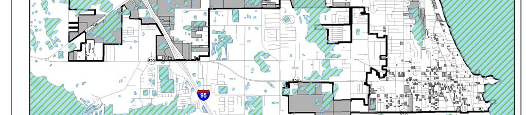
128 EVALUATION AND APPRAISAL REPORT Map 3: Vacant Land Use,

129 EVALUATION AND APPRAISAL REPORT Map 4: Location of Parks 95

130 EVALUATION AND APPRAISAL REPORT Map 5: Location of Development 96
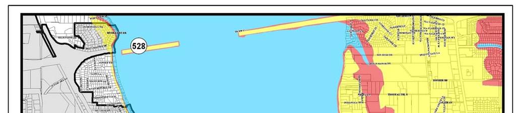
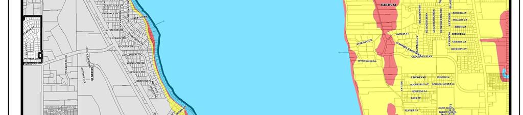
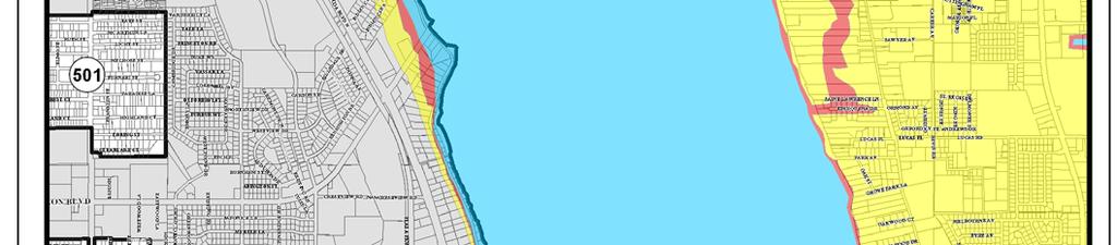
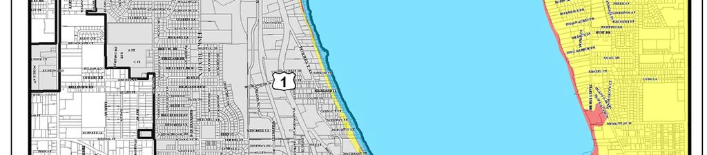
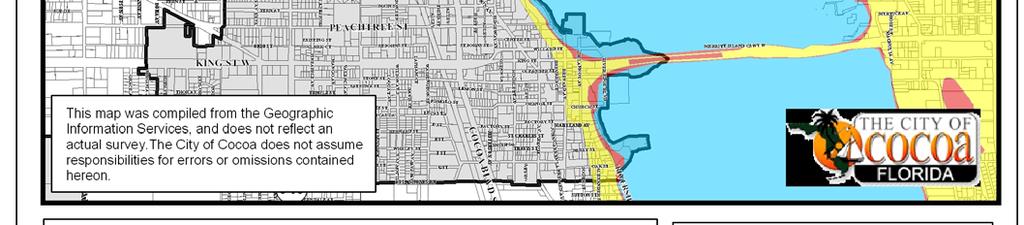
131 EVALUATION AND APPRAISAL REPORT Map 6: Coastal High Hazard Area 97
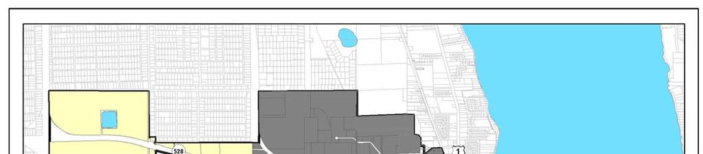

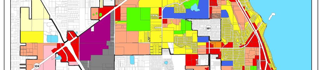
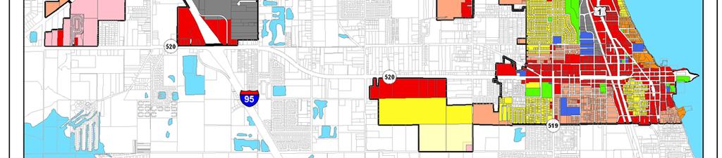
132 EVALUATION AND APPRAISAL REPORT Map 7: Future Land Use Map 98

133 EVALUATION AND APPRAISAL REPORT Map 8: Community Redevelopment Areas 99
RESOLUTION NO ( R)
") RESOLUTION NO. 2013-06- 088 ( R) A RESOLUTION OF THE CITY COUNCIL OF THE CITY OF McKINNEY, TEXAS, APPROVING THE LAND USE ASSUMPTIONS FOR THE 2012-2013 ROADWAY IMPACT FEE UPDATE WHEREAS, per Texas Local
RESOLUTION NO. 2013-06- 088 ( R) A RESOLUTION OF THE CITY COUNCIL OF THE CITY OF McKINNEY, TEXAS, APPROVING THE LAND USE ASSUMPTIONS FOR THE 2012-2013 ROADWAY IMPACT FEE UPDATE WHEREAS, per Texas Local
EVALUATION AND APPRAISAL REPORT OF THE CITY OF FELLSMERE COMPREHENSIVE PLAN APPENDIX D HOUSING ELEMENT
 OBJECTIVE H-A-1: ALLOW AFFORDABLE HOUSING AND ADEQUATE SITES FOR VERY LOW, LOW, AND MODERATE INCOME HOUSING. The City projects the total need for very low, low, and moderate income-housing units for the
Chapter 5: Testing the Vision. Where is residential growth most likely to occur in the District? Chapter 5: Testing the Vision
 Chapter 5: Testing the Vision The East Anchorage Vision, and the subsequent strategies and actions set forth by the Plan are not merely conceptual. They are based on critical analyses that considered how
Housing Characteristics
 CHAPTER 7 HOUSING The housing component of the comprehensive plan is intended to provide an analysis of housing conditions and need. This component contains a discussion of McCall s 1990 housing inventory
Table of Contents. Title Page # Title Page # List of Tables ii 6.7 Rental Market - Townhome and Apart ment Rents
 RESIDENTIAL MONITORING REPORT 2013 Table of Contents Title Page # Title Page # List of Tables ii 6.7 Rental Market - Townhome and Apart ment Rents 21 List of Figures iii 7.0 Other Housing Demands and Trends
CHAPTER Committee Substitute for Committee Substitute for Senate Bill No. 2188
 CHAPTER 2004-372 Committee Substitute for Committee Substitute for Senate Bill No. 2188 An act relating to land development; amending s. 197.502, F.S.; providing for the issuance of an escheatment tax
CONCURRENCY MANAGEMENT SYSTEM ELEMENT
 CONCURRENCY MANAGEMENT SYSTEM ELEMENT TOWN OF HOWEY-IN-THE-HILLS LAKE COUNTY, FLORIDA ADOPTED ON OCTOBER 11, 2010 CONCURRENCY MANAGEMENT SYSTEM ELEMENT TABLE OF CONTENTS A. OVERVIEW OF THE CONCURRENCY
Table of Contents. Appendix...22
 Table Contents 1. Background 3 1.1 Purpose.3 1.2 Data Sources 3 1.3 Data Aggregation...4 1.4 Principles Methodology.. 5 2. Existing Population, Dwelling Units and Employment 6 2.1 Population.6 2.1.1 Distribution
POPULATION FORECASTS
 POPULATION FORECASTS Between 2015 and 2045, the total population is projected to increase by 373,125 residents to reach 2.2 million. Some areas will see major increases, while other areas will see very
CHAPTER 2 VACANT AND REDEVELOPABLE LAND INVENTORY
 CHAPTER 2 VACANT AND REDEVELOPABLE LAND INVENTORY CHAPTER 2: VACANT AND REDEVELOPABLE LAND INVENTORY INTRODUCTION One of the initial tasks of the Regional Land Use Study was to evaluate whether there is
SANTA ROSA IMPACT FEE PROGRAM UPDATE FINAL REPORT. May Robert D. Spencer, Urban Economics Strategic Economics Kittelson & Associates
 SANTA ROSA IMPACT FEE PROGRAM UPDATE FINAL REPORT May 2018 Robert D. Spencer, Urban Economics With: Strategic Economics Kittelson & Associates City of Santa Rosa Impact Fee Program Update TABLE OF CONTENTS
TASK 2 INITIAL REVIEW AND ANALYSIS U.S. 301/GALL BOULEVARD CORRIDOR FORM-BASED CODE
 TASK 2 INITIAL REVIEW AND ANALYSIS U.S. 301/GALL BOULEVARD CORRIDOR FORM-BASED CODE INTRODUCTION Using the framework established by the U.S. 301/Gall Boulevard Corridor Regulating Plan (Regulating Plan),
PRELIMINARY PROJECT PLAN AND REINVESTMENT ZONE FINANCING PLAN FOR PROPOSED TAX INCREMENT REINVESTMENT ZONE NO. 1, CITY OF OAK RIDGE NORTH
 PRELIMINARY PROJECT PLAN AND REINVESTMENT ZONE FINANCING PLAN FOR PROPOSED TAX INCREMENT REINVESTMENT ZONE NO. 1, CITY OF OAK RIDGE NORTH DECEMBER 15, 2014 TABLE OF CONTENTS 1. Overview 1.1 Background...
Town of Prescott Valley 2013 Land Use Assumptions
 Town of Prescott Valley 2013 Land Use Assumptions Raftelis Financial Consultants, Inc. November 22, 2013 Table of Contents Purpose of this Report... 1 The Town of Prescott Valley... 2 Summary of Land Use
TREASURE COAST REGIONAL PLANNING COUNCIL M E M O R A N D U M
 TREASURE COAST REGIONAL PLANNING COUNCIL M E M O R A N D U M To: Council Members AGENDA ITEM 5F From: Date: Subject: Staff July 16, 2010 Council Meeting Local Government Comprehensive Plan Review Draft
Chapter 12 Changes Since This is just a brief and cursory comparison. More analysis will be done at a later date.
 Chapter 12 Changes Since 1986 This approach to Fiscal Analysis was first done in 1986 for the City of Anoka. It was the first of its kind and was recognized by the National Science Foundation (NSF). Geographic
The Onawa and CHAT Report
 The Onawa and CHAT Report Black Hills Energy A Community Housing Assessment Team Study Amy Haase, AICP March 10, 2014 Population Change Onawa, 1960-2010 3,500 3,000 3,176 3,154 3,283 2,936 3,091 2,998
TREASURE COAST REGIONAL PLANNING COUNCIL M E M O R A N D U M. To: Regional Planning Council Members AGENDA ITEM 5D
 TREASURE COAST REGIONAL PLANNING COUNCIL M E M O R A N D U M To: Regional Planning Council Members AGENDA ITEM 5D From: Date: Subject: Staff March 20, 2009 Regional Planning Council Meeting Local Government
Urban Fringe Development Area Project Update And Staff Recommendation
 Urban Fringe Development Area Project Update And Staff Recommendation July 30, 2008 July 30, 2008 Urban Fringe Development Area Project Table of Contents Introduction, Background, and Next Steps 3 Constraints:
Route 6 Corridor Study Bristol Planning Commission Meeting #1. May 25, 2016 FITZGERALD & HALLIDAY, INC. Innovative Planning, Better Communities
 Route 6 Corridor Study Bristol Planning Commission Meeting #1 May 25, 2016 FITZGERALD & HALLIDAY, INC. Innovative Planning, Better Communities Today s Agenda 1. Introductions 2. Study overview Scope Schedule
SECTION 1 INTRODUCTION TO THE PANAMA CITY BEACH COMPREHENSIVE GROWTH DEVELOPMENT PLAN
 1. PURPOSE SECTION 1 INTRODUCTION TO THE PANAMA CITY BEACH COMPREHENSIVE GROWTH DEVELOPMENT PLAN The purpose of the City of Panama City Beach's Comprehensive Growth Development Plan is to establish goals,
4. Parks and Recreation Fee Facility Needs and Cost Estimates Fee Calculation Nexus Findings 24
 TABLE OF CONTENTS CHAPTER PAGE 1. Introduction and Summary of Calculated Fees 1 1.1 Background and Study Objectives 1 1.2 Organization of the Report 2 1.3 Calculated Development Impact Fees 2 2. Fee Methodology
CHAPTER 7 HOUSING. Housing May
 CHAPTER 7 HOUSING Housing has been identified as an important or very important topic to be discussed within the master plan by 74% of the survey respondents in Shelburne and 65% of the respondents in
ECONOMIC CURRENTS. Vol. 5 Issue 2 SOUTH FLORIDA ECONOMIC QUARTERLY. Key Findings, 2 nd Quarter, 2015
 ECONOMIC CURRENTS THE Introduction SOUTH FLORIDA ECONOMIC QUARTERLY Economic Currents provides an overview of the South Florida regional economy. The report presents current employment, economic and real
ECONOMIC CURRENTS. Vol. 4, Issue 3. THE Introduction SOUTH FLORIDA ECONOMIC QUARTERLY
 ECONOMIC CURRENTS THE Introduction SOUTH FLORIDA ECONOMIC QUARTERLY Vol. 4, Issue 3 Economic Currents provides an overview of the South Florida regional economy. The report presents current employment,
2014 Plan of Conservation and Development
 The Town of Hebron Section 1 2014 Plan of Conservation and Development Community Profile Introduction (Final: 8/29/13) The Community Profile section of the Plan of Conservation and Development is intended
3. FISCAL IMPACT ANALYSIS FISCAL IMPACT ANALYSIS 29
 3. FISCAL IMPACT ANALYSIS FISCAL IMPACT ANALYSIS 29 The purpose of fiscal impact analysis is to estimate the impact of a development or a land use change on the budgets of governmental units serving the
Pueblo Regional Development Plan, Addendum
 Pueblo Regional Development Plan, Addendum August 2014 Table of Contents Factual Foundation.1 Land Demand Analysis....1 Population Trends 2 Housing Trends..3 Employment Trends 4 Future Land Demand Summary.5
FUTURE LAND USE. City of St. Augustine Comprehensive Plan EAR-Based Amendments
 FUTURE LAND USE City of St. Augustine Comprehensive Plan EAR-Based Amendments Future Land Use Element FLU Goal To create an environment within the City and adjacent areas in which its residents have the
HOUSING ELEMENT Inventory Analysis
 HOUSING ELEMENT Inventory Analysis 2.100 INVENTORY Age of Housing Stock Table 2.25 shows when Plantation's housing stock was constructed. The latest available data with this kind of breakdown is 2010.
Economic and Fiscal Impact Analysis of Future Station Transit Oriented Development
 Florida Department of Transportation Central Florida Commuter Rail Transit Project Economic and Fiscal Impact Analysis of Future Station Transit Oriented Development Seminole County Summary Report Revised
HOUSING ELEMENT OF THE CITY OF PEMBROKE PINES COMPREHENSIVE PLAN ADOPTION DOCUMENT
 HOUSING ELEMENT OF THE CITY OF PEMBROKE PINES COMPREHENSIVE PLAN RULES 9J-5.010, FAC City of Pembroke Pines, Florida ADOPTION DOCUMENT HOUSING ELEMENT HOUSING ELEMENT ADOPTION DOCUMENT VI. GOALS, OBJECTIVES
Orange Water and Sewer Authority Water and Sewer System Development Fee Study
 Orange Water and Sewer Authority Water and Sewer System Development Fee Study March 6, 2018 March 6, 2018 Mr. Stephen Winters Director of Finance and Customer Service 400 Jones Ferry Road Carrboro, NC
HOUSING ELEMENT GOALS, OBJECTIVES, AND POLICIES
 HOUSING ELEMENT GOALS, OBJECTIVES, AND POLICIES GOAL 1: To promote the preservation and development of high-quality, balanced, and diverse housing options for persons of all income levels throughout the
Return on Investment Model
 THOMAS JEFFERSON PLANNING DISTRICT COMMISSION Return on Investment Model Last Updated 7/11/2013 The Thomas Jefferson Planning District Commission developed a Return on Investment model that calculates
South East Queensland Growth Management Program
 South East Queensland Growth Management Program Acknowledgements Office of Economic and Statistical Research, Demography and Planning Australian Bureau of Statistics Urban Land Development Authority Brisbane
CASE SUMMARY Conditional District Zoning Modification Planning Commission January 9, 2013 CD M1212
 CASE SUMMARY Conditional District Zoning Modification Planning Commission January 9, 2013 CD-3-109-M1212 Jim Diepenbrock, Associate Planner jim.diepenbrock@wilmingtonnc.gov 910-341-3257 Staff recommendation
Chapter 1: Community & Planning Context
 Chapter 1: Community & Planning Context Yesterday, Today & Tomorrow Comprehensive Plan 2040 2 INTRODUCTION The City of Lauderdale is a small town with a long history. Nestled between Saint Paul and Minneapolis,
Town of Bristol Rhode Island
 Town of Bristol Rhode Island Subdivision & Development Review Regulations Adopted by the Planning Board September 27, 1995 (March 2017) Formatted: Highlight Formatted: Font: 12 pt Table of Contents TABLE
CITY OF FARMERSVILLE CITIZEN ADVISORY COMMITTEE AGENDA November 17, :30 P.M. 1, COUNCIL CHAMBERS, CITY HALL
 I. PRELIMINARY MATTERS CITY OF FARMERSVILLE CITIZEN ADVISORY COMMITTEE AGENDA November 17, 2014 6:30 P.M. 1, COUNCIL CHAMBERS, CITY HALL Call to Order, Roll Call, Prayer and Pledge of Allegiance Welcome
SECTION 1 - OVERVIEW OF RESEARCH ACTIVITIES & EXPECTED OUTCOMES
 SECTION 1 - OVERVIEW OF RESEARCH ACTIVITIES & EXPECTED OUTCOMES PURPOSE OF STUDY This Housing Study for Manhattan, Kansas, was commissioned by the City of Manhattan. The Study was conducted by Hanna:Keelan
Document under Separate Cover Refer to LPS State of Housing
 Document under Separate Cover Refer to LPS5-17 216 State of Housing Contents Housing in Halton 1 Overview The Housing Continuum Halton s Housing Model 3 216 Income & Housing Costs 216 Indicator of Housing
Housing Supply Requirements in Ireland s Urban Settlements A Preliminary Update
 Housing Supply Requirements in Ireland s Urban Settlements 2016 2020 A Preliminary Update Page 0 of 8 Key Findings Summary 445 of Ireland s urban settlements were assessed as part of this research. o 272
METHODOLOGY GUIDE VALUING LANDS IN TRANSITION IN ONTARIO. Valuation Date: January 1, 2016
 METHODOLOGY GUIDE VALUING LANDS IN TRANSITION IN ONTARIO Valuation Date: January 1, 2016 August 2017 August 22, 2017 The Municipal Property Assessment Corporation (MPAC) is responsible for accurately assessing
Cedar Hammock Fire Control District
 Cedar Hammock Fire Control District FY 2015 Fire/Rescue Impact Fee Study February 24, 2016 Prepared by: February 24, 2016 Mr. Jeff Hoyle Fire Chief 5200 26 th St W Bradenton, FL 34207 Re: FY 2015 Impact
Appendix 1: Gisborne District Quarterly Market Indicators Report April National Policy Statement on Urban Development Capacity
 Appendix 1: Gisborne District Quarterly Market Indicators Report April 2018 National Policy Statement on Urban Development Capacity Quarterly Market Indicators Report April 2018 1 Executive Summary This
CITY OF CLAREMONT MASTER PLAN 2017 CHAPTER 6: HOUSING
 CITY OF CLAREMONT MASTER PLAN CHAPTER 6: HOUSING Prepared by the Claremont Planning Board and the Claremont Planning and Development Department Vision Claremont Master Plan Chapter 6: Housing Quality housing
City of Palm Bay Stormwater Assessment Program. March 30, 2017
 City of Palm Bay Stormwater Assessment Program March 30, 2017 What is a Stormwater Assessment? A charge imposed against real property to pay for stormwater services provided by the City. 2 Case Law Requirements
City Center Market-Rate Housing Study
 City Center Market-Rate Housing Study OVERVIEW The City of Bellingham, with the assistance of students from Western Washington University, conducted a study of market-rate rental housing during April and
Brevard County Property Appraiser Dana Blickley, CFA
 Brevard County Property Appraiser www.bcpao.us Dana Blickley, CFA BREVARD HOME TO o Kennedy Space Center & Visitor Complex o Canaveral Air Force Station 45 th Space Wing o Patrick Air Force Base o Astronaut
2014 Plan of Conservation and Development. Development Plan & Policies
 The Town of Hebron Section 3 2014 Plan of Conservation and Development Development Plan & Policies C. Residential Districts I. Residential Land Analysis This section of the plan uses the land use and vacant
DRAFT Subject to Modifications
 TREASURE COAST REGIONAL PLANNING COUNCIL M E M O R A N D U M DRAFT Subject to Modifications To: Council Members AGENDA ITEM 5L From: Date: Subject: Staff September 17, 2010 Council Meeting Local Government
DOWNTOWN BEAUMONT CENTRE-VILLE: PARKING MANAGEMENT REPORT
 DOWNTOWN BEAUMONT CENTRE-VILLE: PARKING MANAGEMENT REPORT Prepared for: Prepared by: Town of Beaumont Planning & Development Services WATT Consulting Group Our File: 3364.T01 Date: October 5, 2016 1.0
Coachella Valley Median Detached Home Price May May 2018
 Median Price $450,000 $400,000 Coachella Valley Median Detached Home Price May 2002 - $389,000 $412,000 $350,000 $300,000 $250,000 $200,000 $150,000 CV Detached Median Price 4 % Growth Curve Summary The
Housing Price Forecasts. Illinois and Chicago PMSA, October 2014
 Housing Price Forecasts Illinois and Chicago PMSA, October 2014 Presented To Illinois Association of Realtors From R E A L Regional Economics Applications Laboratory, Institute of Government and Public
DRAFT REPORT. Boudreau Developments Ltd. Hole s Site - The Botanica: Fiscal Impact Analysis. December 18, 2012
 Boudreau Developments Ltd. Hole s Site - The Botanica: Fiscal Impact Analysis DRAFT REPORT December 18, 2012 2220 Sun Life Place 10123-99 St. Edmonton, Alberta T5J 3H1 T 780.425.6741 F 780.426.3737 www.think-applications.com
TREASURE COAST REGIONAL PLANNING COUNCIL M E M O R A N D U M. To: Council Members AGENDA ITEM 4F
 TREASURE COAST REGIONAL PLANNING COUNCIL M E M O R A N D U M To: Council Members AGENDA ITEM 4F From: Date: Subject: Staff January 18, 2008 Council Meeting Local Government Comprehensive Plan Review Draft
Community & Infrastructure Services Committee
 REPORT TO: DATE OF MEETING: September 12, 2016 Community & Infrastructure Services Committee SUBMITTED BY: Alain Pinard, Director of Planning, 519-741-2200 ext. 7319 PREPARED BY: Natalie Goss, Senior Planner,
research highlight Impact of the 2010 Winter Olympic Games on the Vancouver and Sea-to-Sky Housing Markets introduction Methodology
 research highlight November 2006 Socio-economic Series 06-022 Impact of the 2010 Winter Olympic Games on the Vancouver and Sea-to-Sky Housing Markets introduction Cities are increasingly using mega events
PROCEDURE LIST FOR LARGE-SCALE FUTURE LAND USE AMENDMENT
 DEPARTMENT OF COMMUNITY DEVELOPMENT Case # PROCEDURE LIST FOR LARGE-SCALE FUTURE LAND USE AMENDMENT 1. Applicant s portion of request shall be typewritten and signature notarized. a) All forms (Application,
PLANNED UNIT DEVELOPMENTS (Ordinance No.: 3036, 12/3/07; Repealed & Replaced by Ordinance No.: 4166, 10/15/12)
") 159.62 PLANNED UNIT DEVELOPMENTS (Ordinance No.: 3036, 12/3/07; Repealed & Replaced by Ordinance No.: 4166, 10/15/12) A. PURPOSE 1. General. The Planned Unit Development (PUD) approach provides the flexibility
159.62 PLANNED UNIT DEVELOPMENTS (Ordinance No.: 3036, 12/3/07; Repealed & Replaced by Ordinance No.: 4166, 10/15/12) A. PURPOSE 1. General. The Planned Unit Development (PUD) approach provides the flexibility
Memorandum. Kenneth Johnstone, Community Development Director. November 25, 2015 (for December 3 Study Session)
") Memorandum TO: THROUGH: FROM: DATE: SUBJECT: Planning Commission Kenneth Johnstone, Community Development Director Lisa Ritchie, Planner II November 25, 2015 (for December 3 Study Session) Accessory Dwelling
Memorandum TO: THROUGH: FROM: DATE: SUBJECT: Planning Commission Kenneth Johnstone, Community Development Director Lisa Ritchie, Planner II November 25, 2015 (for December 3 Study Session) Accessory Dwelling
METROPOLITAN COUNCIL S FORECASTS METHODOLOGY JUNE 14, 2017
 METROPOLITAN COUNCIL S FORECASTS METHODOLOGY JUNE 14, 2017 Metropolitan Council s Forecasts Methodology Long-range forecasts at Metropolitan Council are updated at least once per decade. Population, households
8Land Use. The Land Use Plan consists of the following elements:
 8Land Use 1. Introduction The Land Use Plan consists of the following elements: 1. Introduction 2. Existing Conditions 3. Opportunities for Redevelopment 4. Land Use Projections 5. Future Land Use Policies
7224 Nall Ave Prairie Village, KS 66208
 Real Results - Income Package 10/20/2014 TABLE OF CONTENTS SUMMARY RISK Summary 3 RISC Index 4 Location 4 Population and Density 5 RISC Influences 5 House Value 6 Housing Profile 7 Crime 8 Public Schools
Affordable Housing Plan
 Affordable Housing Plan CORDOVA HILLS SPECIAL PLANNING AREA 1 Proposed Project Conwy LLC is the master developer ( Master Developer ) of that certain real property in the County of Sacramento ( County
Housing Need in South Worcestershire. Malvern Hills District Council, Wychavon District Council and Worcester City Council. Final Report.
 Housing Need in South Worcestershire Malvern Hills District Council, Wychavon District Council and Worcester City Council Final Report Main Contact: Michael Bullock Email: michael.bullock@arc4.co.uk Telephone:
INDIAN RIVER COUNTY, FLORIDA. The Honorable Members of the Planning and Zoning Commission DEPARTMENT HEAD CONCURRENCE
 Public Hearing Legislative INDIAN RIVER COUNTY, FLORIDA M E M O R A N D U M TO: The Honorable Members of the Planning and Zoning Commission DEPARTMENT HEAD CONCURRENCE Robert M. Keating, AICP; Community
MEMORANDUM. Trip generation rates based on a variety of residential and commercial land use categories 1 Urban form and location factors the Ds 2
 MEMORANDUM Date: September 22, 2015 To: From: Subject: Paul Stickney Chris Breiland and Sarah Keenan Analysis of Sammamish Town Center Trip Generation Rates and the Ability to Meet Additional Economic
HANSFORD ECONOMIC CONSULTING
 HANSFORD ECONOMIC CONSULTING Economic Assessment for Northlight Properties at Old Greenwood April 20, 2015 HEC Project #140150 TABLE OF CONTENTS SECTION Report Contact PAGE iii 1. Introduction and Summary
3804 Wilson Boulevard
 3804 Wilson Boulevard SPECIAL GENERAL LAND USE PLAN STUDY DEPARTMENT OF COMMUNITY PLANNING, HOUSING, & DEVELOPMENT Planning Division 3804 Wilson Boulevard Special GLUP Study a2 3804 Wilson Boulevard Special
EXHIBIT A. City of Corpus Christi Annexation Guidelines
 City of Corpus Christi Annexation Guidelines Purpose: The purpose of this document is to describe the City of Corpus Christi s Annexation Guidelines. The Annexation Guidelines provide the guidance and
METROPOLITAN COUNCIL S FORECASTS METHODOLOGY
 METROPOLITAN COUNCIL S FORECASTS METHODOLOGY FEBRUARY 28, 2014 Metropolitan Council s Forecasts Methodology Long-range forecasts at Metropolitan Council are updated at least once per decade. Population,
The City shall support a suitable mix of housing by: [9J (3)(c)(5)]
![The City shall support a suitable mix of housing by: [9J (3)(c)(5)]](/thumbs/93/111770425.jpg "The City shall support a suitable mix of housing by: [9J (3)(c)(5)]") GOALS, OBJECTIVES AND POLICIES GOAL #1: The City of Titusville shall, through its comprehensive plan, make provision for adequate and affordable housing that meet the physical and social needs of all segments
GOALS, OBJECTIVES AND POLICIES GOAL #1: The City of Titusville shall, through its comprehensive plan, make provision for adequate and affordable housing that meet the physical and social needs of all segments
Comprehensive Plan /24/01
 IV The is a central component of the Comprehensive Plan. It is an extension of the general goals and policies of the community, as well as a reflection of previous development decisions and the physical
The Impact of Market Rate Vacancy Increases Eleven-Year Report
 The Impact of Market Rate Vacancy Increases Eleven-Year Report January 1, 1999 - December 31, 2009 Santa Monica Rent Control Board April 2010 TABLE OF CONTENTS Summary 1 Vacancy Decontrol s Effects on
HOUSING ELEMENT I. GOALS, OBJECTIVES AND POLICIES
 HOUSING ELEMENT I. GOALS, OBJECTIVES AND POLICIES GOAL 1: IN ORDER TO ACHIEVE A BALANCED HOUSING SUPPLY (AND A BALANCED POPULATION AND ECONOMIC BASE), EVERY EFFORT SHOULD BE MADE TO PROVIDE A BROAD RANGE
An Executive Summary. Residential Market Potential
 T1 Residential Market Potential for New Traditional Neighborhoods, Neighborhood Centers, Town Centers, Urban Centers, and The Urban Core T2 October 2004 Conducted by Zimmerman/Volk Associates Inc. Clinton,
IMPACT OF PROPOSED ROLL BACK OF AD VALOREM TAX REVENUES ON FLORIDA S COUNTIES
 IMPACT OF PROPOSED ROLL BACK OF AD VALOREM TAX REVENUES ON FLORIDA S COUNTIES Prepared for Florida Association of Counties 100 South Monroe Street Tallahassee, Florida 32301 Prepared by Fishkind & Associates,
HOUSING ELEMENT GOALS, OBJECTIVES, & POLICIES
 HOUSING ELEMENT GOALS, OBJECTIVES, & POLICIES GOAL H-1: ENSURE THE PROVISION OF SAFE, AFFORDABLE, AND ADEQUATE HOUSING FOR ALL CURRENT AND FUTURE RESIDENTS OF WALTON COUNTY. Objective H-1.1: Develop a
Chapter 4: Housing and Neighborhoods
 Chapter 4: Housing and Neighborhoods Introduction Medina is a growing community that provides a variety of housing types and neighborhood styles while protecting and enhancing the City s open spaces and
Optional Sector Plan 2005 and 2006 Reports
 Division of Community Planning Optional Sector Plan 2005 and 2006 Reports to the Legislative Committee on Intergovernmental Relations Prepared by: Florida Planning & Development Lab Department of Urban
Our Focus: Your Future 2007 YEAR END HOUSING MONITORING AND SUBDIVISION STATUS REPORTS
 Town of Fort Erie Community & Development Services Our Focus: Your Future Prepared for Council-in-Committee Report No. CDS-011-08 Agenda Date February 4,2008 File No. 350204/350308 Subject 2007 YEAR END
MISSISSIPPI GULF COAST APARTMENT SURVEY
 MISSISSIPPI GULF COAST APARTMENT SURVEY PREPARED FOR AND COORDINATED BY GULF REGIONAL PLANNING COMMISSION 1232 PASS ROAD TELEPHONE (228) 864-1167 GULFPORT MISSISSIPPI 39507 PREPARED BY W. S. LOPER AND
Economic Development Action Plan
 Economic Development Action Plan Summary of Vision Profiles Waterfront City Center Entertainment Cultural High Density Comparable Vision Concepts Miami Beach North Beach 1-10 stories (along Collins Ave)
SJC Comprehensive Plan Update Housing Needs Assessment Briefing. County Council: October 16, 2017 Planning Commission: October 20, 2017
 SJC Comprehensive Plan Update 2036 Housing Needs Assessment Briefing County Council: October 16, 2017 Planning Commission: October 20, 2017 Overview GMA Housing Element Background Demographics Employment
2016 Census Bulletin Changing Composition of the Housing Stock
 Metro Vancouver s Role Every five years, the Census of Canada provides benchmark data that is instrumental in analyzing and evaluating local government planning policies and services. Representing member
Detroit Neighborhood Housing Markets
 Detroit Neighborhood Housing Markets Market Study 2016 In 2016, Capital Impact s Detroit Program worked with local and national experts to determine the residential market demand across income levels for
CITY PLANNING COMMISSION COMPREHENSIVE PLAN AND REVIEW CRITERIA
 Page 3 CITY PLANNING COMMISSION COMPREHENSIVE PLAN AND REVIEW CRITERIA COMPREHENSIVE PLAN: The City Planning Commission uses the Comprehensive Plan as a guide in all land use matters. The Plan is available
Comparative Housing Market Analysis: Minnetonka and Surrounding Communities
 Comparative Housing Market Analysis: Minnetonka and Surrounding Communities Prepared by Mark Huonder, Eric King, Katie Knoblauch, and Xiaoxu Tang Students in HSG 5464: Understanding Housing Assessment
Land Use. Land Use Categories. Chart 5.1. Nepeuskun Existing Land Use Inventory. Overview
 Land Use State Comprehensive Planning Requirements for this Chapter A compilation of objectives, policies, goals, maps and programs to guide the future development and redevelopment of public and private
Urban Mixed Use (UMU) Zoning District
 Zoning District") Urban Mixed Use (UMU) Zoning District Prepared by the City of Titusville Community Development Department Contents Purpose... 3 Background... 3 History of the Urban Mixed Use Zoning Classification... 4
Urban Mixed Use (UMU) Zoning District Prepared by the City of Titusville Community Development Department Contents Purpose... 3 Background... 3 History of the Urban Mixed Use Zoning Classification... 4
Assessment Quality: Sales Ratio Analysis Update for Residential Properties in Indiana
 Center for Business and Economic Research About the Authors Dagney Faulk, PhD, is director of research and a research professor at Ball State CBER. Her research focuses on state and local tax policy and
Rough Proportionality and the City of Austin. Prepared for the Austin Bar Association 2016 Land Development Seminar (9/30/16)
") Rough Proportionality and the City of Austin Prepared for the Austin Bar Association 2016 Land Development Seminar (9/30/16) Dan Hennessey, PE Vice President, Director of Transportation/Traffic BIG RED
Rough Proportionality and the City of Austin Prepared for the Austin Bar Association 2016 Land Development Seminar (9/30/16) Dan Hennessey, PE Vice President, Director of Transportation/Traffic BIG RED
Briefing Book. State of the Housing Market Update San Francisco Mayor s Office of Housing and Community Development
 Briefing Book State of the Housing Market Update 2014 San Francisco Mayor s Office of Housing and Community Development August 2014 Table of Contents Project Background 2 Household Income Background and
Census Tract Data Analysis
 Data Analysis Study Area: s within the City of Evansville, Indiana Prepared For Mr. Kelley Coures City of Evansville Department of Metropolitan Development 1 NW MLK Jr. Boulevard Evansville, Indiana 47708
Orange Avenue Corridor Study
 Focusing on Orange Avenue in Winter Park, this study identifies its composition, existing conditions, and examines highest and best use opportunities from a zoning and development perspective. Its aim
MEMORANDUM Planning Commission Travis Parker, Planning Director DATE: April 4, 2018 Lakewood Zoning Amendments Housing and Mixed Use
 MEMORANDUM TO: FROM: Travis Parker, Planning Director DATE: April 4, 2018 SUBJECT: Lakewood Zoning Amendments Housing and Mixed Use In August 2017, the Lakewood Development Dialogue process began with
PART ONE - GENERAL INFORMATION
 Corrected Date: Page 7 Date of Submittal Changed to Coincide with Submittal Date on Page 5 PART ONE - GENERAL INFORMATION A. INTRODUCTION B. Background Miami Shores Village is soliciting responses to this
Initial sales ratio to determine the current overall level of value. Number of sales vacant and improved, by neighborhood.
 Introduction The International Association of Assessing Officers (IAAO) defines the market approach: In its broadest use, it might denote any valuation procedure intended to produce an estimate of market