Planning Commission Revised Preliminary Plan & Final Plat Maplebrooke Reserve Subdivision Montville Township EXECUTIVE SUMMARY
|
|
|
- Meagan Thomas
- 6 years ago
- Views:
Transcription

. The proposal for the 51.")
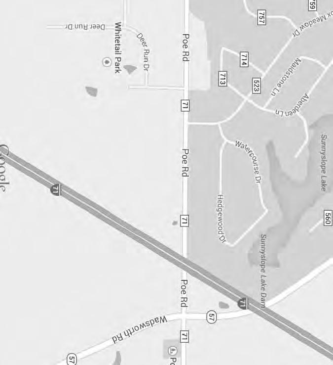
1 Planning Commission Revised Preliminary Plan & Final Plat Maplebrooke Reserve Subdivision Montville Township Meeting: October 5, 2016 App. No.: RPP and FP Applicant: Cambridge Service Co. Engineer: Suhail & Associates Parcel No.: C Site Area: acres Open Space: acres (74%) Sublots: 40 Zoning: R-1, Single-Family Low Density Residential Utilities: Central sanitary sewers and water School Dist.: Medina City Reviewer: Susan Hirsch EXECUTIVE SUMMARY The site is located on the south side of Poe Road west of the I-71 overpass (see location map). The proposal for the acre site includes 40 single family sublots on a public cul-de-sac street. The site will be served by public water and sewer. Recommendation (Revised Preliminary Plan & Final Plat): APPROVAL WITH MODIFICATIONS ADJACENT ZONING/LAND USE Direction Zoning Land Use North R-1 Single-family Low Density Residential Fox Meadows Open Space East R-1 Single-family Low Density Residential Single family homes along Poe Road Agriculture/undeveloped South R-1 Single-family Low Density Residential I-71; Agriculture/undeveloped West R-1 Single-family Low Density Residential Single family homes along Poe Road Medina Bird Club Wooded/ undeveloped Proposal: The applicant proposes to create 40 sublots on a public (60 foot right-of-way [ROW]) permanent cul-de-sac street (see GIS map). The proposed subdivision is to be served by central water and sewer. A detention pond is shown within Block A, an open space block south of Poe Road and west of the cul-de-sac street and in Block C, an open space block south of the homes on the cul-de-sac bulb. There is also a landscaped open space area, Block B, along Poe Road east of the cul-de-sac street. Block C consists of a acres of undisturbed open space and it is located south of the homes on the cul-desac bulb. Block D consisting of acres is the landscaped center of the cul-de-sac bulb, and Blocks E through H are median islands.
2 Maplebrooke Reserve Subdivision, Revised Preliminary Plan and Final Plat Access: Access to the site is provided via Maplebrooke Trace, the proposed permanent cul-desac subdivision street, to Poe Road. The properties on either side of the subject site are either currently developed and/or they have alternate access. There is no requirement for a temporary stub street from the proposed development. Site Conditions: A majority of the site is currently undeveloped and wooded. There is an existing residence that currently accesses Poe Road. The topography is gently rolling; the site slopes upward from Poe Road to its highest point within the open space area south of the proposed cul-de-sac bulb. Several small streams cross the large open space area on the southern portion of the site. Additionally, there may be a small wetlands area within the Open Space Block C at the southern end of the property, and a plugged gas well within Sublot 37. Zoning: The subject property is zoned R-1 Residential District. The Montville Township Zoning Resolution indicates that the purpose of the R-1 District is to provide for the development of low density single-family residential dwellings on subdivided lots with a minimum lot size of two (2) acres, planned neighborhood developments to enable the review of large scale developments, and controlled density planned residential developments to preserve reasonable amounts of open space in the Township. Maplebrooke Reserve Subdivision is proposed to be developed under the Controlled Density regulations. The objective of the Controlled Density PRD is to, provide alternative housing types and the preservation of open space through the flexible arrangement of buildings in a unified development. In the R-1 District a Controlled Density development has a maximum gross density of 0.8 du/acre, a maximum of 4 units on any one acre, and minimum restricted open space of 35%. Background: A Preliminary Plan for this property, under the name Oak Lane Subdivision, was approved with modifications by the Planning Commission on August 6, Subsequently, a Final Plat for Maplebrooke Reserve was submitted for the June 5, 2015 Planning Commission meeting and then continued to the July meeting due to unresolved storm water discharge issues. The Final Plat was not resubmitted until now along with the Revised Preliminary Plan. Revised Preliminary Plan Agency Comments: Italicized text indicates quotations from submitting agency comments. Medina County Health Department, Christine Fienga, 9/23/2016. This subdivision will be serviced by sanitary sewer and public water so our office has no further comments. Columbia Gas, Russ Johnson, 9/20/2016. Columbia Pipeline Group has no facilities impacted by this project. Ohio Department of Transportation (ODOT), Jared Feller, 9/9/2016. Since Maplebrooke Reserve does not have direct access to a state highway, ODOT has no objections. Medina County Soil and Water Conservation District (MCSWCD), Jim Dieter, 7/29/2014, No additional comments. Planning Commission Page 2 of 6 October 5, 2016
3 Maplebrooke Reserve Subdivision, Revised Preliminary Plan and Final Plat 7/1/2014. Maplebrooke Reserve Subdivision is located off of Poe Rd west of the I-71 over pass. It has proposed 40 single family homes on approximately acres. An additional acres are proposed as open space. Houses will be serviced by public water and sewer. Proposed detention basin at the northwest corner of the subdivision is very close to the west property line and the road right of way. Township zoning setbacks may require a greater setback distance that what is proposed. This area is part of the open space; township will need to address this location. A minimum of a 15 foot buffer is recommended to perform any maintenance. The soil in this area is Wadsworth silt loam. Wadsworth Silt loam has seasonal high water table and is moderately slow permeability. Houses with basements may have limitations. The southern section of this development is best suited as open space due to its natural features. The trees may also buffer some highway noise. Open space adjacent to the homes along the south end of the development should be marked so that the owner does not encroach into the open space area. Will the proposed open space be maintained by a Homeowners Association (HOA) and what would be the plans to maintain this open space? Sanitary Engineer, Jeremy Sinko, 9/15/2016, APPROVED. Highway Engineer, Andy Conrad, 9/12/2016. CONDITIONAL APPROVAL. 1. Show Fox Meadow Drive and the Whitetail Crossing Subdivision. 2. Drainage assessments are required. 3. Developer responsible for sidewalk installation along the frontage of all Blocks. 4. Show easement for relocated gas line & gas line owner contact information. Montville Township, Paul Jeffers, Zoning Inspector, 9/22/2016. CONDITIONAL APPROVAL. Montville Twp. Zoning Commission has approved the preliminary plans for this development. There are some outstanding items that need to be complied to prior to final approval: 1. Landscaping plan for the entrance due to the reconfiguration of the detention basins. 2. Center islands within the roadway are not engineered to allow for snow removal. 3. Plant material for center islands, recommend low lying plantings. 4. Dedicated area for USPS Cluster Unit Mailboxes must be shown. Staff Comments: 1. The currently submitted Revised Preliminary plan reflects the following changes from the August 2014 approved Preliminary Plan: a. The addition of a storm water management easement within Block C at the southern end of the cul-de-sac. b. An increase in the size of the detention pond on Block A. c. Addition of pedestrian access to the Block C open space area; a 20 foot area between Sublots 15 and 16 north side of Maplebrooke Trace and a 15 foot area between Sublots 26 and 27 south of Maplebrooke Trace. d. Subsequent changes to the sublot widths to allow for the above changes. 2. Label the detention pond in Block C, and indicate existing structures that are to be removed. Planning Commission Page 3 of 6 October 5, 2016
4 Maplebrooke Reserve Subdivision, Revised Preliminary Plan and Final Plat 3. Label all Blocks as Open Space. 4. The proposed subdivision is consistent with Montville Township zoning. 5. The proposed subdivision is consistent with the Montville Township Comprehensive Plan. 6. Highway Engineer s comments must be addressed prior to Director signing the Final Plat. 7. Tax Maps comments must be addressed 8. Applicant must submit documentation of notification to the US Army Corps of Engineers of the proposed Maplebrooke Reserve Subdivision. 9. Draft HOA documents addressing maintenance of the open space blocks and the detention ponds have been submitted for review by the Prosecutor s Office and the Township. HOA documents must be approved by the Prosecutor s Office and the Township prior to Final Plat approval. Staff Recommendation: Staff recommends that the Medina County Planning Commission APPROVE WITH MODIFICATIONS the Revised Preliminary Plan for Maplebrooke Reserve Subdivision. The required modifications include the following: 1. Label the detention pond in Block C, and indicate existing structures that are to be removed. 2. Label all Blocks as Open Space. 3. Address Highway Engineer s comments. 4. Tax Maps comments must be addressed 5. Applicant must submit documentation of notification to the US Army Corps of Engineers of the proposed Maplebrooke Reserve Subdivision. 6. HOA documents addressing maintenance of the open space blocks and the detention pond must be approved by the Prosecutor s Office and the Township prior to Final Plat approval. Final Plat Agency Comments: Italicized text indicates quotations from submitting agency comments. Sanitary Engineer, Jeremy Sinko, 9/15/2016, CONDITIONAL APPROVAL. There are a few revisions that need to be made to the Final Plat; the requested revisions have been ed to the engineer. Also, Medina County Prosecutor s Office is reviewing the Underground Easement language to determine if the MCSE is at risk. Once these issues are resolved, the MCSE will sign the plat. Ohio Department of Transportation (ODOT), Jared Feller, 9/9/2016. Since Maplebrooke Reserve does not have direct access to a state highway, ODOT has no objections. Highway Engineer, Andy Conrad, 9/12/2016. CONDITIONAL APPROVAL. 1. Show existing and proposed monuments. 2. Provide basis of bearing. 3. Tie down easements. 4. Are you proposing a gas well easement or no build area? Clarify. 5. Provide easement to relocated gas line (provide name of gas company). Planning Commission Page 4 of 6 October 5, 2016
5 Maplebrooke Reserve Subdivision, Revised Preliminary Plan and Final Plat 6. Provide dimensions along centerline to locate Blocks. 7. Provide survey monument legend. 8. Poe road clarification 9. Revise Block A & B language. 10. Show I-71 right-of-way. Tax Maps, Beth Mika, 9/26/2016. CONDITIONAL APPROVAL 1 It is recommended that you submit the final subdivision plat to Tax Maps for review, before obtaining signatures. 2. Remove existing parcel numbers from final plat. 3. Subject to all Tax Map Dept. comments from previous Planning Dept. reviews and/or extension requests. 4. Subject to Medina County Engineer Land Conveyence Standards found at: and to all Tax Map Dept. comments from previous Planning Dept. reviews. Staff Comments: 1. The following required data/information was not provided on or with the Final Plat (Subdivision Regulation section references are included): a. An original mylar of the Final Plat. 404(D)(2)d. Submit the original mylar. b. Total site data - Including number of residential lots. 404(D)(2) f.13. Add the number of lots to the site data table. c. Signature and seal of a Registered Surveyor on each sheet. 404(D)(2)f.16. Include the surveyor s signature on each sheet of the plat. d. Notarized certification by the owner or owners of the subdivision. 404(D)(2)f.17. Provide notarized signatures of the owners. e. Certification from the Township that the Final Plat as submitted is in compliance with local zoning standards and requirements. Such Certification shall be in the form of an executed signature block on the original mylar and signed by at least two of the Township Trustees. 404(D)(2)g.1. Provide signatures of at least two of the township trustees. f. Certification of County Engineer that all required improvements have been satisfactorily installed or financial guarantees have been provided to cover all construction. 404(D)(2)g.4. Provide the signature of the Highway Engineer. g. Acceptance of offers of dedication by County Commissioners, when all improvements have been constructed, or financial guarantees and construction agreements have been approved. 404(D)(2)g.4. Provide the signatures of the County Commissioners. h. For new subdivisions with planned public improvements written approval by the applicable U.S. Army Corps of Engineers District Office (USACE), or other applicable agency, is required before acceptance of public improvements or dedication of public easements. 404(D)(2)g.9. Provide written approval from the USACE. i. Covenants and Restrictions and/or deed restrictions including establishment of Owners Association, and if applicable, assignment of responsibilities, ownership of common areas, and any other areas of responsibility or concern relative to Planning Commission Page 5 of 6 October 5, 2016
6 Maplebrooke Reserve Subdivision, Revised Preliminary Plan and Final Plat public or private maintenance of areas or facilities shall be approved by the Medina County Prosecutors Office as to form and correctness. 404(D)(2)h. Provide evidence of Prosecutor s Office approval of the submitted homeowner s association (HOA) documents. j. Protective covenants, conditions and restrictions, if any, shall be either shown on the plat or recorded separately as a separate instrument, provided volume and page reference thereto is indicated on the plat. 404(D)(2)h. Provide recorded HOA document reference notation on the plat. 2. Label all Blocks as Open Space. 3. There is a plugged gas well on Sublot 37. In November of 2015 the applicant was granted a variance to permit a 20 foot setback from the well rather than the required 50 foot setback. The wording on the plat, stating that there is a 20 foot easement needs to be clarified. Suggest calling it a setback rather than an easement. 4. The proposed Final Plat fulfills the purpose and intent and meets the standards and requirements of the Subdivision Regulations per 404(D)(5)b.1. and The proposed Final Plat is in substantial conformance with the submitted Revised Preliminary Plan per 404(D)(5)b The proposed Final Plat appears to be in substantial conformance with the Township Zoning Resolution per 404(D)(5)b Upon receipt of Highway Engineer s certification of approval of the construction drawings, the Director is authorized to execute the Final Plat on behalf of the Planning Commission upon certification by the Highway Engineer that the construction is complete or that adequate financial guarantees have been provided per 404(D)(5)b.7. Staff Recommendation: Staff recommends that the Medina County Planning Commission APPROVE WITH MODIFICATIONS the Final Plat for Maplebrooke Reserve Subdivision subject to the following: 1. Satisfy the Highway Engineer, Sanitary Engineer and Tax Maps conditions of approval as listed above. 2. Label all Blocks as Open Space. 3. Clarify that 20 foot easement from the plugged well on Sublot 37 is a setback. 4. Provide the above listed required data/information on or with the original Mylar of the Final Plat. 5. Submit documentation of notification to the US Army Corps of Engineers of the proposed Maplebrooke Reserve Subdivision. 6. HOA documents addressing maintenance of the open space blocks and the detention ponds must be approved by the Prosecutor s Office and the Township prior to Final Plat approval. The Director will sign the Final Plat upon satisfaction of all above conditions. R:\arcview\wp_planning\major_subdivisions\2016\maplebrook_res_final\working_docs\Maplebrooke_Reserve_finalplat_ FP.doc.docx Planning Commission Page 6 of 6 October 5, 2016
7 TORINGTON DRIVE WADSWORTH ROAD FOXGLOVE DRIVE WADSWORTH ROAD PEBBLE COURT PERIAN COURT MONTAUK POINTE INTERSTATE HIGHWAY 71 RIDGESTONE WAY POE ROAD ANTLER TRAIL FOX GLEN DRIVE R-1 POE ROAD DEER TAIL DRIVE FOX MEADOW DRIVE DEER RUN DRIVE MAIDSTONE LANE H OUNDS R UN DRIVE FAWNDALE DRIVE FOX MEADOW DRIVE WATERCOURSE DRIVE HEDGEWOOD DRIVE POE ROAD INTERSTATE HIGHWAY 71 Visit us on the web at Maplewood Reserve Rev. Pre. Plan & Final Plat App. 091 & Montville Township Meeting Date: 10/5/2016 Zoning: R-1 Area: acres Sublots: 40 O 1:12, ,000 Feet
8 DEER RUN DRIVE DEER RUN DRIVE R-1 1 FAWNDALE DRIVE FAWNDALE DRIVE POE ROAD POE ROAD Visit us on the web at Maplewood Reserve Rev. Pre. Plan & Final Plat App. 091 & Montville Township Meeting Date: 10/5/2016 Zoning: R-1 Area: acres Sublots: 40 O 1:5, Feet
9

10

11 SURVEYOR'S CERTIFICATE: BEING PART OF LOT NO.'S 39, 53 AND 54 IN THE TOWNSHIP OF MONTVILLE, COUNTY OF MEDINA, STATE OF OHIO AND CONTAINING ACRES OF LAND OF WHICH ACRES IS IN BLOCK 'A', ACRES IS IN BLOCK 'B', ACRES IS IN BLOCK 'C', ACRES IS IN BLOCK 'D', ACRES IS IN BLOCK 'E', ACRES IS IN BLOCK 'F', ACRES IS IN BLOCK 'G', ACRES IS IN BLOCK 'H', ACRES IS IN BLOCK 'I', ACRES IS IN BLOCK 'J', ACRES ARE IN STREETS, ACRES ARE WITHIN THE SUBDIVISION OF LOTS 1 THRU 40. DIMENSIONS SHOWN ON THIS PLAT ARE EXPRESSED IN FEET AND DECIMAL PARTS THEREOF AND ALL BEARINGS ARE TO AN ASSUMED MERIDIAN AND ARE USED TO INDICATE ANGLES ONLY. PERMANENT MONUMENTS WERE FOUND OR WILL BE SET AT ALL POINTS INDICATED HEREON. I HEREBY CERTIFY THAT I HAVE SURVEYED THE PREMISES AND PREPARED THIS PLAT AND THAT SAID PLAT IS CORRECT. MAPLEBROOKE RESERVE SITUATED IN THE TOWNSHIP OF MONTVILLE, COUNTY OF MEDINA AND STATE OF OHIO AND KNOWN AS BEING PART OF LOT NO.'S 39, 53 AND 54 OF MONTVILLE TOWNSHIP TOWNSHIP TRUSTEES OF MONTVILLE TOWNSHIP HERE BY CERTIFY THAT THIS PLAT MEETS ALL REQUIREMENTS OF THE TOWNSHIP ZONING RESOLUTION THIS DAY OF, 20. THIS PLAT IS APPROVED BY THE MEDINA COUNTY PLANNING COMMISSION, THIS DAY OF, 20. DIRECTOR CHAIRPERSON THIS PLAT IS APPROVED BY THE COUNTY ENGINEER OF THE MEDINA COUNTY, THIS DAY OF, 20. CHAIRMEN TRUSTEES TRUSTEE ALL REQUIRED IMPROVEMENTS HAVE BEEN SATISFACTORILY INSTALLED AND ADEQUATE FINANCIAL GUARANTEES HAVE BEEN APPROVED BY THE MEDINA COUNTY ENGINEER COUNTY ENGINEER THIS PLAT IS APPROVED BY THE MEDINA COUNTY SANITARY ENGINEER THIS DAY OF, 20. (SANITARY SEWER AVAILABLE) WADSWORTH RD FOX MEDADOW DR ABORDEN LN MAIDSTONE LN THIS PLAT IS APPROVED FOR TRANSFER THIS DAY OF, 20. SANITARY ENGINEER WATERCOURSE DR. RECEIVED FOR TRANSFER THIS DAY OF 20. TAX MAP DRAFTSMAN HEDGE WOOD DR COUNTY AUDITOR RECEIVED FOR RECORDING THIS DAY OF 20. AT RECORDED THIS DAY OF 20 IN VOL. PAGE FEE OWNERS CERTIFICATE, ACCEPTANCE & DEDICATION POE ROAD WE, THE UNDERSIGNED OWNERS, HEREBY CERTIFY THAT THE ATTACHED PLAT CORRECTLY REPRESENTS MAPLEBROOKE RESERVE, A SUBDIVISION OF LOTS 1 TO 40 INCLUSIVE, AND DO HEREBY ACCEPT THIS PLAT OF SAME AND DEDICATE TO PUBLIC USE ALL STREETS SHOWN HEREON AND DESIGNATED AS MAPLEBROOKE TRACE 60 FT. WIDE. WE GRANT ALL EASEMENTS FOR SEWERS AND DRAINAGE SHOWN HEREON TO PUBLIC USE. THE UNDERSIGNED FURTHER AGREES THAT ANY USE OF IMPROVEMENTS MADE ON THIS LAND SHALL BE IN CONFORMITY WITH ALL EXISTING ZONING, PLATTING, HEALTH OR OTHER LAWFUL RULES AND REGULATIONS OF THE TOWNSHIP OF MONTVILLE, OHIO, FOR THE BENEFIT OF THEMSELVES AND ALL OTHER SUBSEQUENT OWNERS OR ASSIGNS TAKING TITLE FROM, UNDER OR THROUGH THE UNDERSIGNED. DEER RUN DR SITE SR 71 UNDERGROUND EASEMENT COUNTY RECORDER THE OWNERS OF THE WITHIN PLATTED LAND DO HEREBY GRANT UNTO THE OHIO EDISON CO., G.T.E. AND CABLEVISION, THEIR SUCCESSORS AND ASSIGNEES (HERE IN AFTER REFERRED TO AS THE GRANTEES) A PERMANENT RIGHT-OF-WAY EASEMENT TWELVE FEET (12') IN WIDTH OVER, UNDER, AND THROUGH ALL SUBLOTS AND ALL LANDS SHOWN HEREON PARALLEL AND ADJACENT TO ALL STREET LINES (UNLESS SHOWN OTHERWISE ON THE PLAT) TO CONSTRUCT, PLACE, OPERATE, MAINTAIN, REPAIR, RECONSTRUCT AND RELOCATE SUCH UNDERGROUND ELECTRIC AND COMMUNICATION CABLES, DUCTS, CONDUITS, SURFACE OR BELOW GROUND MOUNTED TRANSFORMERS, PEDESTALS, CONCRETE PADS AND OTHER FACILITIES AS WITNESS STATE OF OHIO ) COUNTY OF MEDINA ) S S OWNER VICINITY MAP NOT TO SCALE ARE DEEMED NECESSARY OR CONVENIENT FOR THE GRANTEES TO DISTRIBUTE AND TRANSMIT ELECTRICITY AND COMMUNICATIONS SIGNALS FOR PUBLIC AND PRIVATE USE AT SUCH LOCATIONS AS GRANTEES MAY DETERMINE UPON, WITHIN AND ACROSS THE EASEMENT PREMISES. SAID EASEMENT SHALL INCLUDE THE RIGHT TO INSTALL, MAINTAIN, REPAIR AND AUGMENT ELECTRIC AND COMMUNICATIONS FACILITIES OUTSIDE THE ABOVE DESCRIBED PREMISES AND SHALL ALSO INCLUDE THE RIGHT OF ACCESS, INGRESS AND EGRESS TO AND FROM ANY OF THE WITHIN DESCRIBED PREMISES FOR THE PURPOSE OF EXERCISING ANY OF THE EASEMENT RIGHTS INDICATED HEREIN. GRANTEES SHALL AT THEIR EXPENSE RESTORE THE LAND TO ITS CONDITION AS IT EXISTED IMMEDIATELY PRIOR TO THE WORK PERFORMED BY GRANTEES, EXCEPT GRANTEES SHALL NOT BE RESPONSIBLE FOR REPLACING OR REPAIRING ANY PERMANENT STRUCTURE, TREES OR SHRUBS WHICH ARE LOCATED WITHIN THE EASEMENT BOUNDARIES AND ARE DAMAGED OR REMOVED AS A RESULT OF WORK PERFORMED AS PROVIDED FOR HEREIN BY GRANTEES. THE SUBLOTS SHALL BE RESTRICTED TO UNDERGROUND UTILITY SERVICE. BEFORE ME, A NOTARY PUBLIC IN AND FOR SAID COUNTY AND STATE, DID PERSONALLY APPEAR THE ABOVE NAMED AND WHO ACKNOWLEDGED THE MAKING OF THE FOREGOING INSTRUMENT AND THE SIGNING OF THIS PLAT TO BE THEIR OWN FREE ACT AND DEED. OWNER IN TESTIMONY THEREOF I HAVE HEREUNTO SET MY HAND AND OFFICIAL SEAL THIS DAY OF NOTARY PUBLIC MY COMM. EXPIRES MAPLEBROOKE RESERVE TITLE SHEET OF 4
12 STORMWATER MANAGEMENT EASEMENT S82 18' 41"E S63 45' 31"E S26 39' 09"E S45 12' 20"E S49 58' 39"W S35 31' 05"W 15,245 S.F AC. N1 35' 17"W N30 44' 45"W S31 25' 29"W ' DEED, ' MSD. S/L 20 15,245 S.F AC. S/L 22 S16 13' 07"W S9 06' 59"E N72 37' 26"E C17 15,245 S.F AC. S 01 01'10" W ' MSD. C16 C15 N67 51' 07"W C18 S/L 23 S/L 19 12,606 S.F. 14,462 S.F AC AC. C19 C14 N79 52' 10"W S4 21' 35"W R26' S11 51' 37"E S0 40' 59"W S7 24' 11"W S24 15' 53"W S78 02' 57"E C13 S/L S/L 18 12,565 S.F. 13,007 S.F. C AC AC. C21 BLOCK 'D' 2124 S.F A.C. C12 THE MEDINA BIRD CLUB INC. N83 31' 22"W S82 56' 35"E C11 P.P. # C DATE: BLOCK 'C' 1,557,650 S.F AC S/L S/L 17 11,813 S.F. 12,350 S.F AC. S0 21' 40"W S23 28' 01"W C22 C23 C3 S1 04' 18"W C AC. N87 16' 18"W S87 36' 28"E C9 S/L 26 11,465 S.F AC. 50' REAR SETBACK S/L 16 11,401 S.F AC. S 89 47' 46" E ' REC. & MSD. S/L 15 S/L 27 11,196 S.F AC AC. S/L 14 S/L 28 11,185 S.F AC AC. S/L 13 10,988 S.F AC. S/L 29 11,173 S.F AC. 50' REAR SETBACK S/L 12 S/L 30 11,161 S.F AC. 11,015 S.F AC. S/L 11 11,041 S.F. S/L 31 11,149 S.F AC AC. S/L S/L 32 11,137 S.F AC. 11,067 S.F AC. 40' BUILDING SETBACK 12' UTILITY EASEMENT 36.65' 25.82' 20.00' BLOCK 'E' 146 S.F. C34 C35 C36 12' A.C. 12' MAPLEBROOKE TRACE (60') 45' 12' C31 45' 12' 12' BLOCK 'F' 12' BLOCK 'G' 146 S.F. 146 S.F ' C32 C A.C A.C ' 75.00' 75.00' 17.47' 15' SANITARY EASEMENT 40' BUILDING SETBACK 5.31' S 89 47' 46" E ' REC. & MSD ' ' STORM EASEMENT S/L 9 11,094 S.F. S/L 33 11,125 S.F AC AC N 00 08'20" W ' REC., ' MSD. S/L 34 11,113 S.F AC. 11,120 S.F AC S/L 7 11,147 S.F AC. S/L 35 11,101 S.F AC. N 00 01'54" E ' REC. & MSD. 30' DRAINAGE EASEMENT S/L 6 11,173 S.F AC. S/L 36 11,881 S.F AC. 50' REAR SETBACK 75.00' S/L 5 11,200 S.F AC. S/L 37 11,868 S.F AC ' S/L 4 11,226 S.F. S/L 38 11,064 S.F AC AC. 20' STM. EASEMENT S/L 3 S/L 39 11,019 S.F AC. 30' DRAINAGE EASEMENT 50' REAR SETBACK AC S/L 40 S/L 2 12,212 S.F. 40' BUILDING SETBACK C24 C25 C26 S0 10' 13"W ' STM. EASEMENT S0 10' 13"W PENNYPACKER A. CLARK TRUSTEE P.P. # C DATE: ' STORM SEWER EASEMENT EDWARD J. & CANDALE L. TREMP P.P. # C DATE: WHITE TAIL CROSSING LLC. P.P. # C DATE: ' C8 S86 46' 44"E C7 10,652 S.F AC ' AC. S81 56' 43"E ,030 S.F. S/L 1 C AC ' N77 52' 56"W ' C6 OPEN SPACE BLOCK "A" 54,890 S.F A.C. ENTIRE BLOCK "A" ENCOMPASS STORM WATER MANAGEMENT EASEMENT C2 C28 S25 06' 57"W N25 04' 48"E C37 BLOCK 'H' 146 S.F. N18 46' 34"E A.C. OPEN SPACE BLOCK "B" 31,384 S.F A.C. ENTIRE BLOCK "B" ENCOMPASS STORM WATER MANAGEMENT EASEMENT C38 BLOCK 'I' 146 S.F A.C ' C5 BLOCK 'J' 146 S.F A.C. C40 S89 59' 06"W C4 O.L. 40 O.L. 53 S89 54' 44"E C C42 S 89 54' 44" E S 89 54' 44" E 380' 40.00' O.L. 41 O.L ' REC. & MSD. REC. & MSD. POE ROAD C43 C29 S18 54' 47"W C44 C30 C39 C41 S12 39' 54"W N12 36' 57"E FOX MEADOW DRIVE C.F. MEADOW ARCIS LLC P.P. # A N0 10' 13"E EDWARD J. & CANDALE L. TREMP P.P. # C DATE: Curve Table Curve Table Curve Table Curve # Length Radius Delta Chord Direction Chord Length Tangent Curve # Length Radius Delta Chord Direction Chord Length Tangent Curve # Length Radius Delta Chord Direction Chord Length Tangent C ' ' 26 47' 16" N13 33' 51"E ' 63.10' C ' 40.00' 53 02' 46" N34 17' 03"E 35.72' 19.96' C41 S78 13' 28"E C ' ' 26 47' 16" S13 33' 51"W ' ' C ' ' 15" N7 24' 32"E 11.92' 5.96' C42 N80 23' 12"W C ' ' 12 38' 01" N6 29' 14"E ' ' C ' ' 4 39' 53" N4 43' 29"E 78.95' 39.51' C ' ' 1 26' 09" N21 40' 45"E 10.00' 5.00' C ' 22.00' 82 41' 17" S48 44' 38"W 29.07' 19.36' C ' ' 2 13' 19" N1 16' 53"E 37.61' 18.81' C ' ' 2 09' 44" N15 01' 08"E 10.00' 5.00' C ' ' 19 59' 45" N17 23' 53"E ' 52.71' C ' ' 3 03' 03" S1 41' 45"W 42.06' 21.04' C ' ' 17 33' 45" N18 36' 52"E ' ' C ' ' 4 50' 01" S5 38' 17"W 66.63' 33.34' C ' ' 5 32' 11" S7 03' 54"W 70.51' 35.30' C ' ' 4 52' 21" S10 29' 28"W 67.16' 33.61' C ' ' 4 07' 36" S2 14' 01"W 52.57' 26.30' C ' ' 13 34' 58" S19 43' 07"W ' 94.08' C9 C10 C ' 67.40' 29.22' ' ' ' 2 00' 28" 3 44' 56" 1 37' 32" N1 26' 57"E N4 36' 10"E N7 17' 24"E 45.98' 67.38' 29.22' 22.99' 33.71' 14.61' C29 C30 C ' 38.89' ' 22.00' 15 08' 58" ' 22" S18 56' 07"W S39 16' 33"E 60.90' 34.02' 30.72' 26.82' Line Table Line # Length Direction C ' 40.00' 48 10' 04" S15 58' 52"E 32.65' 17.88' C32 C ' 8 24' 45" N35 51' 32"W 10.27' 5.15' C33 C ' 53 48' 03" N4 45' 08"W 63.34' 35.51' C34 C ' 37 06' 22" N40 42' 04"E 44.55' 23.49' C35 C ' 29 09' 28" N73 49' 59"E 35.24' 18.21' C36 C ' 37 06' 22" S73 02' 06"E 44.55' 23.49' C37 S65 15' 02"E C ' 37 06' 22" S35 55' 44"E 44.55' 23.49' C38 N67 24' 46"W C ' 41 36' 27" S3 25' 40"W 49.72' 26.60' C39 S70 26' 23"E C ' 36 34' 32" S42 31' 10"W 43.93' 23.13' C40 N76 03' 43"W DESIGNED BY CHECKED BY REVIEWED BY MAPLEBROOKE RESERVE PREPARED FOR OAK LANE ASSOCIATES LTD. 130 WEST STREETSBORO STREET HUDSON, OHIO PH. NO. (330) DATE PLAT S&S JOB NO. SHEET NO. NO. DATE BY SCALE OF 4 REVISIONS
13 STORMWATER MANAGEMENT EASEMENT SOCIETY FOR HANDICAPPED CHILDREN OF MEDINA COUNTY P.P. # C DATE: N 00 24'20" W ' REC. & MSD. PFO1C- EMERGENT WETLAND AS PER NATIONAL WETLANDS INVENTORY MAP O.L. 39 O.L. 40 N 89 45'21" W ' REC. & MSD ' DEED, ' MSD. THE MEDINA BIRD CLUB INC. P.P. # C DATE: OAK LANE ASSOCIATES LTD. P.P. # C DATE: O.L. 54 O.L. 53 S26 39' 09"E S9 06' 59"E BLOCK 'C' 1,557,650 S.F AC. S0 40' 59"W S7 24' 11"W S24 15' 53"W S 89 47' 46" E ' REC. & MSD. N 30 52'34" E ' REC., ' MSD. BLOCK 'C' 1,557,650 S.F AC. OAK LANE ASSOCIATES LTD. P.P. # C DATE: S82 18' 41"E S63 45' 31"E S45 12' 20"E S35 31' 05"W 15,245 S.F AC. N1 35' 17"W S/L 20 N72 37' 26"E 15,245 S.F AC. C17 C16 C18 S/L 19 14,462 S.F AC. C19 R26' S78 02' 57"E S/L 18 13,007 S.F AC. C20 C21 BLOCK 'D' 2124 S.F A.C. S82 56' 35"E S23 28' 01"W S/L 17 C22 C23 C3 12,350 S.F AC. S87 36' 28"E C24 S/L 16 11,401 S.F AC. 5.31' 36.65' 20.00' S/L AC INTERSTATE 71 S 89 53' 36" W 45.62' REC. & MSD. S 01 01'10" W ' MSD. S49 58' 39"W N30 44' 45"W S31 25' 29"W S/L 22 S16 13' 07"W C15 15,245 S.F AC. N67 51' 07"W S/L 23 12,606 S.F. C AC. N79 52' 10"W S4 21' 35"W S11 51' 37"E C13 S/L 24 12,565 S.F. C AC. C11 N83 31' 22"W S/L C10 11,813 S.F AC. S0 21' 40"W S1 04' 18"W N87 16' 18"W C9 S/L 26 11,465 S.F AC. 50' REAR SETBACK S0 10' 13"W ' 22.25' S 89 47' 46" E ' S/L 27 REC. & MSD. 11,196 S.F AC ' EDWARD J. & CANDALE L. TREMP P.P. # C DATE: INTERSTATE 71 DESIGNED BY CHECKED BY REVIEWED BY MAPLEBROOKE RESERVE PREPARED FOR OAK LANE ASSOCIATED LTD. 130 WEST STREETSBORO STREET HUDSON, OHIO PH. NO. (330) DATE REMAINDER PARCEL SHEET 1 S&S JOB NO. SHEET NO. NO. DATE BY SCALE OF 4 REVISIONS
14 MWATER GEMENT MENT SOCIETY FOR HANDICAPPED CHILDREN OF MEDINA COUNTY P.P. # C DATE: SOCIETY FOR HANDICAPPED CHILDREN OF MEDINA COUNTY P.P. # C DATE: N 00 24'20" W ' REC. & MSD. BATTIG E. MARJORIE P.P. # C DATE: N 00 18'07" W ' MSD. N 89 41'53" E ' MSD. PFO1C- EMERGENT WETLAND AS PER NATIONAL WETLANDS INVENTORY MAP O.L. 39 O.L. 40 N 89 45'21" W ' REC. & MSD ' DEED, ' MSD. THE MEDINA BIRD CLUB INC. P.P. # C DATE: OAK LANE ASSOCIATES LTD. P.P. # C DATE: O.L. 54 O.L. 53 N 30 52'34" E ' REC., ' MSD. BLOCK 'C' 1,557,650 S.F AC. OAK LANE ASSOCIATES LTD. P.P. # C DATE: S82 18' 41"E S63 45' 31"E S45 INTERSTATE 71 S49 S 89 53' 36" W 45.62' REC. & MSD. S 01 01'10" W ' MSD. EDWARD J. & CANDALE L. TREMP P.P. # C DATE: INTERSTATE 71 DESIGNED BY CHECKED BY REVIEWED BY MAPLEBROOKE RESERVE PREPARED FOR OAK LANE ASSOCIATES LTD. 130 WEST STREETSBORO STREET HUDSON, OHIO PH. NO. (330) DATE REMAINDER PARCEL SHEET 2 S&S JOB NO. SHEET NO. NO. DATE BY SCALE OF 4 REVISIONS
Commission Planning Final Plat Ledges of Stone Creek Hinckley Township EXECUTIVE SUMMARY
 Commission Planning Final Plat Ledges of Stone Creek Hinckley Township Meeting: February 1, 2017 App. No.: 127-2016-FP Applicant: Legacy-Carrington Dev. Group Engineer: TGC Engineering, LLC Parcel: 016-03A-39-003
Final Plat Trails at Redwood Falls, Ph. 1 Hinckley Township EXECUTIVE SUMMARY
 Final Plat Trails at Redwood Falls, Ph. 1 Hinckley Township Meeting: December 5, 2018 App. No.: 069-2017-PP Owner: Skyland Land Company LLC Engineer: TGC Engineering, T. Crane Parcel Nos.: 016-03A-38-012,
Planning Commission Final Plat Liverpool Fields, Phase 3 Liverpool Township App. No PP EXECUTIVE SUMMARY
 Planning Commission Final Plat Liverpool Fields, Phase 3 Liverpool Township App. No. 59-21-PP Meeting: August 6, 21 Applicant: Pride One Liverpool, LLC Owner: Pride One Liverpool, LLC Engineer: TGC Engineering
Planning Commission Replat Arbor Lakes at Cobblestone Park, Ph. 10 Montville Township
 Planning Commission Replat Arbor Lakes at Cobblestone Park, Ph. 10 Montville Township Meeting: May 4, 2016 App. No.: 037-2016-R Developer: Cobblestone Park Development Group, LLC Surveyor: TGC Engineering
EXECUTIVE SUMMARY. Access: Access to the site is by the proposed extension of Stockbridge Drive.
 Variance & Final Plat Preserve at Trillium Creek, Ph. 1 Montville Township Meeting: January 2, 2019 App. No.: 096-2018-FP Applicant: Haslinger Holdings Owners: Trillium Creek LLC Engineer: Lewis Land Prof.
Planning Commission Preliminary Plan LRC Subdivision Montville Township
 Planning Commission Preliminary Plan LRC Subdivision Montville Township Meeting: February 1, 2017 App. No.: 002-2017-PP Owner: Faith & Hope Land Dev. Co. Applicant: Montville Investors LLC Engineer: Weber
Planning Commission Replat Falcon Pointe at Lake Medina Reserve, Ph. 3 Medina Township
 Planning Commission Replat Falcon Pointe at Lake Medina Reserve, Ph. 3 Medina Township Meeting: December 7, 2016 App. No.: 115-2016-R Applicant: W.J. Bailey Homes Owner: Crossbow Development Inc. Engineer:
EXECUTIVE SUMMARY. Block A9, acres Cobblestone Park PND
 Planning Commission Replat Arbor Lakes at Cobblestone Park Subdivision, Phase 9 Montville Township App. No. 04-2015-R Meeting: February 4, 2015 Developer: Cobblestone Park Development Group, LLC Surveyor:
Planning Commission Preliminary Plan Hidden Lakes Estates Medina Township EXECUTIVE SUMMARY
 Planning Commission Preliminary Plan Hidden Lakes Estates Medina Township Meeting: January 2, 2019 App. No.: 105-2018-PP Applicant: Hidden Lake Medina, LLC Engineer: Cunningham & Associates, LLC Parcel
Planning Commission Final Plat Riverview Villas of Stonegate Medina Township App. No FP EXECUTIVE SUMMARY
 Planning Commission Final Plat Riverview Villas of Stonegate Medina Township App. No. 077-2014-FP Meeting: October 1, 2014 Applicant: Stonegate Center, LLC Ken Cleveland Engineer: Lewis Land Professionals,
Planning Commission Preliminary Plan Riverview Villas of Stonegate Medina Township App. No PP EXECUTIVE SUMMARY
 Planning Commission Preliminary Plan Riverview Villas of Stonegate Medina Township App. No. 088-2013-PP Meeting: January 8, 2014 Applicant: Stonegate Center, LLC Ken Cleveland Engineer: Lewis Land Professionals,
Variances & Preliminary Plan Hawks Ridge Montville Township EXECUTIVE SUMMARY
 Variances & Preliminary Plan Hawks Ridge Montville Township Meeting: February 6, 2019 App. No.: 002-2019-PP Applicant: Pulte Group Owners: Crum Family Ltd., RTE Investments LLC, Thomas Kowal Trustee Engineer:
SUBMITTAL REQUIREMENTS: The number indicates the number of copies for submittal (if applicable).
.") Office Use Only Preliminary Long Plat Long Subdivision Applicant Checklist PLANNING, COMMUNITY, & ECONOMIC DEVELOPMENT DEPARTMENT PRELIMINARY LONG PLAT LONG SUBDIVISION CHECKLIST Mailing Address: P.O.
Office Use Only Preliminary Long Plat Long Subdivision Applicant Checklist PLANNING, COMMUNITY, & ECONOMIC DEVELOPMENT DEPARTMENT PRELIMINARY LONG PLAT LONG SUBDIVISION CHECKLIST Mailing Address: P.O.
Final Plat Mapping Requirements
 CURRENT PLANNING DIVISION 410 E. 5 th Street Loveland, CO 80537 970-962-2523 eplan-planning@cityofloveland.org cityofloveland.org/dc Final Plat Mapping Requirements All Final plats shall comply with the
FINAL PLAT. Community Development Department 8101 Ralston Road Arvada, Colorado 80002
 FINAL PLAT Community Development Department 8101 Ralston Road Arvada, Colorado 80002 September 2015 FINAL SUBDIVISION PLAT Final Subdivision Plat Review Applications for a Final Plat shall be submitted
SUBMITTAL REQUIREMENTS: The number indicates the number of copies for submittal (if applicable).
.") Office Use Only Preliminary Long Plat Long Subdivision Applicant Checklist PLANNING, COMMUNITY, & ECONOMIC DEVELOPMENT DEPARTMENT FINAL LONG PLAT LONG SUBDIVISION CHECKLIST Mailing Address: P.O. Box 547,
Office Use Only Preliminary Long Plat Long Subdivision Applicant Checklist PLANNING, COMMUNITY, & ECONOMIC DEVELOPMENT DEPARTMENT FINAL LONG PLAT LONG SUBDIVISION CHECKLIST Mailing Address: P.O. Box 547,
SUBDIVISION APPLICATION
 STAFF USE ONLY Date Submitted: Received by: Fee paid: Project # REQUIRED SUBMITTALS Application Fee: $600.00 (up to 5 lots) + $50.00 (per lot above 5) Publication Fee: $300.00 Mailing Fee: $6.00 per hearing
The Filing Fee for a Minor Plat is $ PLUS $20.00 per lot created
 DEPARTMENT OF COMMUNITY DEVELOPMENT MINOR PLAT PROCEDURE The Filing Fee for a Minor Plat is $250.00 PLUS $20.00 per lot created Description: The purpose of a Minor Plat is to allow property to be platted
Ballard City Final Plat Check List
 Ballard City Final Plat Check List TO BE COMPLETED BY BOTH THE DEVELOPER AND THE CITY Design: Check: Check each of the following items for compliance with adopted City Standards, Titles, General Plans
MINOR SUBDIVISION PLAT
 MINOR SUBDIVISION PLAT Community Development Department 8101 Ralston Road Arvada, Colorado 80002 MINOR SUBDIVISION PLAT Subdivisions consisting of five (5) or fewer lots are eligible for the minor subdivision
Group Sewer Only** 80 Ft Frontage* 20,000 Sq. Ft. (.46 acre) Minimum** 120 Ft Frontage* 20,000 Sq. Ft. (.46acre) Minimum** 150 Ft Frontage*
 Minimum** 120 Ft Frontage* 20,000 Sq. Ft. (.46acre) Minimum** 150 Ft Frontage*") Residential Lots Minimum Chart The minimum lot size of any minor subdivision where there is no public sewers shall be as shown below or as required by township zoning and/or the Tuscarawas General Health
Residential Lots Minimum Chart The minimum lot size of any minor subdivision where there is no public sewers shall be as shown below or as required by township zoning and/or the Tuscarawas General Health
I. Requirements for All Applications. C D W
 108-16.1. Application checklists. Checklist for Required Submissions to the Planning Board or Zoning Board of Adjustment of Monroe Township All required submissions are to be made to the Administrative
MINOR SUBDIVISION PLAT
 MINOR SUBDIVISION PLAT Community Development Department 8101 Ralston Road Arvada, Colorado 80002 September 2015 MINOR SUBDIVISION PLAT Subdivisions consisting of five (5) or fewer lots are eligible for
Lake County Planning, Building and Development Department
 SUBMISSION CHECKLIST FOR SUBDIVISION FINAL PLAT Lake County Planning, Building and Development Department 500 W. Winchester Rd. Unit 101 Libertyville, Illinois 60048-1331 Telephone (847) 377-2600 E-mail:
Township of Collier 2418 Hilltop Road Presto, PA 15142
 Township of Collier 2418 Hilltop Road Presto, PA 15142 Fees: Major: 2 checks $600 + $50 per lot & $1700 Escrow) APPLICATION FOR SUBDIVISION major FINAL only Plans must be folded Rolled plans will not be
PRELMINARY PLAT CHECKLIST
 PRELMINARY PLAT CHECKLIST A. All preliminary plat submitted for approval shall be prepared by a Registered Professional Land Surveyor. B. Preliminary plats must be drawn to a scale of XXX with such accuracy
FINAL PLAT APPLICATION
 FINAL PLAT APPLICATION (Page 1 of 3) LEGAL OWNER(s): NAME: STREET ADDRESS OWNER(s): CITY, STATE, ZIP CODE: PHONE NUMBER: BILLING ADDRESS: NAME OF ENGINEER/SURVEYOR: Engineer/Surveyor Address, Phone: PROPERTY
APPROVAL REQUIREMENTS
 APPROVAL REQUIREMENTS FOR INSTRUMENTS OF CONVEYANCE IN ERIE COUNTY, OHIO DRAFT Requirements for all instruments of Conveyance in Erie County, revised and effective, 2014. An Erie County policy governing
MAJOR RESIDENTIAL AND NONRESIDENTIAL SUBDIVISIONS
 Lawrence-Douglas County MAJOR RESIDENTIAL AND NONRESIDENTIAL SUBDIVISIONS Preliminary Plats The applicant shall schedule a Pre-Application meeting with Planning Staff at least seven (7) working days prior
GeoPoint 213 Hobbs Street Tampa, Florida
 AIRPORT ROAD PINELAND P.R.D. SUBDIVISION - PHASES 2 & 3 DESCRIPTION: A parcel of land lying in Sections 13 and 24, Township 14 South, Range 31 East, Volusia County, Florida, and being more particularly
GeoPoint 1403 E. 5th Avenue Tampa, Florida
 AIRPORT ROAD PINELAND P.R.D. SUBDIVISION - PHASE 1 DEDICATION: CERTIFICATE OF REVIEW BY SURVEYOR, CITY OF ORMOND BEACH DEDICATION: THIS IS TO CERTIFY THAT FORESTAR (USA) REAL ESTATE GROUP INC., A DELAWARE
APPENDIX B TOWN OF LITTLE COMPTON, RHODE ISLAND INSTRUCTIONS AND CHECKLIST FOR MINOR SUBDIVISION
 APPENDIX B TOWN OF LITTLE COMPTON, RHODE ISLAND INSTRUCTIONS AND CHECKLIST FOR MINOR SUBDIVISION These Instructions and Checklist apply to Minor Subdivisions a residential subdivision resulting in five
Request for Action form is also defined as an application to be considered by the Planning Commission.
 CITY OF NORTH RIDGEVILLE INSTRUCTIONS FOR FILING REQUEST FOR ACTION APPLICATIONS WITH THE PLANNING COMMISSION (Please read the full instruction as it will help in providing a full complete application)
Oakland County Michigan Register of Deeds Plat Engineering, GIS, & Remonumentation Dept. Ph: (248) Fax (248)
 Fax (248)") Oakland County Michigan Register of Deeds Plat Engineering, GIS, & Remonumentation Dept. Ph: (248)-858-1447 Fax (248)-858-7466 Requirements Needed for Final Plat Approval No. General Requirements. 1 Routing
Oakland County Michigan Register of Deeds Plat Engineering, GIS, & Remonumentation Dept. Ph: (248)-858-1447 Fax (248)-858-7466 Requirements Needed for Final Plat Approval No. General Requirements. 1 Routing
SUBDIVISION PLAT CHECKLIST. The following information shall be include on the plat:
 SUBDIVISION PLAT CHECKLIST Subdivision Name: Land Surveyor: Owner/Developer: Date Submitted: The following information shall be include on the plat: The plat shall be drawn at a scale of one inch equals
WESTON COUNTY FINAL PLAT APPLICATION
 WESTON COUNTY FINAL PLAT APPLICATION Property Owner: Mailing Address of owner: Telephone Number(s) of owner: Property Owner: Mailing Address of owner: Telephone Number(s) of owner: (If subdivider/applicant
Easements, Establishments, Abandonments and Vacations
 Easements, Establishments, Abandonments and Vacations A highway easement conveys, in perpetuity, the right to construct and maintain a highway facility on the land of the fee holder. (Property owner) The
City of Leavenworth DEPARTMENT OF DEVELOPMENT SERVICES MAJOR SUBDIVISION APPLICATION 1
 Proposed Name of Subdivision: City of Leavenworth DEPARTMENT OF DEVELOPMENT SERVICES MAJOR SUBDIVISION APPLICATION 1 FOR PRELIMINARY SUBDIVISION APPROVAL This application must be filled out legibly, in
QUEBEC STREET EAST 130TH AVENUE ONEIDA STREET E. 130TH AVE. VALENTIA ST TAMARAC ST EAST 128TH AVENUE MOACO STREET BACHMAN DR. SITE QUINCE ST.
 SHEET OF CASE NO.: SUBA - PURPOSE STATEMENT: THIS PLAT IS INTENDED TO SUBDIVIDE. ACRES INTO SINGLE FAMILY LOTS, AND TRACTS FOR PARKS, OPEN SPACE, DRAINAGE AND DETENTION, DEDICATE RIGHT-OF-WAY AND GRANT
E. 140TH AVE. VICINITY MAP SCALE: 1"=600' LAND USE TABLE NET AREA 599,946 SQFT AC. GROSS AREA 741,420 SQFT AC.
 SHEET OF PURPOSE STATEMENT: THIS PLAT IS INTENDED TO SUBDIVIDE. ACRES INTO SINGLE FAMILY ATTACHED LOTS, TRACTS, DEDICATE AND GRANT EASEMENTS. LEGAL DESCRIPTION: THE UNDERSIGNED BEING THE OWNER(S) OF A
65.00 Right-of-Way, Easements, Subordination Agreements and Licenses
 65.00 Subordination Agreements and Licenses Right-of-way, easements, subordination agreements and licenses are located as follows: Subject Name Page Number Single Lot Development... 65.00-1 Subdivision
INSTRUCTIONS FINAL PLAT APPROVAL APPLICATION
 INSTRUCTIONS FINAL PLAT APPROVAL APPLICATION 1. The applicant/agent shall fill out the attached application. The attached application form must be completely filled in before it can be filed. Portions
CHAPTER 2 RELATED DOCUMENTS AND FORMS
 CHAPTER 2 RELATED DOCUMENTS AND FORMS TABLE OF CONTENTS CHAPTER 2 RELATED DOCUMENTS AND FORMS Resolution R00- Establishing Public Improvement Design Standards Page 1 Current Plans Review & Construction
Township of Little Egg Harbor Planning Board 665 Radio Road Little Egg Harbor, New Jersey Phone: ext. 221 Fax:
 BLOCK(S) LOT(S) Township of Little Egg Harbor Planning Board 665 Radio Road Little Egg Harbor, New Jersey 08087 Phone: 609-296-7241 ext. 221 Fax: 609-294-3040 Development Application Amended Development
Residential Major Subdivision Review Checklist
 Residential Major Subdivision Review Checklist Plan Submittal Requirements: 2 full sets of stamped plans Electric submittal - all plans contained in a single PDF 3 full sets if commercial kitchen or dining
COUNTY OF ADAMS, STATE OF COLORADO E. 40TH AVE. TOWER RD. E. 38TH AVE. SALIDA ST. HIGH LINE CANAL PROJECT LOCATION E. 32ND PKWY.
 LEGAL DESCRIPTION:, GATEWAY EAST AT TOWER SUBDIVISION FILING NO. 1, SAID PARCEL CONTAIN 598,154 SQUARE FEET OR MORE OR LESS GENERAL NOTES: 1. NOTICE: ACCORDING TO COLORADO LAW YOU MUST COMMENCE ANY LEGAL
PLANNING DIRECTOR. Approved by the Planning Director on this day of, A.D. 20. day of, A.D. 20. Approved by the Fire Chief on this
 Located in a portion of the West Half of Section 19, Township 5 South, Range 1 East, Salt Lake Base and Meridian. SURVEYOR'S CERTIFICATE I, the undersigned surveyor, do hereby certify that I am a registered
CITY OF BEVERLY HILLS Department of Public Works and Transportation Civil Engineering Division FINAL MAP SUBMITTAL PROCESS Transmitted
 CITY OF BEVERLY HILLS Department of Public Works and Transportation Civil Engineering Division FINAL MAP SUBMITTAL PROCESS Transmitted From To* Planning Department Civil Engineering Division RKA Consulting
Residential Minor Subdivision Review Checklist
 Residential Minor Subdivision Review Checklist Plan Submittal Requirements: 2 full sets of stamped plans Electric submittal - all plans contained in a single PDF 3 full sets if commercial kitchen or dining
FINAL PLAT CHECKLIST
 FINAL PLAT CHECKLIST Project Name: Tax ID #: Project Number: Date: _ Reviewed By: Telephone: Please address all items marked with an "X" Please return redline comments with corrected plan, original mylar,
CITY OF SARALAND FINAL SUBDIVISION PLAT REVIEW
 CITY OF SARALAND FINAL SUBDIVISION PLAT REVIEW Application Number: Date Plat Submitted: Name of Subdivision: Name of Owner: Owner Address: (Street or P.O. Box) Telephone #: (City) (State) (Zip) E-mail:
AGENDA ITEM G-2 Public Works
 AGENDA ITEM G-2 Public Works STAFF REPORT City Council Meeting Date: 2/23/2016 Staff Report Number: 16-035-CC Consent Calendar: Adopt a resolution accepting Easements and approving the abandonment of two
PLANNED UNIT DEVELOPMENT & SUBDIVISION STAFF REPORT Date: November 17, 2016
 PLANNED UNIT DEVELOPMENT & SUBDIVISION STAFF REPORT Date: November 17, 2016 DEVELOPMENT NAME SUBDIVISION NAME LOCATION Autonation Ford of Mobile Autonation Ford of Mobile Subdivision 901, 909, and 925
A lot line or terminology adjustment will be reviewed concurrently with any other development review application(s) that are required.
 that are required.") RELATED FACTS TO KNOW: Adams County Recording Requirements, Annexation, Common Wall Subdivision, Development Plan (PUD Development Permit), Fees, Helpful Contact Information, Neighborhood Meeting, Park
RELATED FACTS TO KNOW: Adams County Recording Requirements, Annexation, Common Wall Subdivision, Development Plan (PUD Development Permit), Fees, Helpful Contact Information, Neighborhood Meeting, Park
Easements, Establishments, Abandonments and Vacations
 Easements, Establishments, Abandonments and Vacations Highway Easements: Where there is a right to construct and maintain a highway facility SH - Standard Highway easement LA - Limited Access Easement
FINAL SUBDIVISION AND LAND DEVELOPMENT PLAN CHECKLIST. Plan Name. Applicant's Name:
 TOWNSHIP OF UPPER ST. CLAIR FINAL SUBDIVISION AND LAND DEVELOPMENT PLAN CHECKLIST Date Filed Plan Name PLC Applicant's Name: Phone Filing Date for Final Application Final Plat 114.22. FINAL APPLICATION
ARTICLE FIVE FINAL DRAFT
 ARTICLE FIVE 021218 FINAL DRAFT Sec. 503.6 Open Space Preservation Option Open Space Preservation Option Open Space Preservation developments may be approved in the AR, R-1, R-2 and R-3 zoning districts,
Change In The Name Of Owner (s) Of Land.
 Of Land.") Clermont County TRANSFER AND CONVEYANCE STANDARDS OF THE CLERMONT COUNTY AUDITOR AND THE CLERMONT COUNTY ENGINEER AS ADOPTED UNDER OHIO REVISED CODE SECTION 319.203, AS A RESULT OF TWO PUBLIC HEARINGS
Clermont County TRANSFER AND CONVEYANCE STANDARDS OF THE CLERMONT COUNTY AUDITOR AND THE CLERMONT COUNTY ENGINEER AS ADOPTED UNDER OHIO REVISED CODE SECTION 319.203, AS A RESULT OF TWO PUBLIC HEARINGS
COUNTY OF ALBEMARLE APPLICATION FOR RURAL SUBDIVISION
 Page 1 APPLICATION FOR RURAL SUBDIVISION The term rural subdivision means a type of subdivision that is located in the rural areas which results in two or more lots for the purpose of transfer of ownership
COUNCIL AGENDA MEMO ITEM NO. III - #1
 COUNCIL AGENDA MEMO ITEM NO. III - #1 FROM: Anton Jelinek, Director of Utilities MEETING: October 24, 2017 SUBJECT: PRESENTER: Permanent Utility and Right-of-Way Easement Anton Jelinek Discussion: At the
-MENDOCINO COUNTY PLANNING AND BUILDING SERVICES- DIVISION OF LAND REGULATIONS TITLE 17
 ARTICLE VI -- GENERAL REGULATIONS AND PROVISIONS Sec. 17-50. Sec. 17-51 General Plan. Sec. 17-52 Lot and Block Design and Configuration. Sec. 17-53 Lot Access. Sec. 17-54 Private Roads. Sec. 17-55 Water
TOWN OF ROXBURY PLANNING BOARD
 UPDATED: APRIL 2011 TOWN OF ROXBURY PLANNING BOARD Applicant s Guide for Subdivision Review The Town Planning Board administers the subdivision review process. This guide has been prepared in order to
QUEBEC STREET EAST 130TH AVENUE ONEIDA STREET E. 130TH AVE. VALENTIA ST TAMARAC ST EAST 128TH AVENUE MONACO STREET BACHMAN DR. SITE QUINCE ST.
 SHEET OF CASE NO.: SUBA 0-0 PURPOSE STATEMENT: THIS PLAT IS INTENDED TO SUBDIVIDE. ACRES INTO 0 SINGLE FAMILY LOTS, AND TRACTS FOR PARKS, OPEN SPACE, DRAINAGE AND DETENTION, DEDICATE RIGHT-OF-WAY AND GRANT
Preliminary Subdivision Application (Major) (Four (4) lots or more)
 (Four (4) lots or more)") Gunnison City Offices www.gunnisoncity.org 38 West Center Gunnison, Utah 84634 (435) 528 7969 Date of Application: Preliminary Subdivision Application (Major) (Four (4) lots or more) APPLICANT INFORMATION
Gunnison City Offices www.gunnisoncity.org 38 West Center Gunnison, Utah 84634 (435) 528 7969 Date of Application: Preliminary Subdivision Application (Major) (Four (4) lots or more) APPLICANT INFORMATION
610 LAND DIVISIONS AND PROPERTY LINE ADJUSTMENTS OUTSIDE A UGB
 ARTICLE VI: LAND DIVISIONS AND PROPERTY LINE ADJUSTMENTS VI-21 610 LAND DIVISIONS AND PROPERTY LINE ADJUSTMENTS OUTSIDE A UGB 610-1 Property Line Adjustments (Property Line Relocation) A property line
PARCEL MAP CHECK ENG
 Engineering Division 201 North Broadway, Escondido, CA 92025 (760) 839-4651, FAX (760) 839-4597 PARCEL MAP CHECK ENG To: Date: Project: Site Address Check No. Attn: Via: The attached plans have been reviewed
A Final Plat will be reviewed concurrently with any other development review application(s) that is required.
 that is required.") RELATED FACTS TO KNOW: Adams County Recording Requirements, Annexation, Common Wall Subdivision, Development Plan (PUD Development Permit), Fees, Helpful Contact Information, Lot Line Adjustment, Neighborhood
RELATED FACTS TO KNOW: Adams County Recording Requirements, Annexation, Common Wall Subdivision, Development Plan (PUD Development Permit), Fees, Helpful Contact Information, Lot Line Adjustment, Neighborhood
CONDOMINIUM REGULATIONS
 ARTICLE 37 CONDOMINIUM REGULATIONS SECTION 37.01. Purpose The purpose of this Article is to regulate projects that divide real property under a contractual arrangement known as a condominium. New and conversion
MINOR PLAT FILING APPLICATION
 FILING APPLICATION Date of PC Meeting: Date of BCC Meeting: Fee Paid: 1. APPLICANT: DAYTIME PHONE: MAILING ADDRESS: LANDOWNER: DAYTIME PHONE: MAILING ADDRESS: AUTHORIZED AGENT: MAILING ADDRESS: RELATIONSHIP
To provide for the review of the final engineering plans, the subdivision improvement agreement, public dedications, and other legal agreements.
 ARTICLE 5 FINAL PLAT 501 Intent DOUGLAS COUNTY SUBDIVISION RESOLUTION To provide for the review of the final engineering plans, the subdivision improvement agreement, public dedications, and other legal
MAJOR RESIDENTIAL AND NONRESIDENTIAL SUBDIVISIONS
 MAJOR RESIDENTIAL AND NONRESIDENTIAL SUBDIVISIONS Final Plats The applicant shall schedule a Pre-Application meeting with Planning Staff at least seven (7) working days prior to submittal of the application.
APPENDIX C: PLAT SPECIFICATIONS AND CERTIFICATES
 APPENDIX C: PLAT SPECIFICATIONS AND CERTIFICATES A. Drawing. All plats for recording must be submitted on photographically reproducible and dimensionally stable polyester sheets such as Mylar, Cronar or
COUNTY OF ALBEMARLE APPLICATION FOR FAMILY DIVISION. Family Division = $742 (Provide 5 copies of plat)
") Page 1 APPLICATION FOR FAMILY DIVISION Family Division = $742 (Provide 5 copies of plat) Tier 2 Groundwater Review = $355 (Required for all plats showing lots less than 21 acres) Tier 3 Groundwater Review
Page 1 APPLICATION FOR FAMILY DIVISION Family Division = $742 (Provide 5 copies of plat) Tier 2 Groundwater Review = $355 (Required for all plats showing lots less than 21 acres) Tier 3 Groundwater Review
BOSSIER CITY PARISH METROPOLITAN PLANNING COMMISSION 620 Benton Rd. Bossier City, LA Phone: Fax: PRELIMINARY PLAT
 (OFFICE USE ONLY) Application Fee: Paid: Date: CASE # Project Information BOSSIER CITY PARISH METROPOLITAN PLANNING COMMISSION 620 Benton Rd. Bossier City, LA 71111 Phone: 318-741-8824 Fax: 318-741-8827
CITY OF STRONGSVILLE PLANNING COMMISSION APPLICATION CLUSTER SUBDIVISION
 CITY OF STRONGSVILLE PLANNING COMMISSION APPLICATION CLUSTER SUBDIVISION After meeting with City Planner, George Smerigan (if necessary) regarding zoning requirements, submit the following: An application
DAUPHIN CREEK ESTATES SUBDIVISION
 # 12 SUB-000076-2017 DAUPHIN CREEK ESTATES SUBDIVISION Engineering Comments: FINAL PLAT COMMENTS (should be addressed prior to submitting the FINAL PLAT for review and/or signature by the City Engineer):
UNION COUNTY 5/17/01 Technical Design Standards Revised: 12/10/07 APPENDIX B Common Access Drive (CAD) Regulations
 Regulations") UNION COUNTY 5/17/01 Technical Design Standards Revised: 12/10/07 APPENDIX B Common Access Drive (CAD) Regulations Definition. A Common Access Drive (CAD) is a privately constructed, privately owned and
UNION COUNTY 5/17/01 Technical Design Standards Revised: 12/10/07 APPENDIX B Common Access Drive (CAD) Regulations Definition. A Common Access Drive (CAD) is a privately constructed, privately owned and
STANDARDIZED LEGAL DESCRIPTIONS AND EXHIBITS
 STANDARDIZED LEGAL DESCRIPTIONS AND EXHIBITS Public Works Department, Engineering Division June 14, 2004 UNIFIED GOVERNMENT STANDARDIZED LEGAL DESCRIPTIONS AND EXHIBITS For: Roads, Bridges, Short Span
CITY OF GROVER BEACH COMMUNITY DEVELOPMENT DEPARTMENT Tentative Map Checklist
 CITY OF GROVER BEACH COMMUNITY DEVELOPMENT DEPARTMENT Tentative Map Checklist The following list includes all of the items you must submit for a complete application. Some specific types of information
REGULAR FINAL PLAT SUBDIVISION APPLICATION
 REGULAR FINAL PLAT SUBDIVISION APPLICATION Name of Subdivision (Subdivision Name must be approved by at 856-6216) ( )Cluster Subdivision ( )Lot-by-Lot Subdivision ( )Open Space Subdivision Name of Subdivision
City of Prior Lake APPLICATION FOR REGISTERED LAND SURVEY
 Case File No. Property Identification No. City of Prior Lake APPLICATION FOR REGISTERED LAND SURVEY Requested Action Brief description of proposed project (Please describe the proposed amendment, project,
Scale 1" = 100' PLAT OF DEDICATION. Sheet 1 of 9 LEGAL DESCRIPTION. Areas of Dedication. Areas of Access Easement
 LEGAL DESCRIPTION PART OF LOTS 2, 4, 6 AND 7 IN GNAS MIXED USE RETAIL CENTER, BEING A SUBDIVISION OF PART OF THE WEST HALF OF SECTION 27, TOWNSHIP 42 NORTH, RANGE 12, EAST OF THE THIRD PRINCIPAL MERIDIAN,
Map Filing Law. 46: Effective date This act shall take effect January first, one thousand nine hundred and fiftyfour.
 46:23-9.8. Effective date This act shall take effect January first, one thousand nine hundred and fiftyfour. L.1953, c. 358, p. 1941, s. 8. 46:23-9.9. Short title This act shall be known and may be cited
City of Yelm. Community Development Department BOUNDARY LINE ADJUSTMENT OR LARGE LOT SUBDIVISION
 City of Yelm Community Development Department BOUNDARY LINE ADJUSTMENT OR LARGE LOT SUBDIVISION Fee Date Received By File No. FEES: Boundary Line Adjustment $100.00 LARGE LOT SUBDIVISION $250.00, + $10.00/lot
SUBDIVISION APPLICATION CHECKLIST SKETCH PLAN PRELIMINARY PLAT FINAL PLAT
 RECEIVED STAMP SUBDIVISION APPLICATION CHECKLIST SKETCH PLAN PRELIMINARY PLAT FINAL PLAT A checklist of background information and submission requirements for processing of a sketch plan, preliminary plat
ELK RAPIDS TOWNSHIP ANTRIM COUNTY, MICHIGAN ORDINANCE NO
 ELK RAPIDS TOWNSHIP ANTRIM COUNTY, MICHIGAN ORDINANCE NO. 3-2011 AN ORDINANCE TO REPLACE THE SUBDIVISION CONTROL ORDINANCE WITH A NEW SUBDIVISION DEVELOPMENT ORDINANCE, IN ACCORD WITH THE LAND DIVISION
RIVERDALE CITY PLANNING COMMISSION APPLICATION FOR RESIDENTIAL SUBDIVISION SITE PLAN APPROVAL
 Community Development 4600 So. Weber River Drive Riverdale, Utah 84405 RIVERDALE CITY PLANNING COMMISSION APPLICATION FOR RESIDENTIAL SUBDIVISION SITE PLAN APPROVAL CASE NO: DATE SUBMITTED: APPLICANT S
Champaign County's Common Access Drive (CAD) Regulations
 Regulations") - 1- Champaign County's Common Access Drive (CAD) Regulations '-"" Definition. A Common Access Drive (CAD) is a privately constructed, privately owned and privately maintained driveway within an ingress/egress
- 1- Champaign County's Common Access Drive (CAD) Regulations '-"" Definition. A Common Access Drive (CAD) is a privately constructed, privately owned and privately maintained driveway within an ingress/egress
SUBDIVISION AND LAND DEVELOPMENT. 185 Attachment 20
 185 Attachment 20 APPENDIX S Plat No. Date of Submission Twp. Fee $ Dauphin Co. Fee $ TOWNSHIP OF DERRY SUBDIVISION OR LAND DEVELOPMENT PLAN SUBMISSION APPLICATION This block for Twp. use only 1. Title
Preliminary Subdivision Application (Minor) (Three (3) lots or less)
 (Three (3) lots or less)") Gunnison City Offices www.gunnisoncity.org 38 West Center Gunnison, Utah 84634 (435) 528 7969 Date of Application: Preliminary Subdivision Application (Minor) (Three (3) lots or less) APPLICANT INFORMATION
Gunnison City Offices www.gunnisoncity.org 38 West Center Gunnison, Utah 84634 (435) 528 7969 Date of Application: Preliminary Subdivision Application (Minor) (Three (3) lots or less) APPLICANT INFORMATION
ARTICLE 900 PLAT AND PLAN REQUIREMENTS
 ARTICLE 900 PLAT AND PLAN REQUIREMENTS SEC. 900.1 ITEMS TO BE SHOWN ON PLAT OR PLAN General (1) Property lines of all property owners adjacent to the exterior boundaries of the project shall be located
RESOLUTION NO A RESOLUTION ACCEPTING THE FOLLOWING RIGHT-OF-WAY DEDICATION: Pur ose
 RESOLUTION NO. 6538 A RESOLUTION ACCEPTING THE FOLLOWING RIGHT-OF-WAY DEDICATION: Grantor Richard D. Hews and Sharon F. Hews Pur ose A variable -width right-of-way dedication for the north half of the
Synergy Park Addition (Companion to item 3)
") Synergy Park Addition (Companion to item 3) Attachments: 1. Locator 2. Replat staff report 3. Replat W P G r es rg eo e s Bu hh wy Lot 6A 4.02-acres Lot 4C 13.02-acres Fran k Lots 4C and 6A, Block A Synergy
Synergy Park Addition (Companion to item 3) Attachments: 1. Locator 2. Replat staff report 3. Replat W P G r es rg eo e s Bu hh wy Lot 6A 4.02-acres Lot 4C 13.02-acres Fran k Lots 4C and 6A, Block A Synergy
FINAL SPUD APPLICATION
 The Planning & Development Services Department is here to assist you with your development application pursuant to the Community Development Code (CDC). This publication outlines the Final SPUD Development
APPENDIX B. SUBMISSION REQUIREMENTS
 Master Major Site Minor Site Landscape Section B.1 Table of /Plat Requirements Proposed or approved name of development, project, subdivision, and/or phase. Location, including township, county, and state.
Guide to Replats. Step 1. Step 2. Step 3. Step 4. Step 5. Step 6. Step 7. Step 8. Step 9. Step 10
 Guide to Replats Introduction Douglas County is committed to providing open, transparent application processes to the public. This Guide is provided to assist anyone interested in the procedures and expectations
LAND USE PERMIT APPLICATION
 LAND USE PERMIT APPLICATION Date Application No. TYPE OF PERMIT Subdivision Short Plat Conditional Use Binding Site Plan Final Plat Final Short Plat Variance Final Binding Site Plan Plat Amendment Short
Staff Report: Date: Applicant: Property Identification: Acreage of Request: Current Zoning of Requested Area: Requested Action: Attached:
 Staff Report: Completed by Jeff Palmer Director of Planning & Zoning Date: November 7, 2018, Updated November 20, 2018 Applicant: Greg Smith, Oberer Land Developer agent for Ronald Montgomery ET AL Property
City of Prior Lake APPLICATION FOR COMBINED PRELIMINARY AND FINAL PLAT
 Case File No. Property Identification No. City of Prior Lake APPLICATION FOR COMBINED PRELIMINARY AND FINAL PLAT Requested Action Brief description of proposed project (Please describe the proposed amendment,
TO: Glynn County Islands Planning Commission. Karl W. Bursa, AICP, Planner II. PP3105 Stillwater Phase III. DATE: November 10, 2015
 COMMUNITY DEVELOPMENT DEPARTMENT Planning and Zoning Division 1725 Reynolds Street, Suite 200, Brunswick, GA 31520 Phone: 912-554-7428/Fax: 1-888-252-3726 TO: Glynn County Islands Planning Commission FROM: