Planning Commission Final Plat Liverpool Fields, Phase 3 Liverpool Township App. No PP EXECUTIVE SUMMARY
|
|
|
- Alfred Henderson
- 5 years ago
- Views:
Transcription

 (see location map).")
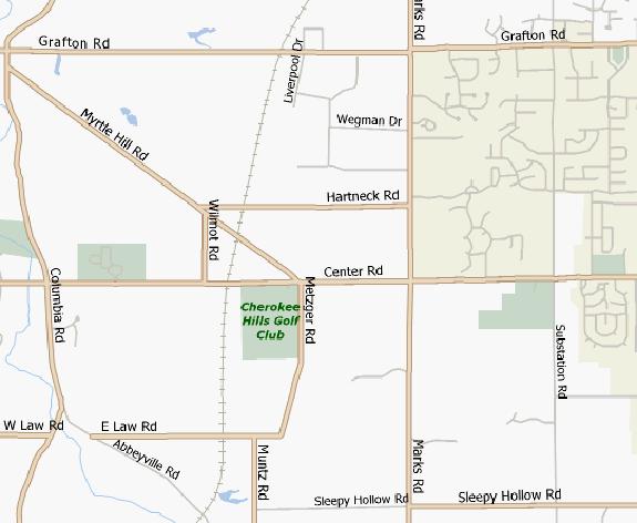
1 Planning Commission Final Plat Liverpool Fields, Phase 3 Liverpool Township App. No PP Meeting: August 6, 21 Applicant: Pride One Liverpool, LLC Owner: Pride One Liverpool, LLC Engineer: TGC Engineering Area: 19.9 acres Sublots: 2 Zoning: M Limited Manufacturing & Research Utilities: Central water and sanitary sewer School Dist.: Buckeye Local Reviewer: Rob Henwood EXECUTIVE SUMMARY The site is located on the northwest corner of the intersection of Marks and Center Roads (SR 33) (see location map). The applicant proposes to create two sublots on this 19.9 acre property, one will contain 9 rental units and will have access to 2.9 acres of open space and the other will be used as a 9.6 acre commercial site. The site is to be served by central water and sewer. Recommendation: APPROVAL WITH MODIFICATIONS Proposal: The applicant proposes to create two sublots; the first will contain 9 rental units and will have access to 2.9 acres of open space and the second will be used as a 9.6 acre commercial site. A retention basin is proposed on the southern portion of the residential site nearest SR 33. The site is to be served by central water and sewer. Access: Access to the site is provided by a private street which access Marks Road to the east. Secondary access to the site is provided by a through street connection to the north in Liverpool Fields Phases One and Two. Zoning: The subject property is zoned M Limited Manufacturing & Research. The property is the subject of a court settlement which permits multi-family residential uses on the property. The proposed lots are in conformance with the settlement. Background: A previous subdivision application, Glenbrooke Crossing, was approved for this site by the Planning Commission in May of 2; that approval expired in May of 21. Agency Comments: Italicized text indicates quotations from submitting agency comments. Ohio Dept. of Transportation, Dawn Roxberry, 7/3, 21. We do not have any comments since Phase 3 will directly access Marks Road and open space is shown for the frontage of SR
2 Liverpool Fields Phase 3, Final Plat 33, which is acceptable. When the commercial lot at the corner of Marks Road and SR 33 is developed in the future, we will determine whether a traffic impact study is needed at that time based on the development proposed. Highway Engineer, Andy Conrad, 7/2/21. CONDITIONAL APPROVAL 1. Area table does not match the Preliminary Plan. 2. Plat shows the same areas labelled as sublots and blocks. 3. Show and describe monument found at township lot corner at centerline of SR 33. Sanitary Engineer, Amy S. Lyon-Galvin, 7/2/21. Our office has no objections to the Final Plat. The lot lines and dimensions don't match the latest set of Phase 3 plans that Highway Engineer has, but I'm told they were preliminary. Only the first length of gravity sanitary sewer looks to be proposed as a public sewer within and easement to the ROW. The plans include one more length of private sanitary sewer followed by a force main with pump stations proposed for the buildings. The water looks to be private too, as they've positioned a master meter vault just outside the R/W to serve the development. As per our normal response, they'll still need to submit final plans and ultimately construct improvements that conform to the MCSE Rules and Regs. Liverpool Township, Dave Boettner, 7/11/21. Liverpool Township Trustees and Zoning recommend approval as proposed. Columbia Gas, Russ Johnson, 7/1/21. No facilities. Soil and Water Conservation District, Jim Dieter, 7/9/21 Proposed detention pond is part of the open space, the township will need to address the use of a detention pond as part of the open space requirement. A minimum of 15 foot buffer is recommended around the outside of the detention pond to perform any maintenance. The soil in the area is Mahoning silt loam and Ellsworth silt loam. Both soils have seasonal high water and are moderately slow permeability. Houses with basement may have limitations due to seasonal wetness. Aerial photographs indicate this field has been systematically tiled to help drainage for farm production. The tile should be routed around the constructed area and outlet at the stream. Broken tile may cause wet areas in construction areas. A 25 foot set back from the stream should be maintained as a riparian treed buffer. Tax Maps, Beth Mika, 7// We will need legal descriptions and a basic land survey drawing to split the property to a 1.3 acre parcel and a 9.6 acre parcel. The 9.6 acre parcel will require planning and township approval. 2. It appears, from the previous phases, that the only other involvement that the Tax Map Department will have is assigning addresses. We will need to know the number of units that will require a unique address. Health Department, Steve Mazak, 7/2/21. No comments. Medina Co. Planning Commission Page 2 of August 6, 21
3 Liverpool Fields Phase 3, Final Plat Staff Comments: 1. The following review assumes the Medina County Planning Commission (MCPC) approves the submitted Preliminary Plan for this subdivision at its August 6, 21 meeting. 2. The following required data/information was not provided on or with the Final Plat (Subdivision Regulations section references are included): a. Conditions from Preliminary Plan approval must be met before filing the Final Plat. (D)(2) Demonstrate all conditions of Preliminary Plan approval have been satisfied. b. The required building setback lines accurately shown with dimensions. (D)(2)f.. Show setback lines. c. Right-of-way width of each street within proposed subdivision and those adjoining must be shown. (D)(2)f.9. Label the streets as private and indicate the pavement width. d. Sublot and block identification - Sublots shall be numbered in consecutive order and blocks in alphabetical order. (D)(2)f.1. Label sublots and blocks as stated above. e. Total site data - Including acreage, number of residential lots, acres in parks, open space and other public uses, [and] acres in blocks. (D)(2)f.13. Show area in sublots and blocks. Label intended use of blocks; i.e. Open Space or Future Development. f. Signature and seal of a Registered Surveyor on each sheet. (D)(2)f.16. Add surveyors signature and seal on each sheet. g. Notarized certification by the owner or owners of the subdivision. (D)(2)f.17. Provide notarized certification by the owner/s. h. Certification from the Township that the Final Plat as submitted is in compliance with local zoning standards and requirements. Such Certification shall be in the form of an executed signature block on the original mylar and signed by at least two of the Township Trustees. (D)(2)g.1. Provide signatures from at least two of the Township Trustees. i. A subdivision served by a public central sanitary sewer shall be certified by the Medina County Sanitary Engineer. (D)(2)g.. Provide the signature of the Sanitary Engineer. j. Certification of County Engineer that all required improvements have been satisfactorily installed or financial guarantees have been provided to cover all construction ((D)(2)g.5) [and c]onstruction plans have been approved. ((D)(2)g.). Provide the signature of the County Engineer and add language indicating construction plans have been approved. k. Acceptance of offers of dedication by County Commissioners. (D)(2)g.6. Provide the signatures of the County Commissioners. 3. Sublots and blocks must be shown clearly. The residential area and the commercial lot shall be shown as Sublots 1 and 2. The open space area containing 2.9 acres must be delineated and labelled as Open Space Block A.. Drive labels must be changed to private street labels (see comment above). 5. The Street E connection to Liverpool Fields Phases 1 and 2 shall be included within the subdivision boundary or provisions must be made to modify the existing Phase 2 to include the construction of the street to the property boundary. Construction of Street E must be completed both inside and outside of the subdivision concurrently. Medina Co. Planning Commission Page 3 of August 6, 21
4 Liverpool Fields Phase 3, Final Plat 6. In total, the Liverpool Fields project (Phases 1 through 3) contains 155 dwelling units. Future additions to the project increasing the number of dwelling units may warrant an additional means of access and egress per Subdivision Regulation section 6(C)(3). 7. The proposed Final Plat fulfills the purpose and intent of the Subdivision Regulations and substantially meets the standards and requirements.. The proposed Final Plat is in substantial conformity with the approved Preliminary Plan and conditions of approval. Outstanding Planning Commission approval conditions for the Preliminary Plan must be satisfied prior to the Director signing the Final Plat. 9. The Final Plat appears to be in conformity with the court settlement governing the applicable zoning for this particular property. 1. The Medina County Sanitary Engineer HAS NOT determined that all required central wastewater disposal facilities and central water facilities have been satisfactorily installed or adequate financial guarantees have been approved. 11. The Medina County Highway Engineer HAS NOT approved the construction drawings. Upon approval of the construction drawings, the Director of Planning Services is authorized to execute the Final Plat on behalf of the Planning Commission upon certification by the Highway Engineer that the construction is complete or that adequate financial guarantees have been provided. Recommendation: Staff recommends the MCPC APPROVE WITH MODIFICATIONS the Liverpool Fields Phase 3 Final Plat. The applicant must submit the following corrections or additions prior to the Director signing the Final Plat: 1. Provide the following required data/information on or with the Final Plat: a. Demonstrate all conditions of Preliminary Plan approval have been satisfied. b. Show setback lines. c. Label the streets as private and indicate the pavement width. Remove references to drives. d. Label sublots and blocks as stated above. e. Show area in sublots and blocks. Label intended use of blocks; i.e. Open Space or Future Development. f. Add survey s signature and seal on each sheet. g. Provide all required signatures per comments above. h. Add language to the County Engineer s certification statement indicating construction plans have been approved. 2. Satisfy Highway Engineer s comments above. 3. Satisfy the Sanitary Engineer s comments above.. Satisfy the Tax Map comments above. 5. Label Sublots 1 and 2 per Staff Comment 3 above. The open space area must be labelled as Open Space Block A. 6. Drive labels must be replaced with private street labels. 7. The Street E connection to Liverpool Fields Phases 1 and 2 shall be included within the subdivision boundary or provisions must be made to modify the existing Phase 2 to include the construction of the street to the property boundary. Construction of Street E must be completed both inside and outside of the subdivision concurrently. R:\arcview\wp_planning\major_subdivisions\21\liverpool_fields_ph3\liverpool_fields_ph3_preplan\liverpool_fields_ph3_preplan_721.docx Medina Co. Planning Commission Page of August 6, 21
5 Liverpool Fields, Ph. 3 Pre. Plan & Final Plat App. 5 & Liverpool Township ROAD CENTER 1 99 Meeting Date: /6/21 Zoning: M Ltd. Man. & Res. Area: 19.9 acres Sublot/s: Visit us on the web at Brunswick Hills Twp MARKS ROAD inch = 25 feet Feet
6
7
Final Plat Trails at Redwood Falls, Ph. 1 Hinckley Township EXECUTIVE SUMMARY
 Final Plat Trails at Redwood Falls, Ph. 1 Hinckley Township Meeting: December 5, 2018 App. No.: 069-2017-PP Owner: Skyland Land Company LLC Engineer: TGC Engineering, T. Crane Parcel Nos.: 016-03A-38-012,
Commission Planning Final Plat Ledges of Stone Creek Hinckley Township EXECUTIVE SUMMARY
 Commission Planning Final Plat Ledges of Stone Creek Hinckley Township Meeting: February 1, 2017 App. No.: 127-2016-FP Applicant: Legacy-Carrington Dev. Group Engineer: TGC Engineering, LLC Parcel: 016-03A-39-003
Planning Commission Replat Falcon Pointe at Lake Medina Reserve, Ph. 3 Medina Township
 Planning Commission Replat Falcon Pointe at Lake Medina Reserve, Ph. 3 Medina Township Meeting: December 7, 2016 App. No.: 115-2016-R Applicant: W.J. Bailey Homes Owner: Crossbow Development Inc. Engineer:
EXECUTIVE SUMMARY. Access: Access to the site is by the proposed extension of Stockbridge Drive.
 Variance & Final Plat Preserve at Trillium Creek, Ph. 1 Montville Township Meeting: January 2, 2019 App. No.: 096-2018-FP Applicant: Haslinger Holdings Owners: Trillium Creek LLC Engineer: Lewis Land Prof.
Planning Commission Replat Arbor Lakes at Cobblestone Park, Ph. 10 Montville Township
 Planning Commission Replat Arbor Lakes at Cobblestone Park, Ph. 10 Montville Township Meeting: May 4, 2016 App. No.: 037-2016-R Developer: Cobblestone Park Development Group, LLC Surveyor: TGC Engineering
Planning Commission Preliminary Plan LRC Subdivision Montville Township
 Planning Commission Preliminary Plan LRC Subdivision Montville Township Meeting: February 1, 2017 App. No.: 002-2017-PP Owner: Faith & Hope Land Dev. Co. Applicant: Montville Investors LLC Engineer: Weber
Planning Commission Preliminary Plan Riverview Villas of Stonegate Medina Township App. No PP EXECUTIVE SUMMARY
 Planning Commission Preliminary Plan Riverview Villas of Stonegate Medina Township App. No. 088-2013-PP Meeting: January 8, 2014 Applicant: Stonegate Center, LLC Ken Cleveland Engineer: Lewis Land Professionals,
Planning Commission Final Plat Riverview Villas of Stonegate Medina Township App. No FP EXECUTIVE SUMMARY
 Planning Commission Final Plat Riverview Villas of Stonegate Medina Township App. No. 077-2014-FP Meeting: October 1, 2014 Applicant: Stonegate Center, LLC Ken Cleveland Engineer: Lewis Land Professionals,
Planning Commission Preliminary Plan Hidden Lakes Estates Medina Township EXECUTIVE SUMMARY
 Planning Commission Preliminary Plan Hidden Lakes Estates Medina Township Meeting: January 2, 2019 App. No.: 105-2018-PP Applicant: Hidden Lake Medina, LLC Engineer: Cunningham & Associates, LLC Parcel
EXECUTIVE SUMMARY. Block A9, acres Cobblestone Park PND
 Planning Commission Replat Arbor Lakes at Cobblestone Park Subdivision, Phase 9 Montville Township App. No. 04-2015-R Meeting: February 4, 2015 Developer: Cobblestone Park Development Group, LLC Surveyor:
Planning Commission Revised Preliminary Plan & Final Plat Maplebrooke Reserve Subdivision Montville Township EXECUTIVE SUMMARY
 Planning Commission Revised Preliminary Plan & Final Plat Maplebrooke Reserve Subdivision Montville Township Meeting: October 5, 2016 App. No.: 091-2016 RPP and 093-2016-FP Applicant: Cambridge Service
Variances & Preliminary Plan Hawks Ridge Montville Township EXECUTIVE SUMMARY
 Variances & Preliminary Plan Hawks Ridge Montville Township Meeting: February 6, 2019 App. No.: 002-2019-PP Applicant: Pulte Group Owners: Crum Family Ltd., RTE Investments LLC, Thomas Kowal Trustee Engineer:
Lake County Planning, Building and Development Department
 SUBMISSION CHECKLIST FOR SUBDIVISION FINAL PLAT Lake County Planning, Building and Development Department 500 W. Winchester Rd. Unit 101 Libertyville, Illinois 60048-1331 Telephone (847) 377-2600 E-mail:
Oakland County Michigan Register of Deeds Plat Engineering, GIS, & Remonumentation Dept. Ph: (248) Fax (248)
 Fax (248)") Oakland County Michigan Register of Deeds Plat Engineering, GIS, & Remonumentation Dept. Ph: (248)-858-1447 Fax (248)-858-7466 Requirements Needed for Final Plat Approval No. General Requirements. 1 Routing
Oakland County Michigan Register of Deeds Plat Engineering, GIS, & Remonumentation Dept. Ph: (248)-858-1447 Fax (248)-858-7466 Requirements Needed for Final Plat Approval No. General Requirements. 1 Routing
Minor Subdivision Application
 FOR PLANNING USE ONLY Application # SD Application Fee $1,000.00 Receipt No. Filing Date Completeness Date Minor Subdivision Application A. PROJECT INFORMATION 1. Project Name: 2. Address of Subject Property:
Township of Collier 2418 Hilltop Road Presto, PA 15142
 Township of Collier 2418 Hilltop Road Presto, PA 15142 Fees: Major: 2 checks $600 + $50 per lot & $1700 Escrow) APPLICATION FOR SUBDIVISION major FINAL only Plans must be folded Rolled plans will not be
MCGOWIN PARK EAST OF SATCHEL PAIGE SUBDIVISION, RESUBDIVISION OF
 # 14 SUB2015-00058 MCGOWIN PARK EAST OF SATCHEL PAIGE SUBDIVISION, RESUBDIVISION OF Engineering Comments: The following comments should be addressed prior to submitting the FINAL PLAT for acceptance and
Final Plat Mapping Requirements
 CURRENT PLANNING DIVISION 410 E. 5 th Street Loveland, CO 80537 970-962-2523 eplan-planning@cityofloveland.org cityofloveland.org/dc Final Plat Mapping Requirements All Final plats shall comply with the
SUBDIVISION APPLICATION CHECKLIST SKETCH PLAN PRELIMINARY PLAT FINAL PLAT
 RECEIVED STAMP SUBDIVISION APPLICATION CHECKLIST SKETCH PLAN PRELIMINARY PLAT FINAL PLAT A checklist of background information and submission requirements for processing of a sketch plan, preliminary plat
NOT TO BE SUBMITTED WITH SKETCH DESIGN APPROVAL Subdivision Checklist: Major Subdivision Final Plat
 Must be received with review fee (equal to $200.00, plus $25.00 per lot) no later than 15 days prior to Planning Board meeting, which is normally the first Monday of the month (certain holidays may modify
I. Requirements for All Applications. C D W
 108-16.1. Application checklists. Checklist for Required Submissions to the Planning Board or Zoning Board of Adjustment of Monroe Township All required submissions are to be made to the Administrative
Residential Major Subdivision Review Checklist
 Residential Major Subdivision Review Checklist Plan Submittal Requirements: 2 full sets of stamped plans Electric submittal - all plans contained in a single PDF 3 full sets if commercial kitchen or dining
To provide for the review of the final engineering plans, the subdivision improvement agreement, public dedications, and other legal agreements.
 ARTICLE 5 FINAL PLAT 501 Intent DOUGLAS COUNTY SUBDIVISION RESOLUTION To provide for the review of the final engineering plans, the subdivision improvement agreement, public dedications, and other legal
PRELMINARY PLAT CHECKLIST
 PRELMINARY PLAT CHECKLIST A. All preliminary plat submitted for approval shall be prepared by a Registered Professional Land Surveyor. B. Preliminary plats must be drawn to a scale of XXX with such accuracy
SECTION 6 - APPROVAL OF PLATS. Whenever any subdivision of land is proposed, and before any permit for the
 SECTION 6 - APPROVAL OF PLATS 6-1 APPROVAL REQUIRED BEFORE SALE Whenever any subdivision of land is proposed, and before any permit for the erection of a structure shall be granted, the subdivider or his
Preliminary Subdivision Application (Minor) (Three (3) lots or less)
 (Three (3) lots or less)") Gunnison City Offices www.gunnisoncity.org 38 West Center Gunnison, Utah 84634 (435) 528 7969 Date of Application: Preliminary Subdivision Application (Minor) (Three (3) lots or less) APPLICANT INFORMATION
Gunnison City Offices www.gunnisoncity.org 38 West Center Gunnison, Utah 84634 (435) 528 7969 Date of Application: Preliminary Subdivision Application (Minor) (Three (3) lots or less) APPLICANT INFORMATION
Preliminary Subdivision Application (Major) (Four (4) lots or more)
 (Four (4) lots or more)") Gunnison City Offices www.gunnisoncity.org 38 West Center Gunnison, Utah 84634 (435) 528 7969 Date of Application: Preliminary Subdivision Application (Major) (Four (4) lots or more) APPLICANT INFORMATION
Gunnison City Offices www.gunnisoncity.org 38 West Center Gunnison, Utah 84634 (435) 528 7969 Date of Application: Preliminary Subdivision Application (Major) (Four (4) lots or more) APPLICANT INFORMATION
CONDOMINIUM REGULATIONS
 ARTICLE 37 CONDOMINIUM REGULATIONS SECTION 37.01. Purpose The purpose of this Article is to regulate projects that divide real property under a contractual arrangement known as a condominium. New and conversion
REGULAR FINAL PLAT SUBDIVISION APPLICATION
 REGULAR FINAL PLAT SUBDIVISION APPLICATION Name of Subdivision (Subdivision Name must be approved by at 856-6216) ( )Cluster Subdivision ( )Lot-by-Lot Subdivision ( )Open Space Subdivision Name of Subdivision
BRIDGETON SUBDIVISION APPLICATION CHECKLIST
 APPLICATION NAME AND # CHECKLIST COMPLETED BY: DATE: Signature and printed name BRIDGETON SUBDIVISION APPLICATION CHECKLIST TO SUBDIVISION APPLICANTS: The attached checklist is to assist you in the submission
INSTRUCTIONS FINAL PLAT APPROVAL APPLICATION
 INSTRUCTIONS FINAL PLAT APPROVAL APPLICATION 1. The applicant/agent shall fill out the attached application. The attached application form must be completely filled in before it can be filed. Portions
City of Fort Lupton Amended Plat Process
 City of Fort Lupton Amended Plat Process Purpose The Amended Plat process is an administrative process to amend a recorded Plat. An Amended Subdivision is an administrative revision to a recorded Subdivision
Residential Minor Subdivision Review Checklist
 Residential Minor Subdivision Review Checklist Plan Submittal Requirements: 2 full sets of stamped plans Electric submittal - all plans contained in a single PDF 3 full sets if commercial kitchen or dining
APPLICATION REVIEW CHECKLISTS
 APPLICATION REVIEW CHECKLISTS The following must be submitted with and are part of each application. No application is complete until all required documentation has been submitted to the Community Development
WESTON COUNTY FINAL PLAT APPLICATION
 WESTON COUNTY FINAL PLAT APPLICATION Property Owner: Mailing Address of owner: Telephone Number(s) of owner: Property Owner: Mailing Address of owner: Telephone Number(s) of owner: (If subdivider/applicant
MINOR SUBDIVISION PLAT CHECKLIST
 MINOR SUBDIVISION PLAT CHECKLIST Project Name: Tax ID #: Project Number: Date: _ Reviewed By: Telephone: NOTES: All lots on septic systems must comply with the Fulton County Health Department requirements
TOWNSHIP OF BORDENTOWN LAND DEVELOPMENT APPLICATION CHECKLIST. General Requirements for all Applications
 TOWNSHIP OF BORDENTOWN LAND DEVELOPMENT APPLICATION CHECKLIST This CHECKLIST has been adopted in accordance with Section 25:807 of the Land Development Ordinance of the Township of Bordentown and will
ARTICLE 900 PLAT AND PLAN REQUIREMENTS
 ARTICLE 900 PLAT AND PLAN REQUIREMENTS SEC. 900.1 ITEMS TO BE SHOWN ON PLAT OR PLAN General (1) Property lines of all property owners adjacent to the exterior boundaries of the project shall be located
DAUPHIN CREEK ESTATES SUBDIVISION
 # 12 SUB-000076-2017 DAUPHIN CREEK ESTATES SUBDIVISION Engineering Comments: FINAL PLAT COMMENTS (should be addressed prior to submitting the FINAL PLAT for review and/or signature by the City Engineer):
Division of Land Application
 FOR PLANNING USE ONLY Application # DIV Application Fee Receipt No. Filing Date Completeness Date Division of Land Application A. PROJECT INFORMATION 1. Project Name: 2. Address of Subject Property: 3.
FINAL SUBDIVISION AND LAND DEVELOPMENT PLAN CHECKLIST. Plan Name. Applicant's Name:
 TOWNSHIP OF UPPER ST. CLAIR FINAL SUBDIVISION AND LAND DEVELOPMENT PLAN CHECKLIST Date Filed Plan Name PLC Applicant's Name: Phone Filing Date for Final Application Final Plat 114.22. FINAL APPLICATION
MASTER SUBDIVISION FINAL PLAT APPLICATION Town of Apex, North Carolina
 MASTER SUBDIVISION FINAL PLAT APPLICATION Town of Apex, North Carolina This document is a public record under the North Carolina Public Records Act and may be published to the Town s website or disclosed
TOWN OF ROXBURY PLANNING BOARD
 UPDATED: APRIL 2011 TOWN OF ROXBURY PLANNING BOARD Applicant s Guide for Subdivision Review The Town Planning Board administers the subdivision review process. This guide has been prepared in order to
MINOR SUBDIVISION FINAL PLAT APPLICATION Town of Apex, North Carolina
 MINOR SUBDIVISION FINAL PLAT APPLICATION Town of Apex, North Carolina This document is a public record under the North Carolina Public Records Act and may be published on the Town s website or disclosed
APPLICATION FOR MAJOR SUBDIVISION APPROVAL (FINAL PLAT)
") 209 S. Main Street Marysville, Ohio 43040 Phone: (937) 645-7350 Fax: (937) 645-7351 www.marysvilleohio.org APPLICATION FOR MAJOR SUBDIVISION APPROVAL (FINAL PLAT) *** IMPORTANT INFORMATION ~ Please read
209 S. Main Street Marysville, Ohio 43040 Phone: (937) 645-7350 Fax: (937) 645-7351 www.marysvilleohio.org APPLICATION FOR MAJOR SUBDIVISION APPROVAL (FINAL PLAT) *** IMPORTANT INFORMATION ~ Please read
FINAL PLAT CHECKLIST
 FINAL PLAT CHECKLIST Project Name: Tax ID #: Project Number: Date: _ Reviewed By: Telephone: Please address all items marked with an "X" Please return redline comments with corrected plan, original mylar,
PLYMOUTH PLANNING BOARD APPLICATION FOR A MINOR SUBDIVISION OR MAJOR SUBDIVISION
 CASE # PLYMOUTH PLANNING BOARD APPLICATION FOR A MINOR SUBDIVISION OR MAJOR SUBDIVISION The undersigned Applicant hereby submits to the Plymouth Planning Board a completed application for a proposed minor
2018 EASEMENT DEDICATION PACKET
 2018 EASEMENT DEDICATION PACKET (INCLUDES PARCELS OF LAND, EASEMENTS, AND RIGHTS-OF-WAY FOR PUBLIC USE) Information Packet There are various situations in which easements, rights-of-way, and parcels of
City of Colleyville Community Development Department. Subdivision Application Packet
 Community Development Department Subdivision Application Packet 1 Development Application Fees 100 Main Street Colleyville TX 76034 817.503.1050 Zoning Zoning Change $ 500 + $5 per acre Planned Unit Development
Application for Preliminary Plat Checklist
 Application for Preliminary Plat Checklist Note: No portion of an existing parcel may be sold or transferred to another party without first legally subdividing the property according to the City of Richmond
FILING INSTRUCTIONS FOR LOT LINE ADJUSTMENT APPLICATION
 Steve Weiss, AICP Planning Director FILING INSTRUCTIONS FOR LOT LINE ADJUSTMENT APPLICATION The following instructions are intended to provide the necessary information and procedures to facilitate the
STANDARDS GOVERNING CONVEYANCES OF REAL PROPERTY
 STANDARDS GOVERNING CONVEYANCES OF REAL PROPERTY Hancock County, Ohio Charity A. Rauschenberg, Hancock County Auditor Steven C. Wilson, Hancock County Engineer Revised: March 1, 2007 TRANSFER AND CONVEYANCE
Attached is a Clinton Township Zoning Permit Application and requirements for issuance of a permit.
 To Whom It May Concern: Attached is a Clinton Township Zoning Permit Application and requirements for issuance of a permit. The fee for the permit application is $75.00, which shall be made payable to
City of Prior Lake APPLICATION FOR REGISTERED LAND SURVEY
 Case File No. Property Identification No. City of Prior Lake APPLICATION FOR REGISTERED LAND SURVEY Requested Action Brief description of proposed project (Please describe the proposed amendment, project,
APPLICATION PROCEDURE
 ANTRIM PLANNING BOARD P. O. Box 517 Antrim, New Hampshire 03440 Phone: 603-588-6785 FAX: 603-588-2969 APPLICATION FORM AND CHECKLIST FOR MINOR OR MAJOR SITE PLAN REVIEW File Date Received By APPLICATION
Staff Report: Date: Applicant: Property Identification: Acreage of Request: Current Zoning of Requested Area: Requested Action: Attached:
 Staff Report: Completed by Jeff Palmer Director of Planning & Zoning Date: November 7, 2018, Updated November 20, 2018 Applicant: Greg Smith, Oberer Land Developer agent for Ronald Montgomery ET AL Property
The Filing Fee for a Minor Plat is $ PLUS $20.00 per lot created
 DEPARTMENT OF COMMUNITY DEVELOPMENT MINOR PLAT PROCEDURE The Filing Fee for a Minor Plat is $250.00 PLUS $20.00 per lot created Description: The purpose of a Minor Plat is to allow property to be platted
City of Prior Lake APPLICATION FOR COMBINED PRELIMINARY AND FINAL PLAT
 Case File No. Property Identification No. City of Prior Lake APPLICATION FOR COMBINED PRELIMINARY AND FINAL PLAT Requested Action Brief description of proposed project (Please describe the proposed amendment,
Gates County Planning and Zoning
 Gates County Planning and Zoning PO Box 411, 200 Court Street, Gatesville, NC 27938 phone: 252-357-2411 fax: 252-357-0073 Application for Technical Review Committee For Staff Use Only: Date: Application
City State Zip City State Zip. 1. Proposed Amendment Modifies Article or Section Numbers. 4. Describe the purpose of the proposed amendment
 APPLICATION FOR ZONING TEXT AMENDMENT (Subject to O.R.C. Section 519.12) Application # -ZC- Liberty Township Zoning Commission Date Filed: 2095 Reynoldsburg Baltimore Rd. NW Baltimore, OH 43105 Fee Paid:
LAND USE PERMIT APPLICATION
 LAND USE PERMIT APPLICATION Date Application No. TYPE OF PERMIT Subdivision Short Plat Conditional Use Binding Site Plan Final Plat Final Short Plat Variance Final Binding Site Plan Plat Amendment Short
MAJOR RESIDENTIAL AND NONRESIDENTIAL SUBDIVISIONS
 Lawrence-Douglas County MAJOR RESIDENTIAL AND NONRESIDENTIAL SUBDIVISIONS Preliminary Plats The applicant shall schedule a Pre-Application meeting with Planning Staff at least seven (7) working days prior
SUBMITTAL REQUIREMENTS: The number indicates the number of copies for submittal (if applicable).
.") Office Use Only Preliminary Long Plat Long Subdivision Applicant Checklist PLANNING, COMMUNITY, & ECONOMIC DEVELOPMENT DEPARTMENT PRELIMINARY LONG PLAT LONG SUBDIVISION CHECKLIST Mailing Address: P.O.
Office Use Only Preliminary Long Plat Long Subdivision Applicant Checklist PLANNING, COMMUNITY, & ECONOMIC DEVELOPMENT DEPARTMENT PRELIMINARY LONG PLAT LONG SUBDIVISION CHECKLIST Mailing Address: P.O.
géãç Éy VtÇtÇwt zât 5440 Routes 5 & 20 West Canandaigua, NY Phone: (585) / Fax: (585)
 / Fax: (585)") géãç Éy VtÇtÇwt zât 5440 Routes 5 & 20 West Canandaigua, NY 14424 Phone: (585) 394-1120 / Fax: (585) 394-9476 APPLICATION FOR LOT-LINE ADJUSTMENT The applicant is responsible for the completeness of all
géãç Éy VtÇtÇwt zât 5440 Routes 5 & 20 West Canandaigua, NY 14424 Phone: (585) 394-1120 / Fax: (585) 394-9476 APPLICATION FOR LOT-LINE ADJUSTMENT The applicant is responsible for the completeness of all
ARTICLE 900 PLAT AND PLAN REQUIREMENTS
 Final SEC. 900.01 ARTICLE 900 PLAT AND PLAN REQUIREMENTS General provisions. (a) Scale. The scale of all plats and plans shall be a minimum of 1 to 100 ft. (b) Size. The minimum page size for all plats
ARTICLE 9 SPECIFICATIONS FOR DOCUMENTS TO BE SUBMITTED
 ARTICLE 9 SPECIFICATIONS FOR DOCUMENTS TO BE SUBMITTED SECTION 950 GENERALLY All applications shall be properly signed and filed by the owner or, with the owner s specific written consent, a contract purchaser
Group Sewer Only** 80 Ft Frontage* 20,000 Sq. Ft. (.46 acre) Minimum** 120 Ft Frontage* 20,000 Sq. Ft. (.46acre) Minimum** 150 Ft Frontage*
 Minimum** 120 Ft Frontage* 20,000 Sq. Ft. (.46acre) Minimum** 150 Ft Frontage*") Residential Lots Minimum Chart The minimum lot size of any minor subdivision where there is no public sewers shall be as shown below or as required by township zoning and/or the Tuscarawas General Health
Residential Lots Minimum Chart The minimum lot size of any minor subdivision where there is no public sewers shall be as shown below or as required by township zoning and/or the Tuscarawas General Health
ARTICLE 4 MAJOR SUBDIVISION/LAND DEVELOPMENT PLAN REQUIREMENTS
 ARTICLE 4 MAJOR SUBDIVISION/LAND DEVELOPMENT PLAN REQUIREMENTS SECTION 401 LAND SKETCH PLANS FOR MAJOR SUBDIVISIONS AND DEVELOPMENTS 401.1 Sketch Plan Information The following process and procedures shall
Guide to Combined Preliminary and Final Plats
 Guide to Combined Preliminary and Final Plats Introduction The Douglas County is committed to providing open, transparent application processes to the public. This Guide is provided to assist anyone interested
DOUGLAS COUNTY SUBDIVISION RESOLUTION Article 4 Preliminary Plan 10/13/2015
 ARTICLE 4 PRELIMINARY PLAN 401 Intent An in-depth analysis of the proposed subdivision, including a review of the design considering the ability to obtain water and sanitation, identified geologic hazards,
ARTICLE 6 MINOR DEVELOPMENT FINAL PLAT Single-Family Residential
 ARTICLE 6 MINOR DEVELOPMENT FINAL PLAT Single-Family Residential 601 Intent The intent of the minor development is to provide a streamlined review process for the creation of ten or fewer single-family
Request for Action form is also defined as an application to be considered by the Planning Commission.
 CITY OF NORTH RIDGEVILLE INSTRUCTIONS FOR FILING REQUEST FOR ACTION APPLICATIONS WITH THE PLANNING COMMISSION (Please read the full instruction as it will help in providing a full complete application)
CITY OF FAYETTEVILLE, ARKANSAS FINAL PLAT FOR STAFF USE ONLY FINAL PLAT FEE: $ $ Date Application Submitted: Date Accepted as Complete:
 CITY OF FAYETTEVILLE, ARKANSAS FINAL PLAT FOR STAFF USE ONLY FINAL PLAT FEE: $200.00-$800.00 Date Application Submitted: Date Accepted as Complete: Project Number: Public Hearing S-T-R: PP#: Zone: Please
Plans shall be drawn at a readable scale, signed, and sealed by a Florida Registered Engineer. The application package shall include:
 CHAPTER 400. SECTION 403. PERMIT TYPES AND APPLICATIONS SITE DEVELOPMENT 403.3. Preliminary Site Plans (PSP) A. Intent and Purpose PSPs are used to identify existing site conditions and demonstrate general
Guide to Preliminary Plans
 Guide to Preliminary Plans Introduction The Douglas County is committed to providing open, transparent application processes to the public. This Guide is provided to assist anyone interested in the procedures
ARTICLE 5 MINOR SUBDIVISION/LAND DEVELOPMENT
 ARTICLE 5 MINOR SUBDIVISION/LAND DEVELOPMENT SECTION 501 ONLY FINAL PLAN REQUIRED The classification of a proposed subdivision as a "Minor Subdivision" shall only require the submission, review and approval
PLANNING BOARD CITY OF CONCORD, NH MINOR SUBDIVISION CHECKLIST
 PLANNING BOARD CITY OF CONCORD, NH MINOR SUBDIVISION CHECKLIST Summary This checklist is intended to assist applicants and design professionals in the preparation of minor subdivision applications for
LAND USE APPLICATION
 LAND USE APPLICATION File Name: File No(s).: Receipt No.: Receipt Date: Received By: Amount.: $ Instructions for Applicants Please read and follow all instructions on your application carefully. If you
SUBDIVISION & PLANNING APPROVAL STAFF REPORT Date: December 1, 2016
 SUBDIVISION & PLANNING APPROVAL STAFF REPORT Date: December 1, 2016 APPLICANT NAME SUBDIVISION NAME DEVELOPMENT NAME LOCATION Board of Water and Sewer Commissioners of the City of Mobile Halls Mill Road
Appendix A: Submittal Checklists
 Appendix A: Submittal Checklists A.1 Preliminary Plat Checklist A.2 Final Plat Checklist 11 Appendix A.1 DESIGN CHECKLIST FOR PRELIMINARY PLATS AND DEVELOPMENTS Development Name: Location: Date: Reviewed
City of Suwanee Development Regulations ARTICLE 10 PLAN AND PLAT SPECIFICATIONS
 ARTICLE 10 PLAN AND PLAT SPECIFICATIONS 10.1 CONCEPT PLAN SPECIFICATIONS The following paragraphs outline the required elements of both the required and optional plans and plats mentioned throughout these
DIVISION 2 - CONSTRUCTION PLAN AND MISCELLANEOUS REQUIREMENTS
 DIVISION 2 - CONSTRUCTION PLAN AND MISCELLANEOUS REQUIREMENTS 2.1 Required Plan Sheets 2.2 Drawing Requirements 2.3 Graphic Standards 2.4 Easements 2.5 Utility Locations 2.6 Private Facility Locations
1. Name of Property Owner Phone Address. 2. Name of Surveyor. Phone Address. 3. Lots, Block, Section. Subdivision
 MINOR LAND SUBDIVISION PLAN APPLICATION TO COMBINE ADJACENT LOTS WITHIN RECORDED SUBDIVISIONS COOLBAUGH TOWNSHIP 5550 MEMORIAL BOULEVARD TOBYHANNA, PA 18466 570-894-8490 ****************************************************************************************************
WESTMINSTER PARK PLACE SUBDIVISION
 WESTMINSTER PARK PLACE SUBDIVISION Engineering Comments: FINAL PLAT COMMENTS (should be addressed prior to submitting the FINAL PLAT for review and/or signature by the City Engineer): A. Provide all of
APPLICATION FOR MAJOR SUBDIVISION APPROVAL (PRELIMINARY PLAT)
") 209 S. Main Street Marysville, Ohio 43040 Phone: (937) 645-7350 Fax: (937) 645-7351 www.marysvilleohio.org APPLICATION FOR MAJOR SUBDIVISION APPROVAL (PRELIMINARY PLAT) *** IMPORTANT INFORMATION ~ Please
209 S. Main Street Marysville, Ohio 43040 Phone: (937) 645-7350 Fax: (937) 645-7351 www.marysvilleohio.org APPLICATION FOR MAJOR SUBDIVISION APPROVAL (PRELIMINARY PLAT) *** IMPORTANT INFORMATION ~ Please
SUBDIVISION APPLICATION: RECOMBINATION PLAT or EXEMPT PLAT
 SUBDIVISION APPLICATION: RECOMBINATION PLAT or EXEMPT PLAT Pursuant to Article 7, Section 155.706 of the Unified Development Code, an owner of land within the jurisdiction of the Town (or a duly authorized
MAJOR SUBDIVISION PRELIMINARY PLAT CHECKLIST
 TOWNSHIP OF EGG HARBOR PLANNING BOARD/ZONING BOARD OF ADJUSTMENT 3515 BARGAINTOWN ROAD EGG HARBOR TOWNSHIP, NJ 08234 MAJOR SUBDIVISION PRELIMINARY PLAT CHECKLIST The following checklist is designed to
City of Leavenworth DEPARTMENT OF DEVELOPMENT SERVICES MAJOR SUBDIVISION APPLICATION 1
 Proposed Name of Subdivision: City of Leavenworth DEPARTMENT OF DEVELOPMENT SERVICES MAJOR SUBDIVISION APPLICATION 1 FOR PRELIMINARY SUBDIVISION APPROVAL This application must be filled out legibly, in
APPENDIX B. SUBMISSION REQUIREMENTS
 Master Major Site Minor Site Landscape Section B.1 Table of /Plat Requirements Proposed or approved name of development, project, subdivision, and/or phase. Location, including township, county, and state.
COUNTY OF ALBEMARLE APPLICATION FOR RURAL SUBDIVISION
 Page 1 APPLICATION FOR RURAL SUBDIVISION The term rural subdivision means a type of subdivision that is located in the rural areas which results in two or more lots for the purpose of transfer of ownership
A. Appropriate agency responsible for transportation review for the subject property.
 7.8.10 Procedure Any person desiring to create a minor subdivision shall submit to the Commission for approval an application on forms provided by the Division, and a record plat in conformance with the
APPLICATION PACKET LAND SPLIT OR COMBINATION REVIEW
 APPLICATION PACKET LAND SPLIT OR COMBINATION REVIEW COMMUNITY DEVELOPMENT DEPARTMENT CHARTER TOWNSHIP OF PLYMOUTH 9955 N. Haggerty Road Plymouth, MI 48170 Fees Revised 9.13.2017 APPLICATION PACKET LAND
APPLICATION FOR PRELIMINARY PLAT CERRO GORDO COUNTY, IOWA
 APPLICATION FOR PRELIMINARY PLAT CERRO GORDO COUNTY, IOWA Before subdividing any tract of land and previous to the filing of an Application for conditional approval of the Preliminary Plat, the subdivider
McGowin Park, LLC. B-3, Community Business District
 # 10, 11, 12 SUB2014-00024 ZON2014-00500 ZON2014-00501 SUBDIVISION, PLANNED UNIT DEVELOPMENT (East), PLANNED UNIT DEVELOPMENT (West) STAFF REPORT Date: April 3, 2014 DEVELOPMENT NAME LOCATION McGowin Park,
SUBDIVISION APPLICATION
 SUBDIVISION APPLICATION Preliminary Plat Minor Plat Final Plat Amended Plat Applicant Name: Owner (if different from applicant) Name: Company: Company: Address: Address: City, State, Zip City, State, Zip
Staff Report: Date: Applicant: Property Identification: Acreage of Request: Current Zoning of Requested Area: Requested Action: Attached:
 Staff Report: Completed by Jeff Palmer Director of Planning & Zoning Date: November 7, 2018 Applicant: Greg Smith, Oberer Land Developer agent for Ronald Montgomery ET AL Property Identification: Frontage
SUBDIVISION APPLICATION INSTRUCTIONS
 SUBDIVISION APPLICATION INSTRUCTIONS APPLICATION FORM The application form must be fully completed, signed by the property owner and shall be properly notarized. AGENT AUTHORIZATION FORM If the applicant
CITY OF OCOEE LAND DEVELOPMENT CODE SUFFICIENCY TABLE WITH NOTES
 CITY OF OCOEE LAND DEVELOPMENT CODE SUFFICIENCY TABLE WITH NOTES The Sufficiency Table is a checklist to help identify the types of information and documentation needed for various types of projects. The
CHECKLIST FOR DEVELOPMENT REVIEW
 CHECKLIST FOR DEVELOPMENT REVIEW Petitions and related documents and plans for land development or other proposals regulated by Title 16 of the Municipal Code (Development Ordinance) and Title 17 of the
ARTICLE 13 CONDOMINIUM REGULATIONS
 ARTICLE 13 CONDOMINIUM REGULATIONS Section 13.01 Purpose. The purpose of this Article is to regulate projects that divide real property under a contractual arrangement known as a condominium. New and conversion