City of Yelm. Community Development Department BOUNDARY LINE ADJUSTMENT OR LARGE LOT SUBDIVISION
|
|
|
- Joel Price
- 5 years ago
- Views:
Transcription

1 City of Yelm Community Development Department BOUNDARY LINE ADJUSTMENT OR LARGE LOT SUBDIVISION Fee Date Received By File No. FEES: Boundary Line Adjustment $ LARGE LOT SUBDIVISION $250.00, + $10.00/lot (In addition, any professional service charges per Resolution #358) PLEASE SUBMIT CURRENT PLAT CERTIFICATE WITH APPLICATION (Limited Liability Title Report) Boundary Line Adjustment Large Lot Subdivision NOTE: ALL CURRENT, ADVANCE, AND DELINQUENT TAXES MUST BE PAID PRIOR TO APPROVAL. (ASSESSOR CAN PROCESS A SEGREGATION FOR PROPERTY ASSESSMENT PURPOSES.) NAME OF PROJECT Owner of Parcel(s) Purchaser of Parcel(s) Representative APPLICANT Mailing Address City, State and Zip Telephone OWNER Mailing Address City, State and Zip Telephone SURVEYOR Mailing Address City, State and Zip Telephone PROPERTY DESCRIPTION General Location Address of Site (if assigned) Area of Project (in acres, if possible) Area of entire contiguous ownership (if other than above) Section Township Range Assessor s Tax Parcel Number(s) of property included in this application: Zoning District Shoreline Designation (if applicable) Comprehensive Plan/Sub-Area Plan Designation Type of on-site structures (give lot numbers) (SHOW LOCATION AND LABEL EACH STRUCTURE ON MAP) 105 Yelm Avenue West (360) Yelm, WA (360) FAX
2 WHAT USES ARE PROPOSED FOR THE VACANT LOTS? The uses must be consistent with zoning. Single Family, on Lots Duplex, on Lots Multifamily, on Lots Commercial, on Lots Industrial, on Lots IF UNDECIDED, LOTS WILL BE REVIEWED FOR ONE SINGLE-FAMILY RESIDENCE PER LOT. Existing sewage disposal: None Septic tank (date installed ) Sewer (SHOW ON MAP) Proposed sewage disposal: None Septic tank Sewer Other Existing water supply: None Individual well on lot(s) # (SHOW ON MAP) Community Well -- Name of System or Owner Municipal Water System -- Name of Municipality Proposed water supply: None Individual Wells Community Well -- Name of System or Owner Municipal Water System -- Name of Municipality Special areas on your project site: (Show checked areas on map) Creek or Stream River (Name) Lake/Pond (Name) Cliffs Draw/Gully None (Name) Swamp/Bog Has a portion of your project site ever flooded? No Do not know Yes, when? (If yes, show area on map) BOUNDARY LINE ADJUSTMENTS ONLY Lot #, Lot Area in Square Feet Lot #, Lot Area in Square Feet Lot #, Lot Area in Square Feet Lot #, Lot Area in Square Feet Does the property being subdivided have city/county/state road frontage? No Yes City of County State If yes, name of road Right-of-Way width of road frontage If no, width and length of private road, easement or right-of-way: feet w by feet l If property to be divided is accessed by a private road, how many other parcels have access by this road? (Include vacant parcels.) (FOR YELM TOWNHOUSE SHORT PLATS ONLY) 1. For existing townhouse units being short platted: Do the common walls meet building and fire codes? Yes No 2. For proposed townhouse units: Has the applicant submitted the following to the Site Plan Review Committee? Yes No (If no, your short plat will be held pending the submittal of those items listed below.) A) Building Plans. Typical front and side elevations and exterior architectural treatments of the proposed units. B) Site Plans. Location of buildings in relation to property and lot lines, off-street parking areas, patio and service areas, including garbage disposal areas, landscaping, walls, fences, public and private streets, driveways, all common facilities, open space and walkways. In addition, lot size, percentage of ground coverage and open space shall be included as data on such plan. A topographic map shall also be submitted showing existing and proposed contours at two-foot intervals and which locates existing streams, lakes, marshes and other natural features. The requirement of the topographic map may be waived by the Site Plan Review Committee if it deems it not necessary. 105 Yelm Avenue West (360) Yelm, WA (360) FAX
3 PLAT MAP (Submit 8 folded blue-line prints) The plat datum, north arrow, date and scale at one inch equals either fifty feet, one hundred feet, two hundred feet, or, for large lot subdivisions only, four hundred feet. The boundary lines of the property to be adjusted. The boundaries of existing adjacent or internal lots, blocks and streets shown with dotted lines. The location and direction of all existing and proposed watercourses, lakes and streams and the location of all areas subject to flooding. The boundaries of any natural resource lands or critical areas as defined by the city. Existing and proposed uses of each lot, including location of all existing structures. Boundaries and proposed use of lands to be reserved for the common use of property owners within the subdivision or of other private organizations. Location of any wells and underground storage tanks within two hundred feet of the proposed subdivision. The location, size and elevation of all existing sewers, water mains, storm water facilities, culverts and other public or private underground installations and utilities within and adjacent to the subdivision, showing points of probable connection; and drawing for water supply stating the source and general distribution system layout; for sewage and wastewater collection and treatment; and for storm water collection, release, drainage and treatment. Location, widths and names of all existing and proposed streets, sidewalks, railroads, power lines, telephone lines within or adjacent to the proposed subdivision. The layout and dimensions of existing and proposed street and alley rights-ofway, utility and access easements and lots and blocks. The location of other significant features such as city limits, section lines and section corners. Existing and proposed survey and elevation monuments. MAIL LABELS (8 ½ X 11 sheet) Large Lot Subdivision ONLY Owners of Property within 300 feet (include Assessor s Tax Parcel Numbers and map). A REDUCED SIZE COPY of the site plan not larger than 11"X17". 105 Yelm Avenue West (360) Yelm, WA (360) FAX
4 DECLARATION OF BOUNDARY LINE ADJUSTMENT AND COVENANTS KNOW ALL MEN BY THESE PRESENTS: That we the undersigned having a real interest in the tract of land described by the declaration; and do hereby declare the herein described adjustment of land certified as Boundary Line Adjustment Number, on the day of, 20, by the Planning Department, subject to the following covenants and conditions: 1. That all subsequent deeds will contain provisions for private roads in the manner described herein. 2. That all maintenance of any private road described by this declaration shall be by the owners of the parcels having legal access therefrom or their heirs, assigns, or successors, unless and until such roads are improved to the subdivision standards and dedicated to and accepted by the appropriate governmental jurisdiction. 3. That any private road will be subject to the further right of the grantor or his successor and of any telephone, electric, gas, water, or sewer company, public or private, to lay or cause to be laid and the right of ingress or egress for the purpose of maintaining telephone, electric, gas, water or sewer pipes, mains, or conduits across a described portion of such road. 4. That with respect to any private road described by this declaration whether it remains private or becomes a dedicated road, there is the additional right to make all necessary slopes for cuts and fills; and the rights to continue to drain said roads and ways over and across any lot or lots where the water might take a natural course upon reasonable grading pursuant to improvement for dedication of the roads and ways shown herein. Following reasonable grading pursuant to improvement for dedication of the roads and ways shown herein, no drainage waters on any lot or lots shall be diverted or blocked from their natural course so as to discharge upon any public road rights-of-way or to hamper proper road drainage. 5. That the adjusted legal description of each of the tracts being adjusted is attached hereto and incorporated by reference as though fully set out herein. 6. That additional covenant, easements, restrictions, if any, solely for the benefit of the grantor, and his heirs, successors, and assigns enforceable only by such persons, are attached hereto either as exhibits or as previously recorded under Auditor s File Number and incorporated by reference as though fully set our herein. That these covenants are for the mutual benefit of the grantor and his heirs, successors and assigns and are for the further purpose of compliance with the resolutions and regulations of the appropriate local governmental jurisdiction, and the local government and such persons are specifically given the right to enforce these restrictions and reservations by injunction or other lawful procedure and to recover any damages resulting from such violation. DATED this day of, 20.
5 STATE OF WASHINGTON ) ) ss. COUNTY OF THURSTON ) On this day personally appeared before me to me known to be the individual described in and who executed the within and foregoing instrument, and acknowledged that signed the same as free and voluntary act and deed, for the uses and purposes therein mentioned. GIVEN under my hand and official seal this day of, 20. NOTARY PUBLIC in and for the State of Washington residing at STATE OF WASHINGTON ) ) ss. COUNTY OF THURSTON ) On this day personally appeared before me to me known to be the individual described in and who executed the within and foregoing instrument, and acknowledged that signed the same as free and voluntary act and deed, for the uses and purposes therein mentioned. GIVEN under my hand and official seal this day of, 20. NOTARY PUBLIC in and for the State of Washington residing at AUDITOR S CERTIFICATE File for record at the request of this day of, 20, at minutes past o clock.m., and recorded in Volume of Large Lot Subdivisions on page, records of Thurston County, Washington. Thurston County Auditor By: Deputy
6 LEGAL DESCRIPTION(S) OF PARCEL(S) I hereby certify that the above legal description(s) are accurate and in compliance with Subdivision Code. Said descriptions (are) (are not) based upon a Recorded Survey. Submitted this day of, 20. Name of Title Co. Or Surveyor Signature
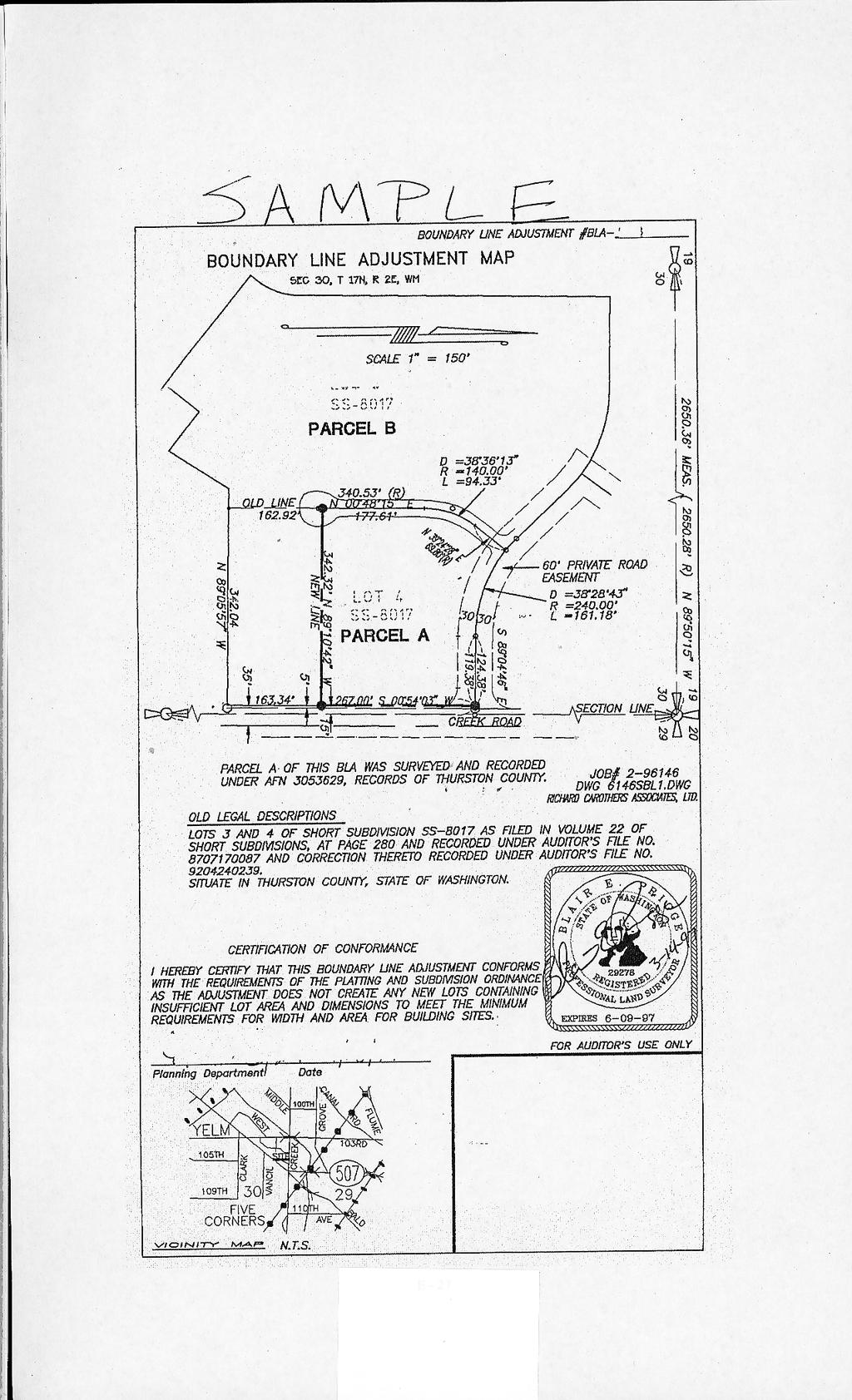
7 Boundary Line Adjustment BOUNDARY LINE ADJUSTMENT MAP CERTIFICATION OF CONFORMANCE DO NOT WRITE IN BOX FOR OFFICIAL USE I hereby certify that this boundary line adjustment conforms with the requirements of the Platting and Subdivision Ordinance as the adjustment does not create any new lots containing insufficient lot area and dimension to meet the minimum requirements for width and area for building sites. Planning Department
8
Boundary Line Adjustment / Lot Combination General Instructions and Submittal Forms
 CITY OF TENINO PO BOX 4019 149 Hodgden Street South Tenino, WA 98589-4019 Phone (360) 264-2368 FAX (360) 264-5772 Boundary Line Adjustment / Lot Combination General Instructions and Submittal Forms The
SUBMITTAL REQUIREMENTS: The number indicates the number of copies for submittal (if applicable).
.") Office Use Only Preliminary Long Plat Long Subdivision Applicant Checklist PLANNING, COMMUNITY, & ECONOMIC DEVELOPMENT DEPARTMENT PRELIMINARY LONG PLAT LONG SUBDIVISION CHECKLIST Mailing Address: P.O.
Office Use Only Preliminary Long Plat Long Subdivision Applicant Checklist PLANNING, COMMUNITY, & ECONOMIC DEVELOPMENT DEPARTMENT PRELIMINARY LONG PLAT LONG SUBDIVISION CHECKLIST Mailing Address: P.O.
LABEL PLEASE NOTE: ALL APPLICATIONS AND SITE PLANS MUST BE COMPLETED IN BLACK OR BLUE INK ONLY Intake by:
 STAFF USE ONLY Thurston County Resource Stewardship 2000 Lakeridge Dr. S.W. Olympia, WA 98502 (360)786-5490 / (360)754-2939 (Fax) TDD Line (360) 754-2933 Email: permit@co.thurston.wa.us Supplemental Application
PRELIMINARY PLAT Checklist
 PRELIMINARY PLAT Checklist 3715 Bridgeport Way W University Place, WA 98466 PH: (253) 566-5656 FAX: (253) 460-2541 This is a checklist of materials required for a Preliminary Plat. This checklist is provided
Waseca County Planning and Zoning Office
 Waseca County Planning and Zoning Office 300 North State Street Waseca, Minnesota 56093 Phone: 507-835-0650 Fax: 507-837-5310 Form no. PZ 081009 Web Site: www.co.waseca.mn.us FEES: 1) CUP FEE- $400.00
SUBDIVISION APPLICATION
 SUBDIVISION APPLICATION Preliminary Plat Minor Plat Final Plat Amended Plat Applicant Name: Owner (if different from applicant) Name: Company: Company: Address: Address: City, State, Zip City, State, Zip
SUBMITTAL REQUIREMENTS: The number indicates the number of copies for submittal (if applicable).
.") Office Use Only Preliminary Long Plat Long Subdivision Applicant Checklist PLANNING, COMMUNITY, & ECONOMIC DEVELOPMENT DEPARTMENT FINAL LONG PLAT LONG SUBDIVISION CHECKLIST Mailing Address: P.O. Box 547,
Office Use Only Preliminary Long Plat Long Subdivision Applicant Checklist PLANNING, COMMUNITY, & ECONOMIC DEVELOPMENT DEPARTMENT FINAL LONG PLAT LONG SUBDIVISION CHECKLIST Mailing Address: P.O. Box 547,
SHORT PLAT Information
 Information This form provides information and an explanation of the procedures of a Short Plat. If you have any questions, contact the Planning and Development Services Department at (253) 566-5656. A
City of Leavenworth DEPARTMENT OF DEVELOPMENT SERVICES MAJOR SUBDIVISION APPLICATION 1
 Proposed Name of Subdivision: City of Leavenworth DEPARTMENT OF DEVELOPMENT SERVICES MAJOR SUBDIVISION APPLICATION 1 FOR PRELIMINARY SUBDIVISION APPROVAL This application must be filled out legibly, in
PLANNING & DEVELOPMENT SERVICES 1800 Continental Place Mount Vernon, WA Inspections Office Fax 360.
 PLANNING & DEVELOPMENT SERVICES 1800 Continental Place Mount Vernon, WA 98273 Inspections 360.416.1330 Office 360.416-1320 Fax 360.416-1340 Date Received: Administrative Setback Reduction Checklist Pursuant
PRELMINARY PLAT CHECKLIST
 PRELMINARY PLAT CHECKLIST A. All preliminary plat submitted for approval shall be prepared by a Registered Professional Land Surveyor. B. Preliminary plats must be drawn to a scale of XXX with such accuracy
ARTICLE 900 PLAT AND PLAN REQUIREMENTS
 ARTICLE 900 PLAT AND PLAN REQUIREMENTS SEC. 900.1 ITEMS TO BE SHOWN ON PLAT OR PLAN General (1) Property lines of all property owners adjacent to the exterior boundaries of the project shall be located
APPLICATION FOR PRELIMINARY PLAT CERRO GORDO COUNTY, IOWA
 APPLICATION FOR PRELIMINARY PLAT CERRO GORDO COUNTY, IOWA Before subdividing any tract of land and previous to the filing of an Application for conditional approval of the Preliminary Plat, the subdivider
CHECKLIST FOR DEVELOPMENT REVIEW
 CHECKLIST FOR DEVELOPMENT REVIEW Petitions and related documents and plans for land development or other proposals regulated by Title 16 of the Municipal Code (Development Ordinance) and Title 17 of the
TOWNSHIP OF BORDENTOWN LAND DEVELOPMENT APPLICATION CHECKLIST. General Requirements for all Applications
 TOWNSHIP OF BORDENTOWN LAND DEVELOPMENT APPLICATION CHECKLIST This CHECKLIST has been adopted in accordance with Section 25:807 of the Land Development Ordinance of the Township of Bordentown and will
BOUNDARY LINE ADJUSTMENT APPLICATION PACKET
 BOUNDARY LINE ADJUSTMENT APPLICATION PACKET City of Sedro-Woolley Building, Planning & Engineering 325 Metcalf Street, Sedro-Woolley, WA 98284 Phone 360-855-0771 Fax 360-855-0733 City of Sedro-Woolley
E L M E R B O R O U G H L A N D U S E B O A R D APPLICATION COVER SHEET (to be completed for all applications and appeals)
") E L M E R B O R O U G H L A N D U S E B O A R D APPLICATION COVER SHEET (to be completed for all applications and appeals) 1. Name(s): 2. Address: 3. Telephone Number(s): 4. E-mail: 5. Owner Name(s) (if
E L M E R B O R O U G H L A N D U S E B O A R D APPLICATION COVER SHEET (to be completed for all applications and appeals) 1. Name(s): 2. Address: 3. Telephone Number(s): 4. E-mail: 5. Owner Name(s) (if
SPECIAL SERVICE AREA DISCLOSURE
 SPECIAL SERVICE AREA DISCLOSURE All lots within this subdivision are included within the County of Will Special Service Area Number and are subject to an annual tax levy in accordance with the provisions
CITY OF SARALAND FINAL SUBDIVISION PLAT REVIEW
 CITY OF SARALAND FINAL SUBDIVISION PLAT REVIEW Application Number: Date Plat Submitted: Name of Subdivision: Name of Owner: Owner Address: (Street or P.O. Box) Telephone #: (City) (State) (Zip) E-mail:
Sketch Plan 2018 Bargersville Plan Commission Application Kit
 Sketch Plan 2018 Bargersville Plan Commission Application Kit For Commercial, Industrial, and Residential Developments At least 31 days prior to the intended filing of the Primary Plat or Development Plan
MAJOR SUBDIVISION PRELIMINARY PLAT CHECKLIST
 TOWNSHIP OF EGG HARBOR PLANNING BOARD/ZONING BOARD OF ADJUSTMENT 3515 BARGAINTOWN ROAD EGG HARBOR TOWNSHIP, NJ 08234 MAJOR SUBDIVISION PRELIMINARY PLAT CHECKLIST The following checklist is designed to
LAND USE PERMIT APPLICATION
 LAND USE PERMIT APPLICATION Date Application No. TYPE OF PERMIT Subdivision Short Plat Conditional Use Binding Site Plan Final Plat Final Short Plat Variance Final Binding Site Plan Plat Amendment Short
I. Requirements for All Applications. C D W
 108-16.1. Application checklists. Checklist for Required Submissions to the Planning Board or Zoning Board of Adjustment of Monroe Township All required submissions are to be made to the Administrative
Individual Well Individual Septic. Community Well 19. What is the proposed method of sewage disposal? Public. None
 Please Answer the Following Questions: (attach sheet if needed). What type of facility is being proposed? Campground Recreational Vehicle (RV) Park Both 2. What is the total acreage of the proposed facility?
Initial Subdivision Applications Shall Include the Following:
 Initial Subdivision Applications Shall Include the Following: 1) Subdivision Application Form: completely filled out (12 copies) 2) Plat: The Plat must adhere to the requirements set forth in the Town
FINAL PLAT APPLICATION
 FINAL PLAT APPLICATION (Page 1 of 3) LEGAL OWNER(s): NAME: STREET ADDRESS OWNER(s): CITY, STATE, ZIP CODE: PHONE NUMBER: BILLING ADDRESS: NAME OF ENGINEER/SURVEYOR: Engineer/Surveyor Address, Phone: PROPERTY
MINOR SUBDIVISION PLAT CHECKLIST
 MINOR SUBDIVISION PLAT CHECKLIST Project Name: Tax ID #: Project Number: Date: _ Reviewed By: Telephone: NOTES: All lots on septic systems must comply with the Fulton County Health Department requirements
SHORT SUBDIVISION. * We recommend that the application be filled out by or under the supervision of a registered land surveyor.
 615 W. Alder St. Bldg. 8, Shelton, Wa 98584 Phone: (360) 427-9670 ext. 352 Fax: (360) 427-7798 SHORT SUBDIVISION WHEN DO I NEED A SHORT SUBDIVISION APPLICATION? If you have a tract of land and you want
Chelan County Department of Community Development 316 Washington Street, Suite 301, Wenatchee, WA Telephone: (509) Fax: (509)
 Fax: (509)") Chelan County Department of Community Development 316 Washington Street, Suite 301, Wenatchee, WA 98801 Telephone: (509) 667-6225 Fax: (509) 667-6475 Boundary Line Adjustment Type or Print Legibly in Black
Chelan County Department of Community Development 316 Washington Street, Suite 301, Wenatchee, WA 98801 Telephone: (509) 667-6225 Fax: (509) 667-6475 Boundary Line Adjustment Type or Print Legibly in Black
Simple Land Division by Love and Affection - Application Checklist
 Simple Land Division by Love and Affection - Application Checklist Yes No A completed simple land division application form, with identification of property owner(s) for each lot. Fee per adopted fee schedule.
SUBDIVISION PLAT CHECKLIST. The following information shall be include on the plat:
 SUBDIVISION PLAT CHECKLIST Subdivision Name: Land Surveyor: Owner/Developer: Date Submitted: The following information shall be include on the plat: The plat shall be drawn at a scale of one inch equals
APPLICATION FOR PRELIMINARY PLAT RESIDENTAIL. FILING FEE: $ for the first 20 lots; $10.00 for each additional lot over 20
 COMMUNITY PLANNING & DEVELOPMENT TELEPHONE.* (816) 331-4331 FAX * (816) 331-6973 CITY HALL ANNEX 520 MAIN STREET BELTON, MISSOURI 64012 WEBSITE * www.belton.org APPLICATION FOR PRELIMINARY PLAT RESIDENTAIL
PLANNING BOARD CITY OF CONCORD, NH MINOR SUBDIVISION CHECKLIST
 PLANNING BOARD CITY OF CONCORD, NH MINOR SUBDIVISION CHECKLIST Summary This checklist is intended to assist applicants and design professionals in the preparation of minor subdivision applications for
APPLICATION PROCEDURE
 ANTRIM PLANNING BOARD P. O. Box 517 Antrim, New Hampshire 03440 Phone: 603-588-6785 FAX: 603-588-2969 APPLICATION FORM AND CHECKLIST FOR MINOR OR MAJOR SITE PLAN REVIEW File Date Received By APPLICATION
CITY OF SARALAND PRELIMINARY SUBDIVISION PLAT REVIEW
 PRELIMINARY SUBDIVISION PLAT REVIEW Application Number: Date Plat Submitted: Name of Subdivision: Name of Owner: Owner Address: (Street or P.O. Box) Telephone #: (City) (State) (Zip) E-mail: Name of Authorized
LAND SPLIT APPLICATION AND SUBMITTAL REQUIREMENTS
 LAND SPLIT APPLICATION AND SUBMITTAL REQUIREMENTS PARCELS 2.5> ACRES OR SMALLER: THIS APPLICATION IS REQUIRED TO DIVIDE LAND INTO TWO OR THREE PARCELS. PARCELS LARGER THAN 2.5 ACRES: THIS APPLICATION IS
LAND USE APPLICATION
 LAND USE APPLICATION File Name: File No(s).: Receipt No.: Receipt Date: Received By: Amount.: $ Instructions for Applicants Please read and follow all instructions on your application carefully. If you
ARTICLE 5 MINOR SUBDIVISION/LAND DEVELOPMENT
 ARTICLE 5 MINOR SUBDIVISION/LAND DEVELOPMENT SECTION 501 ONLY FINAL PLAN REQUIRED The classification of a proposed subdivision as a "Minor Subdivision" shall only require the submission, review and approval
SUBDIVISION APPLICATION
 STAFF USE ONLY Date Submitted: Received by: Fee paid: Project # REQUIRED SUBMITTALS Application Fee: $600.00 (up to 5 lots) + $50.00 (per lot above 5) Publication Fee: $300.00 Mailing Fee: $6.00 per hearing
SUBDIVISION APPLICATION
 SUBDIVISION APPLICATION City of Horn Lake Planning Department 3101 Goodman Road, W Horn Lake, MS 38637 662-342-3559 Fax: 662-342-3485 Applications due the 1st working day of the month. Submit application
MUDDY CREEK TOWNSHIP PO BOX 239 PORTERSVILLE, PA SUBDIVISION AND LAND DEVELOPMENT APPLICATION
 MUDDY CREEK TOWNSHIP PO BOX 239 PORTERSVILLE, PA 16051 724-368-3438 SUBDIVISION AND LAND DEVELOPMENT APPLICATION NOTE TO ALL APPLICANTS: This checklist must be completed in its entirety If an item is not
ARTICLE SINGLE FAMILY SITE CONDOMINIUM DEVELOPMENT STANDARDS
 ARTICLE 28.00 SINGLE FAMILY SITE CONDOMINIUM DEVELOPMENT STANDARDS Section 28.01 PURPOSE The purpose of this Article is to recognize that conventional single family developments, traditionally developed
INCOMPLETE APPLICATIONS WILL BE RETURNED! GENERAL PROPERTY INFORMATION. Applicant s name Day Phone address Authorized Agent (if applicable)
") Environmental Services Planning & Zoning 601 Third Avenue Two Harbors, MN 55616 www.co.lake.mn.us (218)834-8327 Fax: (218)-834-8365 LAKE COUNTY ADMINISTRATIVE SUBDIVISION APPLICATION PLEASE COMPLETE IN
Environmental Services Planning & Zoning 601 Third Avenue Two Harbors, MN 55616 www.co.lake.mn.us (218)834-8327 Fax: (218)-834-8365 LAKE COUNTY ADMINISTRATIVE SUBDIVISION APPLICATION PLEASE COMPLETE IN
Residential Major Subdivision Review Checklist
 Residential Major Subdivision Review Checklist Plan Submittal Requirements: 2 full sets of stamped plans Electric submittal - all plans contained in a single PDF 3 full sets if commercial kitchen or dining
DECLARATION OF RECIPROCAL ACCESS AND UTILITY EASEMENTS
 ITEM 175-2701-C0517 Page 1 of 6 Return to: Grant Road LLC 1430 Country Manor Boulevard, Suite 3 Billings, MT 59102 DECLARATION OF RECIPROCAL ACCESS AND UTILITY EASEMENTS This Reciprocal Easement Declaration
Tentative Map Application Review Procedures
 FOR REFERENCE ONLY This page is not part of the application. Tentative Map Application Review Procedures The tentative map process in Churchill County is designed to provide a mechanism in order to divide
MINOR PLAT FILING APPLICATION
 FILING APPLICATION Date of PC Meeting: Date of BCC Meeting: Fee Paid: 1. APPLICANT: DAYTIME PHONE: MAILING ADDRESS: LANDOWNER: DAYTIME PHONE: MAILING ADDRESS: AUTHORIZED AGENT: MAILING ADDRESS: RELATIONSHIP
ELMORE COUNTY LAND USE & BUILDING DEPARTMENT 520 E 2 nd South Mountain Home, ID (208) Preliminary Plat Application
 Preliminary Plat Application") ELMORE COUNTY LAND USE & BUILDING DEPARTMENT 520 E 2 nd South Mountain Home, ID 83647 (208) 587-2142 www.elmorecounty.org Preliminary Plat Application We are unable to accept facsimile copies. (Subdivisions
ELMORE COUNTY LAND USE & BUILDING DEPARTMENT 520 E 2 nd South Mountain Home, ID 83647 (208) 587-2142 www.elmorecounty.org Preliminary Plat Application We are unable to accept facsimile copies. (Subdivisions
Township of Little Egg Harbor Planning Board 665 Radio Road Little Egg Harbor, New Jersey Phone: ext. 221 Fax:
 BLOCK(S) LOT(S) Township of Little Egg Harbor Planning Board 665 Radio Road Little Egg Harbor, New Jersey 08087 Phone: 609-296-7241 ext. 221 Fax: 609-294-3040 Development Application Amended Development
Residential Minor Subdivision Review Checklist
 Residential Minor Subdivision Review Checklist Plan Submittal Requirements: 2 full sets of stamped plans Electric submittal - all plans contained in a single PDF 3 full sets if commercial kitchen or dining
A.3. ARTICLE 7 PLAN REQUIREMENTS FOR MINOR SUBDIVISION AND/OR LAND DEVELOPMENT
 700. 701.A.3. ARTICLE 7 PLAN REQUIREMENTS FOR MINOR SUBDIVISION AND/OR LAND DEVELOPMENT SECTION 700 PURPOSE The purpose of this Article is to set forth a streamlined set of Plan Requirements for minor
ARTICLE 900 PLAT AND PLAN REQUIREMENTS
 Final SEC. 900.01 ARTICLE 900 PLAT AND PLAN REQUIREMENTS General provisions. (a) Scale. The scale of all plats and plans shall be a minimum of 1 to 100 ft. (b) Size. The minimum page size for all plats
CHAPTER 3 PRELIMINARY PLAT
 10-3-1 10-3-3 SECTION: CHAPTER 3 PRELIMINARY PLAT 10-3-1: Consultation 10-3-2: Filing 10-3-3: Requirements 10-3-4: Approval 10-3-5: Time Limitation 10-3-6: Grading Limitation 10-3-1: CONSULTATION: Each
-MENDOCINO COUNTY PLANNING AND BUILDING SERVICES- DIVISION OF LAND REGULATIONS TITLE 17
 ARTICLE VI -- GENERAL REGULATIONS AND PROVISIONS Sec. 17-50. Sec. 17-51 General Plan. Sec. 17-52 Lot and Block Design and Configuration. Sec. 17-53 Lot Access. Sec. 17-54 Private Roads. Sec. 17-55 Water
TOWNSHIP OF EGG HARBOR ZONING BOARD ADJUSTMENT CHECK LIST
 TOWNSHIP OF EGG HARBOR ZONING BOARD ADJUSTMENT CHECK LIST Schedule A - General Requirements 1. Where the application involves only a variance one (1) original and nineteen (19) copies of the appropriate
The Filing Fee for a Minor Plat is $ PLUS $20.00 per lot created
 DEPARTMENT OF COMMUNITY DEVELOPMENT MINOR PLAT PROCEDURE The Filing Fee for a Minor Plat is $250.00 PLUS $20.00 per lot created Description: The purpose of a Minor Plat is to allow property to be platted
OWNER S CERTIFICATE OWNER S NAME STATE OF NORTH DAKOTA ) ) SS COUNTY OF WILLIAMS )
 ) SS COUNTY OF WILLIAMS )") OWNER S CERTIFICATE I, THE UNDERSIGNED, BEING THE SOLE OWNER OF THE LAND PLATTED HEREIN, DO HEREBY VOLUNTARILY CONSENT TO THE EXECUTION OF SAID PLAT, AND DO DEDICATE THE ROAD EASEMENTS, ALLEYS, PARKS,
OWNER S CERTIFICATE I, THE UNDERSIGNED, BEING THE SOLE OWNER OF THE LAND PLATTED HEREIN, DO HEREBY VOLUNTARILY CONSENT TO THE EXECUTION OF SAID PLAT, AND DO DEDICATE THE ROAD EASEMENTS, ALLEYS, PARKS,
APPLICATION FOR 555 Washington Street Tentative Map Red Bluff, CA Subdivision Map (530) ext Parcel Map.
 ext Parcel Map.") City of Red Bluff Community Development Department Application No. APPLICATION FOR 555 Washington Street Tentative Map Red Bluff, CA 96080 Subdivision Map (530) 527-2605 ext. 3059 Parcel Map Applicant
City of Red Bluff Community Development Department Application No. APPLICATION FOR 555 Washington Street Tentative Map Red Bluff, CA 96080 Subdivision Map (530) 527-2605 ext. 3059 Parcel Map Applicant
WASCO COUNTY PRELIMINARY SUBDIVISION APPLICATION
 WASCO COUNTY PRELIMINARY SUBDIVISION APPLICATION DETAILED SPECIFIC WRITTEN REQUEST File Number: SDV- Number of Proposed Lots & their Dimensions: PRELIMINARY SUBDIVISION PLAN REQUIREMENTS The approval of
TEMPORARY CONSTRUCTION EASEMENT JEA SEWER SYSTEM CUSTOMER OWNED, OPERATED AND MAINTAINED
 Return to: JEA Real Estate Services Attention: Jordan Pope 21 West Church Street (CC-6) Jacksonville, Florida 32202 TEMPORARY CONSTRUCTION EASEMENT JEA SEWER SYSTEM CUSTOMER OWNED, OPERATED AND MAINTAINED
MINOR PLAT. The following documents are provided as required by the City of Conroe for use in the above titled platting submittals:
 Public Works - Engineering Division CITY OF CONROE MINOR PLAT The following documents are provided as required by the City of Conroe for use in the above titled platting submittals: Submittal Questionnaire
BOUNDARY LINE ADJUSTMENT SUPPLEMENTAL (This form to be accompanied by the General Land Use Application)
") OFFICIAL USE ONLY Date: Case #: Received By: Planner: Related Cases: DEPARTMENT OF COMMUNITY DEVELOPMENT 420 College Street SE, Lacey, WA 98503 (360) 491-5642 BOUNDARY LINE ADJUSTMENT SUPPLEMENTAL (This
OFFICIAL USE ONLY Date: Case #: Received By: Planner: Related Cases: DEPARTMENT OF COMMUNITY DEVELOPMENT 420 College Street SE, Lacey, WA 98503 (360) 491-5642 BOUNDARY LINE ADJUSTMENT SUPPLEMENTAL (This
MINOR SUBDIVISION INFORMATION
 A. POINTS OF CONTACT: MINOR SUBDIVISION INFORMATION Surveyor: Address: Phone #: Fax # E-Mail Address: Representative (If different from applicant): Address: Phone #: Fax # E-Mail Address: B. GENERAL INFORMATION:
MINOR SUBDIVISION FINAL PLAT APPLICATION Town of Apex, North Carolina
 MINOR SUBDIVISION FINAL PLAT APPLICATION Town of Apex, North Carolina This document is a public record under the North Carolina Public Records Act and may be published on the Town s website or disclosed
STATE OF MICHIGAN COUNTY OF MARQUETTE, TOWNSHIP OF NEGAUNEE LAND DIVISION, SUBDIVISION AND CONDOMINIUM ORDINANCE
 STATE OF MICHIGAN COUNTY OF MARQUETTE, TOWNSHIP OF NEGAUNEE LAND DIVISION, SUBDIVISION AND CONDOMINIUM ORDINANCE Adopted: August 8 th, 2008 Effective: August 28 th, 2008 Sec.100. Title ARTICLE I GENERAL
CHAPTER 2 RELATED DOCUMENTS AND FORMS
 CHAPTER 2 RELATED DOCUMENTS AND FORMS TABLE OF CONTENTS CHAPTER 2 RELATED DOCUMENTS AND FORMS Resolution R00- Establishing Public Improvement Design Standards Page 1 Current Plans Review & Construction
BINDING SITE PLAN Checklist
 Checklist This is a checklist of materials required for a Binding Site Plan. This checklist is provided to assist you in submitting a complete application. If you have any questions, contact the Planning
Conditional Use Permit / Standard Subdivision Application
 Conditional Use Permit / Standard Subdivision Application Name of Proposed Subdivision: Total Area (Acres) Is Proposed Subdivision to be built in phases? Number of Lots If yes, how many phases? Applicant/Owner
Land Use Application
 Permit Center 210 Lottie Street, Bellingham, WA 98225 Phone: (360) 778-8300 Fax: (360) 778-8301 TTY: (360) 778-8382 Email: permits@cob.org Web: www.cob.org/permits Land Use Application Check all permits
SUBMITTAL REQUIREMENTS
 PRELIMINARY PLAT APPLICATION ***A PRE-APPLICATION MEETING WITH CITY STAFF IS REQUIRED FOR THIS APPLICATION*** DATE STAMP FOR CITY USE ONLY PROJECT NAME (if any): TO BE FILLED OUT BY APPLICANT PROJECT STREET
CHAPTER 26 PLANNING AND ZONING ARTICLE VII. MOBILE HOMES AND RECREATIONAL VEHICLE (RV) PARKS. Recreational Vehicle (RV) Park Development Standards
 PARKS. Recreational Vehicle (RV) Park Development Standards") CHAPTER 26 PLANNING AND ZONING ARTICLE VII. MOBILE HOMES AND RECREATIONAL VEHICLE (RV) PARKS. Section 26-VII-1. Section 26-VII-2. Section 26-VII-3. Section 26-VII-4. Section 26-VII-5. Purpose Permitted
CHAPTER 26 PLANNING AND ZONING ARTICLE VII. MOBILE HOMES AND RECREATIONAL VEHICLE (RV) PARKS. Section 26-VII-1. Section 26-VII-2. Section 26-VII-3. Section 26-VII-4. Section 26-VII-5. Purpose Permitted
TOWN OF ROXBURY PLANNING BOARD
 UPDATED: APRIL 2011 TOWN OF ROXBURY PLANNING BOARD Applicant s Guide for Subdivision Review The Town Planning Board administers the subdivision review process. This guide has been prepared in order to
SECTION 6 - APPROVAL OF PLATS. Whenever any subdivision of land is proposed, and before any permit for the
 SECTION 6 - APPROVAL OF PLATS 6-1 APPROVAL REQUIRED BEFORE SALE Whenever any subdivision of land is proposed, and before any permit for the erection of a structure shall be granted, the subdivider or his
Certified Survey Review Instructions
 DEARBORN COUNTY PLAN COMMISSION County Administration Building, 165 Mary St., Lawrenceburg, IN 47025 Phone (812) 537-8821 Fax (812) 532-2029 Website: www.dearborncounty.org/planning Certified Survey Review
MAJOR RESIDENTIAL AND NONRESIDENTIAL SUBDIVISIONS
 Lawrence-Douglas County MAJOR RESIDENTIAL AND NONRESIDENTIAL SUBDIVISIONS Preliminary Plats The applicant shall schedule a Pre-Application meeting with Planning Staff at least seven (7) working days prior
Residential Subdivision Preliminary Plat Application
 WATER MODELING FEES Major : $650 or Minor : $550 # of lots x $35 per lot Residential Preliminary Plat Application Lots: 1-9 10-19 20-49 50-99 100-199 $300 $400 $475 $625 $825 200-349 350-499 500-499 700-999
FINAL PLAT CHECKLIST
 FINAL PLAT CHECKLIST Project Name: Tax ID #: Project Number: Date: _ Reviewed By: Telephone: Please address all items marked with an "X" Please return redline comments with corrected plan, original mylar,
BOUNDARY LINE ADJUSTMENT
 Okanogan County OFFICE OF PLANNING AND DEVELOPMENT Planning GIS Natural Resources Outdoor Recreation 123-5 th Ave. N. Suite 130 - Okanogan, WA 98840 (509) 422-7160 FAX: (509) 422-7349 TTY/Voice Use 800-833-6388
Major Subdivision Application Packet. Revised June 2018
 Major Subdivision Application Packet Revised June 2018 Caroline County Department of Planning and Community Development 233 West Broaddus Avenue Bowling Green, VA 22427 www.co.caroline.va.us Phone: 804-633-4303
Preliminary Subdivision Application (Minor) (Three (3) lots or less)
 (Three (3) lots or less)") Gunnison City Offices www.gunnisoncity.org 38 West Center Gunnison, Utah 84634 (435) 528 7969 Date of Application: Preliminary Subdivision Application (Minor) (Three (3) lots or less) APPLICANT INFORMATION
Gunnison City Offices www.gunnisoncity.org 38 West Center Gunnison, Utah 84634 (435) 528 7969 Date of Application: Preliminary Subdivision Application (Minor) (Three (3) lots or less) APPLICANT INFORMATION
FINAL PLAT. Community Development Department 8101 Ralston Road Arvada, Colorado 80002
 FINAL PLAT Community Development Department 8101 Ralston Road Arvada, Colorado 80002 September 2015 FINAL SUBDIVISION PLAT Final Subdivision Plat Review Applications for a Final Plat shall be submitted
APPLICATION FOR MAJOR SUBDIVISION APPROVAL (PRELIMINARY PLAT)
") 209 S. Main Street Marysville, Ohio 43040 Phone: (937) 645-7350 Fax: (937) 645-7351 www.marysvilleohio.org APPLICATION FOR MAJOR SUBDIVISION APPROVAL (PRELIMINARY PLAT) *** IMPORTANT INFORMATION ~ Please
209 S. Main Street Marysville, Ohio 43040 Phone: (937) 645-7350 Fax: (937) 645-7351 www.marysvilleohio.org APPLICATION FOR MAJOR SUBDIVISION APPROVAL (PRELIMINARY PLAT) *** IMPORTANT INFORMATION ~ Please
STONE COUNTY PRELIMINARY PLAT CHECKLIST. Note: Applications need to be in the office by 2 p.m. on the cutoff day.
 STONE COUNTY PRELIMINARY PLAT CHECKLIST Note: Applications need to be in the office by 2 p.m. on the cutoff day. JOY WILSON, DIRECTOR Return form to: Planning & Zoning Administrator PO Box 301, Galena,
TOWN OF LEWISTON PLANNING BOARD APPLICATION
 TOWN OF LEWISTON PLANNING BOARD APPLICATION DESCRIPTION OF PROPOSED REQUEST: Name of Property Owner: Phone #: Name of Applicant:Phone #: Address or Location of Proposal:_SBL# Size of Parcel or Structure:Existing
MINOR SUBDIVISION PLAT
 MINOR SUBDIVISION PLAT Community Development Department 8101 Ralston Road Arvada, Colorado 80002 MINOR SUBDIVISION PLAT Subdivisions consisting of five (5) or fewer lots are eligible for the minor subdivision
Preliminary Subdivision Application (Major) (Four (4) lots or more)
 (Four (4) lots or more)") Gunnison City Offices www.gunnisoncity.org 38 West Center Gunnison, Utah 84634 (435) 528 7969 Date of Application: Preliminary Subdivision Application (Major) (Four (4) lots or more) APPLICANT INFORMATION
Gunnison City Offices www.gunnisoncity.org 38 West Center Gunnison, Utah 84634 (435) 528 7969 Date of Application: Preliminary Subdivision Application (Major) (Four (4) lots or more) APPLICANT INFORMATION
CITY OF CORNING TENTATIVE MAPS
 CITY OF CORNING TENTATIVE MAPS APPLICANT S GUIDE TO PROCEDURES WHAT IS A TENTATIVE MAP? A division of land for the purpose of sale, lease, or finance requires submittal of a map for City approval showing
SUBDIVISION APPLICATION
 CITY OFMAYWOOD Building and Planning Department 4319 E. Slauson Avenue Maywood, CA 90270 Date: SUBDIVISION APPLICATION 1. Street : Between: and 2. This parcel/tract map has been filed to: a. Divide parcel(s)
Application for Preliminary Plat Checklist
 Application for Preliminary Plat Checklist Note: No portion of an existing parcel may be sold or transferred to another party without first legally subdividing the property according to the City of Richmond
Form 11.A.9.17 INSTRUCTIONS FOR APPLICATION FOR PLAT WAIVER (Art. 11.A.8)
") Form 11.A.9.17 INSTRUCTIONS FOR APPLICATION FOR PLAT WAIVER (Art. 11.A.8) All questions in each part must be completed. When a question is not applicable to the property, enter "N/A" or other phrase indicating
Form 11.A.9.17 INSTRUCTIONS FOR APPLICATION FOR PLAT WAIVER (Art. 11.A.8) All questions in each part must be completed. When a question is not applicable to the property, enter "N/A" or other phrase indicating
Preliminary Plat Application & Submittal Checklist
 Planning & Community Development Department 550 Landa Street New Braunfels, Texas 78130 (830) 221-4050 www.nbtexas.org Preliminary Plat Application & Submittal Checklist Applicant Name: *Signature. * By
MINOR SUBDIVISION PLAT
 MINOR SUBDIVISION PLAT Community Development Department 8101 Ralston Road Arvada, Colorado 80002 September 2015 MINOR SUBDIVISION PLAT Subdivisions consisting of five (5) or fewer lots are eligible for
BRIDGETON SUBDIVISION APPLICATION CHECKLIST
 APPLICATION NAME AND # CHECKLIST COMPLETED BY: DATE: Signature and printed name BRIDGETON SUBDIVISION APPLICATION CHECKLIST TO SUBDIVISION APPLICANTS: The attached checklist is to assist you in the submission
APPLICATION PROCESSING. Seven (7) copies of a site plan (see attached). Seven (7) copies of the recorded deed(s) of the properties involved.
 copies of a site plan (see attached). Seven (7) copies of the recorded deed(s) of the properties involved.") REVERSION OF ACREAGE San Joaquin County Community Development Department 1810 East Hazelton Avenue, Stockton CA 95205 Telephone: (209) 468-3121 Business Hours: 8:00 a.m. to 5:00p.m. (Monday through Friday,
REVERSION OF ACREAGE San Joaquin County Community Development Department 1810 East Hazelton Avenue, Stockton CA 95205 Telephone: (209) 468-3121 Business Hours: 8:00 a.m. to 5:00p.m. (Monday through Friday,
Planned Residential Development ( PRD ) Application
 Application") FOR PLANNING USE ONLY Application # PRD Application Fee $ Receipt No. Filing Date Completeness Date Planned Residential Development ( PRD ) Application A. PROJECT INFORMATION 1. Project Name: 2. Address
FOR PLANNING USE ONLY Application # PRD Application Fee $ Receipt No. Filing Date Completeness Date Planned Residential Development ( PRD ) Application A. PROJECT INFORMATION 1. Project Name: 2. Address
REQUEST FOR SPECIAL EXCEPTION FOR MANUFACTURED HOMES IN THE AR-1 & R-5 DISTRICT APPLICATION NO.
 REQUEST FOR SPECIAL EXCEPTION FOR MANUFACTURED HOMES IN THE AR-1 & R-5 DISTRICT APPLICATION NO. AGENT/DEVELOPER INFORMATION (If not owner) Name: Address: City: PROPERTY OWNER INFORMATION Name: Address:
Gates County Planning and Zoning
 Gates County Planning and Zoning PO Box 411, 200 Court Street, Gatesville, NC 27938 phone: 252-357-2411 fax: 252-357-0073 Application for Technical Review Committee For Staff Use Only: Date: Application
APPLICATION FOR FINAL PLAT APPROVAL
 APPLICATION FOR FINAL PLAT APPROVAL Section 1. General. The undersigned Applicant (Applicant is synonymous with owner) makes this Application for Final Plat Approval in accordance with Chapter 21, Port
SUBMISSION REQUIREMENTS AND INSTRUCTIONS FOR MINOR REVISIONS TO PUD PLANS
 WEST CHESTER TOWNSHIP, BUTLER COUNTY, OHIO COMMUNITY DEVELOPMENT DEPARTMENT 9577 Beckett Road, Suite 100, West Chester, Ohio 45069 TELEPHONE: (513) 777-4214 www.westchesteroh.org SUBMISSION REQUIREMENTS
Memorandum: October 13, 2008 REVISED To: Trowbridge Township Planning Commission From: P. Hudson, AICP Re: Suggested New Ordinance
 1 Memorandum: October 13, 2008 REVISED 2-11-09 To: Trowbridge Township Planning Commission From: P. Hudson, AICP Re: Suggested New Ordinance Because of changes in both the Michigan Planning Enabling Act