Variances & Preliminary Plan Hawks Ridge Montville Township EXECUTIVE SUMMARY
|
|
|
- Merilyn Walker
- 5 years ago
- Views:
Transcription

1 Variances & Preliminary Plan Hawks Ridge Montville Township Meeting: February 6, 2019 App. No.: PP Applicant: Pulte Group Owners: Crum Family Ltd., RTE Investments LLC, Thomas Kowal Trustee Engineer: TGC Engineering LLC Parcel Nos.: A , 003, and 005, A Site Area: acres Sublots: 268 Open Space: 81.6 acres (47.7%) Variances: 604(B)(9) Stub Streets/Cul-De-Sacs 604(C)(3) Access Points Zoning: R-2 Single-family Suburban Residential/ Controlled Density PRD Utilities: Central water and sanitary sewer School Dist.: Medina City Reviewer: Rob Henwood EXECUTIVE SUMMARY The site is located on the north side of Wedgewood Road (S.R. 162) and west of Wooster Pike (S.R. 3) (see location map). The proposal for the acre site includes 268 sublots to be built in four phases on public streets served by central water and sanitary sewer. Recommendation: APPROVAL WITH MODIFICATIONS ADJACENT ZONING/LAND USE Direction Zoning Land Use North R-3 Single Family Urban Residential Single-family homes East C-B Community Business Single-family homes, agriculture Commercial business South R-2 Single Family Suburban Residential Single-family homes West R-2 Single Family Suburban Residential Single-family homes, agriculture MCB Medina City Buffer Single-family homes Bennington Pt. Lafayette Twp. Subdivision R-R Rural Residential Lafayette Twp. Single-family homes, agriculture Proposal: The applicant proposes the following on the acre site: sublots 81.6 acres of open space (47.7% of the site area) o o o o Block A, 2.0 acres Block B, 9.6 acres Block C, 2.2 acres Block D, 6.0 acres o o o o Block E, 26.2 acres Block F, 1.4 acres Block G, 10.5 acres Block H, 19.3 acres 10 public streets and associated utility easements: o Two through street connections: Grovewood Lane (70 foot right-of-way [ROW]) o Block I, 1.7 acres o Block J, 2.7 acres 1 For the purposes of this staff review the following Preliminary Plan document was utilized: Preliminary Plan for Hawks Ridge. TGC Engineering. Project No. 1886: 1/4/2019. File Name: 1886 prelim plan-revised (med co).dwg. Eight sheets: dated stamped by DPS staff 1/11/2019.
![Hawks Ridge, Variances & Preliminary Plan Waterbury Drive (60 foot ROW) o Five permanent cul-de-sac streets (Streets B, C, F, I, and H [60 foot ROW]) Sanitary sewer Central water Six stormwater](/docs-images/88/116444648/images/2-0.jpg "basins Access: Access to the site is provided by the proposed Grovewood Lane, Waterbury Drive, and Street A; Grovewood Lane (70 foot ROW) accesses Wooster Pike (SR 3) and Sharon Copley Road (SR 162)")
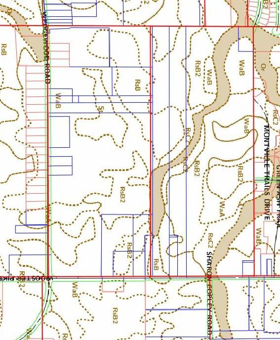
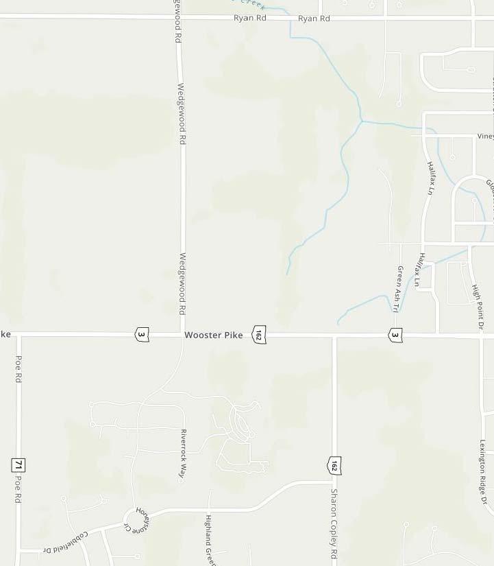
2 Hawks Ridge, Variances & Preliminary Plan Waterbury Drive (60 foot ROW) o Five permanent cul-de-sac streets (Streets B, C, F, I, and H [60 foot ROW]) Sanitary sewer Central water Six stormwater basins Access: Access to the site is provided by the proposed Grovewood Lane, Waterbury Drive, and Street A; Grovewood Lane (70 foot ROW) accesses Wooster Pike (SR 3) and Sharon Copley Road (SR 162) to the east and also provided access to the west, Waterbury Drive (60 foot ROW) provides access to the north, and Street A (60 foot ROW) accesses Wedgewood Drive (SR 162) to the south. Map 1: Location Map Grovewood Lane will complete the through street connection shown in the Medina Area Transportation Task Force 2001 Final Report as Project No. 33 the Southwest Connector. Site Conditions: The site is primarily used for agriculture; the western boundary is primarily wooded. The submitted Preliminary Plan and the Geographic Information System (GIS) data indicate several streams flowing from the south and east to the northwest. The site has gently rolling topography and is steeper adjacent to the stream and ponds. Several wetlands are located throughout the site. GIS data indicates that five gas/oil wells are located on the site. The GIS data lists the following well permit numbers: Zoning: The purpose of the R-2 District is to provide for the development of single-family residential dwellings on subdivided lots with a minimum lot size of 22,000 square feet, and controlled density planned residential developments to discourage large concentrations of intensive development where it is desirable to preserve reasonable amounts of open space and maintain the suburban character of the Township. Montville Township Zoning Resolution Section ( ) 410.1(D)(3). Controlled Density Planned Residential Developments (PRDs) are a permitted use in the district. Comprehensive Plan: The proposed subdivision is not consistent with the 2016 Montville Township Comprehensive Plan Update. The Future Land Use map, Figure LU.10, recommends the subject site for commercial use. Staff Comments: This report presents the two variance requests and Preliminary Plan. The Medina County Planning Commission (MCPC) must vote on each item separately. Dept. of Planning Services Page 2 of 9 February 6, 2019
3 Hawks Ridge, Variances & Preliminary Plan VARIANCE REQUEST # 1 1. The applicant has requested a variance to 604(C)(3) Access Points of the Medina County Subdivision Regulations (Regulations) which states that [n]o single access subdivision shall contain more than 50 dwelling units. 2. The applicant requests 65 dwelling units be permitted in Phase 1 of the subdivision until such time as a through street connection can be made in Phase 2; this is 15 units over the permitted maximum number of dwelling units or a 30% increase. 3. The following justifications for the variance were submitted by the applicant: a. As drawn, Phase 1 consists of 65 lots on a temporary cul-de-sac until Phase 2 is constructed. This variance request is temporary in nature and is only required until such time as construction of Phase 2 is complete. b. The most preferred development entrance cannot be constructed until after the Ohio Department of Transportation (ODOT) completes the traffic circle, which will not occur until This physical constraint requires the entrance to the development to be created from the south on Wedgewood Road. This entrance is complicated by the fact that the utilities are in the northwest corner of the site. c. While Street A could be stopped short at the 50 unit threshold and a temporary T- Turnaround added, during the Medina County Concept Planning meeting, Montville Township representatives expressed a preference that extending the street to the [southern] permanent cul-de-sac [on Street B ] provides a safer and more practical turn-around for the trucks. The proposed plan incorporates that revision and facilitates that request. We believe extending the road to the permanent cul-de-sac provides the safest and most practical configuration for Phase 1 of this development [clarification provided by author] (A)(2) of the Regulations stipulates the criteria for granting variances. The criteria are as follows (Staff comments regarding compliance with the criteria are shown in italics): a. In order to approve a variance, the MCPC must find that an unnecessary hardship may result from the strict application of the Regulations due to exceptional topographic or other conditions. An unreasonable hardship could result from the strict application of the regulation requiring the maximum number of sublots on a cul-de-sac to 40 due to exceptional topographic or other physical conditions; the applicant s preferred first entrance to the subdivision is Grovewood Lane to the east to Wooster Pike and Sharon-Copley Road, however they are unable to utilize this entrance until ODOT constructs the roundabout planned for the intersection in If the applicant was allowed to utilize Grovewood Lane as the first entrance to the subdivision, they would not be impacted by the 50 sublot rule; as presented, the subdivision shows 68 sublots are proposed with frontage on Grovewood Lane over two phases and as such compliance with the 50 sublot rule could be easily achieved without a variance. b. The MCPC may vary the Regulations so as to relieve an established hardship, provided such relief may be granted without detriment to the public interest and without impairing the intent and purpose of these regulations or the desirable development of the neighborhood and the community. The MCPC may grant relief to the applicant without detriment to the public interest and without impairing the desirable development of the community, in fact the proposed street alignment and layout reflects the township s wishes to have the Phase 1 streets be built up to and Dept. of Planning Services Page 3 of 9 February 6, 2019
4 Hawks Ridge, Variances & Preliminary Plan including the southern permanent cul-de-sac on Street B as it provides a safer and more practical turn-around for trucks. In addition, the MCPC may grant a variance as granting the variance will not impair the intent and purpose of the regulations. The Regulations, however, provide little guidance regarding how much of a variance to grant or how much of a variance is too much. In the past 10+ years the MCPC has granted nine variances for streets (between May 2007 and present); four for cul-de-sac length and five for the MCPC Date Sub. Reg. Description Limit Proposal Variance % 4/4/ (B)(9) Units on cul-de-sac % 1/3/ (B)(9) Units on cul-de-sac % 1/3/ (B)(9) Cul-de-sac length (ft) 2,500 2, % 12/6/ (B)(9) Cul-de-sac length (ft) 2,500 2, % 8/3/ (B)(9) Cul-de-sac length (ft) 2,500 2, % 1/8/ (B)(9) Units on cul-de-sac % 7/3/ (B)(9) Units on cul-de-sac % 12/7/ (B)(9) Units on cul-de-sac % 5/2/ (B)(9) Cul-de-sac length (ft) 2,500 3, % Table 1: MCPC Street Variance Summary number of sublots on a cul-de-sac. The range of percentage granted over the limits for these types of variances range from 5.00% to 37.56% (see Table 1 above). The average variance granted for all these variances is 19.83%. The MCPC must decide if the requested variance is reasonable, or if not, how much of a variance is appropriate to be granted (A)(2) of the Regulations also states that the MCPC action must not conflict with certain policies, as follows: a. In no instance shall a variance be granted for the sole purpose of increasing economic benefit to the applicant. Granting the variance does not solely increase the economic benefit to the applicant; the street layout is proposed, in part, as a response to a request of the township and still achieves the intent and purposes of the regulations. b. In no instance shall a variance be granted which has the effect of nullifying the intent and purposes of the Regulations or a valid township zoning resolution if such exists. Granting a variance would not have the effect of nullifying the intent and purposes of the Regulations or the Montville Township Zoning Resolution. Recommendation: DPS Staff recommends that the MCPC APPROVE a variance to 604(C)(3) of the Regulations limiting a single access subdivision to 50 dwelling units (Variance Request #1); the MCPC must decide if the requested variance is reasonable or if not, how much of a variance is appropriate to be granted. VARIANCE REQUEST # 2 1. The applicant has requested a variance to 604(B)(9) Stub Streets/Cul-De-Sacs of the Regulations which states: For greater convenience to traffic, more effective police and fire protection, and efficiency of road maintenance, permanent cul-de-sac streets shall not serve in excess of 40 dwelling units, nor have a length in excess of 2,500 feet. The length of the cul-de-sac street shall be measured along the centerline of the proposed cul-de-sac street from the centerline of the Dept. of Planning Services Page 4 of 9 February 6, 2019


5 Hawks Ridge, Variances & Preliminary Plan nearest existing or proposed intersecting through street to the center of the cul-de-sac turn around. 2. The applicant requests 49 dwelling units be permitted on Streets E and F, which when combined form an effective cul-de-sac; this is nine units over the permitted maximum number of dwelling units or a 22.5% increase. 3. The following justifications for the variance were submitted by the applicant: a. As drawn, Streets E and F contain 49 lots. This variance request is temporary in nature and is only required until such time as construction of Phase 2 is complete. b. A plan was presented during the Concept Plan [m]eeting which showed an additional [northern] connection on to Street E (see Map 2). [The Montville Service Department] expressed concerns that this connection location presented both safety and practical challenges. [Clarification provided by author]. Map 2: Extra street connection. Map 3: Current Plan (no connection). c. In addition to the aforementioned northern route we presented during the Concept Plan meeting, we also evaluated three additional methods of connecting Streets G and H to the south to address the 40 lot limitation. They are as follows: i. Extending Street H to Street A This route is not possible to the large block of wetlands to the south of Street H. Additionally, directly south of the wetlands provides the best natural location for stormwater management adjacent to the low elevation. ii. Extending a new street south from Street G to Street B - This connection is constrained due to steep topographic challenges and difficult ravine crossings. The terrain is very steep and would inhibit the intention of Dept. of Planning Services Page 5 of 9 February 6, 2019
6 Hawks Ridge, Variances & Preliminary Plan iii. preserving sensitive natural area. Our design goal is to have a full swath of land preserved from the eastern edge of the site to the western edge and minimize any crossings of that environmentally sensitive area. We currently have only one crossing planned. Extending Street G due west to Street B This extension is constrained due to wetlands, topography and the presence of the main gas line and therefore not practical. We believe the plan currently presented offers the least environmental impact, greatest safety and overall practical maintenance solutions. 4. Per 203(A)(2) the criteria for approving a variance are as follows (Staff comments regarding compliance with the criteria are shown in italics): a. The MCPC must find that an unnecessary hardship may result from the strict application of the Regulations due to exceptional topographic or other conditions. An unreasonable hardship could result from the strict application of the regulation requiring the maximum number of sublots on a cul-de-sac to 40 due to exceptional topographic or other physical conditions; the applicant s original preferred first street layout showed an additional street connection to Grovewood Lane (see Map 2). If the applicant was allowed to utilize the additional street connection to Grovewood Lane, they would not be impacted by the 40 sublot limit as a through street connection is created. The applicant elected not to create the through street connection in response to the Township Service Department concerns over safety and practical challenges presented by the proposed additional intersection with Grovewood Lane. b. The MCPC may vary the Regulations so as to relieve an established hardship, provided such relief may be granted without detriment to the public interest and without impairing the intent and purpose of these regulations or the desirable development of the neighborhood and the community. The MCPC may grant relief to the applicant without detriment to the public interest and without impairing the intent and purpose of the regulations or the desirable development of the community. The applicant demonstrates that other through street connections are not practical due to topographic issues and the locations of streams, wetlands, and a gas line. As indicated above, the Regulations provide little guidance regarding how much of a variance to grant or how much of a variance is too much. In the past 10+ years the MCPC has granted nine variances for streets, the range of the variances granted over the limits for all these types of variances range from 5.00% to 37.56% and the average variance granted is 19.83% (see Table 1 above). When specifically evaluating variances granted for the maximum number of sublots on a cul-de-sac, variances ranged from 5.00% to 25.00% and the average variance granted was 17.50%. The MCPC must decide if the requested variance is reasonable or if not, how much of a variance is appropriate to be granted (A)(2) of the Regulations also states that the MCPC action must not conflict with certain policies, as follows: a. In no instance shall a variance be granted for the sole purpose of increasing economic benefit to the applicant. Granting the variance does not solely increase Dept. of Planning Services Page 6 of 9 February 6, 2019
7 Hawks Ridge, Variances & Preliminary Plan the economic benefit to the applicant; the proposed street layout is proposed, in part, as a response to a request of the township and still achieves the intent and purposes of the regulations. b. In no instance shall a variance be granted which has the effect of nullifying the intent and purposes of the Regulations or a valid township zoning resolution if such exists. Granting a variance would not have the effect of nullifying the intent and purposes of the Regulations or the Montville Township Zoning Resolution. Recommendation: DPS Staff recommends that the MCPC APPROVE a variance to 604(B)(9) of the Regulations limiting a the number of dwelling units permitted on a cul-da-sac to 40 (Variance Request #2); the MCPC must decide if the requested variance is reasonable or if not, how much of a variance is appropriate to be granted. PRELIMINARY PLAN Agency Comments: Italicized text indicates quotations from submitting agency comments. Sanitary Engineer, Jeremy Sinko, 1/24/2019, APPROVED 1. Detailed engineering plans at the time of construction must meet the current rules and regulations for water and sanitary sewer per the Sanitary Engineer s Office. 2. Existing sanitary sewer utilities will need to be extended along property frontage abuts Wooster Pike Road (SR 3) and Wedgewood Road (SR 162). 3. The existing water main along Grovewood Lane must be extended and looped to the existing water mains along Wooster Pike Road (SR 3) and Wedgewood Road (SR 162). Highway Engineer, Matt Martin, 1/24/2019, DISAPPROVED 1. O.D.O.T. approval for S.R. 3 and S.R. 162 access. 2. The portion of Grovewood Lane within the Commercially Zoned frontage of SR 3 to have a thickened pavement section determined during construction plan review process. 3. Ensure any applicable Montville Township setbacks are shown (riparian and wells). 4. Drainage Maintenance Funds to be established. 5. Strictly maintain watersheds to mitigate negative impacts. 6. Provide/show storm sewer overland flood routes as part of the drainage design. 7. Rear storm sewer systems and easements should be located in open space if possible. Additional rear storm sewers may be required during construction plan review. 8. Montville Township to provide approval for rolled curb option. 9. Re-align Streets G and H intersection to provide a more defined intersection layout. 10. Street A to be upgraded to a minor collector due to anticipated traffic volumes. 11. Include the construction of the pavement at existing Grovewood Lane as part of the plan. 12. Remove Sublots 236 and 246 due to existing gas line. 13. Provide well and gas line owner contact information. 14. Prior to Preliminary Plan approval the developer is to provide standards from the gas company for street crossings. These standards may require significant revision to the subdivision layout. Ohio Department of Transportation (ODOT), Jared Feller, 1/24/2019. ODOT has no objections to the preliminary plan for the proposed Hawks Ridge subdivision. The developer has met with Dept. of Planning Services Page 7 of 9 February 6, 2019
8 Hawks Ridge, Variances & Preliminary Plan ODOT regarding the proposed access points along SR 3 and SR 162, and is aware of ODOT s permit requirements. A permit will need to be issued by ODOT for the proposed access point (Street A) shown along SR 162, west of SR 3. The developer will also construct the west leg of the proposed roundabout at the northern SR 3 & SR 162 intersection and plans to construct this access point after the completion of the ODOT roundabout project. The relocation of the existing Aspire gas main along Grovewood Lane on the west side of SR 3 will need to be determined. Where this gas main is relocated will affect how Aspire ties the gas main into a new Columbia Gas of Ohio pump house that will be constructed. A meeting was held in September 2018 with the developer, gas companies, and ODOT to discuss the relocation of the gas main. Medina Fire Department, Assistant Chief, Mark Crumley, 1/18/ Fire hydrants need to be located every 300 feet. 2. The fire hydrant side of the street will need signage that read No parking This Side of Street. Health Department, Christine Fienga, 1/10/2019. Public water and sewer: this office has no comment. Tax Maps, Beth Mika, 11/14/2018, APPROVED. Final plat will be subject to the Engineer Land Conveyance Standards found at: Montville Township, Planning and Zoning Director, Paul Jeffers, 11/14/2018, CONDITIONAL APPROVAL. The Concept Plan meets the total allowed homes and the open space requirements. The proposal of Phase I with greater than 50 homes per one access point would need to be approved by the Zoning Commission (with high emphasis on the MC Planning Commission also giving approval). Per discussion regarding the wetlands and the Category 2 setbacks of 75 feet, a variance will need to be granted for those areas in which the 75 feet cannot be met. HOA documents will need to be submitted for review by township legal counsel. TransCanada/Columbia Gas, Russ Johnson, 11/13/2018. APPROVED Soil and Water Conservation District, Jim Dieter, 11/5/2018 Wetland and stream areas must be clearly marked to limit construction and homeowner use. Open space areas behind building lots need to be marked so these areas do not become yard extensions for the homeowner. The [Homeowner s Association] (HOA) will need to monitor these areas. Signage should be installed to limit construction access. Wadsworth and Rittman soils are the primary soil of this development. The limitations of this soil are moderate wetness for homes with basements. Wetlands have been delineated on this site. They will need to be marked and protected. The storm water management ponds appear to be located in the open space areas. The HOA will need to make a plan in order to manage these ponds once the building phase of construction has been completed. The ponds will require maintenance that may include cleaning the pond due to sediment buildup and future dam/spillway maintenance. Dept. of Planning Services Page 8 of 9 February 6, 2019
9 Hawks Ridge, Variances & Preliminary Plan Staff Comments: 1. The applicant submitted the following documents as part of the Preliminary Plan application (Subdivision Regulations [Regulations] section references are included): a. Draft Declaration of Covenants, Conditions, Easements, and Restrictions of Crum Kowal Acres Subdivision: Montville Township, Medina County, Ohio. 404(C)(2)c.8 b. A copy of a letter dated October 1, 2018 from Teresa Spagna, Chief, North Branch, Huntington District, United States Army Corps of Engineers (USACE) indicating that the Preliminary Jurisdictional Determination has been issued for the proposed subdivision. 404(C)(2)c The following required data/information was not provided on or with the Preliminary Plan (Regulations section references are included): a. A copy of the Developers Notice of Intent to obtain an Ohio Environmental Protection Agency stormwater management permit (NOI) if applicable. 404(C)(2)d.7. Submit a copy of the NOI if applicable. b. Ten foot reservation strip[s are required] to control access from a stub street to undeveloped land within the dedicated right-of-way. 604(B)(8). Add access reservation easements at phase boundaries to limit access to the streets. 3. The proposed subdivision substantially meets the standards and requirements of the Regulations per 404(C)(4)b The applicant HAS NOT submitted evidence indicating that the proposed subdivision meets the standards and requirements of the Montville Township Zoning Resolution per 404(C)(4)b The Sanitary Engineer has determined the subdivision will be adequately serviced by sanitary sewer subject to approval of detailed plans per 404(C)(4)b The Highway Engineer HAS NOT determined the Preliminary Plan for streets, stormwater management and natural drainage ways protection is acceptable subsequent to the approval of more detailed construction drawings per 404(C)(4)b.3. Recommendation: DPS Staff recommends that the MCPC APPROVE WITH MODIFICATION the Preliminary Plan for Hawks Ridge subdivision subject to the following: 1. Submit the required data/information as listed above on or with the Preliminary Plan. 2. Submit evidence indicating that the proposed subdivision meets the standards and requirements of the Montville Township Zoning Resolution. 3. Satisfy the above listed comments from the Highway and Sanitary Engineers. 4. Satisfy the above listed comments from the Medina City Fire Department. The applicant shall provide all requested documentation and three full size copies of the corrected Preliminary Plan (including a PDF copy of the layout) prior to Final Plat submission. Attachments: GIS map Preliminary Plan Variance narrative R:\wp\planning\major_subdivisions\2019\hawks_ridge_preplan_var\hawks_ridge_preplan_variances_ docx Dept. of Planning Services Page 9 of 9 February 6, 2019
10
11
12
13
14
15
16
17

18 387 Medina Road, Suite 1700 :: Medina, OH :: :: fax Hawks Ridge Development Application for Variance Submittal Variance Request # 1 - Article VI, 604, C, 3. Access Points: No single access subdivision shall contain more than 50 dwelling units. As drawn, Phase 1 consists of 65 lots on a temporary cul-de-sac until Phase 2 is constructed. This variance request is temporary in nature and is only required until such time as construction of Phase 2 is complete. The most preferred development entrance cannot be constructed until after ODOT completes the traffic circle, which will not occur until This physical constraint requires the entrance to the development to be created from the south on Wedgewood Road. This entrance is complicated by the fact that the utilities are in the northwest corner of the site. While Street A could be stopped short at the 50 unit threshold and a temporary T-Turnaround added, during the Medina County Concept Planning meeting, Montville Township representatives expressed a preference that extending the street to the permanent cul-de-sac provides a safer and more practical turn-around for the trucks. The proposed plan incorporates that revision and facilitates that request. Streets G & H will not be constructed until a later phase and therefore are not included in the 65 lots. We believe extending the road to the permanent cul-de-sac provides the safest and most practical configuration for phase 1 of this development. Variance Request # 1 - Article VI, 604, B, 9. Cul-de-sac Dwelling Units: Permanent cul-desac streets shall not serve in excess of 40 dwelling units. As drawn, Streets R & F contain 49 lots. This design has been studied and we believe the current design presents the most practical design solution. This requested variance is a combination of requested changes from Montville Township and physical/environmental design challenges. A plan was presented during the Medina County Concept Planning Meeting which showed an additional connection on to Street E. All parties expressed concerns that this connection location presented both safety challenges and practical challenges for the Montville Service Department. Page 1 of 2
19 387 Medina Road, Suite 1700 :: Medina, OH :: :: fax In addition to the aforementioned northern route we presented during the Concept Planning meeting, we also evaluated three additional methods of connecting Streets G & H to the south to address the 40 lot limitation. They are as follows: Extending Street H to Street A This route is not possible to the large block of wetlands to the south of Street H. Additionally, directly south of the wetlands provides the best natural location for stormwater management adjacent to the low elevation. Extending a new street south from Street G to Street B - This connection is constrained due to steep topographic challenges and difficult ravine crossings. The terrain is very steep and would inhibit the intention of preserving sensitive natural area. Our design goal is to have a full swath of land preserved from the eastern edge of the site to the western edge and minimize any crossings of that environmentally sensitive area. We currently have only 1 crossing planned Extending Street G due west to Street B This extension is constrained due to wetlands, topography and the presence of the main gas line and therefore not practical. We believe the plan currently presented offers the least environmental impact, greatest safety and overall practical maintenance solutions. We are therefore requesting these two variances for your consideration. Page 2 of 2
Planning Commission Preliminary Plan Hidden Lakes Estates Medina Township EXECUTIVE SUMMARY
 Planning Commission Preliminary Plan Hidden Lakes Estates Medina Township Meeting: January 2, 2019 App. No.: 105-2018-PP Applicant: Hidden Lake Medina, LLC Engineer: Cunningham & Associates, LLC Parcel
EXECUTIVE SUMMARY. Access: Access to the site is by the proposed extension of Stockbridge Drive.
 Variance & Final Plat Preserve at Trillium Creek, Ph. 1 Montville Township Meeting: January 2, 2019 App. No.: 096-2018-FP Applicant: Haslinger Holdings Owners: Trillium Creek LLC Engineer: Lewis Land Prof.
Planning Commission Preliminary Plan LRC Subdivision Montville Township
 Planning Commission Preliminary Plan LRC Subdivision Montville Township Meeting: February 1, 2017 App. No.: 002-2017-PP Owner: Faith & Hope Land Dev. Co. Applicant: Montville Investors LLC Engineer: Weber
Final Plat Trails at Redwood Falls, Ph. 1 Hinckley Township EXECUTIVE SUMMARY
 Final Plat Trails at Redwood Falls, Ph. 1 Hinckley Township Meeting: December 5, 2018 App. No.: 069-2017-PP Owner: Skyland Land Company LLC Engineer: TGC Engineering, T. Crane Parcel Nos.: 016-03A-38-012,
Commission Planning Final Plat Ledges of Stone Creek Hinckley Township EXECUTIVE SUMMARY
 Commission Planning Final Plat Ledges of Stone Creek Hinckley Township Meeting: February 1, 2017 App. No.: 127-2016-FP Applicant: Legacy-Carrington Dev. Group Engineer: TGC Engineering, LLC Parcel: 016-03A-39-003
Planning Commission Final Plat Liverpool Fields, Phase 3 Liverpool Township App. No PP EXECUTIVE SUMMARY
 Planning Commission Final Plat Liverpool Fields, Phase 3 Liverpool Township App. No. 59-21-PP Meeting: August 6, 21 Applicant: Pride One Liverpool, LLC Owner: Pride One Liverpool, LLC Engineer: TGC Engineering
Planning Commission Replat Arbor Lakes at Cobblestone Park, Ph. 10 Montville Township
 Planning Commission Replat Arbor Lakes at Cobblestone Park, Ph. 10 Montville Township Meeting: May 4, 2016 App. No.: 037-2016-R Developer: Cobblestone Park Development Group, LLC Surveyor: TGC Engineering
EXECUTIVE SUMMARY. Block A9, acres Cobblestone Park PND
 Planning Commission Replat Arbor Lakes at Cobblestone Park Subdivision, Phase 9 Montville Township App. No. 04-2015-R Meeting: February 4, 2015 Developer: Cobblestone Park Development Group, LLC Surveyor:
Planning Commission Replat Falcon Pointe at Lake Medina Reserve, Ph. 3 Medina Township
 Planning Commission Replat Falcon Pointe at Lake Medina Reserve, Ph. 3 Medina Township Meeting: December 7, 2016 App. No.: 115-2016-R Applicant: W.J. Bailey Homes Owner: Crossbow Development Inc. Engineer:
Planning Commission Final Plat Riverview Villas of Stonegate Medina Township App. No FP EXECUTIVE SUMMARY
 Planning Commission Final Plat Riverview Villas of Stonegate Medina Township App. No. 077-2014-FP Meeting: October 1, 2014 Applicant: Stonegate Center, LLC Ken Cleveland Engineer: Lewis Land Professionals,
Planning Commission Preliminary Plan Riverview Villas of Stonegate Medina Township App. No PP EXECUTIVE SUMMARY
 Planning Commission Preliminary Plan Riverview Villas of Stonegate Medina Township App. No. 088-2013-PP Meeting: January 8, 2014 Applicant: Stonegate Center, LLC Ken Cleveland Engineer: Lewis Land Professionals,
Planning Commission Revised Preliminary Plan & Final Plat Maplebrooke Reserve Subdivision Montville Township EXECUTIVE SUMMARY
 Planning Commission Revised Preliminary Plan & Final Plat Maplebrooke Reserve Subdivision Montville Township Meeting: October 5, 2016 App. No.: 091-2016 RPP and 093-2016-FP Applicant: Cambridge Service
Staff Report: Date: Applicant: Property Identification: Acreage of Request: Current Zoning of Requested Area: Requested Action: Attached:
 Staff Report: Completed by Jeff Palmer Director of Planning & Zoning Date: November 7, 2018, Updated November 20, 2018 Applicant: Greg Smith, Oberer Land Developer agent for Ronald Montgomery ET AL Property
Staff Report: Date: Applicant: Property Identification: Acreage of Request: Current Zoning of Requested Area: Requested Action: Attached:
 Staff Report: Completed by Jeff Palmer Director of Planning & Zoning Date: November 7, 2018 Applicant: Greg Smith, Oberer Land Developer agent for Ronald Montgomery ET AL Property Identification: Frontage
MCPC Members and Alternates in Attendance:
 MEDINA COUNTY PLANNING COMMISSION MINUTES OF MEETING WEDNESDAY, JANUARY 3, 2018, 6:30 P.M. PROFESSIONAL BUILDING, LOWER LEVEL CONFERENCE ROOM Attendees / Representing (from sign-in sheet): William Spellman,
Planning Commission Text & Map Amendments Pavluk Properties Hinckley Township EXECUTIVE SUMMARY
 Planning Commission Text & Map Amendments Pavluk Properties Hinckley Township Meeting: August, 08 App. No.: 05-08-MA & TA Owner: The Pavluk Family Limited Partnership Applicant: Zoning Commission (Terry
M-43 CORRIDOR OVERLAY ZONE
 ARTICLE 26.00 M-43 CORRIDOR OVERLAY ZONE Section 26.01 Findings A primary function of the M-43 state highway is to move traffic through the Township and to points beyond. As the primary east-west arterial
Section Preliminary Plat Checklist and Application Forms
 Section 201 - Preliminary Plat Checklist and Application Forms PRELIMINARY SUBDIVISION PLAT REVIEW PROCESS CHART PRELIMINARY SUBDIVISION PLAT APPLICATION PRELIMINARY PLAT REVIEW CHECKLIST CITY OF NAMPA
MAJOR RESIDENTIAL AND NONRESIDENTIAL SUBDIVISIONS
 Lawrence-Douglas County MAJOR RESIDENTIAL AND NONRESIDENTIAL SUBDIVISIONS Preliminary Plats The applicant shall schedule a Pre-Application meeting with Planning Staff at least seven (7) working days prior
ARTICLE 24 PRIVATE ROAD, SHARED PRIVATE DRIVEWAY AND ACCESS EASEMENT STANDARDS
 ARTICLE 24 PRIVATE ROAD, SHARED PRIVATE DRIVEWAY AND ACCESS EASEMENT STANDARDS SECTION 24.00 INTENT AND PURPOSE The standards of this Article provide for the design, construction and maintenance of private
Draft Model Access Management Overlay Ordinance
 Draft Model Access Management Overlay Ordinance This model was developed using the City of Hutchinson and the Trunk Highway 7 corridor. The basic provisions of this model may be adopted by any jurisdiction
ARTICLE 23 CONDOMINIUM STANDARDS
 ARTICLE 23 CONDOMINIUM STANDARDS Section 23.01 Intent. The intent of this Article is to provide regulatory standards for condominiums and site condominiums similar to those required for projects developed
ELK RAPIDS TOWNSHIP ANTRIM COUNTY, MICHIGAN ORDINANCE NO
 ELK RAPIDS TOWNSHIP ANTRIM COUNTY, MICHIGAN ORDINANCE NO. 3-2011 AN ORDINANCE TO REPLACE THE SUBDIVISION CONTROL ORDINANCE WITH A NEW SUBDIVISION DEVELOPMENT ORDINANCE, IN ACCORD WITH THE LAND DIVISION
Residential Major Subdivision Review Checklist
 Residential Major Subdivision Review Checklist Plan Submittal Requirements: 2 full sets of stamped plans Electric submittal - all plans contained in a single PDF 3 full sets if commercial kitchen or dining
Residential Minor Subdivision Review Checklist
 Residential Minor Subdivision Review Checklist Plan Submittal Requirements: 2 full sets of stamped plans Electric submittal - all plans contained in a single PDF 3 full sets if commercial kitchen or dining
EXTRA TERRITORIAL ZONING AUTHORITY CASE ANALYSIS
 DOÑA ANA COUNTY CASE # V09-007 COMMUNITY PLANNING AND ECONOMIC DEVELOPMENT DEPARTMENT Building Planning GIS 845 North Motel Boulevard Las Cruces, New Mexico 88007 (575) 647-7350 Fax: (575) 525-6131 Toll
SUBDIVISION AND LAND DEVELOPMENT. 185 Attachment 20
 185 Attachment 20 APPENDIX S Plat No. Date of Submission Twp. Fee $ Dauphin Co. Fee $ TOWNSHIP OF DERRY SUBDIVISION OR LAND DEVELOPMENT PLAN SUBMISSION APPLICATION This block for Twp. use only 1. Title
APPLICATION PROCEDURE
 ANTRIM PLANNING BOARD P. O. Box 517 Antrim, New Hampshire 03440 Phone: 603-588-6785 FAX: 603-588-2969 APPLICATION FORM AND CHECKLIST FOR MINOR OR MAJOR SITE PLAN REVIEW File Date Received By APPLICATION
I. Requirements for All Applications. C D W
 108-16.1. Application checklists. Checklist for Required Submissions to the Planning Board or Zoning Board of Adjustment of Monroe Township All required submissions are to be made to the Administrative
HERON LANDING SUBDIVISION
 HERON LANDING SUBDIVISION Engineering Comments: Per FEMA guidelines, any development greater than 5 acres in size or subdivision 50 lots in size, requires a flood study. Width of drainage easement to be
SUBDIVISION APPLICATION CHECKLIST SKETCH PLAN PRELIMINARY PLAT FINAL PLAT
 RECEIVED STAMP SUBDIVISION APPLICATION CHECKLIST SKETCH PLAN PRELIMINARY PLAT FINAL PLAT A checklist of background information and submission requirements for processing of a sketch plan, preliminary plat
REPORT TO THE SHELBY COUNTY PLANNING COMMISSION From the Department of Development Services Planning Services. February 4, 2019
 REPORT TO THE SHELBY COUNTY PLANNING COMMISSION From the Department of Development Services Planning Services February 4, 2019 Case No. Request for Rezoning Approval From E-1 to E-2 SD This is a request
610 LAND DIVISIONS AND PROPERTY LINE ADJUSTMENTS OUTSIDE A UGB
 ARTICLE VI: LAND DIVISIONS AND PROPERTY LINE ADJUSTMENTS VI-21 610 LAND DIVISIONS AND PROPERTY LINE ADJUSTMENTS OUTSIDE A UGB 610-1 Property Line Adjustments (Property Line Relocation) A property line
The following information is for use by the Lincoln County Planning Board at their meeting/public hearing on February 3, 2014.
 LINCOLN COUNTY PLANNING & INSPECTIONS DEPARTMENT 302 NORTH ACADEMY STREET, SUITE A, LINCOLNTON, NORTH CAROLINA 28092 704-736-8440 OFFICE 704-736-8434 INSPECTION REQUEST LINE 704-732-9010 FAX To: Planning
Town of Falmouth s Four Step Design Process for Subdivisions in the Resource Conservation Zoning Overlay District
 Town of Falmouth s Four Step Design Process for Subdivisions in the Resource Conservation Zoning Overlay District All subdivisions shall be designed in accordance with the following four-step process.
FINAL DRAFT 12/1/16, Rev. to 7/18/17
 FINAL DRAFT 12/1/16, Rev. to 7/18/17 (As Adopted 8/8/17 Effective 9/1/17) SHELTON PLANNING AND ZONING COMMISSION Proposed Amendments to Zoning Regulations I. Amend Section 23 PERMITTED USES by inserting
Initial Subdivision Applications Shall Include the Following:
 Initial Subdivision Applications Shall Include the Following: 1) Subdivision Application Form: completely filled out (12 copies) 2) Plat: The Plat must adhere to the requirements set forth in the Town
Township of Collier 2418 Hilltop Road Presto, PA 15142
 Township of Collier 2418 Hilltop Road Presto, PA 15142 Fees: Major: 2 checks $600 + $50 per lot & $1700 Escrow) APPLICATION FOR SUBDIVISION major FINAL only Plans must be folded Rolled plans will not be
SECTION 4: PRELIMINARY PLAT
 SECTION 4: PRELIMINARY PLAT After the completion of the sketch plan process, if submitted, the owner or developer shall file with the City an application for preliminary plat. The preliminary plat stage
ARTICLE 15. RULES, REGULATIONS AND DEFINITIONS
 ARTICLE 15. RULES, REGULATIONS AND DEFINITIONS Section 1. Interpretation and Construction: The following rules and regulations regarding interpretation and construction of the Ulysses-Grant County, Kansas,
# 6 Case #SUB LEGACY SUBDIVISION. Engineering Comments: Must comply with the Mobile County Flood Damage Prevention Ordinance.
 LEGACY SUBDIVISION Engineering Comments: Must comply with the Mobile County Flood Damage Prevention Ordinance. The plat illustrates the proposed 46 lot, 26.7 + acres subdivision which is located on the
MAJOR SUBDIVISION PRELIMINARY PLAT CHECKLIST
 TOWNSHIP OF EGG HARBOR PLANNING BOARD/ZONING BOARD OF ADJUSTMENT 3515 BARGAINTOWN ROAD EGG HARBOR TOWNSHIP, NJ 08234 MAJOR SUBDIVISION PRELIMINARY PLAT CHECKLIST The following checklist is designed to
ARTICLE 15 - PLANNED UNIT DEVELOPMENT
 Section 15.1 - Intent. ARTICLE 15 - PLANNED UNIT DEVELOPMENT A PUD, or Planned Unit Development, is not a District per se, but rather a set of standards that may be applied to a development type. The Planned
Open Space Model Ordinance
 Open Space Model Ordinance Section I. Background Open space development has numerous environmental and community benefits, including: 1) Reduces the impervious cover in a development. Impervious cover
c) Stub streets shall be required as follows:
 Stub streets shall be required as follows:") Sec. 7.2.1 / Streets 7.2 DESIGN STANDARDS 7.2.1 Streets A) Interconnectivity 1) Conformity with Apex Transportation Plan. The subdivision s street system shall conform to the Apex Transportation Plan.
Sec. 7.2.1 / Streets 7.2 DESIGN STANDARDS 7.2.1 Streets A) Interconnectivity 1) Conformity with Apex Transportation Plan. The subdivision s street system shall conform to the Apex Transportation Plan.
The following information is for use by the Lincoln County Planning Board at their meeting/public hearing on December 4, 2017.
 LINCOLN COUNTY PLANNING & INSPECTIONS DEPARTMENT 302 NORTH ACADEMY STREET, SUITE A, LINCOLNTON, NORTH CAROLINA 28092 704-736-8440 OFFICE 704-736-8434 INSPECTION REQUEST LINE 704-732-9010 FAX To: Planning
BEAR CREEK TOWNSHIP EMMET COUNTY, MICHIGAN. PRIVATE ROAD ORDINANCE Ordinance No. 11A-99. (to replace prior Private Road Ordinance No.
 BEAR CREEK TOWNSHIP EMMET COUNTY, MICHIGAN PRIVATE ROAD ORDINANCE Ordinance No. 11A-99 (to replace prior Private Road Ordinance No. 11-99) An Ordinance to protect the health, safety, and general welfare
Attached is a Clinton Township Zoning Permit Application and requirements for issuance of a permit.
 To Whom It May Concern: Attached is a Clinton Township Zoning Permit Application and requirements for issuance of a permit. The fee for the permit application is $75.00, which shall be made payable to
Administrative Plat Application Form
 1 Administrative Plat Application Form This form shall be submitted with each application for an administrative plat. CONTACT INFORMATION Applicant Architect (if different) Property Owner (if different)
Chapter 100 Planned Unit Development in Corvallis Urban Fringe
 100.100 Scope and Purpose. Chapter 100 Planned Unit Development in Corvallis Urban Fringe (1) All applications for land divisions in the Urban Residential (UR) and Flood Plain Agriculture (FPA) zones within
New Private Way Ordinance Westbrook Planning Board Workshop , Planning Board Public Hearing Definitions
 201 Definitions Private Right of Way; Private way A strip of land at least fifty feet wide, meeting the minimum standards for the construction of a gravel base for a public road, over which abutters may
APPLICATION SUBMITTAL REQUIREMENTS FOR Tentative Parcel or Subdivision Maps
 CITY OF EL CERRITO Community Development Department Planning and Building Division 10890 San Pablo Avenue, El Cerrito, CA 94530 (510) 215-4330 FA (510) 233-5401 planning@ci.el-cerrito.ca.us APPLICATION
MINUTES OF THE LAKE COUNTY PLANNING COMMISSION July 31, 2007
 MINUTES OF THE LAKE COUNTY PLANNING COMMISSION July 31, 2007 The Lake County Planning Commission hereby finds and determines that all formal actions were taken in an open meeting of this Planning Commission
FINAL SUBDIVISION AND LAND DEVELOPMENT PLAN CHECKLIST. Plan Name. Applicant's Name:
 TOWNSHIP OF UPPER ST. CLAIR FINAL SUBDIVISION AND LAND DEVELOPMENT PLAN CHECKLIST Date Filed Plan Name PLC Applicant's Name: Phone Filing Date for Final Application Final Plat 114.22. FINAL APPLICATION
O-I (Office-Institutional) and AG-1(Agricultural)
 and AG-1(Agricultural)") PROPERTY INFORMATION ADDRESS 3503 and 3505 Bethany Bend DISTRICT, LAND LOTS 2/1 973 and 974 OVERLAY DISTRICT State Route 9 PETITION NUMBERS EXISTING ZONING O-I (Office-Institutional) and AG-1(Agricultural)
PROPERTY INFORMATION ADDRESS 3503 and 3505 Bethany Bend DISTRICT, LAND LOTS 2/1 973 and 974 OVERLAY DISTRICT State Route 9 PETITION NUMBERS EXISTING ZONING O-I (Office-Institutional) and AG-1(Agricultural)
PLANNING COMMISSION REPORT REGULAR AGENDA
 PP-4-4-11 Item No. 9-1 PLANNING COMMISSION REPORT REGULAR AGENDA PC Staff Report 06/22/11 ITEM NO 9: PRELIMINARY PLAT; KASOLD WATER TOWER ADDITION; SE OF TAM O SHANTER & KASOLD DR (MKM) PP-4-4-11: Consider
DAUPHIN CREEK ESTATES SUBDIVISION
 # 12 SUB-000076-2017 DAUPHIN CREEK ESTATES SUBDIVISION Engineering Comments: FINAL PLAT COMMENTS (should be addressed prior to submitting the FINAL PLAT for review and/or signature by the City Engineer):
AUTUMNDALE SUBDIVISION, RESUBDIVISION OF LOTS
 AUTUMNDALE SUBDIVISION, RESUBDIVISION OF LOTS 100-102 Engineering Comments: Road shall be constructed per City standards and according to the City s street acceptance process. Cul-de sac approval subject
APPLICATION FOR SUBDIVISION APPROVAL OF A SKETCH PLAN with checklist
 Prior to filing any application for SUBDIVISION approval, the applicant shall request in writing that the zoning administrator schedule a pre-submission conference. APPLICATION TO THE PLANNING BOARD TOWN
PLANNING FOR OUR FUTURE
 PLANNING FOR OUR FUTURE ELLSWORTH TOWNSHIP LAND USE AND POLICY PLAN The purpose of this Plan is to serve as a guide for the Township Trustees, Zoning Commission, Board of Zoning Appeals, developers, employers,
Clearcreek Township Zoning Staff Report Soraya Farms Section 6 Stage 3 Review Page 1 of 8
 Staff Report: Completed by Jeff Palmer Director of Planning & Zoning Report Date: September 10, 2018 Meeting Date: October 1, 2018 Applicant: Shery Oakes, agent for Soraya Farms Requested Action: Soraya
TOWN OF LEWISTON PLANNING BOARD APPLICATION
 TOWN OF LEWISTON PLANNING BOARD APPLICATION DESCRIPTION OF PROPOSED REQUEST: Name of Property Owner: Phone #: Name of Applicant:Phone #: Address or Location of Proposal:_SBL# Size of Parcel or Structure:Existing
ORDINANCE NO. Be it ordained by the City Council of the City of Abilene, Texas:
 ORDINANCE NO. An ordinance repealing Chapter 23, Subpart B of the Code of the City of Abilene, Texas, entitled Mobile Homes and Vacation Travel Trailers; stating the authority; setting forth the scope
1.94 acres. Gwinnett Prado, L.P. c/o Brogdon Consulting Duluth, GA Contact: Ted Sandler
 Land Use Petition RZ-15-006 Date of Staff Recommendation Preparation: April 21, 2015 Revised to Incorporate Planning Commission Recommendations: 5/6/15 PROJECT LOCATION: 10800 Block of State Bridge Road
MONTGOMERY COUNTY PLANNING DEPARTMENT THE MARYLAND-NATIONAL CAPITAL PARK AND PLANNING COMMISSION
 MONTGOMERY COUNTY PLANNING DEPARTMENT THE MARYLAND-NATIONAL CAPITAL PARK AND PLANNING COMMISSION MCPB Item No.: Date: 06-21-12 The Plantations, Preliminary Plan -120090240 Benjamin Berbert, Senior Planner,
CITY OF FERNDALE HEARING EXAMINER
 CITY OF FERNDALE HEARING EXAMINER RE: Planned Unit Development ) 16001-PUD Preliminary Plat ) 16018-SE Plat Variance ) 16002-VAR Application by ) ) MD General, L.L.C. ) FINDINGS OF FACT, Malloy Heights
Chapter Plat Design (LMC)
") Chapter 18.14 Plat Design (LMC) Sections: 18.14.010 Lot width 18.14.020 Right-of-way requirements 18.14.030 Pipe stem lots 18.14.040 Division resulting in minimum lot sizes 18.14.050 Flood prone and bad
Chapter 18.14 Plat Design (LMC) Sections: 18.14.010 Lot width 18.14.020 Right-of-way requirements 18.14.030 Pipe stem lots 18.14.040 Division resulting in minimum lot sizes 18.14.050 Flood prone and bad
THE COUNTY BOARD OF SUPERVISORS OF THE COUNTY OF DOUGLAS DOES ORDAIN AS FOLLOWS:
 8.1 SUBDIVISION CONTROL ORDINANCE THE COUNTY BOARD OF SUPERVISORS OF THE COUNTY OF DOUGLAS DOES ORDAIN AS FOLLOWS: SECTION I. GENERAL INTERPRETATION This ordinance shall not repeal, impair or modify private
PALM BEACH COUNTY ENGINEERING DEPARTMENT. ZONING COMMISSION SUBDIVISION VARIANCE STAFF REPORT October 1, 2015
 PALM BEACH COUNTY ENGINEERING DEPARTMENT ZONING COMMISSION SUBDIVISION VARIANCE STAFF REPORT October 1, 2015 APPLICATION NO. CODE REQUIRED PROPOSED VARIANCE SECTION SD-147 11.E.9.B.2 When lots are platted
-MENDOCINO COUNTY PLANNING AND BUILDING SERVICES- DIVISION OF LAND REGULATIONS TITLE 17
 ARTICLE VI -- GENERAL REGULATIONS AND PROVISIONS Sec. 17-50. Sec. 17-51 General Plan. Sec. 17-52 Lot and Block Design and Configuration. Sec. 17-53 Lot Access. Sec. 17-54 Private Roads. Sec. 17-55 Water
CITY OF INVER GROVE HEIGHTS 8150 Barbara Avenue Inver Grove Heights, MN (651)
") 8150 Barbara Avenue Inver Grove Heights, MN 55077 (651) 450-2545 www.invergroveheights.org FINAL PLANNED UNIT DEVELOPMENT (City Code Section 10-13A) The following must be submitted prior to review and
8150 Barbara Avenue Inver Grove Heights, MN 55077 (651) 450-2545 www.invergroveheights.org FINAL PLANNED UNIT DEVELOPMENT (City Code Section 10-13A) The following must be submitted prior to review and
CITY OF HOBBS ORDINANCE NO..
 CITY OF HOBBS ORDINANCE NO.. AN ORDINANCE TO AMEND TITLE 16 OF THE HOBBS MUNICIPAL CODE IN ITS ENTIRETY. BE IT ORDAINED BY THE GOVERNING BODY OF THE CITY OF HOBBS, NEW MEXICO, that the following Chapter
DEVELOPMENT DEPARTMENT STAFF REPORT THE PARK AT 5 TH
 DEVELOPMENT DEPARTMENT STAFF REPORT ARB Meeting Date: July 3, 2018 Item #: _PZ2018-293_ THE PARK AT 5 TH Request: Site Address: Project Name: Parcel Number: Applicant: Proposed Development: Current Zoning:
Plans shall be drawn at a readable scale, signed, and sealed by a Florida Registered Engineer. The application package shall include:
 CHAPTER 400. SECTION 403. PERMIT TYPES AND APPLICATIONS SITE DEVELOPMENT 403.3. Preliminary Site Plans (PSP) A. Intent and Purpose PSPs are used to identify existing site conditions and demonstrate general
TOWNSHIP OF DOYLESTOWN APPLICATION FOR REVIEW OF SUBDIVISION OR LAND DEVELOPMENT PROPOSAL. Please PRINT; all information MUST be filled out completely
 TOWNSHIP OF DOYLESTOWN APPLICATION FOR REVIEW OF SUBDIVISION OR LAND DEVELOPMENT PROPOSAL Please PRINT; all information MUST be filled out completely Date: Name of Subdivision or Land Development: Location:
TOWN OF ELIOT PLANNING BOARD SUBDIVISION APPLICATION
 TOWN OF ELIOT PLANNING BOARD SUBDIVISION APPLICATION This application shall conform in all respects to the Land Subdivision Standards of Chapter 41 of the Planning Board of the Town of Eliot code of ordinances.
8Land Use. The Land Use Plan consists of the following elements:
 8Land Use 1. Introduction The Land Use Plan consists of the following elements: 1. Introduction 2. Existing Conditions 3. Opportunities for Redevelopment 4. Land Use Projections 5. Future Land Use Policies
Letter of Intent May 2017 (Revised November 2017)
") THE BEACH AT WOODMOOR LETTER OF INTENT MAY 2017 (REVISED NOVEMBER 2017) OWNER/APPLICANT: CONSULTANT: Lake Woodmoor Holdings LLC N.E.S. Inc. 1755 Telstar Drive, Suite 211 619 North Cascade Avenue Colorado
THE BEACH AT WOODMOOR LETTER OF INTENT MAY 2017 (REVISED NOVEMBER 2017) OWNER/APPLICANT: CONSULTANT: Lake Woodmoor Holdings LLC N.E.S. Inc. 1755 Telstar Drive, Suite 211 619 North Cascade Avenue Colorado
3. Will there be any amenities provided for the apartment or townhouse area, such as play areas or trails?
 .._ - Cityof Maple Grove MEMORANDUM TO: FROM: Elm Creek Estates File Dick Edwards, Community Development Director DATE: December 27,2016 SUBJECT: Community Development Staff Comments 1. Code requires a
A. Appropriate agency responsible for transportation review for the subject property.
 7.8.10 Procedure Any person desiring to create a minor subdivision shall submit to the Commission for approval an application on forms provided by the Division, and a record plat in conformance with the
ATTENDING THE MEETING Robert Balogh, Vice-Chairman Sonia Stopperich, Supervisor Marcus Staley, Supervisor Bob Ross, Supervisor
 SPECIAL HEARING - TUESDAY, APRIL 12, 2016 PAGE 1 The North Strabane Township Board of Supervisors held a Special Meeting- Conditional Use Hearing, Tuesday, April 12, 2016, at approximately 6:30 P.M., at
CONDOMINIUM REGULATIONS
 ARTICLE 37 CONDOMINIUM REGULATIONS SECTION 37.01. Purpose The purpose of this Article is to regulate projects that divide real property under a contractual arrangement known as a condominium. New and conversion
ARTICLE VI. SUBDIVISION STANDARDS, PUBLIC
 ARTICLE VI. SUBDIVISION STANDARDS, PUBLIC IMPROVEMENTS, AND DESIGN REQUIREMENTS ARTICLE VI. SUBDIVISION STANDARDS, PUBLIC IMPROVEMENTS, AND DESIGN REQUIREMENTS DIVISION 1. GENERAL PROVISIONS Sec. 21-6100.
Town of Lisbon, Maine SUBDIVISION REVIEW APPLICATION
 Date Received: Fee Paid (amount): Applicant: Town of Lisbon, Maine SUBDIVISION REVIEW APPLICATION Subdivision Name/Title: This application must be received at the Town Office by close of business on the
ARTICLE 16 SUBDIVISIONS
 ARTICLE 16 SUBDIVISIONS 16.1 Subdivision Regulations 16.1-1. Purpose. The regulations for the subdivision of land set forth below are established to promote orderly growth and development; provide for
PLANNING COMMISSION REPORT Regular Agenda Non Public Hearing Item
 PC Staff Report 3/23/15 FDP-14-00551 Item No. 2-1 PLANNING COMMISSION REPORT Regular Agenda Non Public Hearing Item PC Staff Report 3/23/15 ITEM NO. 2: FINAL DEVELOPMENT PLAN FOR HUTTON FARMS WEST PHASE
Kitsap County Department of Community Development
 Kitsap County Department of Community Development Staff Report and Recommendation Annual Comprehensive Plan Amendment Process for 2018 George s Corner LAMIRD Boundary Adjustment Report Date 7/16/2018 Hearing
THE AREA PLAN COMMISSION OF ST. JOSEPH COUNTY, IN AGENDA
 THE AREA PLAN COMMISSION OF ST. JOSEPH COUNTY, IN AGENDA Tuesday, June 20, 2017 Fourth-Floor Council Chambers 3:30 p.m. County-City Building, South Bend, IN PUBLIC HEARINGS: 1. Rezonings: A. A combined
PLYMOUTH PLANNING BOARD APPLICATION FOR A MINOR SUBDIVISION OR MAJOR SUBDIVISION
 CASE # PLYMOUTH PLANNING BOARD APPLICATION FOR A MINOR SUBDIVISION OR MAJOR SUBDIVISION The undersigned Applicant hereby submits to the Plymouth Planning Board a completed application for a proposed minor
City of Prior Lake APPLICATION FOR COMBINED PRELIMINARY AND FINAL PLAT
 Case File No. Property Identification No. City of Prior Lake APPLICATION FOR COMBINED PRELIMINARY AND FINAL PLAT Requested Action Brief description of proposed project (Please describe the proposed amendment,
MASTER SUBDIVISION FINAL PLAT APPLICATION Town of Apex, North Carolina
 MASTER SUBDIVISION FINAL PLAT APPLICATION Town of Apex, North Carolina This document is a public record under the North Carolina Public Records Act and may be published to the Town s website or disclosed
PRELIMINARY PLATS. The following documents are provided as required by the City of Conroe for use in the above titled platting submittals:
 Public Works Engineering Division CITY OF CONROE PRELIMINARY PLATS The following documents are provided as required by the City of Conroe for use in the above titled platting submittals: Submittal Questionnaire
Group Sewer Only** 80 Ft Frontage* 20,000 Sq. Ft. (.46 acre) Minimum** 120 Ft Frontage* 20,000 Sq. Ft. (.46acre) Minimum** 150 Ft Frontage*
 Minimum** 120 Ft Frontage* 20,000 Sq. Ft. (.46acre) Minimum** 150 Ft Frontage*") Residential Lots Minimum Chart The minimum lot size of any minor subdivision where there is no public sewers shall be as shown below or as required by township zoning and/or the Tuscarawas General Health
Residential Lots Minimum Chart The minimum lot size of any minor subdivision where there is no public sewers shall be as shown below or as required by township zoning and/or the Tuscarawas General Health
MINOR SUBDIVISION FINAL PLAT APPLICATION Town of Apex, North Carolina
 MINOR SUBDIVISION FINAL PLAT APPLICATION Town of Apex, North Carolina This document is a public record under the North Carolina Public Records Act and may be published on the Town s website or disclosed
Preliminary Subdivision Application (Minor) (Three (3) lots or less)
 (Three (3) lots or less)") Gunnison City Offices www.gunnisoncity.org 38 West Center Gunnison, Utah 84634 (435) 528 7969 Date of Application: Preliminary Subdivision Application (Minor) (Three (3) lots or less) APPLICANT INFORMATION
Gunnison City Offices www.gunnisoncity.org 38 West Center Gunnison, Utah 84634 (435) 528 7969 Date of Application: Preliminary Subdivision Application (Minor) (Three (3) lots or less) APPLICANT INFORMATION
CHAPTER 1268 R-1-F (SINGLE FAMILY RESIDENTIAL, GOLF COURSE COMMUNITY)
") CHAPTER 1268 R-1-F (SINGLE FAMILY RESIDENTIAL, GOLF COURSE COMMUNITY) 1268.01 PURPOSE: The R-1-F (Single Family Residential - Golf Course Community) zoning district has been established to permit residential
CHAPTER 1268 R-1-F (SINGLE FAMILY RESIDENTIAL, GOLF COURSE COMMUNITY) 1268.01 PURPOSE: The R-1-F (Single Family Residential - Golf Course Community) zoning district has been established to permit residential
Cover Letter with Narrative Statement
 Cover Letter with Narrative Statement March 31, 2017 rev July 27, 2017 RE: Rushton Pointe Residential Planned Unit Development Application for Public Hearing for RPUD Rezone PL2015 000 0306 Mr. Eric Johnson,
Deerfield Township Community Development Department
 STAFF REVIEW Deerfield Township Community Development Department To: From: Hayfaa Wadih, AICP Lois McKnight, AICP Meeting Date: October 20, 2014 Continued from October 13, 2014 Re: Major PUD Modification
Preliminary Subdivision Application (Major) (Four (4) lots or more)
 (Four (4) lots or more)") Gunnison City Offices www.gunnisoncity.org 38 West Center Gunnison, Utah 84634 (435) 528 7969 Date of Application: Preliminary Subdivision Application (Major) (Four (4) lots or more) APPLICANT INFORMATION
Gunnison City Offices www.gunnisoncity.org 38 West Center Gunnison, Utah 84634 (435) 528 7969 Date of Application: Preliminary Subdivision Application (Major) (Four (4) lots or more) APPLICANT INFORMATION
GENEVA TOWNSHIP VAN BUREN COUNTY, MICHIGAN SUBDIVISION/SITE CONDOMINIUM DEVELOPMENT ORDINANCE #32 ADOPTED: May 9, 2006 Amendment #1 January 9, 2007
 GENEVA TOWNSHIP VAN BUREN COUNTY, MICHIGAN SUBDIVISION/SITE CONDOMINIUM DEVELOPMENT ORDINANCE #32 ADOPTED: May 9, 2006 Amendment #1 January 9, 2007 An Ordinance to regulate and control the subdivision