ANSWERS TO QUESTIONS IN VARIATION APPLICATION
|
|
|
- Osborn Fleming
- 5 years ago
- Views:
Transcription
1
2
3
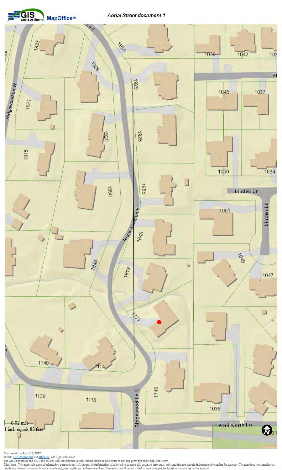
4 ANSWERS TO QUESTIONS IN VARIATION APPLICATION BACKGROUND: Working with Cliff Town of Town Studios Architects and Cliff Toberman of Toberman & Associates Civil Engineers and Surveyors petitioner, the architect, and the engineer on the project have compiled the answers to the questions from the variation application below. Cliff Town can be contacted for further clarification at Town Studio Architects 1297 Shermer Rd, Northbrook, IL Tel. (847) Cliff Toberman can be contacted at Toberman & Associates, LLC 115 S. Wilke Road, Suite 301, Arlington Heights, IL Tel: Petitioner is looking to construct a new single-family detached residence at the front yard setback of 30 feet instead of a minimum front yard setback of feet. 2. The irregular shape of the lot being on one side and on the other create particular challenge in constructing conventional home while creating private backyard area for the family to enjoy. In addition to having irregular lot shape the topography of the lot and the large swale running through the yard further reduce the usability of the lot. The swale along northern line of the lot and the eastern line of the lot is lined with mature trees the owner wishes to preserve as much as possible. When all of these factors are combined this places significant burden on the design and placement of the home on the lot. The topography and the shape of the lot do not present many choices about the placement of the home. Placing a home on the required setback of house causes the home to be located in the close proximity of the existing drainage patterns (please refer to the geodetic site plan showing the overflow patterns and the house placed at feet). The southeast corner of the house would be located approximately 20 feet from the existing swale which will put burden on the drain tile and sump pump during large rain event. Furthermore, placing the house at feet setback will not follow existing conditions and will require substantial alteration of existing ground elevations. Per discussion with the civil engineer on this project best practices call for doing as little alterations as possible to existing ground elevations. Please see attached letter from Toberman Engineering and the geodetic site plan showing both setbacks and overflow routes. 3. Ridgewood is not a typical street on a rectangular grid. The curving nature of Ridgewood produces varying front yard setbacks for each home. Unlike many other Glenview streets, there is no common rhythm or theme for the setbacks. As the street meanders, the front yard distances become randomized. (See Aerial Street document 1). The Aerial Street document 1 has a line drawn on it to demonstrate what the setback of the house to the north would be like had the street been straight. In this case for 1777 Ridgewood, the road makes a bend to the West to produce an artificially large setback for the neighboring home to the
5 ANSWERS TO QUESTIONS IN VARIATION APPLICATION North. This creates a setback penalty for the subject property, if the setback average is used. The property to the North is rather an outlier. If you look at the homes to the South of 1777 E. Ridgewood where Ridgewood lane straightens out the homes at 1749, 1741, and 1737 all have front yard setback around feet or so. Namely 1749 is at feet, 1741 is feet and 1737 is at feet, please see attached surveys and the Aerial Street Document 2. In addition if you draw a straight line through the properties to the North (see Aerial Street document 1) the front yard setback becomes similar to the existing setback of feet at Ridgewood. Averaging the setbacks with the neighbor properties which include one unique outlier creates a large front yard setback for In addition the large swale running the property is clearly a unique condition and is not found elsewhere further complicating home positioning and usability. 4. Building the home at front yard setback will not introduce dramatic changes to the look and feel of the neighborhood. a. The existing property is built at front setback. b. The neighboring home to the North is rotated away from the property because of the bend in the road to the West and as such there is no impact to the supply of light or air. In addition two homes are separated by existing swale lined with mature trees which further reduces any potential impact of homes on each other. On the other hand positioning the home at required setback would create a bigger negative impact on the house to the north because it would bring the houses closer together reducing the privacy of the backyards for both of them. c. Position of the roadway within the right-of-way would make my home appear further away from the street because of the distance from pavement to my front line. The neighbor s pavement to the north is much closer (actually encroaching) to their front line. d. Coming from the South end of the Ridgewood before Kenilworth Lane homes will appear much more uniform in their front setbacks. e. Should the property to the North be ever redeveloped it is likely to be pushed closer to the front line as that would be more optimal location. 5. We have considered different potential locations of the house on the lot as well as different designs of the house. One of the requirements of the homeowners is having a first floor bedroom for their aging parents. The homeowners wish to have customary patio placement accessible from the kitchen and eating area. The irregular shape of the lot makes it impossible to position the home any other way and have a simple home layout without further sacrificing usability of the house and the backyard. 6. Because of the unique shape and topography of the lot the proposed location of the house is the only viable option. The Applicant is not looking for the least expensive construction option, the cost of constructing the proposed home will the same irrespective of the position of the house. At the same time applicant is looking to construct a home of substantial value contributing to the overall appeal of the
6 ANSWERS TO QUESTIONS IN VARIATION APPLICATION neighborhood. If the home was to be constructed with the required front yard setback the marketability of the final product would be significantly reduced due to the irregular shape of the lot and very limited if awkward resulting backyard area. Should the home be ever put up for sale the appeal and the usability of the home will suffer substantially thus reducing the resale value. In addition extra engineering work would be required to mitigate close proximity of the existing overflow route, please refer to the letter from Toberman Engineering for more details.
 April 12, 2017 Re: 1777 E. Ridgewood Lane, Glenview The following outlines the site problems created by adhering to a Village required 53.")
7 Civil Engineers & Surveyors 115 S. Wilke Road, Suite 301 Arlington Heights, IL Phone: Fax: Web: Design Firm No (Expires 04/30/17) April 12, 2017 Re: 1777 E. Ridgewood Lane, Glenview The following outlines the site problems created by adhering to a Village required 53.5' yard front-yard building setback. The first noteworthy item is that the property is not trapezoidal shaped, which results in the south side-yard lot line being only 103.5' whereas the north side-yard lot line is 197'+/-. This results in a rear yard width that varies significantly from north to south resulting in a much smaller usable rear-yard area than typical rectangular lots. Thus, having the required Village front-yard setback results in a hardship for typical use of a rear yard that would include a patio area, usable lawn area as well as room for any future addition(s). To create additional lawn area under these circumstances would require the removal of existing mature/quality trees that are better served as a buffer between the adjacent properties. Regarding overall site drainage, the property's existing topography channels offsite storm water drainage around the perimeter of the site in swales towards the southeast rear corner of the property. Also, there is an existing drainage structure located at the southwest corner of the property that ties into the recent storm sewer improvements along Ridgewood lane. Off-site drainage routes through the site must be maintained under proposed home/lot development plans in the event that the existing storm sewer becomes overloaded. Per a discussion with the Village, the south overflow route shall remain unchanged. Having the required Village front-yard setback results in a hardship since the rear building foundation would be within 20' of off-site drainage route through the rear/east portion of the site. Equally important, the foundation would be in close proximity to possible sub-surface groundwater that would cause the sump pump to be frequently running and prone to failure. Another hardship would be the financial incremental costs of having to fill the existing home's foundation and having to excavate a significant more quantity of soil for the new foundation and basement. The desired front-yard setback would be at the existing 30' where higher ground existing today and existing basement area expanded (vs. filled). Thus, the basement would be less prone to subsurface drainage concerns now or in the future. Sincerely, Cliff J. Toberman Cliff J. Toberman, P.E. Principal Engineer 1
8
9
10
11
12

13
14 U:\2017 JOBS\h 2017 Glenview Homes\ (PROPOSED NEW RESIDENCE) 1777 E. Ridgewood Lane (GLENVIEW)\ ( DK) Full Required Setback.dwg, 4/13/2017 1:57:06 PM
15 U:\2017 JOBS\h 2017 Glenview Homes\ (PROPOSED NEW RESIDENCE) 1777 E. Ridgewood Lane (GLENVIEW)\ ( DK) 30 Foot Setback.dwg, 4/13/2017 1:56:46 PM
16

17
18
 THAT PART OF LOT 33 LYING SOUTHERLY OF THE FOLLOWING DESCRIBED LINE: BEGINNING ON THE EAST LINE OF LOT 33, 57.")

 17.")
 // // // // // W.F. 1/2\" SIR C-1 5/8\" FIP 29.77' 103.29' (R) S 90 00'00\" W 103.53' (M) LOT 32 5/8\" FIP 0.")
19 S 0 04'11" E ' (M) PROPERTY ADDRESS: 1777 E RIDGEWOOD LANE EAST GLENVIEW, ILLINOIS SURVEY NUMBER: IL FIELD WORK DATE: 11/14/2016 REVISION DATE(S): (REV.0 11/15/2016) THAT PART OF LOT 33 LYING SOUTHERLY OF THE FOLLOWING DESCRIBED LINE: BEGINNING ON THE EAST LINE OF LOT 33, 57.0 FEET SOUTH OF THE NORTHEAST CORNER OF LOT 33, THENCE SOUTHWESTERLY ALONG A LINE MAKING AN ANGLE WITH THE SAID EAST LINE OF 61 DEGREES, NO MINUTES, ( AS MEASURED FROM SOUTH TO WEST) A DISTANCE OF FEET, THENCE WESTERLY 78.0 FEET MORE OR LESS TO A POINT ON THE WESTERLY LINE OF SAID LOT 33, 73.0 FEET SOUTH OF THE ANGLE POINT IN SAID WESTERLY LINE (AS MEASURED ALONG SAID WESTERLY LINE) SAID ANGLE POINT BEING ALSO THE MOST WESTERLY CORNER OF LOT 33, ALL IN GLEN OAK ACRES, BEING A SUBDIVISION IN THE WEST 1/2 OF THE WEST 1/2 OF SECTION 25, TOWNSHIP 42 NORTH, RANGE 12, EAST OF THE THIRD PRINCIPAL MERIDIAN, IN COOK COUNTY, ILLINOIS. 25.0' N 67 08'18" E 78.56' (M) 17.14' REMAINDER OF LOT 33 (NOT INCLUDED) 122.0' (R) N 61 00'17" E ' (M) 12.81' PART OF SQ.FT.± X X X X X X X 1/2" SIR 3.4' OFF 3.3' OFF 5/8" FIP 73.22' N 35 53'47" W ' (R) ' (M) // // // // // W.F. 1/2" SIR C-1 5/8" FIP 29.77' ' (R) S 90 00'00" W ' (M) LOT 32 5/8" FIP 0.7' OFF STATE OF ILLINOIS COUNTY OF GRUNDY } SS THIS IS TO CERTIFY THAT THIS PROFESSIONAL SERVICE CONFORMS TO THE CURRENT ILLINOIS MINIMUM STANDARDS FOR A BOUNDARY SURVEY. GIVEN UNDER MY HAND AND SEAL THIS 14TH DAY OF NOVEMBER, 2016 AT 316 E. JACKSON STREET IN MORRIS, IL ILLINOIS PROFESSIONAL LAND SURVEYOR No LICENSE EXPIRES 11/30/2018 EXACTA LAND SURVEYORS LB# 5763 KENN ST A T ETH PROFESSIONAL LAND SURVEYOR MORRIS, IL E O F A. I L KENNEDY L O I N S I N THE ABOVE SURVEY IS A PROFESSIONAL SERVICE IN COMPLIANCE WITH THE MINIMUM STANDARDS OF THE STATE OF ILLINOIS. NO IMPROVEMENTS SHOULD BE MADE ON THE BASIS OF THIS PLAT ALONE. PLEASE REFER ALSO TO YOUR DEED, TITLE POLICY AND LOCAL ORDINANCES. COPYRIGHT BY EXACTA ILLINOIS SURVEYORS. THIS DOCUMENT MAY ONLY BE USED BY THE PARTIES TO WHICH IT IS CERTIFIED. PLEASE DIRECT QUESTIONS OR COMMENTS TO EXACTA ILLINOIS SURVEYORS, INC. AT THE NUMBER IN THE BOTTOM RIGHT CORNER. POINTS OF INTEREST NONE VISIBLE CLIENT NUMBER: DATE: 11/15/2016 BUYER: ALEXANDER GAVRILOV AND ANNA GAVRILOV SELLER: CATHERINE M. LA PLANTE AS TRUSTEE OF CATHERINE M. LA PLANTE DECLARATION OF TRUST DATED JULY 21, 2014 CERTIFIED TO: ALEXANDER GAVRILOV AND ANNA GAVRILOV; CHICAGO TITLE INSURANCE COMPANY; ITS SUCCESSORS AND/OR ASSIGNS; AS THEIR INTERESTS MAY APPEAR This is page 1 of 2 and is not valid without all pages.
20 REPORT OF SURVEY IL This is page 2 of 2 and is not valid without all pages. LEGAL DESCRIPTION: THAT PART OF LOT 33 LYING SOUTHERLY OF THE FOLLOWING DESCRIBED LINE: BEGINNING ON THE EAST LINE OF LOT 33, 57.0 FEET SOUTH OF THE NORTHEAST CORNER OF LOT 33, THENCE SOUTHWESTERLY ALONG A LINE MAKING AN ANGLE WITH THE SAID EAST LINE OF 61 DEGREES, NO MINUTES, ( AS MEASURED FROM SOUTH TO WEST) A DISTANCE OF FEET, THENCE WESTERLY 78.0 FEET MORE OR LESS TO A POINT ON THE WESTERLY LINE OF SAID LOT 33, 73.0 FEET SOUTH OF THE ANGLE POINT IN SAID WESTERLY LINE (AS MEASURED ALONG SAID WESTERLY LINE) SAID ANGLE POINT BEING ALSO THE MOST WESTERLY CORNER OF LOT 33, ALL IN GLEN OAK ACRES, BEING A SUBDIVISION IN THE WEST 1/2 OF THE WEST 1/2 OF SECTION 25, TOWNSHIP 42 NORTH, RANGE 12, EAST OF THE THIRD PRINCIPAL MERIDIAN, IN COOK COUNTY, ILLINOIS. JOB SPECIFIC SURVEYOR NOTES: SURVEYOR BEARINGS ARE USED FOR ANGULAR REFERENCE AND ARE USED TO SHOW ANGULAR RELATIONSHIPS OF LINES ONLY AND ARE NOT RELATED OR ORIENTATED TO TRUE OR MAGNETIC NORTH. BEARINGS ARE SHOWN AS SURVEYOR BEARINGS, AND WHEN SHOWN AS MATCHING THOSE ON THE SUBDIVISION PLATS ON WHICH THIS SURVEY IS BASED, THEY ARE TO BE DEEMED NO MORE ACCURATE AS THE DETERMINATION OF A NORTH ORIENTATION MADE ON AND FOR THOSE ORIGINAL SUBDIVISION PLATS. NORTH 0 DEGREES EAST IS ASSUMED AND UPON PREPARATION OF THIS PLAT, THE RESULTING BEARING BETWEEN FOUND POINTS AS SHOWN ON THIS SURVEY IS THE BASIS OF SAID SURVEYOR BEARINGS AS DEFINED AND REQUIRED TO BE NOTED BY ILLINOIS ADMINISTATIVE CODE TITLE 68, CHAPTER 12, SUBCHAPTER b, PART 1270, SECTION , PARAGRAPH b, SUBPARAGRAPH 6, ITEM K. GENERAL SURVEYOR NOTES: 1. The Legal Description used to perform this survey was supplied by others. The survey does not determine or imply ownership. 2. This survey only shows improvements found above ground. Underground footings, utilities and encroachments are not located on this survey map Any additions or deletions to this 2 page survey document are strictly prohibited. 6. Dimensions are in feet and decimals thereof. 7. Due to varying construction standards, house dimensions are approximate All pins marked as set are 5/8 diameter, 18 iron rebar Points of Interest (POI's) are selected above-ground improvements which may be in conflict with boundary, building setback or easement lines, as defined by the parameters of this survey. There may be additional POI's which are not shown, not called-out as POI's, or which are otherwise unknown to the surveyor. These POI's may not represent all items of interest to the viewer. 12. Utilities shown on the subject property may or may not indicate the existence of recorded or unrecorded utility easements. 13. The information contained on this survey has been performed exclusively, and is the sole responsibility, of Exacta Surveyors. Additional logo or references to third party firms are for informational purposes only. 14. House measurements should not be used for new construction or planning. Measurements should be verified prior to such activity. LEGEND: A/C B.R. B.C. B.F.P. BLK. BLDG. BM B.R.L. BSMT. B/W (C) C CATV C.B. CHIM. C.L.F. C.O. CONC. COR. CS/W C.V.G. C/L C/P C/S (D) D.F. D.H. D/W ELEV. ENCL. ENT. EM F.O.P. E.O.W. EUB (F) FCM F/DH F.F. FIP FIPC FIR FIRC FN FN&D FND. FPKN FPKN&D FRRSPK GAR. GM AIR CONDITIONING BEARING REFERENCE BLOCK CORNER BACKFLOW PREVENTOR BLOCK BUILDING BENCHMARK BUILDING RESTRICTION LINE BASEMENT BAY/BOX WINDOW CALCULATED CURVE CABLE TV RISER CONCRETE BLOCK CHIMNEY CHAIN LINK FENCE CLEAN OUT CONCRETE CORNER CONCRETE SIDEWALK CONCRETE VALLEY GUTTER CENTER LINE COVERED PORCH CONCRETE SLAB DEED DRAIN FIELD DRILL HOLE DRIVEWAY ELEVATION ENCLOSURE ENTRANCE ELECTRIC METER EDGE OF PAVEMENT EDGE OF WATER ELECTRIC UTILITY BOX FIELD FND. CONCRETE MONUMENT FOUND DRILL HOLE FINISHED FLOOR FOUND IRON PIPE FOUND IRON PIPE & CAP FOUND IRON ROD FOUND IRON ROD & CAP FOUND NAIL FOUND NAIL AND DISC FOUND FOUND PARKER-KALON NAIL FOUND PK NAIL & DISC FOUND RAILROAD SPIKE GARAGE GAS METER ID. ILL. INST. INT. L LB# LS# (M) M.B. M.E.S. M.F. N.R. N.T.S. O.C.S. O.G. OFF OH. OHL ON O.R.B O.R.V. O/A O/S (P) P.B. P.C. P.C.C. P.C.P. P/E PG. P.I. PLS PLT P.O.B. P.O.C. P.P. P.R.C. P.R.M. PSM P.T. R (R) RGE. RES. R/W (S) S.B.L. S.C.L. SCR. IDENTIFICATION ILLEGIBLE INSTRUMENT INTERSECTION LENGTH LICENSE # - BUSINESS LICENSE # - SURVEYOR MEASURED MAP BOOK MITERED END SECTION METAL FENCE NON RADIAL NOT TO SCALE ON CONCRETE SLAB ON GROUND OUTSIDE OF SUBJECT PARCEL OVERHANG OVERHEAD LINES INSIDE OF SUBJECT PARCEL OFFICIAL RECORD BOOK OFFICIAL RECORD VOLUME OVERALL OFFSET PLAT PLAT BOOK POINT OF CURVATURE POINT OF COMPOUND CURVATURE PERMANENT CONTROL POINT POOL EQUIPMENT PAGE POINT OF INTERSECTION PROFESSIONAL LAND SURVEYOR PLANTER POINT OF BEGINNING POINT OF COMMENCEMENT PINCHED POPE POINT OF REVERSE CURVATURE PERMANENT REFERENCE MONUMENT PROFESSIONAL SURVEYOR AND MAPPER POINT OF TANGENCY RADIUS or RADIAL RECORD RANGE RESIDENCE RIGHT OF WAY SURVEY SET BACK LINE SURVEY CLOSURE LINE SCREEN SEC. SEP. SEW. S/GD SIRC SN&D SQ.FT. STY. S.T.L. SV S/W S.W. TBM TEL. T.O.B. TWP. TX TYP. U.R. W/C W/F W.F. WM WV V.F. A.E. AN.E. C.M.E. C.U.E. D.E. D.U.E. ESMT. I.E./E.E. IRR.E. L.A.E. L.B.E. L.E. L.M.E. M.E. P.U.E. R.O.E. S.W.E. S.W.M.E. T.U.E. U.E. SECTION SEPTIC TANK SEWER SET GLUE DISC SET IRON ROD & CAP SET NAIL & DISC SQUARE FEET STORY SURVEY TIE LINE SEWER VALVE SIDEWALK SEAWALL TEMPORARY BENCHMARK TELEPHONE FACILITIES TOP OF BANK TOWNSHIP TRANSFORMER TYPICAL UTILITY RISER WITNESS CORNER WATER FILTER WOODEN FENCE WATER METER/VALVE BOX WATER VALVE VINYL FENCE ACCESS EASEMENT ANCHOR EASEMENT CANAL MAINTENANCE ESMT. COUNTY UTILITY ESMT. DRAINAGE EASEMENT DRAINAGE AND UTILITY ESMT. EASEMENT INGRESS/EGRESS ESMT. IRRIGATION EASEMENT LIMITED ACCESS ESMT. LANDSCAPE BUFFER ESMT. LANDSCAPE ESMT. LAKE OR LANDSCAPE MAINTENANCE EASEMENT MAINTENANCE EASEMENT PUBLIC UTILITY EASEMENT ROOF OVERHANG ESMT. SIDEWALK EASEMENT STORM WATER MANAGEMENT EASEMENT TECHNOLOGICAL UTILITY ESMT. UTILITY EASEMENT ELECTRONIC SIGNATURE: In order to Electronically Sign all of the PDFs sent by STARS, you must use a hash calculator. A free online hash calculator is available at To Electronically Sign any survey PDF: 1. Save the PDF onto your computer. 2. Use the online tool at to browse for the saved PDF on your computer. 3. Select the Hash Method as SHA. 4. Click Submit. Your PDF is electronically signed if all of the characters in the SHA-1 code submitted by STARS matches the code which is produced by the hash calculator. If they match exactly, your PDF is electronically signed. If the codes do not match exactly, your PDF is not authentic. PRINTING INSTRUCTIONS: 1. While viewing the survey in Adobe Reader, select the Print button under the File tab. 2. Select a printer with legal sized paper. 3. Under Print Range, click select the All toggle. 4. Under the Page Handling section, select the number of copies that you would like to print. 5. Under the Page Scaling selection drop down menu, select None. 6. Uncheck the Auto Rotate and Center checkbox. 7. Check the Choose Paper size by PDF checkbox. 8. Click OK to print. TO PRINT IN BLACK + WHITE: 1. In the main print screen, choose Properties. 2. Choose Quality from the options. 3. Change from Auto Color or Full Color to Gray Scale. OFFER VALID ONLY FOR THE BUYERS LISTED ON THE FIRST PAGE OF THIS SURVEY: *Offer valid for fence stakeouts and additions to the existing structures only. Offer valid only for the buyer as listed on the first page of this survey. Total discount not to exceed $500. Coupon expires 2 years from the date of issuance. *
21
22

23
24

25
26
Palm Ave Hialeah Building Data Palm Avenue
 400-450 Palm Ave Hialeah Building Data Address 400-450 Palm Avenue City, State Hialeah, Florida County Miami Dade parcel # 04-3118-001-1950 and 1960 Zoning Retail Commercial - BU2 Land Size 13500 Type
PLAT OF SURVEY VICINITY MAP (NOT TO SCALE) N N W E SITE BENCHMARK # 2 W E N&D ON BACK OF CURB NAVD 88 S S 0' 10' 20' 40' 60' 1" = 20' TOP=106.7
 N N W E SITE BENCHMARK # 2 W E N&D ON BACK OF CURB NAVD 88 S S 0' 10' 20' 40' 60' 1 = 20' TOP=106.7") PLAT OF SURVEY VICINITY MAP (NOT TO SCALE) N N W E SITE BENCHMARK # 2 W E N&D ON BACK OF CURB 106.21 NAVD 88 S S 0' 10' 20' 40' 60' 1" = 20' TOP=106.72 N INV PVC=99.27 S INV PVC=99.32 E INV CLAY=99.39
PLAT OF SURVEY VICINITY MAP (NOT TO SCALE) N N W E SITE BENCHMARK # 2 W E N&D ON BACK OF CURB 106.21 NAVD 88 S S 0' 10' 20' 40' 60' 1" = 20' TOP=106.72 N INV PVC=99.27 S INV PVC=99.32 E INV CLAY=99.39
AIR ONE. 829 HULL ROAD Ormond Beach, Florida BENCHMARK #1 EL NAIL IN POWER POLE EASTERLY RIGHT-OF-WAY LINE TOMOKA AIRPORT ROAD (UR) HULL ROAD
 HULL ROAD") NORTH LINE LOT 2 SOUTH LINE LOT 1 S75 46'55"E 2 NORTH LINE LOT 3 SOUTH LINE LOT 2 N75 43'32"W(UR) S75 43'32"E(D) N75 43'32"W(URD) NORTH LINE LOT 1 SOUTH LINE LOT 12 225.15'(M)225'(UR) P.O.R. PARCELS II
NORTH LINE LOT 2 SOUTH LINE LOT 1 S75 46'55"E 2 NORTH LINE LOT 3 SOUTH LINE LOT 2 N75 43'32"W(UR) S75 43'32"E(D) N75 43'32"W(URD) NORTH LINE LOT 1 SOUTH LINE LOT 12 225.15'(M)225'(UR) P.O.R. PARCELS II
Standards of Practice for Surveying in the State of Alabama
 Standards of Practice for Surveying in the State of Alabama Effective January 1, 2017 RULE NO. 1.01 PURPOSE The purpose of these rules is to establish standards for the practice of surveying in the State
CERTIFIED SURVEY MAP
 SCONSIN STATE PLANE N:389676.12 E:2130390.15 Center of Section 23 CERTIFIED SURVEY MAP 734.06' THE (PRITCHETTE) ORIGINAL PLAT OF ALL IN THE NW 1 4 OF THE SE 1 4 OF FRACTIONAL SECTION 23, T7N, R9E, IN THE
SECTION SITE SURVEYS
 PART 1 - GENERAL 1.1 DESCRIPTION SECTION 02 21 00 SPEC WRITER NOTES: 1. Use this section only for NCA projects. 2. Delete between //---// if not applicable to project. Also delete any other item or paragraph
SITE TO BE DEMOLISHED
 STE TO BE DEMOLSHED City Hall/Moca 357' 2 7 3 Subject 97,400sf magery 2017 Google, Map data 2017 Google 200 ft -----------------,...j J2J_ t --... --F-Lj-\u:111-ii-1-1-1:f1-1-111-L/-t "l(pkgje1 '_-o 15(PK6)135'-0"
DETAILED GRADING PLAN CHECKLIST (TEARDOWN/REDEVELOPMENT)
") GENERAL DETAILED GRADING PLAN CHECKLIST (TEARDOWN/REDEVELOPMENT) ADDRESS: PERMIT #: DATE: 1. Plan is signed and sealed by an Illinois registered professional engineer including date signed and license
GENERAL DETAILED GRADING PLAN CHECKLIST (TEARDOWN/REDEVELOPMENT) ADDRESS: PERMIT #: DATE: 1. Plan is signed and sealed by an Illinois registered professional engineer including date signed and license
Development Review Committee Application
 City of Coral Gables, Florida Level 2 Review Development Review Committee Application Address: 427 Biltmore Way, 2 nd Floor, Coral Gables, Florida 33134 Email: planning@coralgables.com Phone: 305.460.5211
DIVISION 2 - CONSTRUCTION PLAN AND MISCELLANEOUS REQUIREMENTS
 DIVISION 2 - CONSTRUCTION PLAN AND MISCELLANEOUS REQUIREMENTS 2.1 Required Plan Sheets 2.2 Drawing Requirements 2.3 Graphic Standards 2.4 Easements 2.5 Utility Locations 2.6 Private Facility Locations
DETAILED GRADING PLAN CHECKLIST (TEARDOWN/REDEVELOPMENT) Updated: 12/12/2017
 Updated: 12/12/2017") DETAILED GRADING PLAN CHECKLIST (TEARDOWN/REDEVELOPMENT) Updated: 12/12/2017 ADDRESS: PERMIT #: DATE: Sat. Not GENERAL 1. A disposition of comments should be included in all subsequent submittals. 2. Plan
DETAILED GRADING PLAN CHECKLIST (TEARDOWN/REDEVELOPMENT) Updated: 12/12/2017 ADDRESS: PERMIT #: DATE: Sat. Not GENERAL 1. A disposition of comments should be included in all subsequent submittals. 2. Plan
Plan Presentation Guide SECTION 60. Chapter 3 RIGHT-OF-WAY SECTION PRESENTATION
 Chapter 3 RIGHT-OF-WAY SECTION PRESENTATION Right of Way plans are necessary for the acquisition of the required right of way and easements for projects. Proper representation of the right of way and easements
PLANNING COMMISSION REPORT Non-Public Hearing Item
 PC Staff Report 09/21/2015 Item No. 2B - 1 PLANNING COMMISSION REPORT Non-Public Hearing Item PC Staff Report 09/212015 ITEM NO. 2B: FINAL PLAT FOR MORGAN ADDITION; 800 MONTEREY WAY (MKM) : Consider a
R/W PREQUALIFICATION ODOT, 3/14/2018
 R/W PREQUALIFICATION ODOT, 3/14/2018 BRETT SHEARER, C.O. REAL ESTATE PROPOSED RIGHT OF WAY DESIGN 172 PROPOSED RIGHT OF WAY DESIGN PROPOSED RIGHT OF WAY DESIGN Section 3200 Types of Title 173 PROPOSED
CITY OF PORT ST LUCIE
 CITY OF PORT ST LUCIE COUNCIL AGENDA MEMORANDUM Agenda Item #: 11B Meeting Date: 5/22/17 TO: Mayor and City 1Council 2 VIA: Russ Blackburrit, ity Manager Patricia Roeblirg, P.E., Assistant City Manager
DAWSON COUNTY MINOR PLAT REVIEW CHECKLIST $50.00 FEE PER PLAT REVIEW, $5.00 FEE FOR SCAN & CD FOR RECORDING
 DAWSON COUNTY MINOR PLAT REVIEW CHECKLIST $50.00 FEE PER PLAT REVIEW, $5.00 FEE FOR SCAN & CD FOR RECORDING NAME ON PLAT: CONTACT/PHONE #: NAMED STREET/ADDRESS: LAND LOT: DISTRICT: SECTION: ZONING: SETBACKS:
Enforcement of Minimum Survey Standards
 Presented By: F. Anthony Rettke, P.S., Tax Map Supervisor, Franklin County John Greenhalge, Executive Director, State Board of Registration n the Ohio Revised Code, Section 315.251: If a deed conveying
ABBREVIATION LEGEND SITE INFORMATION:
 SITE INFORMATION: Current Zone: R-3 PUD, governed by Fox Hollow 2nd MDA Basis of Elevations: Northeast Corner of Section 13, T6S, R1W, S.L.B. & M Elevation: 4599.26 (Benchmark) ABBREVIATION LEGEND Owners:
ARTICLE 13 CONDOMINIUM REGULATIONS
 ARTICLE 13 CONDOMINIUM REGULATIONS Section 13.01 Purpose. The purpose of this Article is to regulate projects that divide real property under a contractual arrangement known as a condominium. New and conversion
R/W PREQUALIFICATION ODOT, 3/14/2018 PROPERTY MAP SHEET
 R/W PREQUALIFICATION ODOT, 3/14/2018 3A Title Block 3B Sheet Heading 3C Station Limit Flags 3D Revision Block 3E Ownership Name and Number 3F Centerline Stationing 3G Proposed R/W and Pavement 3H Structures
Plan and Zoning Commission Review Process
 . Village of Northfield Plan and Zoning Commission Review Process.......... Department of Community Development and Building Village of Northfield Department of Community Development and Building 361 Happ
PRELMINARY PLAT CHECKLIST
 PRELMINARY PLAT CHECKLIST A. All preliminary plat submitted for approval shall be prepared by a Registered Professional Land Surveyor. B. Preliminary plats must be drawn to a scale of XXX with such accuracy
STANDARDIZED LEGAL DESCRIPTIONS AND EXHIBITS
 STANDARDIZED LEGAL DESCRIPTIONS AND EXHIBITS Public Works Department, Engineering Division June 14, 2004 UNIFIED GOVERNMENT STANDARDIZED LEGAL DESCRIPTIONS AND EXHIBITS For: Roads, Bridges, Short Span
LAND USE PERMIT INFORMATION PACKET
 DOES YOUR PROJECT NEED A LAND USE PERMIT? Assume the answer to this question is YES! Almost all construction, repair, remodeling or excavation work needs Land Use Permit in Hamburg Township. Please call
Condominium Unit Requirements.
 ARTICLE 19 CONDOMINIUM REGULATIONS Section 19.01 Purpose. The purpose of this Article is to regulate projects that divide real property under a contractual arrangement known as a condominium. New and conversion
Section Preliminary Plat Checklist and Application Forms
 Section 201 - Preliminary Plat Checklist and Application Forms PRELIMINARY SUBDIVISION PLAT REVIEW PROCESS CHART PRELIMINARY SUBDIVISION PLAT APPLICATION PRELIMINARY PLAT REVIEW CHECKLIST CITY OF NAMPA
PRELIMINARY PLAT CHECK LIST
 PRELIMINARY PLAT CHECK LIST Name of Proposed Subdivision: The following items must be included with the initial submittal of a Preliminary Plat: Application, filled out completely Project Narrative Pre-application
Site Plan Application
 Site Plan Application City of St. Pete Beach Community Development Department 155 Corey Avenue St. Pete Beach, Florida 33706 (727) 367-2735 www.stpetebeach.org Case Number: PROPERTY OWNER: Name: Address:
VILLAGE OF ORLAND PARK
 14700 Ravinia Avenue Orland Park, IL 60462 www.orlandpark.org Ordinance No: File Number: 2016-0865 ORDINANCE REZONING CERTAIN REAL ESTATE FROM E-1 ESTATE RESIDENTIAL DISTRICT TO COR MIXED USE DISTRICT
Rule 21 STANDARDS OF PRACTICE FOR SURVEYING
 Rule 21 STANDARDS OF PRACTICE FOR SURVEYING 21.1 Whenever a survey is performed, it shall comply with Section 73-13-71 (4) and Section 73-13- 73 and the Standards of Practice for Surveying in Mississippi
2018 EASEMENT DEDICATION PACKET
 2018 EASEMENT DEDICATION PACKET (INCLUDES PARCELS OF LAND, EASEMENTS, AND RIGHTS-OF-WAY FOR PUBLIC USE) Information Packet There are various situations in which easements, rights-of-way, and parcels of
DU PAGE COUNTY ZONING BOARD OF APPEALS JACK T. KNUEPFER ADMINISTRATION BUILDING 421 NORTH COUNTY FARM ROAD, WHEATON, ILLINOIS 60187/
 DU PAGE COUNTY ZONING BOARD OF APPEALS JACK T. KNUEPFER ADMINISTRATION BUILDING 421 NORTH COUNTY FARM ROAD, WHEATON, ILLINOIS 60187/ 630-407-6700 M E M O R A N D U M TO: FROM: DuPage County Board DuPage
PLANNING COMMISSION STAFF REPORT
 PLANNING COMMISSION STAFF REPORT Alder-Robinson Subdivision Amending the Amended Plat of the Arcadia Heights Plat A Subdivision Case #PLNSUB2010-00044 2857 East 2100 South June 23, 2010 Applicant: Greg
Subdivision of existing two lots into three lots.
 PP-15-00189 Item No. 4-1 PC Staff Report 06/22/2015 PLANNING COMMISSION REPORT NON PUBLIC HEARING ITEM PUBLIC HEARING ON THE VARIANCE ONLY ITEM NO 4: PRELIMINARY PLAT FOR DEERFIELD WOODS SUBDIVISION NO.
RULES OF THE GEORGIA STATE BOARD OF REGISTRATION FOR PROFESSIONAL ENGINEERS AND LAND SURVEYORS CHAPTER APPLICATIONS TABLE OF CONTENTS
 RULES OF THE GEORGIA STATE BOARD OF REGISTRATION FOR PROFESSIONAL ENGINEERS AND LAND SURVEYORS CHAPTER 180-7 APPLICATIONS TABLE OF CONTENTS 180-7-.07 Maps and Plats. All maps, plats and similar documents
Preliminary Subdivision Application (Major) (Four (4) lots or more)
 (Four (4) lots or more)") Gunnison City Offices www.gunnisoncity.org 38 West Center Gunnison, Utah 84634 (435) 528 7969 Date of Application: Preliminary Subdivision Application (Major) (Four (4) lots or more) APPLICANT INFORMATION
Gunnison City Offices www.gunnisoncity.org 38 West Center Gunnison, Utah 84634 (435) 528 7969 Date of Application: Preliminary Subdivision Application (Major) (Four (4) lots or more) APPLICANT INFORMATION
WATERFORD LANDING COMMUNITY DEVELOPMENT DISTRICT REGULAR MEETING AGENDA
 WATERFORD LANDING COMMUNITY DEVELOPMENT DISTRICT REGULAR MEETING AGENDA January 31, 2019 Waterford Landing Community Development District OFFICE OF THE DISTRICT MANAGER 2300 Glades Road, Suite 410W Boca
WYANDOT COUNTY BASIC STANDARDS FOR THE APPROVAL OF REAL ESTATE DEED TRANSFERS & LAND CONTRACT AGREEMENTS
 GENERAL In compliance with Section 315.251 of the Ohio Revised Code, the County Auditor and the County Engineer have adopted these written standards governing the conveyance of real property in Wyandot
MINOR SUBDIVISION APPLICATION
 Planning and Development 510 N. Baker St. Mount Dora, FL 32757 352-735-7112 Fax: 352-735-7191 plandev@cityofmountdora.com Date: Project Name: MINOR SUBDIVISION APPLICATION 1. Applicant s Name: 2. Property
AGENDA ITEM G-2 Public Works
 AGENDA ITEM G-2 Public Works STAFF REPORT City Council Meeting Date: 2/23/2016 Staff Report Number: 16-035-CC Consent Calendar: Adopt a resolution accepting Easements and approving the abandonment of two
ARTICLE 900 PLAT AND PLAN REQUIREMENTS
 ARTICLE 900 PLAT AND PLAN REQUIREMENTS SEC. 900.1 ITEMS TO BE SHOWN ON PLAT OR PLAN General (1) Property lines of all property owners adjacent to the exterior boundaries of the project shall be located
Plats and subdivisions; mapping requirements. (a) Size Requirements. All land plats presented to the register of deeds for recording in the
 Size Requirements. All land plats presented to the register of deeds for recording in the") 47-30. Plats and subdivisions; mapping requirements. (a) Size Requirements. All land plats presented to the register of deeds for recording in the registry of a county in North Carolina after September
47-30. Plats and subdivisions; mapping requirements. (a) Size Requirements. All land plats presented to the register of deeds for recording in the registry of a county in North Carolina after September
Honorable Mayor Bill Agan and members of the Richland Hills City Council. Final Plat Richland Hills, Lots 1 & 2, Block 1 Brumlow Addition
 2B - 1 Memorandum To: From: Date: Subject: Honorable Mayor Bill Agan and members of the Richland Hills City Council Jason Moore, Assistant City Manager January 17, 2017 Final Plat Richland Hills, Lots
Preliminary Subdivision Application (Minor) (Three (3) lots or less)
 (Three (3) lots or less)") Gunnison City Offices www.gunnisoncity.org 38 West Center Gunnison, Utah 84634 (435) 528 7969 Date of Application: Preliminary Subdivision Application (Minor) (Three (3) lots or less) APPLICANT INFORMATION
Gunnison City Offices www.gunnisoncity.org 38 West Center Gunnison, Utah 84634 (435) 528 7969 Date of Application: Preliminary Subdivision Application (Minor) (Three (3) lots or less) APPLICANT INFORMATION
Oakland County Michigan Register of Deeds Plat Engineering, GIS, & Remonumentation Dept. Ph: (248) Fax (248)
 Fax (248)") Oakland County Michigan Register of Deeds Plat Engineering, GIS, & Remonumentation Dept. Ph: (248)-858-1447 Fax (248)-858-7466 Requirements Needed for Final Plat Approval No. General Requirements. 1 Routing
Oakland County Michigan Register of Deeds Plat Engineering, GIS, & Remonumentation Dept. Ph: (248)-858-1447 Fax (248)-858-7466 Requirements Needed for Final Plat Approval No. General Requirements. 1 Routing
FINAL PLAT CHECKLIST
 FINAL PLAT CHECKLIST Project Name: Tax ID #: Project Number: Date: _ Reviewed By: Telephone: Please address all items marked with an "X" Please return redline comments with corrected plan, original mylar,
I. Requirements for All Applications. C D W
 108-16.1. Application checklists. Checklist for Required Submissions to the Planning Board or Zoning Board of Adjustment of Monroe Township All required submissions are to be made to the Administrative
PETITION FOR VARIANCE. Village Hall Glen Carbon, IL (Do not write in this space-for Office Use Only) Notice Published On: Parcel I.D. No.
 Notice Published On: Parcel I.D. No.") (Execute in Duplicate) PETITION FOR VARIANCE Zoning Board of Appeals Village Hall Glen Carbon, IL 62034 Variance Request No. Date:, 20 (Do not write in this space-for Office Use Only) Date Set for Hearing:
(Execute in Duplicate) PETITION FOR VARIANCE Zoning Board of Appeals Village Hall Glen Carbon, IL 62034 Variance Request No. Date:, 20 (Do not write in this space-for Office Use Only) Date Set for Hearing:
City of Duluth Development Regulations
 ARTICLE 10 PLAN AND PLAT SPECIFICATIONS 10.1 CONCEPT PLAN SPECIFICATIONS The following paragraphs outline the required elements of both the required and optional plans and plats mentioned throughout these
EXHIBIT D. Planned Unit Development Written Description April 13, 2016 Rouen Cove Phase II PUD
 1 EXHIBIT D Planned Unit Development Written Description April 13, 2016 Rouen Cove Phase II PUD Development # 8986.001 Developer: Curtis L. Hart Hart Resources LLC 8051 Tara Lane Jacksonville, Florida
Section 821. PRESERVATION OF LAND MONUMENTS, CONTROL POINTS, AND PROPERTY CORNERS
 821.01 Section 821. PRESERVATION OF LAND MONUMENTS, CONTROL POINTS, AND PROPERTY CORNERS 821.01. Description. This work consists of preserving the corners and control points as shown on the plans, identified
FINAL PLAT. Community Development Department 8101 Ralston Road Arvada, Colorado 80002
 FINAL PLAT Community Development Department 8101 Ralston Road Arvada, Colorado 80002 September 2015 FINAL SUBDIVISION PLAT Final Subdivision Plat Review Applications for a Final Plat shall be submitted
City of Suwanee Development Regulations ARTICLE 10 PLAN AND PLAT SPECIFICATIONS
 ARTICLE 10 PLAN AND PLAT SPECIFICATIONS 10.1 CONCEPT PLAN SPECIFICATIONS The following paragraphs outline the required elements of both the required and optional plans and plats mentioned throughout these
Counl! Administrato~s SiQn~
 Consent Agenda D Regular Agenda Counl! Administrato~s SiQn~ BOARD OF COUNTY COMMISSIONERS DATE: January 15, 2013 AGENDA ITEM NO. {;; D Public Hearing [if Subject: Quasi-Judicial Petition to Vacate a Portion
PUBLIC HEARING* N/A. C I T Y O F T A C O M A Planning & Development Services Department 747 Market St, Rm 345 Tacoma, WA 98402
 C I T Y O F T A C O M A Planning & Development Services Department 747 Market St, Rm 345 Tacoma, WA 98402 PUBLIC HEARING* Date of Notifcation: 10/5/2018 Application Received: 04/19/2018 Application Complete:
JUSTIFICATION STATEMENT Minor Subdivision - Plat Raymond F. Kravis Center for the Performing Arts, Inc. Initial Submittal: September 11, 2018
 JUSTIFICATION STATEMENT Minor Subdivision - Plat Raymond F. Kravis Center for the Performing Arts, Inc. Initial Submittal: September 11, 2018 REQUEST On behalf of the Applicant, WGI is requesting a Minor
Community Development Department Council Chambers, 7:30 PM, July 20, 2017
 STAFF REPORT 2017-25P: Subdivision Community Development Department Council Chambers, 7:30 PM, July 20, 2017 To: From: Re: Paul Luke, Chairman, Skokie Plan Commission Mike Voitik, Planning Technician 2017-25P:
SKETCH OF BOUNDARY SURVEY ALTA / ACSM LAND TITLE SURVEY
 SKETCH OF BOUNDARY SURVEY ALTA / ACSM LAND TITLE SURVEY SURVEYOR'S NOTES: All distances as shown hereon are based on the US Survey foot. Subject property lies inside the UBD (Urban Development Boundary),
Initial Project Review
 Pierce County Department of Planning and Land Services, 2401 South 35th Street, Tacoma, WA (253) 798-7037 Initial Project Review Major Amendment to Preliminary Plat: Hawks Ridge Division 1 Application
Real Property Services Division 2016 SUBDIVISION PLAT CHECKLIST
 Real Property Services Division 2016 SUBDIVISION PLAT CHECKLIST Created primarily for the use of Surveyors, CAD operators, and technical support staff for the preparation of subdivision plats. INTRODUCTION:
Map Filing Law. 46: Effective date This act shall take effect January first, one thousand nine hundred and fiftyfour.
 46:23-9.8. Effective date This act shall take effect January first, one thousand nine hundred and fiftyfour. L.1953, c. 358, p. 1941, s. 8. 46:23-9.9. Short title This act shall be known and may be cited
Easements, Establishments, Abandonments and Vacations
 Easements, Establishments, Abandonments and Vacations A highway easement conveys, in perpetuity, the right to construct and maintain a highway facility on the land of the fee holder. (Property owner) The
Village of Glenview Zoning Board of Appeals
 Village of Glenview Zoning Board of Appeals STAFF REPORT December 9, 2013 TO: Chairman and Zoning Board of Appeals Commissioners FROM: Community Development Department CASE #: Z2013-055 LOCATION: PROJECT
Change In The Name Of Owner (s) Of Land.
 Of Land.") Clermont County TRANSFER AND CONVEYANCE STANDARDS OF THE CLERMONT COUNTY AUDITOR AND THE CLERMONT COUNTY ENGINEER AS ADOPTED UNDER OHIO REVISED CODE SECTION 319.203, AS A RESULT OF TWO PUBLIC HEARINGS
Clermont County TRANSFER AND CONVEYANCE STANDARDS OF THE CLERMONT COUNTY AUDITOR AND THE CLERMONT COUNTY ENGINEER AS ADOPTED UNDER OHIO REVISED CODE SECTION 319.203, AS A RESULT OF TWO PUBLIC HEARINGS
CITY OF FAYETTEVILLE, ARKANSAS FINAL PLAT FOR STAFF USE ONLY FINAL PLAT FEE: $ $ Date Application Submitted: Date Accepted as Complete:
 CITY OF FAYETTEVILLE, ARKANSAS FINAL PLAT FOR STAFF USE ONLY FINAL PLAT FEE: $200.00-$800.00 Date Application Submitted: Date Accepted as Complete: Project Number: Public Hearing S-T-R: PP#: Zone: Please
City of Prior Lake APPLICATION FOR REGISTERED LAND SURVEY
 Case File No. Property Identification No. City of Prior Lake APPLICATION FOR REGISTERED LAND SURVEY Requested Action Brief description of proposed project (Please describe the proposed amendment, project,
MINOR SUBDIVISION PLAT
 MINOR SUBDIVISION PLAT Community Development Department 8101 Ralston Road Arvada, Colorado 80002 MINOR SUBDIVISION PLAT Subdivisions consisting of five (5) or fewer lots are eligible for the minor subdivision
Time Extension Staff Report
 Time Extension Staff Report Subdivision Name Lunara Subdivision File Number SUB07-00019 Approval Time Extension for Lead Agency Boise City Certification Signature of Boise City Engineer Annexation Date
RESIDENTIAL SHEDS LESS THAN 200 SF INFORMATION PACKET
 40W270 LaFox Road, Suite B CAMPTON HILLS, IL 60175 Office: 630-584-5700 Fax: 630-584-5775 www.villageofcamptonhills.org RESIDENTIAL SHEDS LESS THAN 200 SF INFORMATION PACKET THIS PACKET CONTAINS INFORMATION
MINOR SUBDIVISION PLAT
 MINOR SUBDIVISION PLAT Community Development Department 8101 Ralston Road Arvada, Colorado 80002 September 2015 MINOR SUBDIVISION PLAT Subdivisions consisting of five (5) or fewer lots are eligible for
SUBDIVISION APPLICATION CHECKLIST SKETCH PLAN PRELIMINARY PLAT FINAL PLAT
 RECEIVED STAMP SUBDIVISION APPLICATION CHECKLIST SKETCH PLAN PRELIMINARY PLAT FINAL PLAT A checklist of background information and submission requirements for processing of a sketch plan, preliminary plat
MAPLETON CITY CORPORATION. Step 7: Upon final approval and prior to plat recording the applicant shall provide the following:
 MAPLETON CITY CORPORATION Subdivision Process The City s subdivision requirements are designed to facilitate orderly, safe and efficient development and to implement the adopted General Plan. Below is
FENCES BUILDING PERMIT APPLICATION
 Community Development 17 Montrose Drive Romeoville, IL 60446-1329 (815) 886-7203 (815) 372-4039 Email: buildinginspections@romeoville.org FENCES BUILDING PERMIT APPLICATION Application Date / / Property
Conveyance Standards. Boundary Survey Requirements. Adams County, Ohio
 Conveyance Standards And Boundary Survey Requirements Adams County, Ohio OFFICE OF THE ADAMS COUNTY AUDITOR DAVID GIFFORD 110 WEST MAIN STREET WEST UNION, OH 45693 OFFICE OF THE ADAMS COUNTY ENGINEER DAVID
Ballard City Final Plat Check List
 Ballard City Final Plat Check List TO BE COMPLETED BY BOTH THE DEVELOPER AND THE CITY Design: Check: Check each of the following items for compliance with adopted City Standards, Titles, General Plans
QUEBEC STREET EAST 130TH AVENUE ONEIDA STREET E. 130TH AVE. VALENTIA ST TAMARAC ST EAST 128TH AVENUE MOACO STREET BACHMAN DR. SITE QUINCE ST.
 SHEET OF CASE NO.: SUBA - PURPOSE STATEMENT: THIS PLAT IS INTENDED TO SUBDIVIDE. ACRES INTO SINGLE FAMILY LOTS, AND TRACTS FOR PARKS, OPEN SPACE, DRAINAGE AND DETENTION, DEDICATE RIGHT-OF-WAY AND GRANT
TOWNSHIP OF ALGOMA. County, Michigan, held in the Algoma Township Hall, Algoma Avenue, N.E., within
 TOWNSHIP OF ALGOMA COUNTY OF KENT, MICHIGAN At a special meeting of the Township Board of the Township of Algoma, Kent County, Michigan, held in the Algoma Township Hall, 10531 Algoma Avenue, N.E., within
COACHELLA VALLEY WATER DISTRICT STANDARDS FOR LEGAL DESCRIPTIONS AND PLATS
 COACHELLA VALLEY WATER DISTRICT STANDARDS FOR LEGAL DESCRIPTIONS AND PLATS The following is the procedure for processing legal descriptions and plats (exhibits) for grants of easements, grant deeds, quitclaim
TOWNSHIP OF EGG HARBOR ZONING BOARD ADJUSTMENT CHECK LIST
 TOWNSHIP OF EGG HARBOR ZONING BOARD ADJUSTMENT CHECK LIST Schedule A - General Requirements 1. Where the application involves only a variance one (1) original and nineteen (19) copies of the appropriate
SHORT PLAT Information
 Information This form provides information and an explanation of the procedures of a Short Plat. If you have any questions, contact the Planning and Development Services Department at (253) 566-5656. A
Community Development Department
 Community Development Department SUBJECT: Reconsideration of Final Site Plan Review, Preliminary Subdivision, and Planned Development for Park Place Glenview at 1225 Waukegan Road MEETING DATE: March 28,
A. Appropriate agency responsible for transportation review for the subject property.
 7.8.10 Procedure Any person desiring to create a minor subdivision shall submit to the Commission for approval an application on forms provided by the Division, and a record plat in conformance with the
Use permitted by: Right Special Exemption
 CENTER TOWNSHIP 150 Henricks Road Butler, PA 16001-8472 Phone (724) 282-7805 Fax (724) 282-6550 Application Number: FEE COLLECTED: Application for: Preliminary Final Land Development Location: Map and
Sketch & Legal Description of Mitigation Bank and Ingress/Egress Access Easements
 Appendix H: Sketch & Legal Description of Mitigation Bank and Ingress/Egress Access Easements Tippen Bay Wetland Mitigation Bank DeSoto County, Florida Prepared by: September, 2017 Original file
COUNTY OF ADAMS, STATE OF COLORADO E. 40TH AVE. TOWER RD. E. 38TH AVE. SALIDA ST. HIGH LINE CANAL PROJECT LOCATION E. 32ND PKWY.
 LEGAL DESCRIPTION:, GATEWAY EAST AT TOWER SUBDIVISION FILING NO. 1, SAID PARCEL CONTAIN 598,154 SQUARE FEET OR MORE OR LESS GENERAL NOTES: 1. NOTICE: ACCORDING TO COLORADO LAW YOU MUST COMMENCE ANY LEGAL
ADDITIONAL RESTRICTIONS FOR SMALL LOT SUBDIVISION (WINDERMERE, PHASE G, SECTION ONE) Article One DEFINITIONS (Windermere, Phase G, Section One)
 Article One DEFINITIONS (Windermere, Phase G, Section One)") EXHIBIT G ADDITIONAL RESTRICTIONS FOR SMALL LOT SUBDIVISION (WINDERMERE, PHASE G, SECTION ONE) The following additional restrictions shall apply to Windermere, Phase G, Section One: A Small Lot Subdivision,
EXHIBIT G ADDITIONAL RESTRICTIONS FOR SMALL LOT SUBDIVISION (WINDERMERE, PHASE G, SECTION ONE) The following additional restrictions shall apply to Windermere, Phase G, Section One: A Small Lot Subdivision,
APPLICATION PACKET FOR RESIDENTIAL ADDITION COVER SHEET
 APPLICATION PACKET FOR RESIDENTIAL ADDITION COVER SHEET Project Address The following items must be completed and submitted as a packet: 1. Residential Addition permit application 2. Occupancy Residential
619. Planned Development District (PD)
") 619. Planned Development District (PD) Intent. The purpose of the Planned Development District (sometimes hereinafter referred to as PD) is to provide opportunities to create more desirable environments
619. Planned Development District (PD) Intent. The purpose of the Planned Development District (sometimes hereinafter referred to as PD) is to provide opportunities to create more desirable environments
City of Prior Lake APPLICATION FOR COMBINED PRELIMINARY AND FINAL PLAT
 Case File No. Property Identification No. City of Prior Lake APPLICATION FOR COMBINED PRELIMINARY AND FINAL PLAT Requested Action Brief description of proposed project (Please describe the proposed amendment,
TOWNSHIP OF ALGOMA COUNTY OF KENT, MICHIGAN. Minutes of a regular meeting of the Township Board of the Township of Algoma, Kent
 Site Plan No. 0410 --- TOWNSHIP OF ALGOMA COUNTY OF KENT, MICHIGAN Minutes of a regular meeting of the Township Board of the Township of Algoma, Kent County, Michigan, held in the Algoma Township Hall,
ORDINANCE NO AN ORDINANCE To Be Entitled:
 3808 AN ORDINANCE To Be Entitled: AN ORDINANCE OF THE CITY COUNCIL OF THE CITY OF FORT MYERS, FLORIDA, REZONING FROM COMMERCIAL GENERAL TO PLANNED UNIT DEVELOPMENT AND APPROVING THE DEVELOPMENT PLAN FOR
Community Development Department Council Chambers, 7:30 PM, December 1, 2016
 STAFF REPORT 2016-35P: Subdivision Community Development Department Council Chambers, 7:30 PM, December 1, 2016 To: From: Re: Paul Luke, Chairman, Skokie Plan Commission Mike Voitik, Planning Technician
BYRON TOWNSHIP ZONING APPLICATION
 BYRON TOWNSHIP ZONING APPLICATION Phone: (616) 878-9104 * Fax: (616) 878-3980 * Website: www.byrontownship.org This application will not be accepted if incomplete. APPLICATION FOR & REQUIRED COPIES Private
FINAL PLAT APPLICATION
 FINAL PLAT APPLICATION (Page 1 of 3) LEGAL OWNER(s): NAME: STREET ADDRESS OWNER(s): CITY, STATE, ZIP CODE: PHONE NUMBER: BILLING ADDRESS: NAME OF ENGINEER/SURVEYOR: Engineer/Surveyor Address, Phone: PROPERTY
STANDARDS GOVERNING CONVEYANCES OF REAL PROPERTY
 STANDARDS GOVERNING CONVEYANCES OF REAL PROPERTY Hancock County, Ohio Charity A. Rauschenberg, Hancock County Auditor Steven C. Wilson, Hancock County Engineer Revised: March 1, 2007 TRANSFER AND CONVEYANCE
VICINITY MAP SCALE 1'' = 2000'
 CITY CREEK ANNEXATION TO THE CITY OF THORNTON LOCATED IN THE SOUTHWEST QUARTER OF SECTION 11 AND THE WEST HALF OF SECTION 14, TOWNSHIP 1 SOUTH, RANGE 68 WEST OF THE 6TH PRINCIPAL MERIDIAN, COUNTY OF ADAMS,
MASTER SUBDIVISION FINAL PLAT APPLICATION Town of Apex, North Carolina
 MASTER SUBDIVISION FINAL PLAT APPLICATION Town of Apex, North Carolina This document is a public record under the North Carolina Public Records Act and may be published to the Town s website or disclosed
MINOR SUBDIVISION FINAL PLAT APPLICATION Town of Apex, North Carolina
 MINOR SUBDIVISION FINAL PLAT APPLICATION Town of Apex, North Carolina This document is a public record under the North Carolina Public Records Act and may be published on the Town s website or disclosed
APPLICATION FOR FINAL PLAT APPROVAL
 APPLICATION FOR FINAL PLAT APPROVAL Section 1. General. The undersigned Applicant (Applicant is synonymous with owner) makes this Application for Final Plat Approval in accordance with Chapter 21, Port
Request for Action form is also defined as an application to be considered by the Planning Commission.
 CITY OF NORTH RIDGEVILLE INSTRUCTIONS FOR FILING REQUEST FOR ACTION APPLICATIONS WITH THE PLANNING COMMISSION (Please read the full instruction as it will help in providing a full complete application)