NOTICE OF A REGULAR MEETING BONDURANT CITY COUNCIL SEPTEMBER 5, 2017
|
|
|
- Prudence Pierce
- 5 years ago
- Views:
Transcription
1 Posting Date: September 1, 2017 NOTICE OF A REGULAR MEETING BONDURANT CITY COUNCIL SEPTEMBER 5, 2017 NOTICE IS HEREBY GIVEN that a Regular Meeting of the City Council will be held at 6:00 p.m. on Tuesday, September 5, 2017, in the Bondurant City Center, 200 Second Street, Northeast, Bondurant, Polk County, Iowa. Said meeting is open and the public is encouraged to attend. AGENDA 1. Roll Call 2. Call to Order and Declaring a Quorum 3. Pledge of Allegiance 4. Abstentions declared 5. Perfecting and Approval of the Agenda 6. Consent Agenda: All items listed below are considered routine by the City Council and will be enacted by one motion. There will be no separate discussion of these items unless a Council Member or citizen so requests, in which event the item will be removed from the Consent Agenda and considered separately. a. Approval of the City Council Meeting Minutes of August 21, 2017 b. Claims Report c. Delinquent Account Listing & Utility Bad Debt Listing d. Tax Abatement Applications e. Liquor/Beer License f. RESOLUTION NO Resolution approving Cash Transfer from Water Checking to Water Deposits Checking g. RESOLUTION NO Resolution approving the Partial Payment Estimate No. 4 (Retainage) for the Wolf Creek Sanitary Sewer Extension Project h. RESOLUTION NO Resolution approving the Final Plat of Wolf Creek Plat 9 & Polk County Sheriff s Report 8. Guests requesting to address the City Council 9. ORDINANCE NO (Second Reading) Ordinance amending the City Code of the City of Bondurant, Iowa, by amending Chapter 69, Parking Regulations 10. ORDINANCE NO (Second Reading) Ordinance amending the City Code of the City of Bondurant, Iowa, by amending Chapter 136, Concerning Sidewalk Maintenance Responsibility 11. Discussion Items a. Bondurant Recreational Sports Complex Layout 12. Reports / Comments and appropriate action thereon: a. Mayor b. City Administrator c. Council Members d. City Attorney 13. CLOSED SESSION Pursuant to Iowa Code 21.5(j) to discuss a sale of a particular piece of real estate 14. Adjournment
2 BONDURANT CITY COUNCIL Minutes August 21, :00 P.M. Bondurant City Center 1. Roll Call Present: Absent: City Officials Present: Mayor Curt Sullivan, Council Member Brian Lohse, Council Member Wes Enos, Council Member Doug Elrod Council Member Jen Keeler, Council Member Bob Peffer City Administrator Marketa Oliver, City Clerk Shelby Hagan, Fire Chief Aaron Kreuder, Finance Director Lori Dunham 2. Call to Order and Declaring a Quorum Mayor Sullivan called the meeting to order at 6:01 p.m. and declared a quorum. 3. Pledge of Allegiance 4. Abstentions declared None. 5. Perfecting and Approval of the Agenda Motion made by Enos, seconded by Elrod, to approve the agenda. Vote on Motion 3-0. Motion declared carried unanimously. 6. Consent Agenda: All items listed below are considered routine by the City Council and will be enacted by one motion. There will be no separate discussion of these items unless a Council Member or citizen so requests, in which event the item will be removed from the Consent Agenda and considered separately. a. Approval of the City Council Meeting Minutes of August 7, 2017 b. Claims Report c. Tax Abatement Applications d. Beer/Liquor License e. Street Closing Applications f. RESOLUTION NO Resolution approving the Engineering Agreement for the Grant Street Ditches g. RESOLUTION NO Resolution approving the Purchase of a 2018 Chevrolet Equinox for City Fleet Purposes h. RESOLUTION NO Resolution approving the Annual Street Financial Report i. RESOLTION NO Resolution releasing Right of First Refusal Rights from a Portion of Property locally known as 7555 NE 86 th Avenue (Newby Farms, Inc.) Motion by Enos, seconded by Lohse, to approve the Consent Agenda. Roll Call: Ayes: Lohse, Enos, Elrod. Nays: None. Absent: Peffer, Keeler. Motion Carried Polk County Sheriff s Report Not present. 8. Guests requesting to address the City Council None.
3 9. REPORT Bondurant Emergency Services, Chief Aaron Kreuder Chief Aaron Kreuder presented an Annual Report to Council. The department is up 37% on calls and up 42% on incidents. 10. ORDINANCE NO (First Reading) Ordinance amending the City Code of the City of Bondurant, Iowa, by amending Chapter 69, Parking Regulations Motion by Enos, seconded by Lohse, to approve the first reading of ORDINANCE NO Roll Call: Ayes: Lohse, Enos, Elrod. Nays: None. Absent: Peffer, Keeler. Motion Carried ORDINANCE NO (First Reading) Ordinance amending the City Code of the City of Bondurant, Iowa, by amending Chapter 136, Concerning Sidewalk Maintenance Responsibility Motion by Enos, seconded by Lohse, to approve the first reading of ORDINANCE NO Roll Call: Ayes: Lohse, Enos, Elrod. Nays: None. Absent: Peffer, Keeler. Motion Carried Discussion Items a. Property Tax Abatement Policies (Dual Class/Multi-Family) City Administrator Oliver reported that our current tax abatement program does not address multi-residential properties or specifically call out multi-family properties which was created as its own class of property in the 2013 property tax legislation. Multi-family property has a leg in each world because it is classified as commercial but identified as residential for tax rollback purposes. The Council consensus was to treat multi-family property as residential for abatement purposes and dual class properties would be offered abatement based on valuation. For example, commercial valuation would be abatement as commercial and multi-family valuation abated as residential. 13. Reports / Comments and appropriate action thereon: a. Mayor Discussed downtown changes and to be conscious of the neighboring area, especially the residential. b. City Administrator Fire Department BBQ this Saturday with a Silent Auction. c. Council Members Elrod None. Enos None. Lohse Questioned Shirley Lloyd s house, addressed speeding on Main Street, and reported that Metro Arts Allianceis disbanding. 14. Adjournment Moved by Lohse, seconded by Elrod, to adjourn the meeting at 6:33 p.m. Vote on Motion 3-0. Motion declared carried unanimously. ATTEST: Shelby Hagan, City Clerk Curt Sullivan, Mayor
4 I, the understated Mayor of the City of Bondurant, Polk County, Iowa, hereby certify that the foregoing is a true and accurate copy of proceedings had and done by the Mayor and City Council on August 21, 2017, that all the subjects included in the foregoing proceedings were contained in the agenda for the meeting, kept continually current and readily available for the public inspection at the Office of the City Clerk; that such subjects were contained in said agenda for at least twenty-four hours prior to said meeting and the said minutes from which the foregoing proceedings have been extracted were in written form and available for public inspection within ten business days and prior to the next convened meeting of said body. Curt Sullivan, Mayor

5


6


7


8


9


10

11


12


13


14


15

16


17

18
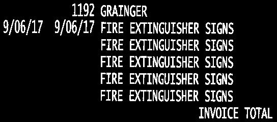
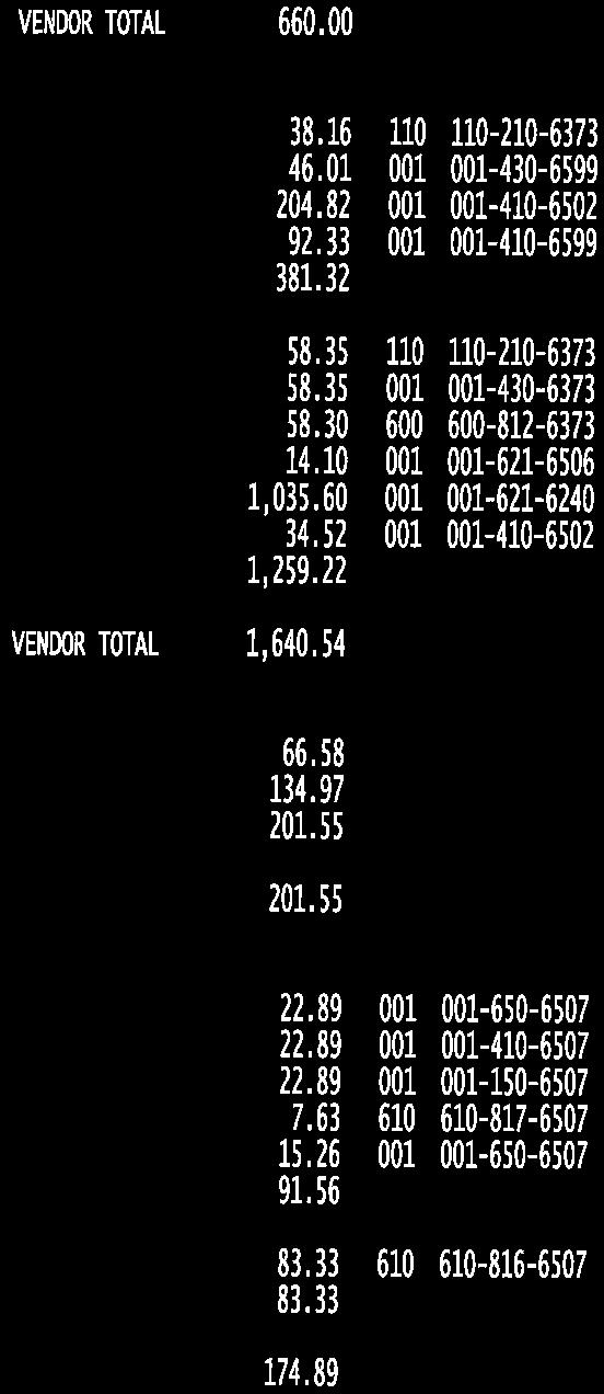
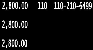
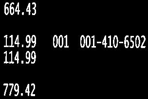
19 Tax Abatement Applications September 5, 2017 City of Bondurant Name Address Completion Date Cost Danna Robinson Saathoff th Street, Northeast August 22, 2017 $280, Luke Ullestad th Street, Southwest August 24, 2017 $212, Mallory Dobbs 920 Mulberry Drive, Northwest August 31, 2017 $295, Brent Dalton 206 Tailfeather Drive, Northeast May 6, 2015 $241,800.00
20 License Application ( BB Applicant Name of Applicant: Altus Brewing Company LLC ) Name of Business (DBA): Reclaimed Rails Brewing Company Address of Premises: 101 Main Street SE City Bondurant County: Polk Zip: Business (515) Mailing 133 Paine Street SE City Bondurant State IA Zip: Contact Person Name Chandler Parsons Phone: (515) chandler@rrbrewco.com Classification Class B Beer (BB) (Includes Wine Coolers) Term:12 months Effective Date: 09/10/2017 Expiration Date: 09/09/2018 Privileges: Class B Beer (BB) (Includes Wine Coolers) Class C Native Wine Permit (On-Premise) Outdoor Service Sunday Sales Status of Business BusinessType: Limited Liability Company Corporate ID Number: Federal Employer ID Ownership Justin Cloke First Name: Justin Last Name: Cloke City: Bondurant State: Iowa Zip: Position: Brewer % of Ownership: 20.00% U.S. Citizen: Yes Chandler Parsons First Name: Chandler Last Name: Parsons City: Bondurant State: Iowa Zip: Position: Vice President % of Ownership: 23.50% U.S. Citizen: Yes Joshua Obrecht First Name: Joshua Last Name: Obrecht
21 City: Bondurant State: Iowa Zip: Position: Secretary % of Ownership: 23.50% U.S. Citizen: Yes Jeremy Boka First Name: Jeremy Last Name: Boka City: Altoona State: Iowa Zip: Position: President % of Ownership: 23.50% U.S. Citizen: Yes Insurance Company Information Insurance Company: West Bend Mutual Insurance Company Policy Effective Date: 09/10/2017 Policy Expiration 09/10/2018 Bond Effective Outdoor Service Effective Temp Transfer Effective Dram Cancel Date: Outdoor Service Expiration Temp Transfer Expiration Date:
22
23 BUSINESS OF THE CITY COUNCIL BONDURANT, IOWA AGENDA STATEMENT Item No. 6f For Meeting of ITEM TITLE: Consideration of Resolution No Approving Cash Transfer from Water Checking to Water Deposits Checking CONTACT PERSON: Lori Dunham, Finance Director SUMMARY EXPLANATION The City is in the process of completing its Fiscal Year 2017 audit. The auditors questioned the General Ledger account balance for Water Deposits Checking vs. the Utility Billing Deposits Report, the balance being larger in the Utility Deposit Report by $66, Finance Director Lori Dunham brought this same issue up in 2006 when the FY2006 audit was completed and the auditors set the amount for Water Checking cash account at that time. The discrepancy may have occurred in 1999 when the City started using Summit software and the utilities were set up. The City s current auditors have directed that funds should be transferred from the Water checking cash to the Water Deposit account to reconcile with the Utility Deposit Report. The attached resolution authorizes that transfer. X Resolution Ordinance Contract Other (Specify) Funding Source APPROVED FOR SUBMITTAL Water - Checking Lori Dunham Finance Director RECOMMENDATION: Approval for cash transfer allowing reconciliation between the General Ledger and Utility Billing.
24 CITY OF BONDURANT RESOLUTION NO RESOLUTION APPROVING CASH TRANSFER FROM WATER CHECKING TO WATER DEPOSITS CHECKING WHEREAS, the City of Bondurant is in the process of completing its Fiscal Year 2017 audit with auditors Faller, Kincheloe and Co., PLC; AND WHEREAS, the auditors recommended a cash transfer from the Water Checking Cash Account to the Water Deposits Checking Cash Account in the General Ledger, allowing reconciliation between the General Ledger and the Utility Billing Deposits Report. NOW, THEREFORE, BE IT RESOLVED, by the City Council of the City of Bondurant in session this 07th day of August, 2017, that it hereby gives approval to transfer, by journal entry, $66, from the Water Checking Cash Account to the Water Deposits Checking Cash Account Passed this 05 th day of September, 2017, By: Curt Sullivan, Mayor ATTEST: I, Shelby Hagan, City Clerk of Bondurant, hereby certify that at a meeting of the City Council held on the above date, among other proceedings the above was adopted. IN WITNESS WHEREOF, I have hereunto set my hand the day and year above written. Shelby Hagan, City Clerk Name Yay Nay Abstain Absent Lohse Peffer Enos Keeler Elrod
25
26
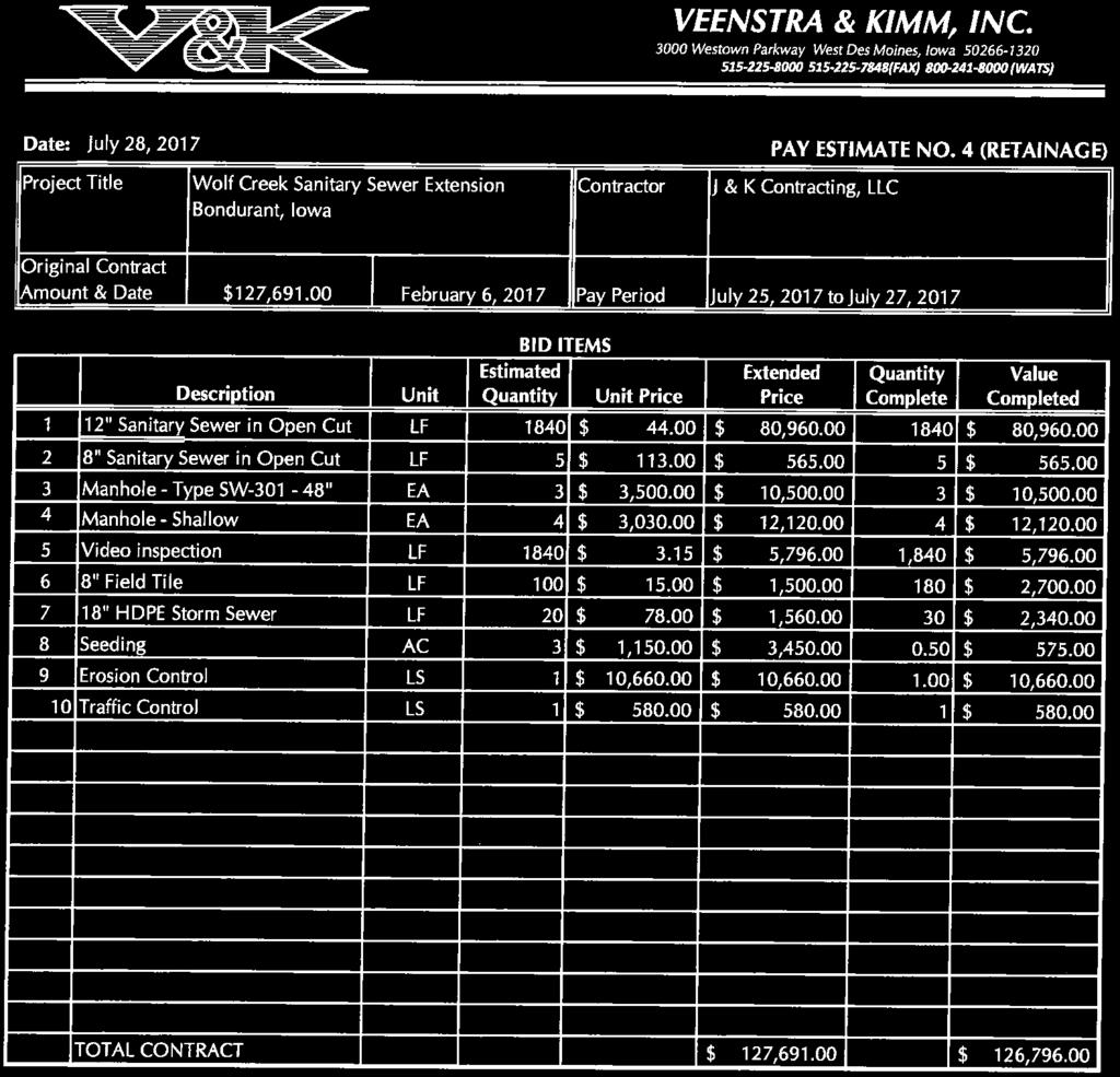
27 BUSINESS OF THE CITY COUNCIL BONDURANT, IOWA AGENDA STATEMENT Item No. 6g For Meeting of 9/5/17 ITEM TITLE: Resolution approving the Partial Payment Estimate No. 4 (Retainage) for the Wolf Creek Sanitary Sewer Extension CONTACT PERSON: Marketa Oliver, City Administrator SUMMARY EXPLANATION This resolution is concerning the final payment estimates and acceptance of work on the Wolf Creek Sanitary Sewer Extnesion project. It is requested J&K Contracting, LLC review Partial Payment Estimate No. 3 (Final) and Partial Payment Estimate No. 4 (Retainage). X Resolution Ordinance Contract Other (Specify) Funding Source NA APPROVED FOR SUBMITTAL City Administrator RECOMMENDATION: Approve resolution.
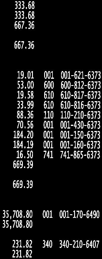
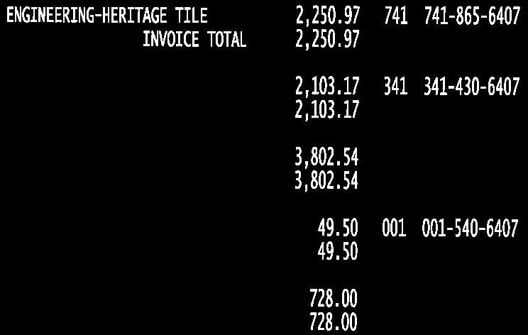
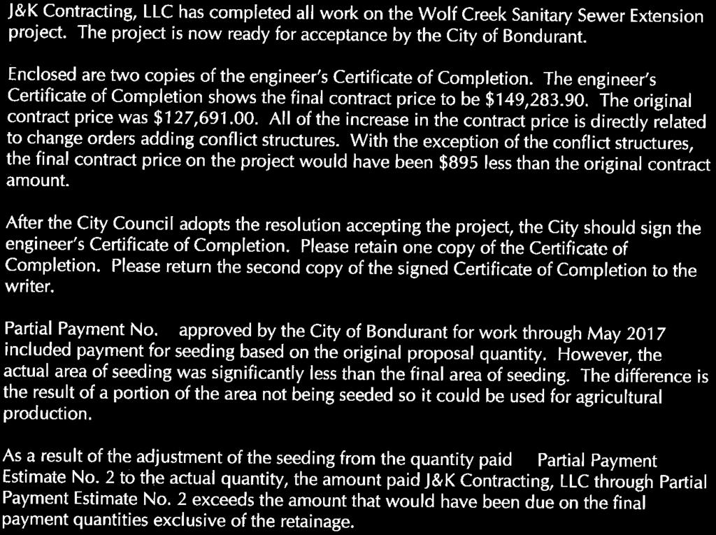
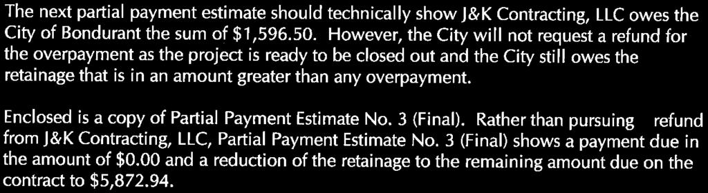
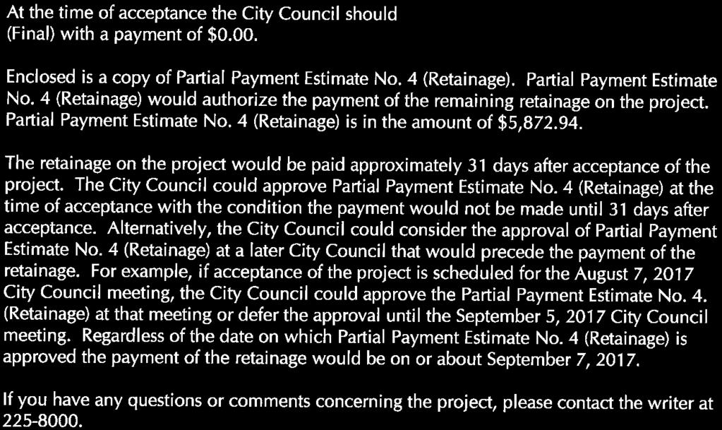
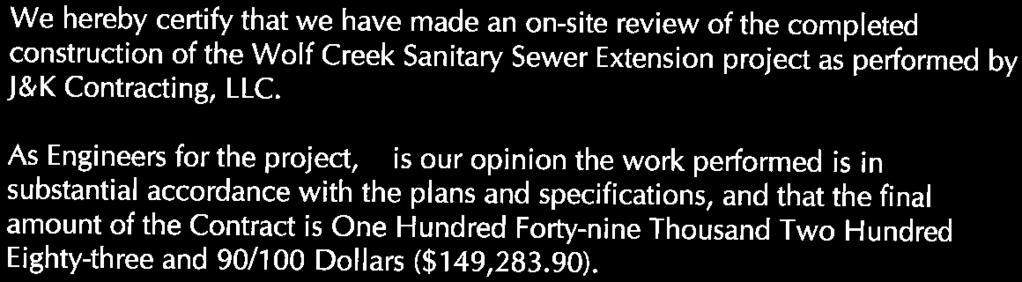
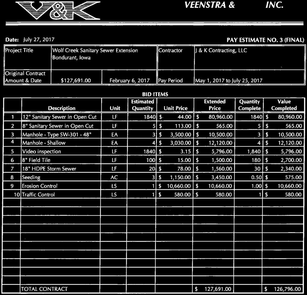
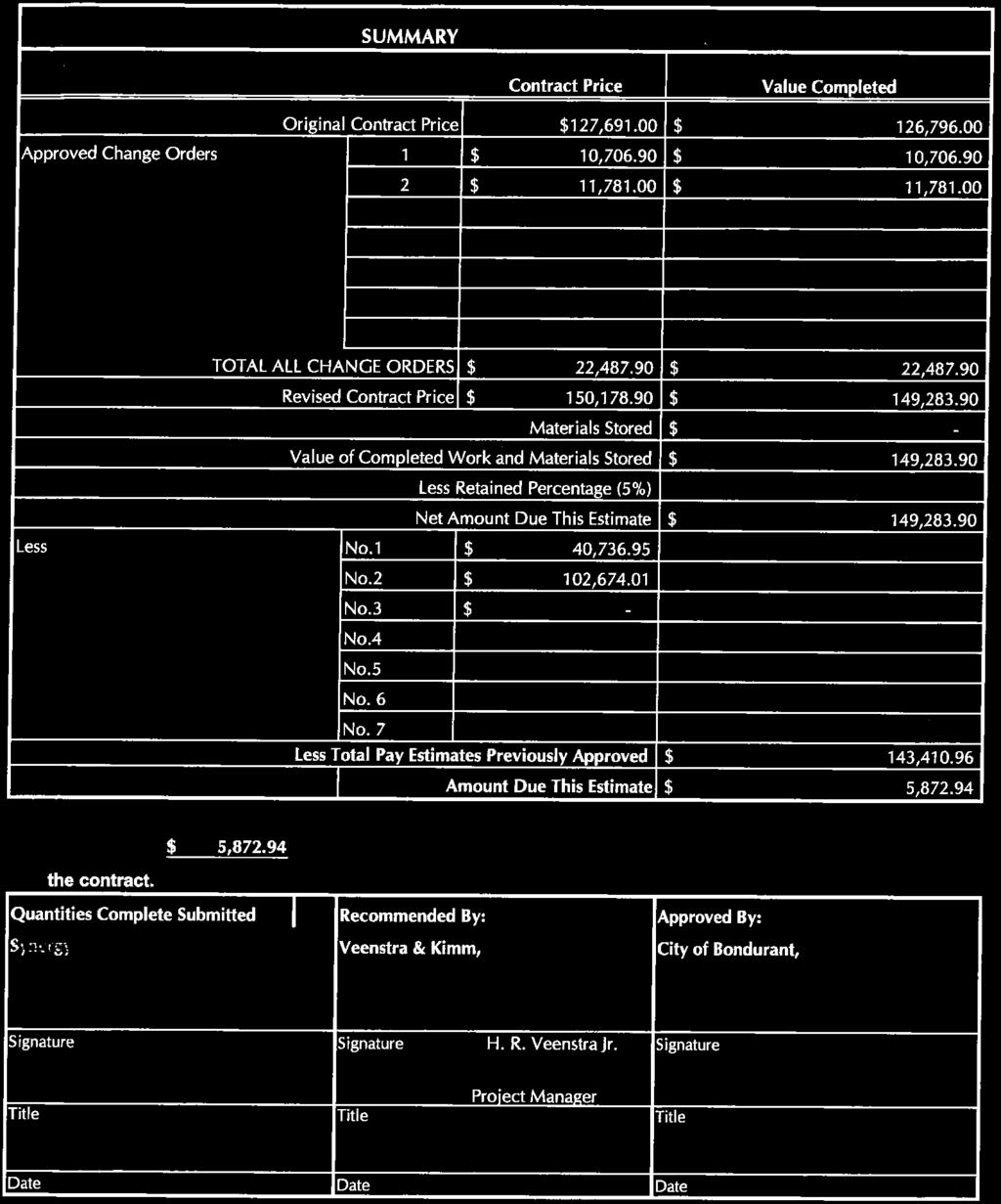
28 CITY OF BONDURANT RESOLUTION NO RESOLUTION APPROVING THE PARTIAL PAYMENT ESTIMATE NO. 4 (RETAINAGE) FOR THE WOLF CREEK SANITARY SEWER EXTENSION WHEREAS, J&K Contracting, LLC has completed all work on the Wolf Creek Sanitary Sewer Extension project; AND WHEREAS, the engineer s Certificate of Completion shows the final contract price to be $149,283.90; AND WHEREAS, the original contract price was $127,691.00; AND WHEREAS, Partial Payment No. 2 approved by the City of Bondurant for work through May 2017 included payment for seeding based on the original proposal quantity; AND WHEREAS, the actual area of seeding was significantly less than the final area of seeding; AND WHEREAS, as a result of the adjustment of the seeding from the quantity paid in Partial Payment Estimate No. 2 to the actual quantity, the amount paid J&K Contracting, LLC through Partial Payment Estimate No. 2 exceeds the amount that would have been due on the final payment quantities exclusive of the retainage; AND WHEREAS, the next partial payment estimate should technically show J&K Contracting, LLC owes the City of Bondurant the sum of $1,596.50; AND WHEREAS, the City will not request a refund for the overpayment as the project is ready to be closed out and the City still owes the retainage that is in an amount greater than any overpayment; AND WHEREAS, rather than pursuing a refund from J&K Contracting, LLC, Partial Payment Estimate No. 3 (Final) shows a payment due in the amount $0.00 and a reduction of the retainage to the amount due on the contract to $5,872.94; AND WHEREAS, the City Council should approve Partial Payment Estimate No. 4 (Retainage) with a payment of $5,872.94, NOW, THEREFORE, BE IT RESOLVED, by the City Council of the City of Bondurant, Iowa, that the Partial Payment No. 4 (Retainage) for the Wolf Creek Sanitary Sewer Extension project is hereby approved as presented. Passed this 5th day of September, 2017, By: Curt Sullivan, Mayor ATTEST: I, Shelby Hagan, City Clerk of Bondurant, hereby certify that at a meeting of the City Council held on the above date, among other proceedings the above was adopted. IN WITNESS WHEREOF, I have hereunto set my hand the day and year above written. Shelby Hagan, City Clerk
29 Council Action Lohse Peffer Enos Keeler Elrod Ayes Nays Abstain Absent


30


31


32


33

34
35


36
37

38


39
40 BUSINESS OF THE CITY COUNCIL BONDURANT, IOWA AGENDA STATEMENT Item No. 6h For Meeting of 9/5/17 ITEM TITLE: Resolution approving the Final Plat for Wolf Creek Plat 9 & 10 CONTACT PERSON: Marketa Oliver, City Administrator SUMMARY EXPLANATION This resolution is concerning the Final Plat for Wolf Creek Plat 9 & 10. X Resolution Ordinance Contract Other (Specify) Funding Source NA APPROVED FOR SUBMITTAL City Administrator RECOMMENDATION: Approve resolution.
41 CITY OF BONDURANT RESOLUTION NO RESOLUTION APPROVING THE FINAL PLAT FOR WOLF CREEK PLAT 9 & 10 WHEREAS, the owner/developer of the property is Chateau at Bondurant, LLC; AND WHEREAS, the surveyor of the property is Erin D. Griffin, Snyder & Associates, Inc.; AND WHEREAS, a part of the East ½ of the Northwest ¼ of Section 12, Township 79 North, Range 23 West of the 5 th P.M., City of Bondurant, Polk County, Iowa and more particularly described as follows: Beginning at the Northwest corner of Lot 1, Wolf Creek Plat 7, being an official, thence South East along the West line of said Lot 1, a distance of feet to the Southwest corner of said Lot 1; thence Westerly along the North line of street Lot A of said Wolf Creek Plat 7 and along a curve concave Southerly whose radius is feet, whose arc length is feet and whose chord bears South West, feet to the Northwest corner of said street Lot A ; thence South East along the West line of said street Lot A and the West line of Lot 12 of said Wolf Creek Plat 7, a distance of feet to the Southwest corner of said Lot 12; thence Westerly along a curve concave Southerly whose radius is feet, whose arc length is feet and whose chord bears South West, feet; thence Westerly along a curve concave Northerly whose radius is feet, whose arc length is feet and whose chord bears North West, feet; thence South West, feet; thence Southeasterly along a curve concave Northeasterly whose radius is feet, whose arc length is feet and whose chord bears South East, feet; thence South West, feet; thence Northwesterly along a curve concave Northeasterly whose radius is feet, whose arc length is feet and whose chord bears North West, feet; thence South West, feet to the West line of said East ½ of the Northwest ¼; thence North West along said West line, feet to the Northwest corner of said East ½ of the Northwest ¼; thence North East along the North line of said East ½ of the Northwest ¼, a distance of feet to the Northwest corner of Wolf Creek Plat 1, and official plat; thence South East along the West line of said Wolf Creek Plat 1, a distance of feet; thence Southerly continuing along said West line and along a curve concave Westerly whose radius is feet, whose arc length is feet and whose chord bears South West, feet to the Southwest corner of Lot 6 of said Wolf Creek Plat 1; thence South East along the South line of said Lot 6, a distance of feet to the Southeast corner of said Lot 6; thence Southerly along the Westerly line of said Wolf Creek Plat 1 and a curve concave Westerly whose radius is feet whose arc length is feet and whose chord bears South West, feet; thence South East continuing along said Westerly line, feet; thence Northerly continuing along said Westerly line and along a curve concave Easterly whose radius is feet, whose arc length is feet and whose chord bears North East, feet; thence South East continuing along said Westerly line, feet to the Northwest corner of Lot 56 of said Wolf Creek Plat 1; thence Southerly along the Westerly line of said Wolf Creek Plat 1 and Wolf Creek Plat 2, an Official Plat and a curve concave Westerly whose radius is feet, whose arc length is feet and whose chord bears South West, feet; thence Southwesterly
42 continuing along said Westerly line and along a curve concave Southeasterly whose radius is feet, whose arc length is feet and whose chord bears South East, feet to the Southerly line of said Wolf Creek Plat 2; thence Easterly along said Southerly line and along a curve concave Southerly whose radius is feet, whose arc length is feet and whose chord bears North East, feet to the point of beginning and containing acres (1,006,318 S.F.) being subject to 0.42 acres (18,345 S.F.) of roadway easement. Property subject to any and all easements of record. WHEREAS, a part of the East ½ of the Northwest ¼ and a part of the Southwest ¼ of the Northeast ¼ of Section 12, Township 79 North, Range 23 West of the 5 th P.M., City of Bondurant, Polk County, Iowa and more particularly described as follows: Beginning at the Southwest corner of the Northeast ¼ of the Northwest ¼; thence North West along the West line of said Northeast ¼ of the Northwest ¼, a distance of feet; thence North East, feet; thence Southerly along a curve concave Easterly whose radius is feet, whose arc length is feet and whose chord bears South East, feet; thence North East, feet; thence Northwesterly along a curve concave Northeasterly whose radius is feet, whose arc length is feet and whose chord bears North West, feet; thence North East, feet; thence Southeasterly along a curve concave Northeasterly whose radius is feet, whose arc length is feet and whose chord bears South East, feet; thence Easterly along a curve concave Southerly whose radius is feet, whose arc length is feet and whose chord bears North East, feet to the Northwest corner of Lot 1, Wolf Creek Plat 8, an Official Plat; thence South West along the West line of said Lot 1, a distance of feet to the South line of street Lot A of said Wolf Creek Plat 8; thence Easterly along said South line and along a curve concave Southerly whose radius is feet, whose arc length is feet and whose chord bears South East, feet to the Northwest corner of Outlot P of said Wolf Creek Plat 8; thence South West along the West line of said Outlot P, feet; thence South East continuing along said West line, feet to the Southwest corner of said Outlot P ; thence South West along the South line of the North feet of said Southwest ¼ of the Northeast 1/4, a distance of feet to the Southeast corner of the North feet of the Southeast ¼ of the Northwest ¼; thence South West along the South line of said North feet of the Southeast ¼ of the Northwest ¼, a distance of feet to the Southwest corner of said North feet of the Southeast ¼ of the Northwest ¼; thence North East along the West line of said Southeast ¼ of the Northwest ¼, a distance of feet to the point of beginning and containing acres (453,851 S.F.). Property subject to any and all easements of record. NOW, THEREFORE, BE IT RESOLVED, by the City Council of the City of Bondurant, Iowa, the Final Plat for Wolf Creek Plat 9 & 10 is hereby approved as presented. Passed this 5th day of September, 2017, By: Curt Sullivan, Mayor
43 ATTEST: I, Shelby Hagan, City Clerk of Bondurant, hereby certify that at a meeting of the city Council held on the above date, among other proceedings the above was adopted. IN WITNESS WHEREOF, I have hereunto set my hand the day and year above written. Shelby Hagan, City Clerk Name Yay Nay Abstain Absent Lohse Peffer Enos Keeler Elrod
44 'P 'M 1,167.85' Y:\pen\date.tbl V:\RefLibrary\CADDStandards\W orkspace\standards\printing\print_drivers\black_gray\v8ibw FulWeightPDF.pltcfg Snyder 1:50 8/22/ :27:27 AM JW MCCORMICK J:\2016_Projects\ \Cadd\ PLT9_FPT1.dgn LEGEND ' C45 Survey Found Set Section Corner 1/2" Rebar, Yellow Plastic Cap # (Unless Otherwise Noted) ROW Marker ROW Rail Control Point Bench Mark Platted Distance Measured Bearing & Distance Recorded As Deed Distance Yellow Plastic Cap Minimum Protection Elevation Centerline Section Line 1/4 Section Line 1/4 1/4 Section Line Easement Line CURVE TABLE CURVE NO. A1 A2 A3 A4 A5 A6 A7 A8 A9 A10 A11 A12 A13 A14 A15 A16 A17 A18 A19 A20 A21 A22 A23 A24 A25 A26 A27 A28 A29 A30 A31 A32 A33 A34 A35 A36 SW Corner NE1/4,NW1/4 Section Fnd 5/8" Rebar YPC #6807 1/2" Rebar, Yellow Plastic Cap # DELTA P M R D RADIUS CP YPC MPE ARC LENGTH MATCHLINE SHEET 2 TANGENT Pt. NE 1/4, NW 1/4 Sec Pt. SE 1/4, NW 1/4 Sec ' NOTES CHORD BEARING/DISTANCE ' ' ' ' ' ' 73.35' ' ' ' ' ' ' 7.82' 3.91' 7.82' ' 75.77' 38.05' 75.61' ' 84.74' 42.60' 84.51' ' 84.73' 42.59' 84.50' ' 75.77' 38.05' 75.61' ' 75.77' 38.05' 75.61' ' 17.44' 8.72' 17.43' ' 53.45' 26.84' 53.33' ' 59.77' 30.04' 59.61' ' 59.76' 30.04' 59.61' ' 53.45' 26.84' 53.34' ' 53.46' 26.84' 53.34' ' 12.26' 6.13' 12.25' ' 59.85' 29.98' 59.79' ' 49.69' 24.88' 49.66' ' 94.26' 47.36' 94.04' ' 47.13' 23.59' 47.10' ' 47.13' 23.59' 47.10' ' 55.55' 27.82' 55.51' ' 63.63' 31.88' 63.56' ' 63.63' 31.88' 63.56' ' 63.61' 31.87' 63.54' ' 47.52' 23.79' 47.49' ' 74.48' 37.31' 74.41' ' 95.49' 47.90' 95.34' ' 50.02' 25.03' 50.00' ' ' 51.59' ' ' 79.19' 39.68' 79.11' ' 79.19' 39.68' 79.11' ' 79.17' 39.67' 79.08' ' 59.15' 29.61' 59.11' ' 99.31' 49.82' 99.14' ' ' ' ' 10' Public OUTLOT Y 792,541 SF A27 Utility Easement A35 C AC 96.50' ' 11 6,481 SF A ' 30.00' A ' ' 7,967 SF A4 A18 A ' AL=25.01 OWNER/DEVELOPER CHATEAU AT BONDURANT, LLC 15 IONIA AVE SW, SUITE 340 GRAND RAPIDS, MI ZONING 20' Building Setback A38 A5 E1 5,039 SF STREET LOT B AL= ' 10 6,371 SF SEE NOTE 1 A20 A ' N30 42'53"E ' PUD - PLANNED UNIT DEVELOPMENT CURVE NO. A37 A38 A40 B1 B2 B3 B4 B5 B6 B8 B9 B10 B11 B12 B13 B14 B15 B16 B17 B18 B19 B20 B21 B22 B23 B24 B25 E1 E ' Rear Yard 10' Storm Sewer Easement A39 M&P A41 M&P A42 M A42 P A43 M A43 P B7 M&P C23 C SEE NOTE 1 Setback AL=41.99' DELTA 3609 WOLFCREEKRDSW 'Storm 73.85' AL=36.08' 58 A39 M&P PINE STREET A ' A6 A1 E2 A11 57 Sewer Easement RADIUS WOLF CREEK PLAT 2 9 7,124 SF SEE NOTE ,602 SF SEE NOTE 1 Easement A30 BK 12018, PG 789 A3 A22 A12 Utility Easement 5' Public 10' Storm Sewer ' 96.50' 8 7,122 SF SEE NOTE 1 A7 A ,891 SF SEE NOTE 1 A31 A37 BULK REGULATIONS MINIMUM LOT WIDTH = 65' FRONT YARD SETBACK = 20' REAR YARD SETBACK = 20' DATE OF SURVEY FEBRUARY 15, 2017 ARC LENGTH WOLF CREEK PLAT 9 A ' Storm Sewer Easement 01'Sotrm 98.56' Sewer Easement 96.50' TANGENT 7 6,368 SF SEE NOTE 1 A8 A14 STREET LOT A 45,723 SF A24 6,891 SF SEE NOTE ' 96.50' 6 6,366 SF A9 A A32 AREA SUMMARY 54 SW CORNER LOT 53 WOLF CREEK PLAT 2 FND 3/4" IRON ROD YPC# A15 20'Rear Yard Seb tack 98.52' 6,889 SF SEE NOTE ' ' ' ' ' ' ' ' ' ' ' ' 25.00' 37.14' 22.96' 33.82' ' 42.86' 21.44' 42.85' ' 42.87' 42.85' ' 97.44' 48.94' 97.22' 1,206.15' ' ' ' 1,236.15' 49.84' 24.92' 49.83' 1,236.15' 65.92' 32.97' 65.91' 1,236.15' 73.78' 36.90' 73.77' 1,236.15' 73.78' 36.90' 73.77' 1,236.15' 65.92' 32.97' 65.91' 1,236.15' 19.57' 9.79' 19.57' 1,334.65' 53.82' 26.92' 53.82' 1,334.65' 71.17' 35.59' 71.16' 1,334.65' 79.66' 39.84' 79.65' 1,334.65' 79.66' 39.84' 79.65' 1,334.65' 71.17' 35.59' 71.16' 1,176.15' 17.28' 8.64' 17.28' 1,176.15' 69.34' 34.68' 69.33' 1,176.15' 69.34' 34.68' 69.33' 1,176.15' 69.34' 34.68' 69.33' 1,176.15' 69.34' 34.68' 69.33' 1,079.65' 15.86' 7.93' 15.86' 1,079.65' 63.65' 31.83' 63.64' 1,079.65' 63.65' 31.83' 63.64' 1,079.65' 63.65' 31.83' 63.64' 1,079.65' 63.65' 31.83' 63.64' 1,334.65' ' ' ' 1,236.15' 46.35' 23.18' 46.34' 1,079.65' ' ' ' ' 34.24' 17.12' 34.23' ' ' ' ' 25.00' 36.28' 22.18' 33.18' 25.00' 36.28' 22.18' 33.18' FINAL PLAT A33 NE1/4 NW1/4 = 857,103SF ( 19.68AC) SE1/4 NW1/4 = 130,871SF ( 3.00AC) ROADWAY EASEMENT = 18,345SF (0.42AC) TOTAL = 1,006,318 SF ( 23.10AC) 1. THE MINIMUM PROTECTION ELEVATION FOR THIS LOT IS SHOWN ON THE APPROVED CONSTRUCTION PLANS BY THE LOCAL JURISDICTION. 2. THE USE OF A PUBLIC UTILITY EASEMENT IS SUBORDINATE TO THE CITY OF BONDURANT'S USE OF ITS DESIGNATED EASEMENT. ANY UTILITY UTILIZING THE PUBLIC UTILITY EASEMENT MUST RELOCATE AT NO COST WHEN THE SUBORDINATE USE IS IN CONFLICT WITH THE CITY OF BONDURANT'S USE OF ITS DESIGNATED EASEMENT THSTREETSW CHORD BEARING/DISTANCE A16 B8 B ' ,568 SF 'M&P 'M&P 'M&P 'M&P ' 97.44' 97.22' A10 A ' B2 6,746 SF A ' 20'Rear Yard Sebtack 4 6,752 SF SEE NOTE 1 B13 B14 B18 52 B ' 20' Building Setback 6,417 SF 96.50' PLAT DESCRIPTION EASEMENT. 0 Pt. NE 1/4, NW 1/4 Sec B10 B ' Public Utility & Drainage Easement 5' Public Utility Easement B23 7,558 SF SEE NOTE 1 B4 B1 19 6,417 SF B19B20 SCALE (FEET) ' 7' Gas Easement B15B16 20' Building Setback ' B ' Storm Sewer Easement 2 7,557 SF SEE NOTE 1 B5 7' Gas Easement 20 6,417 SF 10' Public Utility Easement WOLF CREEK PLAT 2 BK 12018, PG 789 B21 Pt. SE 1/4, NW 1/4 Sec PROPERTY SUBJECT TO ANY AND ALL EASEMENTS OF RECORD ' 98.50' 1 6,752 SF B B12 21 B6 6,417 SF B ' 30.00' 96.50' ERIN D. GRIFFIN LICENSED PROFESSIONAL LAND SURVEYOR IOWA ' M&P 98.50' M&P B7 M&P 1 2 SW CORNER LOT 1 WOLF CREEK PLAT 7 Street Lot "A" SW CORNER LOT 12 WOLF CREEK PLAT 7 5TH P.M., CITY OF BONDURANT, POLK COUNTY, IOWA AND MORE PARTICULARLY DESCRIBED AS FOLLOWS: FEET AND WHOSE CHORD BEARS SOUTH 78 21' 17" WEST, FEET; THENCE WESTERLY ALONG A CURVE BEARS NORTH 78 28' 16" WEST, FEET; THENCE SOUTH 41 52' 47" WEST, FEET; THENCE THE NORTHWEST 1/4; THENCE NORTH 89 11' 46" EAST ALONG THE NORTH LINE OF SAID EAST 1/2 OF THE FEET, WHOSE ARC LENGTH IS FEET AND WHOSE CHORD BEARS SOUTH 28 28' 46" WEST, FEET; EAST, FEET TO THE SOUTHERLY LINE OF SAID WOLF CREEK PLAT 2; THENCE EASTERLY ALONG SAID AND CONTAINING ACRES (1,006,318 S.F.) BEING SUBJECT TO 0.42 ACRES (18,345 S.F.) OF ROADWAY 20 POINT OF BEGINNING NW CORNER LOT 1 WOLF CREEK PLAT 7 5' Public Utility Easement WOLF CREEK PLAT 7 BK 16165, PG 806 A PART OF THE EAST 1/2 OF THE NORTHWEST 1/4 OF SECTION 12, TOWNSHIP 79 NORTH, RANGE 23 WEST OF THE BEGINNING AT THE NORTHWEST CORNER OF LOT 1, WOLF CREEK PLAT 7, BEING AN OFFICIAL PLAT; THENCE SOUTH 03 33' 41" EAST ALONG THE WEST LINE OF SAID LOT 1, A DISTANCE OF FEET TO THE SOUTHWEST CORNER OF SAID LOT 1; THENCE WESTERLY ALONG THE NORTH LINE OF STREET LOT "A" OF SAID WOLF CREEK PLAT 7 AND ALONG A CURVE CONCAVE SOUTHERLY WHOSE RADIUS IS FEET, WHOSE ARC LENGTH IS FEET AND WHOSE CHORD BEARS SOUTH 85 59' 06" WEST, FEET TO THE NORTHWEST CORNER OF SAID STREET LOT "A"; THENCE SOUTH 04 28' 07" EAST ALONG THE WEST LINE OF SAID STREET LOT "A" AND THE WEST LINE OF LOT 12 OF SAID WOLF CREEK PLAT 7, A DISTANCE OF FEET TO THE SOUTHWEST CORNER OF SAID LOT 12; THENCE WESTERLY ALONG A CURVE CONCAVE SOUTHERLY WHOSE RADIUS IS FEET, WHOSE ARC LENGTH IS CONCAVE NORTHERLY WHOSE RADIUS IS FEET, WHOSE ARC LENGTH IS FEET AND WHOSE CHORD SOUTHEASTERLY ALONG A CURVE CONCAVE NORTHEASTERLY WHOSE RADIUS IS FEET, WHOSE ARC LENGTH IS FEET AND WHOSE CHORD BEARS SOUTH 49 39' 28" EAST, FEET; THENCE SOUTH 38 48' 18" WEST, FEET;THENCE NORTHWESTERLY ALONG A CURVE CONCAVE NORTHEASTERLY WHOSE RADIUS IS FEET, WHOSE ARC LENGTH IS FEET AND WHOSE CHORD BEARS NORTH 33 26' 50" WEST, FEET; THENCE SOUTH 89 58' 40" WEST, FEET TO THE WEST LINE OF SAID EAST 1/2 OF THE NORTHWEST 1/4; THENCE NORTH 00 01' 20" WEST ALONG SAID WEST LINE, FEET TO THE NORTHWEST CORNER OF SAID EAST 1/2 OF NORTHWEST 1/4, A DISTANCE OF FEET TO THE NORTHWEST CORNER OF WOLF CREEK PLAT 1, AN OFFICIAL PLAT; THENCE SOUTH 00 40' 35" EAST ALONG THE WEST LINE OF SAID WOLF CREEK PLAT 1, A DISTANCE OF FEET; THENCE SOUTHERLY CONTINUING ALONG SAID WEST LINE AND ALONG A CURVE CONCAVE WESTERLY WHOSE RADIUS IS FEET, WHOSE ARC LENGTH IS FEET AND WHOSE CHORD BEARS SOUTH 06 01' 04" WEST, FEET TO THE SOUTHWEST CORNER OF LOT 6 OF SAID WOLF CREEK PLAT 1; THENCE SOUTH 77 17' 16" EAST ALONG THE SOUTH LINE OF SAID LOT 6, A DISTANCE OF FEET TO THE SOUTHEAST CORNER OF SAID LOT 6; THENCE SOUTHERLY ALONG THE WESTERLY LINE OF SAID WOLF CREEK PLAT 1 AND A CURVE CONCAVE WESTERLY WHOSE RADIUS IS FEET, WHOSE ARC LENGTH IS FEET AND WHOSE CHORD BEARS SOUTH 15 06' 13" WEST, FEET; THENCE SOUTH 72 30' 18" EAST CONTINUING ALONG SAID WESTERLY LINE, FEET; THENCE NORTHERLY CONTINUING ALONG SAID WESTERLY LINE AND ALONG A CURVE CONCAVE EASTERLY WHOSE RADIUS IS FEET, WHOSE ARC LENGTH IS FEET AND WHOSE CHORD BEARS NORTH 60 03' 03" EAST, FEET; THENCE SOUTH 77 23' 36" EAST CONTINUING ALONG SAID WESTERLY LINE, FEET TO THE NORTHWEST CORNER OF LOT 56 OF SAID WOLF CREEK PLAT 1; THENCE SOUTHERLY ALONG THE WESTERLY LINE OF SAID WOLF CREEK PLAT 1 AND WOLF CREEK PLAT 2, AN OFFICIAL PLAT AND A CURVE CONCAVE WESTERLY WHOSE RADIUS IS THENCE SOUTHWESTERLY CONTINUING ALONG SAID WESTERLY LINE AND ALONG A CURVE CONCAVE SOUTHEASTERLY WHOSE RADIUS IS FEET, WHOSE ARC LENGTH IS FEET AND WHOSE CHORD BEARS SOUTH 33 19' 42" SOUTHERLY LINE AND ALONG A CURVE CONCAVE SOUTHERLY WHOSE RADIUS IS FEET, WHOSE ARC LENGTH IS FEET AND WHOSE CHORD BEARS NORTH 78 48' 36" EAST, FEET TO THE POINT OF BEGINNING B24 NW CORNER STREET LOT A ' Public Utility Easement AREA ABOVE RESERVED FOR RECORDER'S STAMP INDEX LEGEND SURVEYOR'S NAME: ERIN D. GRIFFIN SNYDER & ASSOCIATES, INC SW SNYDER BOULEVARD ANKENY, IOWA EGRIFFIN@SNYDER-ASSOCIATES. COM SERVICE PROVIDED FOR: CHATEAU AT BONDURANT, LLC SURVEY LOCATED: RETURN TO: E1/2 OF THE NW1/4 OF SECTION 12-79N-23W REQUESTED BY: CHATEAU AT BONDURANT, LLC ERIN D. GRIFFIN SNYDER & ASSOCIATES, INC SW SNYDER BOULEVARD ANKENY, IOWA I hereby certify that this land surveying document was prepared and the related survey work was performed by me or under my direct personal supervision and that I am a duly licensed Professional Land Surveyor under the laws of the State of Iowa. Erin D. Griffin, PLS License Number My License Renewal Date is December 31, 2017 Pages or sheets covered by this seal: Date W OLF CREEK PLAT 9 1 REVISED AS PER CITY COMMENTS 08/17/17 JW M Project No: Sheet BY DATE REVISION MARK 1"= Scale: EDC Checked By: EDG Engineer: FINAL PLAT 1 50' BONDURANT, IA Technician: Date: Field Bk: Pg: JW M of 2727 S.W. SNYDER BLVD. Sheet 1 of ANKENY, IOW A Project No: S N Y D E R & A SSO CIA TES, IN C
45 'P 'M 1,167.85' Y:\pen\date.tbl V:\RefLibrary\CADDStandards\W orkspace\standards\printing\print_drivers\black_gray\v8ibw FulWeightPDF.pltcfg Snyder 1:50 8/22/ :27:50 AM NW Corner NE1/4 NW1/4 Sec Fnd Cut "X" Fnd 1/2" Rebar YPC # ' M&R STREET LOT B 18,345 SF Pt. NE 1/4, NW 1/4 Sec Existing OUTLOT Y 792,541 SF AC 33.0' Roadway Easement M&R Backslope Easement BK.8242 PG ' M&R Fnd 3/4" Pipe Fnd 3/4" Pipe YPC # ' M A43 M ' P 32ND STREET SW BK 11348, PG A43 P WOLF CREEK PLAT ' P 96.50' M A42 M A42 P Fnd 3/4" Iron Rod YPC #12972 A41 M&P 60.00'M 60.00'P W OLF CREEK ROAD SW 61 7 A40 WOLF CREEK PLAT 2 BK 12018, PG ' M Fnd Cut "X" 54 N. 1/4 Corner Sec Fnd Nail 8 33RD STREET SW 75.17' P WOLF CREEK PLAT 1 BK 11348, PG WOLF CREEK PLAT 1 BK 11348, PG NW CORNER LOT 56 Fnd 3/4" Pipe YPC # W OLF CREEK PLAT 9 1 REVISED AS PER CITY COMMENTS 08/17/17 JW M MARK REVISION DATE BY Scale: 1"= 50' Engineer: EDC Checked By: EDG BONDURANT, IA FINAL PLAT Technician: Date: Field Bk: Pg: JW M S.W. SNYDER BLVD. 2 Sheet 2 of ANKENY, IOW A Project No: S N Y D E R & A SSO CIA TES, IN C JW MCCORMICK J:\2016_Projects\ \Cadd\ PLT9_FPT_2.dgn MATCHLINE SHEET 1 A38 A SCALE (FEET) Project No: Sheet of 2
46 143.52' 'M 'P 96.00' Y:\pen\date.tbl V:\RefLibrary\CADDStandards\W orkspace\standards\printing\print_drivers\black_gray\v8ibw FulWeightPDF.pltcfg Snyder 1:50 8/22/ :29:15 AM JW MCCORMICK J:\2016_Projects\ \Cadd\ PLT10_FPT1.dgn 'R 30.00' 'M CURVE TABLE CURVE NO. C1 C2 C3 C4 C5 C6 C7 C8 C9 C10 C11 C12 C13 C14 C15 C16 C17 C18 C19 C20 C21 C22 C23 C24 C25 C26 C27 C28 C29 C30 C31 C32 C33 C34 C35 C36 C37 NW Corner NE1/4 NW1/4 Sec Fnd Cut "X" ' POINT OF BEGINNING SW CORNER NE1/4 NW1/4 Fnd 5/8" Rebar YPC # ' 65.00' 20.00' Pt. NE 1/4, NW 1/4 Sec ' DELTA 20.00' SW CORNER OF THE NORTH 425' SE1/4 NW1/4 SEC Fnd 5/8" Rebar YPC #6807 OUTLOT Z RADIUS 220,424 SF 5.06 AC 20' Storm Sewer Easement LEGEND Survey Found Set Section Corner 1/2" Rebar, Yellow Plastic Cap # (Unless Otherwise Noted) 1/2" Rebar, Yellow Plastic Cap#19710 ROW Marker ROW Rail Control Point Bench Mark Platted Distance Measured Bearing & Distance Recorded As Deed Distance Yellow Plastic Cap Minimum Protection Elevation Centerline Section Line 1/4 Section Line 1/4 1/4 Section Line Easement Line C45 NOTES ARC LENGTH TANGENT Pt. SE 1/4, NW 1/4 Sec ' Storm Sewer Easement 30' Sanitary Sewer Easement WOLF CREEK PLAT 9 TO BE RECORDED C ' 20.00' 96.00' C ' 27.04' 13 6,734 SF CHORD BEARING/DISTANCE ' ' ' ' ' ' 59.92' ' ' ' ' ' ' 62.29' 31.18' 62.26' ' ' 52.43' ' ' 52.29' 26.16' 52.27' ' 52.29' 26.16' 52.27' ' 72.02' 36.06' 71.98' ' 76.08' 38.09' 76.02' ' 76.08' 38.09' 76.02' ' 76.08' 38.09' 76.02' ' 76.08' 38.09' 76.02' ' 76.08' 38.09' 76.02' ' 3.68' 1.84' 3.68' ' 70.67' 35.40' 70.61' ' 78.80' 39.48' 78.71' ' 63.53' 31.81' 63.48' ' 63.53' 31.81' 63.48' ' 63.53' 31.81' 63.48' ' 63.53' 31.81' 63.48' ' 63.53' 31.81' 63.48' ' 3.07' 1.53' 3.07' ' 34.24' 17.12' 34.23' ' 65.23' 32.65' 65.21' ' 40.01' 20.01' 40.00' ' 65.25' 32.65' 65.22' ' 65.87' 32.97' 65.85' ' 65.87' 32.97' 65.85' ' 65.87' 32.97' 65.85' ' 65.87' 32.97' 65.85' ' 65.87' 32.97' 65.85' ' 65.87' 32.97' 65.85' ' 65.87' 32.97' 65.85' ' 10.07' 5.04' 10.07' ' 75.05' 37.56' 75.02' ' 75.07' 37.57' 75.04' ' 75.79' 37.93' 75.75' 5' Public Utility Easement 25.00' 25.00' ' THE CITY OF BONDURANT'S USE OF ITS DESIGNATED EASEMENT. A ' 50.02' 25.03' 50.00' P M R D CP YPC MPE C ' C4 C ' 12 7,613 SF SEE NOTE 1 AL=20.00' 10' Storm Sewer Easement AL=20.00' C ' C ' 6,735 SF SEE NOTE 1 C36 nig 20'Budli E3 C6 CURVE NO. C38 C39 C40 C41 C42 C43 C44 C45 C46 C47 D1 D2 D3 D4 D5 D6 D7 D8 D9 D10 D11 D12 D13 D14 D15 D16 D17 D18 D20 D21 D22 D23 D24 D25 D26 E3 E4 C ' Setback AL=41.99' C26 5,169 SF 97.00' STREET LOT B C7 AL=25.01 AL=25.01 E4 C ' PINE STREET 96.00' C37 DELTA 70.41' 15 6,800 SF 11 8,479 SF SEE NOTE 1 C8 C27 AL=36.08' 96.00' C16 10' Storm Sewer Easement 16 RADIUS 97.00' C28 6,800 SF C ,771 SF SEE NOTE 1 01'Sotrm C9 WOLF CREEK PLAT ' C17 1,303.43'M UTILIZING THE PUBLIC UTILITY EASEMENT MUST RELOCATE AT NO COST WHEN THE SUBORDINATE USE IS IN CONFLICT WITH 3635 LNIDENDRSW ' Public Utility Easement C ' Sewer Easement 17 C29 6,800 SF 1. THE MINIMUM PROTECTION ELEVATION FOR THIS LOT IS SHOWN ON THE APPROVED CONSTRUCTION PLANS BY THE LOCAL JURISDICTION. 2. THE USE OF A PUBLIC UTILITY EASEMENT IS SUBORDINATE TO THE CITY OF BONDURANT'S USE OF ITS DESIGNATED EASEMENT. ANY UTILITY D19M&P 1013 A C39 ARC LENGTH 9 C18 TANGENT 97.00' FINAL PLAT Pt. NE 1/4, NW 1/4 Sec Pt. SE 1/4, NW 1/4 Sec ,771 SF 6,771 SF SEE NOTE 1 6,771 SF SEE NOTE 1 SEE NOTE 1 C ' Public Utility Easement 1000 C ' C46 C ,800 SF C19 8 C C40 WOLF CREEK PLAT 9 TO BE RECORDED 912 STREET LOT A 49,176 SF 37THSTREETSW 97.00' C ,800 SF C41 C20 20'Rear Yard Sebtack CHORD BEARING/DISTANCE ' 75.79' 37.93' 75.75' ' 75.79' 37.93' 75.75' ' 75.79' 37.93' 75.75' ' 75.79' 37.93' 75.75' ' 75.79' 37.93' 75.75' ' 75.79' 37.93' 75.75' ' 11.59' 5.79' 11.59' ' ' ' ' ' ' ' ' ' ' ' ' ' ' ' ' ' 66.08' 33.05' 66.07' ' 69.55' 34.79' 69.54' ' 69.55' 34.79' 69.54' ' 69.55' 34.79' 69.54' ' 68.06' 34.04' 68.05' 1,079.65' 72.60' 36.32' 72.59' 1,079.65' 76.42' 38.23' 76.40' 1,079.65' 76.42' 38.23' 76.40' 1,079.65' 76.42' 38.23' 76.40' 1,079.65' 74.78' 37.40' 74.76' 1,079.65' ' 53.13' ' ' 59.85' 29.93' 59.84' ' 70.99' 35.51' 70.98' ' 71.01' 35.52' 71.00' ' 71.01' 35.52' 71.00' ' 76.45' 38.25' 76.43' ' 52.49' 26.25' 52.49' ' 23.96' 11.98' 23.96' ' 53.69' 26.85' 53.68' ' 63.69' 31.86' 63.67' ' 63.70' 31.87' 63.69' ' 63.70' 31.87' 63.69' ' 68.58' 34.31' 68.56' ' ' ' ' 1,079.65' ' ' ' 25.00' 41.49' 27.33' 36.89' 25.00' 41.49' 27.33' 36.89' 96.00' C ' C32 20'Rear Yard Sebtack ,800 SF C42 C21 6,771 SF 96.00' ' 25.00' 904 C13 OWNER/DEVELOPER CHATEAU AT BONDURANT, LLC 15 IONIA AVE SW, SUITE 340 GRAND RAPIDS, MI ZONING 97.00' C C ,800 SF C43 5 7,053 SF 96.00' PLAT DESCRIPTION AREA SUMMARY D7 D8 5' Public Utility Easement C14 D2 BULK REGULATIONS 97.00' C34 D ,489 SF C44 10' Public Utility Easement 7,080 SF 96.00' D20 NE1/4 NW1/4 = 19,192SF ( 0.44AC) SE1/4 NW1/4 = 417,022SF ( 9.57AC) SW1/4 NE1/4 = 17,637SF (0.40AC) TOTAL = 453,851SF ( 10.42AC) 4 D ' 20' Building Setback 23 6,465 SF D26 7,080 SF 96.00' D9 3 D4 D14 D15 20' Building Setback D21 D ' 7' Gas Easement 7' Gas Easement 24 6,466 SF 10' Public Utility Easement D22 D ' DATE OF SURVEY ERIN D. GRIFFIN LICENSED PROFESSIONAL LAND SURVEYOR IOWA 2 7,080 SF 6,466 SF WOLF CREEK PLAT 7 D10D11 D5 D ' 96.00' 1 6,928 SF D6 D ,303.43'R 59.40'M&P 00 BEGINNING AND CONTAINING ACRES (453,851 S.F.). PROPERTY SUBJECT TO ANY AND ALL EASEMENTS OF RECORD. D23 SE CORNER OF THE NORTH 425' SE1/4 NW1/4 SECTION FND 3/4" REBAR TO THE NORTHWEST CORNER OF LOT 1, WOLF CREEK PLAT 8, AN OFFICIAL PLAT; THENCE SOUTH 01 09' 58" WEST ALONG THE WEST LINE OF SAID LOT 1, A DISTANCE OF FEET TO THE SOUTH LINE OF STREET LOT "A" OF ALONG SAID WEST LINE, FEET TO THE SOUTHWEST CORNER OF SAID OUTLOT "P"; THENCE SOUTH 89 19' 50" WEST ALONG THE SOUTH LINE OF THE NORTH FEET OF SAID SOUTHWEST 1/4 OF THE NORTHEAST 1/4, A NORTHWEST 1/4; THENCE SOUTH 89 19' 54" WEST ALONG THE SOUTH LINE OF SAID NORTH FEET OF THE SOUTHEAST 1/4 OF THE NORTHWEST 1/4, A DISTANCE OF FEET TO THE SOUTHWEST CORNER OF SAID WEST LINE OF SAID SOUTHEAST 1/4 OF THE NORTHWEST 1/4, A DISTANCE OF FEET TO THE POINT OF 6,962 SF D 'M&P 25.00' 25.00' SW CORNER OUTLOT "P" A PART OF THE EAST 1/2 OF THE NORTHWEST 1/4 AND A PART OF THE SOUTHWEST 1/4 OF THE NORTHEAST 1/4 OF SECTION 12, TOWNSHIP 79 NORTH, RANGE 23 WEST OF THE 5TH P.M., CITY OF BONDURANT, POLK COUNTY, IOWA AND MORE PARTICULARLY DESCRIBED AS FOLLOWS: BEGINNING AT THE SOUTHWEST CORNER OF THE NORTHEAST 1/4 OF THE NORTHWEST 1/4; THENCE NORTH 00 01' 20" WEST ALONG THE WEST LINE OF SAID NORTHEAST 1/4 OF THE NORTHWEST 1/4, A DISTANCE OF FEET; THENCE NORTH 89 58' 40" EAST, FEET; THENCE SOUTHERLY ALONG A CURVE CONCAVE EASTERLY WHOSE RADIUS IS FEET, WHOSE ARC LENGTH IS FEET AND WHOSE CHORD BEARS SOUTH 33 26' 50" EAST, FEET; THENCE NORTH 38 48' 18" EAST, FEET; THENCE NORTHWESTERLY ALONG A CURVE CONCAVE NORTHEASTERLY WHOSE RADIUS IS FEET, WHOSE ARC LENGTH IS FEET AND WHOSE CHORD BEARS NORTH 49 39' 28" WEST, FEET; THENCE NORTH 41 52' 47" EAST, FEET; THENCE SOUTHEASTERLY ALONG A CURVE CONCAVE NORTHEASTERLY WHOSE RADIUS IS FEET, WHOSE ARC LENGTH IS FEET AND WHOSE CHORD BEARS SOUTH 78 28' 16" EAST, FEET; THENCE EASTERLY ALONG A CURVE CONCAVE SOUTHERLY WHOSE RADIUS IS FEET, WHOSE ARC LENGTH IS FEET AND WHOSE CHORD BEARS NORTH 81 10' 20" EAST, FEET SAID WOLF CREEK PLAT 8; THENCE EASTERLY ALONG SAID SOUTH LINE AND ALONG A CURVE CONCAVE SOUTHERLY WHOSE RADIUS IS FEET, WHOSE ARC LENGTH IS FEET AND WHOSE CHORD BEARS SOUTH 88 05' 52" EAST, FEET TO THE NORTHWEST CORNER OF OUTLOT "P" OF SAID WOLF CREEK PLAT 8; THENCE SOUTH 02 38' 17" WEST ALONG THE WEST LINE OF SAID OUTLOT "P", FEET; THENCE SOUTH 00 40' 10" EAST CONTINUING DISTANCE OF FEET TO THE SOUTHEAST CORNER OF THE NORTH FEET OF THE SOUTHEAST 1/4 OF THE NORTH FEET OF THE SOUTHEAST 1/4 OF THE NORTHWEST 1/4; THENCE NORTH 00 04' 50" EAST ALONG THE PUD - PLANNED UNIT DEVELOPMENT MINIMUM LOT WIDTH = 65' FRONT YARD SETBACK = 20' REAR YARD SETBACK = 20' FEBRUARY 15, 2017 AREA ABOVE RESERVED FOR RECORDER'S STAMP INDEX LEGEND SURVEYOR'S NAME: ERIN D. GRIFFIN SNYDER & ASSOCIATES, INC SW SNYDER BOULEVARD ANKENY, IOWA EGRIFFIN@SNYDER-ASSOCIATES. COM SERVICE PROVIDED FOR: CHATEAU AT BONDURANT, LLC SURVEY LOCATED: REQUESTED BY: CHATEAU AT BONDURANT, LLC RETURN TO: NW1/4 & NE1/4 SECTION 12-79N-23W ERIN D. GRIFFIN SNYDER & ASSOCIATES, INC SW SNYDER BOULEVARD ANKENY, IOWA laws of the State of Iowa. Erin D. Griffin, PLS License Number I hereby certify that this land surveying document was prepared and the related survey work was performed by me or under my direct personal supervision and that I am a duly licensed Professional Land Surveyor under the My License Renewal Date is December 31, 2017 Pages or sheets covered by this seal: 'M&P D19 M&P BK 16165, PG 'M&P 99.81'M&P NW CORNER LOT 1 SW CORNER LOT 1 WOLF CREEK PLAT 8 Street Lot "A" NW CORNER OUTLOT "P" 50 SCALE (FEET) OUTLOT P Date W OLF CREEK PLAT 10 1 REVISED AS PER CITY COMMENTS 08/17/17 JW M Project No: Sheet BY DATE REVISION MARK 1"= Scale: EDC Checked By: EDG Engineer: FINAL PLAT 1 50' BONDURANT, IA Technician: Date: Field Bk: Pg: JW M of 2727 S.W. SNYDER BLVD. Sheet 1 of ANKENY, IOW A Project No: S N Y D E R & A SSO CIA TES, IN C
47 BUSINESS OF THE CITY COUNCIL BONDURANT, IOWA AGENDA STATEMENT Item No. 9 For Meeting of ITEM TITLE: Consideration of second and/or third reading of Ordinance to Amend the City Code of the City of Bondurant, Iowa, by amending Chapter 69, Parking Regulations CONTACT PERSON: Marketa Oliver, City Administrator SUMMARY EXPLANATION: The attached ordinance amends the City s Code as it related to parking regulations in Plat 2 of Bluejay Landing. The first reading was adopted by Council on August 21 st. Resolution X Ordinance Contract Other (Specify) Funding Source NA APPROVED FOR SUBMITTAL City Administrator RECOMMENDATION: Approval of the parking regulations for Shiloh Rose Parkway.
48 CITY OF BONDURANT ORDINANCE NO ORDINANCE AMENDING THE CITY CODE OF THE CITY OF BONDURANT, IOWA, BY AMENDING CHAPTER 69 PARKING REGULATIONS BE IT ENACTED by the City Council of the City of Bondurant, Polk County, Iowa: Section 1. SECTION AMENDED. Chapter of the Code of Ordinances of the City of Bondurant, Iowa, 2002, is hereby amended to include the following: NO PARKING ZONES. No one shall stop, stand or park a vehicle in any of the following specifically designated no parking zones except when necessary to avoid conflict with other traffic or in compliance with the direction of a peace officer or traffic control signal. 109) Shiloh Rose Parkway, NW, from Mallard Pointe Drive, NW, to 2 nd Street, NW, west side of the street; Section 2. REPEALER. All ordinances or parts of ordinances in conflict with the provisions of this ordinance are hereby repealed. Section 3. SEVERABILITY. If any section, provisions, sentence, clause, phrase or part of this ordinance shall be adjudicated, invalid or unconstitutional, such adjudication shall not affect the validity of the ordinance as a whole or any provision, section, subsection, sentence clause, phrase or part thereof not adjudged invalid or unconstitutional. Section 4. EFFECTIVE DATE. This ordinance shall be in full force and effect following its passage, adoption and publication as required by law. Passed by the Council the day of 2017, and approved this day of CITY OF BONDURANT, POLK COUNTY, IOWA ATTEST: CURT SULLIVAN, MAYOR SHELBY HAGAN, CITY CLERK (SEAL) FIRST CONSIDERATION: August 21, 2017 SECOND CONSIDERATION: THIRD CONSIDERATION:
49
50 BUSINESS OF THE CITY COUNCIL BONDURANT, IOWA AGENDA STATEMENT Item No. 10 For Meeting of ITEM TITLE: Consideration of second and/or third reading(s) of to Amend the Bondurant Code of Ordinance, Concerning Sidewalk Maintenance Responsibility CONTACT PERSON: Marketa Oliver, City Administrator SUMMARY EXPLANATION: The attached ordinance amends the City s Code as it related to sidewalk maintenance responsibility. The change arises out of various court cases involving sidewalk maintenance. Guidance was offered through the Iowa League of Cities on how cities could update their ordinances to strengthen the City s position in the event of a sidewalk claim. The attached ordinance implements the recommended language to strengthen the City of Bondurant s code. The first reading was adopted on August 21 st, Resolution X Ordinance Contract Other (Specify) Funding Source NA APPROVED FOR SUBMITTAL City Administrator RECOMMENDATION:
51 CITY OF BONDURANT ORDINANCE NO AN ORDINANCE TO AMEND THE BONDURANT CODE OF ORDINANCES, CONCERNING SIDEWALK MAINTENANCE RESPONSIBLITY WHEREAS, the City of Bondurant has need on occasion to make language updates to various ordinances to ensure compliance with statutory of judicial changes; and WHEREAS, Chapter 136, Section 4 of the Bondurant Municipal Code currently contains language outlining sidewalk maintenance responsibility; and WHEREAS, the City wishes to revise the current language to ensure clarity and conformance with recent judicial guidance. BE IT THEREFORE ORDAINED by the City Council of the City of Bondurant: Section 1: Chapter 136 section 4 of the Bondurant Code of Ordinances is hereby struck in its entirety and replaced with the following language: RESPONSIBILITY FOR MAINTENANCE. The owner of any lot or parcel thereof abutting upon any sidewalk on the city streets in the city shall maintain said sidewalk in a state of good repair, free from cracks, holes, and unevenness so that the sidewalk does not constitute a safety hazard. A state of sidewalk disrepair is hereby declared a public nuisance. The owner of any lot or parcel who fails to repair said sidewalk shall be liable to any person injured as a result of such failure and shall further save, defend, indemnify, and hold harmless the city of Bondurant form an against any claim arising out of the failure to maintain said sidewalk. Section 2. Repealer. All ordinances or parts of ordinances in conflict with the provisions of the aforementioned ordinance(s) are hereby repealed. Section 3. Severability Clause. If any section, provision or part of this ordinance shall be adjudged invalid or unconstitutional, such adjudication shall not affect the validity of the ordinance as a whole or any section, provisions or part thereof not adjudged invalid or unconstitutional. Section 4. Effective Date. This ordinance shall be in effect from and after its final passage, approval and publication as provided by law. Passed by the Council the day of 2017, and approved this day of Attest: Curt Sullivan, Mayor Shelby Hagan, City Clerk FIRST CONSIDERATION: August 21, 2017 SECOND CONSIDERATION: THIRD CONSIDERATION:
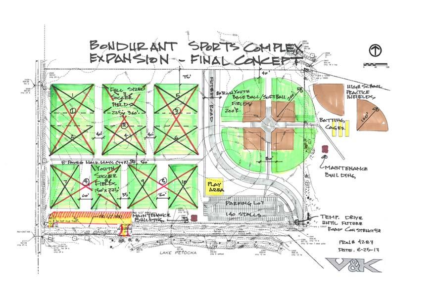
52 BUSINESS OF THE CITY COUNCIL BONDURANT, IOWA AGENDA STATEMENT Item No. 9 For Meeting of ITEM TITLE: Discussion and direction regarding the Bondurant Recreational Sports Complex Layout CONTACT PERSON: Marketa Oliver, City Administrator SUMMARY EXPLANATION: Attached is a copy of the draft layout for the expansion of the Bondurant Recreational Sports Complex. The City s engineer and staff met with representatives from the Soccer Club and Little League (Baseball and Softball) on Tuesday, August 1 st and the week of August 21 st regarding the 24 acre site north of Lake Petocka that the City recently purchased. The meeting with these representatives was focused on the number of fields at the 24 acre site and what types of fields would be accommodated. The attached concept arises from those discussion and past Council direction. The purpose of this discussion is to ensure that Council is comfortable with the layout. The layout serves as the foundation to determine how grading needs to be engineered. The goal is to prepare documents, secure quotes, and grade and seed the ground this fall. Resolution Ordinance Contract X Other (Specify) Discussion Funding Source TIF APPROVED FOR SUBMITTAL Finance Director RECOMMENDATION: Provide guidance needed to take additional steps to secure grading this fall.
53


54

55

56
CITY OF OCALA CITY COUNCIL REPORT Council Meeting Date: 06/06/17
 CITY OF OCALA CITY COUNCIL REPORT Council Meeting Date: 06/06/17 Subject: Large Scale Land Use Map Amendment Submitted By: David Boston Department: Growth Management STAFF RECOMMENDATION (Motion Ready):
CITY OF HIAWATHA, IOWA TOWN VILLAGE CENTER URBAN REVITALIZATION PLAN. for the TOWN VILLAGE CENTER URBAN REVITALIZATION AREA
 CITY OF HIAWATHA, IOWA TOWN VILLAGE CENTER URBAN REVITALIZATION PLAN for the TOWN VILLAGE CENTER URBAN REVITALIZATION AREA 2018 1 INTRODUCTION The Urban Revitalization Act, Chapter 404 of the Code of Iowa,
CERTIFIED SURVEY MAP
 SCONSIN STATE PLANE N:389676.12 E:2130390.15 Center of Section 23 CERTIFIED SURVEY MAP 734.06' THE (PRITCHETTE) ORIGINAL PLAT OF ALL IN THE NW 1 4 OF THE SE 1 4 OF FRACTIONAL SECTION 23, T7N, R9E, IN THE
COUNCIL AGENDA MEMO ITEM NO. III - #1
 COUNCIL AGENDA MEMO ITEM NO. III - #1 FROM: Anton Jelinek, Director of Utilities MEETING: October 24, 2017 SUBJECT: PRESENTER: Permanent Utility and Right-of-Way Easement Anton Jelinek Discussion: At the
VICINITY MAP SCALE 1'' = 2000'
 CITY CREEK ANNEXATION TO THE CITY OF THORNTON LOCATED IN THE SOUTHWEST QUARTER OF SECTION 11 AND THE WEST HALF OF SECTION 14, TOWNSHIP 1 SOUTH, RANGE 68 WEST OF THE 6TH PRINCIPAL MERIDIAN, COUNTY OF ADAMS,
ORDINANCE WHEREAS, the Planning and Zoning Board of the City of Belleview has been designated as the Local Planning Agency; and
 Page 1 of 9 ORDINANCE 2019-03 AN ORDINANCE OF THE CITY OF BELLEVIEW, FLORIDA RELATING TO AN AMENDMENT OF 8.87 +/- ACRES OF LAND TO THE CITY OF BELLEVIEW COMPREHENSIVE PLAN; AMENDING THE FUTURE LAND USE
WATERFORD LANDING COMMUNITY DEVELOPMENT DISTRICT REGULAR MEETING AGENDA
 WATERFORD LANDING COMMUNITY DEVELOPMENT DISTRICT REGULAR MEETING AGENDA January 31, 2019 Waterford Landing Community Development District OFFICE OF THE DISTRICT MANAGER 2300 Glades Road, Suite 410W Boca
DU PAGE COUNTY ZONING BOARD OF APPEALS JACK T. KNUEPFER ADMINISTRATION BUILDING 421 NORTH COUNTY FARM ROAD, WHEATON, ILLINOIS 60187/
 DU PAGE COUNTY ZONING BOARD OF APPEALS JACK T. KNUEPFER ADMINISTRATION BUILDING 421 NORTH COUNTY FARM ROAD, WHEATON, ILLINOIS 60187/ 630-407-6700 M E M O R A N D U M TO: FROM: DuPage County Board DuPage
AGENDA UPDATE ECONOMIC DEVELOPMENT & FINANCE STANDING COMMITTEE MEETING MONDAY, AUGUST 10, 2015 III. COMMITTEE AGENDA
 AGENDA UPDATE ECONOMIC DEVELOPMENT & FINANCE STANDING COMMITTEE MEETING MONDAY, AUGUST 10, 2015 III. COMMITTEE AGENDA REVISED ITEM NO. 4 150217.ORDINANCE: VACATION VILLAGE AREAS 1 AND 2A Synopsis: A revised
WHEREAS, the Petition is in all ways in complete compliance with the provisions of the Act; and,
 ORDINANCE NO. 15,700 AN ORDINANCE continuing the Downtown Des Moines Self-Supported Municipal Improvement District pursuant to the provisions of Chapter 386, Code of Iowa; and providing for the continuation
The City Council of the City of Sulphur, Louisiana, met in special session at its
 July 12, 2018 The City Council of the City of Sulphur, Louisiana, met in special session at its regular meeting place in the Council Chambers, Sulphur, Louisiana, on July 12, 2018 at 5:00 p.m., after full
ORDINANCE NO. Z REZONING NO
 ORDINANCE NO. Z- 3960 REZONING NO. 2018-00014 AN ORDINANCE RELATING TO ZONING: AMENDING CERTAIN ZONING REGULATIONS SHOWN ON SHEET NO. 15 OF THE ZONING DISTRICT MAP INCORPORATED BY REFERENCE BY OVERLAND
ABBREVIATION LEGEND SITE INFORMATION:
 SITE INFORMATION: Current Zone: R-3 PUD, governed by Fox Hollow 2nd MDA Basis of Elevations: Northeast Corner of Section 13, T6S, R1W, S.L.B. & M Elevation: 4599.26 (Benchmark) ABBREVIATION LEGEND Owners:
BILL NO (Emergency Measure) ORDINANCE NO. 5072
 ORDINANCE NO. 5072") BILL NO. 5210 (Emergency Measure) ORDINANCE NO. 5072 AN ORDINANCE AUTHORIZING THE MAYOR TO EXECUTE WITH MICHELSON-HADLEY HEIGHTS DEVELOPMENT, LLC, A CONTRACT AND QUIT CLAIM DEED CONVEYING CERTAIN PROPERTIES
BILL NO. 5210 (Emergency Measure) ORDINANCE NO. 5072 AN ORDINANCE AUTHORIZING THE MAYOR TO EXECUTE WITH MICHELSON-HADLEY HEIGHTS DEVELOPMENT, LLC, A CONTRACT AND QUIT CLAIM DEED CONVEYING CERTAIN PROPERTIES
ORDINANCE NO AN ORDINANCE To Be Entitled:
 3808 AN ORDINANCE To Be Entitled: AN ORDINANCE OF THE CITY COUNCIL OF THE CITY OF FORT MYERS, FLORIDA, REZONING FROM COMMERCIAL GENERAL TO PLANNED UNIT DEVELOPMENT AND APPROVING THE DEVELOPMENT PLAN FOR
CHAPTER XIX ANNEXATION ARTICLE 1. ANNEXATION
 CHAPTER XIX ANNEXATION ARTICLE 1. ANNEXATION 19.0101 JABORSKY ADDITION: WHEREAS, The City of Belfield pursuant to Section 40-51.2-07 of the North Dakota Century Code has amended having passed a Resolution
There is no fiscal impact associated with this Individual Development Approval.
 CRP-06-01 R2/13-97500005 Citibank Temporary Drive-Through 700-998 South Federal Highway The Via Mizner property is approximately 6.8 acres in area and is situated on the north side of Camino Real, east
City Council Information Form
 City Council Information Form DATE: 08/13/2014 ASSIGNED STAFF: Robert McKay DEPARTMENT: Planning&Development TYPE OF FORM: Ordinances Form No.: 4490 APPROVALS: None ISSUE/REQUEST: AN ORDINANCE VACATING
LISA ANDERSON-OGILVIE, AICP DEPUTY COMMUNITY DEVELOPMENT DIRECTOR AND PLANNING ADMINISTRATOR
 FOR MEETING OF: December 12, 2018 CASE NO.: VUL18-01 TO: FROM: HEARINGS OFFICER LISA ANDERSON-OGILVIE, AICP DEPUTY COMMUNITY DEVELOPMENT DIRECTOR AND PLANNING ADMINISTRATOR SUBJECT: VALIDATION OF UNIT
ORDINANCE NO. CID-3087
 ORDINANCE NO. CID-3087 AN ORDINANCE MAKING FINDINGS AS TO THE NATURE AND ADVISABILITY OF CREATING A COMMUNITY IMPROVEMENT DISTRICT AT THE NORTHEAST CORNER OF 91 ST STREET AND METCALF AVENUE; CREATING SAID
RESOLUTION NO. BE IT RESOLVED BY THE COUNCIL OF THE CITY OF SAN JOSE THAT:
 RESOLUTION NO. A RESOLUTION OF THE COUNCIL OF THE CITY OF SAN JOSE SETTING A PUBLIC HEARING TO CONSIDER WHETHER TO CONDITIONALLY VACATE A 12,903 SQUARE FOOT PORTION OF OLD WEST JULIAN STREET BETWEEN NORTH
ORDINANCE NO (PROPOSED)
") ORDINANCE NO. 1604 (PROPOSED) AN ORDINANCE OF THE CITY OF COCOA BEACH, BREVARD COUNTY, FLORIDA; AMENDING THE OFFICIAL ZONING MAP OF THE CITY OF COCOA BEACH, BY CHANGING THE ZONING DESIGNATION ON TWO PARCELS
ORDINANCE NO. 1604 (PROPOSED) AN ORDINANCE OF THE CITY OF COCOA BEACH, BREVARD COUNTY, FLORIDA; AMENDING THE OFFICIAL ZONING MAP OF THE CITY OF COCOA BEACH, BY CHANGING THE ZONING DESIGNATION ON TWO PARCELS
ORDINANCE NO (PROPOSED)
") ORDINANCE NO. 1603 (PROPOSED) AN ORDINANCE OF THE CITY OF COCOA BEACH, BREVARD COUNTY, FLORIDA; AMENDING THE COCOA BEACH COMPREHENSIVE PLAN BY AMENDING THE FUTURE LAND USE MAP 2025 (FLUE 2) BY CHANGING
ORDINANCE NO. 1603 (PROPOSED) AN ORDINANCE OF THE CITY OF COCOA BEACH, BREVARD COUNTY, FLORIDA; AMENDING THE COCOA BEACH COMPREHENSIVE PLAN BY AMENDING THE FUTURE LAND USE MAP 2025 (FLUE 2) BY CHANGING
COUNCIL ACTION FORM VACATION AND CONVEYANCE OF APPLE PLACE AND PEACH LANE RIGHT-OF-WAY TO THE OLD ORCHARD/CREEKSIDE MOBILE HOME PARK
 ITEM # 21&22 DATE: 03-27-18 COUNCIL ACTION FORM SUBJECT: VACATION AND CONVEYANCE OF APPLE PLACE AND PEACH LANE RIGHT-OF-WAY TO THE OLD ORCHARD/CREEKSIDE MOBILE HOME PARK BACKGROUND: City of Ames staff
City Council Agenda Item #13_ Meeting of March 6, 2017
 City Council Agenda Item #13_ Meeting of March 6, 2017 Description Recommendation Resolution vacating a sump easement and drainage and utility easements located at 1555 Linner Road. Hold the public hearing
ORDINANCE N0.18-ll6. WHEREAS, City has prepared a Service Plan for said tract which is attached as Exhibit "A" to this ordinance; &
 c: 0 ORDINANCE N0.18-ll6 AN ORDINANCE ANNEXING THE HEREINAFTER DESCRIBED TERRITORY TO THE CITY OF FORT STOCKTON, PECOS COUNTY, TEXAS, AND EXTENDING THE BOUNDARY LIMITS OF SAID CITY SO AS TO INCLUDE SAID
Honorable Mayor Bill Agan and members of the Richland Hills City Council. Final Plat Richland Hills, Lots 1 & 2, Block 1 Brumlow Addition
 2B - 1 Memorandum To: From: Date: Subject: Honorable Mayor Bill Agan and members of the Richland Hills City Council Jason Moore, Assistant City Manager January 17, 2017 Final Plat Richland Hills, Lots
WHEREAS, the Petition was filed by PATRICK AND KIMBERLY SHULER for the vacation of plat on property described herein; and
 VP 15-0003 RESOLUTION 2-16 A RESOLUTION PROVIDING FOR THE VACATION OF PLAT FOR A PUBLIC UTILITY AND DRAINAGE EASEMENT UNDERLYING A PREVIOUSLY VACATED RIGHT-OF-WAY BEING A PART OF SW 28 PLACE ADJACENT TO
THE BOARD OF COUNTY COMMISSIONERS OF THE COUNTY OF CLARK, STATE OF NEV ADA, DOES HEREBY ORDAIN AS FOLLOWS:
 BILI,, NO., 6-6-18-2 SUMMARY - An ordinance to amend the official zoning map to reflect certain zone changes. - ORDINANCE NO. ------------- 4596 (of Clark County, Nevada) AN ORDINANCE TO AMEND THE OFFICIAL
Village of Mahomet. 503 E. Main Street - P.O. Box Mahomet, IL phone (217) fax (217)
 fax (217)") Village of Mahomet 503 E. Main Street - P.O. Box 259 - Mahomet, IL 61853-0259 phone (217) 586-4456 fax (217) 586-5696 www.mahomet.govoffice.com PLAN AND ZONING COMMISSION TUESDAY, April 5, 2016 7:00 P.M.
Village of Mahomet 503 E. Main Street - P.O. Box 259 - Mahomet, IL 61853-0259 phone (217) 586-4456 fax (217) 586-5696 www.mahomet.govoffice.com PLAN AND ZONING COMMISSION TUESDAY, April 5, 2016 7:00 P.M.
ATTACHMENT B GRANT DEED. This deed is in satisfaction of the Eminent Domain Action Case No. GRANT DEED
 GRANT DEED RECORDING REQUESTED BY AND WHEN RECORDED MAIL TO: County of Orange County Executive Office CEO Real Estate 333 W. Santa Ana Blvd. Bldg. 10 Santa Ana, California 92701 AND MAIL TAX STATEMENTS
RESOLUTION NO WHEREAS, William Parrott and Peggy Parrott, his wife ("Applicants"), the owners of
, the owners of") ". fcf 1 Resolution 595 Page 1 INSTR # 1696524 OR BK 1822 PG 717 RECORDED 9/3/23 11:12:41 AM MARSHA EWING CLERK OF MARTIN COUNTY FLORIDA RECORDED BY C Burkey RESOLUTION NO. 595 A RESOLUTION OF THE TOWN
". fcf 1 Resolution 595 Page 1 INSTR # 1696524 OR BK 1822 PG 717 RECORDED 9/3/23 11:12:41 AM MARSHA EWING CLERK OF MARTIN COUNTY FLORIDA RECORDED BY C Burkey RESOLUTION NO. 595 A RESOLUTION OF THE TOWN
Sketch & Legal Description of Mitigation Bank and Ingress/Egress Access Easements
 Appendix H: Sketch & Legal Description of Mitigation Bank and Ingress/Egress Access Easements Tippen Bay Wetland Mitigation Bank DeSoto County, Florida Prepared by: September, 2017 Original file
MONDAY, JULY 16, :00 P.M. * 4. Approve, as submitted, minutes of regular meeting held July 2, 2012.
 MONDAY, JULY 16, 2012 8:00 P.M. 1. Pledge of Allegiance led by Village Clerk Marlene Williams. 2. Call meeting to order and roll call. 3. Approve Consent Agenda. * 4. Approve, as submitted, minutes of
UNOPPOSED ORDER GRANTING RECEIVER'S MOTION TO APPROVE THE SALE OF REAL PROPERTY OWNED BY MAMC EMERALD CAY, LLC
 IN THE CIRCUIT COURT OF THE ELEVENTH JUDICIAL CIRCUIT IN AND FOR MIAMI-DADE COUNTY, FLORIDA STATE OF FLORIDA, OFFICE OF FINANCIAL REGULATION, Plaintiff, v. BERMAN MORTGAGE CORPORATION, a Florida corporation,
Oakland County Michigan Register of Deeds Plat Engineering, GIS, & Remonumentation Dept. Ph: (248) Fax (248)
 Fax (248)") Oakland County Michigan Register of Deeds Plat Engineering, GIS, & Remonumentation Dept. Ph: (248)-858-1447 Fax (248)-858-7466 Requirements Needed for Final Plat Approval No. General Requirements. 1 Routing
Oakland County Michigan Register of Deeds Plat Engineering, GIS, & Remonumentation Dept. Ph: (248)-858-1447 Fax (248)-858-7466 Requirements Needed for Final Plat Approval No. General Requirements. 1 Routing
BY BOARD OF COUNTY COMMISSIONERS
 BY BOARD OF COUNTY COMMISSIONERS ORDINANCE NO. AN ORDINANCE CREATING THE PLANTATION PALMS MUNICIPAL SERVICE BENEFIT UNIT; PROVIDING FOR BOUNDARIES; PROVIDING FOR LEVY OF NON AD-VALOREM SPECIAL ASSESSMENTS;
RESOLUTION NO
 RESOLUTION NO. 2009 233 A RESOLUTION OF THE CITY COUNCIL OF THE CITY OF ELK GROVE QUITCLAIMING A PORTION OF ABANDONED EAST STOCKTON BOULEVARD TO ELK GROVE V PARTNERS, LLC PURSUANT TO AN AGREEMENT WHEREAS,
CITY OF PORT ST LUCIE
 CITY OF PORT ST LUCIE COUNCIL AGENDA MEMORANDUM Agenda Item #: 11B Meeting Date: 5/22/17 TO: Mayor and City 1Council 2 VIA: Russ Blackburrit, ity Manager Patricia Roeblirg, P.E., Assistant City Manager
OFFICIAL SUMMARY OF AN ORDINANCE TO CONVEY CERTAIN RAMSEY COUNTY PARK AND OPEN SPACE LANDS TO THE CITY OF MAPLEWOOD.
 OFFICIAL SUMMARY OF AN ORDINANCE TO CONVEY CERTAIN RAMSEY COUNTY PARK AND OPEN SPACE LANDS TO THE CITY OF MAPLEWOOD. This ordinance authorizes the conveyance of park and open space land owned by Ramsey
As Introduced. 131st General Assembly Regular Session H. B. No
 131st General Assembly Regular Session H. B. No. 239 2015-2016 Representative Sears A B I L L To amend section 5120.092 and to enact section 5120.80 of the Revised Code to allow the Director of Budget
ORDINANCE NO AN ORDINANCE AMENDING THE URBANA ZONING MAP. (Rezoning Multiple Properties to B-4 / Plan Case No.
 Passed: March 05, 2018 Signed: March 06, 2018 ORDINANCE NO. 2018-03-019 AN ORDINANCE AMENDING THE URBANA ZONING MAP (Rezoning Multiple Properties to B-4 / Plan Case No. 2329-M-18) WHEREAS, the Urbana Zoning
MINNETONKA PLANNING COMMISSION October 26, Rear yard setback variance for a deck expansion at 5732 Kipling Avenue
 MINNETONKA PLANNING COMMISSION October 26, 2017 Brief Description Rear yard setback variance for a deck expansion at 5732 Kipling Avenue Recommendation Adopt the resolution approving the variance Background
DEED AND DEDICATION FOR PUBLIC RIGHT OF WAY
 TO : BOARD OF DIRECTORS FROM : GARY PLATT, EXEC. DIRECTOR BUSINESS AND OPERATIONS SUBJECT : CITY OF STANWOOD CONSTRUCTION EASEMENT AND RIGHT-OF-WAY DEDICATION DATE : MARCH 17, 2009 TYPE : ACTION NEEDED
CONVEYANCE - COMMONWEALTH PROPERTY IN THE BOROUGH OF EAST STROUDSBURG, MONROE COUNTY Act of Jul. 1, 2016, P.L., No. 65 Cl.
 CONVEYANCE - COMMONWEALTH PROPERTY IN THE BOROUGH OF EAST STROUDSBURG, MONROE COUNTY Act of Jul. 1, 2016, P.L., No. 65 Cl. 85 An Act Authorizing the Department of General Services, with the approval of
CITY OF VICTORIA Location Map
 CITY OF VICTORIA Location Map Map Date: 2/8/2019 ± 0 0.05 0.1 0.2 0.3 0.4 mi Hawks Pointe City of Victoria, Carver County GIS CITY OF VICTORIA COUNTY OF CARVER STATE OF MINNESOTA ORDINANCE NO. XX AN
CITY OF NORTHVILLE FINAL REPORT HISTORIC DISTRICT BOUNDARIES
 CITY OF NORTHVILLE FINAL REPORT HISTORIC DISTRICT BOUNDARIES 2007 Background: In 2003 the Historic District Commission (HDC) undertook the task of revising the Historic District Boundaries in an effort
SAMPLE DECLARATION OF VACATION OF EASEMENT/RIGHT OF WAY. of record in the Office of the Judge of Probate of Morgan County, Alabama in Plat
 SAMPLE DECLARATION OF VACATION OF EASEMENT/RIGHT OF WAY ) KNOW ALL MEN BY THESE PRESENTS, THAT: OWNER S NAME, owner of all of the property adjacent to that certain drainage, utilities, and telecommunications
AGENDA COLLETON COUNTY COUNCIL REGULAR MEETING TUESDAY, FEBRUARY 5, :00 P.M. COUNTY COUNCIL CHAMBERS, OLD JAIL BUILDING
 AGENDA COLLETON COUNTY COUNCIL REGULAR MEETING TUESDAY, FEBRUARY 5, 2013 6:00 P.M. COUNTY COUNCIL CHAMBERS, OLD JAIL BUILDING 1. Call to Order 2. Invocation 3. Present Colors and Lead Pledge of Allegiance-
City Council Agenda Item #13_ Meeting of October 10, 2016
 City Council Agenda Item #13_ Meeting of October 10, 2016 Brief Description Recommendation Resolution approving vacation of existing drainage and utility easements located at 4301 Highview Place and an
ORDINANCE 2014-_. WHEREAS, Santa Rosa Island of Escambia County is unique in both usage and geography; and,
 ORDINANCE 2014-_ AN ORDINANCE RELATING TO ESCAMBIA COUNTY, FLORIDA; AMENDING CHAPTER 42, ARTICLE III, SECTIONS 42-63 AND 42-67 OF THE CODE OF ORDINANCES; DEFINING THE CORE AREA OF SANTA ROSA ISLAND; MODIFYING
DRAINAGE AND UTILITY EASEMENT. That Bruce Conrad, a single adult, hereinafter referred to as Grantor for good and
 DRAINAGE AND UTILITY EASEMENT KNOW ALL PERSONS BY THESE PRESENTS: That Bruce Conrad, a single adult, hereinafter referred to as Grantor for good and valuable consideration, the receipt and sufficiency
CORPORATE SPECIAL WARRANTY DEED FOR RIGHT OF WAY
 CORPORATE SPECIAL WARRANTY DEED FOR RIGHT OF WAY THIS INDENTURE WITNESSETH that ELI LILLY AND COMPANY, an Indiana corporation, ( Grantor ), as a gift and for no other consideration, CONVEYS ANDSPECIALLY
PLANNING COMMISSION REPORT Non-Public Hearing Item
 PC Staff Report 09/21/2015 Item No. 2B - 1 PLANNING COMMISSION REPORT Non-Public Hearing Item PC Staff Report 09/212015 ITEM NO. 2B: FINAL PLAT FOR MORGAN ADDITION; 800 MONTEREY WAY (MKM) : Consider a
CITY COUNCIL SPECIAL MEETING
 City Council Special Meeting January 16, 2018 A G E N D A CITY COUNCIL SPECIAL MEETING TUESDAY, JANUARY 16, 2018, AT 5:30 P.M. CST COUNCIL CHAMBERS, CITY HALL BUILDING, 100 SOUTH MONROE STREET, EAGLE PASS,
REVIEWED BY: Administrator Counsel Program Mgr.: Tiffany Schaufler Board Committee Engineer Other
 Minnehaha Creek Watershed District REQUEST FOR BOARD ACTION MEETING DATE: May 11, 2017 TITLE: Authorization to Grant a Temporary Easement to the City of Minnetrista RESOLUTION NUMBER: 17-034 PREPARED BY:
CITY OF BELLEVIEW REGULAR COMMISSION MEETING AGENDA
 CITY OF BELLEVIEW REGULAR COMMISSION MEETING AGENDA BELLEVIEW CITY HALL Commission Room Mayor CHRISTINE K. DOBKOWSKI Seat 1 MICHAEL J. GOLDMAN Seat 2 GARY W. ERNST 1/15/2019 Seat 3 RONALD T. LIVSEY 6:00
GeoPoint 1403 E. 5th Avenue Tampa, Florida
 AIRPORT ROAD PINELAND P.R.D. SUBDIVISION - PHASE 1 DEDICATION: CERTIFICATE OF REVIEW BY SURVEYOR, CITY OF ORMOND BEACH DEDICATION: THIS IS TO CERTIFY THAT FORESTAR (USA) REAL ESTATE GROUP INC., A DELAWARE
RESOLUTION NO. RD:EEH:LCP
 RESOLUTION NO. A RESOLUTION OF THE COUNCIL OF THE CITY OF SAN JOSE CONDITIONALLY VACATING A PORTION OF MERIDIAN AVENUE, SOUTH OF FRUITDALE AVENUE, AND RESERVING A PUBLIC SERVICE EASEMENT OVER THE VACATED
property be rezoned from its classification of Planned Development-265( PD-265) District, Planned Development-
 District, Planned Development-") i ORDINANCE NO. 9952-2015 AN ORDINANCE OF THE CITY OF GRAND PRAIRIE, TEXAS, AMENDING THE ZONING ORDINANCE AND MAP BY SHOWING THE LOCATION, BOUNDARY, AND USE OF A CERTAIN PROPERTY GRANTING A ZONING CHANGE
i ORDINANCE NO. 9952-2015 AN ORDINANCE OF THE CITY OF GRAND PRAIRIE, TEXAS, AMENDING THE ZONING ORDINANCE AND MAP BY SHOWING THE LOCATION, BOUNDARY, AND USE OF A CERTAIN PROPERTY GRANTING A ZONING CHANGE
AVENIR COMMUNITY DEVELOPMENT DISTRICT CITY OF PALM BEACH GARDENS REGULAR BOARD MEETING JANUARY 24, :00 P.M.
 AVENIR COMMUNITY DEVELOPMENT DISTRICT CITY OF PALM BEACH GARDENS REGULAR BOARD MEETING JANUARY 24, 2019 12:00 P.M. Special District Services, Inc. The Oaks Center 2501A Burns Road Palm Beach Gardens, FL
to St. Louis County by deed recorded in Book 7954, Page 235 in the St. Louis County, Missouri
 Recommendation of Planning Commission BILL NO. 4032 ORDINANCE NO. 2015-3971 AN ORDINANCE ENACTING A CONDITIONAL USE PERMIT FOR AN ELECTRICAL SUBSTATION AT 11520 DORSETT ROAD Petition of Ameren Missouri)
CITY OF PAPILLION MAYOR AND CITY COUNCIL REPORT MAY 16, 2018 AGENDA
 CITY OF PAPILLION MAYOR AND CITY COUNCIL REPORT MAY 16, 2018 AGENDA Subject: Type: Submitted By: A request to vacate the Final Plat for Prairie Queen First Subdivision, a subdivision legally described
SUBDIVISION APPLICATION
 STAFF USE ONLY Date Submitted: Received by: Fee paid: Project # REQUIRED SUBMITTALS Application Fee: $600.00 (up to 5 lots) + $50.00 (per lot above 5) Publication Fee: $300.00 Mailing Fee: $6.00 per hearing
BYRON TOWNSHIP ZONING APPLICATION
 BYRON TOWNSHIP ZONING APPLICATION Phone: (616) 878-9104 * Fax: (616) 878-3980 * Website: www.byrontownship.org This application will not be accepted if incomplete. APPLICATION FOR & REQUIRED COPIES Private
VILLAGE OF ORLAND PARK
 14700 Ravinia Avenue Orland Park, IL 60462 www.orlandpark.org Ordinance No: File Number: 2016-0865 ORDINANCE REZONING CERTAIN REAL ESTATE FROM E-1 ESTATE RESIDENTIAL DISTRICT TO COR MIXED USE DISTRICT
ADMINISTRATIVE HEARING STAFF REPORT Country Club Acres Second Amended Subdivision Amendment PLNSUB E Parkway Avenue December 12, 2013
 ADMINISTRATIVE HEARING STAFF REPORT Country Club Acres Second Amended Subdivision Amendment PLNSUB2013-00925 2167 E Parkway Avenue December 12, 2013 Planning Division Department of Community & Economic
AGENDA ITEM G-2 Public Works
 AGENDA ITEM G-2 Public Works STAFF REPORT City Council Meeting Date: 2/23/2016 Staff Report Number: 16-035-CC Consent Calendar: Adopt a resolution accepting Easements and approving the abandonment of two
Brookwood. special work session meeting. Authorizing
 - 11/23/2009-11/30/2009 COUNCIL MEETING AGENDA DECEMBER 7, 2009 7:00 P.M. EXECUTIVE SESSION 7:30 P.M. REGULAR MEETING Authorizing PSA-Farr Authorizing Refund Brookwood 1. CALL TO ORDER 2. OPEN PUBLIC MEETING
CITY OF WACONIA RESOLUTION
 CITY OF WACONIA RESOLUTION 2014-212 TOWNSHIP OF LAKETOWN RESOLUTION~~- \0 JOINT RESOLUTION STIPULATING TO THE AMENDMENT OF ORDERLY ANNEXATION AGREEMENT NO. 76-47 AND TO THE ORDERLY ANNEXATION OF THE RYLAND
BOARD OF COUNTY COMMISSIONERS AGENDA ITEM SUMMARY
 4C1 BOARD OF COUNTY COMMISSIONERS AGENDA ITEM SUMMARY PLACEMENT: CONSENT PRESET: TITLE: THE FLORIDA DEPARTMENT OF TRANSPORTATION IS REQUESTING THAT THE COUNTY TRANSFER OWNERSHIP OF RIGHT-OF-WAY AND A PERPETUAL
Synergy Park Addition (Companion to item 3)
") Synergy Park Addition (Companion to item 3) Attachments: 1. Locator 2. Replat staff report 3. Replat W P G r es rg eo e s Bu hh wy Lot 6A 4.02-acres Lot 4C 13.02-acres Fran k Lots 4C and 6A, Block A Synergy
Synergy Park Addition (Companion to item 3) Attachments: 1. Locator 2. Replat staff report 3. Replat W P G r es rg eo e s Bu hh wy Lot 6A 4.02-acres Lot 4C 13.02-acres Fran k Lots 4C and 6A, Block A Synergy
MEMORANDUM. Mayor and City Council. Warren Hutmacher, City Manager. Date: February 11, 2013
 MEMORANDUM To: From: Mayor and City Council Warren Hutmacher, City Manager Date: February 11, 2013 Subject: Approval of an Intergovernmental agreement by and between the City of Dunwoody and DeKalb County
INTERGOVERNMENTAL AGREEMENT
 INTERGOVERNMENTAL AGREEMENT This Intergovernmental Agreement (this Agreement) is made and entered into as of December 1, 2010, by and between the VILLAGE OF BIG ROCK, an Illinois municipal corporation
LOCATION MAP: AERIAL PHOTOGRAPH, 2015:
 LOCATION MAP: AERIAL PHOTOGRAPH, 2015: ORDINANCE NO. AN ORDINANCE OF THE CITY OF BRYAN, TEXAS, AMENDING CHAPTER 130, ZONING, OF THE CITY OF BRYAN CODE OF ORDINANCES, BY CHANGING THE ZONING CLASSIFICATION
30.00 $11.00 $17.00 $10.00 $20.00 $
 RECORDING COVER SHEET (Please Print or Type) This cover sheet was prepared by the person presenting the instrument for recording. The information on this sheet is a reflection of the attached instrument
PLANNING COMMISSION SUBDIVISION PLAT APPLICATION
 PLANNING COMMISSION SUBDIVISION PLAT APPLICATION Economic Development Department 3468 North Fulton Avenue Hapeville, Georgia 30354 Phone - 404.669.8269 Fax 404.669.3302 Rev. 09/23/16 1 The following information
CONSENT ACTION BY THE BOARD OF DIRECTORS OF VENETO IN MIRAMAR CONDOMINIUM ASSOCIATION, INC.
 CONSENT ACTION BY THE BOARD OF DIRECTORS OF VENETO IN MIRAMAR CONDOMINIUM ASSOCIATION, INC. The undersigned, being all of the members of the Board of Directors of Veneto in Miramar Condominium Association,
RESOLUTION NO. R To Acquire Real Property Interests Required for the Operations and Maintenance Satellite Facility
 RESOLUTION NO. R2015-35 To Acquire Real Property Interests Required for the Operations and Maintenance Satellite Facility MEETING: DATE: TYPE OF ACTION: STAFF CONTACT: Capital Committee Board PROPOSED
TOWN OF LYONS, COLORADO ORDINANCE NO. 1017
 TOWN OF LYONS, COLORADO ORDINANCE NO. 1017 AN ORDINANCE OF THE BOARD OF TRUSTEES OF THE TOWN OF LYONS ANNEXING TO THE TOWN OF LYONS CERTAIN REAL PROPERTY OWNED BY THE TOWN OF LYONS WHEREAS, the Town of
AVENIR COMMUNITY DEVELOPMENT DISTRICT CITY OF PALM BEACH GARDENS SPECIAL BOARD MEETING JANUARY 11, :00 A.M.
 AVENIR COMMUNITY DEVELOPMENT DISTRICT CITY OF PALM BEACH GARDENS SPECIAL BOARD MEETING JANUARY 11, 2018 11:00 A.M. Special District Services, Inc. The Oaks Center 2501A Burns Road Palm Beach Gardens, FL
JOINT RESOLUTION OF THE CITY OF PORT JERVIS, ORANGE COUNTY, NEW YORK AND THE TOWN OF DEERPARK, ORANGE COUNTY, NEW YORK
 JOINT RESOLUTION OF THE CITY OF PORT JERVIS, ORANGE COUNTY, NEW YORK AND THE TOWN OF DEERPARK, ORANGE COUNTY, NEW YORK WHEREAS, the City of Port Jervis, in conjunction with the Town of Deerpark seeks to
E WASHINGTON COUNTY OREGON. Andy Back, Planning and Development Services Manager
 Exhibit A E WASHINGTON COUNTY OREGON August 8, 2016 To: From: Subject: Board of Commissioners Andy Back, Planning and Development Services Manager MINOR BOUNDARY CHANGE CASEFILE NOS. 16-029 LRP/BC - ANNEXATION
AITKIN COUNTY BOARD August 9, 2016
 The Aitkin County Board of Commissioners met this 9 th day of August, 2016 at 9:03 a.m. with the following members present: Board Chair J. Mark Wedel, Commissioners Don Niemi, Brian Napstad, and Anne Marcotte.
RESOLUTION NO. R
 RESOLUTION NO. R-2016-1832 RESOLUTION APPROVING ZONING APPLICATION ZV/DOAlR-2016-00660 (CONTROL NO. 1998-00089) a Requested Use APPLICATION OF 2860 Ranch House Road LLC, Scotts Gas LLC, Ranch House Prop
FILE OF THE CITY CLERK ADMINISTRATION ORDINANCE NO ADMINISTRATION BILL NO INTRODUCED NOVEMBER 24, 2009
 FILE OF THE CITY CLERK ADMINISTRATION ORDINANCE NO. 15-2009 ADMINISTRATION BILL NO. 15-2009 INTRODUCED NOVEMBER 24, 2009 ADOPTED BY COUNCIL DECEMBER 8, 2009 AN ORDINANCE PROVIDING FOR TAX EXEMPTION FOR
FINAL PLAT APPLICATION
 FINAL PLAT APPLICATION (Page 1 of 3) LEGAL OWNER(s): NAME: STREET ADDRESS OWNER(s): CITY, STATE, ZIP CODE: PHONE NUMBER: BILLING ADDRESS: NAME OF ENGINEER/SURVEYOR: Engineer/Surveyor Address, Phone: PROPERTY
PUD Ordinance - Cascade Lakes Plat #10 of 1995
 PUD Ordinance - Cascade Lakes Plat #10 of 1995 CASCADE CHARTER TOWNSHIP Ordinance #10 of 1995 AN ORDINANCE TO AMEND THE CASCADE CHARTER TOWNSHIP ZONING ORDINANCE AND ZONING MAP TO ESTABLISH THE CASCADE
Community Development Department Council Chambers, 7:30 PM, July 20, 2017
 STAFF REPORT 2017-25P: Subdivision Community Development Department Council Chambers, 7:30 PM, July 20, 2017 To: From: Re: Paul Luke, Chairman, Skokie Plan Commission Mike Voitik, Planning Technician 2017-25P:
APPLICATION PACKET LAND SPLIT OR COMBINATION REVIEW
 APPLICATION PACKET LAND SPLIT OR COMBINATION REVIEW COMMUNITY DEVELOPMENT DEPARTMENT CHARTER TOWNSHIP OF PLYMOUTH 9955 N. Haggerty Road Plymouth, MI 48170 Fees Revised 7/01/2012 APPLICATION PACKET LAND
In Rem Foreclosure of Tax Liens By Lafayette County For Tax Years
 In Rem Foreclosure of Tax Liens By Lafayette County For Tax Years 2007-2011 Properties owned by Lafayette County, WI Sealed Bid Auction Date: November 13, 2015 Sealed Bid Auction Time: 11:00 a.m. Sealed
AGENDA BASEHOR PLANNING COMMISSION February 13, :00 p.m. Basehor City Hall
 AGENDA BASEHOR PLANNING COMMISSION February 13, 2018 7:00 p.m. Basehor City Hall 1. Call to Order 2. Pledge of Allegiance and Roll Call 3. Approval of Minutes of the preceding meeting. a. Minutes of the
CITY OF PUNTA GORDA ORDINANCE NO.
 CITY OF PUNTA GORDA ORDINANCE NO. AN ORDINANCE OF THE CITY OF PUNTA GORDA, FLORIDA, REZONING PROPERTIES GENERALLY DESCRIBED AS 901, 1001, AND 1101 AQUI ESTA DRIVE, PUNTA GORDA, FLORIDA, AND MORE PARTICULARLY
Village of Palm Springs
 Village of Palm Springs Executive Brief AGENDA DATE: September 28, 2017 DEPARTMENT: Finance ITEM #16: Ordinance No. 2017-23 - (SECOND READING) Establish FY 2017-2018 Millage Rates - Operating & Debt Service
PLANNING BOARD FEBURARY 11, 2019
 MINUTES 7:30 PM PRESENT: T. Ciacciarelli ABSENT: C. Ely D. Haywood L. Frank S. McNicol M. Mathieu L. Riggio L. Voronin M. Syrnick K. Kocsis, Alt #2 S. Harris, Alt #1 D. Pierce, Attorney CALL TO ORDER The
DATE: May 16, Honorable Mayor City Council Members. Laura Holey, Planner
 DATE: May 16, 2015 TO: FROM: Honorable Mayor City Council Members Laura Holey, Planner AGENDA ITEM: 11 C. Vacation of Easement 821 Corporate Drive REQUIRED ACTION: The City Council is asked to conduct
EASEMENT AGREEMENT. WHEREAS, Hall Brothers owns certain real property located in Weber County, Utah ( Hall Brothers Property );
;") When Recorded Return to: Parcel No. EASEMENT AGREEMENT THIS EASEMENT AGREEMENT ( Agreement ) is entered into this day of, 2016 by and between VALLEY DREAMS PROPERTIES, LLC, a Utah limited liability company
When Recorded Return to: Parcel No. EASEMENT AGREEMENT THIS EASEMENT AGREEMENT ( Agreement ) is entered into this day of, 2016 by and between VALLEY DREAMS PROPERTIES, LLC, a Utah limited liability company
APPLICATION PACKET LAND SPLIT OR COMBINATION REVIEW
 APPLICATION PACKET LAND SPLIT OR COMBINATION REVIEW COMMUNITY DEVELOPMENT DEPARTMENT CHARTER TOWNSHIP OF PLYMOUTH 9955 N. Haggerty Road Plymouth, MI 48170 Fees Revised 9.13.2017 APPLICATION PACKET LAND
TWIN CREEKS NORTH COMMUNITY DEVELOPMENT DISTRICT REGULAR MEETING AGENDA
 TWIN CREEKS NORTH COMMUNITY DEVELOPMENT DISTRICT REGULAR MEETING AGENDA NOVEMBER 6, 2018 Twin Creeks North Community Development District OFFICE OF THE DISTRICT MANAGER 2300 Glades Road, Suite 410W Boca
The North 140 Feet of Lot 4, Block 6, Metcalf View Second Plat, a subdivision of land in the City of Overland Park, Johnson County, Kansas.
 NOTICE OF PUBLIC HEARING CITY PLANNING COMMISSION CITY OF OVERLAND PARK, KANSAS Notice is hereby given that the City Planning Commission of Overland Park, Kansas, will hold a public hearing Monday, June