CITY OF VICTORIA Location Map
|
|
|
- Emma Pope
- 5 years ago
- Views:
Transcription


1 CITY OF VICTORIA Location Map Map Date: 2/8/2019 ± mi Hawks Pointe City of Victoria, Carver County GIS
2
3
4 CITY OF VICTORIA COUNTY OF CARVER STATE OF MINNESOTA ORDINANCE NO. XX AN ORDINANCE AMENDING ORDINANCE NO. 393 LIMITING LAKE MINNETONKA ACCESS TO RIPARIAN LOTS BLOCK 1, LOT 8 AND LOT 9 OF HAWKS POINTE. THE CITY COUNCIL OF THE CITY OF VICTORIA ORDAINS: Section 1. Ordinance 393, is hereby amended be deleting the stricken language and adding the underlined language as follows: Section 2. Section 109 of the Victoria City Code, the City's official zoning ordinance, is hereby amended by rezoning all property within Hawks Pointe from LMR (Lake Minnetonka Residential District) to LMR and PUD (Planned Unit Development Overlay District) as described herein below: TRACT A, REGISTERED LAND SURVEY NO. 127, FILES OF REGISTRAR OF TITLES, CARVER COUNTY, MINNESOTA, AND, THAT PART OF GOVERNMENT LOT 3 AND THE SOUTHEAST QUARTER OF THE NORTHWEST QUARTER OF SECTION 1, TOWNSHIP 116 NORTH, RANGE 24 WEST OF THE 5TH PRINCIPAL MERIDIAN DESCRIBED AS FOLLOWS: COMMENCING AT THE SOUTHWEST CORNER OF SAID GOVERNMENT LOT 3; THENCE ON AN ASSUMED BEARING OF NORTH 3 DEGREES 21 MINUTES 00 SECONDS WEST, ALONG THE WEST LINE OF SAID GOVERNMENT LOT 3, A DISTANCE OF FEET, TO THE POINT OF BEGINNING OF THE LAND TO BE DESCRIBED; THENCE NORTH 37 DEGREES 22 MINUTES 00 SECONDS EAST A DISTANCE OF FEET; THENCE NORTH 56 DEGREES 10 MINUTES 00 SECONDS EAST A DISTANCE OF FEET; THENCE NORTH 53 DEGREES 42 MINUTES 00 SECONDS EAST A DISTANCE OF FEET; THENCE NORTH 67 DEGREES 26 MINUTES 00 SECONDS EAST A DISTANCE OF FEET; THENCE NORTH 61 DEGREES 45 MINUTES 00 SECONDS EAST A DISTANCE OF FEET; THENCE NORTH 14 DEGREES 56 MINUTES 00 SECONDS WEST A DISTANCE OF FEET; THENCE NORTH 29 DEGREES 59 MINUTES 00 SECONDS EAST A DISTANCE OF FEET; THENCE NORTH 62 DEGREES 27 MINUTES 00 SECONDS WEST ABOUT 110 FEET TO THE CENTERLINE OF A CREEK RUNNING SOUTHWESTERLY THROUGH SAID GOVERNMENT LOT 3 AND SAID SOUTHEAST QUARTER OF THE NORTHWEST QUARTER; THENCE SOUTHWESTERLY, ALONG THE CENTERLINE OF SAID CREEK TO THE CENTERLINE OF STATE HIGHWAY NO. 7 AS DESCRIBED IN BOOK V OF DECREES, PAGE 540; THENCE SOUTHEASTERLY, ALONG SAID CENTERLINE TO THE WEST LINE OF SAID GOVERNMENT LOT 3; THENCE NORTH 3 DEGREES 21 MINUTES 00 SECONDS WEST, ALONG SAID WEST LINE OF GOVERNMENT LOT 3, TO THE POINT OF BEGINNING. Ordinance XXX Draft Page 1 of 3
5 EXCEPTING THE FOLLOWING DESCRIBED PARCEL: ALL THAT PART OF GOVERNMENT LOT 3, SECTION 1, TOWNSHIP 116 NORTH, RANGE 24 WEST OF THE FIFTH PRINCIPAL MERIDIAN, LYING EASTERLY OF THE CENTER OF A CREEK WHICH RUNS GENERALLY IN A SOUTHWESTERLY AND NORTHEASTERLY DIRECTION ACROSS SAID GOVERNMENT LOT 3 AND WESTERLY OF THE FOLLOWING DESCRIBED LINE: BEGINNING AT A POINT BEARING NORTH 76 DEGREES WEST, 380 FEET FROM THE INTERSECTION OF THE SHORE OF LAKE MINNETONKA WITH THE EAST LINE OF SAID GOVERNMENT LOT 3; THENCE SOUTH 18 DEGREES 45 MINUTES WEST, FEET TO THE CENTER LINE OF SAID CREEK; THENCE SOUTH 61 DEGREES 42 MINUTES WEST, 199 FEET; THENCE SOUTH 20 DEGREES 33 MINUTES WEST, FEET; THENCE SOUTH 25 DEGREES 43 MINUTES WEST, FEET; THENCE SOUTH 55 DEGREES 04 MINUTES WEST FEET, THENCE SOUTH 72 DEGREES 10 MINUTES WEST, FEET; THENCE SOUTH 43 DEGREES 27 MINUTES WEST, FEET; THENCE SOUTH 51 DEGREES 04 MINUTES WEST, FEET; THENCE SOUTH 47 DEGREES 44 MINUTES WEST, TO THE CENTER LINE OF A ROAD KNOWN AS THE EXCELSIOR AND WATERTOWN ROAD (AS THE SAME EXISTED ON NOVEMBER 18, 1941) AND THERE TERMINATING. Section 3. The rezoning of this property incorporates the following PUD (Planned Unit Development) design standards: Hawks Pointe Zoning Standards a. Intent The purpose of this zone is to create a PUD for a single-family detached housing development. The use of the PUD zone is to allow for more flexible design standards while sustaining a higher quality and more sensitive proposal. The PUD requires that the development demonstrate a high quality of design compatible with surrounding land uses as well as preservation of desirable site characteristics, open space, and protection of sensitive environmental features while achieving guided densities not be efficiently addressed through traditional zoning. Except as modified by the Hawks Pointe PUD standards, the development shall comply with the requirements of the LMR- Lake Minnetonka Residential District and Shoreland Overlay District Provisions. b. Permitted Uses The permitted uses in this zone shall be single-family detached houses and their accessory uses. Access to Lake Minnetonka over Lot 8 and Lot 9 of Block 1, Hawks Pointe, shall be limited to the owners and lawful occupants of said lots. c. Lot Requirements and Setbacks Minimum Lot size: 18,000 square feet (non-riparian); 40,000 square feet (riparian). Minimum Lot Width: 100 feet Minimum Lot Depth: 180 feet Ordinance XXX Draft Page 2 of 3
6 The PUD ordinance requires setbacks from roadways and exterior property lines. Lots are expected to sustain a maximum impervious surface area with the PUD. The following table displays those setbacks and the impervious surface maximum: Setback Standards Front yard : thirty (30) feet Rear yard : thirty-five (35) feet Side yard : ten (10) feet Impervious Surface Coverage Maximum: 35% Section 4. The zoning map of the City of Victoria shall not be republished to show the aforesaid zoning, but the Clerk shall appropriately mark the zoning map on file in the Clerk's Office for the purpose of indicating the rezoning and PUD standards hereinabove provided for in this ordinance, and all of the notations, references, and other information shown thereon are hereby incorporated by reference and made a part of this ordinance. Section 5. This ordinance shall be effective immediately upon its passage and publication. This ordinance shall become effective upon its passage and publication in accordance with the law. Passed and adopted this 25 th day of February, 2019 by the Victoria City Council. ATTEST: Douglas Reeder, Interim City Manager Thomas C. Funk, Mayor Ordinance XXX Draft Page 3 of 3
7 HAWK S POINTE LAKE ACCESS
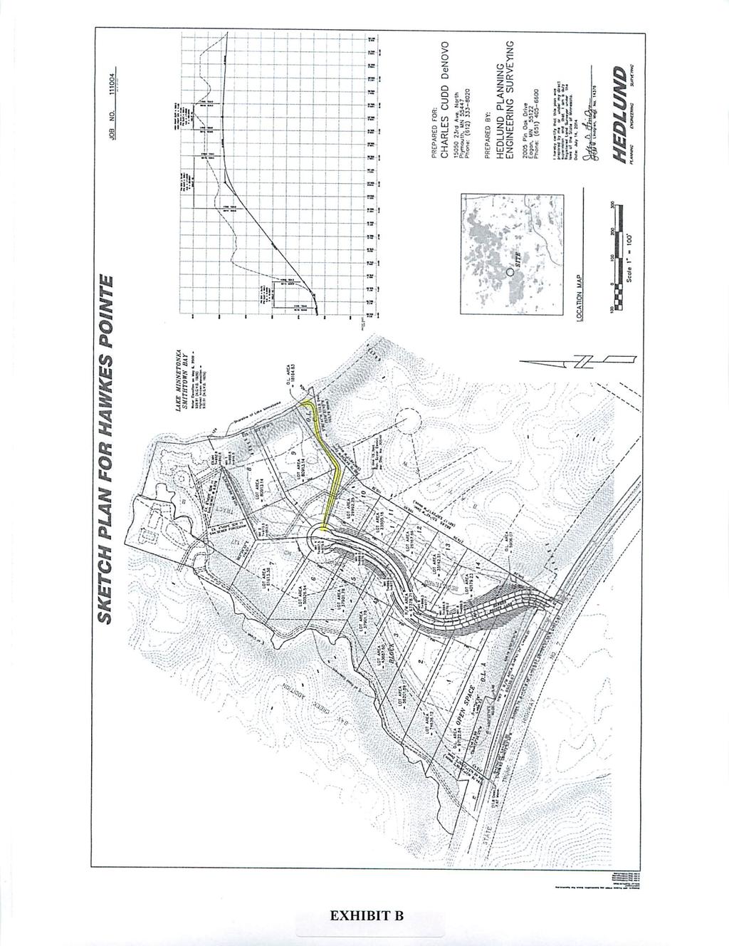
8 HAWKS POINTE ORIGINAL SKETCH PL AN 2014 Proposed access path on South of Lot 9 Plan was denied by City


9 PUBLIC HE ARING L A K E AC C E S S Presentation by City Representative (Ben Landhauser, Community Development Director) 15 lot development 2 lots with lake Any riparian lot on lake can have a dock. There is no common dock for the development Only two lots on Lake Minnetonka would be permitted to have docks No impact will be permitted to the Bluff Line Area.

10 RELEVANT INFO SEGMENTS OF RCA DOCUMENT Request for Council Action Meeting Date: August 24, 2015 Subject: Hawks Pointe Rezoning Staff Contact/Department: Ben Landhauser, Community Development Director Background: Hawks Pointe was originally presented to the City in 2014 with the intent to build 13 single family lots in conformance with the Lake Minnetonka Residential and Shoreland Overlay District provisions of the City Code. The density of the overall development was proposed at 1.3 units per acre, which fell below the minimum guided density of the property (1.5 units per acre) due to restrictions of the standard zoning ordinance requirements established in the Lake Minnetonka Residential and Shoreland Overlay District provisions. The City is required to review and approve development proposals that conform to the Comprehensive Plan. In such instances where standard zoning does not enable a development to achieve a minimum guided density, the City has a Planned Unit Development Overlay District that can be used to provide greater flexibility of standard zoning requirements in cases where a property has natural and/or physical restrictions that limit the efficient use of land as guided by the Comprehensive Plan.. With this in mind the applicant revised the development to achieve the minimum guided density of 1.5 units per acre with the addition of 2 more lots, for a total of 15 single family lots. As part of making the revision to 15 single family lots, it became necessary to rezone the property to include a Planned Unit Development Overlay. All PUDs are conditional uses in residential districts of the City, which requires approval of a conditional use permit as part of the property rezoning. Commission/Committee/Citizen Comments: The Victoria Planning Commission held a public hearing on the proposed Rezoning at the September 1, 2015 meeting and recommended approval: A. Hawks Pointe CUP, Rezoing, Preliminary Plat, and Final Plat 1) Agenda Statement ) Exhibits: Resolution 15-09, Preliminary Plat, Final Plat AGENDA STATEMENT: 15- Proposed Motions: Waive First Reading and Adopt Ordinance No. 393; Amending Section 30 by Rezoning all Property in Hawks Pointe from LMR (Lake Minnetonka Residential District) to LMR and PUD (Planned Development Overlay District); and Approve Resolution authorizing the Summary Publication of the Ordinance. Mr. Landhauser provided a description of the Hawks Pointe development. The development was originally proposed as 13 lots meeting the requirements of the Lake Minnetonka and Shoreland Overlay Districts. The current proposal includes 15 lots in order to meet the minimum guided density of 1.5 units per acre. The proposed lots are of a similar size to neighboring properties. A bluff line runs along the west side of the property and no impact will be permitted to the bluff. Outlot A and Outlot B will be dedicated to city. The PUD sets a hybrid standard between the Lake Minnetonka and Shoreland districts. The Commission questioned if it was possible to meet the minimum guided density and the Lake Minnetonka Overlays. Mr. Landhauser stated that it is not possible to meet both requirements. The Commission questioned if all exhibits have been received for the final plat and if the engineering department has reviewed the proposal. Mr. Landhauser stated that all necessary documents have been received and reviewed. The engineering department is comfortable with the proposals as the addition of the two lots have not changed the plans substantially. The Commission questioned the impervious surface maximum in the original proposal. Mr. Landhauser stated that the original proposal was 25% and the current proposal is 35% impervious surface. Further, due to the natural conditions of the site it is unlikely the lots will be able to reach 35% impervious surface coverage. Mr. Landhauser presented to the Commission two letters expressing concern for the proposal from property owners at 1150 Highway 7 and 6420 Thornberry Curve. The Commission discussed several of the concerns raised in the letters. The Commission questioned what authority the city has over docks on Lake Minnetonka, if there are any drainage concerns, the impact on the existing lift station capacity and if screening is planned between the proposed and existing developments. Mr. Landhauser stated that any riparian lot on Lake Minnetonka can have a dock. The city defers to the Lake Minnetonka Conservation Board to oversee permitting. All property owners on Lake Minnetonka are permitted four boats per dock. There is no common dock for the development, so only the two lots on Lake Minnetonka would be permitted to have docks. Mr. Landhauser stated the City Engineer does not have any concerns regarding drainage. There is an existing manhole and 8 inch gravity sewer anticipating subdivision of the property that is large enough to accommodate the proposed development. Mr. Landhauser stated that no grading will take place on the steep slopes adjoining the existing properties, allowing the existing wooded areas to be retained as screening. The Commission questioned the modifications to Highway 7. Mr. Landhauser stated that a turn lane will be added for access to the development. The Commission questioned impact on the creek located on the property. Mr. Landhauser stated that there will be no additional impact on creek. The high point changes and more storm water will drain to the storm water pond. This will allow for more infiltration prior to the water reaching the creek. The Commission questioned the review authority of the state archeologist office. Mr. Landhauser stated that it is not typical for the state archeologist office to do a review. Chair Donadio opened the public hearing at 6:51 p.m. Jon Malinski, 1150 Highway 7, stated that the creek overflowed two separate years, washing out the access driveway and sending water into some of the properties. He believes adding the hard surface area of two additional lots will cause further overflows. Mr. Malinski questioned if the ownership of the access driveway will change and he stated that the city has not maintained the access driveway as expected. Property owners have been adding rocks to prevent further wash outs of the access driveway. This access driveway is the only entry and exit point to his and neighboring properties. If the access driveway washes out, they are unable to come and go from their property. Mr. Malinski stated that the proposed storm water pond is not going to be sufficient based on the amount of water they have experienced in the last few years. Mr. Malinski requested copies of the grading and storm water plans and to discuss a maintenance agreement with the city for maintaining the access driveway in the event of a washout. Mr. Malinski further stated that getting out of the neighborhood onto Highway 7 is becoming more difficult and questioned the grade of the proposed road at the point of access to Highway 7. Mr. Landhauser stated there is an existing easement and that he will follow up on maintenance requirements of the city for the access driveway. The grade of the proposed access road to the new development is 9% with a landing at 5% before reaching Highway 7. Bob Kalla, 1200 Highway 7, stated that the sewer system sewer currently shuts off when there is a power outage, and as the lowest property he is concerned about sewer backups and the capacity of the lift station to handle an additional 15 homes. Mr. Kalla stated that the last couple years the creek overflowed onto the access driveway, resulting in a foot of water sitting over the road and debris clogging culverts. Mr. Kalla stated that he is concerned about adding more water runoff and contributing to erosion on the road. Arlene Malinski, 1150 Highway 7, stated that water coming over the road contributed to a traffic accident. Further, traffic limits the visibility on Highway 7 and questioned if there was a plan for a stoplight. She further questioned if boat access is only for the two lots on the lake and if that policy will change. Mr. Landhauser stated that no other lots will not have boat access. Cheryl Mach, 6510 Bayview Drive, stated that there will be a large impact on the woods and wildlife. The addition of the two lots to the development means her property now adjoins three lots, as opposed to two lots. Traffic makes it difficult to access Highway 7 and she is concerned about young drivers. Ms. Mach stated that the concerns of everyone should be taken into consideration. Further, the existing storm water pond on her property is currently at capacity. Mr. Landhauser stated that the pond is a development pond and not maintenance by the city. Further, the high point is property line so drainage from the proposed development will drain towards the street and not the existing pond. Trevor Minnie, 6560 Bayview Drive, stated that he will have a catchment pond in front of his property and is concerned about how the pond will be managed. Further, the traffic will make getting out of the property in the mornings difficult. Mr. Minnie requested copies of the landscape plan for the proposed development. Mr. Minnie also questioned if the development will clear the trees and replace them with smaller ones or retain the large trees. Mr. Landhauser stated that the intent is to keep as many trees as possible. The developer has a replacement requirement and the plan is to oversize the replacement trees to make up for the trees lost during construction and provide the development has a mature look. 6-B 6-B 6-B
11 APPROVED FINAL PLAT 15 lots 2 Riparian lots Utility Easement No access easement to lake The City did what they said they were going to do! KNOW ALL MEN BY THESE PRESENTS: Charles Cudd De Novo, LLC, a Minnesota limited liability company, owner of the following described property: Tract A, REGISTERED LAND SURVEY NO. 127, files of Registrar of Titles, Carver County, Minnesota, and, That part of Government Lot 3 and the Southeast Quarter of the Northwest Quarter of Section 1, Township 116 North, Range 24 West of the 5th Principal Meridian described as follows: Commencing at the southwest corner of said Government Lot 3; thence on an assumed bearing of North 3 degrees 21 minutes 00 seconds West, along the west line of said Government Lot 3, a distance of feet, to the point of beginning of the land to be described; thence North 37 degrees 22 minutes 00 seconds East a distance of feet; thence North 56 degrees 10 minutes 00 seconds East a distance of feet; thence North 53 degrees 42 minutes 00 seconds East a distance of feet; thence North 67 degrees 26 minutes 00 seconds East a distance of feet; thence North 61 degrees 45 minutes 00 seconds East a distance of feet; thence North 14 degrees 56 minutes 00 seconds West a distance of feet; thence North 29 degrees 59 minutes 00 seconds East a distance of feet; thence North 62 degrees 27 minutes 00 seconds West about 110 feet to the centerline of a creek running southwesterly through said Government Lot 3 and said Southeast Quarter of the Northwest Quarter; thence southwesterly, along the centerline of said creek to the centerline of State Highway No. 7 as described in Book V of Decrees, Page 540; thence southeasterly, along said centerline to the west line of said Government Lot 3; thence North 3 degrees 21 minutes 00 seconds West, along said West line of Government Lot 3, to the point of beginning. Excepting the following described parcel: All that part of Government Lot 3, Section 1, Township 116 North, Range 24 West of the Fifth Principal Meridian, lying easterly of the center of a creek which runs generally in a southwesterly and northeasterly direction across said Government Lot 3 and westerly of the following described line: Beginning at a point bearing North 76 degrees West, 380 feet from the intersection of the shore of Lake Minnetonka with the East line of said Government Lot 3; thence South 18 degrees 45 minutes West, feet to the center line of said creek; thence South 61 degrees 42 minutes West, 199 feet; thence South 20 degrees 33 minutes West, feet; thence South 25 degrees 43 minutes West, feet; thence South 55 degrees 04 minutes West feet, thence South 72 degrees 10 minutes West, feet; thence South 43 degrees 27 minutes West, feet; thence South 51 degrees 04 minutes West, feet; thence South 47 degrees 44 minutes West, to the center line of a road known as the Excelsior and Watertown Road (as the same existed on November 18, 1941) and there terminating. Has caused the same to be surveyed and platted as HAWKS POINTE and does hereby dedicate to the public for public use the public way and the drainage and utility easements as created by this plat. In witness whereof said Charles Cudd De Novo, LLC, a Minnesota limited liability company, has caused these presents to be signed by its proper officer this day of, 20. Signed: CHARLES CUDD DE NOVO, LLC, Chief Manager STATE OF MINNESOTA COUNTY OF This instrument was acknowledged before me on by, Chief Manager of Charles Cudd De Novo, LLC, a Minnesota limited liability company. Notary Public, Minnesota My Commission Expires I Eric B. Lindgren do hereby certify that this plat was prepared by me or under my direct supervision; that I am a duly Licensed Land Surveyor in the State of Minnesota; that this plat is a correct representation of the boundary survey; that all mathematical data and labels are correctly designated on this plat; that all monuments depicted on this plat have been, or will be correctly set within one year; that all water boundaries and wet lands, as defined in Minnesota Statutes, Section , Subd. 3, as of the date of this certificate are shown and labeled on this plat; and all public ways are shown and labeled on this plat. Dated this day of, 20 Eric B. Lindgren, Licensed Land Surveyor Minnesota License Number STATE OF MINNESOTA COUNTY OF DAKOTA This instrument was acknowledged before me on by Eric B. Lindgren. Notary Public, Minnesota My Commission Expires VICTORIA, MINNESOTA This plat of HAWKS POINTE was approved and accepted by the City Council of the City of Victoria, Minnesota at a regular meeting thereof held this day of, 20 and said plat is in compliance with the provisions of Minnesota Statutes, Section , Subdivision 2. All monuments will be set as specified by the City Council and as stated on this plat, according to Minnesota Statute, , Subd. 1. CITY COUNCIL, CITY OF VICTORIA, MINNESOTA By: Mayor By: Clerk COUNTY SURVEYOR, Carver County, Minnesota Pursuant to Chapter 395, Minnesota Laws of 1971, this plat has been approved this day of, 20. John E. Freemyer, Carver County Surveyor By: COUNTY AUDITOR/TREASURER, Carver County, Minnesota I hereby certify that taxes payable in and prior years have been paid for land described on this plat. Dated this day of, 20. Laurie Davies, County Auditor/Treasurer By: REGISTRAR OF TITLES, CARVER COUNTY, MINNESOTA I hereby certify that this plat of HAWKS POINTE was filed this day of, 20.at o'clock.m. as Document No.. Mark Lundgren, Registrar of Titles By:


12 PUBLIC HE ARING S E P T E M B E R 4 T H, Relevant Information Shared Access Easement Additional dock on Lot 8


13 OUR QUESTION F O R YO U Is City willing to listen to our concern? Before the Hearing, it appears builder/owner has started selling the shared lake access before approved. Realtor advertising (lake access) examples 1-2 Websites state Lake Access for homes that are not riparian lots example 3 Memo stated access for the neighbors EXAMPLE 3 EXAMPLE 1 EXAMPLE 2
AGENDA STATEMENT NO BUSINESS OF THE PLANNING COMMISSION City of Victoria, Minnesota STAFF REPORT. Casco Ventures (Developer)
") AGENDA STATEMENT NO. 17-1 BUSINESS OF THE PLANNING COMMISSION City of Victoria, Minnesota STAFF REPORT TO: Planning Commission PREPARED BY: Erin Smith, Senior Planner RE: Waterford Landing Project Rezoning
AGENDA STATEMENT NO. 17-1 BUSINESS OF THE PLANNING COMMISSION City of Victoria, Minnesota STAFF REPORT TO: Planning Commission PREPARED BY: Erin Smith, Senior Planner RE: Waterford Landing Project Rezoning
MINNETONKA PLANNING COMMISSION June 2, A conditional use permit for 2,328 square feet of accessory structures at 4915 Highland Road
 MINNETONKA PLANNING COMMISSION June 2, 2016 Brief Description A conditional use permit for 2,328 square feet of accessory structures at Recommendation Recommend the city council adopt the resolution approving
Resolution : A Resolution Recommending Approval Of Preliminary and Final Plats For Emma Krumbees Third Addition
 MEMORANDUM June 11, 2018 TO: FROM: SUBJECT: Planning Chairperson Carter Planning Commission Members Administrator Meyer Cynthia Smith Strack, Community Development Director Resolution 18 013: A Resolution
SUBDIVISION APPLICATION CHECKLIST SKETCH PLAN PRELIMINARY PLAT FINAL PLAT
 RECEIVED STAMP SUBDIVISION APPLICATION CHECKLIST SKETCH PLAN PRELIMINARY PLAT FINAL PLAT A checklist of background information and submission requirements for processing of a sketch plan, preliminary plat
ORDINANCE NO. Z REZONING NO
 ORDINANCE NO. Z- 3960 REZONING NO. 2018-00014 AN ORDINANCE RELATING TO ZONING: AMENDING CERTAIN ZONING REGULATIONS SHOWN ON SHEET NO. 15 OF THE ZONING DISTRICT MAP INCORPORATED BY REFERENCE BY OVERLAND
MINNETONKA PLANNING COMMISSION October 26, Rear yard setback variance for a deck expansion at 5732 Kipling Avenue
 MINNETONKA PLANNING COMMISSION October 26, 2017 Brief Description Rear yard setback variance for a deck expansion at 5732 Kipling Avenue Recommendation Adopt the resolution approving the variance Background
MAJOR RESIDENTIAL AND NONRESIDENTIAL SUBDIVISIONS
 MAJOR RESIDENTIAL AND NONRESIDENTIAL SUBDIVISIONS Final Plats The applicant shall schedule a Pre-Application meeting with Planning Staff at least seven (7) working days prior to submittal of the application.
ORDINANCE WHEREAS, the Planning and Zoning Board of the City of Belleview has been designated as the Local Planning Agency; and
 Page 1 of 9 ORDINANCE 2019-03 AN ORDINANCE OF THE CITY OF BELLEVIEW, FLORIDA RELATING TO AN AMENDMENT OF 8.87 +/- ACRES OF LAND TO THE CITY OF BELLEVIEW COMPREHENSIVE PLAN; AMENDING THE FUTURE LAND USE
CHAPTER XIX ANNEXATION ARTICLE 1. ANNEXATION
 CHAPTER XIX ANNEXATION ARTICLE 1. ANNEXATION 19.0101 JABORSKY ADDITION: WHEREAS, The City of Belfield pursuant to Section 40-51.2-07 of the North Dakota Century Code has amended having passed a Resolution
City Council Agenda Item #13_ Meeting of March 6, 2017
 City Council Agenda Item #13_ Meeting of March 6, 2017 Description Recommendation Resolution vacating a sump easement and drainage and utility easements located at 1555 Linner Road. Hold the public hearing
VILLAGE OF ORLAND PARK
 14700 Ravinia Avenue Orland Park, IL 60462 www.orlandpark.org Ordinance No: File Number: 2016-0865 ORDINANCE REZONING CERTAIN REAL ESTATE FROM E-1 ESTATE RESIDENTIAL DISTRICT TO COR MIXED USE DISTRICT
CHAPTER 26 PLANNING AND ZONING ARTICLE VII. MOBILE HOMES AND RECREATIONAL VEHICLE (RV) PARKS. Recreational Vehicle (RV) Park Development Standards
 PARKS. Recreational Vehicle (RV) Park Development Standards") CHAPTER 26 PLANNING AND ZONING ARTICLE VII. MOBILE HOMES AND RECREATIONAL VEHICLE (RV) PARKS. Section 26-VII-1. Section 26-VII-2. Section 26-VII-3. Section 26-VII-4. Section 26-VII-5. Purpose Permitted
CHAPTER 26 PLANNING AND ZONING ARTICLE VII. MOBILE HOMES AND RECREATIONAL VEHICLE (RV) PARKS. Section 26-VII-1. Section 26-VII-2. Section 26-VII-3. Section 26-VII-4. Section 26-VII-5. Purpose Permitted
To provide for the review of the final engineering plans, the subdivision improvement agreement, public dedications, and other legal agreements.
 ARTICLE 5 FINAL PLAT 501 Intent DOUGLAS COUNTY SUBDIVISION RESOLUTION To provide for the review of the final engineering plans, the subdivision improvement agreement, public dedications, and other legal
City of Brooklyn Park Planning Commission Staff Report
 City of Brooklyn Park Planning Commission Staff Report Agenda Item: 6D Meeting Date: August 9, 2017 Originating Agenda Section: Public Hearing Department: Community Development Resolution: X Ordinance:
REVIEWED BY: Administrator Counsel Program Mgr.: Tiffany Schaufler Board Committee Engineer Other
 Minnehaha Creek Watershed District REQUEST FOR BOARD ACTION MEETING DATE: May 11, 2017 TITLE: Authorization to Grant a Temporary Easement to the City of Minnetrista RESOLUTION NUMBER: 17-034 PREPARED BY:
I. Requirements for All Applications. C D W
 108-16.1. Application checklists. Checklist for Required Submissions to the Planning Board or Zoning Board of Adjustment of Monroe Township All required submissions are to be made to the Administrative
MINNETONKA PLANNING COMMISSION June 15, 2016
 MIETOKA PLAIG COMMISSIO June 15, 2016 Brief Description Ordinance rezoning a portion of the property at 4301 Highview Place and an adjacent unaddressed parcel from R-1 to R-1A Recommendation Recommend
FINAL SUBDIVISION AND LAND DEVELOPMENT PLAN CHECKLIST. Plan Name. Applicant's Name:
 TOWNSHIP OF UPPER ST. CLAIR FINAL SUBDIVISION AND LAND DEVELOPMENT PLAN CHECKLIST Date Filed Plan Name PLC Applicant's Name: Phone Filing Date for Final Application Final Plat 114.22. FINAL APPLICATION
ARTICLE 8C SITE CONDOMINIUM DEVELOPMENT ORDINANCE
 ARTICLE 8C SITE CONDOMINIUM DEVELOPMENT ORDINANCE SECTION 8C.01 PURPOSE It is the purpose of this Ordinance to insure that plans for development within Oceola Township proposed under the provisions of
WILTON MANORS, Island City 2020 WILTON DRIVE, WILTON MANORS, FLORIDA 33305
 WILTON MANORS, Island City 2020 WILTON DRIVE, WILTON MANORS, FLORIDA 33305 COMMUNITY DEVELOPMENT SERVICES (954) 390-2180 FAX: (954) 567-6069 PLAT APPLICATION PACKAGE This package includes: General Submittal
MAJOR RESIDENTIAL AND NONRESIDENTIAL SUBDIVISIONS
 Lawrence-Douglas County MAJOR RESIDENTIAL AND NONRESIDENTIAL SUBDIVISIONS Preliminary Plats The applicant shall schedule a Pre-Application meeting with Planning Staff at least seven (7) working days prior
SUBMITTAL REQUIREMENTS: The number indicates the number of copies for submittal (if applicable).
.") Office Use Only Preliminary Long Plat Long Subdivision Applicant Checklist PLANNING, COMMUNITY, & ECONOMIC DEVELOPMENT DEPARTMENT PRELIMINARY LONG PLAT LONG SUBDIVISION CHECKLIST Mailing Address: P.O.
Office Use Only Preliminary Long Plat Long Subdivision Applicant Checklist PLANNING, COMMUNITY, & ECONOMIC DEVELOPMENT DEPARTMENT PRELIMINARY LONG PLAT LONG SUBDIVISION CHECKLIST Mailing Address: P.O.
DU PAGE COUNTY ZONING BOARD OF APPEALS JACK T. KNUEPFER ADMINISTRATION BUILDING 421 NORTH COUNTY FARM ROAD, WHEATON, ILLINOIS 60187/
 DU PAGE COUNTY ZONING BOARD OF APPEALS JACK T. KNUEPFER ADMINISTRATION BUILDING 421 NORTH COUNTY FARM ROAD, WHEATON, ILLINOIS 60187/ 630-407-6700 M E M O R A N D U M TO: FROM: DuPage County Board DuPage
ABBREVIATION LEGEND SITE INFORMATION:
 SITE INFORMATION: Current Zone: R-3 PUD, governed by Fox Hollow 2nd MDA Basis of Elevations: Northeast Corner of Section 13, T6S, R1W, S.L.B. & M Elevation: 4599.26 (Benchmark) ABBREVIATION LEGEND Owners:
MINNETONKA PLANNING COMMISSION July 31, 2014
 MINNETONKA PLANNING COMMISSION July 31, 2014 Brief Description A conditional use permit for an accessory structure, at 4038 Williston Rd., exceeding 12 feet in height. Recommendation Recommend the city
DRAINAGE AND UTILITY EASEMENT. That Bruce Conrad, a single adult, hereinafter referred to as Grantor for good and
 DRAINAGE AND UTILITY EASEMENT KNOW ALL PERSONS BY THESE PRESENTS: That Bruce Conrad, a single adult, hereinafter referred to as Grantor for good and valuable consideration, the receipt and sufficiency
MINNETONKA PLANNING COMMISSION June 25, 2015
 MINNETONKA PLANNING COMMISSION June 25, 2015 Brief Description Variance for a pool and spa to be located between the front property line and the existing home at Recommendation Adopt the resolution approving
COUNCIL AGENDA MEMO ITEM NO. III - #1
 COUNCIL AGENDA MEMO ITEM NO. III - #1 FROM: Anton Jelinek, Director of Utilities MEETING: October 24, 2017 SUBJECT: PRESENTER: Permanent Utility and Right-of-Way Easement Anton Jelinek Discussion: At the
E L M E R B O R O U G H L A N D U S E B O A R D APPLICATION COVER SHEET (to be completed for all applications and appeals)
") E L M E R B O R O U G H L A N D U S E B O A R D APPLICATION COVER SHEET (to be completed for all applications and appeals) 1. Name(s): 2. Address: 3. Telephone Number(s): 4. E-mail: 5. Owner Name(s) (if
E L M E R B O R O U G H L A N D U S E B O A R D APPLICATION COVER SHEET (to be completed for all applications and appeals) 1. Name(s): 2. Address: 3. Telephone Number(s): 4. E-mail: 5. Owner Name(s) (if
RESOLUTION NO CITY OF MAPLE GROVE
 RESOLUTION NO. 18-122 CITY OF MAPLE GROVE RESOLUTION GRANTING PLANNED UNIT DEVELOPMENT CONCEPT STAGE PLAN, PLANNED UNIT DEVELOPMENT - DEVELOPMENT STAGE PLAN, AND PRELIMINARY PLAT FOR TERRITORIAL GREENS
ORDINANCE NO AN ORDINANCE To Be Entitled:
 3808 AN ORDINANCE To Be Entitled: AN ORDINANCE OF THE CITY COUNCIL OF THE CITY OF FORT MYERS, FLORIDA, REZONING FROM COMMERCIAL GENERAL TO PLANNED UNIT DEVELOPMENT AND APPROVING THE DEVELOPMENT PLAN FOR
SECTION 2. PROCEDURES FOR FILING AND REVIEW
 SECTION 2. PROCEDURES FOR FILING AND REVIEW Subdivision 2.01 Sketch Plan 2.02 Preliminary Plat 2.03 Final Plat 2.04 Certification Required 2.05 Denial of Plat 2.06 Administrative Subdivision 2.01 SKETCH
ELK RAPIDS TOWNSHIP ANTRIM COUNTY, MICHIGAN ORDINANCE NO
 ELK RAPIDS TOWNSHIP ANTRIM COUNTY, MICHIGAN ORDINANCE NO. 3-2011 AN ORDINANCE TO REPLACE THE SUBDIVISION CONTROL ORDINANCE WITH A NEW SUBDIVISION DEVELOPMENT ORDINANCE, IN ACCORD WITH THE LAND DIVISION
Application for Preliminary Plat Checklist
 Application for Preliminary Plat Checklist Note: No portion of an existing parcel may be sold or transferred to another party without first legally subdividing the property according to the City of Richmond
ARTICLE 15 - PLANNED UNIT DEVELOPMENT
 Section 15.1 - Intent. ARTICLE 15 - PLANNED UNIT DEVELOPMENT A PUD, or Planned Unit Development, is not a District per se, but rather a set of standards that may be applied to a development type. The Planned
APPLICATION FOR SUBDIVISION APPROVAL OF A SKETCH PLAN with checklist
 Prior to filing any application for SUBDIVISION approval, the applicant shall request in writing that the zoning administrator schedule a pre-submission conference. APPLICATION TO THE PLANNING BOARD TOWN
PLANNED UNIT DEVELOPMENT & SUBDIVISION STAFF REPORT Date: April 18, 2019
 PLANNED UNIT DEVELOPMENT & SUBDIVISION STAFF REPORT Date: April 18, 2019 DEVELOPMENT NAME SUBDIVISION NAME Springhill Village Subdivision Springhill Village Subdivision LOCATION 4350, 4354, 4356, 4358,
Final Plat Mapping Requirements
 CURRENT PLANNING DIVISION 410 E. 5 th Street Loveland, CO 80537 970-962-2523 eplan-planning@cityofloveland.org cityofloveland.org/dc Final Plat Mapping Requirements All Final plats shall comply with the
Chair Theisse and Planning Commission Members. Mike Gaffron, Senior Planner Item #5
 Date Application Received: 4/20/16 Date Application Considered as Complete: 5/3/16 120-Day Review Period Expires: 7/2/16 To: Chair Theisse and Planning Commission Members From: Date: May 12, 2016 Mike
PLANNING COMMISSION SUBDIVISION PLAT APPLICATION
 PLANNING COMMISSION SUBDIVISION PLAT APPLICATION Economic Development Department 3468 North Fulton Avenue Hapeville, Georgia 30354 Phone - 404.669.8269 Fax 404.669.3302 Rev. 09/23/16 1 The following information
MINOR PLAT FILING APPLICATION
 FILING APPLICATION Date of PC Meeting: Date of BCC Meeting: Fee Paid: 1. APPLICANT: DAYTIME PHONE: MAILING ADDRESS: LANDOWNER: DAYTIME PHONE: MAILING ADDRESS: AUTHORIZED AGENT: MAILING ADDRESS: RELATIONSHIP
CITY OF WACONIA RESOLUTION
 CITY OF WACONIA RESOLUTION 2014-212 TOWNSHIP OF LAKETOWN RESOLUTION~~- \0 JOINT RESOLUTION STIPULATING TO THE AMENDMENT OF ORDERLY ANNEXATION AGREEMENT NO. 76-47 AND TO THE ORDERLY ANNEXATION OF THE RYLAND
SITE CONDOMINIUMS OR CONDOMINIUM SUBDIVISIONS
 Article XX SITE CONDOMINIUMS OR CONDOMINIUM SUBDIVISIONS 20.0 PURPOSE The purpose of this Section is to set forth the standards for review of the site condominiums or condominium subdivisions in all Zoning
ORDINANCE WHEREAS, the adoption of this Ordinance shall not be construed as an admission that the aforesaid claim has merit or is correct; and
 ORDINANCE 12-24 AN ORDINANCE OF THE CITY OF WINTER GARDEN, FLORIDA, REPEALING ORDINANCE 12-02 AND REPLACING IT WITH THE AMENDMENTS TO ARTICLE V OF CHAPTER 118 OF THE WINTER GARDEN CODE OF ORDINANCES CONTAINED
AGENDA UPDATE ECONOMIC DEVELOPMENT & FINANCE STANDING COMMITTEE MEETING MONDAY, AUGUST 10, 2015 III. COMMITTEE AGENDA
 AGENDA UPDATE ECONOMIC DEVELOPMENT & FINANCE STANDING COMMITTEE MEETING MONDAY, AUGUST 10, 2015 III. COMMITTEE AGENDA REVISED ITEM NO. 4 150217.ORDINANCE: VACATION VILLAGE AREAS 1 AND 2A Synopsis: A revised
A.3. ARTICLE 7 PLAN REQUIREMENTS FOR MINOR SUBDIVISION AND/OR LAND DEVELOPMENT
 700. 701.A.3. ARTICLE 7 PLAN REQUIREMENTS FOR MINOR SUBDIVISION AND/OR LAND DEVELOPMENT SECTION 700 PURPOSE The purpose of this Article is to set forth a streamlined set of Plan Requirements for minor
ADMINISTRATIVE HEARING STAFF REPORT Country Club Acres Second Amended Subdivision Amendment PLNSUB E Parkway Avenue December 12, 2013
 ADMINISTRATIVE HEARING STAFF REPORT Country Club Acres Second Amended Subdivision Amendment PLNSUB2013-00925 2167 E Parkway Avenue December 12, 2013 Planning Division Department of Community & Economic
MINNETONKA PLANNING COMMISSION June 16, Parking lot setback variance from 20 feet to 5 feet at K-Tel Drive
 MINNETONKA PLANNING COMMISSION June 16, 2016 Brief Description Parking lot setback variance from 20 feet to 5 feet at 11311 K-Tel Drive Recommendation Adopt the resolution approving the variance Background
City of Prior Lake APPLICATION FOR COMBINED PRELIMINARY AND FINAL PLAT
 Case File No. Property Identification No. City of Prior Lake APPLICATION FOR COMBINED PRELIMINARY AND FINAL PLAT Requested Action Brief description of proposed project (Please describe the proposed amendment,
MAJOR SUBDIVISION PRELIMINARY PLAT CHECKLIST
 TOWNSHIP OF EGG HARBOR PLANNING BOARD/ZONING BOARD OF ADJUSTMENT 3515 BARGAINTOWN ROAD EGG HARBOR TOWNSHIP, NJ 08234 MAJOR SUBDIVISION PRELIMINARY PLAT CHECKLIST The following checklist is designed to
SECTION 4: PRELIMINARY PLAT
 SECTION 4: PRELIMINARY PLAT After the completion of the sketch plan process, if submitted, the owner or developer shall file with the City an application for preliminary plat. The preliminary plat stage
COUNCIL COMMUNICATION
 Meeting Date: October 24, 2017 COUNCIL COMMUNICATION Agenda Item: Agenda Location: Public Hearings Work Plan # Legal Review: X 1 st Reading 2 nd Reading Subject: A public hearing regarding Zoning and a
SUBMITTAL REQUIREMENTS: The number indicates the number of copies for submittal (if applicable).
.") Office Use Only Preliminary Long Plat Long Subdivision Applicant Checklist PLANNING, COMMUNITY, & ECONOMIC DEVELOPMENT DEPARTMENT FINAL LONG PLAT LONG SUBDIVISION CHECKLIST Mailing Address: P.O. Box 547,
Office Use Only Preliminary Long Plat Long Subdivision Applicant Checklist PLANNING, COMMUNITY, & ECONOMIC DEVELOPMENT DEPARTMENT FINAL LONG PLAT LONG SUBDIVISION CHECKLIST Mailing Address: P.O. Box 547,
RESOLUTION NO. R
 RESOLUTION NO. R-2016-1832 RESOLUTION APPROVING ZONING APPLICATION ZV/DOAlR-2016-00660 (CONTROL NO. 1998-00089) a Requested Use APPLICATION OF 2860 Ranch House Road LLC, Scotts Gas LLC, Ranch House Prop
PUD Ordinance - Cascade Lakes Plat #10 of 1995
 PUD Ordinance - Cascade Lakes Plat #10 of 1995 CASCADE CHARTER TOWNSHIP Ordinance #10 of 1995 AN ORDINANCE TO AMEND THE CASCADE CHARTER TOWNSHIP ZONING ORDINANCE AND ZONING MAP TO ESTABLISH THE CASCADE
Preliminary Subdivision Application (Major) (Four (4) lots or more)
 (Four (4) lots or more)") Gunnison City Offices www.gunnisoncity.org 38 West Center Gunnison, Utah 84634 (435) 528 7969 Date of Application: Preliminary Subdivision Application (Major) (Four (4) lots or more) APPLICANT INFORMATION
Gunnison City Offices www.gunnisoncity.org 38 West Center Gunnison, Utah 84634 (435) 528 7969 Date of Application: Preliminary Subdivision Application (Major) (Four (4) lots or more) APPLICANT INFORMATION
City of Prior Lake APPLICATION FOR REGISTERED LAND SURVEY
 Case File No. Property Identification No. City of Prior Lake APPLICATION FOR REGISTERED LAND SURVEY Requested Action Brief description of proposed project (Please describe the proposed amendment, project,
SAMPLE DECLARATION OF VACATION OF EASEMENT/RIGHT OF WAY. of record in the Office of the Judge of Probate of Morgan County, Alabama in Plat
 SAMPLE DECLARATION OF VACATION OF EASEMENT/RIGHT OF WAY ) KNOW ALL MEN BY THESE PRESENTS, THAT: OWNER S NAME, owner of all of the property adjacent to that certain drainage, utilities, and telecommunications
ORDINANCE NO (As Amended)
") ORDINANCE NO. 01-2015 (As Amended) To Amend the Official Zoning Map of the City of Worthington, Ohio, to Change Zoning of Certain Land from the C-3 District (Institutions and Office), AR-4.5 District (Low
ORDINANCE NO. 01-2015 (As Amended) To Amend the Official Zoning Map of the City of Worthington, Ohio, to Change Zoning of Certain Land from the C-3 District (Institutions and Office), AR-4.5 District (Low
ORDINANCE NOW THEREFORE, BE IT ENACTED BY THE CITY COMMISSION OF THE CITY OF WINTER GARDEN, FLORIDA, AS FOLLOWS:
 ORDINANCE 12-02 AN ORDINANCE OF THE CITY OF WINTER GARDEN, FLORIDA, AMENDING ARTICLE V OF CHAPTER 118 OF THE WINTER GARDEN CODE OF ORDINANCES ENTITLED PLANNED UNIT DEVELOPMENTS CREATING URBAN VILLAGE PLANNED
Ordinance DRAFT An ordinance amending Clallam County Code, Chapter 29.20, Final Plan Requirements and Process, to (fill-in)
") Ordinance DRAFT 07-03 An ordinance amending Clallam County Code, Chapter 29.20, Final Plan Requirements and Process, to (fill-in) BE IT ORDAINED BY THE BOARD OF CLALLAM COUNTY COMMISSIONERS: Section 1.
Ordinance DRAFT 07-03 An ordinance amending Clallam County Code, Chapter 29.20, Final Plan Requirements and Process, to (fill-in) BE IT ORDAINED BY THE BOARD OF CLALLAM COUNTY COMMISSIONERS: Section 1.
PLANNING DIRECTOR. Approved by the Planning Director on this day of, A.D. 20. day of, A.D. 20. Approved by the Fire Chief on this
 Located in a portion of the West Half of Section 19, Township 5 South, Range 1 East, Salt Lake Base and Meridian. SURVEYOR'S CERTIFICATE I, the undersigned surveyor, do hereby certify that I am a registered
BILL NO (Emergency Measure) ORDINANCE NO. 5072
 ORDINANCE NO. 5072") BILL NO. 5210 (Emergency Measure) ORDINANCE NO. 5072 AN ORDINANCE AUTHORIZING THE MAYOR TO EXECUTE WITH MICHELSON-HADLEY HEIGHTS DEVELOPMENT, LLC, A CONTRACT AND QUIT CLAIM DEED CONVEYING CERTAIN PROPERTIES
BILL NO. 5210 (Emergency Measure) ORDINANCE NO. 5072 AN ORDINANCE AUTHORIZING THE MAYOR TO EXECUTE WITH MICHELSON-HADLEY HEIGHTS DEVELOPMENT, LLC, A CONTRACT AND QUIT CLAIM DEED CONVEYING CERTAIN PROPERTIES
KASSON TOWNSHIP PRIVATE ACCESS ROAD ORDINANCE ORDINANCE NO (EFFECTIVE: MAY 12, 2007)
") KASSON TOWNSHIP PRIVATE ACCESS ROAD ORDINANCE ORDINANCE NO. 2007-01 (EFFECTIVE: MAY 12, 2007) An ordinance providing for the standards and specifications incident to the development of Private Motor Vehicle
KASSON TOWNSHIP PRIVATE ACCESS ROAD ORDINANCE ORDINANCE NO. 2007-01 (EFFECTIVE: MAY 12, 2007) An ordinance providing for the standards and specifications incident to the development of Private Motor Vehicle
To: Stillwater Town Board Reference: Horst Variance Request Stillwater Township, Minnesota Copies To: Town Board Kathy Schmoekel, Town Clerk
 MEMORANDUM To: Stillwater Town Board Reference: Horst Variance Request Copies To: Town Board Kathy Schmoekel, Town Clerk From: Soren Mattick, Attorney Daniel and Karla Horst, Applicants Ann Pung-Terwedo,
1. Name of Property Owner Phone Address. 2. Name of Surveyor. Phone Address. 3. Lots, Block, Section. Subdivision
 MINOR LAND SUBDIVISION PLAN APPLICATION TO COMBINE ADJACENT LOTS WITHIN RECORDED SUBDIVISIONS COOLBAUGH TOWNSHIP 5550 MEMORIAL BOULEVARD TOBYHANNA, PA 18466 570-894-8490 ****************************************************************************************************
The Filing Fee for a Minor Plat is $ PLUS $20.00 per lot created
 DEPARTMENT OF COMMUNITY DEVELOPMENT MINOR PLAT PROCEDURE The Filing Fee for a Minor Plat is $250.00 PLUS $20.00 per lot created Description: The purpose of a Minor Plat is to allow property to be platted
TOWNSHIP OF ALGOMA. County, Michigan, held in the Algoma Township Hall, Algoma Avenue, N.E., within
 TOWNSHIP OF ALGOMA COUNTY OF KENT, MICHIGAN At a special meeting of the Township Board of the Township of Algoma, Kent County, Michigan, held in the Algoma Township Hall, 10531 Algoma Avenue, N.E., within
PLANNING COMMISSION REPORT Non-Public Hearing Item
 PC Staff Report 09/21/2015 Item No. 2B - 1 PLANNING COMMISSION REPORT Non-Public Hearing Item PC Staff Report 09/212015 ITEM NO. 2B: FINAL PLAT FOR MORGAN ADDITION; 800 MONTEREY WAY (MKM) : Consider a
CONDITIONAL USE PERMIT APPLICATION FOR AN EXCAVATION/BORROW PIT INSTRUCTIONS
 City of Chesapeake Department of Planning Post Office Box 15225 Chesapeake, Virginia 23328-5225 (757) 382-6176 FAX (757) 382-6406 CONDITIONAL USE PERMIT APPLICATION FOR AN EXCAVATION/BORROW PIT INSTRUCTIONS
Staff Report: Date: Applicant: Property Identification: Acreage of Request: Current Zoning of Requested Area: Requested Action: Attached:
 Staff Report: Completed by Jeff Palmer Director of Planning & Zoning Date: November 7, 2018 Applicant: Greg Smith, Oberer Land Developer agent for Ronald Montgomery ET AL Property Identification: Frontage
BRIDGETON SUBDIVISION APPLICATION CHECKLIST
 APPLICATION NAME AND # CHECKLIST COMPLETED BY: DATE: Signature and printed name BRIDGETON SUBDIVISION APPLICATION CHECKLIST TO SUBDIVISION APPLICANTS: The attached checklist is to assist you in the submission
TOWNSHIP OF ALGOMA COUNTY OF KENT, MICHIGAN. Minutes of a regular meeting of the Township Board of the Township of Algoma, Kent
 Site Plan No. 0410 --- TOWNSHIP OF ALGOMA COUNTY OF KENT, MICHIGAN Minutes of a regular meeting of the Township Board of the Township of Algoma, Kent County, Michigan, held in the Algoma Township Hall,
CORPORATE SPECIAL WARRANTY DEED FOR RIGHT OF WAY
 CORPORATE SPECIAL WARRANTY DEED FOR RIGHT OF WAY THIS INDENTURE WITNESSETH that ELI LILLY AND COMPANY, an Indiana corporation, ( Grantor ), as a gift and for no other consideration, CONVEYS ANDSPECIALLY
SECTION 16. "PUD" PLANNED UNIT DEVELOPMENT OVERLAY DISTRICT
 SECTION 6. "PUD" PLANNED UNIT DEVELOPMENT OVERLAY DISTRICT Subsection. Purpose. This district is established to achieve the coordinated integration of land parcels and large commercial and retail establishments
City of Suwanee Development Regulations ARTICLE 10 PLAN AND PLAT SPECIFICATIONS
 ARTICLE 10 PLAN AND PLAT SPECIFICATIONS 10.1 CONCEPT PLAN SPECIFICATIONS The following paragraphs outline the required elements of both the required and optional plans and plats mentioned throughout these
BOROUGH OF JESSUP SUBDIVISION AND LAND DEVELOPMENT ORDINANCE
 BOROUGH OF JESSUP SUBDIVISION AND LAND DEVELOPMENT ORDINANCE 1993 Amended May 1995 Reenacted May 2000 Amended February 9, 2004 Amended May 7, 2007 SUBDIVISION AND LAND DEVELOPMENT ORDINANCE BOROUGH OF
Background. November 15, 2017 Streamside at Heatherwoode PUD-R Rezoning Public Hearing Information Sheet Page 1 City of Springboro, Ohio
 Background and Rezoning Process Summary Proposed Streamside at Heatherwoode Residential Subdivision 1360 South Main Street (SR 741) Rezoning from R-1, Estate-Type Residential District, to PUD-R, Planned
City Council Information Form
 City Council Information Form DATE: 06/12/2015 ASSIGNED STAFF: Christina Stanton DEPARTMENT: Planning&Development TYPE OF FORM: Ordinances Form No.: 4898 APPROVALS: None ISSUE/REQUEST: AN ORDINANCE ACCEPTING
SUBDIVISION AND LAND DEVELOPMENT. 185 Attachment 20
 185 Attachment 20 APPENDIX S Plat No. Date of Submission Twp. Fee $ Dauphin Co. Fee $ TOWNSHIP OF DERRY SUBDIVISION OR LAND DEVELOPMENT PLAN SUBMISSION APPLICATION This block for Twp. use only 1. Title
Preliminary Subdivision Application (Minor) (Three (3) lots or less)
 (Three (3) lots or less)") Gunnison City Offices www.gunnisoncity.org 38 West Center Gunnison, Utah 84634 (435) 528 7969 Date of Application: Preliminary Subdivision Application (Minor) (Three (3) lots or less) APPLICANT INFORMATION
Gunnison City Offices www.gunnisoncity.org 38 West Center Gunnison, Utah 84634 (435) 528 7969 Date of Application: Preliminary Subdivision Application (Minor) (Three (3) lots or less) APPLICANT INFORMATION
CERTIFIED SURVEY MAP
 SCONSIN STATE PLANE N:389676.12 E:2130390.15 Center of Section 23 CERTIFIED SURVEY MAP 734.06' THE (PRITCHETTE) ORIGINAL PLAT OF ALL IN THE NW 1 4 OF THE SE 1 4 OF FRACTIONAL SECTION 23, T7N, R9E, IN THE
Community Development Department Council Chambers, 7:30 PM, December 1, 2016
 STAFF REPORT 2016-35P: Subdivision Community Development Department Council Chambers, 7:30 PM, December 1, 2016 To: From: Re: Paul Luke, Chairman, Skokie Plan Commission Mike Voitik, Planning Technician
SUBDIVISION APPLICATION
 SUBDIVISION APPLICATION Preliminary Plat Minor Plat Final Plat Amended Plat Applicant Name: Owner (if different from applicant) Name: Company: Company: Address: Address: City, State, Zip City, State, Zip
CITY OF SARATOGA SPRINGS ZONING ORDINANCE
 Appendix C: 8. The Village At Saratoga Planned Unit Development (formerly 241.8) Chapter 241.8 AN ORDINANCE PROVIDING FOR THE ESTABLISHMENT OF A PLANNED UNIT DEVELOPMENT DISTRICT TO BE KNOWN AS "THE VILLAGE
CASCADE CHARTER TOWNSHIP
 CASCADE CHARTER TOWNSHIP Ordinance #10 of 1997 As amended by Ord No 8 of 2000; May 31, 2000 As amended by Ord No 17 of 2000; October 18, 2000 As amended by Ord No 8 of 2003; June 11, 2003 As amended by
INCOMPLETE APPLICATIONS WILL BE RETURNED! GENERAL PROPERTY INFORMATION. Applicant s name Day Phone address Authorized Agent (if applicable)
") Environmental Services Planning & Zoning 601 Third Avenue Two Harbors, MN 55616 www.co.lake.mn.us (218)834-8327 Fax: (218)-834-8365 LAKE COUNTY ADMINISTRATIVE SUBDIVISION APPLICATION PLEASE COMPLETE IN
Environmental Services Planning & Zoning 601 Third Avenue Two Harbors, MN 55616 www.co.lake.mn.us (218)834-8327 Fax: (218)-834-8365 LAKE COUNTY ADMINISTRATIVE SUBDIVISION APPLICATION PLEASE COMPLETE IN
LIST OF TAX FORFEITED LAND # FOR SALE TO PUBLIC
 LIST OF TAX FORFEITED LAND #218-1 FOR SALE TO PUBLIC Residential Properties RADON WARNING STATEMENT The Minnesota Department of Health strongly recommends that ALL homebuyers have an indoor radon test
ARTICLE 5 MINOR SUBDIVISION/LAND DEVELOPMENT
 ARTICLE 5 MINOR SUBDIVISION/LAND DEVELOPMENT SECTION 501 ONLY FINAL PLAN REQUIRED The classification of a proposed subdivision as a "Minor Subdivision" shall only require the submission, review and approval
CITY OF NORTH OAKS COUNTY OF RAMSEY STATE OF MINNESOTA ORDINANCE NO. 109 AN ORDINANCE IMPLEMENTING THE CHARLEY LAKE PRESERVE PLANNED UNIT DEVELOPMENT
 CITY OF NORTH OAKS COUNTY OF RAMSEY STATE OF MINNESOTA ORDINANCE NO. 109 AN ORDINANCE IMPLEMENTING THE CHARLEY LAKE PRESERVE PLANNED UNIT DEVELOPMENT The City of North Oaks hereby ordains as follows: SECTION
BYRON TOWNSHIP ZONING APPLICATION
 BYRON TOWNSHIP ZONING APPLICATION Phone: (616) 878-9104 * Fax: (616) 878-3980 * Website: www.byrontownship.org This application will not be accepted if incomplete. APPLICATION FOR & REQUIRED COPIES Private
City Council Information Form
 City Council Information Form DATE: 08/13/2014 ASSIGNED STAFF: Robert McKay DEPARTMENT: Planning&Development TYPE OF FORM: Ordinances Form No.: 4490 APPROVALS: None ISSUE/REQUEST: AN ORDINANCE VACATING
Planning. the propertyy. Texas Local. Government. Code. size of 2,0000 RSF-2-PUD. Road within the Wharf at a. Citizen. 0 Letter of. 1.
 Planning & Zoning Commissionn Replat Phase I of the Wharf at Clear Lake, Dock 18, Slips 1 and 2 Planning & Development Department February 15, 20166 Request Replat approximately 0.0209 acres of a previouslyy
ACTION FORM BRYAN CITY COUNCIL
 ACTION FORM BRYAN CITY COUNCIL DATE OF COUNCIL MEETING: July 8, 2014 DATE SUBMITTED: June 17, 2014 DEPARTMENT OF ORIGIN: Development Services SUBMITTED BY: Maggie Dalton MEETING TYPE: CLASSIFICATION: ORDINANCE:
CITY OF OCALA CITY COUNCIL REPORT Council Meeting Date: 06/06/17
 CITY OF OCALA CITY COUNCIL REPORT Council Meeting Date: 06/06/17 Subject: Large Scale Land Use Map Amendment Submitted By: David Boston Department: Growth Management STAFF RECOMMENDATION (Motion Ready):
4.2 RESIDENTIAL ZONING DISTRICTS
 4.2 RESIDENTIAL ZONING DISTRICTS A. Purpose: To define regulations and standards for each residential zoning district in the City. The following sections identify uses, regulations, and performance standards
Staff Report: Date: Applicant: Property Identification: Acreage of Request: Current Zoning of Requested Area: Requested Action: Attached:
 Staff Report: Completed by Jeff Palmer Director of Planning & Zoning Date: November 7, 2018, Updated November 20, 2018 Applicant: Greg Smith, Oberer Land Developer agent for Ronald Montgomery ET AL Property
CHAPTER 22 SUBDIVISION AND LAND DEVELOPMENT
 CHAPTER 22 SUBDIVISION AND LAND DEVELOPMENT 22-101. Title 22-102. Legislative Intent Part 1 General Provisions 22-201. Development Permits Part 2 Administration 22-301. Fee Schedule Part 3 Fee Schedule
TOWN OF EASTCHESTER BUILDING AND PLANNING DEPARTMENT PLANNING BOARD APPLICATION PACKAGE SUBDIVISIONS
 TOWN OF EASTCHESTER BUILDING AND PLANNING DEPARTMENT 40 Mill Road (914) 771-3317 building@eastchester.org Eastchester, NY 10709 (914) 771-3322 Fax www.eastchester.org TABLE OF CONTENTS PLANNING BOARD APPLICATION
WRITTEN DECISION OF THE HAYDEN CITY COUNCIL REGARDING MAPLE GROVE PRELIMINARY SUBDIVISION APPLICATION (SUB-0013) HAYDEN SIGNATURE, LLC
 HAYDEN SIGNATURE, LLC") WRITTEN DECISION OF THE HAYDEN CITY COUNCIL REGARDING MAPLE GROVE PRELIMINARY SUBDIVISION APPLICATION (SUB-0013) HAYDEN SIGNATURE, LLC Application of Hayden Signature, LLC, an Idaho limited liability company,
WRITTEN DECISION OF THE HAYDEN CITY COUNCIL REGARDING MAPLE GROVE PRELIMINARY SUBDIVISION APPLICATION (SUB-0013) HAYDEN SIGNATURE, LLC Application of Hayden Signature, LLC, an Idaho limited liability company,