City Council Information Form
|
|
|
- Sharleen Chase
- 5 years ago
- Views:
Transcription
1 City Council Information Form DATE: 08/13/2014 ASSIGNED STAFF: Robert McKay DEPARTMENT: Planning&Development TYPE OF FORM: Ordinances Form No.: 4490 APPROVALS: None ISSUE/REQUEST: AN ORDINANCE VACATING A CERTAIN EASEMENT LOCATED WITHIN THE PLAT ENTITLED TIFFANY WOODS, 2ND PLAT, LOTS 1A 4A, LOTS 6A 8A, & TRACTS A 1, B 1, AND C 1 IN THE CITY OF LEE'S SUMMIT, MISSOURI. KEY ISSUES: The applicant proposes to vacate 15 utility easement centered on the common property line between Lots 3A and 4A, Tiffany Woods 2nd Plat, Lots 1A 4A, Lots 6A 8A, & Tracts A 1, B 1, and C 1 (512 & 520 NE Promised View Drive). There are no public utilities in the subject easement proposed to be vacated. No objection was raised by the City s Public Works, Water Utilities Departments or other utility companies. PROPOSED CITY COUNCIL MOTION: FIRST MOTION: I move for a second reading SECOND MOTION: I move for adoption BACKGROUND:(including location, programs/departments affected, and process issues) IMPACT/ANALYSIS: TIMELINE Start: Finish: OTHER INFORMATION/UNIQUE CHARACTERISTICS: STAFF RECOMMMENDATION Staff recommends APPROVAL of the vacation of utility easement. OTHER BOARDS AND COMMISSIONS ASSIGNED: Planning Commission DATE: 08/12/2014 ACTION:
2 Voted by consent to recommend approval of the vacatiion of easement COUNCIL COMMITTEE ASSIGNED: Not Applicable DATE: ACTION: List of Reference Documents Attached 1. Staff's Report 2. Ordinance 3. Vacation of Easement 4. Location Map
3 BILL NO AN ORDINANCE VACATING A CERTAIN EASEMENT LOCATED WITHIN THE PLAT ENTITLED TIFFANY WOODS, 2 ND PLAT, LOTS 1A-4A, LOTS 6A-8A, & TRACTS A-1, B-1, AND C-1 IN THE CITY OF LEE'S SUMMIT, MISSOURI. WHEREAS, Application #PL was submitted by Sunrise Engineering, requesting vacation of a utility easement within Tiffany Woods, 2 nd Plat, Lots 1A-4a, Lots 6A-8A, & Tracts A- 1, B-1 and C-1, a recorded subdivision in Lee s Summit, Missouri; and, WHEREAS, the City of Lee s Summit, Missouri, accepted the plat entitled Tiffany Woods, 2 nd Plat, Lots 1A-4A, Lots 6A-8A, & Tracts A-1, B-1 and C-1 by Ordinance No. 6730, passed and adopted by the City Council of the City of Lee s Summit on December 4, 2014; and, WHEREAS, the said plat was recorded with the County Director of Records by Document No. 2009E on February 3, 2009, and said easement was referenced on said plat; and, WHEREAS, the utility companies have been contacted and had no objection to the proposed vacation; and, WHEREAS, the Public Works and Water Utilities Departments for the City of Lee s Summit have determined that no other uses exist for said easement; and, WHEREAS, the Planning Commission considered the request on August 12, 2014, and rendered a report to the City Council recommending that the vacation of easement be approved; and, WHEREAS, the City Council for the City of Lee s Summit has determined that no damages are ascertainable by reason of such vacation. NOW, THEREFORE, BE IT ORDAINED BY THE COUNCIL OF THE CITY OF LEE'S SUMMIT, MISSOURI, as follows: SECTION 1. That the following described easement, located within Tiffany Woods, 2 nd Plat, Lots 1A-4A, Lots 6A-8A, & Tracts A-1, B-1 and C-1, is hereby and herewith vacated: That part of the existing utility easement lying along the line common to Lots 3A and 4A, Tiffany Woods, 2nd Plat, Lots 1A thru 4A, Lots 6A thru 8A and Tracts A-1, B-1 and C-1, a subdivision of record in the Southwest 1/4 of Section 32, Township 49 North, Range 31 West of the 5th Principal Meridian, Lee s Summit, Jackson County, Missouri, described as follows: Commencing at the northerly most corner of said Lot 3A, being the westerly most corner of said Lot 4A; thence S E (All bearings herein are referenced to the Missouri State Plane Coordinate System of 1983, West Zone) on the line common to said Lots 3A and 4A, 7.60 feet to the Point of Beginning being 7.50 feet southeasterly of the northwesterly line of said Lots 3A and 4A; thence N E on a line 7.50 feet southeasterly from, and parallel with, said northwesterly line, 7.60 feet to northerly perimeter of the utility easement; thence S E on a line 7.50 feet north from, and parallel with, said common line and on said utility easement perimeter, feet to the westerly curved perimeter line of the existing private utility easement; thence southwesterly on a curve to the left on said private utility easement perimeter (said curve having an initial tangent bearing S W, a radius of feet, chord bearing S W, a chord distance of feet) an arc length of feet to the southerly perimeter of the utility easement; thence N W on a line 7.50 feet south from, Page 1
4 BILL NO and parallel with, the line common to said Lots 3A and 4A and on said utility easement perimeter, feet to a point 7.50 feet southeasterly of the northwest line of said Lot 3A; thence N E on a line 7.50 feet southeasterly from, and parallel with, said northwest line, 7.60 feet to the Point of Beginning. SECTION 2. That the City Clerk be and is hereby authorized and directed to acknowledge a copy of this ordinance and to record same in the Office of the Recorder of Deeds of the County in which the property is located. SECTION 3. That this ordinance shall be in full force and effect from and after the date of its passage and adoption, and approval by the Mayor. PASSED by the City Council of the City of Lee's Summit, Missouri, this, day of ATTEST: Mayor Randall L. Rhoads City Clerk Denise R. Chisum APPROVED by the Mayor of said city this day of, ATTEST: Mayor Randall L. Rhoads City Clerk Denise R. Chisum APPROVED AS TO FORM: City Attorney Brian W. Head Page 2
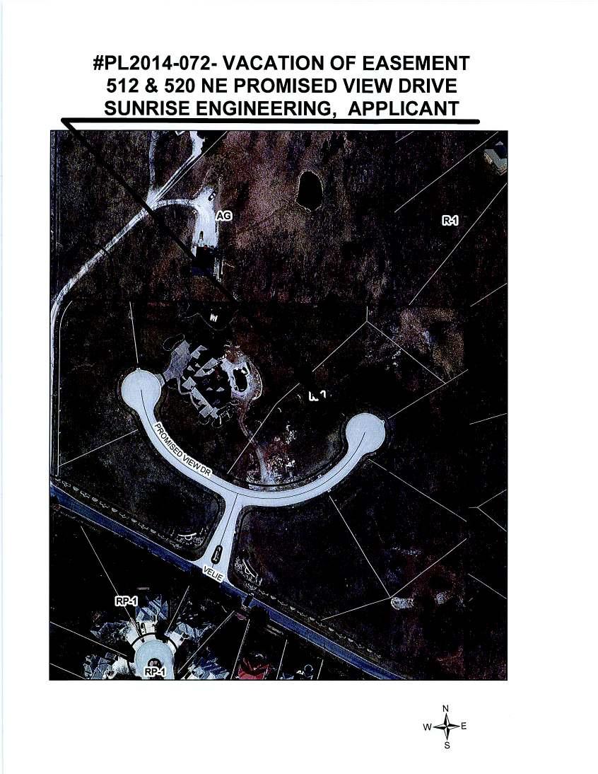
5 TO: FROM: City of Lee s Summit Department of Planning & Codes Administration Stephen A. Arbo, City Manager Robert G. McKay, AICP, Director August 13, 2014 RE: ORDINANCE - Application #PL VACATION OF UTILITY EASEMENT 512 & 520 NE Promised View Drive, Sunrise Engineering, applicant Commentary The applicant proposes to vacate 15 utility easement centered on the common property line between Lots 3A and 4A, Tiffany Woods 2 nd Plat, Lots 1A-4A, Lots 6A-8A, & Tracts A-1, B-1, and C-1 (512 & 520 NE Promised View Drive). There are no public utilities in the subject easement proposed to be vacated. No objection was raised by the City s Public Works, Water Utilities Departments or other utility companies. Proposed City Council Motion First Motion: I move for a second reading. Second Motion: I move for adoption Planning Commission Action Date of Meeting: August 12, 2014 Recommendation: easement. Recommendation Voted by consent to recommend APPROVAL of the vacation of Staff recommends APPROVAL of the vacation of utility easement. Project Information Vacation of Easement: The easement is a 15 utility easement centered on the common property line between Lots 3A and 4A, Tiffany Woods 2 nd Plat, Lots 1A-4A, Lots 6A-8A, & Tracts A-1, B-1, and C-1 Location: 512 & 520 NE Promised View Drive Zoning: R-1 (Single-family residential) Surrounding zoning and use: North: R-1 single-family residential, Tiffany Woods development South: R-1 (across NE Promised View Drive) single-family residential, Tiffany Woods development East: R-1 single-family residential, Tiffany Woods development West: R-1 single-family residential, Tiffany Woods development #PL VOE 512 & 520 NE Promised View Dr Page 1
6 Background December 18, 1984 The Board of Aldermen approved a final plat (Appl. # ) for Hilltop, Lots 1 and 2, by Ordinance No July 8, 2004 The City Council approved a rezoning (Appl. # ) from District AG (Agricultural) to District R-1 (Single-family residential) for land located at 500 NE Velie Road by Ordinance No December 16, 2004 The City Council approved a Final Plat (Appl. # ) for Tiffany Woods, Lots 1-13 & Tracts A-C by Ordinance No December 4, 2008 The City Council approved a Final Plat (Appl. # ) for Tiffany Woods, 2 nd Plat, Lots 1A-4A, 6A-8A and Tracts A-1, B-1 and C-1 by Ordinance No Analysis of Vacation of Easement The applicant proposes to vacate an unnecessary 15 utility easement centered on the common property line between Lots 3A and 4A, Tiffany Woods 2 nd Plat, Lots 1A-4A, Lots 6A-8A, & Tracts A-1, B-1, and C-1 (512 & 520 NE Promised View Drive). Letters were sent to the utility companies (KCP&L, Laclede Gas, AT&T, Time Warner and Comcast Cable), as well as to the City s Public Works and Water Utilities Department, for comment. No objection was raised by the City s Public Works, Water Utilities Departments or other utility companies. RGM/res Attachments: 1. Ordinance 2. Drawing of the easement to be vacated and legal description, dated June 18, pages 3. Location Map #PL VOE 512 & 520 NE Promised View Dr Page 2
7
8
9
City Council Information Form
 City Council Information Form DATE: 06/12/2015 ASSIGNED STAFF: Christina Stanton DEPARTMENT: Planning&Development TYPE OF FORM: Ordinances Form No.: 4898 APPROVALS: None ISSUE/REQUEST: AN ORDINANCE ACCEPTING
City Council Information Form
 City Council Information Form DATE: 02/04/2015 ASSIGNED STAFF: Mark Dunning DEPARTMENT: Development Center TYPE OF FORM: Other Business Form No.: 4704 APPROVALS: None ISSUE/REQUEST: AN ORDINANCE APPROVING
City Council Information Form
 City Council Information Form DATE: 06/17/2015 ASSIGNED STAFF: Dawn Bell DEPARTMENT: Development Center TYPE OF FORM: Other Business Form No.: 4912 APPROVALS: None ISSUE/REQUEST: AN ORDINANCE APPROVING
City Council Information Form
 City Council Information Form DATE: 08/12/2015 ASSIGNED STAFF: Trevor Stiles DEPARTMENT: Law Department TYPE OF FORM: Ordinances Form No.: 4975 APPROVALS: law: tstiles 08/12/2015 ISSUE/REQUEST: AN ORDINANCE
City Council Information Form
 City Council Information Form DATE: 12/11/2015 ASSIGNED STAFF: Robert McKay DEPARTMENT: Planning&Development TYPE OF FORM: Public Hearing Form No.: 5132 APPROVALS: None ISSUE/REQUEST: PUBLIC HEARING Appl.
CITY OF OCALA CITY COUNCIL REPORT Council Meeting Date: 06/06/17
 CITY OF OCALA CITY COUNCIL REPORT Council Meeting Date: 06/06/17 Subject: Large Scale Land Use Map Amendment Submitted By: David Boston Department: Growth Management STAFF RECOMMENDATION (Motion Ready):
City Council Information Form
 City Council Information Form DATE: 08/12/2015 ASSIGNED STAFF: Michael Weisenborn DEPARTMENT: Development Center TYPE OF FORM: Ordinances Form No.: 4972 APPROVALS: law: tstiles 08/12/2015 ISSUE/REQUEST:
GeoPoint 1403 E. 5th Avenue Tampa, Florida
 AIRPORT ROAD PINELAND P.R.D. SUBDIVISION - PHASE 1 DEDICATION: CERTIFICATE OF REVIEW BY SURVEYOR, CITY OF ORMOND BEACH DEDICATION: THIS IS TO CERTIFY THAT FORESTAR (USA) REAL ESTATE GROUP INC., A DELAWARE
ORDINANCE NO AN ORDINANCE AMENDING THE URBANA ZONING MAP. (Rezoning Multiple Properties to B-4 / Plan Case No.
 Passed: March 05, 2018 Signed: March 06, 2018 ORDINANCE NO. 2018-03-019 AN ORDINANCE AMENDING THE URBANA ZONING MAP (Rezoning Multiple Properties to B-4 / Plan Case No. 2329-M-18) WHEREAS, the Urbana Zoning
CITY OF PAPILLION MAYOR AND CITY COUNCIL REPORT MAY 16, 2018 AGENDA
 CITY OF PAPILLION MAYOR AND CITY COUNCIL REPORT MAY 16, 2018 AGENDA Subject: Type: Submitted By: A request to vacate the Final Plat for Prairie Queen First Subdivision, a subdivision legally described
RESOLUTION NO. RD:EEH:LCP
 RESOLUTION NO. A RESOLUTION OF THE COUNCIL OF THE CITY OF SAN JOSE CONDITIONALLY VACATING A PORTION OF MERIDIAN AVENUE, SOUTH OF FRUITDALE AVENUE, AND RESERVING A PUBLIC SERVICE EASEMENT OVER THE VACATED
City Council Agenda Item #13_ Meeting of October 10, 2016
 City Council Agenda Item #13_ Meeting of October 10, 2016 Brief Description Recommendation Resolution approving vacation of existing drainage and utility easements located at 4301 Highview Place and an
ORDINANCE NO. Z REZONING NO
 ORDINANCE NO. Z- 3960 REZONING NO. 2018-00014 AN ORDINANCE RELATING TO ZONING: AMENDING CERTAIN ZONING REGULATIONS SHOWN ON SHEET NO. 15 OF THE ZONING DISTRICT MAP INCORPORATED BY REFERENCE BY OVERLAND
ORDINANCE NO. CID-3087
 ORDINANCE NO. CID-3087 AN ORDINANCE MAKING FINDINGS AS TO THE NATURE AND ADVISABILITY OF CREATING A COMMUNITY IMPROVEMENT DISTRICT AT THE NORTHEAST CORNER OF 91 ST STREET AND METCALF AVENUE; CREATING SAID
DRAINAGE AND UTILITY EASEMENT. That Bruce Conrad, a single adult, hereinafter referred to as Grantor for good and
 DRAINAGE AND UTILITY EASEMENT KNOW ALL PERSONS BY THESE PRESENTS: That Bruce Conrad, a single adult, hereinafter referred to as Grantor for good and valuable consideration, the receipt and sufficiency
AGENDA UPDATE ECONOMIC DEVELOPMENT & FINANCE STANDING COMMITTEE MEETING MONDAY, AUGUST 10, 2015 III. COMMITTEE AGENDA
 AGENDA UPDATE ECONOMIC DEVELOPMENT & FINANCE STANDING COMMITTEE MEETING MONDAY, AUGUST 10, 2015 III. COMMITTEE AGENDA REVISED ITEM NO. 4 150217.ORDINANCE: VACATION VILLAGE AREAS 1 AND 2A Synopsis: A revised
RESOLUTION NO. BE IT RESOLVED BY THE COUNCIL OF THE CITY OF SAN JOSE THAT:
 RESOLUTION NO. A RESOLUTION OF THE COUNCIL OF THE CITY OF SAN JOSE SETTING A PUBLIC HEARING TO CONSIDER WHETHER TO CONDITIONALLY VACATE A 12,903 SQUARE FOOT PORTION OF OLD WEST JULIAN STREET BETWEEN NORTH
WHEREAS, the Petition was filed by PATRICK AND KIMBERLY SHULER for the vacation of plat on property described herein; and
 VP 15-0003 RESOLUTION 2-16 A RESOLUTION PROVIDING FOR THE VACATION OF PLAT FOR A PUBLIC UTILITY AND DRAINAGE EASEMENT UNDERLYING A PREVIOUSLY VACATED RIGHT-OF-WAY BEING A PART OF SW 28 PLACE ADJACENT TO
UNOPPOSED ORDER GRANTING RECEIVER'S MOTION TO APPROVE THE SALE OF REAL PROPERTY OWNED BY MAMC EMERALD CAY, LLC
 IN THE CIRCUIT COURT OF THE ELEVENTH JUDICIAL CIRCUIT IN AND FOR MIAMI-DADE COUNTY, FLORIDA STATE OF FLORIDA, OFFICE OF FINANCIAL REGULATION, Plaintiff, v. BERMAN MORTGAGE CORPORATION, a Florida corporation,
GeoPoint 213 Hobbs Street Tampa, Florida
 AIRPORT ROAD PINELAND P.R.D. SUBDIVISION - PHASES 2 & 3 DESCRIPTION: A parcel of land lying in Sections 13 and 24, Township 14 South, Range 31 East, Volusia County, Florida, and being more particularly
BILL NO (Emergency Measure) ORDINANCE NO. 5072
 ORDINANCE NO. 5072") BILL NO. 5210 (Emergency Measure) ORDINANCE NO. 5072 AN ORDINANCE AUTHORIZING THE MAYOR TO EXECUTE WITH MICHELSON-HADLEY HEIGHTS DEVELOPMENT, LLC, A CONTRACT AND QUIT CLAIM DEED CONVEYING CERTAIN PROPERTIES
BILL NO. 5210 (Emergency Measure) ORDINANCE NO. 5072 AN ORDINANCE AUTHORIZING THE MAYOR TO EXECUTE WITH MICHELSON-HADLEY HEIGHTS DEVELOPMENT, LLC, A CONTRACT AND QUIT CLAIM DEED CONVEYING CERTAIN PROPERTIES
City of Grand Island Tuesday, August 8, 2017 Council Session
 City of Grand Island Tuesday, August 8, 2017 Council Session Item F-1 #9638 - Consideration of Correction to Ordinance No. 9631 Relative to Vacation of the North End of Voss Road; North of Seedling Mile
OFFICIAL SUMMARY OF AN ORDINANCE TO CONVEY CERTAIN RAMSEY COUNTY PARK AND OPEN SPACE LANDS TO THE CITY OF MAPLEWOOD.
 OFFICIAL SUMMARY OF AN ORDINANCE TO CONVEY CERTAIN RAMSEY COUNTY PARK AND OPEN SPACE LANDS TO THE CITY OF MAPLEWOOD. This ordinance authorizes the conveyance of park and open space land owned by Ramsey
City Council Agenda Item #13_ Meeting of March 6, 2017
 City Council Agenda Item #13_ Meeting of March 6, 2017 Description Recommendation Resolution vacating a sump easement and drainage and utility easements located at 1555 Linner Road. Hold the public hearing
to St. Louis County by deed recorded in Book 7954, Page 235 in the St. Louis County, Missouri
 Recommendation of Planning Commission BILL NO. 4032 ORDINANCE NO. 2015-3971 AN ORDINANCE ENACTING A CONDITIONAL USE PERMIT FOR AN ELECTRICAL SUBSTATION AT 11520 DORSETT ROAD Petition of Ameren Missouri)
WHEREAS, the Petition is in all ways in complete compliance with the provisions of the Act; and,
 ORDINANCE NO. 15,700 AN ORDINANCE continuing the Downtown Des Moines Self-Supported Municipal Improvement District pursuant to the provisions of Chapter 386, Code of Iowa; and providing for the continuation
CHAPTER XIX ANNEXATION ARTICLE 1. ANNEXATION
 CHAPTER XIX ANNEXATION ARTICLE 1. ANNEXATION 19.0101 JABORSKY ADDITION: WHEREAS, The City of Belfield pursuant to Section 40-51.2-07 of the North Dakota Century Code has amended having passed a Resolution
ORDINANCE NO (PROPOSED)
") ORDINANCE NO. 1604 (PROPOSED) AN ORDINANCE OF THE CITY OF COCOA BEACH, BREVARD COUNTY, FLORIDA; AMENDING THE OFFICIAL ZONING MAP OF THE CITY OF COCOA BEACH, BY CHANGING THE ZONING DESIGNATION ON TWO PARCELS
ORDINANCE NO. 1604 (PROPOSED) AN ORDINANCE OF THE CITY OF COCOA BEACH, BREVARD COUNTY, FLORIDA; AMENDING THE OFFICIAL ZONING MAP OF THE CITY OF COCOA BEACH, BY CHANGING THE ZONING DESIGNATION ON TWO PARCELS
CONVEYANCE - COMMONWEALTH PROPERTY IN THE BOROUGH OF EAST STROUDSBURG, MONROE COUNTY Act of Jul. 1, 2016, P.L., No. 65 Cl.
 CONVEYANCE - COMMONWEALTH PROPERTY IN THE BOROUGH OF EAST STROUDSBURG, MONROE COUNTY Act of Jul. 1, 2016, P.L., No. 65 Cl. 85 An Act Authorizing the Department of General Services, with the approval of
ORDINANCE WHEREAS, the Planning and Zoning Board of the City of Belleview has been designated as the Local Planning Agency; and
 Page 1 of 9 ORDINANCE 2019-03 AN ORDINANCE OF THE CITY OF BELLEVIEW, FLORIDA RELATING TO AN AMENDMENT OF 8.87 +/- ACRES OF LAND TO THE CITY OF BELLEVIEW COMPREHENSIVE PLAN; AMENDING THE FUTURE LAND USE
DEPARTMENT OF COMMUNITY DEVELOPMENT SERVICES. Economic Development Division. m e m o r a n d u m
 DEPARTMENT OF COMMUNITY DEVELOPMENT SERVICES Economic Development Division m e m o r a n d u m TO: FROM: Mayor Diane Wolfe Marlin and City Council Members John A. Schneider, MPA, Community Development
ORDINANCE NO (PROPOSED)
") ORDINANCE NO. 1603 (PROPOSED) AN ORDINANCE OF THE CITY OF COCOA BEACH, BREVARD COUNTY, FLORIDA; AMENDING THE COCOA BEACH COMPREHENSIVE PLAN BY AMENDING THE FUTURE LAND USE MAP 2025 (FLUE 2) BY CHANGING
ORDINANCE NO. 1603 (PROPOSED) AN ORDINANCE OF THE CITY OF COCOA BEACH, BREVARD COUNTY, FLORIDA; AMENDING THE COCOA BEACH COMPREHENSIVE PLAN BY AMENDING THE FUTURE LAND USE MAP 2025 (FLUE 2) BY CHANGING
;:ft{n Siegel, City Manager
 5/17/2016 03 City of San Juan Capistrano Agenda Report TO: FROM: Honorable Mayor and Members of the City Council ;:ft{n Siegel, City Manager SUBMITTED BY: Steve May, Public Works and Utilities Director
The City Council of the City of Sulphur, Louisiana, met in special session at its
 July 12, 2018 The City Council of the City of Sulphur, Louisiana, met in special session at its regular meeting place in the Council Chambers, Sulphur, Louisiana, on July 12, 2018 at 5:00 p.m., after full
1~1~ 1i i11mmi ~m
 1~1~ 1i1111111111i11mmi111111111~m 20180521-0006702 5/ 21/ 2018 Pages: 10 F : $0. 00 2 : 11 PM Register of Deeds T20180026529 COVER SHEET TITLE OF DOCUMENT: Ordinance No. 18-17 (Creation of The Olathe
ORDINANCE NO AN ORDINANCE To Be Entitled:
 3808 AN ORDINANCE To Be Entitled: AN ORDINANCE OF THE CITY COUNCIL OF THE CITY OF FORT MYERS, FLORIDA, REZONING FROM COMMERCIAL GENERAL TO PLANNED UNIT DEVELOPMENT AND APPROVING THE DEVELOPMENT PLAN FOR
VICINITY MAP SCALE 1'' = 2000'
 CITY CREEK ANNEXATION TO THE CITY OF THORNTON LOCATED IN THE SOUTHWEST QUARTER OF SECTION 11 AND THE WEST HALF OF SECTION 14, TOWNSHIP 1 SOUTH, RANGE 68 WEST OF THE 6TH PRINCIPAL MERIDIAN, COUNTY OF ADAMS,
TOWN OF LYONS, COLORADO ORDINANCE NO. 1017
 TOWN OF LYONS, COLORADO ORDINANCE NO. 1017 AN ORDINANCE OF THE BOARD OF TRUSTEES OF THE TOWN OF LYONS ANNEXING TO THE TOWN OF LYONS CERTAIN REAL PROPERTY OWNED BY THE TOWN OF LYONS WHEREAS, the Town of
MEMORANDUM. Mayor and City Council. Warren Hutmacher, City Manager. Date: February 11, 2013
 MEMORANDUM To: From: Mayor and City Council Warren Hutmacher, City Manager Date: February 11, 2013 Subject: Approval of an Intergovernmental agreement by and between the City of Dunwoody and DeKalb County
MINNETONKA PLANNING COMMISSION October 26, Rear yard setback variance for a deck expansion at 5732 Kipling Avenue
 MINNETONKA PLANNING COMMISSION October 26, 2017 Brief Description Rear yard setback variance for a deck expansion at 5732 Kipling Avenue Recommendation Adopt the resolution approving the variance Background
Business Item No xxx
 Business Item No. 2015-xxx Metropolitan Parks and Open Space Commission Meeting date: October 6, 2015 For the Community Development Committee meeting of October 19, 2015 For the Metropolitan Council meeting
RESOLUTION NO. R To Acquire Real Property Interests Required for the Operations and Maintenance Satellite Facility
 RESOLUTION NO. R2015-35 To Acquire Real Property Interests Required for the Operations and Maintenance Satellite Facility MEETING: DATE: TYPE OF ACTION: STAFF CONTACT: Capital Committee Board PROPOSED
COUNCIL AGENDA MEMO ITEM NO. III - #1
 COUNCIL AGENDA MEMO ITEM NO. III - #1 FROM: Anton Jelinek, Director of Utilities MEETING: October 24, 2017 SUBJECT: PRESENTER: Permanent Utility and Right-of-Way Easement Anton Jelinek Discussion: At the
WATERFORD LANDING COMMUNITY DEVELOPMENT DISTRICT REGULAR MEETING AGENDA
 WATERFORD LANDING COMMUNITY DEVELOPMENT DISTRICT REGULAR MEETING AGENDA January 31, 2019 Waterford Landing Community Development District OFFICE OF THE DISTRICT MANAGER 2300 Glades Road, Suite 410W Boca
RESOLUTION NO WHEREAS, William Parrott and Peggy Parrott, his wife ("Applicants"), the owners of
, the owners of") ". fcf 1 Resolution 595 Page 1 INSTR # 1696524 OR BK 1822 PG 717 RECORDED 9/3/23 11:12:41 AM MARSHA EWING CLERK OF MARTIN COUNTY FLORIDA RECORDED BY C Burkey RESOLUTION NO. 595 A RESOLUTION OF THE TOWN
". fcf 1 Resolution 595 Page 1 INSTR # 1696524 OR BK 1822 PG 717 RECORDED 9/3/23 11:12:41 AM MARSHA EWING CLERK OF MARTIN COUNTY FLORIDA RECORDED BY C Burkey RESOLUTION NO. 595 A RESOLUTION OF THE TOWN
for the Logan Golf and Country Club; and
 CITY OF LOGAN ORDINANCE NO. 16-01 AN ORDINANCE VACATING PUBLIC RIGHTS-OF-WAY INCLUDING 700 NORTH AND 900 NORTH FROM 1600 EAST TO THE EASTERN CITY BOUNDARY, 2000 EAST FROM 700 NORTH TO 900 NORTH AND A BROAD
RESOLUTION NO. NOW, THEREFORE, BE IT RESOLVED BY THE COUNCIL OF THE CITY OF SAN JOSE THAT:
 RD:EH 2/11/16 RESOLUTION NO. A RESOLUTION OF THE COUNCIL OF THE CITY OF SAN JOSE SUMMARILY VACATING A PEDESTRIAN ACCESS EASMENT LOCATED BETWEEN CASSELINO DRIVE AND MULLINIX WAY AND RESERVING AND EXCEPTING
The complete Petition to Vacate was submitted by Thomas Hoolihan of Seago Group Inc., Raymond F. Dibble, Trustee, and 3everly A. Dibble, Trustee.
 K rion REOUFSTED: Adopt a Resolution on Petition VAC2001-00063 to Vacate a portion of the cul-de-sac for River Club Ct. (f.k Nalter Hagen Ct.) as recorded in Plat Book 34, Page 13, in the Public Records
LOCATION MAP: AERIAL PHOTOGRAPH, 2015:
 LOCATION MAP: AERIAL PHOTOGRAPH, 2015: ORDINANCE NO. AN ORDINANCE OF THE CITY OF BRYAN, TEXAS, AMENDING CHAPTER 130, ZONING, OF THE CITY OF BRYAN CODE OF ORDINANCES, BY CHANGING THE ZONING CLASSIFICATION
DISTRICT. Huntington Beach. FIM 40-40C-3 APN and
 RECORDING REQUESTED BY W HEN RECORDED MAIL TO SOUTHERN CALIFORNIA EDISON COMPANY 2131 WALNUT GROVE AVENUE 2 ND FLOOR GO3 ROSEMEAD, CA 91770 Attn: Title and Real Estate Services SPACE ABOVE THIS LINE FOR
The North 140 Feet of Lot 4, Block 6, Metcalf View Second Plat, a subdivision of land in the City of Overland Park, Johnson County, Kansas.
 NOTICE OF PUBLIC HEARING CITY PLANNING COMMISSION CITY OF OVERLAND PARK, KANSAS Notice is hereby given that the City Planning Commission of Overland Park, Kansas, will hold a public hearing Monday, June
COUNCIL ACTION FORM VACATION AND CONVEYANCE OF APPLE PLACE AND PEACH LANE RIGHT-OF-WAY TO THE OLD ORCHARD/CREEKSIDE MOBILE HOME PARK
 ITEM # 21&22 DATE: 03-27-18 COUNCIL ACTION FORM SUBJECT: VACATION AND CONVEYANCE OF APPLE PLACE AND PEACH LANE RIGHT-OF-WAY TO THE OLD ORCHARD/CREEKSIDE MOBILE HOME PARK BACKGROUND: City of Ames staff
STAFF REPORT. Planning and Zoning Case 16-20FP Staff: Michael Peterman, City Planner Date: May 23, 2016
 STAFF REPORT Planning and Zoning Case 16-20FP Staff: Michael Peterman, City Planner Date: May 23, 2016 GENERAL INFORMATION Application: Applicant: Location: Existing Land Use/Zoning: Future Land Use Designation:
Exhibit A PROPERTY: LEGAL DESCRIPTION AND MAP. (Included on following pages)
") Exhibit A PROPERTY: LEGAL DESCRIPTION AND MAP (Included on following pages) Exhibit A A-1 The Dow Chemical Company Trust Lands Lease RBF CONSULTING, a Company of Michael Baker International 500 Ygnacio
Exhibit A PROPERTY: LEGAL DESCRIPTION AND MAP (Included on following pages) Exhibit A A-1 The Dow Chemical Company Trust Lands Lease RBF CONSULTING, a Company of Michael Baker International 500 Ygnacio
CITY OF WACONIA RESOLUTION
 CITY OF WACONIA RESOLUTION 2014-212 TOWNSHIP OF LAKETOWN RESOLUTION~~- \0 JOINT RESOLUTION STIPULATING TO THE AMENDMENT OF ORDERLY ANNEXATION AGREEMENT NO. 76-47 AND TO THE ORDERLY ANNEXATION OF THE RYLAND
Add on item to regular section of agenda: FDOT Draft Tentative Work Program
 MEMORANDUM To: Robin Meyer, AICP, Planning Section Manager From: Bobbi Roy, Planning Coordinator Date: December 3, 2014 Subject: Agenda Update for the December 4, 2014 Board of County Commissioners Land
ARTICLES OF INCORPORATION
 Cherry Creek Vista Homeowners Association June, 2009 The following pages were retyped from copies of the original documents. The original documents are available through the Arapahoe County, Colorado,
REVIEWED BY: Administrator Counsel Program Mgr.: Tiffany Schaufler Board Committee Engineer Other
 Minnehaha Creek Watershed District REQUEST FOR BOARD ACTION MEETING DATE: May 11, 2017 TITLE: Authorization to Grant a Temporary Easement to the City of Minnetrista RESOLUTION NUMBER: 17-034 PREPARED BY:
FOR LEGAL DESCRIPTION, SEE EXHIBIT "A" ATTACHED HERETO AND MADE APART HEREOF.
 RECORDING REQUESTED BY SOUTHERN CALIFORNIA EDISON WHEN RECORDED MAIL TO SOUTHERN CALIFORNIA EDISON COMPANY Real Properties 2131 Walnut Grove Avenue, 2nd Floor Rosemead, CA 91770 Attn: Distribution/TRES
DEPARTMENT OF COMMUNITY DEVELOPMENT SERVICES. Economic Development Division. m e m o r a n d u m
 DEPARTMENT OF COMMUNITY DEVELOPMENT SERVICES Economic Development Division m e m o r a n d u m TO: FROM: Mayor Diane Wolfe Marlin and City Council John A. Schneider, MPA, Community Development Manager
THE BOARD OF COUNTY COMMISSIONERS OF THE COUNTY OF CLARK, STATE OF NEV ADA, DOES HEREBY ORDAIN AS FOLLOWS:
 BILI,, NO., 6-6-18-2 SUMMARY - An ordinance to amend the official zoning map to reflect certain zone changes. - ORDINANCE NO. ------------- 4596 (of Clark County, Nevada) AN ORDINANCE TO AMEND THE OFFICIAL
Planning Commission Application Summary
 Planning Commission Application Summary Project Name: Academy Office Park Plat Amendment Request Address: 339 West 13490 South Current Zoning: CSD-DPMU Hearing Date: August 11, 2016 Summary of Request
TOWN OF WOODBURY NOTICE AND WARNING OF SPECIAL TOWN MEETING MARCH 16, 2016
 TOWN OF WOODBURY NOTICE AND WARNING OF SPECIAL TOWN MEETING MARCH 16, 2016 Pursuant to Sections 203 and 204 of the Woodbury Charter, all electors and citizens qualified to vote in town meetings of the
Stenberg Annexation Legal Diagram Exhibit "B" W Subject Property Annexed to the City of Red Bluff VICINITY MAP "1:3:
 Stenberg Annexation Legal Diagram Exhibit "B" W Subject Property Annexed to the City of Red Bluff VICINITY MAP "1:3: ORDINANCE NO. 991 REZONE NO. 210 AN ORDINANCE AMENDING SECTION 25.13 OF THE RED BLUFF
ORDINANCE NO. 53. BE IT ENACTED AND ORDAINED by the Council of the Borough of Indian lake, Somerset
 ORDINANCE NO. 53 ORDINANCE OF THE BOROUGH OF INDIAN LAKE, PENNSYLVANIA, AMENDING ORDINANCE NO. 52, AN ORDINANCE "APPROVING A REQUESTED CHANGE OF BOROUGH LIMITS, ANNEXING A PORTION OF STONYCREEK TOWNSHIP,
RESOLUTION NO
 RESOLUTION NO. 16-35 A RESOLUTION ORDERING THE ABATEMENT OF CONDITIONS CREATING A NUISANCE AND A HAZARDOUS PROPERTY EXISTING AT 35 WOODLAWN AVENUE, IN THE CITY OF TONKA BAY WHEREAS, the property located
INTERGOVERNMENTAL AGREEMENT
 INTERGOVERNMENTAL AGREEMENT This Intergovernmental Agreement (this Agreement) is made and entered into as of December 1, 2010, by and between the VILLAGE OF BIG ROCK, an Illinois municipal corporation
MONDAY, JULY 16, :00 P.M. * 4. Approve, as submitted, minutes of regular meeting held July 2, 2012.
 MONDAY, JULY 16, 2012 8:00 P.M. 1. Pledge of Allegiance led by Village Clerk Marlene Williams. 2. Call meeting to order and roll call. 3. Approve Consent Agenda. * 4. Approve, as submitted, minutes of
RESOLUTION NO
 RESOLUTION NO. 2009 233 A RESOLUTION OF THE CITY COUNCIL OF THE CITY OF ELK GROVE QUITCLAIMING A PORTION OF ABANDONED EAST STOCKTON BOULEVARD TO ELK GROVE V PARTNERS, LLC PURSUANT TO AN AGREEMENT WHEREAS,
APPLICATION TO REGISTER NOTICE OF AN AGREEMENT THE LAND TITLES ACT SECTION 74
 26 th May 1981 Campeau - City of Kanata 40% Open Space Agreement APPLICATION TO REGISTER NOTICE OF AN AGREEMENT THE LAND TITLES ACT SECTION 74 TO: THE LAND REGISTRAR FOR THE LAND TITLES DIVISION OF OTTAWA-CARLETON
ANDERSON HALL PUD TEXT AMENDMENT PRESENTED BY STEVEN D. HARDIN, ESQ.
 ANDERSON HALL PUD TEXT AMENDMENT PRESENTED BY STEVEN D. HARDIN, ESQ. TOWN COUNCIL REQUEST FOR THIRD READING MARCH 17, 2014 TABLE OF CONTENTS 141ST STREET & PROMISE ROAD PUD Petitioner Craig H. Lintner
ORDINANCE NO. 408 THE COUNCIL OF THE CITY OF BRECKENRIDGE, MINNESOTA, DOES ORDAIN:
 ORDNANCE NO. 48 REC'D. BY MMB NOV 16 1987 AN ORDNANCE EXTENDNG THE CORPORATE LMTS OF THE CTY OF BRECKENRDGE TO NCLUDE CERTAN UNNCORPORATED PLATTED LAND NOT EXCEEDNG 2 ACRES N AN AREA ABUTTNG UPON THE CTY
SECOND AMENDMENT TO LOCAL DEVELOPMENT AGREEMENT [Amazon] WITNESSETH:
![SECOND AMENDMENT TO LOCAL DEVELOPMENT AGREEMENT [Amazon] WITNESSETH:](/thumbs/89/99824086.jpg "SECOND AMENDMENT TO LOCAL DEVELOPMENT AGREEMENT [Amazon] WITNESSETH:") SECOND AMENDMENT TO LOCAL DEVELOPMENT AGREEMENT [Amazon] This SECOND AMENDMENT TO LOCAL DEVELOPMENT AGREEMENT ("Second Amendment") is made and entered into this 6 1 h day of April, 2017, by and between
SECOND AMENDMENT TO LOCAL DEVELOPMENT AGREEMENT [Amazon] This SECOND AMENDMENT TO LOCAL DEVELOPMENT AGREEMENT ("Second Amendment") is made and entered into this 6 1 h day of April, 2017, by and between
AN ACT. The General Assembly of the Commonwealth of Pennsylvania hereby enacts as follows:
 CONVEYANCES - COMMONWEALTH PROPERTY IN LIGONIER BOROUGH, WEST MORELAND COUNTY; CITY OF CONNELLSVILLE, FAYETTE COUNTY; CITY OF ALLENTOWN, LEHIGH COUNTY; BENSALEM TOWNSHIP, BUCKS COUNTY, AND SUSQUEHANNA
In Rem Foreclosure of Tax Liens By Lafayette County For Tax Years
 In Rem Foreclosure of Tax Liens By Lafayette County For Tax Years 2007-2011 Properties owned by Lafayette County, WI Sealed Bid Auction Date: November 13, 2015 Sealed Bid Auction Time: 11:00 a.m. Sealed
IN THE DISTRICT COURT OF McPHERSON COUNTY, KANSAS
 IN THE DISTRICT COURT OF McPHERSON COUNTY, KANSAS THE BOARD OF COUNTY COMMISSIONERS ) OF MCPHERSON COUNTY, KANSAS ) PLAINTIFF ) VS. ) CASE NO. 2014 CV 84 ) THE DALE L. BAIR LIVING TRUST ) DATED FEBRUARY
Village of Mantua, Ohio ORDINANCE
 AN ORDINANCE AUTHORIZING THE MAYOR TO EXECUTE A LEASE / OPTION TO PURCHASE AGREEMENT WITH THE PORTAGE PARK DISTRICT FOR THE HEADWATERS TRAIL WEST OF STATE ROUTE 44, AND DECLARING AN EMERGENCY. WHEREAS,
David L. Brown, Construction Services Manager
 Memorandum Date: 2/02/2013 Order Date: 2/27/2013 TO: DEPARTMENT: PRESENTED BY: AGENDA ITEM TITLE: Board of County s Public Works David L. Brown, Construction Services Manager In the Matter of Authorizing
LANDSCAPE AND MAINTENANCE EASEMENT. THIS LANDSCAPE AND MAINTENANCE EASEMENT, (hereinafter Easement )
") Prepared by and return to: Parcel ID # LANDSCAPE AND MAINTENANCE EASEMENT THIS LANDSCAPE AND MAINTENANCE EASEMENT, (hereinafter Easement ) is made and entered into this day of, 2009, by and between THIRD
Prepared by and return to: Parcel ID # LANDSCAPE AND MAINTENANCE EASEMENT THIS LANDSCAPE AND MAINTENANCE EASEMENT, (hereinafter Easement ) is made and entered into this day of, 2009, by and between THIRD
AMBER CREEK METROPOLITAN DISTRICT. Resolution to Adopt Fees Regarding Covenant Enforcement, Design Review and Maintenance Services
 AMBER CREEK METROPOLITAN DISTRICT Resolution to Adopt Fees Regarding Covenant Enforcement, Design Review and Maintenance Services WHEREAS, Amber Creek Metropolitan District ( District ) is a quasi-municipal
WHEREAS, the Planning and Zoning Commission, at its meeting on July 9, 2018, recommended the approval of the zoning request by the City Council; and
 BILL NO. ORDINANCE NO. AN ORDINANCE ESTABLISHING A LI: LIGHT INDUSTRIAL DISTRICT FOR PROPERTY RECENTLY ANNEXED INTO THE CITY OF WARRENSBURG, MISSOURI, LOCATED AT THE NORTHEAST CORNER OF THE INTERSECTION
FIFTH AMENDMENT OF DECLARATION OF DEED RESTRICTIONS AND DEDICATIONS FOR PINEHURST ESTATES (A Clatsop County, Oregon Subdivision)
") After Recording Return To: W. Louis Larson 990 Astor Street Astoria, OR 97103 FIFTH AMENDMENT OF DECLARATION OF DEED RESTRICTIONS AND DEDICATIONS FOR PINEHURST ESTATES (A Clatsop County, Oregon Subdivision)
After Recording Return To: W. Louis Larson 990 Astor Street Astoria, OR 97103 FIFTH AMENDMENT OF DECLARATION OF DEED RESTRICTIONS AND DEDICATIONS FOR PINEHURST ESTATES (A Clatsop County, Oregon Subdivision)
Sketch & Legal Description of Mitigation Bank and Ingress/Egress Access Easements
 Appendix H: Sketch & Legal Description of Mitigation Bank and Ingress/Egress Access Easements Tippen Bay Wetland Mitigation Bank DeSoto County, Florida Prepared by: September, 2017 Original file
City of Fayetteville, Arkansas Page 1 of 1
 City of Fayetteville, Arkansas 113 West Mountain Street Fayetteville, AR 72701 (479) 575-8323 Legislation Text File #: 2018-0399, Version: 1 VAC 18-6148 (1901 S. HARDING PL./THOMPSON): AN ORDINANCE TO
COUNCIL COMMUNICATION
 Meeting Date: October 24, 2017 COUNCIL COMMUNICATION Agenda Item: Agenda Location: Public Hearings Work Plan # Legal Review: X 1 st Reading 2 nd Reading Subject: A public hearing regarding Zoning and a
ABBREVIATION LEGEND SITE INFORMATION:
 SITE INFORMATION: Current Zone: R-3 PUD, governed by Fox Hollow 2nd MDA Basis of Elevations: Northeast Corner of Section 13, T6S, R1W, S.L.B. & M Elevation: 4599.26 (Benchmark) ABBREVIATION LEGEND Owners:
WHEREAS, are existing rights-of-way that extend through Utah State University property that are used the Golf Country Club; and
 CITY Of LOGAN ORDINANCE NO. 16-01 AN ORDINANCE VACATING PUBLIC RIGHTS-Of-WAY INCLUDING 100 NORTH AND 900 NORTH from 1600 EAST TO THE EASTERN CITY BOUNDARY, 2000 EAST from 100 NORTH TO 900 NORTH AND A BROAD
NOW THEREFORE, BE IT ORDAINED BY THE GOVERNING BODY OF THE CITY OF RIO RANCHO:
 1 2 3 4 5 6 7 8 9 10 11 12 13 14 15 16 17 18 19 20 21 22 23 24 25 26 27 28 29 30 31 32 33 34 35 36 37 38 39 40 41 42 43 44 45 46 47 48 49 50 51 52 53 54 55 56 57 58 59 CITY OF RIO RANCHO ORDINANCE ORDINANCE
THE GENERAL ASSEMBLY OF PENNSYLVANIA SENATE BILL AN ACT
 PRINTER'S NO. THE GENERAL ASSEMBLY OF PENNSYLVANIA SENATE BILL No. INTRODUCED BY VANCE, APRIL, 00 REFERRED TO STATE GOVERNMENT, APRIL, 00 Session of 00 AN ACT 0 0 Authorizing the Department of General
LISA ANDERSON-OGILVIE, AICP DEPUTY COMMUNITY DEVELOPMENT DIRECTOR AND PLANNING ADMINISTRATOR
 FOR MEETING OF: December 12, 2018 CASE NO.: VUL18-01 TO: FROM: HEARINGS OFFICER LISA ANDERSON-OGILVIE, AICP DEPUTY COMMUNITY DEVELOPMENT DIRECTOR AND PLANNING ADMINISTRATOR SUBJECT: VALIDATION OF UNIT
CITY OF HIAWATHA, IOWA TOWN VILLAGE CENTER URBAN REVITALIZATION PLAN. for the TOWN VILLAGE CENTER URBAN REVITALIZATION AREA
 CITY OF HIAWATHA, IOWA TOWN VILLAGE CENTER URBAN REVITALIZATION PLAN for the TOWN VILLAGE CENTER URBAN REVITALIZATION AREA 2018 1 INTRODUCTION The Urban Revitalization Act, Chapter 404 of the Code of Iowa,
CITY OF NORTHVILLE FINAL REPORT HISTORIC DISTRICT BOUNDARIES
 CITY OF NORTHVILLE FINAL REPORT HISTORIC DISTRICT BOUNDARIES 2007 Background: In 2003 the Historic District Commission (HDC) undertook the task of revising the Historic District Boundaries in an effort
City Council Agenda Cover Memorandum..._.~-~..~
 City Council Agenda Cover Memorandum //..._.~-~..~ Meeting Date: November 2, 2009 Item Title: Action Requested: Second Amendment to Easement and Operating Agreement for Uptown Phase II [8J Approval D For
Old Republic National Title Insurance Company
 Old Republic National Title Insurance Company COMMITMENT FOR TITLE INSURANCE SCHEDULE A File No: 59425 Upper River Area Parcels Supplemental No. 2 1. Effective Date: June 02, 2013, 7:00 a.m. Issue Date:
ORDINANCE NO WHEREAS, the Parties desire to amend the Original Easement to add the land upon which the Monument Sign was constructed.
 Irading 2 rtadir g 2 J A/ y readtng Voled 4n 7 2 / i Ano, PASSEDX% DEFEATED ORDINANCE NO. 2019-6 AN ORDINANCE AUTHORIZING THE MAYOR TO EXECUTE THE FIRST AMENDMENT TO THE TRAFFEC CONTROL AND LANDSCAPING
BOARD OF COUNTY COMMISSIONERS SARPY COUNTY, NEBRASKA RESOLUTION TO APPROVE PARK LAND ACQUISITION FOR SID 297, SOUTHERN PINES
 2017-389 BOARD OF COUNTY COMMISSIONERS SARPY COUNTY, NEBRASKA RESOLUTION TO APPROVE PARK LAND ACQUISITION FOR SID 297, SOUTHERN PINES WHEREAS, Sanitary and Improvement District No. 297 of Sarpy County,
FLATS AT 146. Replat and Amendment to a Multi-family Planned Development DOMO DEVELOPMENT, LLC PRESENTED BY STEVEN D. HARDIN, ESQ.
 Replat and Amendment to a Multi-family Planned Development DOMO DEVELOPMENT, LLC PRESENTED BY STEVEN D. HARDIN, ESQ. NOBLESVILLE PLAN COMMISSION JUNE 16, 2014 TABLE OF CONTENTS Petitioner DOMO Development
MINNETONKA PLANNING COMMISSION June 15, 2016
 MIETOKA PLAIG COMMISSIO June 15, 2016 Brief Description Ordinance rezoning a portion of the property at 4301 Highview Place and an adjacent unaddressed parcel from R-1 to R-1A Recommendation Recommend
RESOLUTION NO. R
 ;:. /. ',. RESOLUTION NO. R-2018-1698 RESOLUTION APPROVING ZONING APPLICATION DOA-2018-01148 (CONTROL NO. 1984-00152) a Development Order Amendment APPLICATION OF King Jesus Inc BY JMorton Planning & Landscape
----':c RESOLUTION NO. ZR
 RESOLUTION NO. ZR-2018-015 RESOLUTION APPROVING ZONING APPLICATION ZV-2017-02395 CONTROL NO. 1980-00215 TYPE II VARIANCE (STAND ALONE) APPLICATION OF Gleneagles Country Club Inc BY WGINC, AGENT (GLENEAGLES