GEIST MANOR PUD. City Council 3 rd Reading. Gravel Trail. Paved Trail. Trailhead. Open Field. Woods. Playground. Canoe Launch. Firepit.
|
|
|
- Samson Norman
- 5 years ago
- Views:
Transcription


1 146th St E 116th St E 104th St GEIST MANOR PUD City Council 3 rd Reading Florid Florida Road Road 113 St. 113th Street PARK N PKWY TO PENDLETON Geist Park RTH 113TH STREET Regional Map Legend GEIST PARK FALL CREEK NATURAL AREA Hours Dawn to Dusk Olio Rd Boardwalk Southeastern Pkwy 113th St Geist Park myhamiltoncountyparks.com Florida Rd, Fortville, IN Florida Rd Fall Creek Playground P Fence Park Florida Rd Gravel Trail Paved Trail Trailhead Open Field Woods Canoe Launch Firepit Structures Picnic Shelter Parking P Gate Watershed K TRAIL Park Boundary feet N DUKE TRAIL GREENWAY FLAT FORK CREEK PARK RETAIL AREA TO FORTVILL PRESENTED BY STEVEN D. HARDIN, ESQ. November 20, 2017
2 TABLE OF CONTENTS GEIST MANOR PUD Applicant: Mann Properties LLC Tim Stevens 6925 East 96th Street, Suite 200 Indianapolis, IN NORTH 113TH EIST PAR STREET Park FALL CREEK NATURAL AR TABLE OF CONTENTS Tab 1 Executive Summary Attorney: Steven D. Hardin, Esq. India A.J.B.B. Olson, Land Use Planner Faegre Baker Daniels LLP 600 E. 96th Street, Suite 600 Indianapolis, IN Telephone: Tab 2 Tab 3 Tab 4 Tab 5 Aerial Location Map Concept Plan City s Comprehensive Plan Excerpt Proposed PUD Ordinance
3 TAB 1
4 EXECUTIVE SUMMARY GEIST MANOR PUD NORTH 113TH EIST PAR STREET Park FALL CREEK NATURAL AR Mann Properties LLC is pleased to submit its newest proposed development in Fishers to be located at 113th Street and Florida Road. The proposed development spans both the north east corner and the south east corner of this intersection and includes approximately /- acres. The proposed development will include 47 homes to be built by Fischer Homes on the north side of 113th Street (the homes are expected to range from $450,000 - $520,000) and approximately /- acres on the south side of 113th Street to be conveyed to the City for use as a public park. The planned development also will help facilitate the City s planned Geist Greenway Trail and will provide opportunities to connect the City s trail and park system to the nearby Geist Park, the planned Fall Creek Natural Area and Geist Reservoir. Update Since City Council First Reading The City s PUD Committee, at its September 6, 2017, meeting, reviewed and approved Fischer Homes proposed home plans. Also on September 6, 2017, the Plan Commission held the public hearing for this proposal. No remonstrance was made. After conducting the public hearing. The Plan Commission unanimously voted to forward the proposed PUD Ordinance to the City Council with a favorable recommendation. Revisions made to the PUD since First Reading are identified at Tab 5 either by strikethrough text or red text. Thank you for your consideration.
5 TAB 2


6 AERIAL LOCATION MAP GEIST MANOR PUD NORTH 113TH EIST PAR STREET Park FALL CREEK NATURAL AR Florida Road Florida Road 113 th Street 113 th Street 126 th St Southeastern Pkwy Pkwy Site 96 th St Olio Rd Florida Rd
7 TAB 3
8 CONCEPT PLAN GEIST MANOR PUD NORTH 113TH EIST PAR STREET Park FALL CREEK NATURAL AR Florida Rd. 113 th St. Park
9 TAB 4
10 CITY S COMPREHENSIVE PLAN EXCERPT GEIST MANOR PUD NORTH 113TH EIST PAR STREET SOUTHEASTERN PKWY Park FALL CREEK NATURAL AR TO PENDLETON NORTH 113TH MP CREEK TRAIL GEIST PARK STREET DUKE TRAIL GREENWAY Park FLAT FORK CREEK PARK RETAIL AREA FALL CREEK NATURAL AREA TO FORTVILLE Source: Primary Bike/Pedestrian Thoroughfares, Fishers 2040 Comprehensive Plan (pg. 95). Site This exhibit is an excerpt from the City s Comprehensive Plan. It shows the planned Geist Greenway Trail (formerly known as the Duke Trail Greenway) that will run from 96th Street to 136th Street, mostly following the exis ng Duke easement. Also shown are the exis ng Geist Park and the planned Fall Creek Natural Area. The Park land to be conveyed to City as part of this PUD will provide the opportunity to connect the City s planned trail network to the exis ng and planned park systems, and it will provide the City flexibility in the loca on of the Geist Greenway Trail.
11 TAB 5
12 Year 2017 THE MILLER CIOTTI GEIST MANOR PUD City of Fishers Planned Unit Development Ordinance No E
13 GEIST MANOR PUD 1.01 Declaration, Purpose and Intent, and Permitted Uses Declaration Ordinance No E (this "Ordinance") Adopted: The Unified Development Ordinance (the "UDO") of the City of Fishers, Indiana, Ordinance No A, as amended, and the Official Zoning Map of the City of Fishers, Indiana, dated June, 2017, as amended, which accompanies and is a part of the Zoning Code of the City of Fishers, Indiana, are hereby amended as follows: Purpose and Intent The purpose of this PUD is to encourage improved design in the development of land by promoting greater flexibility in applying the UDO to the development of the Real Estate. Permitted Uses Area A: All uses described in the Residential District. Area B: All uses described in the Open Space District. Year 2017 The zoning classification of the real estate legally described in Section of this Ordinance (the "Real Estate"), is hereby designated as a Planned Unit Development - Residential District (PUD-R), and that said PUD-R zoning district shall hereafter be known as the "Miller Ciotti PUD" "Geist Manor PUD." Development of the Real Estate shall be governed entirely by the provisions of this Ordinance and those provisions of the UDO specifically referenced in this Ordinance. All provisions of the UDO that conflict with the provisions of this Ordinance are hereby rescinded as applied to the Real Estate and shall be superseded by the terms of this Ordinance. 2 City of Fishers PUD District Ordinance
14 GEIST MANOR PUD Year Applicability A. The standards of the UDO applicable to the Residential District shall apply to the development of Area A, except as modified, revised, or expressly made inapplicable by this Ordinance. The standards of the UDO applicable to the Open Space District shall apply to the development of Area B. "Article" cross-references of this Ordinance shall hereafter refer to the Article section as specified and referenced in the UDO. Capitalized terms that are not otherwise defined herein shall have the meaning ascribed to them in the UDO. Pursuant to Article 4.02(F): Planned Unit Development (PUD) Districts: Amendments to the Unified Development Ordinance, an amendment to the UDO shall apply to this Ordinance unless this Ordinance has specified an alternative development or design standard, and Article 1.10: Basic Provisions: Transition Rules also shall apply to amendments Concept Plan A. The Concept Plan, attached hereto as Exhibit A, is hereby incorporated. The Real Estate's Development Plan shall be substantially consistent with the Concept Plan and shall be reviewed and approved based upon compliance with the development and design standards set forth herein. Article 9.18(M)(1): Planned Unit Development; Concept Plan: Changes or Amendments: UDO/PUD Text Amendment shall not apply. If the Director determines that a Development Plan is not substantially consistent with the Concept Plan (the "Director's Determination"), then the Director shall notify the applicant within fifteen (15) days of receipt of the submitted Development Plan of (1) the Director's Determination; and (2) whether the Development Plan is (a) approved; or (b) not approved (the "Director's Decision"). The Director's Decision shall be based upon the Development Plan's compatibility and consistency with the intended quality and character of the Geist Manor PUD. If the Director's Decision does not approve the Development Plan, then the applicant may submit the Development Plan to the City Council for review and approval. The City Council's decision shall be made at a public meeting, but no additional public hearing shall be required Development Standards (Area A only, except where Area B is noted) A. Cross References: The regulations of Article 05: Development Standards shall apply, except as modified by this Ordinance. B. General Regulations: Article 2.08: R2 Article 2.10: R3 Residential District Development Standards shall not apply. Instead, the following Development Standards Matrix shall apply: Lots Permi ed Min. Lot Area ,600 sq. ft. Min. Lot Width 90' at Building Line Min. Lot Frontage Min. Front Setback Min. Side Setback Min. Aggregate Side Setback Min. Rear Setback Max. Impervious Surface Coverage 50' 1 25' 5' 20' 25' 40% 45% of the Lot Area Min. Living Unit Area Ranch: 2,000 sq. ft. 2 2-story: 2,300 sq. ft. Max. Structure Height Primary: 35' Accessory: 18' C. Accessory Structure Standards (AS): shall apply. D. Architectural Design Standards (AD): shall apply, except as modified below: (1) Approved Elevations (a) The City's PUD Committee, at its September, 6, 2017, meeting, reviewed and approved the set of home plans on file with the City's Community Development Planning and Zoning 1 40' Minimum Lot Frontage for lots fronting on cul-de-sacs. 2 Ranch homes less than 2,400 sq. ft. shall: (1) be built on no more than nine (9) lots; and (2) not be located on lots designated with a black circle on the Concept Plan. City of Fishers PUD District Ordinance 3
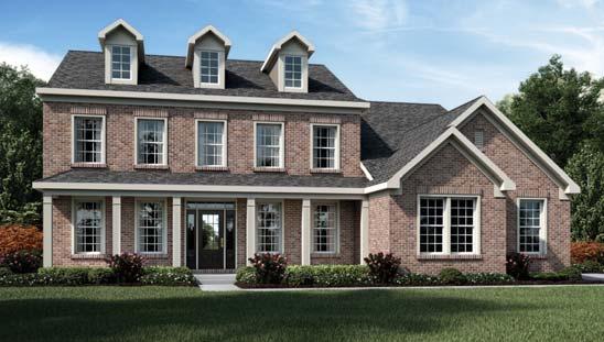
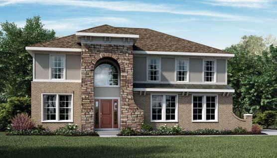
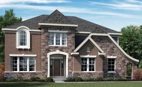
15 Year 2017 GEIST MANOR PUD Department (the "Approved Elevations"). The Illustrative Architectural Exhibit, attached hereto as Exhibit B, is a sampling and general representation of the approved home elevations. The Approved Elevations are hereby incorporated and approved. All homes shall be substantially consistent with the Approved Elevations or otherwise comply with the standards set forth in this Ordinance. The Director of Planning and Zoning the Community Development Department, including his/her designees, shall review and approve home elevations at the time of filing of the Building Permit for compliance. (b) If a home elevation does not comply with Section 1.04(D)(1)(a), then the proposed home elevation(s) shall be submitted for review and approval by the PUD Committee. The PUD Committee's review of the home elevation(s) shall be performed in order to determine its compatibility and consistency with the intended quality and character of the PUD and the Approved Elevations. (2) Article 5.13 AD-01 (A)(1)(b): Architectural Design; Single-Family Residential; Facade; Side and Rear Elevation shall not apply; rather, the following shall apply: (a) Dwellings on lots designated with a black circle on the Concept Plan shall: have masonry on all four sides, but, in all cases, shall include a minimum three (3) foot wainscot, and shall (i) have a minimum three (3') foot masonry wainscot on all four sides, and (ii) incorporate one (1) or more of the following features: rear sun room, rear screened porch, rear covered patio, or any other rear facade extension. (3) Article 5.13 AD-01 (A)(2): Architectural Design; Single-Family Residential; Facade; Exterior Material shall apply; however, aluminum, stucco, heavy-gauge vinyl, and vinyl shall not be permitted as a siding material. (4) Article 5.13 AD-01 (A)(3): Architectural Design; Single-Family Residential; Facade; Architectural Features shall apply, as modified below: (a) No more than one (1) architectural feature from Article 5.13 AD-01 (A)(3)(b): Architectural Design; Single-Family Residential; Facade; Architectural Features; Roof may be used to satisfy the requirements of Article 5.13 AD-01 (A)(1)(a): Architectural Design; Single-Family Residential; Facade; Masonry; Front Elevation. (b) In addition, The following shall be added to the list of architectural features, which shall be worth one (1) point unless indicated otherwise: (a) (i) More than one (1) siding profile on the front elevation (e.g., second siding profile such as shake, vertical or other horizontal siding used as an accent); (b) (ii) Large feature window on the second floor above the front door 3 ; (c) (iii) covered front porch; (d) (iv) having three (3) or more materials on the front facade; (e) (v) one (1) multi-window dormer; (f) (vi) at least a two-foot (2') deep offset at one (1) or more points along the front elevation; (g) (vii) Dentil blocks, decorative brackets, crown moulding or similar architectural detailing at eaves on front facade 3 ; or (h) (viii) Minimum three and a half inch (3 1/2") wide trim on all front facade windows (65) Article 5.13 AD-01 (A)(4): Architectural Design; Single-Family Residential; Dimensions shall not apply. Instead, the following shall apply: (a) A front-load garage door shall not exceed more than fifty percent (50%) of the front facade width. (5) Article 5.13 AD-01 (D): Architectural Design; Single-Family Residential; Automobile Storage shall apply. In addition, 3 Please see Exhibit E, Architectural Elements Examples 4 City of Fishers PUD District Ordinance
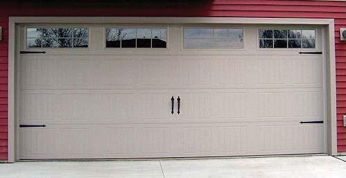
16 GEIST MANOR PUD City of Fishers PUD District Ordinance 5 Year 2017 (a) Decorative garage doors shall be required on all front-loading garages, as shown illustratively on the Decorative Garage Door Exhibit, attached hereto as Exhibit C. Other decorative garage doors also shall be permitted as long as the garage doors are substantially similar or greater in quality, character, and architectural detailing as the decorative garage doors shown on Exhibit C. (6) Article 5.13 AD-01 (D)(3): Architectural Design; Single-Family Residential; Automobile Storage; Minimum Garage Depth: shall apply, as modified below: (a) Minimum Garage Depth: Nineteen (19) feet. E. Density & Intensity Standards (DI): shall apply. F. Entrance & Driveway Standards (ED): shall apply. G. Environmental Standards (EN): shall apply. H. Fence & Wall Standards (FW): shall apply. I. Floodplain Standards (FP): shall apply. J. Floor Area Standards (FA): shall apply. K. Height Standards (HT): shall apply. L. Home Occupation Standards (HO): shall apply. M. Landscaping Standards (LA): shall apply. N. Lighting Standards (LT): shall apply. O. Loading Standards (LD): shall apply. P. Lot Standards (LO): shall apply. Q. Outdoor Storage Standards (OS): shall apply. R. Parking Standards (PK): shall apply. S. Pedestrian Accessibility Standards (PA): shall apply. T. Performance Standards (PF): shall apply. U. Permanent Outdoor Display Area Standards (PD): shall apply. V. Property Identification Standards (PI): shall apply. W. Public Art Standards (PT): shall apply. X. Public Improvement Standards (PV): shall apply. Y. Setback Standards (SB): shall apply. Z. Sewer & Water Standards (SW): shall apply. AA. Sexually Oriented Business Standards (SX): shall apply. BB. Sign Standards (SG): shall apply. CC. Structure Quantity Standards (SQ): shall apply. DD. Telecommunication Facilities Standards (TC): shall apply. EE. Temporary Use/Structure Standards (TU): shall apply. FF. Use-specific Standards (US): shall apply. GG. Vision Clearance Standards (VC): shall apply Design Standards (Area A only, except where Area B is noted) A. Cross References: The regulations of Article 7: Design Standards applicable to a Planned Unit Development (PUD) shall apply except as modified by this Ordinance: B. Access Road Standards (AC): shall apply. C. Alley Standards (AL): shall apply. D. Anti-monotony Standards (AM): shall apply. E. Common Area Standards (CA): shall apply. F. Covenant Standards (CE): shall apply. G. Dedication of Public Improvement Standards (DD): shall apply. H. Density and Intensity Standards (DE): shall apply.
17 Year 2017 GEIST MANOR PUD I. Development Name Standards (DN): shall apply. J. Easement Standards (EA): shall apply. K. Erosion Control Standards (EC): shall apply. L. Floodplain Standards (FL): shall apply. M. Lot Establishment Standards (LT): shall apply; except as modified below: (1) Article 7.18 LE-01 (B)(1): Lot Establishment Standards; Residential Lot Standards: Interior Street Frontage; shall not apply (21) Article 7.18 LE-01 (B)(3): Lot Establishment Standards; Residential Lot Standards: Corner Lots; shall not apply. Instead, the following shall apply: (a) Residential corner lots shall be at least twenty-five percent (25%) larger than the minimum lot area indicated for the zoning district. N. Mixed Use Development Standards (MU): shall apply. O. Monument & Marker Standards (MM): shall apply. P. On-street Parking Standards (OG): shall apply. Q. Open Space Standards (OP): shall apply. Per the UDO, a minimum of twenty-five percent (25%) Open Space shall be provided within the Real Estate. Per Article 7.25 OP-01(C)(6): Open Space Standards; Residential; City Council-Approved Open Space, Area B the open space shown on Exhibit D shall be deemed to satisfy the Open Space standards. R. Pedestrian Network Standards (PN): shall apply. S. Perimeter Landscaping Standards (PL): shall apply. T. Prerequisite Standards (PQ): shall apply. U. Storm Water Standards (SM): shall apply. V. Street & Right-of-way Standards (SR): shall apply; except as modified below: (1) Article 7.36 SR-01 (C)(3): Street and Right-of-way Standards: Residential: Street Design Principles: Connectivity; shall apply, except it shall not apply on the east side of the Real Estate (due to the topography and existing conditions). (2) Article 7.36 SR-01 (C)(11): Street and Right-of-way Standards: Residential: Street Design Principles: Cul-de-sac Length; shall not apply. Instead, the following shall apply: (a) The maximum cul-de-sac length shall be 1,050 feet. W. Street Lighting Standards (SL): shall apply. X. Street Name Standards (SN): shall apply. Y. Street Sign Standards (SS): shall apply. Z. Surety Standards (SY): shall apply. AA. Utility Standards (UT): shall apply Procedures A. The procedures set forth in Article 9: Processes, Permits & Fees; Planned Unit Development shall apply, as amended. Development plans shall be reviewed and approved based upon compliance with the development and design standards set forth herein. B. If applicable the Real Estate shall be assigned to the City's general PUD Committee (the "Committee") for architectural review. C. The Committee, if applicable, and the Mayor or Mayor's Designee shall have discretion and flexibility to consider and approve modifications pertaining to any development and design standards established or referenced by this Ordinance if the Committee or Mayor or Mayor's Designee determines such modifications are consistent with the intent of this Ordinance and consistent with the quality and character represented in this Ordinance. 6 City of Fishers PUD District Ordinance
18 GEIST MANOR PUD Year Commitments A. Pursuant to Article 9.18(J)(4): Planned Unit Development; PUD District Ordinance and Concept Plan; City Council; Commitments, certain commitments in the form substantially as attached hereto as Exhibit F (the "Commitments") shall be recorded by the owner of the Real Estate in the Office of the Recorder of Hamilton County, Indiana. The owner shall deliver a copy of the recorded instrument to the Planning and Zoning Department of the City of Fishers prior to applying for any subsequent permits for the Real Estate. City of Fishers PUD District Ordinance 7
 as approximately shown on the Tree Conservation Exhibit, attached hereto and incorporated herein shall be recorded.")
19 GEIST MANOR PUD Year Tree Conservation Easement A. A tree conservation easement ( Easement ) as approximately shown on the Tree Conservation Exhibit, attached hereto and incorporated herein shall be recorded. Within the Easement, no trees with a diameter at breast height ( DBH ) in excess of six inches (6 ) or evergreens eight feet (8 ) or more in height (the Protected Trees ) shall be removed unless the tree is damaged, diseased, dead, listed as Invasive and Poor Characteristic Species as per Ordinance C, as amended, or is required to be removed in order to comply with safety requirements of any governmental agency. If a Protected Tree is damaged or otherwise removed by the developer or builder, except as permitted to be removed as listed above, then the developer or builder (as the case may be) shall reestablish the Protected Tree with a tree or trees of combined equal or greater DBH subject to the availability of space for their healthy growth in the Easement under Ordinance C, as amended. It is acknowledged that certain areas of the woodlands will not be appropriate for the Easement due to drainage and utility needs and due to location of trails, paths, and related community amenities as will be identified at the time of the Detailed Development Plan. Florida Rd. 113 th St. North Park Tree Conserva on Easement City of Fishers PUD District Ordinance 8
20 GEIST MANOR PUD Year Adoption This ordinance shall be in full force and effect from and after its passage by the Common Council and after the occurrence of all other actions required by law. All provisions or parts of the UDO in conflict herewith are hereby repealed. APPROVED by the Common Council of the City of Fishers this day of, THE COMMON COUNCIL OF THE CITY OF FISHERS, HAMILTON COUNTY, INDIANA AYE NAY David C. George, President Todd P. Zimmerman, Vice-President C. Pete Peterson, Member John W. Weingardt, Member Eric Moeller, Member Selina M. Stoller, Member Richard W. Block, Member Cecilia C. Coble, Member Brad DeReamer, Member I hereby certify that the foregoing Ordinance was delivered to City of Fishers Mayor Scott Fadness on the day of 2017, at m. ATTEST: Jennifer L. Kehl, City Clerk MAYOR S APPROVAL Scott A. Fadness, Mayor Scott A. Fadness, Mayor MAYOR S VETO DATE DATE Approved by: Prepared by: 9 City of Fishers PUD District Ordinance Chris Greisl, City of Fishers, City Attorney Steven D. Hardin, Esq., Faegre Baker Daniels LLP, 600 East 96th Street, Suite 600, Indianapolis, Indiana (317) In accordance with Indiana Code, I affirm, under penalties for perjury, that I have taken reasonable care to redact each Social Security number in this document, unless required by law: India A.J.B.B. Olson
21 GEIST MANOR PUD Real Estate Year 2017 LOTS ONE (1), TWO (2), THREE(3) AND SIXTY-ONE (61) LUXHAVEN REVISED 1ST SECTION, RECORDED IN DEED RECORD J34, PAGE 211, IN THE RECORDER'S OFFICE OF HAMILTON COUNTY, INDIANA, ALSO, A PART OF THE NORTHEAST QUARTER OF SECTION 6, TOWNSHIP 17 NORTH, RANGE 6 EAST OF SECOND PRINCIPAL MERIDIAN, DESCRIBED AS FOLLOWS: BEGINNING AT THE QUARTER SECTION POST ON THE NORTH SIDE OF SECTION 6, THENCE EAST RODS, THENCE SOUTH 170 RODS, THENCE WEST RODS, THENCE NORTH 170 RODS TO THE PLACE OF BEGINNING, CONTAINING 90-1/2 ACRES, EXCEPT 1/2 ACRE FOR A GRAVEYARD. ALSO, WEST HALF OF THE SOUTHEAST QUARTER OF SECTION 6, TOWNSHIP 17 NORTH, RANGE 6 EAST OF SECOND PRINCIPAL MERIDIAN, EXCEPT COMMENCING AT THE NORTHWEST CORNER OF THE SOUTHEAST QUARTER OF SECTION 6, TOWNSHIP 17 NORTH, RANGE 6 EAST OF SECOND PRINCIPAL MERIDIAN, THENCE EAST 17 RODS AND 4 FEET; THENCE SOUTH 72 RODS; THENCE WEST 17 RODS AND 4 FEET, THENCE NORTH 72 RODS TO THE PLACE OF BEGINNING, CONTAINING 8 ACRES, MORE OR LESS, ALSO EXCEPT LUXHAVEN ADDITION, AS SHOWN IN DEED RECORD 131, PAGE 291. EXCEPTING: PART OF THE NORTHEAST QUARTER OF SECTION 6, TOWNSHIP 17 NORTH, RANGE 6 EAST, LOCATED IN FALL CREEK TOWNSHIP, HAMILTON COUNTY, INDIANA, DESCRIBED AS FOLLOWS: COMMENCING AT THE RAILROAD SPIKE AT THE NORTHWEST CORNER OF THE NORTHEAST QUARTER OF SECTION 6, TOWNSHIP 17 NORTH, RANGE 6 EAST; THENCE NORTH 89 DEGREES 27 MINUTES 13 SECONDS EAST FEET TO A STONE WITH CUT X AT THE SOUTHWEST CORNER OF THE SOUTHEAST QUARTER OF SECTION 31, TOWNSHIP 18 NORTH, RANGE 6 EAST; THENCE NORTH 89 DEGREES 20 MINUTES 15 SECONDS EAST FEET ALONG THE NORTH LINE OF SAID NORTHEAST QUARTER TO A 5/8 INCH IRON ROD WITH YELLOW CAP STAMPED MILLER SURVEYING AT THE POINT OF BEGINNING OF THIS DESCRIPTION; THENCE NORTH 89 DEGREES 10 MINUTES 15 SECONDS EAST FEET ALONG SAID NORTH LINE TO A 5/8 INCH IRON ROAD WITH YELLOW CAP STAMPED MILLER SURVEYING AT THE NORTHEAST CORNER OF A 90.5 ACRE TRACT OF REAL ESTATE DESCRIBED IN INSTRUMENT NUMBER (SAID 5/8 INCH IRON ROD WITH YELLOW CAP STAMPED MILLER SURVEYING ALSO BEING THE NORTHWEST CORNER OF THE ACRE TRACT OF REAL ESTATE DESCRIBED IN INSTRUMENT NUMBER ); THENCE SOUTH 00 DEGREES 45 MINUTES 09 SECONDS WEST FEET ALONG THE COMMON BOUNDARY BETWEEN THE ABOVE TWO TRACTS TO A MAG NAIL AT THE SOUTHWEST CORNER OF SAID TRACT OF REAL ESTATE DESCRIBED IN INSTRUMENT NUMBER ; THENCE SOUTH 85 DEGREES 04 MINUTES 44 SECONDS WEST FEET ALONG THE CENTERLINE OF l13th STREET TO A MAG NAIL; THENCE NORTH 00 DEGREES 45 MINUTES 09 SECONDS EAST FEET TO THE POINT OF BEGINNING, CONTAINING ACRES MORE OR LESS. ALSO EXCEPT TRACT ONE: THIRTY (30) FEET OFF THE WEST SIDE OF LOT NUMBER SIXTY-TWO (62) IN LUXHAVEN AMENDED 1ST SECTION, AN ADDITION IN HAMILTON COUNTY, INDIANA. TRACT TWO: PART OF THE SOUTHEAST QUARTER OF SECTION 6, TOWNSHIP 17 NORTH, RANGE 6 EAST, IN HAMILTON COUNTY, INDIANA, AND DESCRIBED AS FOLLOWS: PARTS OF LOTS 75, 76, 77, 78, 79,80, 81 AND 82 IN LUXHAVEN, AN ADDITION IN HAMILTON COUNTY, INDIANA, AND City of Fishers PUD District Ordinance 10
22 GEIST MANOR PUD Year 2017 MORE PARTICULARLY DESCRIBED AS FOLLOWS: BEGINNING AT A POINT ON THE WEST LINE OF SAID QUARTER SECTION, 256 FEET SOUTH OF THE NORTHWEST CORNER OF SAID QUARTER SECTION; THENCE EAST AND PARALLEL TO THE NORTH LINE OF SAID QUARTER SECTION 295 FEET; THENCE SOUTH AND PARALLEL TO SAID WEST LINE OF SAID QUARTER SECTION TO THE NORTH LINE OF MARTHA STREET AS SHOWN ON THE PLAT OF LUXHAVEN AMENDED 1ST SECTION; THENCE WEST ALONG THE NORTH LINE OF SAID MARTHA STREET 295 FEET TO THE WEST LINE OF SAID QUARTER SECTION; THENCE NORTH ALONG SAID WEST LINE TO THE PLACE OF BEGINNING. TRACT THREE: PART OF THE SOUTHEAST QUARTER OF SECTION 6, TOWNSHIP I 7 NORTH, RANGE 6 EAST, IN HAMILTON COUNTY, INDIANA, AND DESCRIBED AS FOLLOWS: ALL OF LOTS 153 TO 166 INCLUSIVE IN LUXHAVEN, AN ADDITION IN HAMILTON COUNTY, INDIANA, AND MORE PARTICULARLY DESCRIBED AS FOLLOWS: BEGINNING AT A POINT ON THE WEST LINE OF SAID QUARTER SECTION 1428 FEET SOUTH OF THE NORTHWEST CORNER THEREOF; THENCE EAST ALONG THE SOUTH LINE OF MARTHA STREET AS SHOWN ON THE PLAT OF LUXHAVEN AMENDED 1ST SECTION 465 FEET TO THE WEST LINE OF LOT 125 IN LUXHAVEN AMENDED 1ST SECTION; THENCE SOUTH ALONG SAID WEST LINE 200 FEET; THENCE WEST AND PARALLEL TO THE SOUTH LINE OF SAID MARTHA STREET 465 FEET TO THE WEST LINE OF SAID QUARTER SECTION; THENCE NORTH ALONG SAID WEST LINE 200 FEET TO THE PLACE OF BEGINNING. TRACT FOUR: ALL THAT PART OF SAID QUARTER SECTION LYING SOUTH OF THE ADDITION KNOWN AS LUXHAVEN AND LUXHAVEN AMENDED 1ST SECTION, AND MORE PARTICULARLY DESCRIBED AS FOLLOWS: BEGINNING AT A POINT ON THE WEST LINE OF SAID QUARTER SECTION 1628 FEET SOUTH OF THE NORTHWEST CORNER THEREOF; THENCE CONTINUING SOUTH ALONG SAID WEST LINE FEET TO THE SOUTHWEST CORNER OF SAID QUARTER SECTION; THENCE EAST ALONG THE SOUTH LINE THEREOF FEET TO A CONCRETE POST: THENCE NORTH AND PARALLEL TO THE WEST LINE OF SAID QUARTER SECTION FEET TO A POINT ON THE SOUTHERN LINE OF SAID LUXHAVEN AMENDED I ST SECTION; THENCE SOUTHWESTERLY ON AND ALONG THE SOUTHERN LINES OF LOTS 105 TO 111, INCLUSIVE, OF LUXHAVEN AMENDED 1ST SECTION TO THE SOUTHWEST CORNER OF LOT 111; THENCE SOUTHWESTERLY ON AND ALONG THE SOUTHERN ON AND ALONG THE SOUTHERN LINES OF LOTS 112 TO 124, INCLUSIVE OF LUXHAVEN AMENDED l ST SECTION TO THE SOUTHWEST CORNER OF LOT 124; THENCE WEST FEET TO THE PLACE OF BEGINNING, AND ALSO ALL THOSE PARTS OF MARTHA STREET; VAUGHN STREET AND LEWIS STREET WHICH ARE OR MAY BE A PART OF THE REAL ESTATE ABOVE DESCRIBED. 11 City of Fishers PUD District Ordinance


23 Exhibit A- Concept Plan Exhibit Area A Florida Rd. 113 th St. Area B Park North


24 Exhibit B - Illustrative Architectural Exhibit


25 Exhibit B - Illustrative Architectural Exhibit (cont.)

26 Exhibit C - Decorative Garage Door Exhibit


27 Exhibit C - Decorative Garage Door Exhibit
28 Exhibit D - Open Space Exhibit Florida Rd. Open Space 113 th St. Park North


29 Exhibit E - Architectural Elements Examples Large Feature Window


30 Exhibit E - Architectural Elements Examples Decorative Brackets


31 Exhibit E - Architectural Elements Examples Dentil Blocks


32 Exhibit E - Architectural Elements Examples Architectural Detailing


33 Exhibit E - Architectural Elements Examples Crown Moulding
34 Exhibit F - Commitments COMMITMENTS CONCERNING THE USE AND DEVELOPMENT OF REAL ESTATE Mann Properties, LLC (the Developer ), makes the following commitments to the Common Council ( Council ) for the City of Fishers, Hamilton County, Indiana ( City ) in connection with the use and development of real estate generally located at or about 0 East 113 th Street, Fishers, Indiana ( Real Estate ): WHEREAS, on or around September 6, 2017, the City s Advisory Plan Commission held a public hearing concerning a planned unit development for the Real Estate ( Geist Manor PUD ) and sent a favorable recommendation to the Council for its review of the Geist Manor PUD; WHEREAS, the purpose of the Geist Manor PUD is to encourage improved design in the development of land by promoting greater flexibility in applying the City of Fishers Unified Development Ordinance ( UDO ) to the development of the Real Estate; WHEREAS, as a condition to approving the Geist Manor PUD, Ordinance No E, (the PUD Ordinance ) the City seeks various commitments by the Developer as further defined herein ( Commitments ); and WHEREAS, Developer now desires to make various Commitments to further enhance the Real Estate. NOW, THEREFORE, Developer hereby declares that the following Commitments which shall be recorded and effective as an obligation and commitment running with the Real Estate. Section 1. Description of Real Estate. See Exhibit A, attached hereto and incorporated herein by reference, which shall be the legal description of Area A as depicted in the PUD Ordinance (the Description ). The Description shall be attached hereto and these Commitments recorded at the time the plat is recorded as described in Section 2(C), below. Section 2. Statement of Commitments to the City. Developer hereby makes the following binding Commitments regarding the Real Estate: A. Annexation. Developer hereby agrees to not remonstrate against annexation of the Real Estate by the City. If the Real Estate has not been annexed prior to Developer s first sale of a residential lot within the Real Estate, then Developer shall include a waiver of remonstrance provision in the covenants and restrictions for the Real Estate, which shall be recorded and provided to the purchaser of each lot with the Real Estate. Once the City achieves contiguity with the Real Estate, as defined by Ind. Code , Developer, at no cost to itself, shall voluntarily annex the Real Estate into the City of Fishers. B. Payment of Impact Fees. Developer hereby agrees that, prior to the formal annexation of the Real Estate to the City, any home constructed on the Real Estate shall voluntarily contribute to the City the standard Impact Fees, as further defined by Chapter 156 of the
35 City s Code of Ordinances, normally assessed by the City for a single-family home at the time a building permit is issued. C. Platting of Real Estate. Within thirty (30) days after acquiring the Real Estate, Developer shall file for a primary plat of the Real Estate in accordance with the City s UDO. Developer s plat (the Plat ) shall show that portion of Parcel No: , and the entirety of Parcel No: , Parcel No: , Parcel No: , Parcel No: , and Parcel No: being dedicated to the City pursuant to the Purchase and Park Impact Fee Credit Agreement by and between the City and Sue L. Ciott, Trustee of Sue L. Ciotti Revocable Trust & Herbert A. Miller, Trustee of Herbert A. Miller Revocable Trust, as a separate parcel as further depicted in Exhibit B, attached hereto and incorporated herein by reference. Section 3. Binding Effect. These commitments are binding upon Developer, each subsequent owner of the Real Estate, and each other person acquiring an interest in the Real Estate, unless modified or terminated. Except as provided in Section 7, below, these commitments may be modified or terminated only by a decision of the Fishers City Council following a public hearing held by the Fishers Advisory Plan Commission wherein notice has been given as provided by the Rules of and Procedures of the Fishers Advisory Plan Commission. Section 4. Effective Date. The Commitments contained herein shall be in full force and effect upon execution. Section 5. Recording. The undersigned hereby authorizes the City to record these Commitments in the Office of the Recorder of Hamilton County, Indiana. Section 6. Enforcement. These Commitments may be enforced by the City and its bodies. Section 7. Termination Upon Satisfaction of Commitments. Once the Real Estate has been annexed into the City and the Plat has been Recorded, then: (a) the City and Developer expressly agree that these Commitments shall be deemed terminated and of no further force and effect; and (b) Developer and City agree to promptly execute and record a Termination of Commitments to that effect. IN WITNESS WHEREOF, Mann Properties, LLC, has caused these commitments to be executed as of this day of, [SIGNATURES ON FOLLOWING PAGE]
36 Mann Properties, LLC ( Developer ) By: Its: STATE OF INDIANA ) ) SS: COUNTY OF HAMILTON ) Before me the undersigned, a Notary Public in and for said County and State, personally appeared of Mann Properties, LLC, who having been duly sworn acknowledged the execution of the foregoing Commitments. Witness my hand and Notarial Seal this day of, 2017 My Commission Expires: Notary Public Printed Name Residing in County, Indiana
37 CITY OF FISHERS By: David George, Common Council President ATTEST: Jennifer L. Kehl, City Clerk This instrument prepared by: Christopher P. Greisl, City Attorney, City of Fishers, Hamilton County, Indiana, One Municipal Drive, Fishers, Indiana In accordance with Indiana Code, I affirm, under penalties for perjury, that I have taken reasonable care to redact each Social Security Number in this document, unless required by law: /s/ Christopher P. Greisl, Esq.
38 EXHIBIT A [Legal description for Area A to be inserted at later date]

39 EXHIBIT B
Year. Simply Dental PUD. Town of Fishers Planned Development Ordinance No v
 Simply Dental PUD v. 02.03.14 Town of Fishers Planned Development Ordinance No. 010614 1.01 Declaration, Purpose and Intent, and Permitted Uses Declaration Ordinance No. 010614 (this Ordinance") Adopted:
ORDINANCE NO. AN ORDINANCE AMENDING THE ZONING ORDINANCE OF FISHERS, INDIANA 2006
 ORDINANCE NO. AN ORDINANCE AMENDING THE ZONING ORDINANCE OF FISHERS, INDIANA 2006 AN ORDINANCE AMENDING THE ZONING ORDINANCE OF FISHERS, INDIANA 2006. BE IT ORDAINED BY THE TOWN COUNCIL OF THE TOWN OF
COLLEGE PARK CHURCH. Avalon PUD. Text Amendment PRESENTED BY STEVEN D. HARDIN, ESQ. COLLEGE PARK CHURCH, INC.
 COLLEGE PARK CHURCH Avalon PUD Text Amendment COLLEGE PARK CHURCH, INC. PRESENTED BY STEVEN D. HARDIN, ESQ. City Council Request for 2nd & 3rd Reading January 19, 2015 TABLE OF CONTENTS Pond Right of Way
ANDERSON HALL PUD TEXT AMENDMENT PRESENTED BY STEVEN D. HARDIN, ESQ.
 ANDERSON HALL PUD TEXT AMENDMENT PRESENTED BY STEVEN D. HARDIN, ESQ. TOWN COUNCIL REQUEST FOR THIRD READING MARCH 17, 2014 TABLE OF CONTENTS 141ST STREET & PROMISE ROAD PUD Petitioner Craig H. Lintner
Subdivision, Development Plan and PUD Design Standards Porter County Unified Development Ordinance
 Chapter Subdivision, Development Plan and PUD Design Standards Porter County Unified Development Ordinance 20 Bradley E. Johnson, AICP website www.groundrulesinc.com Design Standards Section Name Page
Chapter. Subdivision Regulations Porter County Unified Development Ordinance. website Bradley E.
 Subdivision Regulations Porter County Unified Development Ordinance 2007 Bradley E. Johnson, AICP website www.groundrulesinc.com Conventional Subdivision (CV) 6.01 Conventional Subdivision Intent The Conventional
ORDINANACE NO
 ORDINANACE NO. 082018 AN ORDINANCE ADJUSTING RATES AND CHARGES FOR THE USE OF AND SERVICES RENDERED BY THE CITY OF FISHERS, INDIANA STORMWATER UTILITY SYSTEM WHEREAS, the City of Fishers, Hamilton County,
FLATS AT 146. Replat and Amendment to a Multi-family Planned Development DOMO DEVELOPMENT, LLC PRESENTED BY STEVEN D. HARDIN, ESQ.
 Replat and Amendment to a Multi-family Planned Development DOMO DEVELOPMENT, LLC PRESENTED BY STEVEN D. HARDIN, ESQ. NOBLESVILLE PLAN COMMISSION JUNE 16, 2014 TABLE OF CONTENTS Petitioner DOMO Development
Article. Table of Contents City of Birmingham Zoning Ordinance. 2006, Bradley E. Johnson, AICP
 00 Table of Contents City of Birmingham Zoning Ordinance 2006, Bradley E. Johnson, AICP Table of Contents One: Zoning Ordinance Foundation Page # 1.01 Title... 1-2 1.02 Defined Words... 1-2 1.03 Authority...
ORDINANCE NO. 208 BE IT ORDAINED BY THE CITY COUNCIL OF THE CITY OF UNIVERSITY HEIGHTS, JOHNSON COUNTY, IOWA:
 ORDINANCE NO. 208 AN ORDINANCE AMENDING ORDINANCE NO. 79 (ZONING) TO CREATE A COMMERCIAL HOTEL ZONE AND PERMIT DEVELOPMENT PURSUANT TO A COMMERCIAL HOTEL PUD BE IT ORDAINED BY THE CITY COUNCIL OF THE CITY
APPLICATION PROCEDURES FOR A PLAT AMENDMENT OR REVISION
 APPLICATION PROCEDURES FOR A PLAT AMENDMENT OR REVISION DEFINITION: Any revision or amendment to an approved recorded or unrecorded final plat. A revision (not recorded) does not require a public hearing
PLANNED DEVELOPMENT DISTRICT STANDARDS. Cadence Site
 PLANNED DEVELOPMENT DISTRICT STANDARDS Cadence Site A Planned Development District 1. Statement of General Facts, Conditions and Objectives Property Size: Approximately 57.51 Acres York County Tax Map
PERSIMMON GROVE. Developer Pulte Group North Meridian Street, Suite 530 Carmel, IN 46032
 PERSIMMON GROVE A RESIDENTIAL PLANNED UNIT DEVELOPMENT In Avon, Indiana Developer Pulte Group 11590 North Meridian Street, Suite 530 Carmel, IN 46032 Attorney Comer Law Office Ben Comer 71 West Marion
CITY OF SARATOGA SPRINGS ZONING ORDINANCE
 Appendix C: 8. The Village At Saratoga Planned Unit Development (formerly 241.8) Chapter 241.8 AN ORDINANCE PROVIDING FOR THE ESTABLISHMENT OF A PLANNED UNIT DEVELOPMENT DISTRICT TO BE KNOWN AS "THE VILLAGE
PLANNING DIRECTOR. Approved by the Planning Director on this day of, A.D. 20. day of, A.D. 20. Approved by the Fire Chief on this
 Located in a portion of the West Half of Section 19, Township 5 South, Range 1 East, Salt Lake Base and Meridian. SURVEYOR'S CERTIFICATE I, the undersigned surveyor, do hereby certify that I am a registered
TOWNSHIP OF ALGOMA COUNTY OF KENT, MICHIGAN. Minutes of a regular meeting of the Township Board of the Township of Algoma, Kent
 Site Plan No. 0410 --- TOWNSHIP OF ALGOMA COUNTY OF KENT, MICHIGAN Minutes of a regular meeting of the Township Board of the Township of Algoma, Kent County, Michigan, held in the Algoma Township Hall,
APPLICATION PROCEDURES FOR A MAJOR SUBDIVISION PRELIMINARY PLAT
 APPLICATION PROCEDURES FOR A DEFINITION: The subdivision of a tract of land into at least three (3) residential, commercial, or industrial parcels, including the remainder of the original parcel, fronting
FINAL PLAT. Community Development Department 8101 Ralston Road Arvada, Colorado 80002
 FINAL PLAT Community Development Department 8101 Ralston Road Arvada, Colorado 80002 September 2015 FINAL SUBDIVISION PLAT Final Subdivision Plat Review Applications for a Final Plat shall be submitted
NON-EXCLUSIVE ROADWAY AND UTILITY EASEMENT DEED AND AGREEMENT
 RETURN TO: STOGSDILL LAW OFFICE, P.C. 505 West Main, Suite 313 Lewistown, Montana 59457 (406) 538-2623 NON-EXCLUSIVE ROADWAY AND UTILITY EASEMENT DEED AND AGREEMENT THIS EASEMENT DEED AND AGREEMENT is
ORDINANCE NO BROWNSBURG, INDIANA, 2014
 ORDINANCE NO. 2013-33 BROWNSBURG, INDIANA, 2014 AN ORDINANCE TO AMEND ARTICLES 1, 2, 4, 5, 7, AND 9, 1.01 (I)(1) ZONING ORDINANCE, 1.03 (B) LOCATION, 1.04 PLAN COMMISSION CERTIFICATION, 1.05 TOWN COUNCIL
JOINT ORDINANCE CITY OF WINCHESTER, KENTUCKY ORDINANCE NO CLARK COUNTY, KENTUCKY, ORDINANCE NO SUMMARY
 JOINT ORDINANCE CITY OF WINCHESTER, KENTUCKY ORDINANCE NO. 17-2014 CLARK COUNTY, KENTUCKY, ORDINANCE NO. 2004-18 SUMMARY AN ORDINANCE ENACTED JOINTLY BY CLARK COUNTY/CITY OF WINCHESTER, KENTUCKY AMENDING
The Drainage Encroachment Agreement has been revised as of August 2014.
 Vanderburgh County Surveyor s office Linda Freeman Jeff Mueller, PE, County Surveyor Doug McDonald, PE, LS Chief Deputy Special Deputy The Drainage Encroachment Agreement has been revised as of August
Modification of Commitments & PUD Text Amendment
 STEEPLECHASE PUD Modification of Commitments & PUD Text Amendment PRESENTED BY STEVEN D. HARDIN, ESQ. REQUEST FOR COMBINED 2ND & 3RD READING REGARDING MODIFICATION OF COMMITMENTS & PUD TEXT AMENDMENT OCTOBER
MIXED USE DEVELOPMENT AGREEMENT
 MIXED USE DEVELOPMENT AGREEMENT THIS MIXED USE DEVELOPMENT AGREEMENT (hereinafter "Agreement") made and entered into this day of, 2007, pursuant to Section 205-30 of the Zoning Ordinances of the City of
MSC Ridgewood Subdivision
 Ay' MSC 2011 12523 CERTIFICATE OF RECORD STATE OF ARKANSAS cowl, I of WHITE CERTIFY THAT THIS INSTRUMENT WAS FILED FOR RECORD AN,D IS RECORDED AS STAMPED HEREON. DATE a - 3- I The. 1: mspry) BOOK Bill
DECLARATION OF RESTRICTIONS AND EASEMENTS OF OAKWOOD MEADOWS SUBDIVISION
 DECLARATION OF RESTRICTIONS AND EASEMENTS OF OAKWOOD MEADOWS SUBDIVISION WHEREAS, OAKWOOD MEADOWS, a subdivision of part of the Southwest quarter of Section 24, Town 1 North, Range 6 East, Green Oak Township,
ORDINANCE NO. O-5-10
 ORDINANCE NO. O-5-10 AN ORDINANCE OF THE TOWN COMMISSION OF THE TOWN OF PALM BEACH SHORES, FLORIDA, AMENDING THE TOWN CODE OF ORDINANCES AT APPENDIX A. ZONING. SECTION VI. DISTRICT B REGULATIONS BY AMENDING
AN ORDINANCE TO REZONE A CERTAIN PARCEL OF LAND IN THE CITY OF MOUNTAIN BROOK, ALABAMA FROM RESIDENCE C DISTRICT TO LOCAL BUSINESS DISTRICT
 ORDINANCE NO. 1904 AN ORDINANCE TO REZONE A CERTAIN PARCEL OF LAND IN THE CITY OF MOUNTAIN BROOK, ALABAMA FROM RESIDENCE C DISTRICT TO LOCAL BUSINESS DISTRICT WHEREAS, after due consideration, the City
PUD Preliminary Plan/Plat Information & Application Packet
 Village of Lemont 418 Main Street Lemont, Illinois 60439 phone 630-257-1595 fax 630-257-1598 PUD Preliminary Plan/Plat Information & Application Packet Introduction This information packet was created
Charter Township of Plymouth Zoning Ordinance No. 99 Page 200 Article 20: Schedule of Regulations
 Charter Township of Plymouth Zoning Ordinance No. 99 Page 200 ARTICLE XX SCHEDULE OF REGULATIONS SEC. 20.1 HEIGHT, AREA, LOT COVERAGE, YARD REQUIREMENTS AND FLOOR AREA (as amended /25/07) ZONG DISTRICT
Article. Table of Contents Town of Fishers Unified Development Ordinance. 2013, Bradley E. Johnson, AICP
 00 Table of Contents Town of Fishers Unified Development Ordinance 2013, Bradley E. Johnson, AICP Table of Contents 00 1: Ordinance Foundation 1.01 Title... 1-2 1.02 Defined Words... 1-2 1.03 Authority...
Community Development Department Council Chambers, 7:30 PM, July 20, 2017
 STAFF REPORT 2017-25P: Subdivision Community Development Department Council Chambers, 7:30 PM, July 20, 2017 To: From: Re: Paul Luke, Chairman, Skokie Plan Commission Mike Voitik, Planning Technician 2017-25P:
PINE CANYON PD ZONING REGULATIONS
 Review Notes: Green highlight = blanks to be completed before recording. 1. DEFINITIONS For purposes of the PD Plan and these Zoning Regulations: (1) capitalized terms used but not defined in the PD Plan
DEVELOPMENT DEPARTMENT STAFF REPORT THE PARK AT 5 TH
 DEVELOPMENT DEPARTMENT STAFF REPORT ARB Meeting Date: July 3, 2018 Item #: _PZ2018-293_ THE PARK AT 5 TH Request: Site Address: Project Name: Parcel Number: Applicant: Proposed Development: Current Zoning:
PREPARED BY PLANNING DEPARTMENT ORANGE COUNTY NORTH CAROLINA
 PREPARED BY PLANNING DEPARTMENT ORANGE COUNTY NORTH CAROLINA Return to: DONNA PUCKETT 1555 NC 56 SUITE 2 CREEDMOOR, NC 27522 DECLARATION OF DEVELOPMENT RESTRICTIONS AND REQUIREMENTS RECORDED CONCURRENTLY
Cross Reference: Instrument No. A State Parcel No Parcel: TEMPORARY CONSTRUCTION EASEMENT AGREEMENT
 Cross Reference: Instrument No. A199500066899 Project: 92TU000128 State Parcel No. 49-07-18-107-004.000-801 Parcel: 8033304 Date: Version: TEMPORARY CONSTRUCTION EASEMENT AGREEMENT THIS TEMPORARY CONSTRUCTION
AN ORDINANCE TO AMEND SECTION OF THE RAPID CITY MUNICIPAL CODE TO ALLOW FOR ADMINISTRATIVE DISSOLUTION OF PLANNED DEVELOPMENTS
 Ordinance No. 6231 AN ORDINANCE TO AMEND SECTION 17.50.050 OF THE RAPID CITY MUNICIPAL CODE TO ALLOW FOR ADMINISTRATIVE DISSOLUTION OF PLANNED DEVELOPMENTS WHEREAS, the City of Rapid City has adopted a
Condominium Unit Requirements.
 ARTICLE 19 CONDOMINIUM REGULATIONS Section 19.01 Purpose. The purpose of this Article is to regulate projects that divide real property under a contractual arrangement known as a condominium. New and conversion
BYRON TOWNSHIP ZONING APPLICATION
 BYRON TOWNSHIP ZONING APPLICATION Phone: (616) 878-9104 * Fax: (616) 878-3980 * Website: www.byrontownship.org This application will not be accepted if incomplete. APPLICATION FOR & REQUIRED COPIES Private
Staff Report: Date: Applicant: Property Identification: Acreage of Request: Current Zoning of Requested Area: Requested Action: Attached:
 Staff Report: Completed by Jeff Palmer Director of Planning & Zoning Date: November 7, 2018, Updated November 20, 2018 Applicant: Greg Smith, Oberer Land Developer agent for Ronald Montgomery ET AL Property
PLANNED DEVELOPMENT DISTRICT A ACRE TRACT KNOWN AS GEAN ESTATES CITY OF KELLER, TARRANT COUNTY TEXAS
 PLANNED DEVELOPMENT DISTRICT A 123.359 ACRE TRACT KNOWN AS GEAN ESTATES CITY OF KELLER, TARRANT COUNTY TEXAS A. Exhibit A Development Regulations B. Exhibit B Legal Description C. Exhibit C Conceptual
CHAPTER 8. REVISION HISTORY
 CHAPTER 8. REVISION HISTORY CHAPTER 8. RESIDENTIAL DISTRICTS Ordinance # Plan Commission Town Council Approval Date Adoption Date Description 2002-14 09-24-02 11-14-02 Adoption of Chapter 8. 2010-20 09-27-10
GREENWAY EASEMENT AGREEMENT
 GREENWAY EASEMENT AGREEMENT This greenway access easement is entered into by and between the Laramie County School District Number One ( Grantor ), a corporate body organized under the laws of the State
Foreword. Table of Contents Porter County Unified Development Ordinance. website Bradley E.
 Table of Contents Porter County Unified Development Ordinance 2007 Bradley E. Johnson, AICP website www.groundrulesinc.com ii Porter County, Indiana Unified Development Ordinance Table of Contents Chapter
Exhibit "A" have applied for a re-zoning and re-classification of that property from OPEN RURAL (OR) to that of a PLANNED UNIT DEVELOPMENT (PUD); and
 to that of a PLANNED UNIT DEVELOPMENT (PUD); and") I NSTR # 200632845 OR BK 61439 PGS 0728-0750 RECORDED 06/24/2066 12:25:50 PR JOHN Q. CRAWFOKD CLERK OF CIRCUIT COURT NASSAU COUNTY, FLORIDA RECORDING FEES 1.37.80 ORDINANCE NO. 2006-65 AN ORDINANCE AMENDING
I NSTR # 200632845 OR BK 61439 PGS 0728-0750 RECORDED 06/24/2066 12:25:50 PR JOHN Q. CRAWFOKD CLERK OF CIRCUIT COURT NASSAU COUNTY, FLORIDA RECORDING FEES 1.37.80 ORDINANCE NO. 2006-65 AN ORDINANCE AMENDING
WILTON MANORS, Island City 2020 WILTON DRIVE, WILTON MANORS, FLORIDA 33305
 WILTON MANORS, Island City 2020 WILTON DRIVE, WILTON MANORS, FLORIDA 33305 COMMUNITY DEVELOPMENT SERVICES (954) 390-2180 FAX: (954) 567-6069 PLAT APPLICATION PACKAGE This package includes: General Submittal
Washington County, Minnesota Ordinances
 Washington County, Minnesota Ordinances Ordinance No. 153 Text Amendment to the Washington County Development Code - Chapter One, Section 2 and Chapter Two, Part 1, Part 2, Part 3, of the Development Code
ARTICLE 15 - PLANNED UNIT DEVELOPMENT
 Section 15.1 - Intent. ARTICLE 15 - PLANNED UNIT DEVELOPMENT A PUD, or Planned Unit Development, is not a District per se, but rather a set of standards that may be applied to a development type. The Planned
PUD 42 - Warner Ranch PUD - Amend. 2 Item No. 4B ZONING ZON
 PUD 42 - Warner Ranch PUD - Amend. 2 Item No. 4B ZONING ZON1210-001 CASE PLANNER: Steve Hopkins REQUEST: Approval of PUD 42 - Warner Ranch PUD - Amend. 2 ZONING AT TIME OF APPLICATION: PUD 42 CURRENT USE
ABBREVIATION LEGEND SITE INFORMATION:
 SITE INFORMATION: Current Zone: R-3 PUD, governed by Fox Hollow 2nd MDA Basis of Elevations: Northeast Corner of Section 13, T6S, R1W, S.L.B. & M Elevation: 4599.26 (Benchmark) ABBREVIATION LEGEND Owners:
CITY OF INDIANAPOLIS GRANT OF PERPETUAL DRAINAGE EASEMENT AND RIGHT-OF-WAY
 CROSS REFERENCE TO DEED#: PROJECT #: DRN - INSTRUMENT NO.: PARCEL #: CITY OF INDIANAPOLIS GRANT OF PERPETUAL DRAINAGE EASEMENT AND RIGHT-OF-WAY THIS INDENTURE made this day of, 20, by and between, ("GRANTOR")
Honorable Mayor Bill Agan and members of the Richland Hills City Council. Final Plat Richland Hills, Lots 1 & 2, Block 1 Brumlow Addition
 2B - 1 Memorandum To: From: Date: Subject: Honorable Mayor Bill Agan and members of the Richland Hills City Council Jason Moore, Assistant City Manager January 17, 2017 Final Plat Richland Hills, Lots
Article 7: Residential Land Use and Development Requirements
 Article 7: Residential Land Use and Section 701: Statement of Intent (A) (B) (C) The intent of Article 7 is to develop certain land use and development requirements for the residential uses within Cumru
AMENDED DECLARATION OF COVENANTS FOR COUNTRY CREEK SUBDIVISION
 AMENDED DECLARATION OF COVENANTS FOR COUNTRY CREEK SUBDIVISION THIS AMENDED DECLARATION OF COVENANTS, made this 17th day of February, 2004, by Frontier Land Company, an Indiana corporation (hereinafter
RESOLUTION NO. RESOLUTION APPROVING ZONING PETITION 84-71, Special Exception. WHEREAS, the Board of County Commissioners, as the governing
 /. ;C- C, i RESOLUTION NO. R-@+-l2?8 RESOLUTION APPROVING ZONING PETITION 84-71, Special Exception WHEREAS, the Board of County Commissioners, as the governing body, pursuant to the authority vested in
CHARTER TOWNSHIP OF CALEDONIA COUNTY OF KENT, MICHIGAN. at the Township and Village Hall, 8196 Broadmoor Avenue, Caledonia, Michigan on the
 First Reading CHARTER TOWNSHIP OF CALEDONIA COUNTY OF KENT, MICHIGAN At a regular meeting of the Township Board of the Charter Township of Caledonia, held at the Township and Village Hall, 8196 Broadmoor
CHAPTER 26 PLANNING AND ZONING ARTICLE VII. MOBILE HOMES AND RECREATIONAL VEHICLE (RV) PARKS. Recreational Vehicle (RV) Park Development Standards
 PARKS. Recreational Vehicle (RV) Park Development Standards") CHAPTER 26 PLANNING AND ZONING ARTICLE VII. MOBILE HOMES AND RECREATIONAL VEHICLE (RV) PARKS. Section 26-VII-1. Section 26-VII-2. Section 26-VII-3. Section 26-VII-4. Section 26-VII-5. Purpose Permitted
CHAPTER 26 PLANNING AND ZONING ARTICLE VII. MOBILE HOMES AND RECREATIONAL VEHICLE (RV) PARKS. Section 26-VII-1. Section 26-VII-2. Section 26-VII-3. Section 26-VII-4. Section 26-VII-5. Purpose Permitted
ORDINANCE NO
 APPROVED BY ORANGE COUNTY BOARD OF COUNTY COMMISSIONERS BCC Mtg. Date: May 24, 2016 EFFECTIVE DATE June 1, 2016 ORDINANCE NO. 2016-10 AN ORDINANCE AFFECTING THE USE OF LAND IN ORANGE COUNTY, FLORIDA; AMENDING
ELK RAPIDS TOWNSHIP ANTRIM COUNTY, MICHIGAN ORDINANCE NO
 ELK RAPIDS TOWNSHIP ANTRIM COUNTY, MICHIGAN ORDINANCE NO. 3-2011 AN ORDINANCE TO REPLACE THE SUBDIVISION CONTROL ORDINANCE WITH A NEW SUBDIVISION DEVELOPMENT ORDINANCE, IN ACCORD WITH THE LAND DIVISION
Form 11.A.9.17 INSTRUCTIONS FOR APPLICATION FOR PLAT WAIVER (Art. 11.A.8)
") Form 11.A.9.17 INSTRUCTIONS FOR APPLICATION FOR PLAT WAIVER (Art. 11.A.8) All questions in each part must be completed. When a question is not applicable to the property, enter "N/A" or other phrase indicating
Form 11.A.9.17 INSTRUCTIONS FOR APPLICATION FOR PLAT WAIVER (Art. 11.A.8) All questions in each part must be completed. When a question is not applicable to the property, enter "N/A" or other phrase indicating
DETAILED GRADING PLAN CHECKLIST (TEARDOWN/REDEVELOPMENT)
") GENERAL DETAILED GRADING PLAN CHECKLIST (TEARDOWN/REDEVELOPMENT) ADDRESS: PERMIT #: DATE: 1. Plan is signed and sealed by an Illinois registered professional engineer including date signed and license
GENERAL DETAILED GRADING PLAN CHECKLIST (TEARDOWN/REDEVELOPMENT) ADDRESS: PERMIT #: DATE: 1. Plan is signed and sealed by an Illinois registered professional engineer including date signed and license
Preliminary Plat Information & Application Packet
 Introduction Preliminary Plat Information & Application Packet This information packet was created to assist anyone who is considering applying for a preliminary plat of subdivision that is not a part
RECITALS. 3. On January 15, 2019 the Village Plan Commission considered recommended approval of the CSM and the Agreement.
 VILLAGE BOARD VILLAGE OF SHOREWOOD HILLS DANE COUNTY, WISCONSIN RESOLUTION NO. R-2019-1 A RESOLUTION APPROVING OF A CERTIFIED SURVEY MAP AND THE RELEASE OF CROSS EASEMENTS (DPPG, LLC) RECITALS 1. The Village
STATE OF MICHIGAN COUNTY OF BERRIEN ORONOKO CHARTER TOWNSHIP PRIVATE ROAD ORDINANCE ORDINANCE NO. 65
 STATE OF MICHIGAN COUNTY OF BERRIEN ORONOKO CHARTER TOWNSHIP PRIVATE ROAD ORDINANCE ORDINANCE NO. 65 AN ORDINANCE TO REQUIRE THAT ALL LOTS OR PARCELS OF LAND WHICH DO NOT ABUT PUBLIC STREETS ABUT A PRIVATE
BEAR CREEK TOWNSHIP EMMET COUNTY, MICHIGAN. PRIVATE ROAD ORDINANCE Ordinance No. 11A-99. (to replace prior Private Road Ordinance No.
 BEAR CREEK TOWNSHIP EMMET COUNTY, MICHIGAN PRIVATE ROAD ORDINANCE Ordinance No. 11A-99 (to replace prior Private Road Ordinance No. 11-99) An Ordinance to protect the health, safety, and general welfare
ARTICLE 15. RULES, REGULATIONS AND DEFINITIONS
 ARTICLE 15. RULES, REGULATIONS AND DEFINITIONS Section 1. Interpretation and Construction: The following rules and regulations regarding interpretation and construction of the Ulysses-Grant County, Kansas,
Commercial Requirements Packet Sheridan, Indiana Hamilton County
 Commercial Requirements Packet Sheridan, Indiana Hamilton County Town of Sheridan 506 S. Main Street Sheridan, IN 46069 317 758 5293 FAX: 317 758 2505 Needed Information For All Commercial (Office, Retail,
CITY OF BELLE GLADE. 110 Dr. Martin Luther King Jr. Blvd., West Belle Glade, FL Telephone (561) Fax (561)
 Fax (561)") CITY OF BELLE GLADE 110 Dr. Martin Luther King Jr. Blvd., West Belle Glade, FL 33430 Telephone (561)992-1630 Fax (561)993-1811 www.bellegladegov.com SITE PLAN APPROVAL APPLICATION Please refer to the appropriate
CITY OF BELLE GLADE 110 Dr. Martin Luther King Jr. Blvd., West Belle Glade, FL 33430 Telephone (561)992-1630 Fax (561)993-1811 www.bellegladegov.com SITE PLAN APPROVAL APPLICATION Please refer to the appropriate
ARTICLE 13 CONDOMINIUM REGULATIONS
 ARTICLE 13 CONDOMINIUM REGULATIONS Section 13.01 Purpose. The purpose of this Article is to regulate projects that divide real property under a contractual arrangement known as a condominium. New and conversion
Exhibit A-1. Piney Creek Bend Planned Development
 Exhibit A-1 Piney Creek Bend Planned Development A. Purpose and Intent The Piney Creek Bend PD is composed of approximately 90.91 acres, as described in Exhibit D (Field Notes). The development of this
MINOR SUBDIVISION PLAT
 MINOR SUBDIVISION PLAT Community Development Department 8101 Ralston Road Arvada, Colorado 80002 September 2015 MINOR SUBDIVISION PLAT Subdivisions consisting of five (5) or fewer lots are eligible for
MASTER SUBDIVISION FINAL PLAT APPLICATION Town of Apex, North Carolina
 MASTER SUBDIVISION FINAL PLAT APPLICATION Town of Apex, North Carolina This document is a public record under the North Carolina Public Records Act and may be published to the Town s website or disclosed
EXHIBIT A FOR HAMILTON PLACE RPUD
 EXHIBIT A Regulations for development of the Hamilton Place RPUD shall be in accordance with the contents of this RPUD Document and applicable sections of the LDC and Growth Management Plan (GMP) in effect
FIFTH AMENDMENT OF DECLARATION OF DEED RESTRICTIONS AND DEDICATIONS FOR PINEHURST ESTATES (A Clatsop County, Oregon Subdivision)
") After Recording Return To: W. Louis Larson 990 Astor Street Astoria, OR 97103 FIFTH AMENDMENT OF DECLARATION OF DEED RESTRICTIONS AND DEDICATIONS FOR PINEHURST ESTATES (A Clatsop County, Oregon Subdivision)
After Recording Return To: W. Louis Larson 990 Astor Street Astoria, OR 97103 FIFTH AMENDMENT OF DECLARATION OF DEED RESTRICTIONS AND DEDICATIONS FOR PINEHURST ESTATES (A Clatsop County, Oregon Subdivision)
AMENDED DEED OF CONSERVATION EASEMENT
 Prepared by: Wayne E. Flowers Lewis, Longman & Walker, P.A. 245 Riverside Ave. Suite 150 Jacksonville, FL 32202 Return recorded original to: Mitigation Marketing 1091 W. Morse Blvd. Suite 101 Winter Park,
I. Requirements for All Applications. C D W
 108-16.1. Application checklists. Checklist for Required Submissions to the Planning Board or Zoning Board of Adjustment of Monroe Township All required submissions are to be made to the Administrative
ORDINANCE NO. Z REZONING NO
 ORDINANCE NO. Z- 3960 REZONING NO. 2018-00014 AN ORDINANCE RELATING TO ZONING: AMENDING CERTAIN ZONING REGULATIONS SHOWN ON SHEET NO. 15 OF THE ZONING DISTRICT MAP INCORPORATED BY REFERENCE BY OVERLAND
FENCE, DUMPSTER ENCLOSURE & RETAINING WALL 2019 Zoning Development Permit (ZDP) (Revised 12/21/2018)
 (Revised 12/21/2018)") FENCE, DUMPSTER ENCLOSURE & RETAINING WALL 2019 Zoning Development Permit (ZDP) (Revised 12/21/2018) Project # Fee $48.00 + Use Tax 1. Applicant Information a. Applicant Name b. Contractor Property Owner
FENCE, DUMPSTER ENCLOSURE & RETAINING WALL 2019 Zoning Development Permit (ZDP) (Revised 12/21/2018) Project # Fee $48.00 + Use Tax 1. Applicant Information a. Applicant Name b. Contractor Property Owner
PROCEDURE. Chapter 12: Subdivision Regulations
 SECTION 14-600 ADMINISTRATIVE REPLAT PROCEDURE 14-601 INTENT These procedures are to provide an abbreviated process for Replat applications that demonstrate compliance with the criteria contained herein.
ORDINANCE NUMBER WHEREAS, the regulation of development in single-family residential districts is within the police powers of the City; and,
 ORDINANCE NUMBER 1161 AN ORDINANCE OF THE CITY COUNCIL OF THE CITY OF PERRIS, COUNTY OF RIVERSIDE STATE OF CALIFORNIA, APPROVING ORDINANCE AMENDMENTS 05-0059 AND 05-0060 AMENDING CHAPTER 19 OF THE PERRIS
SECTION 10.7 R-PUD (RESIDENTIAL PLANNED UNIT DEVELOPMENT) ZONE
 ZONE") Article X Zones 10-20 SECTION 10.7 R-PUD (RESIDENTIAL PLANNED UNIT DEVELOPMENT) ZONE A. PURPOSE AND INTENT: The R-PUD Residential PUD Zone is intended to provide alternative, voluntary zoning procedures
Article X Zones 10-20 SECTION 10.7 R-PUD (RESIDENTIAL PLANNED UNIT DEVELOPMENT) ZONE A. PURPOSE AND INTENT: The R-PUD Residential PUD Zone is intended to provide alternative, voluntary zoning procedures
CITY OF VICTORIA Location Map
 CITY OF VICTORIA Location Map Map Date: 2/8/2019 ± 0 0.05 0.1 0.2 0.3 0.4 mi Hawks Pointe City of Victoria, Carver County GIS CITY OF VICTORIA COUNTY OF CARVER STATE OF MINNESOTA ORDINANCE NO. XX AN
EXECUTIVE SUMMARY 04/06/2017
 AGENDA ITEM #22 EXECUTIVE SUMMARY 04/06/2017 COUNCIL AGENDA SUBJECT: Discuss and consider the Second Reading of an Ordinance regarding 16-OR-006a amending the Leander Code of Ordinances, Chapter 14, Zoning,
FINAL PLAT GUIDE TO SUBDIVIDING PROPERTY. Background
 FINAL PLAT GUIDE TO SUBDIVIDING PROPERTY Background A final plat is the second step in the process of subdividing land into separate parcels for future sale or lease. Once a preliminary plat has been approved
MINOR SUBDIVISION PLAT
 MINOR SUBDIVISION PLAT Community Development Department 8101 Ralston Road Arvada, Colorado 80002 MINOR SUBDIVISION PLAT Subdivisions consisting of five (5) or fewer lots are eligible for the minor subdivision
COUNCIL ACTION FORM Meeting Date: September 13, 2012 Staff Contact: John Sullivan, Public Works Director
 COUNCIL ACTION FORM Meeting Date: September 13, 2012 Staff Contact: John Sullivan, Public Works Director Agenda Item: Consider vacation of a Landscape Easement granted to the City of Westwood for the construction
DEVELOPMENT DEPARTMENT STAFF REPORT
 DEVELOPMENT DEPARTMENT STAFF REPORT Meeting Date: January 11, 2018 Item #: PZ2017-151 STAFF REPORT VARIANCES RESTAURANT WITH DRIVE-THROUGH Request: Multiple Variances for a new restaurant with drive-through
STANDARDIZED LEGAL DESCRIPTIONS AND EXHIBITS
 STANDARDIZED LEGAL DESCRIPTIONS AND EXHIBITS Public Works Department, Engineering Division June 14, 2004 UNIFIED GOVERNMENT STANDARDIZED LEGAL DESCRIPTIONS AND EXHIBITS For: Roads, Bridges, Short Span
CERTIFIED SURVEY MAP
 SCONSIN STATE PLANE N:389676.12 E:2130390.15 Center of Section 23 CERTIFIED SURVEY MAP 734.06' THE (PRITCHETTE) ORIGINAL PLAT OF ALL IN THE NW 1 4 OF THE SE 1 4 OF FRACTIONAL SECTION 23, T7N, R9E, IN THE
Planning Commission Application Summary
 Planning Commission Application Summary Project Name: Academy Office Park Plat Amendment Request Address: 339 West 13490 South Current Zoning: CSD-DPMU Hearing Date: August 11, 2016 Summary of Request
MINOR SUBDIVISION FINAL PLAT APPLICATION Town of Apex, North Carolina
 MINOR SUBDIVISION FINAL PLAT APPLICATION Town of Apex, North Carolina This document is a public record under the North Carolina Public Records Act and may be published on the Town s website or disclosed
ORDINANCE NO: INTRODUCED BY: ADMINISTRATION
 ORDINANCE NO: 2016-30 INTRODUCED BY: ADMINISTRATION AN ORDINANCE AMENDING SECTION 1351.09 OF THE CODIFIED ORDINANCES OF THE CITY TITLED BUILDING, DEMOLITION, HOUSE MOVING, SIGN AND DRIVEWAY PERMIT FEES
An Ordinance to provide regulations for private roads and driveways.
 30.0400 PRIVATE ROADS AND DRIVEWAYS TOWNSHIP OF GRAND HAVEN, MICHIGAN ord no. 262 eff. Apr. 27, 1997 An Ordinance to provide regulations for private roads and driveways. 30.0401 Sec. 1 TITLE This Ordinance
TOWNSHIP OF ALGOMA. County, Michigan, held in the Algoma Township Hall, Algoma Avenue, N.E., within
 TOWNSHIP OF ALGOMA COUNTY OF KENT, MICHIGAN At a special meeting of the Township Board of the Township of Algoma, Kent County, Michigan, held in the Algoma Township Hall, 10531 Algoma Avenue, N.E., within
KASSON TOWNSHIP PRIVATE ACCESS ROAD ORDINANCE ORDINANCE NO (EFFECTIVE: MAY 12, 2007)
") KASSON TOWNSHIP PRIVATE ACCESS ROAD ORDINANCE ORDINANCE NO. 2007-01 (EFFECTIVE: MAY 12, 2007) An ordinance providing for the standards and specifications incident to the development of Private Motor Vehicle
KASSON TOWNSHIP PRIVATE ACCESS ROAD ORDINANCE ORDINANCE NO. 2007-01 (EFFECTIVE: MAY 12, 2007) An ordinance providing for the standards and specifications incident to the development of Private Motor Vehicle
(a) Commercial uses on Laurel Avenue, abutting the TRO District to the
 Commercial uses on Laurel Avenue, abutting the TRO District to the") 32X Zoning Code 150.36 TRANSITIONAL RESIDENTIAL OVERLAY DISTRICT. (A) Intent and purpose. (1) It is the intent of the Transitional Residential Overlay District (hereinafter referred to as the "TRO District")
32X Zoning Code 150.36 TRANSITIONAL RESIDENTIAL OVERLAY DISTRICT. (A) Intent and purpose. (1) It is the intent of the Transitional Residential Overlay District (hereinafter referred to as the "TRO District")
ARTICLE IV: DEVELOPMENT STANDARDS
 ARTICLE IV: DEVELOPMENT STANDARDS IV-53 409 PRIVATE STREETS A private street means any way that provides ingress to, or egress from, property by means of vehicles or other means, or that provides travel
CITY COUNCIL AGENDA MEMORANDUM
 City and County of Broomfield, Colorado CITY COUNCIL AGENDA MEMORANDUM To: Mayor and City Council From: Charles Ozaki, City and County Manager Prepared by: Anna Bertanzetti, Principal Planner David Shinneman,
1. Approval of Plans and Specifications/Architectural Review Procedure.
 COMMERCE CROSSING Protective Covenants WHEREAS, the undersigned City of Kaukauna, a Wisconsin Municipal Corporation, hereinafter City, is the owner of the following described lands collectively known as
SUBDIVISION DESIGN PRINCIPLES AND STANDARDS
 SECTION 15-200 SUBDIVISION DESIGN PRINCIPLES AND STANDARDS 15-201 STREET DESIGN PRINCIPLES 15-201.01 Streets shall generally conform to the collector and major street plan adopted by the Planning Commission