AN ORDINANCE TO REZONE A CERTAIN PARCEL OF LAND IN THE CITY OF MOUNTAIN BROOK, ALABAMA FROM RESIDENCE C DISTRICT TO LOCAL BUSINESS DISTRICT
|
|
|
- Gerard Dickerson
- 6 years ago
- Views:
Transcription


1 ORDINANCE NO AN ORDINANCE TO REZONE A CERTAIN PARCEL OF LAND IN THE CITY OF MOUNTAIN BROOK, ALABAMA FROM RESIDENCE C DISTRICT TO LOCAL BUSINESS DISTRICT WHEREAS, after due consideration, the City Council has determined that the zoning classification of the real estate owned by Mangina & Levio, LLC which is located at Cahaba Road, as more particularly described below, should be zoned Local Business District such property being presently zoned Residence C District. NOW, THEREFORE, BE IT ORDAINED by the City Council of the City of Mountain Brook as follows: Section 1. The zoning map of the City of Mountain Brook, as referred to in Chapter 129, Article XI1 of the Mountain Brook City Code, as amended from time to time, is hereby further amended by zoning to Local Business District the following described real property said property currently zoned Residence C District: LOT 11 IN BLOCK 9, FIRST ADDITION TO SOUTH HIGHLANDS, AS RECORDED IN MAP BOOK 7 PAGE 105 IN THE OFFICE OF THE JUDGE OF PROBATE OF JEFFERSON COUNTY, ALABAMA. Section 2. The provisions of this ordinance are severable. If any provision of this ordinance is held by a court of competent jurisdiction to be invalid, such invalidity shall in no way affect the remaining provisions of this ordinance. Section 3. This ordinance shall become effective when published by posting the same as required by law. ADOPTED: This 12th day of May, ,/ APPROVED: This 12th day of May, CERTIFICATION I, Steven Boone, City Clerk of the City of Mountain Brook, Alabama, hereby certifl the above to be a true and correct copy of an ordinance adopted by the City Council of the City of Mountain Brook, Alabama, as its meeting held on May 12,2014, as same appears in the minutes of record of said meeting, and published by posting copies thereof on May 13,2014, at the following public places, which copies remained posted for five (5) days as required by law. City Hall, 56 Church Street Gilchrist Pharmacy, 2850 Cahaba Road Overton Park, 3020 Overton Road The Invitation Place, Overtw Road

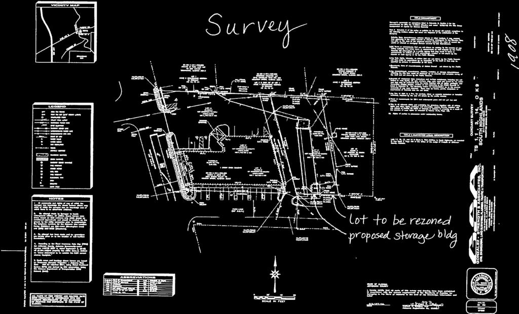
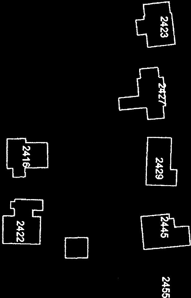
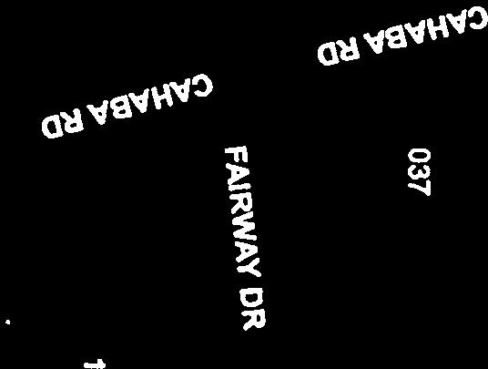
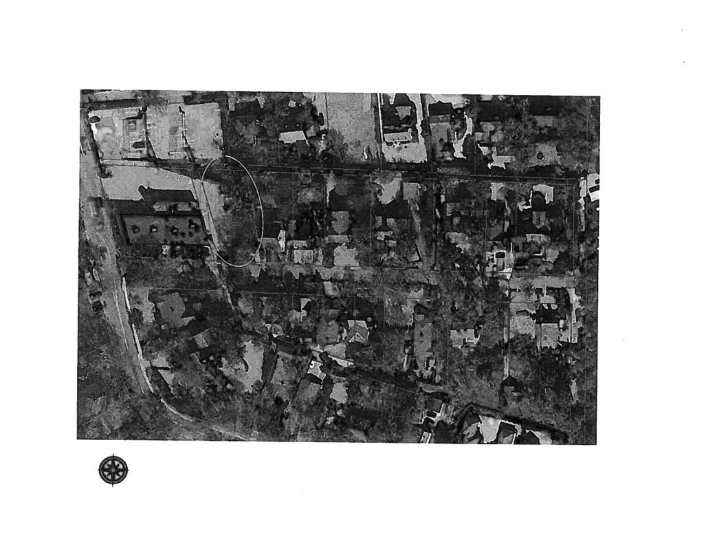
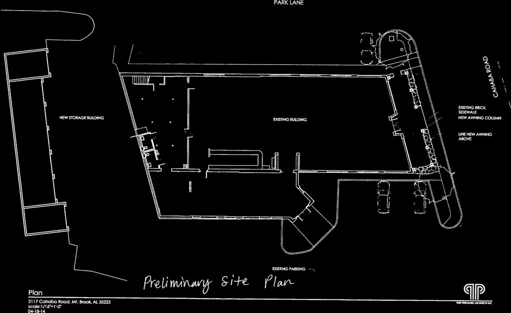
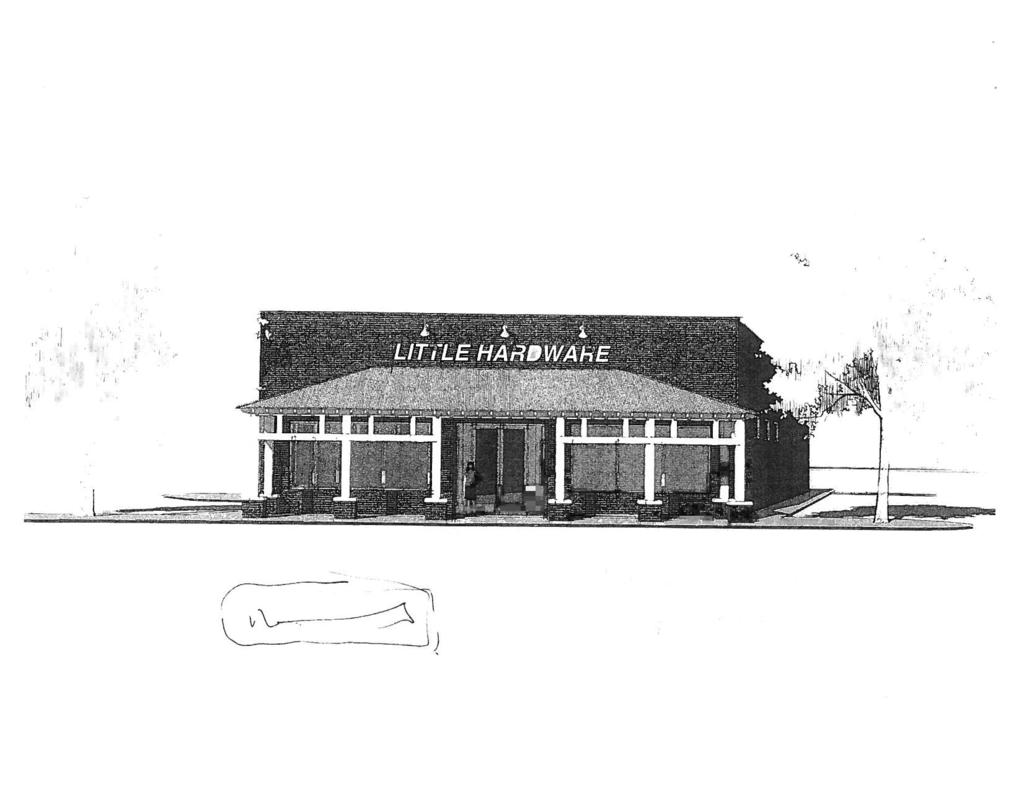
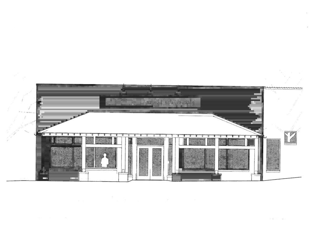
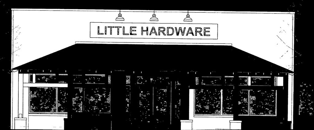
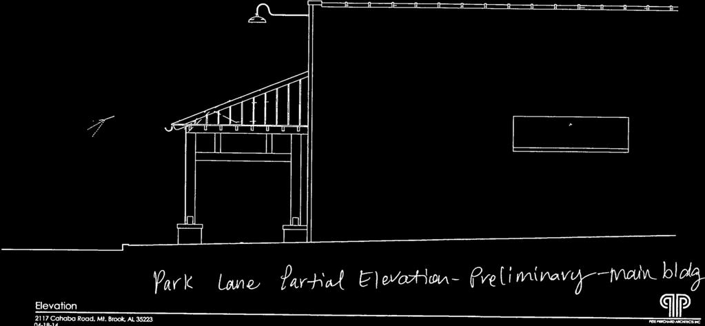
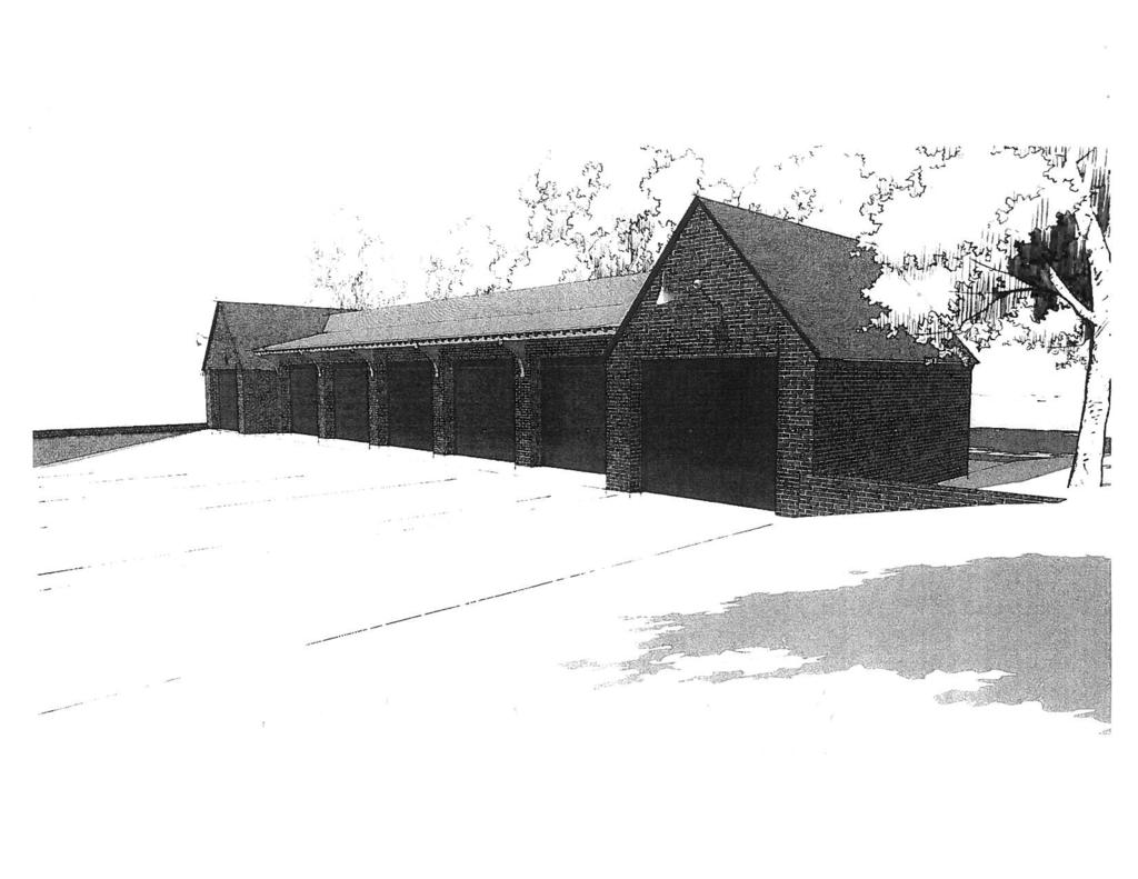
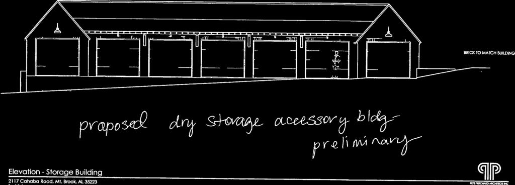
2 Council Memo - May 12,2014 Park LandLittle Hardware - Rezoning from Res-C to Local Business Petition Summary Request to rezone a portion of the Park Lane property in English Village from Residence- C to Local Business. Background The subject lot (highlighted in yellow on attached survey) is owned by the same entity that owns the Park Lane banquet facility property and has historically been used for parking for Arrnan's and Park Lane. As may be seen on the attached zoning map and survey, there is a "paper" alley that separates the lot which contains the Park Lane building and the subject lot. This paper alley was most likely paved by the property owner and has historically been used as a part of the Arman's/Park Lane parking lot and ingresslegress from the Park Lane right-of-way to the south. The survey also indicates a fence on the subject lot that essentially bisects the lot, running north-south just to the right of the proposed "red building outline" shown on the survey. The topography on the westerly side of the fence is relatively flat, and is utilized for Park Lane parking. The topography on the easterly side of the fence is sloping and is utilized as a vegetative buffer (per an agreement originating with the Arman's development, for the benefit of the residential property to the immediate east of the subject lot). Analysis The request for rezoning stems from a current lease proposal to relocate Little Hardware from Mountain Brook Village to the Park Lane building in English Village. The proposed hardware tenant will have a need for a detached dry-storage building, and that building is proposed on the subject Res-C lot. The proposed building is shown in red on the attached survey, site plan and elevation, but is indicated for illustrative purposes only (the actual size, location, setbacks and other development factors have yet to be formally proposed), and any approval of this rezoning request would not give implicit permission to construct the building indicated on the survey. The purpose for the rezoning is to allow commercial use of "Parcel #2" on attached Exhibit Map, which is not permitted under the current Res-C zoning. As proposed, the portion of the subject lot which is to the east of the existing fence ("Parcel #I" on attached Exhibit Map) would be deed-restricted to remain as a vegetative buffer. See attached "Commitment to Restrict Usage of Lot 1 1 ;" these deed restrictions have been drafted in cooperation with the property owner to the immediate east of the subject lot and are subject to revision and approval by the City Attorney. Planning Commission Recommendation on Rezoning On May 5,20 14, the Planning Commission recommended approval of the rezoning. Many residents of the neighborhood were in attendance and were in support of the rezoning and the project. No one spoke in opposition to the project, but concerns were expressed about limiting the commercial vehicular use of Park Lane and not allowing a
 2.")
3 third entrance to the proposed Little Hardware building from Park Lane. The Planning Commission's favorable recommendation to approve the rezoning included the following suggestions: Applicant: 1. Modify deed restriction language as cccovenants" that run with the land, rather than "deed restrictions." (revisions in progress) 2. Delete covenant reference to the unrestricted portion of Lot 11 remaining undeveloped unless developed in its entity as a single family dwelling site. (revisions in progress) 3. Depict, in an exhibit attached to proposed deed restrictions, the areas referred to in the covenants as "restricted" and "unrestricted." (attached) City StaWCouncil: 1. Have Police Department forward any recommendations to the Council regarding circulationfdelivery truck ingress egress to subject site. (Police Department will make recommendations at hearing) 2. City Attorney to review and approve covenant language. (in progress) Subject Property and Surrounding Land Uses The subject parcel is utilized partially for commercial parking and partially for a vegetative buffer. Properties to the north contain public parking lots and one single family dwelling. To the east and south are single family dwellings, and to the west is the Park Lane banquet facility. Affected Regulation Article V, Residence C District; Section , Permitted Uses Article VII, Local Business District Appends LOCATION: Cahaba Road ZONING DISTRICT: Residence-C OWNER: Mangina & Levio, LLC AGENT: Mike Mouron
4


5 fc I I... EXHIBIT MAP SE 1/4 OF THE SE 1/4 OF SECTION 6, TOWNSHIP 18 SOUTH, RANGE 2 WEST JEFFERSON COUNTY, ALABAMA DRAWING: #

6 Total-PropJune Clustered Residential a Community Shopping [ Residence A District Residence F District Recreation District


7

8 I COMMITMENT TO RESTRICT USAGE OF: LOT 11, BLOCK 9,lST ADDITION TO SOUT HIGHLANDS, JEFFERSON ALABAMA COUNTY, THIS COMMITMENT is made this day of, 2014, by MICHAEL A. MOURON, 402 Ofice Park Drive, Suite 150, Birmingham, Jefferson County, Alabama 35223, (hereinafter referred to as the "Grantor", which includes the plural of the word where the context requires, and shall, unless the context clearly indicates otherwise, include the Grantor's heirs, administrators, legal representatives, devisees, successors, and assigns) and hereby imposes the following restrictions on that portion of the lot specified herein and as follows (hereinafter referred to as the "Restricted Portion"): A parcel of land being part of Lot 11, Block 9, 1st Addition to South Highlands as recorded in Map Book 7, Pages 105 and 106 in the Office of the Judge of Probate of Jefferson County, Alabama and being situated in the Southeast one-quarter of the Southeast onequarter of Section 6, Township 18 South, Range 2 West, Jefferson County, Alabama being more particularly described as follows: Beginning at a set 518 inch capped rebar stamped GSA CA-560LS marking the Southeast comer of said Lot 11 said point also lying on the Northerly right of way of Park Lane (50' R.O.W.); thence run North 88 degrees 51 minutes 55 seconds West along said Northerly right of way and along the South lot line of said Lot 11 for a distance ofl6.95 feet; thence leaving said Northerly right of way and South lot line run North 01 degrees 11 minutes 47 seconds West for a distance of feet; thence run North 63 degrees 19 minutes 03 seconds West for a distance of 3.36 feet; thence run North 08 degrees 57 minutes 5 1 seconds West for a distance of14.17 feet; thence run North 31 degrees 22 minutes 47 seconds East for a distance of feet to a point on the East lot line of said Lot 11 ; thence run South 10 degrees 45 minutes 36 seconds East along said East lot line for a distance of feet to the POINT OF BEGINNING. Said parcel contains 2,739 square feet, or 0.06 acres more or less Formatted. Left: 1': IUght: 1.

9 Lot 11 less Restricted Portion is hereinafter referred to as the "Unrestricted Portion". The following restrictions shall apply: The Restricted Portion shall remain a natural buffer and open space area for the benefit of neighboring landowners, including, but not limited to, Maxwell H. and Teresa T. Pulliam, (the "Neighbors") their heirs, administrators, legal representatives, devisees, successors, and assigns, which Neighbors are the current owners of Lot 10, Block 9, 1st Addition to South Highlands as recorded in Map Book 7, Pages 105 and 106 in the Office of the Judge of Probate of Jefferson County, Alabama. Removal of vegetation from the Restricted Portion is prohibited, except for the removal of dead, diseased, or invasive species. The Grantor shall not remove any tree, shrub, lawn or ornamental planting without first consulting with and reaching an agreement with the Neighbors. The Neighbors are granted express permission to enter and remain upon the Restricted Portion for the purpose of maintaining beds and plantings and for removing dead, diseased, or invasive species. The Grantor shall not remove any existing wall or fence from the Restricted Portion without first consulting with and reaching an agreement with the Neighbors. The Grantor agrees to maintain and keep in good repair at its expense the existing wooden privacy fences which currently exist on the Restricted Portion and which mark or form the Western and Northern boundaries of the Restricted Portion. This commitment shall run with the land and shall be binding upon the Grantor, tenants and any subsequent owners and tenants, their successors, heirs or assigns. Any lease of the said specific parcel shall be subject to this restriction. This commitment is made with the intent and understanding between Grantor and the Neighbors that the immediate future use of the building currently existing on Lot 12 and Lot 13, Block 9, 1st Addition to South Highlands as recorded in Map Book 7, Pages 105 and 106 in the Ofice of the Judge of Probate of Jefferson County, Alabama, is anticipated to be a hardware store and the Unrestricted Portion of Lot 1 1 shall serve the parking and dry-storage needs of the operation of

10 a hardware store, as permitted by Alabama law and the City of Mountain Brook Code, its zoning and land use regulations. Should the building currently existing on said Lot 12 and Lot 13 cease to be used as a hardware store for whatever reason or on account of any cause, Grantor expressly agrees that the use of the Unrestricted Portion of said Lot 1 1 shall remain as parking and/or storage for the fbture owners or tenants of Lot 12 and Lot 13. The Restricted Portion of Lot 11 will remain undeveloped unless and until the entirety of Lot 1 1 is developed as a single family home. The above restrictions are intended to represent enforceable conditions under Alabama law and the City of Mountain Brook Code. These conditions are intended to be complied with in perpetuity. If any portion of this Deed Restriction document is deemed unenforceable, the unenforceable portion shall not affect the validity or enforceability the remaining portions of this document. IN ORDER FOR THIS COMMITMENT TO BE BINDING ON GRANTOR, GRANTOR MUST FIRST PURCHASE THE SUBJECT PARCEL. M WITNESS WHEREOF, I hereby set my hand this, GRANTOR: By: day of date STATE OF ALABAMA ) JEFFERSON COUNTY ) I, the undersigned, a Notary Public in and for said County, in said State, hereby certify that whose name is signed to the foregoing document, and who is known to me, acknowledged before me on this day that, being informed of the contents of the document, he executed the same voluntarily on the day the same bears date. Given under my hand and official seal this day of,2014.
11 Notary Public

12 Parcel 1 Legal Description A parcel of land being part of Lot 11, Block 9, 1' Addition to South Highlands as recorded in Map Book 7, Pages 105 and 106 in the Off~ce of the Judge of Probate of Jefferson County, Alabama and being situated in the Southeast one-quarter of the Southeast one-quarter of Section 6, Township 18 South, Range 2 West, Jefferson County, Alabama being more particularly described as follows: Beginning at a set 518 inch capped rebar stamped GSA CA-560LS marking the Southeast comer of said Lot 1 1 said point also lying on the Northerly right of way of Park Lane (50' R.O.W.); thence run North 88 degrees 5 1 minutes 55 seconds West along said Northerly right of way and along the South lot line of said Lot 1 1 for a distance of feet; thence leaving said Northerly right of way and South lot line run North 01 degrees 11 minutes 47 seconds West for a distance of feet; thence run North 63 degrees 19 minutes 03 seconds West for a distance of 3.36 feet; thence run North 08 degrees 57 minutes 5 1 seconds West for a distance of feet; thence run North 31 degrees 22 minutes 47 seconds East for a distance of feet to a point on the East lot line of said Lot 1 1 ; thence run South 10 degrees 45 minutes 36 seconds East along said East lot line for a distance of feet to the POINT OF BEGINNING. Said parcel contains 2,739 square feet, or 0.06 acres more or less.

13 Parcel#2 Legal Description A parcel of land being part of Lot 1 1, Block 9 ls' Addition to South Highlands as recorded in Map Book 7, Pages 105 and 106 in the Office of the Judge of Probate of Jefferson County, Alabama and being situated in the Southeast one-quarter of the Southeast one-quarter of Section 6, Township 18 South, Range 2 West, Jefferson County, Alabama being more particularly described as follows: Commencing at a set 5/8 inch capped rebar stamped GSA CA-560LS marking the Southeast comer of said Lot 1 1 said point also lying on the Northerly right of way of Park Lane (50' R.O.W.); thence run North 88 degrees 51 minutes 55 seconds West along said Northerly right of way and along the South lot line of said Lot 1 1 for a distance of feet to the POINT OF BEGINNING of the parcel herein described; thence run North 88 degrees 51 minutes 55 seconds West along said Northerly right of way for a distance of feet to a set nail marking the intersection of said Northerly right of way and the Easterly right of way of a 15 foot Alley said point also being the Southwest comer of said Lot 1 1 ; thence leaving said Northerly right of way run North 15 degrees 45 minutes 1 1 seconds West along said Easterly right of way and along the West lot line of said Lot 1 1 for a distance of feet to a found 518 inch rebar marking the Northwest corner of said Lot 11; thence leaving said Easterly right of way run South 88 degrees 40 minutes 58 seconds East along the North lot line of said Lot 1 1 for a distance of feet to a found 518 inch rebar marking the Northeast comer of said Lot 1 1; thence leaving said North line run South 10 degrees 45 minutes 36 seconds East along the East lot line of said Lot 1 1 for a distance of feet; thence leaving said East line run South 3 1 degrees 22 minutes 47 seconds West for a distance of feet; thence run South 08 degrees 57 minutes 5 1 seconds East for a distance of feet; thence run South 63 degrees 19 minutes 03 seconds East for a distance of 3.36 feet; thence run South 01 degrees 1 1 minutes 47 seconds East for a distance of feet to the POINT OF BEGINNING. Said parcel contains 6,956 square feet, or 0.16 acres more or less.


14


15
16


17

18
19
EASEMENT AGREEMENT. WHEREAS, Hall Brothers owns certain real property located in Weber County, Utah ( Hall Brothers Property );
;") When Recorded Return to: Parcel No. EASEMENT AGREEMENT THIS EASEMENT AGREEMENT ( Agreement ) is entered into this day of, 2016 by and between VALLEY DREAMS PROPERTIES, LLC, a Utah limited liability company
When Recorded Return to: Parcel No. EASEMENT AGREEMENT THIS EASEMENT AGREEMENT ( Agreement ) is entered into this day of, 2016 by and between VALLEY DREAMS PROPERTIES, LLC, a Utah limited liability company
NON-EXCLUSIVE ROADWAY AND UTILITY EASEMENT DEED AND AGREEMENT
 RETURN TO: STOGSDILL LAW OFFICE, P.C. 505 West Main, Suite 313 Lewistown, Montana 59457 (406) 538-2623 NON-EXCLUSIVE ROADWAY AND UTILITY EASEMENT DEED AND AGREEMENT THIS EASEMENT DEED AND AGREEMENT is
Sketch & Legal Description of Mitigation Bank and Ingress/Egress Access Easements
 Appendix H: Sketch & Legal Description of Mitigation Bank and Ingress/Egress Access Easements Tippen Bay Wetland Mitigation Bank DeSoto County, Florida Prepared by: September, 2017 Original file
COUNCIL ACTION FORM Meeting Date: September 13, 2012 Staff Contact: John Sullivan, Public Works Director
 COUNCIL ACTION FORM Meeting Date: September 13, 2012 Staff Contact: John Sullivan, Public Works Director Agenda Item: Consider vacation of a Landscape Easement granted to the City of Westwood for the construction
2. Descri~tion of Affected Pro~ertv. The property that is the subject of the rezoning approved by this ordinance is described as follows:
 ORDINANCE NO. 1932 AN ORDINANCE TO AMEND THE MASTER DEVELOPMENT PLAN FOR THE PARK AT OVERTON, IN THE CITY OF MOUNTAIN BROOK, ALABAMA, TO ALLOW A PATIO COVER ON LOT 6 (3766 VILLAGE LANE) TO BE 4.98 FEET
SAMPLE DECLARATION OF VACATION OF EASEMENT/RIGHT OF WAY. of record in the Office of the Judge of Probate of Morgan County, Alabama in Plat
 SAMPLE DECLARATION OF VACATION OF EASEMENT/RIGHT OF WAY ) KNOW ALL MEN BY THESE PRESENTS, THAT: OWNER S NAME, owner of all of the property adjacent to that certain drainage, utilities, and telecommunications
LANDSCAPE AND MAINTENANCE EASEMENT. THIS LANDSCAPE AND MAINTENANCE EASEMENT, (hereinafter Easement )
") Prepared by and return to: Parcel ID # LANDSCAPE AND MAINTENANCE EASEMENT THIS LANDSCAPE AND MAINTENANCE EASEMENT, (hereinafter Easement ) is made and entered into this day of, 2009, by and between THIRD
Prepared by and return to: Parcel ID # LANDSCAPE AND MAINTENANCE EASEMENT THIS LANDSCAPE AND MAINTENANCE EASEMENT, (hereinafter Easement ) is made and entered into this day of, 2009, by and between THIRD
COUNCIL AGENDA MEMO ITEM NO. III - #1
 COUNCIL AGENDA MEMO ITEM NO. III - #1 FROM: Anton Jelinek, Director of Utilities MEETING: October 24, 2017 SUBJECT: PRESENTER: Permanent Utility and Right-of-Way Easement Anton Jelinek Discussion: At the
DRAINAGE AND UTILITY EASEMENT. That Bruce Conrad, a single adult, hereinafter referred to as Grantor for good and
 DRAINAGE AND UTILITY EASEMENT KNOW ALL PERSONS BY THESE PRESENTS: That Bruce Conrad, a single adult, hereinafter referred to as Grantor for good and valuable consideration, the receipt and sufficiency
EASEMENT AGREEMENT. WHEREAS, Ferguson is the 100% owner of the property described on Exhibit B attached hereto (the Williams Property );
;") EASEMENT AGREEMENT THIS EASEMENT AGREEMENT ( Agreement ) is entered into as of this day of, 2016, by and between CRAIG FERGUSON ( Ferguson ), and MAMIE DAVIS and JERRY MOORE ( Davis & Moore ), whose legal
EASEMENT AGREEMENT THIS EASEMENT AGREEMENT ( Agreement ) is entered into as of this day of, 2016, by and between CRAIG FERGUSON ( Ferguson ), and MAMIE DAVIS and JERRY MOORE ( Davis & Moore ), whose legal
CONSENT ACTION BY THE BOARD OF DIRECTORS OF VENETO IN MIRAMAR CONDOMINIUM ASSOCIATION, INC.
 CONSENT ACTION BY THE BOARD OF DIRECTORS OF VENETO IN MIRAMAR CONDOMINIUM ASSOCIATION, INC. The undersigned, being all of the members of the Board of Directors of Veneto in Miramar Condominium Association,
RECITALS. 3. On January 15, 2019 the Village Plan Commission considered recommended approval of the CSM and the Agreement.
 VILLAGE BOARD VILLAGE OF SHOREWOOD HILLS DANE COUNTY, WISCONSIN RESOLUTION NO. R-2019-1 A RESOLUTION APPROVING OF A CERTIFIED SURVEY MAP AND THE RELEASE OF CROSS EASEMENTS (DPPG, LLC) RECITALS 1. The Village
REVIEWED BY: Administrator Counsel Program Mgr.: Tiffany Schaufler Board Committee Engineer Other
 Minnehaha Creek Watershed District REQUEST FOR BOARD ACTION MEETING DATE: May 11, 2017 TITLE: Authorization to Grant a Temporary Easement to the City of Minnetrista RESOLUTION NUMBER: 17-034 PREPARED BY:
ORDINANCE WHEREAS, the Planning and Zoning Board of the City of Belleview has been designated as the Local Planning Agency; and
 Page 1 of 9 ORDINANCE 2019-03 AN ORDINANCE OF THE CITY OF BELLEVIEW, FLORIDA RELATING TO AN AMENDMENT OF 8.87 +/- ACRES OF LAND TO THE CITY OF BELLEVIEW COMPREHENSIVE PLAN; AMENDING THE FUTURE LAND USE
MEETING TYPE: Board of Commissioners - Regular. MEETING DATE: 23 May STAFF RESPONSIBLE: Matt Hubert. DEPARTMENT: Development Services Department
 MEETING TYPE: Board of Commissioners - Regular MEETING DATE: 23 May 2017 STAFF RESPONSIBLE: Matt Hubert DEPARTMENT: Development Services Department DESCRIPTION Approval of Easement Agreement To approve
AMENDED DEED OF CONSERVATION EASEMENT
 Prepared by: Wayne E. Flowers Lewis, Longman & Walker, P.A. 245 Riverside Ave. Suite 150 Jacksonville, FL 32202 Return recorded original to: Mitigation Marketing 1091 W. Morse Blvd. Suite 101 Winter Park,
David L. Brown, Construction Services Manager
 Memorandum Date: 2/02/2013 Order Date: 2/27/2013 TO: DEPARTMENT: PRESENTED BY: AGENDA ITEM TITLE: Board of County s Public Works David L. Brown, Construction Services Manager In the Matter of Authorizing
AMENDED DECLARATION OF COVENANTS FOR COUNTRY CREEK SUBDIVISION
 AMENDED DECLARATION OF COVENANTS FOR COUNTRY CREEK SUBDIVISION THIS AMENDED DECLARATION OF COVENANTS, made this 17th day of February, 2004, by Frontier Land Company, an Indiana corporation (hereinafter
DEED OF EASEMENT & MAINTENANCE AGREEMENT FOR STORMWATER MANAGEMENT FACILITIES THIS DEED OF EASEMENT AND MAINTENANCE AGREEMENT FOR
 (The City of Chesapeake is exempt from recordation taxes pursuant to Section 58.1-811.A.3. and Grantors are exempt pursuant to Section 58.1-811.C.5. of the 1950 Code of Virginia as amended.) DEED OF EASEMENT
ORDINANCE NO AN ORDINANCE To Be Entitled:
 3808 AN ORDINANCE To Be Entitled: AN ORDINANCE OF THE CITY COUNCIL OF THE CITY OF FORT MYERS, FLORIDA, REZONING FROM COMMERCIAL GENERAL TO PLANNED UNIT DEVELOPMENT AND APPROVING THE DEVELOPMENT PLAN FOR
BILL NO (Emergency Measure) ORDINANCE NO. 5072
 ORDINANCE NO. 5072") BILL NO. 5210 (Emergency Measure) ORDINANCE NO. 5072 AN ORDINANCE AUTHORIZING THE MAYOR TO EXECUTE WITH MICHELSON-HADLEY HEIGHTS DEVELOPMENT, LLC, A CONTRACT AND QUIT CLAIM DEED CONVEYING CERTAIN PROPERTIES
BILL NO. 5210 (Emergency Measure) ORDINANCE NO. 5072 AN ORDINANCE AUTHORIZING THE MAYOR TO EXECUTE WITH MICHELSON-HADLEY HEIGHTS DEVELOPMENT, LLC, A CONTRACT AND QUIT CLAIM DEED CONVEYING CERTAIN PROPERTIES
"ARTICLE - VINE STREET TRANSITIONAL (VST) DISTRICT
 DISTRICT") ORDINANCE NO. 1899 AN ORDINANCE AMENDING SECTIONS 129-551,129-552,129-553 AND 129-416 OF THE CITY CODE ALL INVOLVING THE ADDITION OF THE VINE STREET TRANSITIONAL DISTRICT ZONING CLASSIFICATION TO THE ZONING
ORDINANCE NO. 1899 AN ORDINANCE AMENDING SECTIONS 129-551,129-552,129-553 AND 129-416 OF THE CITY CODE ALL INVOLVING THE ADDITION OF THE VINE STREET TRANSITIONAL DISTRICT ZONING CLASSIFICATION TO THE ZONING
MEMORANDUM. Mayor and City Council. Warren Hutmacher, City Manager. Date: February 11, 2013
 MEMORANDUM To: From: Mayor and City Council Warren Hutmacher, City Manager Date: February 11, 2013 Subject: Approval of an Intergovernmental agreement by and between the City of Dunwoody and DeKalb County
CITY OF ROHNERT PARK CITY COUNCIL AGENDA REPORT
 Meeting Date: February 12, 2013 Mission Statement We Care for Our Residents by Working Together to Build a Better Community for Today and Tomorrow. CITY OF ROHNERT PARK CITY COUNCIL AGENDA REPORT ITEM
PIPELINE RIGHT-OF-WAY EASEMENT
 PIPELINE RIGHT-OF-WAY EASEMENT THIS RIGHT-OF-WAY EASEMENT made this day of March, 2014, by the City of Rochester Hills, a municipal corporation in the State of Michigan,, having an address at 1000 Rochester
AMENDED AGENDA SCARBOROUGH TOWN COUNCIL WEDNESDAY FEBRUARY 21, 2018 REGULAR MEETING 6:00 P.M. NO NEW BUSINESS SHALL BE TAKEN UP AFTER 10:00 P.M.
 Item 1. Call to Order. Item 2. Pledge of Allegiance. Item 3. Roll Call. AMENDED AGENDA SCARBOROUGH TOWN COUNCIL WEDNESDAY FEBRUARY 21, 2018 REGULAR MEETING 6:00 P.M. NO NEW BUSINESS SHALL BE TAKEN UP AFTER
PUD Ordinance - Cascade Lakes Plat #10 of 1995
 PUD Ordinance - Cascade Lakes Plat #10 of 1995 CASCADE CHARTER TOWNSHIP Ordinance #10 of 1995 AN ORDINANCE TO AMEND THE CASCADE CHARTER TOWNSHIP ZONING ORDINANCE AND ZONING MAP TO ESTABLISH THE CASCADE
TAFFREPORT. Steven A. Preston, FAICP, City Manager. Jennifer Davis, Community Development Director W trm-?f>
 Community Development Department TAFFREPORT Date: To: From: January 07, 2014 Steven A. Preston, FAICP, City Manager Jennifer Davis, Community Development Director W trm-?f> By: Daren Grilley, PE, City
FIFTH AMENDMENT OF DECLARATION OF DEED RESTRICTIONS AND DEDICATIONS FOR PINEHURST ESTATES (A Clatsop County, Oregon Subdivision)
") After Recording Return To: W. Louis Larson 990 Astor Street Astoria, OR 97103 FIFTH AMENDMENT OF DECLARATION OF DEED RESTRICTIONS AND DEDICATIONS FOR PINEHURST ESTATES (A Clatsop County, Oregon Subdivision)
After Recording Return To: W. Louis Larson 990 Astor Street Astoria, OR 97103 FIFTH AMENDMENT OF DECLARATION OF DEED RESTRICTIONS AND DEDICATIONS FOR PINEHURST ESTATES (A Clatsop County, Oregon Subdivision)
UNITED STATES DEPARTMENT OF THE INTERIOR BUREAU OF INDIAN AFFAIRS CHICKASAW AGENCY
 Exhibit 15: State of Oklahoma, Choctaw Nation of Oklahoma, Chickasaw Nation, City of Oklahoma City Water Settlement File No. Allottee: Parcel No. AFTER RECORDING RETURN TO: City of Oklahoma City Office
in Book 10019, at Page 9432, 352 feet, more, or less, to the North right of way of 3350 South Street; thence West along said right of way 93 feet,
 Public notice is hereby given that the Millcreek Community Reinvestment Agency (the Agency ) will hold a public hearing on Tuesday, November 13, 2018, commencing at 7:30 p.m. or as soon thereafter as the
DEED AND DEDICATION FOR PUBLIC RIGHT OF WAY
 TO : BOARD OF DIRECTORS FROM : GARY PLATT, EXEC. DIRECTOR BUSINESS AND OPERATIONS SUBJECT : CITY OF STANWOOD CONSTRUCTION EASEMENT AND RIGHT-OF-WAY DEDICATION DATE : MARCH 17, 2009 TYPE : ACTION NEEDED
CITY OF PUNTA GORDA ORDINANCE NO.
 CITY OF PUNTA GORDA ORDINANCE NO. AN ORDINANCE OF THE CITY OF PUNTA GORDA, FLORIDA, REZONING PROPERTIES GENERALLY DESCRIBED AS 901, 1001, AND 1101 AQUI ESTA DRIVE, PUNTA GORDA, FLORIDA, AND MORE PARTICULARLY
DECLARATION OF RESTRICTIVE COVENANT
 This instrument prepared by: D. Scott Knight Hillsborough County Aviation Authority PO Box 22287 Tampa, FL 33622 DECLARATION OF RESTRICTIVE COVENANT THIS DECLARATION OF RESTRICTIVE COVENANT (hereinafter
Road Maintenance Agreement (RMA)
") Road Maintenance Agreement (RMA) This declaration is made by SUGARLOAF MOUNTAIN, LLC, a Montana Limited Liability Company, herein referred to as Declarant. RECITALS (a) Declarants are the owners of the
Road Maintenance Agreement (RMA) This declaration is made by SUGARLOAF MOUNTAIN, LLC, a Montana Limited Liability Company, herein referred to as Declarant. RECITALS (a) Declarants are the owners of the
ORDINANCE NO (PROPOSED)
") ORDINANCE NO. 1604 (PROPOSED) AN ORDINANCE OF THE CITY OF COCOA BEACH, BREVARD COUNTY, FLORIDA; AMENDING THE OFFICIAL ZONING MAP OF THE CITY OF COCOA BEACH, BY CHANGING THE ZONING DESIGNATION ON TWO PARCELS
ORDINANCE NO. 1604 (PROPOSED) AN ORDINANCE OF THE CITY OF COCOA BEACH, BREVARD COUNTY, FLORIDA; AMENDING THE OFFICIAL ZONING MAP OF THE CITY OF COCOA BEACH, BY CHANGING THE ZONING DESIGNATION ON TWO PARCELS
TOWNSHIP OF LOWER MERION Building & Planning Department
 Exhibit C TOWNSHIP OF LOWER MERION Building & Planning Department MEMORANDUM TO: Douglas S. Cleland, Township Manager FROM: Robert E. Duncan, Director of Building & Planning SUBJECT: 11 East Athens Avenue
GREENWAY EASEMENT AGREEMENT
 GREENWAY EASEMENT AGREEMENT This greenway access easement is entered into by and between the Laramie County School District Number One ( Grantor ), a corporate body organized under the laws of the State
VILLAGE OF LAKE ZURICH ORDINANCE NO
 VILLAGE OF LAKE ZURICH ORDINANCE NO. 2018-05-257 AN ORDINANCE GRANTING APPROVAL FOR A PLANNED UNIT DEVELOPMENT, DEVELOPMENT CONCEPT PLAN, SPECIAL USE PERMITS, AND MODIFICATIONS TO THE ZONING AND LAND DEVELOPMENT
ARTICLES OF INCORPORATION of HARTRIDGE HARBOR OWNERS' ASSOCIATION, INC.
 ARTICLES OF INCORPORATION of HARTRIDGE HARBOR OWNERS' ASSOCIATION, INC. In compliance with the requirements of Chapter 617 of the Florida Statutes, the undersigned, all of whom are residents of Polk County,
STORMWATER MANAGEMENT AGREEMENT AND DECLARATION OF EASEMENT
 APPENDIX F STORMWATER MANAGEMENT AGREEMENT AND DECLARATION OF EASEMENT THIS AGREEMENT AND DECLARATION OF EASEMENT made this day of 20, by and between BRECKNOCK TOWNSHIP, Lancaster County, Pennsylvania,
ORDINANCE N0.18-ll6. WHEREAS, City has prepared a Service Plan for said tract which is attached as Exhibit "A" to this ordinance; &
 c: 0 ORDINANCE N0.18-ll6 AN ORDINANCE ANNEXING THE HEREINAFTER DESCRIBED TERRITORY TO THE CITY OF FORT STOCKTON, PECOS COUNTY, TEXAS, AND EXTENDING THE BOUNDARY LIMITS OF SAID CITY SO AS TO INCLUDE SAID
SIDEWALK ACCESS EASEMENT AGREEMENT
 SIDEWALK ACCESS EASEMENT AGREEMENT THIS SIDEWALK ACCESS EASEMENT AGREEMENT ( Agreement ) is made by and among WATERWALK PLACE OWNERS ASSOCIATION, a Kansas non-profit corporation ( WWP ), FOUR-G, LLC, a
CITY OF SARATOGA SPRINGS ZONING ORDINANCE
 Appendix C: 8. The Village At Saratoga Planned Unit Development (formerly 241.8) Chapter 241.8 AN ORDINANCE PROVIDING FOR THE ESTABLISHMENT OF A PLANNED UNIT DEVELOPMENT DISTRICT TO BE KNOWN AS "THE VILLAGE
Utility Easement from Suncoast Community Health Centers Inc Release of Easement
 0 YLANi AGENDA REPORT 5T FLORID DATE 10 24 11 TO FROM SUBJECT City Commission Gregory Horwedel City Manager Utility Easement from Suncoast Community Health Centers Inc Release of Easement RECOMMENDATION
PERMANENT DRAINAGE EASEMENT
 City Project No. Project Name: ; Tr. # Parcel No. (LLC, Corporation, Partnership) PERMANENT DRAINAGE EASEMENT THIS AGREEMENT, made and entered into this day of, 201, by and between, a, hereinafter called
PLANNING DIRECTOR. Approved by the Planning Director on this day of, A.D. 20. day of, A.D. 20. Approved by the Fire Chief on this
 Located in a portion of the West Half of Section 19, Township 5 South, Range 1 East, Salt Lake Base and Meridian. SURVEYOR'S CERTIFICATE I, the undersigned surveyor, do hereby certify that I am a registered
42-Acre Parcel Rezoning and Master Plan Amendment. Danny Cagle and Patrick Stanley 6301 Duckweed Rd. Lake Worth, FL 33449
 STAFF REPORT CITY OF PARKLAND DEVELOPMENT SERVICES DEPARTMENT Date Prepared: May 2, 2014 I. Petition Description Petition No.: Project Name: Owners: RZ14-001; MPA14-002 42-Acre Parcel Rezoning and Master
Exhibit A: REAL ESTATE TRANSFER AGREEMENT
 Exhibit A: REAL ESTATE TRANSFER AGREEMENT This agreement is made between the City of Urbana, Illinois, a municipal corporation of the State of Illinois (the Seller ), and Homestead Corporation of Champaign-Urbana,
DECLARATION OF DEED RESTRICTIONS
 Drawn by and Mail to: { Attorney or law firm) DECLARATION OF DEED RESTRICTIONS THIS DECLARATION OF DEED RESTRICTIONS (the Declaration ), made and entered into this the day of, 2014 by and between NAME
F e TA OUNTY RECORDER
 DEVELOPMENT AGREEMENT BETWEEN ROBERT C. PETERSON, AND CITY OF MOSCOW, IDAHO 542501 AT THE HE Q No. ""' ==
19.12 CLUSTER RESIDENTIAL DISTRICT
 Chapter 19.12 CLUSTER RESIDENTIAL DISTRICT (Adopted 12/22/2003; Ordinance #0061970). Amended 7/3/17, Ordinance #079100. Section 19.12.010 - Declaration of Intent. The Cluster Residential District provides
ORDINANCE NO An ordinance changing the zoning classification on the following property:
 8-27-14 ORDINANCE NO. 2 9 4 3 1 An ordinance changing the zoning classification on the following property: BEING a tract of land in City Block 1/7675; fronting approximately 125 feet on the west line of
Easement. After recording return to: City Clerk City of Puyallup 333 South Meridian Puyallup, WA 98371
 After recording return to: City Clerk City of Puyallup 333 South Meridian Puyallup, WA 98371 Document Title: Easement Grantor: Grantee: City of Puyallup Abbreviated Legal Description: A portion of Legal
PROCEDURE: CHANGE OF ACCESS ON RECORDED PLAT
 PROCEDURE: CHANGE OF ACCESS ON RECORDED PLAT The following procedure has been approved by the City/Traffic Engineering Department, County Engineering Department and the Tulsa Metropolitan Area Planning
RATE AND METHOD OF APPORTIONMENT FOR COMMUNITY FACILITIES DISTRICT NO. 4 - MAINTENANCE OF THE CITY OF MORENO VALLEY
 CFD No. 4 Maintenance Page 1 RATE AND METHOD OF APPORTIONMENT FOR COMMUNITY FACILITIES DISTRICT NO. 4 - MAINTENANCE OF THE CITY OF MORENO VALLEY A Special Tax as hereinafter defined shall be levied on
ORDINANCE NO. NOW, THEREFORE, BE IT ORDAINED BY THE COUNTY BOARD OF OGLE COUNTY, ILLINOIS, as follows:
 STATE OF ILLINOIS ) ) SS COUNTY OF OGLE ) ORDINANCE NO. AN ORDINANCE APPROVING A ZONING MAP AMENDMENT ON PROPERTY LOCATED AT THE SOUTHEAST CORNER OF THE INTERSECTION OF N. JUNCTION ROAD AND DIVISION STREET,
AMBER CREEK METROPOLITAN DISTRICT. Resolution to Adopt Fees Regarding Covenant Enforcement, Design Review and Maintenance Services
 AMBER CREEK METROPOLITAN DISTRICT Resolution to Adopt Fees Regarding Covenant Enforcement, Design Review and Maintenance Services WHEREAS, Amber Creek Metropolitan District ( District ) is a quasi-municipal
AGREEMENT RECITALS: Draft 3/26/2015
 AGREEMENT This Agreement is entered into this day of April, 2015, by and between the SCHOOL BOARD OF BREVARD COUNTY, FLORIDA (the "School Board") and THE CITY OF MELBOURNE, a Florida municipal corporation
PERMANENT EASEMENT AGREEMENT
 PERMANENT EASEMENT AGREEMENT THIS PERMANENT EASEMENT AGREEMENT ( Agreement ) is made and entered into this day of, 2016 ( Effective Date ), by and between Staker & Parson Companies, a Utah corporation
CHARTER TOWNSHIP OF CALEDONIA COUNTY OF KENT, MICHIGAN. at the Township and Village Hall, 8196 Broadmoor Avenue, Caledonia, Michigan on the
 First Reading CHARTER TOWNSHIP OF CALEDONIA COUNTY OF KENT, MICHIGAN At a regular meeting of the Township Board of the Charter Township of Caledonia, held at the Township and Village Hall, 8196 Broadmoor
CONSERVATION EASEMENT INCLUDING MITIGATION
 After recording return to: GRANTOR: GRANTEE: GRANTEE (Trustee): LEGAL DESCRIPTION: TAX PARCEL I.D. #: REFERENCE # s: WHATCOM COUNTY N/A CONSERVATION EASEMENT INCLUDING MITIGATION This grant of a conservation
MECKLENBURG COUNTY Land Use & Environmental Services Agency Groundwater & Wastewater Services
 MECKLENBURG COUNTY Land Use & Environmental Services Agency Groundwater & Wastewater Services Instructions for Permitting On-Site Sewage Treatment & Disposal Systems Requiring a Septic System Easement,
ORDINANCE NO. 14 ST. JOSEPH COUNTY ADDRESS ORDINANCE DATE 1997 AMENDED NOVEMBER 15, 2005
 ORDINANCE NO. 14 ST. JOSEPH COUNTY ADDRESS ORDINANCE DATE 1997 AMENDED NOVEMBER 15, 2005 WHEREAS, the people of St. Joseph County have voted to establish an enhanced 9-1-1 Central Dispatch System; and
PROPERTY EXCHANGE & CONVEYANCE AGREEMENT RECITALS
 PROPERTY EXCHANGE & CONVEYANCE AGREEMENT This Property Exchange and Conveyance Agreement ( Agreement ) is entered into as of the date of execution by and between Laramie Church of Christ, Inc., a Wyoming
ORDINANCE NO An ordinance changing the zoning classification on the following property:
 9-17-14 ORDINANCE NO. 2 9 4 8 3 An ordinance changing the zoning classification on the following property: BEING a tract of land bounded by Alaska Avenue, Montana Avenue, Marsalis Avenue, and Illinois
City of Stevenson Planning Department
 City of Stevenson Planning Department (509)427-5970 7121 E Loop Road, PO Box 371 Stevenson, Washington 98648 TO: City Council FROM: Ben Shumaker DATE: January 16 th, 2014 SUBJECT: Bridging Byways Trail
(Space above this line reserved for Recorder of Deeds)
") (Space above this line reserved for Recorder of Deeds) STORMWATER MANAGEMENT and BEST MANAGEMENT PRACTICES FACILITIES MAINTENANCE AGREEMENT COVER PAGE Date: Grantor: Grantee: Property Owner Owner's Address
(Space above this line reserved for Recorder of Deeds) STORMWATER MANAGEMENT and BEST MANAGEMENT PRACTICES FACILITIES MAINTENANCE AGREEMENT COVER PAGE Date: Grantor: Grantee: Property Owner Owner's Address
City of Melissa, Texas Plat Dedication Language
 City of Melissa, Texas Plat Dedication Language [INCLUDE THE FOLLOWING DEDICATION LANGUAGE FOR INDIVIDUALS (MODIFY APPROPRIATELY TO REFLECT EXACTLY AS SHOWN ON PROPERTY DEED)]: NOW THEREFORE, KNOW ALL
RESOLUTION NO. RESOLUTION APPROVING ZONING PETITION 84-71, Special Exception. WHEREAS, the Board of County Commissioners, as the governing
 /. ;C- C, i RESOLUTION NO. R-@+-l2?8 RESOLUTION APPROVING ZONING PETITION 84-71, Special Exception WHEREAS, the Board of County Commissioners, as the governing body, pursuant to the authority vested in
TOWNSHIP OF ALGOMA. County, Michigan, held in the Algoma Township Hall, Algoma Avenue, N.E., within
 TOWNSHIP OF ALGOMA COUNTY OF KENT, MICHIGAN At a special meeting of the Township Board of the Township of Algoma, Kent County, Michigan, held in the Algoma Township Hall, 10531 Algoma Avenue, N.E., within
Resolution No
 EXHIBIT A Page 1 of 2 Resolution No. 17-34 RESOLUTION OF THE BOARD OF TRUSTEES OF THE SOUTH ORANGE COUNTY COMMUNITY COLLEGE DISTRICT AUTHORIZING THE DEDICATION OF AN EASMENT TO COX COMMUNICATIONS CALIFORNIA,
MAINTENANCE AND INDEMNITY AGREEMENT PURSUANT TO SEAGATE VILLAGE COMMUNITY ASSOCIAITON S DECLARATION OF COVENANTS, CONDITIONS AND RESTRICTIONS
 RECORDING REQUESTED BY AND WHEN RECORDED RETURN TO: Jeffrey A. French, Esq. (SBN 174968) GREEN BRYANT & FRENCH, LLP 402 W. Broadway, Suite 1950 San Diego, CA 92101 Telephone: (619) 239-7900 Fax No.: (619)
RIGHT OF WAY AND COMMON DRIVEWAY AGREEMENT SUN8 PDC, LLC, c/o DISTRIBUTED SUN, LLC SUBDIVISION DRYDEN, NEW YORK
 RIGHT OF WAY AND COMMON DRIVEWAY AGREEMENT SUN8 PDC, LLC, c/o DISTRIBUTED SUN, LLC SUBDIVISION DRYDEN, NEW YORK THIS RIGHT OF WAY AGREEMENT ( Agreement ) is made this day of, 2017 by SCOTT PINNEY, an individual
CHAPTER XIX ANNEXATION ARTICLE 1. ANNEXATION
 CHAPTER XIX ANNEXATION ARTICLE 1. ANNEXATION 19.0101 JABORSKY ADDITION: WHEREAS, The City of Belfield pursuant to Section 40-51.2-07 of the North Dakota Century Code has amended having passed a Resolution
GRANT OF TRAIL ACCESS EASEMENT, COVENANTS AND RESTRICTIONS
 This is a sample easement provided for discussion and illustrative purposes only. Easements for each property will be customized based upon the needs of each landowner and the Path. GRANT OF TRAIL ACCESS
E. 140TH AVE. VICINITY MAP SCALE: 1"=600' LAND USE TABLE NET AREA 599,946 SQFT AC. GROSS AREA 741,420 SQFT AC.
 SHEET OF PURPOSE STATEMENT: THIS PLAT IS INTENDED TO SUBDIVIDE. ACRES INTO SINGLE FAMILY ATTACHED LOTS, TRACTS, DEDICATE AND GRANT EASEMENTS. LEGAL DESCRIPTION: THE UNDERSIGNED BEING THE OWNER(S) OF A
SOUTH DAKOTA BOARD OF REGENTS. Committee on Budget and Finance ******************************************************************************
 SOUTH DAKOTA BOARD OF REGENTS Committee on Budget and Finance AGENDA ITEM: III O DATE: December 12-13, 2012 ****************************************************************************** SUBJECT: Resolution
DEVELOPMENT AGREEMENT FOR 841 NORTH MOUNTAIN VIEW ROAD BETWEEN CITY OF MOSCOW, IDAHO AND BRIAN AND VICTORIA LEFFINGWELL
 DEVELOPMENT AGREEMENT FOR 841 NORTH MOUNTAIN VIEW ROAD BETWEEN CITY OF MOSCOW, IDAHO AND BRIAN AND VICTORIA LEFFINGWELL No. 545873 AT THt: Rt:GUFST OF- ; - Ctp{!J!Nu tj=-- 1 i3 ;f - :.-)% LATA'r-'l.Jt..;NlY
This document was prepared by: Albemarle County Attorney County of Albemarle 401 McIntire Road Charlottesville, Virginia 22902
 This document was prepared by: Albemarle County Attorney County of Albemarle 401 McIntire Road Charlottesville, Virginia 22902 Tax Map and Parcel Number This deed is exempt from taxation under Virginia
Summary Report $396,383. Sales Information. Previous Sale
 Property Search Application - Miami-Dade County Page 1 of 2 Summary Report EXHIBIT A Generated On : 5/22/2017 Property Information Folio: 01-3135-016-0040 Property Address: 1515 NW S RIVER DR Miami, FL
STORMWATER BEST MANAGEMENT PRACTICES OPERATIONS AND MAINTENANCE AGREEMENT
 STORMWATER BEST MANAGEMENT PRACTICES OPERATIONS AND MAINTENANCE AGREEMENT THIS AGREEMENT, made and entered into this day of, 20, by and between, (hereinafter the Landowner ), and the TOWNSHIP OF HEMPFIELD,
Recitals. WHEREAS, Grantor owns real property ("Property"), under which Improvements (as defined in Section 1 below) will pass; and
, under which Improvements (as defined in Section 1 below) will pass; and") EASEMENT AGREEMENT This Easement Agreement ("Agreement") effective this 24 th day of April, 2017, by and between YMCA Community Campus, LLC, whose address is 3200 Spaulding Avenue, Pueblo, CO 81008 ( Grantor
EASEMENT AGREEMENT This Easement Agreement ("Agreement") effective this 24 th day of April, 2017, by and between YMCA Community Campus, LLC, whose address is 3200 Spaulding Avenue, Pueblo, CO 81008 ( Grantor
ORDINANCE NO
 DRAFT NO. 16-53 ORDINANCE NO. 2016-49 AN ORDINANCE ACCEPTING FOR DEDICATION PURPOSES FROM GARY PHILLIP BERARDINELLI A STORM SEWER EASEMENT, AND DECLARING AN EMERGENCY. WHEREAS, Gary Phillip Berardinelli
CONSERVATION EASEMENT AND RESTRICTION
 CONSERVATION EASEMENT AND RESTRICTION The purpose of a Conservation Easement is to protect in perpetuity significant natural features and to minimize the environmental impact of activities associated with
WHEREAS, the Petition is in all ways in complete compliance with the provisions of the Act; and,
 ORDINANCE NO. 15,700 AN ORDINANCE continuing the Downtown Des Moines Self-Supported Municipal Improvement District pursuant to the provisions of Chapter 386, Code of Iowa; and providing for the continuation
MINUTES OF A REGULAR PLANNING COMMISSION MEETING HELD, TUESDAY, OCTOBER 11, :30 P.M. ROCKVILLE CITY HALL
 28 MINUTES OF A REGULAR PLANNING COMMISSION MEETING HELD, TUESDAY, OCTOBER 11, 2011 6:30 P.M. ROCKVILLE CITY HALL The meeting was called to order by Chair Toni Honer. Roll call was taken and the following
APPLICATION TO REGISTER NOTICE OF AN AGREEMENT THE LAND TITLES ACT SECTION 74
 26 th May 1981 Campeau - City of Kanata 40% Open Space Agreement APPLICATION TO REGISTER NOTICE OF AN AGREEMENT THE LAND TITLES ACT SECTION 74 TO: THE LAND REGISTRAR FOR THE LAND TITLES DIVISION OF OTTAWA-CARLETON
ARLINGTON COUNTY, VIRGINIA. County Board Agenda Item Meeting of January 27, 2018
 ARLINGTON COUNTY, VIRGINIA County Board Agenda Item Meeting of January 27, 2018 DATE: January 22, 2018 SUBJECT: Deed of Easement for Public Sidewalk and Utilities Purposes on Property Located at the Corner
Conditional Use Petition No
 Conditional Use Petition No. 18-06 (2027 Stacy Street) Staff Report Bren Daiss Director Planning, Development & Codes City Commission Public Hearing September 5, 2018 Table of Contents Requested Conditional
USE AND DEVELOPMENT COMMITMENT
 USE AND DEVELOPMENT COMMITMENT WHEREAS the undersigned petitioner, J.J. Brodi, LLC, ("Petitioner") an Indiana limited liability company, is the owner of certain real estate situated in the County of Vanderburgh,
MSC Ridgewood Subdivision
 Ay' MSC 2011 12523 CERTIFICATE OF RECORD STATE OF ARKANSAS cowl, I of WHITE CERTIFY THAT THIS INSTRUMENT WAS FILED FOR RECORD AN,D IS RECORDED AS STAMPED HEREON. DATE a - 3- I The. 1: mspry) BOOK Bill
REQUEST FOR SPECIAL EXCEPTION FOR MANUFACTURED HOMES IN THE AR-1 & R-5 DISTRICT APPLICATION NO.
 REQUEST FOR SPECIAL EXCEPTION FOR MANUFACTURED HOMES IN THE AR-1 & R-5 DISTRICT APPLICATION NO. AGENT/DEVELOPER INFORMATION (If not owner) Name: Address: City: PROPERTY OWNER INFORMATION Name: Address:
Micro Scale Practices Declaration
 Micro Scale Practices Declaration THIS DECLARATION, made this day of, by, hereinafter OWNERS WHEREAS, on May 3, 2011, Cecil County adopted the Cecil County Stormwater Management Ordinance which establishes
ORDINANCE NO
 Draft No. 12-21 ORDINANCE NO. 2012-23 AN ORDINANCE ACCEPTING A RIGHT-OF-WAY AND UTILITY EASEMENT FOR WATER LINES, SEWER LINES, STORM SEWER LINES AND SUCH OTHER UTILITIES AS ARE NEEDED FROM THE CARTER JONES
TOWN OF FREEPORT Planning Department
 TOWN OF FREEPORT Planning Department June 10, 2010 TO: Dale Olmstead From: Donna Larson RE: Freeport Housing Trust Contract Zone On June 2, 2010 at 5PM a site walk was conducted for members of the Town
NO DEED OF RESTRICTIONS CANYON SPRINGS RESORT, INC. TO THE PUBLIC. COUNTY OF COMAL KNOW ALL MEN BY THESE PRESENTS:
 UNITS I, II, AND III NO. 62100 DEED OF RESTRICTIONS CANYON SPRINGS RESORT, INC. TO THE PUBLIC. THE STATE OF TEXAS COUNTY OF COMAL KNOW ALL MEN BY THESE PRESENTS: That CANYON SPRINGS RESORT, INC., a Corporation
INTERGOVERNMENTAL AGREEMENT
 INTERGOVERNMENTAL AGREEMENT This Intergovernmental Agreement (this Agreement) is made and entered into as of December 1, 2010, by and between the VILLAGE OF BIG ROCK, an Illinois municipal corporation
RECIPROCAL EASEMENT AND ROAD MAINTENANCE AGREEMENT. THIS RECIPROCAL EASEMENT AND ROAD MAINTENANCE AGREEMENT (the
 WHEN RECORDED MAIL TO: CARNEROS COTTAGES, LLC C/O COX, CASTLE & NICHOLSON LLP 19800 MacArthur Boulevard Suite 500 Irvine, California 92612-2435 ATTN: D. Scott Turner, Esq. MAIL TAX STATEMENTS TO: SPACE
DECLARATION OF UNITY OF CONTROL
 PREPARED BY AND RETURN TO: Scott Backman, Esq. Dunay, Miske! and Backman, LLP 14 SE 4th Street, Suite 36 Boca Raton, FL 33432 DECLARATION OF UNITY OF CONTROL THIS DECLARATION of Unity of Control ("Declaration")