COLLEGE PARK CHURCH. Avalon PUD. Text Amendment PRESENTED BY STEVEN D. HARDIN, ESQ. COLLEGE PARK CHURCH, INC.
|
|
|
- Rodger Ball
- 5 years ago
- Views:
Transcription


1 COLLEGE PARK CHURCH Avalon PUD Text Amendment COLLEGE PARK CHURCH, INC. PRESENTED BY STEVEN D. HARDIN, ESQ. City Council Request for 2nd & 3rd Reading January 19, 2015
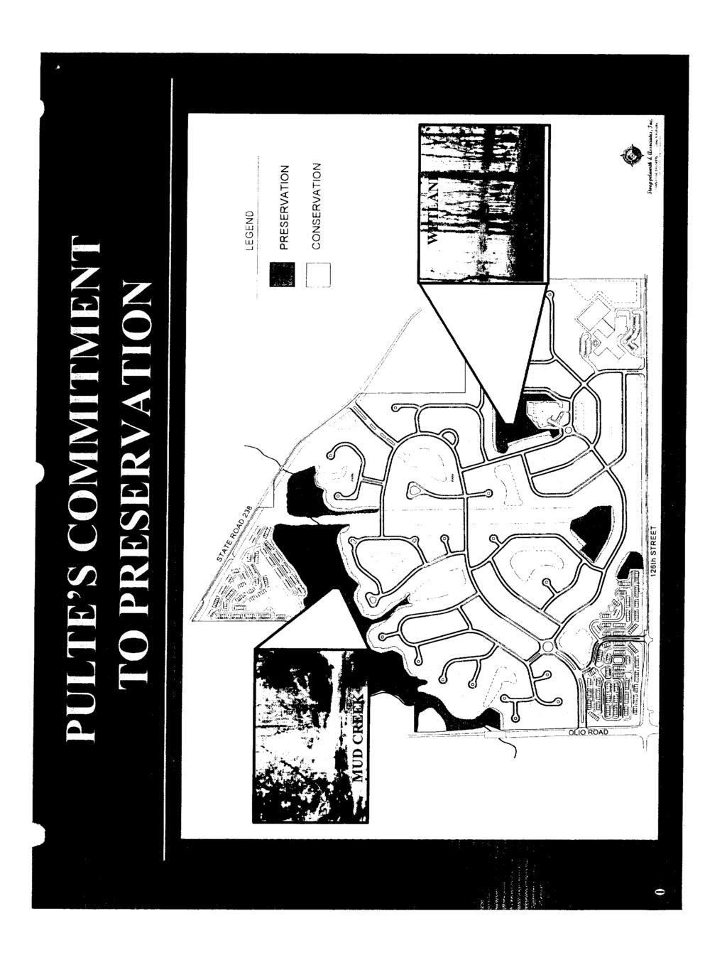
2 TABLE OF CONTENTS Pond Right of Way College Park Church Proposed Church +/- 1978' Petitioner: Chris Beals, Fishers Campus Lead Pastor College Park Church, Inc West 96th Street Indianapolis, IN telephone Attorney: Steven D. Hardin, Esq. Rex A. Ramage, Land Use Consultant Faegre Baker Daniels, LLP 600 East 96th Street, Suite 600 Indianapolis, Indiana telephone fax Tab 1 Tab 2 Tab 3 Tab 4 Tab 5 Tab 6 TABLE OF CONTENTS Executive Summary Aerial Location Exhibit Concept Plan Comparison Proposed PUD Ordinance Amendment Existing 2003 Avalon Ordinance 2003 Commitments
3 TAB 1
4 EXECUTIVE SUMMARY Pond Right of Way College Park Church Proposed Church +/- 1978' College Park Church, Inc. (the Church ) respec ully submits its request for an amendment to the Avalon PUD Ordinance for its proposed new Fishers campus. The 37-acre site is located on the west side of Southeastern Parkway, just south of 136th Street (please see the aerial loca on map at Tab 2). About the Church In 1985, 10 families established the Church in a local hotel conference room. Since that me, the Church has grown into its 31-acre Carmel campus located at 96th Street and Towne Road where an average of 4,000 community members worship in Sunday a endance. Within the Church, the members are engaged in a variety of ministries, including offerings for children, families, counseling, Bible studies, small groups, the arts, theological training, and leadership development. Beyond its walls, the Church invests in gospel-centered ministry to the unreached, underserved, and unchurched. Regionally, the Church has fostered strategic partnerships with organiza ons such as Midwest Food Bank, Neighborhood Chris an Legal Clinic, Purposeful Design, Nehemiah Bible Church (Indy near-east side), The Oaks Academy, Safe Families, and Shepherd Community Center. Globally, the Church invests in the world through partnerships and ini a ves focused on schools, hospitals, human trafficking, relief aid, economic & community development, and Bible transla on. Approximately 800 of the Church s regular a endees and members live in the Fishers area, most of them are families who are ac vely engaged in the Fishers community. A commi ed core group of approximately 300 people already is worshiping together weekly in prepara on for launching the Fishers campus. This group started mee ng in February and began worshiping in August in Fall Creek Intermediate School. A summary of the Church s vision can be seen here: www. yourchurch.com/nextdoormission About the Site The exis ng 2003 Avalon PUD Ordinance contemplated 186 townhomes to be built on this site (please see original concept plan at Tab 3). The townhome market never developed, and this site has remained dormant since The Church now is the contract-purchaser from Pulte Homes, the original developer. When the Church approached the City about the proposed development, the City encouraged the Church to incorporate some commercial uses into the master plan. In response, the Church designed a plan that provides about 4.2 acres of commercial uses in the northwest corner of the site, while preserving an aesthe cally pleasing master plan for the Church, its members and the community. The proposed Concept Plan may be found at Tab 3. About this Request Procedurally, the Church now is reques ng a text amendment to the exis ng Avalon PUD Ordinance to permit the church use and the commercial uses as proposed. The proposed PUD Ordinance may be found at Tab 4.
5 EXECUTIVE SUMMARY Pond Right of Way College Park Church Recent Updates Proposed Church +/- 1978' The Plan Commission considered this request at the December 15, 2015, Plan Commission mee ng. A er conduc ng the public hearing, the Plan Commission voted unanimously to forward this proposal to the City Council with a favorable recommenda on. Thank you for your considera on.
6 TAB 2

7 AERIAL LOCATION EXHIBIT Pond Right of Way College Park Church Proposed Church +/- 1978' Interstate th Street Olio Road Southeastern Pkwy 126th Street Site N
8 TAB 3


9 CONCEPT PLAN COMPARISON Pond Right of Way College Park Church Proposed Church +/- 1978' 2003 CONCEPT PLAN 2015 PROPOSED CONCEPT PLAN
10 TAB 4
11 Year 2015 COLLEGE PARK CHURCH PUD City of Fishers Planned Development Ordinance No
12 COLLEGE PARK CHURCH PUD 1.01 Declaration, Purpose and Intent, and Permitted Uses Declaration Ordinance No (this Ordinance") Adopted: The Unified Development Ordinance (the "UDO") of the City of Fishers, Indiana, Ordinance No A, as amended, and the OFFICIAL ZONING MAP, CITY OF FISHERS, INDIANA, dated October 16, 2006, as amended, which accompanies and is a part of the Zoning Code of the City of Fishers, Indiana, are hereby amended as follows: The zoning classification of the real estate legally described in Section 1.09 of this Ordinance (the "Real Estate"), is hereby designated as a Planned Unit Development - Mixed (PUD-M), and that said PUD-M zoning district shall hereafter be known as the "College Park Church PUD." If the Real Estate is developed pursuant to this Ordinance, then development of the Real Estate shall be governed entirely by the provisions of this Ordinance and those provisions of the UDO specifically referenced in this Ordinance. If the Real Estate is not developed pursuant to this ordinance, then the existing ordinance ( and G) shall continue to govern the Real Estate. Purpose and Intent The purpose of this PUD is to encourage improved design in the development of land by promoting greater flexibility in applying the Ordinance to the development of the Real Estate. Permitted Uses Year 2015 Area A: All uses described in the Commercial District except those uses that are: (i) struck through below; or (ii) an Excluded Use. Accessory Uses: accessory use subordinate to the primary use of the building satellite television receiving-only antenna Commercial and Service Uses: art and antique shop bakery coffee shop confectionery dance studio day care, adult day care, child dry cleaner (pick-up station only) flower shop fuel sales* fuel/energy station gift shop grocery/convenience mart hardware store health food store mortuary office supply store package goods store (alcohol) personal body services personal care services pharmacy/nutrition store photography shop restaurant, deli-style and ice cream shop/parlor* restaurant, family restaurant, fast food/quick service* restaurant, fine dining restaurant, takeout* retail, low intensity retail, very low intensity retail shop, specialty sewing, art, or craft supply store veterinary clinic Institutional Uses: civic club or recreational facility community center government office and building library place of worship public safety facility school; trade, business or commercial; pre-kindergarten Office Uses: bank, credit union, financial services or savings and loan financial office general office medical office Residential Uses: nursing and convalescent home Excluded Uses: Institutional Uses or other uses that cause the Real Estate to be exempt from paying Indiana property taxes. Area B: All uses described in the Residential District. 2 City of Fishers PUD District Ordinance


: Amendments to the Unified Development Ordinance, an amendment to the UDO shall apply to this Ordinance unless this Ordinance has specified an alternative development or design standard, and")
13 COLLEGE PARK CHURCH PUD Year Applicability A. The standards of the UDO applicable to the Commercial District shall apply to the development of Area A, and the standards of the UDO applicable to the Residential District shall apply to the development of Area B as shown on the Area Map, attached hereto as Exhibit A, except as modified, revised, or expressly made inapplicable by this Ordinance. "Article" cross-references of this Ordinance shall hereafter refer to the Article section as specified and referenced in the UDO. Capitalized terms that are not otherwise defined herein shall have the meaning ascribed to them in the UDO. Pursuant to Article 4.02(F): Amendments to the Unified Development Ordinance, an amendment to the UDO shall apply to this Ordinance unless this Ordinance has specified an alternative development or design standard, and Article 1.10: Basic Provisions: Transition Rules also shall apply to amendments Concept Plan A. The Concept Plan is hereby incorporated. The Real Estate's development plan may vary from the Concept Plan; however, per Article 9.17(A)(2)(a): Planned Unit Development District; General; Purpose & Intent, the Concept Plan provides the Plan Commission and City Council with a general vision for the development of the Real Estate. Conservation Area N City of Fishers PUD District Ordinance 3
14 COLLEGE PARK CHURCH PUD Year Development Standards A. Cross References: The regulations of Article 05: Development Standards shall apply, except as modified by this Ordinance. B. General Regulations: Article 2.08: R2 Residential District Development Standards and Article 2.26: C2 Commercial District Development Standards shall apply. C. Accessory Structure Standards (AS): shall apply. D. Architectural Design Standards (AD): shall apply: E. Density & Intensity Standards (DI): shall apply. F. Entrance & Driveway Standards (ED): shall apply. G. Environmental Standards (EN): shall apply. H. Fence & Wall Standards (FW): shall apply. I. Floodplain Standards (FP): shall apply. J. Floor Area Standards (FA): shall apply. K. Height Standards (HT): shall apply. L. Home Occupation Standards (HO): shall apply. M. Landscaping Standards (LA): shall apply. In addition, the following shall apply: Conservation Area: (1) The term Conservation Area shall mean and refer to the areas identified on the Concept Plan as Conservation Areas. These Conservation Areas shall be located generally in the areas identified on the Concept Plan; however, the exact area of the Conservation Area shall be designated at the time of final development plan submittal by the owner of the Real Estate (the Owner ), in the Owner s sole discretion. Prior to issuance of an improvement location permit for the Real Estate, the Owner shall record in the Office of the Recorder of Hamilton County, Indiana, a Conservation Easement, defined below, applicable to the Conservation Areas. (2) The term Conservation Easement shall mean and refer to those places on a lot or development that are identified for the purpose of protecting certain elements or the land and/or natural vegetation. Plant life may be removed from a conservation easement if a plant or tree is dead, dying, diseased, or poses a threat to health, safety, and/or welfare. Small vegetation and underbrush may be removed at any time to aid in the creation of usable spaces for trails, paths, picnic shelters, and the like. Evergreen trees eight (8) feet or less, in height, and deciduous trees with a caliper measurement of less than four (4) inches may also be removed to aid in the creation of the usable spaces for trails, paths, picnic shelters, and the like, but must be done in a manner to cause as little removal and/or damage as possible. Any individual or entity seeking to remove such trees shall have the approval of the Department of Community Development staff prior to the removal of said trees. The City of Fishers may be permitted to do limited work in Conservation Easements only at the direction of the City Council. Plants and trees may be removed from within the Conservation Easement if reasonably necessary in order to accommodate utilities, drainage or other infrastructure; however, (i) such removal must be done in a manner to cause as little removal and/or damage as possible, and (ii) any individual or entity seeking to remove such trees shall have the approval of the Department of Community Development staff prior to the removal of said trees, which approval shall not be withheld or delayed unreasonably. N. Lighting Standards (LT): shall apply. O. Loading Standards (LD): shall apply. P. Lot Standards (LO): shall apply. Q. Outdoor Storage Standards (OS): shall apply. R. Parking Standards (PK): shall apply. S. Pedestrian Accessibility Standards (PA): shall apply. T. Performance Standards (PF): shall apply. U. Permanent Outdoor Display Area Standards (PD): shall apply. V. Property Identification Standards (PI): shall apply. W. Public Art Standards (PT): shall apply. X. Public Improvement Standards (PV): shall apply. 4 City of Fishers PUD District Ordinance
15 COLLEGE PARK CHURCH PUD Y. Setback Standards (SB): shall apply. Z. Sewer & Water Standards (SW): shall apply. AA. Sexually Oriented Business Standards (SX): shall apply. BB. Sign Standards (SG): shall apply. CC. Structure Quantity Standards (SQ): shall apply. DD. Telecommunication Facilities Standards (TC): shall apply. EE. Temporary Use/Structure Standards (TU): shall apply. FF. Use-specific Standards (US): shall apply. GG. Vision Clearance Standards (VC): shall apply. Year Design Standards A. Cross References: The regulations of Article 7: Design Standards applicable to a Planned Unit Development (PUD) shall apply except as modified by this Ordinance: B. Access Road Standards (AC): shall apply. C. Alley Standards (AL): shall apply. D. Anti-monotony Standards (AM): shall apply. E. Common Area Standards (CA): shall apply. F. Covenant Standards (CE): shall apply. G. Dedication of Public Improvement Standards (DD): shall apply. H. Density and Intensity Standards (DE): shall apply. I. Development Name Standards (DN): shall apply. J. Easement Standards (EA): shall apply. K. Erosion Control Standards (EC): shall apply. L. Floodplain Standards (FL): shall apply. M. Lot Establishment Standards (LT): shall apply. N. Mixed Use Development Standards (MU): shall apply. O. Monument & Marker Standards (MM): shall apply. P. On-street Parking Standards (OG): shall apply. Q. Open Space Standards (OP): shall apply. In addition, any unimproved areas of the Real Estate shall qualify as open space as permitted per Article 7.25 (C)(6) OP-01: Open Space Standards; Residential; Site Features that Qualify as Open Space; City Council-approved Open Space. R. Pedestrian Network Standards (PN): shall apply. S. Perimeter Landscaping Standards (PL): shall apply. T. Prerequisite Standards (PQ): shall apply. U. Storm Water Standards (SM): shall apply. V. Street & Right-of-way Standards (SR): shall apply. W. Street Lighting Standards (SL): shall apply. X. Street Name Standards (SN): shall apply. Y. Street Sign Standards (SS): shall apply. Z. Surety Standards (SY): shall apply. AA. Utility Standards (UT): shall apply Procedures A. The procedures set forth in Article 9: Processes, Permits & Fees; Planned Unit Development shall apply. Development plans shall be reviewed and approved based upon compliance with the development and design standards set forth herein. B. The Real Estate shall be assigned to the City's general PUD Committee (the "Committee") for review pursuant to Article 9.20 Planned Unit Development; Final Development Plan. C. The Committee shall have discretion and flexibility to consider and approve modifications pertaining to architecture, signage, and landscaping design standards established or referenced by this Ordinance if the Committee determines such modifications are consistent with the intent of this Ordinance and consistent with the quality and character represented in this Ordinance. City of Fishers PUD District Ordinance 5
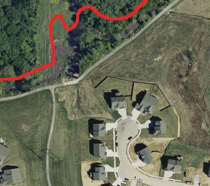
16 COLLEGE PARK CHURCH PUD Year Previous Commitments Certain Commitments, as amended, cconcerning the Use and ddevelopment of the Real Estate, recorded June 27, 2003, as Instrument Number , and the Amendment to Commitments Concerning the Use and Development of Real Estate, recorded August 25, 2003, as Intrument Number , in the office of the Recorder of Hamilton County, were made in connection with the approvals obtained by Ordinance Nos and G (related to the development of townhomes, Conservation Area, and Preservation Area on the Real Estate) (together, the Commitments ). With respect to the Real Estate, the Commitments created townhome design standards and made provisions for the conservation and preservation of trees. Those ttree Conservation Area standards applicable to the Real Estate now are incorporated into this Ordinance, and the Commitments hereby are terminated with respect to the Real Estate, as approved by the Plan Commission. The Commitments placed certain restrictions on certain design standards, the Conservation Area, and the Preservation Area on the Real Estate. Those restrictions applicable to the Real Estate are now incorporated into this Ordinance, and the Commitments hereby are terminated, as approved by the Plan Commission. The restrictions now are set forth below: (i) Conservation Area Commitments: (1) Except as noted immediately below, each builder and/or Developer shall endeavor to conserve trees within the Conservation Area, and owners of lots shall not remove trees within Conservation Areas: (a) The clearing of underbrush, as defi ned and determined by the Developer's certified arborist, and the clearing of dead trees shall be allowed; (b) The removal of trees necessary for the installation of utilities, walking trails, and drainage improvements and infrastructure shall be allowed; and (c) Trees may be removed as necessary for public health and safety. Except as set forth immediately above in subparagraphs A, B, and C, each tree within the Conservation Area which is badly damaged or destroyed by a lot owner or during the course of construction activities and which is greater than four (4) inches in diameter, measured six (6) inches above the ground, shall be replaced within one (1) year, by the person or entity causing such damage or destruction, with a tree which is at least two and one-half (2-1/2) inches in diameter measured six (6) inches above the ground. Any trees which are so replaced and which die within one (1) year of their planting shall promptly be replaced with a substantially similar tree. (ii) Preservation Area Commitments: (1) Preservation areas shall be owned and maintained by the Homeowners Association as a common area, and residential construction shall not occur within the Preservation Areas. Except as noted immediately below, each builder and/or developer shall endeavor to preserve trees within the Preservation Areas, and the owners of lots shall not remove trees within the Preservation Areas: (a) The clearing of underbrush and dead trees shall be allowed; (b) The removal of trees necessary for the installation of utilities, drainage improvements and infrastructure, and trails shall be allowed; and (c) The removal of trees for public health and safety shall be allowed. Except as set forth in paragraphs A, B, and C immediately above, each tree within the Preservation Area which is badly damaged or destroyed by a lot owner or during the course of construction activities and which is greater than four (4) inches in diameter, measured six (6) inches above the ground, shall be replaced within one (1) year, by the person or entity causing such damage or destruction, with a tree which is at least two and one-half (2-1/2) inches in diameter measured six (6) inches above the ground. Any trees which are so replaced and which die within one (1) year of their planting shall promptly be replaced with a substantially similar tree. (2) Subject only to alteration and tree removal in order to accommodate drainage, utilities, and trails, the fl ood plain along Mud Creek shall be maintained in its natural state, to the best of the Developer's ability; and (3) The Developer shall install a twelve (12) foot asphalt path, consistent with the Town's perimeter path specifi cations. The Developer shall dedicate to the Town of Fishers this twelve (12) foot asphalt path, together with a ten (10) foot wide easement on each side of the path. The Town of Fishers shall maintain the path upon acceptance of the dedication thereof. The location of the path shall be determined by the Developer, but shall follow the line of Mud Creek along the route of the interceptor sewer. 6 City of Fishers PUD District Ordinance
17 COLLEGE PARK CHURCH PUD Year Adoption This ordinance shall be in full force and effect from and after its passage by the Common Council and after the occurrence of all other actions required by law. All provisions or parts of the UDO in conflict herewith are hereby repealed. APPROVED by the Common Council of the City of Fishers this day of, THE COMMON COUNCIL OF THE CITY OF FISHERS, HAMILTON COUNTY, INDIANA AYE NAY C. Pete Peterson, President John W. Weingardt, Vice-President David C. George, Member Eric Moeller, Member Selina M. Stoller, Member Richard W. Block, Member Cecilia C. Coble, Member Todd P. Zimmerman, Member Brad DeReamer, Member I hereby certify that the foregoing Ordinance was delivered to City of Fishers Mayor Scott Fadness on the day of 2016, at m. ATTEST: Jennifer L. Kehl, City Clerk MAYOR S APPROVAL Scott A. Fadness, Mayor DATE Approved by: Chris Greisl, City of Fishers, City Attorney Prepared by: Steven D. Hardin, Esq., Faegre Baker Daniels LLP, 600 East 96th Street, Suite 600, Indianapolis, Indiana (317) In accordance with Indiana Code, I affirm, under penalties for perjury, that I have taken reasonable care to redact each Social Security number in this document, unless required by law: Steven D. Hardin, Esq. 7 City of Fishers PUD District Ordinance
18 COLLEGE PARK CHURCH PUD 1.09 Real Estate Year 2015 Part of the east half of the northwest quarter and part of the west half of the northeast quarter of section 25, township 18 north, range 5 east of the second principal meridian, Hamilton County, Indiana being more particularly described as follows: Commencing at the northwest corner of said east half; thence on the west line of said east half south 00 degrees 12 minutes 40 seconds east (assumed basis of bearings) feet to a 5/8 inch diameter rebar with a yellow plastic cap stamped weihe engr (hereinafter weihe rebar ) on the southwesterly rightof-way line of southeastern parkway per the right-of-way plans for Indiana Department of Transportation project no. stp-3229(005) being the point of beginning; thence continuing on said west line south 00 degrees 12 minutes 40 seconds east feet and passing through a weihe rebar at feet to the thread of Mud Creek; thence on said thread the following twenty four (24 calls): 1) north 83 degrees 17 minutes 18 seconds east feet; 2) south 66 degrees 14 minutes 52 seconds east feet; 3) north 57 degrees 21 minutes 29 seconds east feet; 4) north 13 degrees 43 minutes 06 seconds east feet; 5) north 28 degrees 34 minutes 33 seconds east feet; 6) north 63 degrees 41 minutes 56 seconds east feet; 7) south 49 degrees 03 minutes 48 seconds east feet; 8) north 75 degrees 23 minutes 59 seconds east feet; 9) north 86 degrees 00 minutes 14 seconds east feet; 10) north 63 degrees 47 minutes 11 seconds east feet; 11) north 88 degrees 31 minutes 16 seconds east feet; 12) north 68 degrees 59 minutes 57 seconds east feet; 13) north 16 degrees 54 minutes 41 seconds west feet; 14) north 47 degrees 08 minutes 30 seconds east feet; 15) south 42 degrees 35 minutes 40 seconds east feet; 16) north 55 degrees 01 minute 39 seconds east feet; 17) north 07 degrees 40 minutes 05 seconds west feet; 18) north 60 degrees 54 minutes 44 seconds east feet; 19) south 65 degrees 09 minutes 57 seconds east feet; 20) south 67 degrees 08 minutes 29 seconds east feet; 21) north 76 degrees 18 minutes 31 seconds east feet; 22) north 51 degrees 04 minutes 37 seconds east feet; 23) north 43 degrees 08 minutes 47 seconds east feet; 24) north 27 degrees 58 minutes 14 seconds east feet to said southwesterly right-of-way line of southeastern parkway; thence along said line north 65 degrees 41 minutes 44 seconds west feet and passing through a weihe rebar at feet; thence continuing on said line north 55 degrees 52 minutes 00 seconds west feet to a point being feet south of the north line of said northeast quarter as measured parallel with the west line of said northeast quarter; thence continuing on said rightof- way line and parallel with the north line of said northeast quarter south 89 degrees 34 minutes 01 second west feet to the east line of said northwest quarter; thence on said east line and said right-of-way line north 00 degrees 11 minutes 56 seconds west feet to a weihe rebar; thence continuing on said right-of-way line the following four (4) calls: 1)north 58 degrees 35 minutes 08 seconds west feet; 2) north 62 degrees 13 minutes 12 seconds west feet; (3) north 59 degrees 05 minutes 26 seconds west feet; 4)north 56 degrees 16 minutes 25 seconds west feet to the point of beginning, containing acres, more or less. City of Fishers PUD District Ordinance 8


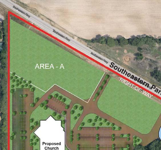
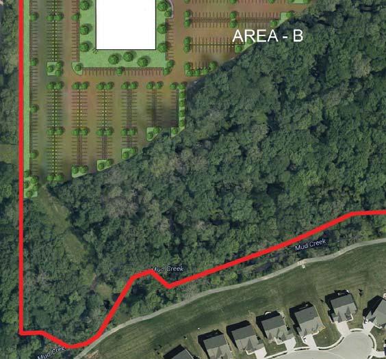
19 Exhibit A: Area Map Area A: Up to 4.2 +/- acres to be located generally in the northwest corner of the Real Estate. This Area may be extended up to 900 along Southeastern Parkway and along the Real Estate s west boundary. Area B: Approximately 33 +/- acres. +/- 1840' Area - A +/- 4.2 Acres Southeastern Parkway Right of Way +/- 1978' Area - B +/-33.3 Acres
20 TAB 5
21
22
23
24
25
26
27
28
29
30
31
32
33
34
35
36
37
38
39
40
41 TAB 6
42
43
44
45
46
47
48
49
50
51
52
53
54
Year. Simply Dental PUD. Town of Fishers Planned Development Ordinance No v
 Simply Dental PUD v. 02.03.14 Town of Fishers Planned Development Ordinance No. 010614 1.01 Declaration, Purpose and Intent, and Permitted Uses Declaration Ordinance No. 010614 (this Ordinance") Adopted:
ORDINANCE NO. AN ORDINANCE AMENDING THE ZONING ORDINANCE OF FISHERS, INDIANA 2006
 ORDINANCE NO. AN ORDINANCE AMENDING THE ZONING ORDINANCE OF FISHERS, INDIANA 2006 AN ORDINANCE AMENDING THE ZONING ORDINANCE OF FISHERS, INDIANA 2006. BE IT ORDAINED BY THE TOWN COUNCIL OF THE TOWN OF
GEIST MANOR PUD. City Council 3 rd Reading. Gravel Trail. Paved Trail. Trailhead. Open Field. Woods. Playground. Canoe Launch. Firepit.
 146th St E 116th St E 104th St GEIST MANOR PUD City Council 3 rd Reading Florid Florida Road Road 113 St. 113th Street PARK N PKWY TO PENDLETON Geist Park RTH 113TH STREET Regional Map Legend GEIST PARK
ORDINANACE NO
 ORDINANACE NO. 082018 AN ORDINANCE ADJUSTING RATES AND CHARGES FOR THE USE OF AND SERVICES RENDERED BY THE CITY OF FISHERS, INDIANA STORMWATER UTILITY SYSTEM WHEREAS, the City of Fishers, Hamilton County,
ANDERSON HALL PUD TEXT AMENDMENT PRESENTED BY STEVEN D. HARDIN, ESQ.
 ANDERSON HALL PUD TEXT AMENDMENT PRESENTED BY STEVEN D. HARDIN, ESQ. TOWN COUNCIL REQUEST FOR THIRD READING MARCH 17, 2014 TABLE OF CONTENTS 141ST STREET & PROMISE ROAD PUD Petitioner Craig H. Lintner
Subdivision, Development Plan and PUD Design Standards Porter County Unified Development Ordinance
 Chapter Subdivision, Development Plan and PUD Design Standards Porter County Unified Development Ordinance 20 Bradley E. Johnson, AICP website www.groundrulesinc.com Design Standards Section Name Page
Article. Table of Contents City of Birmingham Zoning Ordinance. 2006, Bradley E. Johnson, AICP
 00 Table of Contents City of Birmingham Zoning Ordinance 2006, Bradley E. Johnson, AICP Table of Contents One: Zoning Ordinance Foundation Page # 1.01 Title... 1-2 1.02 Defined Words... 1-2 1.03 Authority...
Chapter. Subdivision Regulations Porter County Unified Development Ordinance. website Bradley E.
 Subdivision Regulations Porter County Unified Development Ordinance 2007 Bradley E. Johnson, AICP website www.groundrulesinc.com Conventional Subdivision (CV) 6.01 Conventional Subdivision Intent The Conventional
Article. Table of Contents Town of Fishers Unified Development Ordinance. 2013, Bradley E. Johnson, AICP
 00 Table of Contents Town of Fishers Unified Development Ordinance 2013, Bradley E. Johnson, AICP Table of Contents 00 1: Ordinance Foundation 1.01 Title... 1-2 1.02 Defined Words... 1-2 1.03 Authority...
FLATS AT 146. Replat and Amendment to a Multi-family Planned Development DOMO DEVELOPMENT, LLC PRESENTED BY STEVEN D. HARDIN, ESQ.
 Replat and Amendment to a Multi-family Planned Development DOMO DEVELOPMENT, LLC PRESENTED BY STEVEN D. HARDIN, ESQ. NOBLESVILLE PLAN COMMISSION JUNE 16, 2014 TABLE OF CONTENTS Petitioner DOMO Development
3.92 Acres Chesterfield County, VA
 3.92 Acres Chesterfield County, VA ASKING PRICE - $154,500 Represented By: William G. Grant ALC. VLS (804) 754-3476 JEFFREY S. HUFF ALC, FORESTER (804) 750-1207 Table of Contents I. Property Description
Foreword. Table of Contents Porter County Unified Development Ordinance. website Bradley E.
 Table of Contents Porter County Unified Development Ordinance 2007 Bradley E. Johnson, AICP website www.groundrulesinc.com ii Porter County, Indiana Unified Development Ordinance Table of Contents Chapter
ORDINANCE NO BROWNSBURG, INDIANA, 2014
 ORDINANCE NO. 2013-33 BROWNSBURG, INDIANA, 2014 AN ORDINANCE TO AMEND ARTICLES 1, 2, 4, 5, 7, AND 9, 1.01 (I)(1) ZONING ORDINANCE, 1.03 (B) LOCATION, 1.04 PLAN COMMISSION CERTIFICATION, 1.05 TOWN COUNCIL
CHAPTER XI C-1 NEIGHBORHOOD BUSINESS DISTRICT
 CHAPTER XI C-1 NEIGHBORHOOD BUSINESS DISTRICT Section 11.1 Description and Purpose. The C-1 Neighborhood Business District is intended for neighborhood convenience shopping and for office purposes, with
CHAPTER XII C-2 GENERAL BUSINESS DISTRICT
 CHAPTER XII C-2 GENERAL BUSINESS DISTRICT Section 12.1 Description and Purpose. The C-2 General Business District is intended for general shopping areas, including retail businesses or service establishments
PERSIMMON GROVE. Developer Pulte Group North Meridian Street, Suite 530 Carmel, IN 46032
 PERSIMMON GROVE A RESIDENTIAL PLANNED UNIT DEVELOPMENT In Avon, Indiana Developer Pulte Group 11590 North Meridian Street, Suite 530 Carmel, IN 46032 Attorney Comer Law Office Ben Comer 71 West Marion
CITY OF PALMDALE COUNTY OF LOS ANGELES, CALIFORNIA RESOLUTION NO. CC
 CITY OF PALMDALE COUNTY OF LOS ANGELES, CALIFORNIA RESOLUTION NO. CC 2011-118 A RESOLUTION OF THE CITY COUNCIL OF THE CITY OF PALMDALE, CALIFORNIA, UPHOLDING THE PLANNING COMMISSION APPROVAL OF CONDITIONAL
Charter Township of Plymouth Zoning Ordinance No. 99 Page 58 Article 11: OS-ARC Office Service-Ann Arbor Road Corridor District ARTICLE XI OS-ARC
 Charter Township of Plymouth Zoning Ordinance No. 99 Page 58 PURPOSE ARTICLE XI OS-ARC OFFICE SERVICE ANN ARBOR ROAD CORRIDOR DISTRICT Recognizing the importance of a viable Ann Arbor Road Corridor with
(a) Commercial uses on Laurel Avenue, abutting the TRO District to the
 Commercial uses on Laurel Avenue, abutting the TRO District to the") 32X Zoning Code 150.36 TRANSITIONAL RESIDENTIAL OVERLAY DISTRICT. (A) Intent and purpose. (1) It is the intent of the Transitional Residential Overlay District (hereinafter referred to as the "TRO District")
32X Zoning Code 150.36 TRANSITIONAL RESIDENTIAL OVERLAY DISTRICT. (A) Intent and purpose. (1) It is the intent of the Transitional Residential Overlay District (hereinafter referred to as the "TRO District")
SECTION 10.7 R-PUD (RESIDENTIAL PLANNED UNIT DEVELOPMENT) ZONE
 ZONE") Article X Zones 10-20 SECTION 10.7 R-PUD (RESIDENTIAL PLANNED UNIT DEVELOPMENT) ZONE A. PURPOSE AND INTENT: The R-PUD Residential PUD Zone is intended to provide alternative, voluntary zoning procedures
Article X Zones 10-20 SECTION 10.7 R-PUD (RESIDENTIAL PLANNED UNIT DEVELOPMENT) ZONE A. PURPOSE AND INTENT: The R-PUD Residential PUD Zone is intended to provide alternative, voluntary zoning procedures
TOWNSHIP OF ALGOMA COUNTY OF KENT, MICHIGAN. Minutes of a regular meeting of the Township Board of the Township of Algoma, Kent
 Site Plan No. 0410 --- TOWNSHIP OF ALGOMA COUNTY OF KENT, MICHIGAN Minutes of a regular meeting of the Township Board of the Township of Algoma, Kent County, Michigan, held in the Algoma Township Hall,
PLANNED UNIT DEVELOPMENTS (Ordinance No.: 3036, 12/3/07; Repealed & Replaced by Ordinance No.: 4166, 10/15/12)
") 159.62 PLANNED UNIT DEVELOPMENTS (Ordinance No.: 3036, 12/3/07; Repealed & Replaced by Ordinance No.: 4166, 10/15/12) A. PURPOSE 1. General. The Planned Unit Development (PUD) approach provides the flexibility
159.62 PLANNED UNIT DEVELOPMENTS (Ordinance No.: 3036, 12/3/07; Repealed & Replaced by Ordinance No.: 4166, 10/15/12) A. PURPOSE 1. General. The Planned Unit Development (PUD) approach provides the flexibility
TOWNSHIP OF ALGOMA. County, Michigan, held in the Algoma Township Hall, Algoma Avenue, N.E., within
 TOWNSHIP OF ALGOMA COUNTY OF KENT, MICHIGAN At a special meeting of the Township Board of the Township of Algoma, Kent County, Michigan, held in the Algoma Township Hall, 10531 Algoma Avenue, N.E., within
VILLAGE OF LAKE ZURICH ORDINANCE NO
 VILLAGE OF LAKE ZURICH ORDINANCE NO. 2018-05-257 AN ORDINANCE GRANTING APPROVAL FOR A PLANNED UNIT DEVELOPMENT, DEVELOPMENT CONCEPT PLAN, SPECIAL USE PERMITS, AND MODIFICATIONS TO THE ZONING AND LAND DEVELOPMENT
CITY OF SARATOGA SPRINGS ZONING ORDINANCE
 Appendix C: 8. The Village At Saratoga Planned Unit Development (formerly 241.8) Chapter 241.8 AN ORDINANCE PROVIDING FOR THE ESTABLISHMENT OF A PLANNED UNIT DEVELOPMENT DISTRICT TO BE KNOWN AS "THE VILLAGE
ARTICLE 9 C-B - COMMERCIAL-BUSINESS DISTRICT
 Section 901. PURPOSE ARTICLE 9 C-B - COMMERCIAL-BUSINESS DISTRICT The Commercial-Business (C-B) District is established to provide development opportunities for mixed use business and highway oriented
Town Center South End Development Area District
 175.28 ESTABLISHMENT OF DISTRICTS. In order to carry out the purpose and intent of this chapter, the area of the is hereby divided into eighteen (18) Zoning District Classifications and one overlay zoning
Division Development Impact Review.
 Division 51-4.800. Development Impact Review. SEC. 51-4.801. PURPOSE. The general objectives of this division are to promote and protect the health, safety, and general welfare of the public through the
BEAR CREEK TOWNSHIP EMMET COUNTY, MICHIGAN. PRIVATE ROAD ORDINANCE Ordinance No. 11A-99. (to replace prior Private Road Ordinance No.
 BEAR CREEK TOWNSHIP EMMET COUNTY, MICHIGAN PRIVATE ROAD ORDINANCE Ordinance No. 11A-99 (to replace prior Private Road Ordinance No. 11-99) An Ordinance to protect the health, safety, and general welfare
ARTICLE 847. PD 847. PD 847 was established by Ordinance No , passed by the Dallas City Council on April 27, (Ord.
 ARTICLE 847. PD 847. SEC. 51P-847.101. LEGISLATIVE HISTORY. PD 847 was established by Ordinance No. 28186, passed by the Dallas City Council on April 27, 2011. (Ord. 28186) SEC. 51P-847.102. PROPERTY LOCATION
THE CITY COUNCIL OF NORTH ROYALTON, OHIO
 THE CITY COUNCIL OF NORTH ROYALTON, OHIO ORDINANCE NO. 16-113 INTRODUCED BY: Nickell, Kasaris, Antoskiewicz AN ORDINANCE AMENDING THE CODIFIED ORDINANCES OF THE CITY OF NORTH ROYALTON, PART 12 PLANNING
PUD Ordinance - Thornapple Manor #2 of 1998
 PUD Ordinance - Thornapple Manor #2 of 1998 CASCADE CHARTER TOWNSHIP Ordinance #2 of 1998 AN ORDINANCE TO AMEND THE CASCADE CHARTER TOWNSHIP ZONING ORDINANCE AND ZONING MAP TO ESTABLISH THORNAPPLE MANOR
ORDINANCE WHEREAS, the adoption of this Ordinance shall not be construed as an admission that the aforesaid claim has merit or is correct; and
 ORDINANCE 12-24 AN ORDINANCE OF THE CITY OF WINTER GARDEN, FLORIDA, REPEALING ORDINANCE 12-02 AND REPLACING IT WITH THE AMENDMENTS TO ARTICLE V OF CHAPTER 118 OF THE WINTER GARDEN CODE OF ORDINANCES CONTAINED
PUD Ordinance - Cascade Lakes Plat #10 of 1995
 PUD Ordinance - Cascade Lakes Plat #10 of 1995 CASCADE CHARTER TOWNSHIP Ordinance #10 of 1995 AN ORDINANCE TO AMEND THE CASCADE CHARTER TOWNSHIP ZONING ORDINANCE AND ZONING MAP TO ESTABLISH THE CASCADE
PROPOSED AMENDMENTS TO THE DERBY ZONING REGULATIONS AUGUST 12, 2008
 ARTICLE II Definitions and word usage 195-7. Definitions and word usage. Modify the following: HOUSING FOR THE ELDERLY OLDER PERSONS Housing in accordance with and as defined in the United States Fair
CITY OF NORTH OAKS COUNTY OF RAMSEY STATE OF MINNESOTA ORDINANCE NO. 109 AN ORDINANCE IMPLEMENTING THE CHARLEY LAKE PRESERVE PLANNED UNIT DEVELOPMENT
 CITY OF NORTH OAKS COUNTY OF RAMSEY STATE OF MINNESOTA ORDINANCE NO. 109 AN ORDINANCE IMPLEMENTING THE CHARLEY LAKE PRESERVE PLANNED UNIT DEVELOPMENT The City of North Oaks hereby ordains as follows: SECTION
AN ORDINANCE TO CREATE THE ALDEN RIDGE PUD As Recommended to the Lowell Township Board by the Lowell Township Planning Commission January 11, 2016
 CHARTER TOWNSHIP OF LOWELL COUNTY OF KENT, MICHIGAN AN ORDINANCE TO CREATE THE ALDEN RIDGE PUD As Recommended to the Lowell Township Board by the Lowell Township Planning Commission January 11, 2016 At
Ontario Municipal Board Decision issued July 28, 2014 and Orders issued December 4 and 17, 2015 in Board File No. PL CITY OF TORONTO
 Authority: Ontario Municipal Board Decision issued July 28, 2014 and Orders issued December 4 and 17, 2015 in Board File No. PL131305 CITY OF TORONTO BY-LAW No. 673-2016(OMB) To amend Chapters 304, 320
SHORT PLAT Information
 Information This form provides information and an explanation of the procedures of a Short Plat. If you have any questions, contact the Planning and Development Services Department at (253) 566-5656. A
BYRON TOWNSHIP ZONING APPLICATION
 BYRON TOWNSHIP ZONING APPLICATION Phone: (616) 878-9104 * Fax: (616) 878-3980 * Website: www.byrontownship.org This application will not be accepted if incomplete. APPLICATION FOR & REQUIRED COPIES Private
CITRUS HEIGHTS COMMUNITY SPECIAL PLANNING AREA
 CITRUS HEIGHTS COMMUNITY SPECIAL PLANNING AREA 501-90. INTENT. It is the intent of the Board of Supervisors in adopting this Special Planning Area Ordinance to allow development on the property described
CHARTER TOWNSHIP OF GRAND RAPIDS COUNTY OF KENT, MICHIGAN. At a regular meeting of the Township Board of the Charter Township of Grand Rapids, held
 For second reading by Township Board on 9/15/15 CHARTER TOWNSHIP OF GRAND RAPIDS COUNTY OF KENT, MICHIGAN At a regular meeting of the Township Board of the Charter Township of Grand Rapids, held in the
TABLE OF CONTENTS. Article / Section. Article 1 Administration and Enforcement
 TABLE OF CONTENTS Preamble How To Use This Ordinance Article / Section Page Article 1 Administration and Enforcement... 1-1 Sec. 1.01 Short Title... 1-1 Sec. 1.02 Intent... 1-1 Sec. 1.03 Scope... 1-1 Sec.
Charter Township of Plymouth Zoning Ordinance No. 99 Page 52 Article 10: OS Office Service District
 Charter Township of Plymouth Zoning Ordinance No. 99 Page 52 PURPOSE ARTICLE X OS OFFICE SERVICE DISTRICT To provide a district to accommodate office uses of an administrative, business, governmental or
ARTICLE 834. PD 834. PD 834 was established by Ordinance No , passed by the Dallas City Council on December 8, (Ord.
 ARTICLE 834. PD 834. SEC. 51P-834.101. LEGISLATIVE HISTORY. PD 834 was established by Ordinance No. 28070, passed by the Dallas City Council on December 8, 2010. (Ord. 28070) SEC. 51P-834.102. PROPERTY
ORDINANCE NO. 208 BE IT ORDAINED BY THE CITY COUNCIL OF THE CITY OF UNIVERSITY HEIGHTS, JOHNSON COUNTY, IOWA:
 ORDINANCE NO. 208 AN ORDINANCE AMENDING ORDINANCE NO. 79 (ZONING) TO CREATE A COMMERCIAL HOTEL ZONE AND PERMIT DEVELOPMENT PURSUANT TO A COMMERCIAL HOTEL PUD BE IT ORDAINED BY THE CITY COUNCIL OF THE CITY
TOWNSHIP OF BOSTON COUNTY OF IONIA, MICHIGAN ORDINANCE NO , AS AMENDED
 Reprint of entire Ordinance No. 00-01, as amended by Ordinance Nos. 02-6, 02-10, 07-1 and 09-08 TOWNSHIP OF BOSTON COUNTY OF IONIA, MICHIGAN ORDINANCE NO. 00-01, AS AMENDED AN ORDINANCE TO REGULATE THE
Section (The Cove at Dundee Planned Unit Development)
") Section 8-3050 (The Cove at Dundee Planned Unit Development) (a) Established. The Cove at Dundee Planned Unit Development (The Cove at Dundee PUD) is hereby established to support the efforts of the Chatham-Savannah
Section 8-3050 (The Cove at Dundee Planned Unit Development) (a) Established. The Cove at Dundee Planned Unit Development (The Cove at Dundee PUD) is hereby established to support the efforts of the Chatham-Savannah
ARTICLE 13 CONDOMINIUM REGULATIONS
 ARTICLE 13 CONDOMINIUM REGULATIONS Section 13.01 Purpose. The purpose of this Article is to regulate projects that divide real property under a contractual arrangement known as a condominium. New and conversion
MSC Ridgewood Subdivision
 Ay' MSC 2011 12523 CERTIFICATE OF RECORD STATE OF ARKANSAS cowl, I of WHITE CERTIFY THAT THIS INSTRUMENT WAS FILED FOR RECORD AN,D IS RECORDED AS STAMPED HEREON. DATE a - 3- I The. 1: mspry) BOOK Bill
CHAPTER COMMERCIAL ZONING DISTRICTS
 CHAPTER 27.10 - COMMERCIAL ZONING DISTRICTS 27.10.010 - Purpose of Chapter This Chapter lists the land uses that may be allowed within the commercial zoning districts established by Section 27.04.020 (Zoning
ORDINANCE NO. Z REZONING NO
 ORDINANCE NO. Z- 3960 REZONING NO. 2018-00014 AN ORDINANCE RELATING TO ZONING: AMENDING CERTAIN ZONING REGULATIONS SHOWN ON SHEET NO. 15 OF THE ZONING DISTRICT MAP INCORPORATED BY REFERENCE BY OVERLAND
Staff Report: Date: Applicant: Property Identification: Acreage of Request: Current Zoning of Requested Area: Requested Action: Attached:
 Staff Report: Completed by Jeff Palmer Director of Planning & Zoning Date: November 7, 2018, Updated November 20, 2018 Applicant: Greg Smith, Oberer Land Developer agent for Ronald Montgomery ET AL Property
AN ORDINANCE TO AMEND SECTION OF THE RAPID CITY MUNICIPAL CODE TO ALLOW FOR ADMINISTRATIVE DISSOLUTION OF PLANNED DEVELOPMENTS
 Ordinance No. 6231 AN ORDINANCE TO AMEND SECTION 17.50.050 OF THE RAPID CITY MUNICIPAL CODE TO ALLOW FOR ADMINISTRATIVE DISSOLUTION OF PLANNED DEVELOPMENTS WHEREAS, the City of Rapid City has adopted a
FINAL SPUD APPLICATION
 The Planning & Development Services Department is here to assist you with your development application pursuant to the Community Development Code (CDC). This publication outlines the Final SPUD Development
PRELIMINARY PLAT Checklist
 PRELIMINARY PLAT Checklist 3715 Bridgeport Way W University Place, WA 98466 PH: (253) 566-5656 FAX: (253) 460-2541 This is a checklist of materials required for a Preliminary Plat. This checklist is provided
CITY OF LOGAN REDEVELOPMENT AGENCY. A Resolution approving the Auto Mall Community Development Project Area Plan
 -~ LOGAN CITY UNITED IN HRVICE fstt,blished 18t6 CITY OF LOGAN REDEVELOPMENT AGENCY Resolution No. IS-03 RDA A Resolution approving the Auto Mall Community Development Project Area Plan WHEREAS, the Redevelopment
TRAILSIDE WOODS RESIDENTIAL SUBDIVISION OF NOBLESVILLE
 TRAILSIDE WOODS RESIDENTIAL SUBDIVISION OF NOBLESVILLE 3245 WESTFIELD ROAD NOBLESVILLE, INDIANA PRELIMINARY RESIDENTIAL PLANNED DEVELOPMENT SUBMITTAL BOOKLET Trailside Woods, LLC 2425 N. Meridian, Suite
LINCOLN COUNTY PLANNING & INSPECTIONS DEPARTMENT
 LINCOLN COUNTY PLANNING & INSPECTIONS DEPARTMENT 302 NORTH ACADEMY STREET, SUITE A, LINCOLNTON, NORTH CAROLINA 28092 704-736-8440 OFFICE 704-736-8434 INSPECTION REQUEST LINE 704-732-9010 FAX To: Board
City of Melissa, Texas Plat Dedication Language
 City of Melissa, Texas Plat Dedication Language [INCLUDE THE FOLLOWING DEDICATION LANGUAGE FOR INDIVIDUALS (MODIFY APPROPRIATELY TO REFLECT EXACTLY AS SHOWN ON PROPERTY DEED)]: NOW THEREFORE, KNOW ALL
CITY OF OCALA CITY COUNCIL REPORT Council Meeting Date: 06/06/17
 CITY OF OCALA CITY COUNCIL REPORT Council Meeting Date: 06/06/17 Subject: Large Scale Land Use Map Amendment Submitted By: David Boston Department: Growth Management STAFF RECOMMENDATION (Motion Ready):
Condominium Unit Requirements.
 ARTICLE 19 CONDOMINIUM REGULATIONS Section 19.01 Purpose. The purpose of this Article is to regulate projects that divide real property under a contractual arrangement known as a condominium. New and conversion
CITY OF FLOWERY BRANCH ZONING ADMINISTRATOR S REPORT
 CITY OF FLOWERY BRANCH ZONING ADMINISTRATOR S REPORT TO: Mayor and City Council, City of Flowery Branch DATE OF REPORT: March 31, 2017 SUBJECT REQUEST: MEETING DATES: APPLICANT: OWNER(S): PROPOSED USE:
ARTICLE 9 - ACCESSORY AND TEMPORARY USES AND STRUCTURES
 ARTICLE 9 - ACCESSORY AND TEMPORARY PART A - ACCESSORY 9-1 AUTHORIZATION Subject to the limitations of this Part A, accessory uses and structures are permitted in any Zoning District in connection with
THE PEOPLE OF THE CITY OF LOS ANGELES DO ORDAIN AS FOLLOWS:
 ORDINANCE NO. 185462 An ordinance amending Sections 12.03,12.09 A.3 and 12.22 C.27 of Chapter 1 of the Los Angeles Municipal Code to require greater front and rear yard setbacks, restrict small lot subdivisions
SHOPPING CENTER DISTRICT (Zone BSC)
") Sec. 3-27. SHOPPING CENTER DISTRICT (Zone BSC) (a) (b) Area. All land designated as Zone BSC is subject to the regulations of this Section and Sec. 20.3-10. Such areas are established to provide for planned
Sec. 3-27. SHOPPING CENTER DISTRICT (Zone BSC) (a) (b) Area. All land designated as Zone BSC is subject to the regulations of this Section and Sec. 20.3-10. Such areas are established to provide for planned
Division S-19. PD Subdistrict 19.
 Division S-19. PD Subdistrict 19. SEC. S-19.101. LEGISLATIVE HISTORY. PD Subdistrict 19 was established by Ordinance No. 23022, passed by the Dallas City Council on February 12, 1997. Ordinance No. 23022
Memphis City Council Summary Sheet. S.D Roland Road Street Right-of-Way Dedication
 Memphis City Council Summary Sheet S.D. 16-01 Roland Road Street Right-of-Way Dedication Resolution requesting a Street Dedication south of U.S. Hwy 64 at the southern terminus of Roland Road to extend
MAJOR & ARROLL, LLC C O M M E R C I A L R E A L E S T A T E
 FOR SALE-34 DEVELOPED TOWNHOME LOTS F AIRINGTON TOWNSHIP D EK ALB COUNTY, GEORGIA COMMENTS: This opportunity consists of 34 developed townhome lots located within the Fairington Township community in DeKalb
CHARTER TOWNSHIP OF CALEDONIA COUNTY OF KENT, MICHIGAN. at the Township and Village Hall, 8196 Broadmoor Avenue, Caledonia, Michigan on the
 First Reading CHARTER TOWNSHIP OF CALEDONIA COUNTY OF KENT, MICHIGAN At a regular meeting of the Township Board of the Charter Township of Caledonia, held at the Township and Village Hall, 8196 Broadmoor
CITY OF BONITA SPRINGS ZONING ORDINANCE NO
 CITY OF BONITA SPRINGS ZONING ORDINANCE NO. 04-16 A ZONING ORDINANCE OF THE CITY OF BONITA SPRINGS, FLORIDA; APPROVING A REQUEST BY CUSSON S CPD TO REZONE FROM AGRICULTURE (AG-2) AND COMMERCIAL PLANNED
CITY OF TORONTO. BY-LAW No
 Authority: Planning and Transportation Committee Report No. 13, Clause No. 1, adopted as amended, by City of Toronto Council on November 26, 27 and 28, 2002 Enacted by Council: November 29, 2002 CITY OF
PRELIMINARY DEVELOPMENT PLAN REVIEW - CITY OF MARYLAND HEIGHTS
 APPLICATION NUMBER: PDP16-0004 APPLICATION (PROJECT) NAME: MARYLAND OAKS APPLICANT: McBride Maryland Oaks, LLC 16091 Swingley Ridge Road, Suite 300 Chesterfield, MO 63017 PROPERTY OWNER NAME: Basston Holdings
Ontario Municipal Board Order issued on February 25, 2005 in Board File Nos. PL and PL CITY OF TORONTO. BY-LAW No.
 Authority: Ontario Municipal Board Order issued on February 25, 2005 in Board File Nos. PL030066 and PL030681 CITY OF TORONTO BY-LAW No. 735-2014(OMB) To amend Chapters 320 and 324 of the Etobicoke Zoning
PLANNING DIRECTOR. Approved by the Planning Director on this day of, A.D. 20. day of, A.D. 20. Approved by the Fire Chief on this
 Located in a portion of the West Half of Section 19, Township 5 South, Range 1 East, Salt Lake Base and Meridian. SURVEYOR'S CERTIFICATE I, the undersigned surveyor, do hereby certify that I am a registered
Pleasant Hill, IA Code of Ordinances
 Print Pleasant Hill, IA Code of Ordinances 167.08 C 1 NEIGHBORHOOD/LOCAL COMMERCIAL DISTRICT. 1. Statement of Intent. The C 1 District is intended to provide for the orderly development of central shopping
Exhibit "A" have applied for a re-zoning and re-classification of that property from OPEN RURAL (OR) to that of a PLANNED UNIT DEVELOPMENT (PUD); and
 to that of a PLANNED UNIT DEVELOPMENT (PUD); and") I NSTR # 200632845 OR BK 61439 PGS 0728-0750 RECORDED 06/24/2066 12:25:50 PR JOHN Q. CRAWFOKD CLERK OF CIRCUIT COURT NASSAU COUNTY, FLORIDA RECORDING FEES 1.37.80 ORDINANCE NO. 2006-65 AN ORDINANCE AMENDING
I NSTR # 200632845 OR BK 61439 PGS 0728-0750 RECORDED 06/24/2066 12:25:50 PR JOHN Q. CRAWFOKD CLERK OF CIRCUIT COURT NASSAU COUNTY, FLORIDA RECORDING FEES 1.37.80 ORDINANCE NO. 2006-65 AN ORDINANCE AMENDING
Cross Reference: Instrument No. A State Parcel No Parcel: TEMPORARY CONSTRUCTION EASEMENT AGREEMENT
 Cross Reference: Instrument No. A199500066899 Project: 92TU000128 State Parcel No. 49-07-18-107-004.000-801 Parcel: 8033304 Date: Version: TEMPORARY CONSTRUCTION EASEMENT AGREEMENT THIS TEMPORARY CONSTRUCTION
213 NORTH 2 ND STREET BAINBRIDGE, PA 17502
 FOR SALE 717.293.4477 213 NORTH 2 ND STREET BAINBRIDGE, PA 17502 Jeffrey Kurtz, CCIM 717.293.4554 direct line jkurtz@high.net 1853 William Penn Way Lancaster, PA 17601 717.293.4477 www.highassociates.com
ORDINANCE NO (PROPOSED)
") ORDINANCE NO. 1603 (PROPOSED) AN ORDINANCE OF THE CITY OF COCOA BEACH, BREVARD COUNTY, FLORIDA; AMENDING THE COCOA BEACH COMPREHENSIVE PLAN BY AMENDING THE FUTURE LAND USE MAP 2025 (FLUE 2) BY CHANGING
ORDINANCE NO. 1603 (PROPOSED) AN ORDINANCE OF THE CITY OF COCOA BEACH, BREVARD COUNTY, FLORIDA; AMENDING THE COCOA BEACH COMPREHENSIVE PLAN BY AMENDING THE FUTURE LAND USE MAP 2025 (FLUE 2) BY CHANGING
PLAN COMMISSION STAFF REPORT
 PLAN COMMISSION STAFF REPORT ITEM NO: 3A APPLICATION NO. 0024-2018 MEETING DATE: April 16, 2018 SUBJECT: PETITIONER(S): SUMMARY: LOCATION: WAIVERS REQUESTED: Change of Zoning and Adoption of a Preliminary
ABBREVIATION LEGEND SITE INFORMATION:
 SITE INFORMATION: Current Zone: R-3 PUD, governed by Fox Hollow 2nd MDA Basis of Elevations: Northeast Corner of Section 13, T6S, R1W, S.L.B. & M Elevation: 4599.26 (Benchmark) ABBREVIATION LEGEND Owners:
DECLARATION OF EASEMENTS AND COST SHARING AGREEMENT
 PREPARED BY AND AFTER RECORDING RETURN TO: James Johnston, Esq. Shutts & Bowen LLP 300 S. Orange Avenue Suite 1000 Orlando, Florida 32801 Tax Parcel I.D.s: 25-21-29-0000-00-032 25-21-29-4432-00-001 DECLARATION
COUNCIL COMMUNICATION
 Meeting Date: October 24, 2017 COUNCIL COMMUNICATION Agenda Item: Agenda Location: Public Hearings Work Plan # Legal Review: X 1 st Reading 2 nd Reading Subject: A public hearing regarding Zoning and a
PINE RIDGE COMMONS PUD AMEND ORDINANCE NUMBER 99-94
 PINE RIDGE COMMONS PUD AMEND ORDINANCE NUMBER 99-94 Title page of the Planned Unit Development Document, previously attached as Exhibit A to the PUD document of Ordinance Number 99-94, the Pine Ridge commons
ORDINANCE NO: INTRODUCED BY: ADMINISTRATION
 ORDINANCE NO: 2016-30 INTRODUCED BY: ADMINISTRATION AN ORDINANCE AMENDING SECTION 1351.09 OF THE CODIFIED ORDINANCES OF THE CITY TITLED BUILDING, DEMOLITION, HOUSE MOVING, SIGN AND DRIVEWAY PERMIT FEES
ORDINANCE NO. O-5-10
 ORDINANCE NO. O-5-10 AN ORDINANCE OF THE TOWN COMMISSION OF THE TOWN OF PALM BEACH SHORES, FLORIDA, AMENDING THE TOWN CODE OF ORDINANCES AT APPENDIX A. ZONING. SECTION VI. DISTRICT B REGULATIONS BY AMENDING
Chapter MIXED USE ZONING DISTRICTS
 Page 1 of 12 Page 1/12 Chapter 17.18 MIXED USE ZONING DISTRICTS Sections: 17.18.010 Purposes. 17.18.020 Permitted, conditional and prohibited uses. 17.18.030 Bulk, 17.18.010 Purposes. A. Mixed Use Districts.
1. Approval of Plans and Specifications/Architectural Review Procedure.
 COMMERCE CROSSING Protective Covenants WHEREAS, the undersigned City of Kaukauna, a Wisconsin Municipal Corporation, hereinafter City, is the owner of the following described lands collectively known as
VICINITY MAP SCALE 1'' = 2000'
 CITY CREEK ANNEXATION TO THE CITY OF THORNTON LOCATED IN THE SOUTHWEST QUARTER OF SECTION 11 AND THE WEST HALF OF SECTION 14, TOWNSHIP 1 SOUTH, RANGE 68 WEST OF THE 6TH PRINCIPAL MERIDIAN, COUNTY OF ADAMS,
CITY OF BONITA SPRINGS ZONING ORDINANCE NO
 CITY OF BONITA SPRINGS ZONING ORDINANCE NO. 01-02 A ZONING ORDINANCE OF THE CITY OF BONITA SPRINGS, FLORIDA; APPROVING A REQUEST BY BONITA GATEWAY DEVELOPMENT CO., TO REZONE FROM COMMERCIAL PLANNED DEVELOPMENT
Sec Tier 2 principal uses and structures. The principal uses of land and structures allowed in Tier 2 are provided below subject to the
 Sec. 27-730.4.9. Tier 2 principal uses and structures. The principal uses of land and structures allowed in Tier 2 are provided below subject to the standards and limitations contained within this division.
LINCOLN COUNTY PLANNING & INSPECTIONS DEPARTMENT
 LINCOLN COUNTY PLANNING & INSPECTIONS DEPARTMENT 302 NORTH ACADEMY STREET, SUITE A, LINCOLNTON, NORTH CAROLINA 28092 704-736-8440 OFFICE 704-736-8434 INSPECTION REQUEST LINE 704-732-9010 FAX To: Board
APPLICATION PROCEDURES FOR A PLAT AMENDMENT OR REVISION
 APPLICATION PROCEDURES FOR A PLAT AMENDMENT OR REVISION DEFINITION: Any revision or amendment to an approved recorded or unrecorded final plat. A revision (not recorded) does not require a public hearing
Salem Township Zoning Ordinance Page 50-1 ARTICLE 50.0: PUD PLANNED UNIT DEVELOPMENT
 Salem Township Zoning Ordinance Page 50-1 ARTICLE 50.0 PLANNED UNIT DEVELOPMENT Section 50.01 Purpose The provisions of this Article provide enabling authority and standards for the submission, review,
EXHIBIT A FIRST AMENDMENT TO DECLARATION OF COVENANTS, CONDITIONS AND RESTRICTIONS FOR OAK LANDING
 EXHIBIT A FIRST AMENDMENT TO DECLARATION OF COVENANTS, CONDITIONS AND RESTRICTIONS FOR OAK LANDING The Declaration of Covenants, Conditions and Restrictions for Oak Landing is hereby amended as 1. Article
Article. Ordinance Foundation Town of Clear Lake Unified Development Ordinance. 2009, Bradley E. Johnson, AICP
 01 Ordinance Foundation Town of Clear Lake Unified Development Ordinance 2009, Bradley E. Johnson, AICP Basic Provisions 01 1.01 Title This Ordinance shall be formally known as the Town of Clear Lake Unified
AN ORDINANCE TO REZONE A CERTAIN PARCEL OF LAND IN THE CITY OF MOUNTAIN BROOK, ALABAMA FROM RESIDENCE C DISTRICT TO LOCAL BUSINESS DISTRICT
 ORDINANCE NO. 1904 AN ORDINANCE TO REZONE A CERTAIN PARCEL OF LAND IN THE CITY OF MOUNTAIN BROOK, ALABAMA FROM RESIDENCE C DISTRICT TO LOCAL BUSINESS DISTRICT WHEREAS, after due consideration, the City
PUD 42 - Warner Ranch PUD - Amend. 2 Item No. 4B ZONING ZON
 PUD 42 - Warner Ranch PUD - Amend. 2 Item No. 4B ZONING ZON1210-001 CASE PLANNER: Steve Hopkins REQUEST: Approval of PUD 42 - Warner Ranch PUD - Amend. 2 ZONING AT TIME OF APPLICATION: PUD 42 CURRENT USE
4. Public service facilities, such as police and fire stations.
 CHAPTER 500. SECTION 525. ZONING STANDARDS C-1 NEIGHBORHOOD COMMERCIAL DISTRICT 525.1. Purpose The purpose of the C-1 Neighborhood Commercial District is to provide and require a unified and organized