Existing Land Use Inventory Housing Conditions Future Land Use Plan. The New Cumberland Borough Planning Commission
|
|
|
- Randell Stevenson
- 5 years ago
- Views:
Transcription
1 The Borough of New Cumberland Comprehensive Plan Update Existing Land Use nventory Housing Conditions Future Land Use Plan Prepared for the Borough of New Cumberland by The New Cumberland Borough Planning Commission Assisted by The Tri-County Regional Planning Commission 994
2 EXSTNG LAND USE Utilization of land creates a pattern of buildings and land uses that evolve from a complex, interlocking series of factors. Local economics, past development trends, cultural attitudes, transportation patterns and physical land features combine to form land use patterns that define communities of the past and present. Future development is guided and influenced by Borough leadership within the framework established by these elements. Analysis of information collected in the existing land use update serves as an important component of the Borough s multi-faceted inventory of resources. Together with other studies of the Borough s Comprehensive Plan, this update will form the primary basis for any recommendations regarding future land use in the Borough. As one of the important components of the Borough Comprehensive Plan and Future Land Use section, the Existing Land Use (ELU) chapter update will describe the general development patterns that currently exist in New Cumberland. This information is fundamental to understanding the development character of the Borough, as well as identifying development related issues. n order to maintain some consistency with information from the Borough s planning study prepared by Kendree and Shepard Planning Consultants, this update will reference and incorporate portions of the Borough s 969 Comprehensive Plan. Past Development At the time New Cumberland was incorporated as a Borough in 83, it was a small, prosperous, industrial community. The primary industries at that time, and throughout much of the 9th century, were lumber, coal, flour, steel, and whiskey. Although a trolley line from Harrisburg was extended to New Cumberland in 895, the community remained small and relatively undeveloped until the 92O s, and the advent of the automobile as a practical means of transportation. Originally centered around Market and Third Streets and along the Yellow Breeches Creek, the total land area of the Borough was increased over a period of years by the annexation of large adjacent parcels. n 92 the Rosemont Section was annexed, comprising approximately 220 acres. The Elkwood Section, totalling approximately 600 acres, was mexed in 927. n 953 the New Manor Section and the Maileys Section were annexed. n 954 the Drexel Hills Section of the Borough was the last area to be annexed. The locations of these areas are graphically represented on a map (Map ) taken from the Borough s 969 Comprehensive Plan. Land development in the Borough has followed a pattern that corresponds to the time of the above mentioned land annexations. ELU-

3 9 '4 L E G E N D - SECTON MAJLEY BOROUGH OF NEW CUMBERLAND CUMBERLANO COUNTY PENNSYLVANA Ul*Oll.*n stownem CLAMWWO CO*."LA.* DEVELOPMENT SECTONS a Ti
4 The Rosemont Section came under significant development shortly after its annexation. Commercial and residential structures in that section range in age from new to 65 years old. The Elkwood Section shows a similar development pattern and similar age ranges. However, a large portion of Elkwood remained virtually undeveloped until the late 940 s and 950 s. The New Manor and Drexel Hills Sections were developed immediately following annexation. The following table (Table ) from the Borough s 969 Plan, summarizes the general development trends of each section mentioned above as depicted on Map. According to Kendree and Shepard, the Borough s planning consultant at the time, approximately 92.8 percent of the Borough was developed when this table was prepared in 969. This table provides an interesting reference of historical development for the majority of the Borough. The Borough of New Cumberland is the fourth largest borough in Cumberland County after Carlisle, Camp Hill and Mechanicsburg. t covers approximately.7 square miles (088 acres), and it is bordered by the Susquehanna River and Dauphin County on its northern and eastern edges, and the Yellow Breeches Creek and York County on its southeastern boundary. Various residential developments, located in Lower Allen Township, and nterstate Route 83 border the Borough on the southwest. The Borough of Lemoyne and parts of the Highland Park nterchange consume the northwestern edge. TABLE PAST DEVELOPMENT - BOROUGH OF NEW CUMBERLAND 969 Time of Most % of Significant Approximate Acres Total Section Development Age Span Developed Development original Years Rosemont New-65 Years Elkwood (A) New-65 Years Elkwood (B) 945-Present New-20 Years New Manor 953-Present New-5 Years Drexel Hills 953-Present New-5 Years Maile ys Years * TOTAL * Less than 0. of % Source: Kendree and Shepard Planning Consultants Survey ELU-3
5 Existing Land Use Update - Methodology A combination of visual investigations, inspections, analysis of available mapping and aerial photos, Cumberland County tax maps, tax assessment files, and analysis of the existing Comprehensive Planning Study were used to determine the types, locations and amounts of existing land uses throughout the Borough. The following major classifications of land uses were established for statistical and graphic illustration: Residential - Single Family Residential - Multi-Family Commercial (includes Mixed Uses) ndustrial Public / Semi-Public Vacant The existing land use pattern, based on the classifications above, is graphically depicted on Map 3 (the ELU Map) at the end of this chapter. Table 2 presents the statistical results of the inventory within each land use classification. This includes the total number of parcels in each use classification, as supplied by the Cumberland County Tax Assessment Office, and the estimated number of acres being used by each land use category. TABLE EXSTNG LAND USE Borough of New Cumberland % of Total Estimated Land Use Classifications Total # Land % of Estimated Of Parcels Parcels Land Area Total Acres 2 sb a 4 ' Residential Sin efamily MJt i-famil y Commercial ndustrial Public / Semi-Public Vacant Rail Road Miles Miles Miles (5. Local Alleys.67 Miles (.3 (4. TOTAL SOURCE: Cumberland County Tax Assessment Office, Tri-County Regional Planning Commission, Atlas Graphics,l990 ELU-4
6 EXSTNG LAND USES Residential - Single Family Single family dwelling units, consisting of () detached dwellings, (2) semidetached "twins", (3) attached dwellings (row houses), and (4) manufactured homes and condominiums constitute the majority of residential uses in the Borough. Residential- Single Family parcels total 2734, as accounted by the Cumberland County Tax Assessment Office. This figure equals 90.3 percent of all parcels in the Borough and an estimated 59.5 percent of the Borough's total land area. Residential-Single Family land uses are graphically depicted on the ELU Map. The majority of the Borough's Residential-Single Family development consmes large portions of the Rosemont, Elkwood A, Elkwood B, New Manor, Drexel Hills and Maileys development sections. The age of these units is closely related to the proximity of the original development section (See Map and Table ). A more detailed breakdown of the housing characteristics is presented in the housing chapter update. Residential - Multi-Family Based on the County Tax Records for New Cumberland, there were 96 multifamily structures in the Borough. These uses accounted for 3.2 percent of all parcels in the Borough and 3. percent of the total land area. Some multi-family structures were easily detected during the tax parcel review and windshield surveys, while some residential conversions where difficult to visually recognize and required closer examination. During the windshield survey, several visual clues for locating multi-family units were noted. These clues included () multiple electric meters on the building, (2) separate mailboxes at the address, (3) apparent secondary entrances at the side or rear of the house, (4) fire escapes, or separate porch areas for other units, and (5) multiple TV cable lines, if visible. The ELU map graphically depicts the information supplied by the County Tax Office and the visual survey. The concentrations and locations of multi-family structures appear on the ELU Map. The vast majority of these buildings are located in close proximity to the downtown area. Based on the development patterns mentioned above, many of these units are in the older sections of the Borough's housing stock. Comparing the current zoning map with the areas hosting multi-family structures, it appears that there are few non-conforming uses. This will be discussed in more detail in individual neighborhood overviews. ELU-5
7 Commercial Land Uses Commercial land uses in the Borough are relatively diverse in size and form. These uses, as well as mixed commercial-residential-office, are graphically depicted on the ELU Map. County tax records identify 26 parcels in various commercial categories. These uses account for 4. percent of the total parcels recorded in the Borough. Commercial and commercial mix uses consume an estimated 5. percent of the Borough's total land area. The ELU map reveals that the vast majority of commercial land in New Cumberland is located along Bridge Street, along the southeastern border adjacent to Yellow Breeches Creek, and along the railroad tracks near the river. Bridge Street currently accommodates approximately 7,000 vehicles per day, and thus enables visible and accessible areas for commercial activity. Most commercial uses in the Borough front on Bridge Street and are typical of a community its size. Commercial buildings range from two and three story retail and mixed uses, small commercial buildings with mixed uses, and a variety of commercial activities. n the downtown area of the Borough, and in the southern portion of Market street, commercial activities appear to be in relatively good condition. There appear to be few vacant commercial spaces in the Borough's downtown. t should be noted that the red areas on the ELU Map include mixed uses, as well as exclusively commercial activities. Buildings that have commercial uses on street level, as well as residential, office, or other uses on upper floors, are identified in red on the ELU Map. Home occupations, if visually verified, also were identified as commercial. ndustrial Land Use The number of ndustrial land uses in the Borough is limited. The County Tax Office does not classify any of the parcels in the Borough as industrial in nature. The tract of land identified as industrial on the land use map actually is a commercial use as defined by the Tax Office. However, through the windshield survey it appears to be a more intensive commercial and industrial usage. Small shops and commercial activities also are located along the railroad tracks. Publidsemi-Public Land Use Examples of Public/Semi-Public land use are public utility facilities, municipal administration and maintenance buildings, sewage treatment and pumping stations, schools, public parks and recreation areas, firehouses, churches, and cemeteries. The County Tax records identify 38 parcels that are public/semi-public in nature. These parcels account for.3 percent of the total parcels in New Cumberland. The ELU Map ELU-6
8 delineates these areas in green. They occupy an estimated 7.0 percent of the Borough s total land area. Vacant Land The Cumberland County Tax Assessment Office classifies 35 parcels,. percent of all parcels in the Borough, as vacant and undeveloped. Vacant land was difficult to locate and represent on the ELU Map. For example, many vacant residential lots adjacent to residential structures were difficult to distinguish from side yards. n general, vacant land parcels on the ELU Map are represented as white in color. The ELU Map reveals scattered vacant lands in the Borough. However, it can be concluded that the Borough is almost completely developed, since the total area of vacant land is small. Railroad Conrail railroad lines stretch the length of the Borough along the Susquehanna River. Based on U. S. G. S quadrangles, it is estimated that the.8 mile rail line and right-of-way consumes 35. acres, approximately 3.2 percent of the Borough s land area. S tr ee ts/al ey s Based on an estimated average right-of-way width of 50 feet for State roads and major local streets, and an average right-of-way width of 0 feet for alleys, the total land area of streets is determined to be 20.7 acres. This is the largest land use category after residential land and comprises 8.5 percent of the land area of the Borough. Platting Characteristics Land platting characteristics in New Cumberland reflect the period during which a particular land subdivision was made, the influence of zoning requirements, and preferences of homeowners. The older sections of the Borough were platted in rectangular blocks,with a network of alleys intended to supplement the street system and property access. The new subdivisions have been platted to connect with previously developed streets. Some developments take advantage of the topography, thus maximizing the number of developable lots. n general, lots vary in size in different parts of the Borough. n more recent developments, such as the Drexel Hills section, lots are about 00 feet wide and 20 to 200 feet deep. n the older sections of the Borough lots commonly are 35 feet wide and 50 feet deep. Much of the Borough was developed between 920 and 950. Lots platted during that period generally are 60 feet wide by 50 feet deep. ELU-7
9 Neighborhood Land Use Characteristics n order to further describe the Borough's land use characteristics, the following neighborhood land use summaries are provided. This portion of the ELU Chapter is broken into 5 parts, that comprise the 4 neighborhoods of the Borough and the "Bridge Street Special Area". A brief overview of general land use characteristics of each neighborhood also is provided. The neighborhood areas presented below were originally delineated in the "Neighborhood Analysis" section of the Borough's 969 Comprehensive Plan. The methodology for delineating these areas is provided on page 76 of Part of the Borough's Comprehensive Plan. Taken from the Plan, Map 2 graphically illustrates the Borough's neighborhood areas. Neighborhood- Neighborhood- is in the southern part of the Borough and is bounded to the west and south by Lower Allen Township and the townhouse developments along Beacon Hill Boulevard in the Township. Poplar Avenue and Fourth Street close the neighborhood's boundary to the north and east. Land uses in this neighborhood consist solely of residential development. Relatively large single family dwelling units are situated on large wooded lots. Homes in Neighborhood generally front on Hillside Drive and Poplar Avenue and appear to be in generally good condition. Trees of various ages are informally placed among the homes, providing shade and creating a pleasant visual appearance and neighborhood character. Sidewalks are accessible for pedestrian traffic along Hillside Drive. However, Poplar Avenue, which is a Borough arterial and collector street, has limited sidewalk access. Dwellings that front on this street have sidewalk access to the Central Business District via Second Street and Third Street. The neighborhood is overlaid by the R- zone. There appears to be no conflicts in permitted uses in the neighborhood. Neighborhood-2 Neighborhood-:! is bound by Beacon Hill Road to the northwest, Geary Avenue to the northeast, Fourth Street to the southwest, and the Borough boundary to the west. As with Neighborhood-, Neighborhood-2 is part of the Rosemont Annexation and consists primarily of single family detached dwellings. ELU-8

10 ~ - BOUNDARES STRONG ~N WEAK s SPECAL BOROUGH OF NEW CUMBERLAND NEGHBORHOOD CUMBERLANO COUNTY PEN N SY LVA N A DE LNE AT0 N
11 The neighborhood appears to be composed of several large subdivisions, containing homes of similar size and design that break the neighborhood into smaller "sub" areas. The homes fronting on Hillside Road are very similar in shape and size, resulting in a rigid pattern of residential units. Even the trees in this portion of the neighborhood have been planted in a formal pattern that contributes much to its rigid pattern and suburban character. A group of "ranch style" homes similarly have been developed north of Fifth Street and on Hillside Road and Eutaw Avenue. On the eastern edge the neighborhood has another character change. Houses in this area appear to be older and more varied in design. They include several semi-detached homes and one multi-family dwelling. One Borough playground area is located near the center of the neighborhood. t is bordered by mature trees on most of its sides with open space in the center containing facilities for baseball and softball. t is accessible by sidewalk to and from Neighborhood 2 and other neighborhood areas. n general, the properties in this neighborhood appear to be in good condition. The majority of street frontage is lined with trees in both random and orderly patterns. t appears that the great majority of properties have access to the Borough's sidewalk network. The neighborhood is situated within the R- and R-2 zones. Located between Fourth and Fifth Streets and Eutaw and Geary Avenues, the R-2 zone currently hosts only one multi-unit structure located on Fourth Street. All other residential structures in the zone appear to be single family units. 5 ' Neighborhood-3 Neighborhood-3 is in the southern part of the Borough and is bounded to the west by Poplar Avenue, to the east by Eutaw Avenue, to the north by Fourth Street, and to the south by the Community Park and open areas. The neighborhood consists solely of residential uses. Homes in this area are of different types and sizes and are situated on various size lots. t appears that older homes and a concentration of semi-detached dwellings, or "twins", are located at the northern and eastern edges of the neighborhood. The remaining area is consumed by single family detached dwellings. The neighborhood is overlaid by the R- and R-2 zones. Rosemont Avenue constitutes the boundary between these two zoning districts. As stated in the Zoning Ordinance, the R- district is intended "to permit single-family residential development..." Permitted uses listed in the Zoning Ordinance reflect this primary objective. The R-2 zone allows for more dense residential development, including apartments and two family detached and semi-detached units. Several properties within the R-2 zone appear to have been converted to multifamily dwellings. t also appears that a property on Woodlawn Avenue and a property ELU-0
12 on Second Street have been converted within the R- zone, and thus would be nonconforming uses. However, it is unknown whether these multi-family units were developed before or after the enactment of the present Zoning Ordinance in October 98. A Borough playground area is located adjacent to the neighborhood. All properties appear to have access to the Borough's sidewalk network. Neighborhood-4 Neighborhood-4 is bound on the west by Eutaw Avenue extending north to Fourth Street, then by Gary Avenue north to Beacon Road and then by Brandt Avenue. On the east it is bounded by Bridge Street, on the south by Front Street and the Community Park, and on the north by Seventh Street. The neighborhood is a component of the Rosemont Annexation (See Map ) and contains many of the Borough's older structures. Land uses in this neighborhood are quite diverse. Excluding the industrial land classification, all other use classes can be found in this neighborhood. The majority of commercial and commercial mixes are located along the "Bridge Street Special Area". Although a variety uses is found in this neighborhood, the predominant land use is residential. Compared to other portions of the Rosemont Annexation, the neighborhood's general character is quite different. The predominant residential structure is the semidetached dwelling unit. The Borough Comprehensive Plan refers to these structures as "twins". Many of these units are located in areas with densities that are double those of adjacent neighborhoods to the south and west. Setbacks for most of these structures generally are small, reducing available space for trees and front yards. Many of the dwellings have been converted to multiple units. The concentration of multi-family uses is evident on Map 3. Excluding the "Bridge Street Special Area", commercial and comercial/residential mixed uses are located at the southernmost portion of the neighborhood, on Second and Third Streets near Bridge Street. Commercial activities are quite diverse in this area, and there appears to be land available for future development. However, the current activities probably have contributed some erosive effeds on the residential fringe in this portion of the neighborhood. The neighborhood is located in the R-, R-2, C-, C-2, and (ndustrial) zones. Upon comparison of the Existing Land Use Map (Map 3) against the permitted uses of the current zoning regulations, there appears to be little conflict with the permitted uses in the regulations. A single multi-family building located in the 500 block of Brandt Avenue app&s non-conforming in the R- zone, while the funeral home at the comer of Third and Reno Streets is a non-conforming use in the R-2 zone. However, these uses probably predate the present zoning ordinance. t generally appears that there is little encroachment of nonconforming land uses. ELU-
13 Trees are scattered informally on some properties in the neighborhood. Overall, they are much less prevalent then in neighborhoods of lesser density. Sidewalks are accessible to all properties in the neighborhood. Unlike other neighborhoods, a number of alleys access garages and rear yards of properties. Neighborhood-5 Neighborhood 5 is bound on the west by Bridge Street, on the east by the railroad right-of-way, on the south by the Yellow Breeches Creek, and on the north by Seventh Street. As with Neighborhood 4, this neighborhood contains part of the "Bridge Street Special Area". This area is the oldest portion of New Cumberland. The neighborhood is part of the Original development section (See Map ). Like Neighborhood 4, the land use in Neighborhood 5 is quite diverse and intermixed. Many land use classes can be identified in this neighborhood. Excluding commercial development within the "Bridge Street Special Area", commercial activities of the neighborhood tend to be located around "the Square" of Third and Market Streets and along the railroad tracks between Second and Fourth Streets. Land area north of the square on Market Street to the neighborhood boundary, and south to Wilson Alley is consumed mainly by assorted types of residential structures. A large industrial area also exists at the eastern end of Seventh Street adjacent to the railroad tracks. Market Street is the main collector street, linking the residential areas of the neighborhood with various businesses. Stretching from Seventh Street to the Creek, single family and multi-family residential dwellings front on Market Street. As in Neighborhood-& many of the older buildings have small setbacks that are consumed by sidewalks and small yards that limit space for trees. Pedestrian movement in and out of the neighborhood is accommodated by sidewalks. Public grounds are nonexistent and there is little open space. Community Park along the Yellow Breeches Creek and Memorial Park at Fourth and Eutaw Streets are approximately 2000 feet from "the Square". Elderly residents and youngsters may be prevented from walking to these areas, due to the distance involved. As the center of the Borough, portions of the neighborhood have more cohesiveness and charm than other neighborhoods. Continued upkeep of properties on "the Square" and along Market Street will keep the neighborhood a pleasant part of downtown New Cumberland. The neighborhood overlays two commercial zones and the Borough's industrial zone. As outlined in the zoning ordinance, these zones are intended to foster a variety of commercial and industrial uses. Residential units located on ground level are not uses by right in this neighborhood. ELU-2
14 Neighborhood-6 Neighborhood 6 is the Drexel Hill development, neighborhood, and annexation (See Map ). The area is delineated by the Borough boundary on the south and west, and by the rear property lines on the south and west sides of Simpson Ferry Road and Allen Street respectively. The boundaries of the neighborhood are quite strong, due to the visible change in terrain and the value, character and condition of its residential dwellings. Unlike many of the older neighborhoods that have developed within the Borough's grid patter of streets, Drexel Hills has a more natural and winding street system. Access to the neighborhood from the Borough's basic grid system is through Drexel Hills Boulevard and Park Avenue. The remaining streets, courts and cul-de-sacs wind around the neighborhood in a loose pattern, giving it a unique character. There is one playground in the neighborhood, that was created buy the "cluster development". The playground is owned by the Borough. Sidewalks have been constructed on all major streets throughout the development, thus providing adequate pedestrian access in and out of the neighborhood. Single family detached dwellings comprise the entire neighborhood. Homes are situated on relatively large lots that give the neighborhood a natural and generally open character, while numerous trees line the streets and lots to create a pleasant suburban environment. The neighborhood overlays the R- zone. There appear to be no conflicts with the permitted uses of the zone. Aside from the unique layout and character of the neighborhood, the Borough's only building listed on the National Register is located here. The William Black Homestead, located near the end of Drexel Hills Park Road, was added to the register file on July 20, 977. N ei ghborhood-7 Neighborhood-7 is part of the Elkwood(B) annexation (See Map l), and is bounded on the west by the rear property lines of the west side of Allen Street, the rear property lines on the north side of Park Street to the north, Brandt Avenue to the east, and Beacon Hill Road to the south. Land use in the neighborhood is primarily residential. Most of the residential structures were built after 954 and consist solely of single family detached dwellings. However, the neighborhood also contains the Hillside Elementary School and the New Cumberland Borough Library. Both the library and the school's 8 acre site are accessible to Borough residents along Brandt Avenue. The school's facilities offer a large open area, as well as 4 tennis courts, a baseball field, softball field, basketball court and 2 davgrounds. ELU-3
15 The neighborhood is structured around a grid pattern that connects Allen Street and Brandt Avenue. Unlike some of the older neighborhood areas near Bridge Street, alleys that access rear yards do not exist in this neighborhood. Homes are situated on relatively large lots, with.primary entrances to homes and garages located at the front of properties. All the homes in this neighborhood appear to be in sound condition. Sidewalks abut all properties in the neighborhood, except on a portion of Davis Drive. There appear to be no conflicts with the permitted uses of the R- Zoning District. Neighborhood-8 Neighborhood 8 is one of the smaller neighborhoods in the Borough. t is bounded on the south by Seventh Street, on the west by Brandt Avenue, on the north by Park Avenue, and on the east by Bridge Street. The neighborhood also contains a portion of the "Bridge Street Special Area." Properties near Bridge Street on Seventh, Eighth, Ninth, Tenth and Eleventh Streets are primarily residential in use. However, the structural designs and styles in this area are quite diverse. Several semi-detached "twins" are concentrated along Seventh, Eighth, Ninth, and Tenth Streets, while detached dwellings on larger lots are concentrated along Eleventh Street, Park Avenue and Brandt Avenue. t also appears that several properties have been converted to multi-family units. The neighborhood lacks park and recreation areas of its own. However, it is situated relatively close to the Hillside Elementary School's recreation areas. The New Cumberland Middle School and the St. Theresa Elementary School and its facilities comprise a substantial portion of the neighborhood. Aside from some open space, the schools provide little in usable recreation areas for neighborhood residents. n general, Neighborhood 8 can be characterized as a mix of old and new. Dense residential areas near Bridge Street appear generally older in age, while structures adjacent to Park Avenue and Brandt Avenue appear to have been constructed more recently. Trees are situated randomly throughout the neighborhood, particularly in front and rear yards of single family detached dwellings. Semi-detached dwellings in the older areas of the neighborhood tend to have fewer trees, due to their limited front yards and narrow lots. Sidewalks access all properties within the neighborhood. The R-, R-2 and C-2 Zoning Districts overlay the neighborhood. There do not appear to be any conflicting uses within these zones. Neighborhood-9 Neighborhood-9 is bounded on the south by Seventh Street, on the north by Sixteenth Street, on the west by Bridge Street and the "Bridge Street Special Area", and on the east by the railroad right-of-way. The neighborhood consumes a large portion of the Borough's Elkwood (A) section (See Map ). As in Neighborhoods 4 and 5, land uses in this area are diverse and intermixed. Excluding properties along the "Bridge Street Special Area", several ELU-4
16 d # 3 commercial properties are situated along the railroad tracks to the east. However, the majority of uses are residential single family detached and multi-family units. The Borough's waste treatment facility, the municipal building, and a playground are centrally located in the neighborhood. Housing units to the north of this facility are single-family detached or semidetached (twins) structures on lots that are relatively large. However, there is a small pocket of homes on Fifteenth Street that have been constructed on relatively narrow lots. A condominium development also is located in this area. The neighborhood character changes to the south of the Borough's sewage treatment facility. A larger proportion of multi-family conversions have taken place, thus increasing unit densities in the neighborhood. The C-2 and ndustrial zones overlay this area of the neighborhood, and several commercial activities are well established along Market Street. This area appears to be experiencing more transition than the northern portion of the neighborhood. The neighborhood generally can be seen as two district areas, an older section located to the south and a new section to the north. n both areas trees are informally placed in front and rear yards. Alleys provide some rear yard access in the southern portion, while lots in the northern area utilize major streets for access. Sidewalks appear to be accessible to all units in the neighborhood. Neighborhood-0 s 6 Neighborhood 0 is bounded by the rear property lines along the southwest side of Simpson Ferry Road, the west side of Allen Street and the south side of Terrace Drive. t is bounded by Brandt Avenue on the east and Sixteenth Street to the north. The neighborhood is very similar in general character to Neighborhood 7. Simpson Ferry Road is a strong dividing influence from adjacent neighborhoods, while the street network layout probably acts to unify the neighborhood and separate it from other areas. Based on the tax map review and land use survey, all residences are singlefamily detached dwellings of modest size and shape. Lots vary in size and shape, thus precluding any rigid development patterns and monotonous neighborhood character. As with other newer developments in the Borough, access to properties, particularly garages, is limited to the front. There is one improved alley in the westernmost portion of the neighborhood between Elkwood Street and Sixteenth Street. However, alleys are generally nonexistent. n general, the neighborhood appears stable and well kept. Trees situated in front yards and along several streets add to its pleasant character. As with many other neighborhoods in the Borough, sidewalks are accessible to all homes. The R- zone presently overlays the entire neighborhood. ELU-5
17 Neighborhood- Neighborhood is bounded by Brandt Avenue to the west, Bridge Street to the east, Park Avenue to the south, and Sixteenth Street to the north. The "Bridge Street Special Area" comprises a portion of this neighborhood. Residences in this neighborhood appear sound and well kept. Homes fronting on Fifteenth Street and Sixteenth Street are situated on relatively large lots. With open space and formal and informal landscaping, lot sizes in this neighborhood are found virtually nowhere else in the Borough. Parcels along Oak Lane, Evergreen Street, Forest Drive, Allen Street and Park Avenue are smaller and host residential units that vary in age. The neighborhood generally is in good condition. Sidewalks are accessible to the majority of properties. However, homes located around the Oak Lane/Forest Drive area are without sidewalks. The neighborhood is overlaid by the R- and C-2 Zoning Districts, while properties along the "Bridge Street Special Area" are located in the C-2 district. t appears that two non-conforming uses exist in the neighborhood. These properties appear to be multi-family and are located on Sixteenth Street near Bridge Street and on Brandt Avenue at the southern corner of the neighborhood. Neighborhood-2 Neighborhood 2 is triangular shaped and bounded on the west by nterstate 83, on the east by Brandt Avenue, and on the south by Sixteenth Street. J Land in this neighborhood has been developed primarily as residential. According to the Borough's comprehensive plan, all of the housing in this neighborhood was around 953 by the same builder. Homes are similar in style, generally being small single story structures. They are situated on relatively moderate sized lots and generally are in good repair. The neighborhood is relatively distant from the Borough's larger recreation and open space areas. However, two small open areas are situated there, and a large recreation area located adjacent to New Cumberland, in Lernoyne Borough, is accessible to residents. Trees are scattered informally on properties in the neighborhood. Sidewalks are accessible to most properties. The entire neighborhood is overlaid by the R- Zoning District. No nonconforming uses are evident. ELU-6
18 n 8 i N eighborhood-3 Neighborhood 3 is located in the northwestern edge of the Borough and is bounded on the west by Brandt Avenue, on the south by Sixteenth Street, on the east by Bridge Street, and on the north by Lemoyne Borough. Land use in the neighborhood is primarily residential. The majority of homes are relatively large, detached units that appear well maintained. Yards also seem in healthy condition, with trees planted informally in front and rear yards and along streets. The neighborhood is located within the R- zone and appears to have several nonconforming uses. Three multi-family units are located at the comers of Elm Street and Haldeman Boulevard. Another multi-family unit exists on Sixteenth Street adjacent to several residential dwellings and a commercial use. There is also a family physician's office and dental office at the corner of Bridge and Carol Streets. Commercial activities are not permitted in the R- zone. The commercial use located adjacent to the former Manor School property is also non-confonning. Neighborhood-4 Neighborhood 4 is located in the northwestern corner of the Borough. t is bounded on the south by Sixteenth Street, on the west by Bridge Street, on the east by the railroad, and on the north by Lemoyne Borough. A portion of the Elkwood (A) annexation, Neighborhood-4 has some of the newest residential units in the Borough. Excluding a church, pharmacy, service station, and multi-family structure, land use in this neighborhood primarily is single family detached residential. Housing sizes vary from large to moderate size, while home styles also vary. The neighborhood appears to be in relatively sound condition and is well maintained. n general, the neighborhood is a pleasant area of the Borough. The majority of homes are situated on lots that are wooded and landscaped. Streets appear relatively new. However, sidewalks were not placed in all parts of the neighborhood. The neighborhood is overlaid by the R--A and R- zones. The pharmacy and service station, located at the comer of Carol and Bridge Streets, and the multi-family structure located at Bridge and Bailey Streets, appear to be the only non-conforming uses. Bridge Street Special Area The Bridge Street Special Area overlays portions of five Borough neighborhoods (Map 2) and stretches from Sixteenth Street to the Borough boundary line at the Yellow Breeches Creek and York County. The area is composed of parcels that front primarily on Bridge Street. Alleys behind properties along Bridge Street, that run parallel to Bridge Street, comprise the eastern and western boundaries. Bridge Street is the prinapal artery of the Borough. t provides primary vehicular access to nterstate 83 and Lemoyne to the north. To the south, Bridge Street connects to the Old York Road and Fairview Township, York County. Accommodating ELU-7

19 approximately 7,000 vehicles per day, Bridge Street ranks as one of the busiest streets of its class in Cumberland County. t can be considered the Borough's "main" street, hosting a mix of compatible and non-compatible land uses along its length. At the northern end of this area, between Sixteenth Street and Twelfth Street, land uses are mixed. Single family residential dwellings of various ages are interspersed among small and medium commercial, retail, and service businesses. The majority of professional services are located in converted residential structures and generally blend into the area. Signs usually are the feature that visually separates these activities from adjacent homes. Other uses, such as an auto dealership, service station, and hardware store, are not operating in former residential structures. These commercial structures are evident along the street. A small apartment building and several small multi-family conversions are also situated in this area. St. Theresa's Roman Catholic Church is another major feature along the northern portion of Bridge Street. The Church facilities and its open space and yards are wooded and well kept. They create a pleasant visual break in the dense residential developments on the western side of Bridge Street. From Twelfth Street south to Fifth Street, residential, commercial, and mixed residential/commercial uses are interspersed, as in the upper portion of the Special Area. However, the proportion of single/family residential units is slightly smaller in this section because of the increase in residential conversions to multi-family units. As in the upper portion, residences also have been converted to commercial and service uses. Commercial structures likewise are more prevalent here. Unlike the upper third of Bridge Street, buildings south of Twelfth Street generally have smaller setbacks and are situated closer to the street. These structures generally are older than buildings in the upper sector. Fewer trees exist along the street, due to the lack of front yard space. These conditions, along with the generally negative effects of continuous vehicular traffic (dust, noise, fumes, etc.) have contributed to property deterioration in this area. South of Fifth Street, the types and intensities of land use change again. This portion of Bridge Street is the central business district of New Cumberland. t holds a variety of retail/service businesses, restaurants, a cinema, two churches, multi-family and single family residential units, the U.S. Post Office, convenience stores, automotive related services, and the like. The buildings fronting on Bridge Street are commercial in design and scale. Although residential conversions to commercial and multi-family units exist, they are not as common as further north on Bridge Street. Commercial activities in this area are located at the street level, with several buildings containing offices and apartments on upper floors. A variety of commercial uses exist from Third Street to the Borough border at Yellow Breeches Creek. A small number of residential uses are intermixed with such commercial activities, as a convenience store, pubs, auto sales lot, church and appliance store. Some of the structures are in relatiiely poor condition, which are probably because of the impact of vehicular traffic or neglect by property owners. ELU-8
20 8 m The Bridge Street Special Area is currently overlaid by the C-, C-2 and zones. Through casual observation, it appears that relatively few nonconforming uses exist there. ELU-9

21
22 HOUSNG CONDTONS Attractive houses and well-maintained residential areas are one of the most important assets of any community. Sound housing not only assures a solid residential tax base that will continue to appreciate in value, but also assures that residents are living in an environment that is conducive to healthful and satisfactory day-to-day life. The future quality and condition of housing is extremely important to the growth and prosperity of the Borough. Where substandard or deteriorated conditions exist, positive public and private action is required to prevent the spread of these conditions and to restore these areas to sound condition. By analyzing existing housing characteristics and evaluating housing conditions, those areas of the Borough which require such attention can be identified, and recommendations for appropriate actions can be made. Housinp nventory Table H- represents year round dwelling unit counts for New Cumberland and adjacent municipalities for 970 and 980. Over the decade the Borough lost 8 dwelling units. This accounted for a 0.2 percent decrease in total units. Compared to neighboring municipalities, New Cumberland and Camp Hill had decreases in housing units, while Lemoyne and Lower Allen Township experienced growth in units over the decade. The Borough's housing unit trends fell below Cumberland County (3.7 percent increase) and the Tri-County Region (26.4 percent increase) in 980. TABLE H- YEAR ROUND DWELLNG UNTS New Cumberland and Surrounding Areas % Change NEW CUMBERLAND Camp Hill Borough Lemoyne Borough Lower Allen Township CUMBERLAND COUNTY TR-COUNTY REGON 3,283 3,678,860 3,978 49,887 37,940 3, , , , , , SOURCE: U.S. Census of Population and Housing, 970, STF-980 H-
23 Tenure and occupancy statistics for the Borough are presented in Table H-2. These statistics give the number of owner/occupied, renter occupied, and vacant dwelling units located in the Borough in 970 and 980. Decreases over the decade appear in the total unit count. Decreases also were tabulated in the owner occupied unit and renter occupied unit categories. Vacant dwellings increased over the decade from 32 units in 970 to 2 in 980, which adjusts the vacancy ratio to 3.4 percent in 980. Table H-3 summarizes the Borough's occupancy and tenure statistics, as well as those of neighboring municipalities. n 980 the Borough fell within a relatively normal range for each category, as compared to Camp Hill, Lower Allen Township, Cumberland County and the Tri-County Region. The ratios of owner occupied and renter occupied dwellings for Lemoyne differ substantially from New Cumberland and the other comparable municipalities. n terms of vacancy rates, the Borough had a slightly higher vacancy ratio than the comparable municipalities. The Borough's figure is slightly lower than the County and Region ratios. TABLE H-2 HOUSNG NVENTORY: New Cumberland Change Growth Number Percent All Housing Units 3,283 3, Occupied Housing Units 3,25 3, Owner Occupied 2,489 2, Renter Occupied Vacant Gross Vacancy Ratio 0.9% 3.4% SOURCE: U.S. Census of Population and Housing, 970 and 980 H-2
24 t a 8 8 a TABLE H-3 YEAR ROUND DWELLNG UNTS BY OCCUPANCY STATUS AND TENURE: 980 (Percentage) New Cumberland and Surrounding Areas % Owner % Renter % Occupied % Vacant Occupied Occupied NEW CUMBERLAND Camp Hill Borough Lemoyne Borough Lower Allen Township CUMBERLAND COUNTY TR-COUNTY REGON SOURCE: Residential Unit Design U.S. Census of Population and Housing, STF-980 As presented in Table H-4, the predominant residential unit design in the Borough in 980 was the Single Family Detached Dwelling Unit. Characterized as a residential structure completely detached from any other unit, with open space on all four sides, this design class comprised 65.8% (257 units) of all dwellings in the Borough. Located in the older areas of the Borough, Single Family Attached Dwellings were the second most prevalent unit design in the Borough. Characterized as a single unit structure having one or more walls separating it from adjoining units, this design class comprised 4.2 percent (464 units) of the Borough's housing stock. The ELU component of the comprehensive plan refers to these units as "twins". Attached and detached dwellings together accounted for 80 percent of the Borough's housing stock. The remaining 20 percent of the Borough's units were structures of two unit design (8.4 percent), structures with 3 or 4 units (4.9 percent), and structures with 5 or more units (6.7 percent). t is noteworthy that in 980 the Borough housing stock did not contain a single manufactured home or trailer. Land use data from the Cumberland County Tax Assessment Office does not identify a single manufactured home within the Borough. H-3
25 TABLE H-4 RESDENTAL UNT DESGN: 980 New Cumberland Type of Dwelling Number Percent Single Family Detached Dwellings Single Family Attached Dwellings Structures with 2 Units Structures with 3 or 4 Units Structures with 5 or More Units Manufactured Homes or Trailers 2, SOURCE: U.S. Census of Population and Housing 980 Potmlation Distribution by Household The distribution of persons among all occupied housing units is a useful index of general household size. This figure may be used to determine the need for specific housing types, or to estimate population changes that occur in an area relative to trends in residential building activity. As illustrated in Table H-5, the Borough had a greater person per household figure than neighborhg Lemoyne and Camp Hill. Compared to the County and the Tri- County Region, the Borough had a lesser person per household figure. H-4
26 TABLE H-5 HOUSEHOLD SZE: 980 New Cumberland Persons/ Household NEW CUMBERLAND Camp Hill Borough Lemoyne Borough Lower Allen Township CUMBERLAND COUNTY TR-COUNTY REGON SOURCE: U.S. Census of Population and Housing, 980 Size of Dwelling: Units Dwelling units with six or more rooms are the predominant size found in the Borough. Approximately 63.7 percent (2089 units) of all dwellings have six rooms or more. Dwelling units with 5 rooms account for 5.7 percent (54 units) of all dwellings, while 2.5 percent of the units (4 dwellings) had 4 rooms. Altogether, 9.9 percent of dwellings in the Borough have four or more rooms. n 980 the median number of rooms per dwelling unit was 5.6. This data is presented in Table H-6. H-5
27 TABLE H-6 ROOMS PER HOUSNG UNT: 980 New Cumberland Number # Rooms Dwelling Units Percent or More 2,089 TOTAL 3, Median Number of Rooms Per Dwelling Unit: 5.6 SOURCE: U.S. Census of Population and Housing, 980 Ape of Housing Stock nformation relative to the age of housing stock is useful in preliminary evaluations of structural conditions. Although the age of a structure does not necessarily imply its condition, when tied to geographic locations it may point to areas where structural deficiencies, excessive heating costs, and inadequate plumbing and electrical systems may exist. Age distributions of all dwelling units in the Borough are shown in Table H-7. The statistics reveal that New Cumberland is a relatively "older" community in terms of its housing stock. The bulk of the Borough's housing (85. percent) was constructed prior to 960. Only 2.5 percent of the Borough's housing was constructed between 970 and 980, and 2.4 percent was constructed between 960 and 970. Recent statistics supplied by the Cumberland County Planning Commission show continued growth in the Borough's residential building activity. Table H-8 presents residential construction activity within the Borough for 987,988 and 989. Of the 40 units added to the housing stock over this period, 4 were single family detached dwelling units, 2 were apartment conversions, and 4 were townhouses. H-6
28 TABLE H-7 AGE OF DWELLNG UNTS: 980 New Cumberland Year Structure Built Number Percent TOTAL 979 to to to to to to 949 Prior to ,257 3, SOURCE: U. S. Census of Population and Housing, 980 TABLE H-8 RESDENTAL CONSTRUCTON ACTVTES: New Cumberland Type of Dwelling SOURCE: Single Family Semi-Detached Apartment Townhouses Mobile Homes Apartment Conversions Total New Units Dwelling Demolition Net Total Residential Units Cumberland County Planning Commission Annual Building Permit Survey 987,988,989 H
29 Housinv Conditions Several reliable indicators are used to determine the extent of substandard housing in the Borough. Three indicators are () the proportion of occupied units with complete plumbing facilities, (2) the number of occupied units with complete bathroom facilities, and (3) the number of occupied units with kitchen facilities. The data for the Borough are found on Tables H-9 and H-0. The U.S. Census Bureau defines these characteristics as follows: Plumbing Facilities - The category "Complete Plumbing for Exclusive Use" consists of units which have hot and cold piped water, a flush toilet, and a bathtub or shower inside the housing unit for the exclusive use of the occupants of the unit. "Lacking Complete Plumbing for Exclusive Use" includes those conditions where () all three specified plumbing facilities are present inside the unit, but are also used by another household, (2) some, but not all, of the facilities are present, or (3) none of the three specified plumbing facilities is present. Bathrooms - A complete bathroom is a room with a flush toilet, bathtub or shower, and a wash basin with piped hot and cold water for the exclusive use of the occupants of the housing unit. A half-bathroom has at least a flush toilet or a bathtub or shower for exclusive use, but does not have all the facilities for a complete bathroom. Kitchen Facilities - A unit has complete kitchen facilities when it has all of the following: () an installed sink with piped water, (2) a range or cook stove, and (3) a mechanical refrigerator. n 980,99.4 percent of occupied housing units had complete plumbing facilities. This was an increase from 98.2 percent in 970. The improvements in housing unit plumbing facilities also can be seen in the statistics representing units that lack complete plumbing facilities. This figure decreased from.8 percent to.6 percent. Bathroom facilities statistics for total units, owner occupied units, and renter occupied units are in Table H-0. These statistics reveal that 99.8 percent of the owner occupied dwelling units and 96.5 percent of all renter occupied units had at least one complete bathroom. n 980, 99. percent of all dwelling units in New cumberland had complete kitchen facilities. H-8
30 TABLE H-9 OCCUPED HOUSNG UNTS BY PLUMBNG FACLTES AND TENURE New Cumberland 970 Percent 980 Percent Total Occupied Units 3,25 3,66 Having Complete Plumbing Facilities 3, , Owner Occupied 2,437 2,409 Renter Occupied Lacking Complete Plumbing Facilities Owner Occupied 52 4 Renter Occupied 8 7 SOURCES: U.S. Census of Population and Housing, STFl, 980 TABLE H-0 OCCUPED HOUSNG UNTS BY BATHROOM FACLTES: 980 New Cumberland Total Owner Renter Occupied Units Occupied Occupied Total Occupied Units 3,278 2, No Bathroom or Half Bath One Complete Bathroom, 924, One Bathroom and Half Bath Two or More Complete Bathrooms SOURCE: U. S. Census Population of Housing, STF3A, 980 H-9
31 Utilities The 980 Census generated utility statistics for housing units in the Borough. This information is useful in determining various energy sources utilized by the population for such residential purposes as heating and cooking. The information also is useful for predicting future demand for these energy sources. n an age when energy supply, demand, and affordability are important factors affecting housing quality, these statistics may be useful to Borough leaders for establishing energy policies for the Borough. This section will review the heating equipment utilized in the Borough, as well as fuels used for home heat, water heat and cooking. B B li Two types of heating systems, central warm air heat and steam or hot water, are used by 89.9 percent of all the year-round housing units in the Borough (48.5% air, 4.4% steam or hot water). Electric heat pumps and other electric systems are utilized in 6.5 percent of all dwellings, while the remaining 3.6 percent utilize floor, wall, pipeless furnaces, room heaters with flues, fire places, stoves, or portable room heaters. Three major sources of energy were used as home heating fuels in the Borough in 980. The most common heating fuel was fuel oil and kerosene. Approximately 62.3 percent of all occupied housing units used this form of energy. Utility gas was consumed by 28.3 percent of the Borough's occupied housing units, while 7 percent used electricity as an energy source for heating. These three sources were used by 97.6 percent of the occupied units. Bottled gas, coal or coke, and wood were utilized by the remaining 2.4 percent of occupied units. Electricity was used by 67. percent of all occupied housing units for cooking. Utility gas was used by 32.8 percent of the occupied units for cooking. These two kinds of energy thus were used for cooking by 99.9 percent of all occupied units in New Cumberland. The remaining. percent used bottled or tanked LP gas. The 980 Census also collected information on energy sources used to heat water for domestic purposes. The most used form of energy for this purpose was utility gas. Approximately 40.7 percent of the occupied housing units used this kind of energy. Fuel oil also was frequently used for this purpose. Oil heated water was in 3.6 percent of the Borough's homes in 980. Electricity was the third most used form of energy at 26.7 percent. The remaining percent utilized bottled gas, or some other energy source. H-0
32 Value of Housing The preceding sections of this chapter discuss important housing characteristics of the Borough in terms of design type, occupancy, size, age, condition, etc. Another group of statistics collected by the 980 Census involves the value and cost of housing. Because of the rapid escalation of housing costs, constant shifts in housing supply and demand and the innate difficulties in estimating the actual worth of housing units, housing values are quite difficult to determine. The 980 Census produced statistics on the value of owner occupied housing units and contract rents for leased units. Tables H- and H-2 present the various value and rent ranges in the Borough and the number of units in each value or rent range. The median value of owner occupied dwelling units in the Borough was $45,700. The median contract rent was $99. Table H-3 gives both the median value of owner occupied dwelling units and the median contract rents of leased units for the Borough and nearby communities, the County, and the Tri-County Region. Compared to Camp Hill and Lower Allen Township, the Borough s median figures for housing value are somewhat lower. Lemoyne falls below all communities with only a $38,200 median housing value. The Borough s figure falls between those for the County and Region. TABLE H- VALUE OF OWNER OCCUPED DWELLNGS: 980 (Non-Condominium Units) New Cumberland Dwelling Units Value Range Number Percent Less than $0,000 0,000 to 4,999 5,000 to 9,999 20,000 to 24,999 25,000 to 29,999 30,000 to 34,999 35,000 to 39,999 40,000 to 49,999 50,000 to 79,999 80,000 to 99,999 00,000 to 49, ,000 to More TOTAL Median Value: $45, ,84 SOURCE: U.S. Census of Population and Housing, STF3A, H-
33 i TABLE H-2 CONTRACT RENT: 980 New Cumberland Dwelling Units Number Percent Less than $50 50 to to 9 20 to to to to to to to to to or More TOTAL Median Contract Rent: $99 No Cash Rent: SOURCE: U.S. CENSUS of Population and Housing, STF3A, o 00.0 The Borough s median contract rent falls below that of Camp Hill and Lower Allen Township, while Lemoyne s median contract rent equals the Borough s figure. Median contract rent for Cumberland County was slightly higher than for the Borough, while the Tri-County Region s was lower. n general, the Borough s housing values are average compared to the adjacent communities, the County, and the Region. H-2
34 TABLE H-3 MEDAN HOUSNG VALUES AND CONTRACT RENTS D NEW CUMBERLAND Camp Hill Borough Owner-Occupied Housing Values $45,700 $56,600 Renter-Occupied Contract Rent (Month $99 $250 Lemoyne Borough $38,200 $99 Lower Allen Township $48,700 $254 CUMBERLAND COUNTY $48200 $208 TR-COUNTY REGON $4, 830 $82 SOURCE: U.S. Census of Population and Housing, 980 Structural Conditions n order to provide an objective assessment of the Borough's housing conditions, a windshield survey was conducted to ascertain the number and general location of dwellings that appear to be deteriorating or structurally deficient. Federal criteria were used to classify structures as being sound, deteriorating or dilapidated. The following the criteria were used in the study. SOUND - Structures having no serious defects or only slight defects, such as lack of paint, minor damage to porches or steps, cracked windows, slight wearing of mortar between masonry units, and loose gutters or downspouts, which normally can be corrected through regular maintenance. -. DETERORATNG - Structures having one or more defects of an intermediate nature that need more repair than would be provided in the course of regular maintenance. Examples are: open cracks; rotted, loose or missing materials over a small area of foundation walls, roof and floors; shaky or unsafe porch steps, roof, or railing; rotted window frames; missing bricks or cracks in a chimney, or makeshift chimneys, which are not serious enough to cause a fire hazard. Such defects are signs of neglect which lead to serious deterioration if not corrected. H-3
35 DLAPDATED - Structures having one or more serious deficiencies which are so widespread and critical that the structure does not provide safe and adequate shelter, thus endangering the health and safety of the occupants. Using Cumberland County Tax Maps as reference, the windshield survey canvassed the entire Borough. Approximately 3300 units were reviewed, with special attention directed to Neighborhoods 4, 5, 8 and 9. These areas overlay the oldest portions of the Borough. Based on the criteria stated above, 27 units were identified as deteriorated. Only unit was identified as dilapidated. The vast majority of the residential units in the Borough are generally in sound condition. Table H-4 lists the number of deteriorating and dilapidated housing units by tax map. Map H- graphically depicts the locations of these structures. TABLE H-4 STRUCTURAL CONDTONS Tax Map # Deteriorated Dilapidated Conclusions Several conclusions can be made relative to the housing characteristics of the Borough. They are: The Borough's housing stock, as represented in the 970 and 980 Census, decreased over this period at a rate of -0.2 percent. Recent building permit data reveals that a number of new residential buildings have been constructed and converted since the 980 Census. Release of the 990 Census data is still pending. The P. L housing unit counts for the Borough reflect an increase of 32 housing units. This equals an increase of 4 percent. Detailed information on housing statistics from the 990 Census will become available from the U.S. Census Bureau during the decade. H-4
36 2) Single family detached dwelling units were the predominant type, with 65.8 percent in 980. More recent building permit information reveals that, of the 40 new residential units added from 987 to 989, there were 4 single family residential units, 4 townhouse structures, and 2 apartment conversions. By percentage, these unit types totalled 35 percent single family detached, 35 percent townhouse, and 30 percent apartment conversion. 3) The Borough's housing stock consisted of 76.2 percent owner occupied units in 980. This was relatively higher than neighboring municipalities. Only Lower Allen Township had a higher percentage. The Borough's owner occupied percentage also was higher than for the County and Tri- County Region. Renter occupied units accounted for 23.8 percent of the occupied dwelling units of the Borough. This figure probably will be the same or slightly smaller per the 990 Census. 4) The housing stock of the Borough generally is old. The majority of housing units in the Borough (58.8 percent or 928 units) were built before ) Dwelling unit conditions for the Borough's housing stock in terms of plumbing, kitchen, and bathroom facilities generally are sound. Of the total occupied dwellings in the Borough, 98.2 percent have complete plumbing facilities, and 98.3 percent have at least one complete bathroom. 6) The windshield survey determined that the Borough's housing stock is in relatively sound condition. Of the approximately 3300 units reviewed, only 27 units were identified as deteriorated. Only was classified as dilapidated. 7) The median housing value of $45,700 for the Borough was relatively lower then the County average. The median value was slightly higher than the Tri-County Region. 8) The contract rents of leased housing units in the Borough also were slightly lower than the County average, with a median monthly contract rent of $99. However, the median rate was slightly above the regional contract rent figure. H-5
37
38 E E 8 FUTURE LAND USE PLAN The Future Land Use (FLU) Plan establishes a land use pattern which best illustrates the desired future development and character of the Borough. Formulated from findings and information from the Borough s present Comprehensive Plan, and from Existing Land Use and Housing component updates, the Future Land Use plan serves to identify the areas within the Borough best suited and intended for: w Low Density Residential Commercial-Of f ice-residential w Moderate Density Residential W ndustrial w High Density Residential Public/Semi-Public W Commercial Business The FLU Plan also presents and discusses recommendations for the Environmental Limitations, Landscaping, Lighting, Parking, and Pedestrian Circulation elements of future development. An inherent value of the FLU Plan is its potential for motivating property owners, developers, and decision makers to achieve optimum use of land, with the best interest of the environment and the community at large in the forefront. The right of individuals to determine the use of their land and property must be protected, but not to the complete disregard of their neighbors right to security of investment and quality of life. Thus, the FLU Plan provides a policy and conceptual framework that will encourage public and private development decisions to remain within the overall goals and objectives for the community. The establishment of Future Land Use goals and objectives and district concepts is consistent with sound planning principles, existing land use conditions, land suitability, and local population and economic factors. The FLU Plan also is an important component of the Borough s effort to ensure the best quality of life for its residents. The following goals, Objectives, and recommendations have been established as the basic policy framework for future land use in the Borough. They articulate the citizens values and desires for development of the Borough. Forces of growth and development can be directed into patterns that preserve present conditions. However, the FLU Plan does recognize and provide for adjustments to changing conditions and the adoption of future innovations that may contribute to the quality of life in the Borough. FLU-
39 OVERVEW The Borough of New Cumberland has developed a particular character and reputation as a high quality, mature residential community. ts blend of diverse neighborhoods containing both old and new structures, its tree lined streets, its well established and successful park system, as well as its sound public services, have combined to establish the Borough as a desirable place to live. However, communities change and evolve. A variety of situations could develop and contribute to decline in the Borough. For example, the inevitable aging of the Borough s housing stock and public facilities can contribute to physical decline. The continued changes in business demand and market centers from urban to suburban areas, combined with the limited expansability of the Borough s tax base, could spawn future negative financial effects. The Borough may experience negative trends as new residential, commercial and industrial opportunities attract families, homeowners and businesses to adjacent townships. As demands and costs of community services continue to increase beyond the Borough s financial capabilities, public satisfaction also may decrease. Considering these possible scenarios, the Borough will need to minimize deterioration of community assets (housing, businesses, public facilities, employment, etc.) and maintain and improve these assets to remain a desirable place to live. GENERAL COMMUNTY LAND USE GOALS.. Maintain, protect and enhance the unique small town character of New Cumberland as a pleasant place to live and do business. 2. Provide a pattern of compatible land uses which is responsive to the needs and desires of the Borough s citizens, and to the limitations and potentialities of both the natural and man-made environments. GENERAL LAND USE OBJECTVES. A realistic and functional set of land use areas (residential, commercial, and industrial) should be reviewed and amended as necessary, in order to establish the framework for zoning implementation. 2. The Future Land Use pattern should remain relatively consistent with the existing land use pattern. Areas in the Borough experiencing development transitions (office conversions, apartment conversions, in home occupations, mixed uses) should be examined and redefined, as necessary. 3. The Borough s zoning, subdivision and land development ordinances should be evaluated, upgraded and made consistent with both the land use goals and objectives and the Pennsylvania Municipalities Planning Code, Act 247, as amended. FLU-2
40 4. Development of environmentally sensitive areas (streams, floodplains, steep slopes, wooded areas) should be avoided wherever possible. 5. Building codes should be developed, adopted and enforced to ensure the health, safety and general welfare of Borough residents. 6. Restructure the building permit, zoning review, subdivision and land development fee schedules within the Borough s overall land use administration program. 7. Continue to explore the feasibility of a property maintenance code for the Borough. 8. Establish a pedestrian circulation policy, that would encourage development and long term maintenance sidewalk system. Residential Land Use Goals The predominant land use in the Borough will continue to be residential. Residential uses in the form of single-family dwellings and multi-family apartment units occupy approximately 62.6 percent of the Borough s total land area (See ELU Update). General goals and objectives for residential land use are: Goal. Goal 2. Provide for a healthy, safe, affordable and attractive variety of housing opportunities, to accommodate the diverse needs of the changing residential population. Continue to strengthen the established residential neighborhood areas. Ensure that neighborhoods are visually appealing and functionally coordinated with each other and with land uses in and around the Borough. Residential Land Use Objectives. Review and amend the Zoning Ordinance, as necessary, to allow a variety of housing opportunities at appropriate densities. 2. Permit residential conversions in residential areas that have sufficient space, privacy, parking and compatibility with surrounding land uses. 3. Encourage on-going maintenance of owner occupied and renter occupied residential properties. 4. Explore the feasibility of a property maintenance code. FLU-3
41 commercial Land Use Goal Commercial land uses have an important role in the community as well. Business, entertainment and employment opportunities are created in vibrant commercial areas. The general goal and objectives for the Borough s commercial land uses are: Goal. Continue to provide for sufficient, but not excessive, commercial land uses in the Borough s central business district and transition areas, in order to facilitate a variety of retail and service opportunities for Borough residents. Commercial Land Use Objectives Standards for commercial development activities in the central business district and transition areas should result in well situated and well designed commercial developments, with primary emphasis on safety, convenience, and attractiveness. Commercial activities should exist on primary thoroughfares, giving principal consideration to the central business district and properties fronting on Bridge Street, thus stabilizing adjacent residential areas. Standards for buffering commercial uses from less intensive uses should be reviewed and promoted, in order to minimize potential land use conflicts. Commercial activities should be located on streets capable of safely accommodating, or being properly improved to accommodate, the anticipated vehicular and pedestrian traffic. Zoning standards for commercial land uses relative to parking, loading, pavement surfacing, drainage, landscaping, and illumination should be reviewed and amended as necessary, to ensure safe and attractive developments within the Borough s central business district and commercial transition areas. FLU4
42 ndustrial Land Use Goals The Borough has had limited industrial development. However, the Future Land Use Plan does propose light industrial development. The general industrial land use goals and objectives for the Borough are: Goal. Goal 2. Provide for light industrial development that is attractive and compatible with surrounding land uses, in order to stimulate employment opportunities for present and future residents of the Borough and expand the tax base for the Borough and the school district. Provide for only as much industrial use as the Borough can afford to service with adequate land area, roadways for truck traffic, public sewage needs, and public water demands. ndustrial Land Use Objectives. The Borough Zoning Ordinance should be reviewed and amended to ensure that the best type of industrial development is permitted within the available land use area. 2. ndustrial activities should be developed according to modem standards. Sites should allow for future expansion of buildings, adequate off-street parking and loading facilities, proper setbacks, and use of landscaped buffer areas where adjacent to less intensive uses. 3. Borough development standards should direct traffic and noise away from residential areas and other non-compatible land uses. Public/Semi-Public Land Use Goal Public/Semi-Public land uses comprise many of the Borough s recreational amenities, as well as other public service areas. The general goal and objectives of this land use category are: Goal. Continue to provide and maintain open space and recreation facilities for all age groups at locations reasonably accessible to all residents of the Borough. Publidsemi-Public Land Use Objectives. The Borough should continue to cooperate with the school district in providing recreation areas at school sites within the Borough. FLU-5
43 d 2. The Borough should continue to maintain and upgrade its recreation areas and facilities. Environmental Limitation Area Goal Due primarily to the large flood plain area located at the southern end of the Borough, the Future Land Use Plan identifies this area as environmentally sensitive. However, other natural features such as trees, slope areas and open spaces are important amenities that should be considered in development. The general goal and objectives for the environment and environmental limitations are: Goal. Remain conscious of environmental features that exist in the Borough (floodplains, wetlands, steep slopes, wooded areas, etc.) and limit their disturbance as much as possible, in order to maintain their natural state. Environmental Limitation Area Objectives. The Borough should ensure that development within the Floodplain overlay zone conforms with pertinent flood plain regulations. 2. The Borough s zoning and subdivision and land development ordinances should be reviewed and amended, as necessary, to require speaal environmental design standards or considerations at or near environmentally sensitive features and areas. 3. Consider acquiring and developing the more environmentally sensitive areas along the Yellow Breeches Creek and Susquehanna River for public park, open space, or recreation uses. FUTURE LAND USE CONCEPTS The following sections explain the Future Land Use categories developed for the Borough and describe general characteristics and expectations for each area. t is important to identdy and organize these areas in a manner which can be translated and applied to the implementation of the Borough s zoning districts. Of Within the planning process this conceptual framework is proposed on the basis. Appropriately applying these Future Land Use districts within the Borough s present land use pattern; 2. Reasonably relating these Future Land Use districts to the Borough s existing land use conditions; FLU-6
44 3. The completeness of these concepts in addressing the variety of potential land uses that may be accommodated; 4. Political and social impacts of applying and implementing these recommendations in the Borough. Thus, the following Future Land Use planning district concepts attempt to generally organize and define the Future Land Use Plan for New Cumberland. Accompanying this planning document, the Future Land Use Map graphically represents these development districts. Residential Low Density 8 The Residential Low Density area is intended to facilitate and stabilize the single family detached dwelling unit development presently found in the Borough s low density neighborhoods. The vast majority of properties in this area have been developed in this manner. However, there are scattered vacant parcels which would fall under the land use orientation if developed. This development district applies primarily to () infill residential development, (2) undeveloped larger tracts, and (3) land uses that are converted to lower density residential uses. This proposed land use district is located in a large portion of the Borough s street, sidewalk and public utility system. New development should be constructed to conform with these facilities. Primary residential structures and accessory uses should be developed at reasonable scales for low density/suburban residential areas. Future development projects should be designed and constructed in ways that are compatible with adjacent neighborhoods. The maximum residential density recommended for this area is 2 to 5 units per acre. The Residential Low Density area is proposed to occupy approximately 592 acres, or 54.4 percent of the Borough s land area. Residential Moderate Density As a transition area between high and low density residential districts, the Residential Moderate Density area is intended to facilitate a variety of residential types at generally moderate densities. The district encompasses many of the Borough s attached dwelling units that abut the Residential Low Density area and single family detached dwellings located in the fringe area. n general, this area is applicable to the existing attached units, single family units, apartment conversions and infill development of vacant parcels. Though not as prevalent as in the Residential High Density district, residential conversions are evident in these areas and have become a general concern. The plan FLU-7
45 recognizes that residential conversions can be compatible with lower density residential uses when standards addressing on-site parking, unit density, fire and health safety, habitability, and the like are carefully reviewed and established. Only those structures able to adequately meet the performance standards for conversions should be permitted to be constructed. Codes and other enforcement measures will need to be reviewed by the Borough to minimize the erosive effects of poor quality conversions and inadequate property maintenance. The maximum residential density recommended for the Residential Moderate Density area is 5 to 2 units per acre. This area is proposed to occupy approximately 97.5 acres, or 9.0 percent of the Borough s land area. Residential High Density The Residential High Density area is intended to facilitate the most diverse residential uses along with the potential for the greatest variety of housing opportunities. One purpose of this district is to satisfy the housing needs of individuals and families not able to afford the more expensive owner-occupied single family detached and attached dwellings. Commercial apartments, apartment conversions, elderly housing, and other forms of high density residential uses are intended for this area. This planning district is located in proximity to the downtown business district. The district ensures that businesses and services along Bridge and Market Streets are conveniently accessible to residents. The district encompasses many of the Borough s attached dwelling units and the majority of residential apartment conversions. n general, this area applies to the existing attached units, single family units, apartment conversions, future apartments, and infill development of vacant parcels. The plan recognizes that high density residential projects and residential conversions can be compatible with lower density residential uses and adjacent business district. As in the Residential Moderate Density area, standards addressing on-site parking, unit density, fire and health safety, habitability, and the like must be carefully reviewed in development proposals. Only those housing projects able to adequately meet the performance standards for conversions should be permitted to be constructed. Codes and other enforcement measures will need to be reviewed and revised to minimize the erosive effects of poor quality apartments and conversions and property maintenance neglect. The maximum residential density recommended for the Residential Moderate Density area is 8 units per acre. This area is proposed to occupy approximately 9.5 acres, or.8 percent of the Borough s land area. FLU-8
46 Commercial/Of ficdresidentia The Commercial/Office/Residential area is proposed to provide an area of mixed use character, that would compatibly combine residential uses (single family, residential conversions, limited multi-family) with small commercial and professional office uses. Business activities permitted in this area might include home occupations, service providers, financial establishments, professional offices, churches, and small scale commercial enterprises. The area would comprise approximately 2.8 percent of the Borough s total area, or 3 acres. This proposed area along Bridge Street now consists of mixed residential and commercial activities. Many of the buildings are relatively old. The proposed land use area is situated north of the Central Business District along the properties fronting Bridge Street. The purpose of this district would be to stabilize the fragile relationship of competing land uses along Bridge Street. This district would continue to be a focal point for many business and residential conversion activities. Therefore, it is important that new land developments and renovation efforts be encouraged to maintain and visually enhance properties along the main street and rear access alleys. The Borough should evaluate its standards for signs, parking improvements, architectural preservation, and tree and vegetation planting and maintenance. The Borough intends to review these components of its present land development program, in order to enhance and improve the commerciavofficehesidentia development of the planning area. Commercial Business Small communities often are established and grow around a particular activity or business, such as a general store, tavern, or church. The variety of commercial uses that has developed in New Cumberland over time generally appear vibrant and healthy today. This kind of mixture adds to the appeal of a small community through the positive effect of store fronts and businesses on the streets. The character of business developments should continue on a human scale. The proposed Commercial Business district is centered on the Borough s existing business district and includes some of the oldest parts of the community. This area would cover approximately 23 aqes, or 2. percent of the Borough s land area. The intent of this district is to provide a variety of business, service, and entertainment opportunities in downtown New Cumberland. This district also would stabilize the fragile relationships of competing land uses that define the Borough s quaintness and small town character. As the center of the Borough, this area is the focal point of commercial activity. f the downtown area is to remain viable, new construction, infill development, and renovation inevitably will take place. Efforts by property owners, developers, and the Borough to maintain and enhance this area visually in terms of () business and community signs, (2) parking improvements, 3) FLU-9
47 ~ architectural preservation, (4) trees and plantings, and (5) overall property maintenance would be of future concern to the Borough. n order to stay within the general comprehensive goals and objectives for this type of land use, development projects should be compatible with the scale, style and ambience of the existing downtown area. Light ndustrial n the past the usual concept of an industrial area was a collection of dirty and unattractive factory and storage buildings. However, modem trends have changed this concept, while civic pride and architectural design innovations within industry have enhanced industrial development. ndustrial areas are essential to the community. Various industrial activities can be integrated when properly located and controlled by performance standards that minimize dust, smoke, fumes, noise, vibration, and the like. The Light ndustrial area would provide for limited industrial development activity. This area would cover approximately 2.9 percent, or 32 acres of the Borough s land area. t would include portions of the areas presently zoned industrial at the southern end of the Borough and along the Conrail tracks at the eastern edge. Light manufacturing, building materials, warehousing, automotive repair, printing and dry cleaning plants are the kinds of less intensive industrial uses that are proposed for this area. To be successful, light industrial sites must be relatively level, easily served by public utilities, and have convenient highway and/or rail access. The Borough s zoning, subdivision and land development ordinances should establish appropriate- setback, buffer yard, and off-street parking requirements for this?ea. Operations involving open storage would have to be enclosed, fenced, or properly screened. Due to its location, site enhancement and visual appearance criteria should be incorporated into standards for the Light ndustrial area. The visual quality of light industrial activities can be easily and simply enhanced. Landscaping, layout of parking lots, buffering, signage, and lighting are subjects that should be addressed in the Borough s zoning ordinance with respect to industrial development, Proposals that promote visual qualities will help to ensure that the appearance of the Borough will not be impaired, and that the community s identity will remain positive within a changing and developing landscape. Publidsemi-Public As amenities of the Borough, public/semi-public land uses are recognized and intended to be maintained in the future. These uses consist of churches, schools, FLU-0
48 libraries, and Borough and school district parks and recreation facilities. Efforts to upgrade and maintain these uses should continue. Although inconsistent with the Borough s present zoning ordinance, the Future Land Use Plan proposes to reserve the Conrail rail line that passes through the Borough for public/semi-public uses. The Conrail line is an active freight line. However, if the line becomes abandoned in the future, this plan proposes publidsemi-public uses for this area. Park and recreational facilities, a public walking trail, and river access paths are examples of how this area could be developed in the future. The Public/Semi-Public area would cover approximately 92 acres, or 8.5 percent of the Borough s land area. Environmental Limitations The presence of natural features within the Borough add to its overall character and chann. Wooded areas, sloping terrain, streams and waterways are only some of the natural amenities that contribute to the quality and ambience of the community. However, the primary importance of these natural features is their vital contribution to the overall ecology of the Borough and the surrounding area. n order to retain these features as environmental assets, natural resource protection and conservation areas should be identified and maintained wherever possible. The intent of the Environmental Limitations area is to identify sections that should be () maintained in their natural state of vegetation, soil, water table, and wildlife, or (2) strictly monitored to ensure that developments meet flood plain standards and satisfy other environmental requirements. These sections are sensitive to development activity and should be preserved as much as possible. Low intensity land uses should be permitted in this area. f development is allowed, large lots should be required. Disturbance of the natural state during construction should be restricted as much as possible. Areas of excessive slope that border streams and drainage courses should be planted and graded, as necessary, to minimize erosion. This area is not proposed as an individual Future Land Use District. Rather, it is to be considered an environmental overlay and environmentally sensitive. t should be referenced as such in the Borough s zoning regulations. This area would include approximately 95 acres, or 8.6 percent of the Borough s land area. FLU-
49 GENERAL DEVELOPMENT CONSDERATONS The following sections include additional enhancements to land use and development that should be considered as part of a conceptual framework for the Future Land Use Plan. For implementation through the subdivision, land development, zoning, and other ordinances, the following considerations are recommended to further enhance the present and future development of New Cumberland. Landscaping Landscaping can establish a strong overall visual expression of the community and should be addressed in the Borough s Zoning Ordinance. Landscape guidelines could be developed by the Borough s Planning Commission, Shade Tree Commission, citizens association, environmental advisory committee or landscape review board, to promote and encourage developers and property owners to consider the environmental and aesthetic value of quality landscaping. Efforts initiated by the Borough to plant trees and shrubs in public places, such as parks and playgrounds, can dramatically affect the visual quality of those spaces. Such a community wide initiative is an effective way to develop civic character, unity, and pride. Whatever approach is taken, it is vital that planning for and promoting trees and other landscaping be an important element of all development activities. Lighting Lighting is another development feature that creates a sense of place within the community. Street lights provided in development plans should be consistent with the style and Scale of existing facilities. Even the intensity and color of lighting should stay consistent to maintain continuity. Areas of the community that may not need higher intensities of light, particularly areas away from major transportation routes, could be developed with low intensity lighting. This would provide illumination of the ground without producing excessive glare. Lighting is a way to define community areas. t is important that night time safety and security be considered in every type of development proposal. Pedestrian Circulation Pedestrian circulation, or the lack of it, is a problem commonly forgotten in development proposals. Continued reliance on the automobile has placed sidewalks and other pedestrian-level systems of transportation secondary to the facilities needed for vehicles. However, for a community like New Cumberland sidewalks and pedestrian routes add to the existing character and charm of the community, as well as provide a useful means of transportation for Borough residents. Properly designed pedestrian circulation systems are important for the safety and conveniene of community residents. They also must be maintained. Presently, the vitality of the Borough s commercial area is enhanced and unified by the network of FLU-2
50 walkways that connect with residential areas. As with landscaping, the Borough may wish to study the pedestrian circulation system and prioritize areas in need of repairs, or upgrading for better handicapped access. Construction of some of these facilities could be initiated by the Borough. However, enforcing Borough building code standards or requiring this type of improvement in future residential and commercial land developments also can be an effective way of maintaining and expanding the pedestrian walkway system. Parking Within the Borough's older sections parking has become a problem in some areas. Small lot sizes, limited space available off-street, and increased residential unit densities contribute to limited available parking. Residential and commercial activities that have developed without adequate parking have stimulated increased demand for off site parking spaces. Consequently, parking occurs on street and alley shoulders, or rear alleys. These situations cause vehicular congestion and impair access for emergency and other vehicles. Whenever possible, parking should be located off streets and at the rear of properties and not along roadways. Standards for parking areas should be viewed and strictly enforced, to ensure that only properties that can accommodate adequate off-street parking are developed. Many of the alleys accessing properties at the rear are inadequately curbed and paved. These parking areas not only are unclearly marked and delineated, but also are visually unpleasant. t is proposed that new parking lots be screened from view and incorporate trees and vegetation to improve their visual appearance and impression. Also, parking standards in the Borough Zoning Ordinance should be closely examined. Summary Table FLU- illustrates the proposed land use categories and estimated percentages of total land area they will comprise. t also includes the findings of the Existing Land Use Study of Phase for comparison purposes. FLU-3
51 TABLE FLU- Future Land Use and Existing Land Use Comparisons 992 Land Use Estimated Estimated Approximate ELU % FLU % FLU Acres Residential - Low Residential - Moderate Residential - High Residential ELU Study 62.6 Commercial/ Office/Residential ---() Commercial/ Business ndustrial Public / Semi-Public Streets/ Alleys Env/Limit /Overlay ---(a TOTAL 93.5'3' (4) () (2) (3) (4) This land use category was not defined in the Existing Land Use study. Conservation areas (environmental areas) were not delineated as such in the ELU study. However, vacant land, which comprises most of the proposed conservation areas, encompasses approximately 3.3% of the existing land use. This estimated ELU percentage does not include the percentage for vacant land and the railroad R/W. These areas equal approximately 6.5%. Total estimated ELU percentage plus vacant land and Rail Road R/W equals 00%. As an overlay, the environmental limitation area was not included in the total land area figure or percentage figure. n general, the Future Land Use Plan suggests retention of the Borough's urban and suburban character by establishing future development patterns that will concentrate a mixture of residential housing opportunities around the existing central business district and the proposed Commercial Office Residential area. Lower density residential neighborhoods surrounding this central mix of development types would be maintained. (See the FLU Map) FLU-4
52 The Plan recognizes the development pressure Bridge Street stimulates and the eroding effects to adjacent areas. Areas that host residential conversions are also experiencing negative effects. Standards for residential conversions, commercial uses, professional businesses, off-street parking, sidewalks, landscaping, lighting and other improvements must not be disregarded in the more intensive and mixed use areas. Efforts of the Borough leaders and staff to ensure the highest quality development in these areas is vital,in order to minimize the eroding effects of improper or careless development practices. These efforts and commitment also are important to the overall success of this plan. Land use controls should be developed to implement the expressed intentions of the Future Land Use Plan and to ensure the best health, safety, and welfare for the current and future citizens of the Borough of New Cumberland. Relationship of the Future Land Use Plan to Adjacent Municipalities and the Cumberland County Comprehensive Plan (Act 247, Section 30.(5)) Based on a review of New Cumberland s adjacent municipalities, the relationship of the proposed Future Land Use Plan poses little conflict with present activities in those areas. Lemoyne Borough Lower Allen Township Fairview Township Swatara Township City of Harrisburg The proposed Residential Low Density land use district that abuts the Borough of Lemoyne is consistent with the existing and planned land uses for this area. There are no recognizable conflicts. The proposed Residential Low Density land use district that abuts Lower Allen Township presently exists and is consistent with current and planned land uses for this area. There are no recognizable conflicts. The Future Land Use Plan proposed for New Cumberland would cause few changes to the areas adjacent to Fairview Township. The present commercial activities (grocery stores, fast food shops, and businesses) are utilized by Borough residents. The proposed plan does not present conflicts in land uses. The Borough abuts Swatara Township along the Susquehanna River. Land use relationships between these municipalities are limited by the River. The Borough abuts the City of Harrisburg along the Susquehanna River. Land use relationships between these municipalities are limited by the River. FLU-5
53 Cumberland County Based on review of the Cumberland County Comprehensive Plan - Volume X: P& and mplementation s State ments of Goals and Objectives, and the County Future Land Use Map, the proposed Future Land Use Plan appears to conform with the overall recommendations and objectives for land use in the County. FLU-6
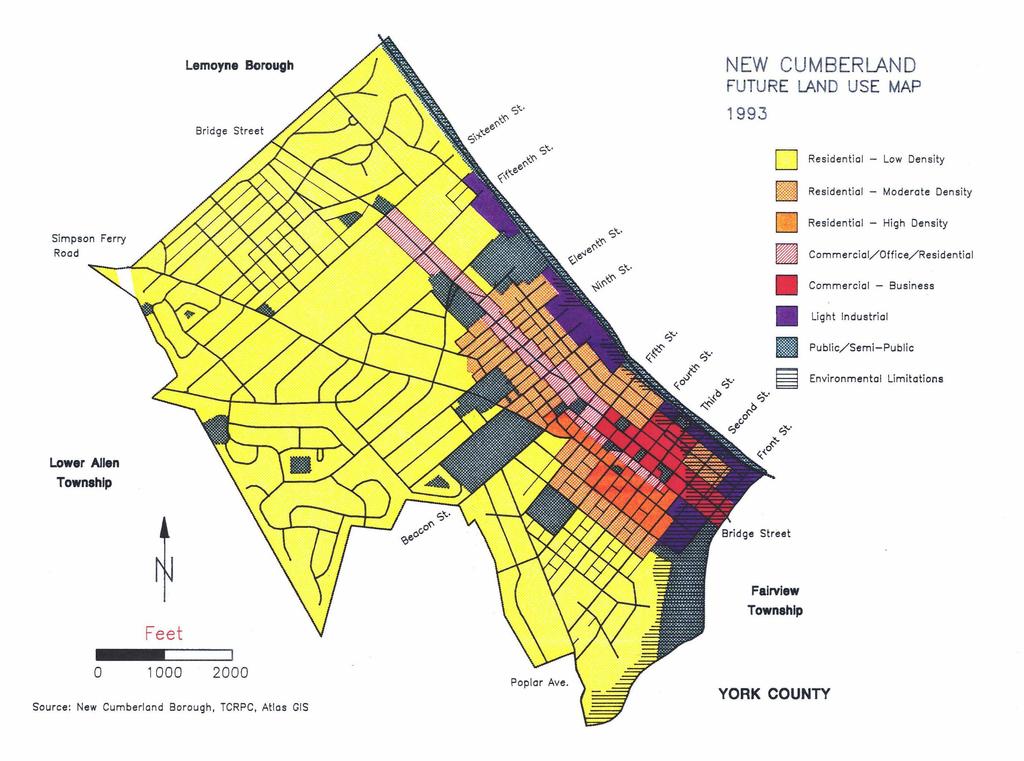
54
Existing Land Use. Typical densities for single-family detached residential development in Cumberland County: 1
 Existing Land Use A description of existing land use in Cumberland County is fundamental to understanding the character of the County and its development related issues. Economic factors, development trends,
Article 3. SUBURBAN (S-) NEIGHBORHOOD CONTEXT
 NEIGHBORHOOD CONTEXT") Article 3. SUBURBAN (S-) NEIGHBORHOOD CONTEXT this page left intentionally blank Contents ARTICLE 3. SUBURBAN (S-) NEIGHBORHOOD CONTEXT DIVISION 3.1 NEIGHBORHOOD CONTEXT DESCRIPTION...3.1-1 Section 3.1.1
Article 3. SUBURBAN (S-) NEIGHBORHOOD CONTEXT this page left intentionally blank Contents ARTICLE 3. SUBURBAN (S-) NEIGHBORHOOD CONTEXT DIVISION 3.1 NEIGHBORHOOD CONTEXT DESCRIPTION...3.1-1 Section 3.1.1
HOUSING ELEMENT Inventory Analysis
 HOUSING ELEMENT Inventory Analysis 2.100 INVENTORY Age of Housing Stock Table 2.25 shows when Plantation's housing stock was constructed. The latest available data with this kind of breakdown is 2010.
Chapter 1107: Zoning Districts
 Chapter 1107: Zoning Districts 1107.01 Establishment of Zoning Districts (a) Districts Established In order to carry out the purpose of this code, the City is hereby divided into the zoning districts established
DIVISION 1 PURPOSE OF DISTRICTS
 ARTICLE 2 ZONING DISTRICTS AND MAP DIVISION 1 PURPOSE OF DISTRICTS Section 2.101 Zoning Districts. For the purpose of this Ordinance, the City of Richmond is hereby divided into districts as follows: DISTRICT
Missing Middle Housing Types Showcasing examples in Springfield, Oregon
 Missing Middle Housing Types Showcasing examples in Springfield, Oregon MissingMiddleHousing.com is powered by Opticos Design Illustration 2015 Opticos Design, Inc. Missing Middle Housing Study Prepared
ARTICLE B ZONING DISTRICTS
 ARTICLE B ZONING DISTRICTS Sec. 8-3021 Established. In order to protect the character of existing neighborhoods; to prevent excessive density of population in areas which are not adequately served with
APPENDIX C CHARACTERISTICS OF THE ENERGIZE PHOENIX CORRIDOR
 APPENDIX C CHARACTERISTICS OF THE ENERGIZE PHOENIX CORRIDOR BACKGROUND ON RESIDENTIAL AND COMMERCIAL BUILDINGS IN THE EP CORRIDOR The 10-mile EP corridor (Figure G1) is a highly diverse, mixed-use L-shaped
Chapter 2: Existing Land Use
 Chapter 2: Existing Land Use Existing Land Use An inventory of existing land use describes existing patterns of development. The inventory provides useful information to calculate the ultimate population
8Land Use. The Land Use Plan consists of the following elements:
 8Land Use 1. Introduction The Land Use Plan consists of the following elements: 1. Introduction 2. Existing Conditions 3. Opportunities for Redevelopment 4. Land Use Projections 5. Future Land Use Policies
2.2.2 The Land Use Setting
 2-6 Planning Area pearance varies dramatically from season to season. The absence of significant topographic or man-made features within the District contributes to a very open visual character that allows
P o p u l a t i o n, L a n d U s e, a n d Z o n i n g
 P o p u l a t i o n, L a n d U s e, a n d Z o n i n g The Town of Upper Marlboro is located only 15 miles southeast of the District of Columbia, in the central portion of Prince George s County in the
2014 Plan of Conservation and Development
 The Town of Hebron Section 1 2014 Plan of Conservation and Development Community Profile Introduction (Final: 8/29/13) The Community Profile section of the Plan of Conservation and Development is intended
8.5.1 R1, Single Detached Residential District
 8.5.1 R1, Single Detached Residential District The purpose of this district is to provide for residential development in the form of single detached dwellings. Dwelling, Single Detached Home Business,
City of Exeter Housing Element
 D. Housing Stock Characteristics Government Code Section 65583(a) requires an analysis and documentation of household characteristics, including level of payment compared to ability to pay, housing characteristics,
CASTLES OF CALEDON URBAN DESIGN REPORT
 CASTLES OF CALEDON URBAN DESIGN REPORT PROPOSED RESIDENTIAL DEVELOPMENT CALEDON, ONTARIO 10 JULY, 2015 TABLE CONTENTS: 1.0 DEVELOPMENT 4.0 CONCLUSION 1.1 Introduction 1.2 Castles of Caledon- Urban Design
410 Land Use Trends Comprehensive Plan Section 410
 411 410 Comprehensive Plan Section 410 In order to plan future land use, we must know how the land is used today. This section includes the following: Definition of analyzed land-use categories Summary
Article Optional Method Requirements
 Article 59-6. Optional Method Requirements [DIV. 6.1. MPDU DEVELOPMENT IN RURAL RESIDENTIAL AND RESIDENTIAL ZONES Sec. 6.1.1. General Requirements... 6 2 Sec. 6.1.2. General Site and Building Type Mix...
RP-2, RP-3, RP-4, AND RP-5 PLANNED RESIDENTIAL DISTRICTS
 6.10 - RP-2, RP-3, RP-4, AND RP-5 PLANNED RESIDENTIAL DISTRICTS 6.10.1 GENERAL DESCRIPTION: 6.10.1.1 The regulations established in this Section are intended to provide optional methods of land development
Housing Study & Needs Assessment
 Housing Study & Needs Assessment Phase II Public Engagement Presentation #2 Winston-Salem, North Carolina January 25, 2018 MEETING OVERVIEW Welcome & Introductions Purpose & Goals Community Discussions
City of Grande Prairie Development Services Department
 City of Grande Prairie Development Services Department COUNTRYSIDE SOUTH OUTLINE PLAN Prepared by: GPEC Consulting Ltd. #202, 10712-100th Street Grande Prairie, AB Council Resolution of August 20, 2001
NORTHWEST QUADRANT NEIGHBORHOOD STUDY
 City of Novato General Plan 2035 Focus Area NORTHWEST QUADRANT NEIGHBORHOOD STUDY May, 2015 Why a Neighborhood Study? The Northwest Quadrant Neighborhood, north of the Grant Avenue business district,
CHAPTER 4: MODERATE INCOME HOUSING ELEMENT
 The Utah Municipal Code, -9a-()(a)(iii) requires that all cities adopt a Plan for Moderate Income Housing as part of their General Plan. Section -9a-() of the Utah Municipal Code, outlines that this Plan
CHAPTER 7 HOUSING. Housing May
 CHAPTER 7 HOUSING Housing has been identified as an important or very important topic to be discussed within the master plan by 74% of the survey respondents in Shelburne and 65% of the respondents in
Land Use. Land Use Categories. Chart 5.1. Nepeuskun Existing Land Use Inventory. Overview
 Land Use State Comprehensive Planning Requirements for this Chapter A compilation of objectives, policies, goals, maps and programs to guide the future development and redevelopment of public and private
ARTICLE 2 ZONING DISTRICTS AND MAPS
 ARTICLE 2 ZONING DISTRICTS AND MAPS SECTION 2.100 PURPOSE OF DISTRICTS Section 2.101. For the purpose of this Ordinance, Billings Township is hereby divided into districts as follows: DISTRICT NAME SYMBOL
Appendix A: Guide to Zoning Categories Prince George's County, Maryland
 Appendix A: Guide to Zoning Categories Prince George's County, Maryland RESIDENTIAL ZONES 1 Updated November 2010 R-O-S: Reserved Open Space - Provides for permanent maintenance of certain areas of land
this page left intentionally blank DENVER ZONING CODE
 Article 1. GENERAL PROVISIONS this page left intentionally blank Contents ARTICLE 1. GENERAL PROVISIONS DIVISION 1.1 GENERAL...1.1-1 Section 1.1.1 Purpose...1.1-1 Section 1.1.2 Intent...1.1-1 Section 1.1.3
3. FISCAL IMPACT ANALYSIS FISCAL IMPACT ANALYSIS 29
 3. FISCAL IMPACT ANALYSIS FISCAL IMPACT ANALYSIS 29 The purpose of fiscal impact analysis is to estimate the impact of a development or a land use change on the budgets of governmental units serving the
Table of Contents. Appendix...22
 Table Contents 1. Background 3 1.1 Purpose.3 1.2 Data Sources 3 1.3 Data Aggregation...4 1.4 Principles Methodology.. 5 2. Existing Population, Dwelling Units and Employment 6 2.1 Population.6 2.1.1 Distribution
Housing Element Amendment. Borough of High Bridge
 Housing Element Amendment Borough of High Bridge Hunterdon County New Jersey September, 2004 Prepared for: The Borough of High Bridge 71 Main Street High Bridge, N.J. 08829 Prepared by: Art Bernard, P.P.
Place Type Descriptions Vision 2037 Comprehensive Plan
 Place Type Descriptions Vision 2037 Comprehensive Plan The Vision 2037 Comprehensive Plan establishes a range of place types for Oxford, ranging from low intensity (limited development) Rural and Natural
4.0. Residential. 4.1 Context
 4. 0Residential 4.1 Context In 1986, around the time of Burnaby s last Official Community Plan, the City had a population of 145,000 living in 58,300 residential units. By 1996, there were 179,000 people
DEVELOPMENT DEPARTMENT STAFF REPORT STAFF REPORT DRESDEN DRIVE TOWNHOMES DCI
 DEVELOPMENT DEPARTMENT STAFF REPORT Meeting Date: September 13, 2018 Item #: PZ2018-319 STAFF REPORT DRESDEN DRIVE TOWNHOMES DCI Request: Project Name: Development of Community Compact (DCI) and six concurrent
CASS COUNTY MASTER PLAN July 1, Appendix C LAND USE
 Appendix C LAND USE Introduction Existing land use and development patterns in Cass County are important considerations in the development of policies addressing future growth and land use. Existing land
Document under Separate Cover Refer to LPS State of Housing
 Document under Separate Cover Refer to LPS5-17 216 State of Housing Contents Housing in Halton 1 Overview The Housing Continuum Halton s Housing Model 3 216 Income & Housing Costs 216 Indicator of Housing
GENERAL PLAN UPDATE SPECIFIC AREAS OF THE CITY
 GENERAL PLAN UPDATE SPECIFIC AREAS OF THE CITY Background There are a total of 14 specific areas that are being reviewed as part of the update of the General Plan. Requests to review these areas came from
Ch. 14 CAPITOL HILL. Historic Districts - Apartment and Multi-family Development
 Historic Districts - Apartment and Multi-family Development Ch. 14 CAPITOL HILL A HISTORY OF APARTMENT AND MULTI-FAMILY DEVELOPMENT The following background on the historical development of apartment and
San Diego County Vol. XX, Issue I Rental Trends Executive Summary March 2007
 Real Estate Research and Consulting for over 25 years Vol. XX, Issue I Rental Trends Executive Summary Editor: Robert D. Martinez- Director of Research s institutional grade rental complexes experienced
Public Review of the Slot Home Text Amendment
 Public Review of the Slot Home Text Amendment The proposed amendments to the Denver Zoning Code have been informed by the Slot Home Strategy Report. This document has been developed out of a robust process
City of Lonsdale Section Table of Contents
 City of Lonsdale City of Lonsdale Section Table of Contents Page Introduction Demographic Data Overview Population Estimates and Trends Population Projections Population by Age Household Estimates and
Table of Contents. Title Page # Title Page # List of Tables ii 6.7 Rental Market - Townhome and Apart ment Rents
 RESIDENTIAL MONITORING REPORT 2013 Table of Contents Title Page # Title Page # List of Tables ii 6.7 Rental Market - Townhome and Apart ment Rents 21 List of Figures iii 7.0 Other Housing Demands and Trends
City of Valdosta Land Development Regulations
 Chapter 206 Section 206-1 Base Zoning Districts Standards for Uses, Structures, and Property Development (B) (C) Principal Uses and Structures. Principal uses and structures permitted in each base zoning
ARTICLE 3: Zone Districts
 ARTICLE 3: Zone Districts... 3-1 17.3.1: General...3-1 17.3.1.1: Purpose and Intent... 3-1 17.3.2: Districts and Maps...3-1 17.3.2.1: Applicability... 3-1 17.3.2.2: Creation of Districts... 3-1 17.3.2.3:
COMMERCIAL ELEMENT AND CODE ENFORCEMENT
 COMMERCIAL ELEMENT AND CODE ENFORCEMENT The Commercial Element identifies and describes the existing characteristics that are desired by the neighborhood. The existing conditions will determine appropriate
Residential Design Guide Appendices
 Residential Design Guide Appendices Appendix 1 Thorndon Appendix 2 Mt Victoria Appendix 3 Aro Valley Appendix 4 Southern Inner Residential Areas Appendix 5 Oriental Bay Appendix 6 Residential Coastal Edge
Housing for the Region s Future
 Housing for the Region s Future Executive Summary North Texas is growing, by millions over the next 40 years. Where will they live? What will tomorrow s neighborhoods look like? How will they function
** If your lot does not meet the requirements above, please read Sec below
 Sec. 13-1-60 Zoning District Dimensional Requirements. For the Zoning Dept To Issue a Land Use Permit The Following Dimensions are Required. Minimum Side and Rear Yards s Lakes Classification Minimum Class
CHAPTER 3. HOUSING AND ECONOMIC DEVELOPMENT
 CHAPTER 3. HOUSING AND ECONOMIC DEVELOPMENT This chapter analyzes the housing and economic development trends within the community. Analysis of state equalized value trends is useful in estimating investment
MONROE WARD REZONING SUMMARY. October 2018
 MONROE WARD REZONING SUMMARY October 2018 WHY IS THE CITY REZONING MONROE WARD? In July of 2017 Richmond City Council adopted The Pulse Corridor Plan, a corridor-long planning document that outlines steps
2015 Downtown Parking Study
 2015 Downtown Parking Study City of Linden Genesee County, Michigan November 2015 Prepared by: City of Linden Downtown Development Authority 132 E. Broad Street Linden, MI 48451 www.lindenmi.us Table of
A. Land Use Relationships
 Chapter 9 Land Use Plan A. Land Use Relationships Development patterns in Colleyville have evolved from basic agricultural and residential land uses, predominate during the early stages of Colleyville
TOTTENHAM SECONDARY PLAN
 TOTTENHAM SECONDARY PLAN AMENDMENT NO. 11 TO THE OFFICIAL PLAN OF THE TOWN OF NEW TECUMSETH The following text and schedules to the Official Plan of the Town of New Tecumseth constitute Amendment No. 11
Midwest City, Oklahoma Zoning Ordinance
 2010 Midwest City, Oklahoma Zoning Ordinance 9/2/2010 Table of Contents Section 1. General Provisions... 5 1.1. Citation... 5 1.2. Authority... 5 1.3. Purpose... 5 1.4. Nature and Application... 5 1.5.
Generic Environmental Impact Statement. Build-Out Analysis. City of Buffalo, New York. Prepared by:
 Generic Environmental Impact Statement Build-Out Analysis City of Buffalo, New York 2015 Prepared by: TABLE OF CONTENTS 1.0 INTRODUCTION 1 2.0 METHODOLOGY 2 3.0 EXISTING LAND USE 3 4.0 EXISTING ZONING
THE REDEVELOPMENT PLAN
 PAGE 37 THE REDEVELOPMENT PLAN FUTURE LAND USE The Silver Terrace Redevelopment Area is currently designated as Redevelopment Area #4 on the City of Delray Beach Future Land Use Map (FLUM). This designation
3.1. OBJECTIVES FOR RESIDENTIAL LAND USE DESIGNATIONS GENERAL OBJECTIVES FOR ALL RESIDENTIAL DESIGNATIONS
 3. RESIDENTIAL LAND USE DESIGNATIONS INTRODUCTION The Residential land use designations provide for housing and other land uses that are integral to, and supportive of, a residential environment. Housing
Chapter 17-2 Residential Districts
 Chapter 17-2 Residential Districts 17-2-0100 District Descriptions...2-1 17-2-0200 Allowed Uses...2-2 17-2-0300 Bulk and Density Standards...2-5 17-2-0400 Character Standards...2-18 17-2-0500 Townhouse
Article 6. GENERAL URBAN (G-) NEIGHBORHOOD CONTEXT
 NEIGHBORHOOD CONTEXT") Article 6. GENERAL URBAN (G-) NEIGHBORHOOD CONTEXT this page left intentionally blank Contents ARTICLE 6. GENERAL URBAN (G-) NEIGHBORHOOD CONTEXT DIVISION 6.1 NEIGHBORHOOD CONTEXT DESCRIPTION...6.1-1 Section
Article 6. GENERAL URBAN (G-) NEIGHBORHOOD CONTEXT this page left intentionally blank Contents ARTICLE 6. GENERAL URBAN (G-) NEIGHBORHOOD CONTEXT DIVISION 6.1 NEIGHBORHOOD CONTEXT DESCRIPTION...6.1-1 Section
Comprehensive Plan /24/01
 IV The is a central component of the Comprehensive Plan. It is an extension of the general goals and policies of the community, as well as a reflection of previous development decisions and the physical
From Policy to Reality
 From Policy to Reality Updated ^ Model Ordinances for Sustainable Development 2000 Environmental Quality Board 2008 Minnesota Pollution Control Agency Funded by a Minnesota Pollution Control Agency Sustainable
SPECIAL ZONING DISTRICTS
 SPECIAL ZONING DISTRICTS 5.01 5.99 RESERVED 5.100 PLANNED DEVELOPMENTS: Purpose: This district is intended to accommodate unified design of residential, commercial, office, professional services, retail
Chapter 9 Multiple Choice Questions
 Chapter 9 Multiple Choice Questions / Page 1 Chapter 9 Multiple Choice Questions 1. The text argues that students of real estate should study factors that influence demand at the national, regional, community
Land Use Survey Summer 2014
 Land Use Survey Summer 2014 North Ogden City, Utah Robert Scott, City Planner Travis Lund, Planning Intern Contents General Information... 1 Land Use Groups... 1 Urbanized Land Uses... 1 Residential...
SJC Comprehensive Plan Update Housing Needs Assessment Briefing. County Council: October 16, 2017 Planning Commission: October 20, 2017
 SJC Comprehensive Plan Update 2036 Housing Needs Assessment Briefing County Council: October 16, 2017 Planning Commission: October 20, 2017 Overview GMA Housing Element Background Demographics Employment
CHAPTER 2: HOUSING. 2.1 Introduction. 2.2 Existing Housing Characteristics
 CHAPTER 2: HOUSING 2.1 Introduction Housing Characteristics are related to the social and economic conditions of a community s residents and are an important element of a comprehensive plan. Information
6. RESIDENTIAL ZONE REGULATIONS
 6. RESIDENTIAL ZONE REGULATIONS PART 6A PURPOSE OF CHAPTER (1) The purpose of this Chapter is to provide detailed regulations and requirements that are relevant only to residential zones and specific residential
Implementation. Approved Master Plan and SMA for Henson Creek-South Potomac 103
 Implementation Approved Master Plan and SMA for Henson Creek-South Potomac 103 104 Approved Master Plan and SMA for Henson Creek-South Potomac Sectional Map Amendment The land use recommendations in the
III - HOUSING. Q. 31 Plainfield should be kept residential. New businesses, other than home based or cottage businesses should be discouraged.
 III - HOUSING INTRODUCTION Housing is a basic component of a community's development process, influencing and influenced by the natural environment, regional development, public services, the community's
APPENDIX A. Market Study Standards and Requirements
 APPENDIX A Market Study Standards and Requirements Section 42(m)(1)(A)(iii) of the IRS Code and Section IV(A)(2) of the 2018 Qualified Allocation Plan (QAP) require market studies for all low-income housing
ZONING AMENDMENT & SUBDIVISION STAFF REPORT Date: November 3, 2016
 ZONING AMENDMENT & SUBDIVISION STAFF REPORT Date: November 3, 2016 APPLICANT NAME SUBDIVISION NAME David Shumer 5955 Airport Subdivision CITY COUNCIL DISTRICT District 6 5955 Airport Boulevard, 754 Linlen
45 & 77 Dunfield Avenue - Zoning Amendment Application - Preliminary Report
 STAFF REPORT ACTION REQUIRED 45 & 77 Dunfield Avenue - Zoning Amendment Application - Preliminary Report Date: January 22, 2014 To: From: Wards: Reference Number: Toronto and East York Community Council
RECOMMENDED ACTION: Council may vote to make specific changes to the draft. Staff will be available to help in guiding specific motions.
 CITY COUNCIL Agenda Item #16-164. Date: June 8, 2016 Consent Discussion _x_ SUBJECT: Presentation of Part 2 Unified Development Bylaws SUBMITTING DEPARTMENT: Planning RECOMMENDED ACTION: Council may vote
SECTION 7. RESIDENTIAL DISTRICTS
 SECTION 7. RESIDENTIAL DISTRICTS 7.1 RESIDENTIAL DISTRICTS PURPOSE 7.2 PERMITTED AND SPECIAL USES 7.3 YARD AND BULK REGULATIONS 7.4 GENERAL STANDARDS OF APPLICABILITY 7.5 FLOOR AREA RATIO MEASUREMENT AND
A project of Neighborhood Projects for Community Revitalization At the Center for Urban and Regional Affairs (CURA) University of Minnesota
 University of Minnesota") Affordable Housing Siting Opportunities in Minneapolis October 2008 Rachel C. Robinson, Author With assistance from Joel Larson A project of Neighborhood Projects for Community Revitalization At the Center
Affordable Housing Siting Opportunities in Minneapolis October 2008 Rachel C. Robinson, Author With assistance from Joel Larson A project of Neighborhood Projects for Community Revitalization At the Center
DEVELOPMENT STANDARDS FOR RESIDENTIAL PROJECTS RESIDENTIAL BUILDING TYPES: APPROPRIATE ZONES AND DENSITIES 2-1
 2 DEVELOPMENT STANDARDS FOR RESIDENTIAL PROJECTS RESIDENTIAL BUILDING TYPES: APPROPRIATE ZONES AND DENSITIES 2-1 This Chapter presents the development standards for residential projects. Section 2.1 discusses
Planning Department Oconee County, Georgia
 Planning Department Oconee County, Georgia STAFF REPORT REZONE CASE #: 6985 DATE: October 31, 2016 STAFF REPORT BY: Andrew C. Stern, Planner APPLICANT NAME: Williams & Associates, Land Planners PC PROPERTY
1267 King Street West Zoning Amendment Final Report
 . STAFF REPORT ACTION REQUIRED 1267 King Street West Zoning Amendment Final Report Date: January 28, 2015 To: From: Wards: Reference Number: Toronto and East York Community Council Director, Community
PLANNING COMMISSION WILLIAMSBURG, VIRGINIA WORK SESSION AGENDA Wednesday, May 23, 2012
 PLANNING COMMISSION WILLIAMSBURG, VIRGINIA WORK SESSION AGENDA Wednesday, May 23, 2012 The meeting will be called to order in the third floor Conference Room (Room 310), Williamsburg Municipal Building,
Salem HNA and EOA Advisory Committee Meeting #6
 Salem HNA and EOA Advisory Committee Meeting #6 Residential Land Policies Employment Land Policies Policy Discussions with the Committee Outcome of today s meeting Direction from this Committee on proposed
PLANNING COMMISSION STAFF REPORT
 PLANNING COMMISSION STAFF REPORT REZONING CASE: RZ-15-002 REPORT DATE: January 26, 2016 CASE NAME: Thursday Lunch Club Rezoning PLANNING COMMISSION DATE: February 17, 2016 ADDRESS OF REZONING PROPOSAL:
ARTICLE SCHEDULE OF REGULATIONS
 ARTICLE 21.00 SCHEDULE OF REGULATIONS FOOTNOTES TO ARTICLE 21.00 SCHEDULE OF REGULATIONS a. If one or both public sanitary sewers and/or public water supply are not available minimum lot size shall be
150 Eglinton Avenue East - Zoning Amendment Application - Preliminary Report
 STAFF REPORT ACTION REQUIRED 150 Eglinton Avenue East - Zoning Amendment Application - Preliminary Report Date: May 15, 2015 To: From: Wards: Reference Number: Toronto and East York Community Council Director,
40-58 Widmer Street - Zoning Amendment Application - Preliminary Report
 STAFF REPORT ACTION REQUIRED 40-58 Widmer Street - Zoning Amendment Application - Preliminary Report Date: April 19, 2013 To: From: Wards: Reference Number: Toronto and East York Community Council Director,
2014 Plan of Conservation and Development. Development Plan & Policies
 The Town of Hebron Section 3 2014 Plan of Conservation and Development Development Plan & Policies C. Residential Districts I. Residential Land Analysis This section of the plan uses the land use and vacant
Town of Washington, New Hampshire Master Plan 2015
 OVERVIEW OF CURRENT SITUATION: Currently the town consists of one zoning district. The Land Use Ordinance allows a single family or duplex home on a four- acre lot or on a previously approved non- conforming
HOUSING ISSUES REPORT
 HOUSING ISSUES REPORT 8, 12 & 14 HIGH PARK AVENUE AND 1908, 1910, 1914 & 1920 BLOOR STREET WEST CITY OF TORONTO PREPARED FOR: 619595 ONTARI O INC. February 2016 TABLE OF CONTENTS 1.0 INTRODUCTION 1 2.0
Introduction. Charlotte Fagan, Skyler Larrimore, and Niko Martell
 Charlotte Fagan, Skyler Larrimore, and Niko Martell Introduction Powderhorn Park Neighborhood, located in central-southern Minneapolis, is one of the most economically and racially diverse neighborhoods
DEVELOPMENT DEPARTMENT STAFF REPORT STAFF REPORT VARIANCE AND WAIVER THE ROSALYNN APARTMENTS
 DEVELOPMENT DEPARTMENT STAFF REPORT Meeting Date: September 14, 2017 Item #: _PZ-2017-153_ STAFF REPORT VARIANCE AND WAIVER THE ROSALYNN APARTMENTS Request: Variance and Waiver Project Name: The Rosalynn
Urban Mixed Use (UMU) Zoning District
 Zoning District") Urban Mixed Use (UMU) Zoning District Prepared by the City of Titusville Community Development Department Contents Purpose... 3 Background... 3 History of the Urban Mixed Use Zoning Classification... 4
Urban Mixed Use (UMU) Zoning District Prepared by the City of Titusville Community Development Department Contents Purpose... 3 Background... 3 History of the Urban Mixed Use Zoning Classification... 4
L. LAND USE. Page L-1
 L. LAND USE 1. Purpose This section discusses current and likely future land use patterns in Orland. An understanding of land use trends is very important in determining Orland's ability to absorb future
DEVELOPMENT DEPARTMENT STAFF REPORT THE PARK AT 5 TH
 DEVELOPMENT DEPARTMENT STAFF REPORT ARB Meeting Date: July 3, 2018 Item #: _PZ2018-293_ THE PARK AT 5 TH Request: Site Address: Project Name: Parcel Number: Applicant: Proposed Development: Current Zoning:
This is a conditional use permit request to establish a commercial wind energy conversion system.
 Public Works 600 Scott Boulevard South Hutchinson, Kansas 67505 620-694-2976 Road & Bridge Planning & Zoning Noxious Weed Utilities Date: March 28, 2019 To: From: Reno County Planning Commission Russ Ewy,
Land Use Development: Proper Planning Creates Smart Growth, Prevents Sprawl
 Pace University DigitalCommons@Pace Pace Law Faculty Publications School of Law 10-20-1999 Land Use Development: Proper Planning Creates Smart Growth, Prevents Sprawl John R. Nolon Elisabeth Haub School
City of Lafayette Staff Report Design Review Commission
 City of Lafayette Staff Report Design Review Commission Meeting Date: January 8, 2018 Staff: Subject: Sarah Allen, Senior Planner SS14-17 Dexter & Patricia Louie, (MRA Zoning) Request for a Study Session
CITY PLANNING COMMISSION CITY OF NEW ORLEANS EXECUTIVE DIRECTOR. City Planning Commission Staff Report. Executive Summary
 CITY PLANNING COMMISSION CITY OF NEW ORLEANS MITCHELL J. LANDRIEU MAYOR ROBERT D. RIVERS EXECUTIVE DIRECTOR LESLIE T. ALLEY DEPUTY DIRECTOR City Planning Commission Staff Report Zoning Docket 092/16 Executive
Official Plan & Zoning By-law Amendment Application Preliminary Report
 STAFF REPORT ACTION REQUIRED 847 873 Sheppard Avenue West Official Plan & Zoning By-law Amendment Application Preliminary Report Date: January 13, 2010 To: From: Wards: Reference Number: North York Community
DIVISION 7. R-6 AND R-6A RESIDENTIAL ZONES* The purpose of the R-6 residential zone is:
 Date of Draft: March 6, 2015 DIVISION 7. R-6 AND R-6A RESIDENTIAL ZONES* Sec. 14-135. Purpose. The purpose of the R-6 residential zone is: (a) To set aside areas on the peninsula for housing characterized
MARKHAM. Comprehensive Zoning By-law Project. Markham Zoning By-law Consultant Team
 City of MARKHAM Task 4B: Review & Assessment of Minor Variances Comprehensive Zoning By-law Project Markham Zoning By-law Consultant Team Gladki Planning Associates, R. E. Millward and Associates, Woodfield
Koochiching County Summary. January 2019
 Koochiching County Summary January 2019 Koochiching County Summary Introduction The Koochiching County Comprehensive Study was conducted in 2018. The study can be utilized by housing and economic development