CITY PLANNING COMMISSION CITY OF NEW ORLEANS EXECUTIVE DIRECTOR. City Planning Commission Staff Report. Executive Summary
|
|
|
- Jayson Boyd
- 5 years ago
- Views:
Transcription
1 CITY PLANNING COMMISSION CITY OF NEW ORLEANS MITCHELL J. LANDRIEU MAYOR ROBERT D. RIVERS EXECUTIVE DIRECTOR LESLIE T. ALLEY DEPUTY DIRECTOR City Planning Commission Staff Report Zoning Docket 092/16 Executive Summary Applicant: Request: Location: Jerome and Wanda J. Williams This is a request for a zoning change from an S-B1 Suburban Business District to an S-B2 Suburban Pedestrian-Oriented Corridor Business District. The municipal address is Morrison Road. Summary of Proposal: Master Plan: Recommendation: Zoning Docket 092/16 is a request for a zoning change from an S-B1 Suburban Commercial District to an S-B2 Suburban Pedestrian-Oriented Corridor Business District. The applicant proposes a zoning change in order to subdivide the parcel into an adjacent parcel on Morrison Road for a proposed O Reilly Auto Parts retail store development. Given its size, this retail store is a conditional use in the existing S-B1 Suburban Business District but would be allowed as a permitted use in the proposed S-B2 Suburban Pedestrian-Oriented Corridor Business District. The property has a history of vacancy and underutilization and is adjacent to another vacant parcel. The proposal is consistent with the Master Plan. The proposal is consistent with the Master Plan. The staff recommends APPROVAL of the request. Reasons for Recommendation: 1. The request is consistent with the Plan for the 21 st Century: New Orleans 2030 ZD 092/16 1
2 2. The site and the adjacent lot are intended to serve as a single development site. The zoning change would ensure consistent zoning across the entire development site. ZD 092/16 2
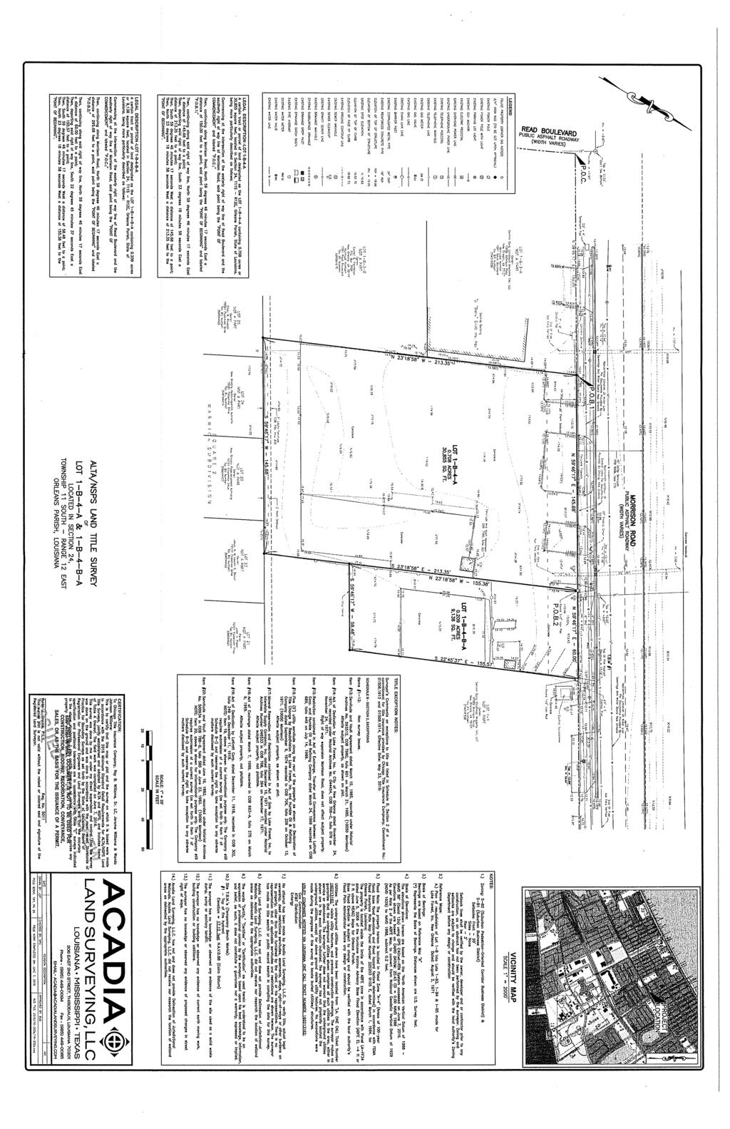
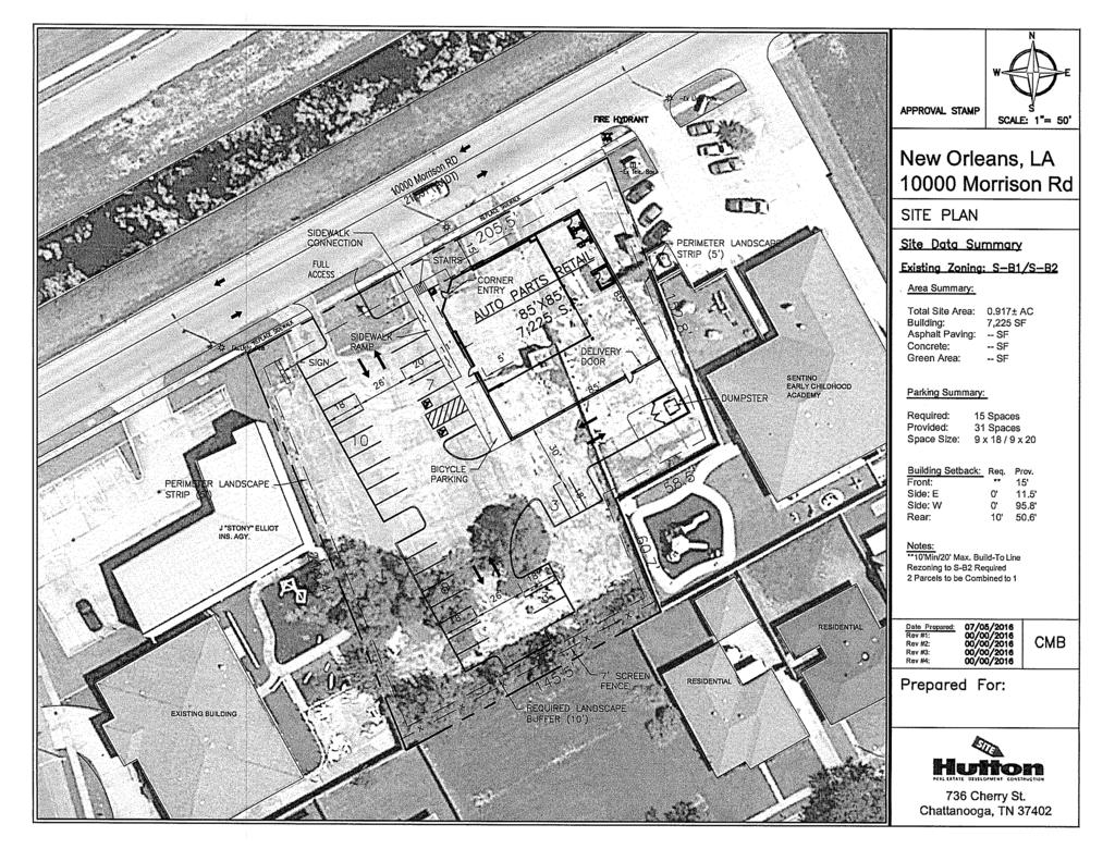
3 City Planning Commission Meeting CPC Deadline: 11/12/16 Tuesday, September 13, 2016 CC Deadline: 60 days from receipt Council District: E Council Member: Gray PRELIMINARY STAFF REPORT Zoning Docket: 092/16 To: City Planning Commission From: Robert Rivers, Executive Director Stephen Kroll, Planning Administrator Prepared by: Stosh Kozlowski Date: September 6, 2016 I. GENERAL INFORMATION: Applicant: Request: Location: Description: Jerome and Wanda J. Williams This is a request for a zoning change from an S-B1 Suburban Business District to an S-B2 Suburban Pedestrian-Oriented Corridor Business District. The property is located on Section 24, Lot 1B4BA in the Third Municipal District, bounded by Read Boulevard, Morrison Road, Restgate Road and Flossmoor Drive. The municipal address is Morrison Road. (PD9) The petitioned site is located near the corner of Morrison Road and Read Boulevard. The site consists of a vacant lot measuring in total one hundred and forty-five feet (145 ) in width and two hundred and thirteen feet (213 ) in depth with a total of 30,885 square feet in area. The applicant proposes a zoning change in order to develop the site and the adjacent parcel at Morrison Road with an O Reilly Auto Parts retail store development. The 7,225 square foot retail store is allowed only as a conditional use in under the existing S-B1 District zoning, which allows retail stores up to 5,000 square feet by right and over 5,000 square feet as conditional uses. It would be allowed by right under the proposed S-B2 Suburban Pedestrian-Oriented Corridor Business District, which allows uses up to 25,000 square feet by right. The existing S-B1 District ZD 092/16 3

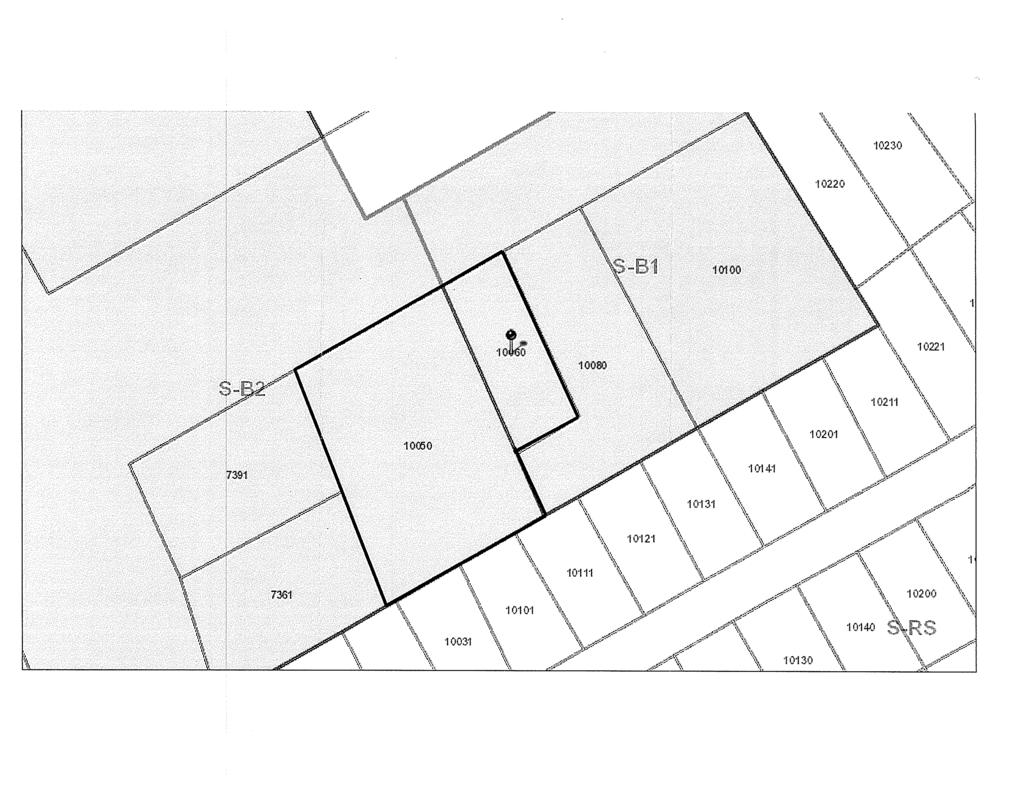
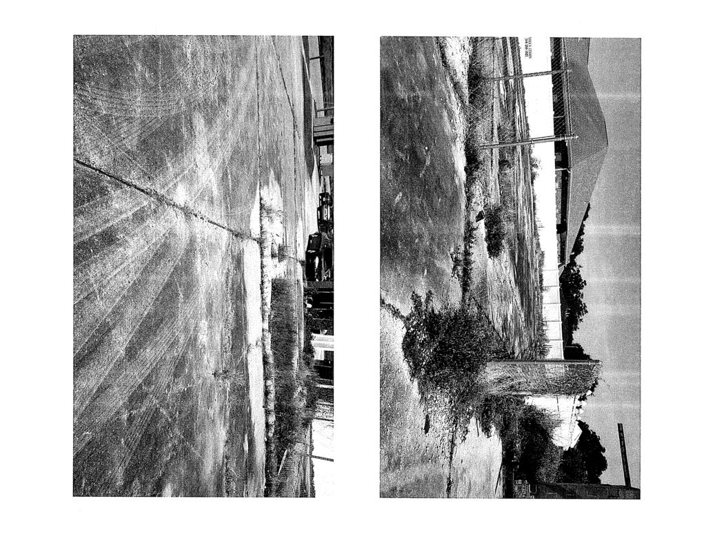
4 would limit the retail use to 5,000 square feet by right. The zoning change would also cause the zoning of the entire proposed O Reilly site to be consistent. The O Reilly site includes both the subject site and the adjacent lot at Morrison Road. The adjacent lot is currently zoned S-B2. Changing the subject site s zoning to also be S-B2 would cause the zoning of the entire O Reilly site to be uniform. Subject site (10060 Morrison Rd.) It is currently zoned S- B1 and proposed to be rezoned to S-B2. Adjacent site (10050 Morrison Rd.) It is zoned S-B2 and is to be combined with the subject site for development. Image 1: Arial view of and Morrison Road. Why is City Planning Commission action required? The City Planning Commission is required to make a recommendation on all requests for zoning map amendments prior to City Council action, in accordance with Article 4, Section 4.2.D.3 Actions by the City Planning Commission of the Comprehensive Zoning Ordinance. ZD 092/16 4

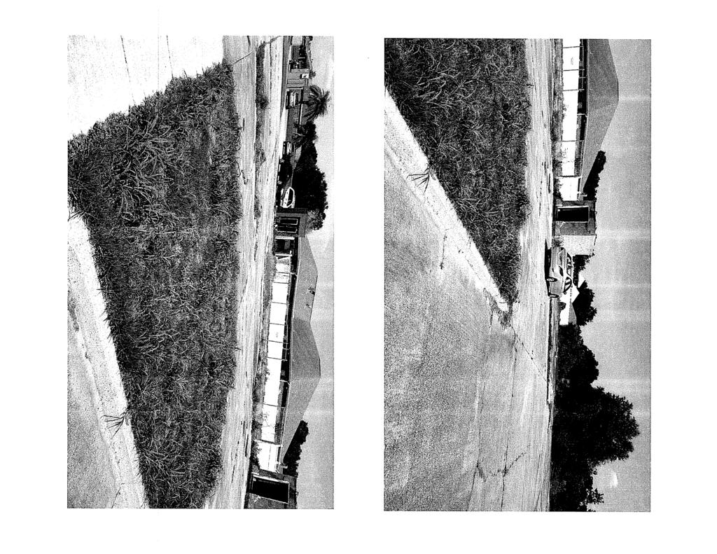
5 II. ANALYSIS A. What is the zoning of the surrounding areas? What is the existing land use and how are the surrounding areas used? Zoning The site is located within an exceptionally small S-B1 Suburban Business District which occupies only three lots, including the subject site. A small S-B2 Suburban Pedestrian-Oriented Corridor Business District is directly adjacent from the proposed site, covering just seven lots itself and bounded by a significantly large S-RS Suburban Single-Family Residential District. Located south of the subject property are a significant number of commercially zoned parcels that are adjacent to Interstate 10. Land use Image 2: Morrison Road Zoning The S-B1 Suburban Business District in which the site is located is composed of vacant land and an early child development center. The parcels abutting the S-B1 Suburban Business District are single-family dwellings to the east and an underutilized building hosting an insurance agency to the west. Across from the subject property is a wide canal and a Walgreens in the distance. Across Read Boulevard in the S-B2 District is a large Shell gas station, and a strip mall with various restaurant and retail uses including a seafood restaurant and a hair salon. The residences in the immediate neighborhood all maintain off-street parking. B. What is the zoning and land use history of the site? Zoning and Land Use History: Zoning: 1929 Unrestricted 1953 Single-Family District 1970 B2 Neighborhood Business District Prior to August 2015 B-2 Neighborhood Business District ZD 092/16 5
6 Land Use: 1929 Vacant Property 1949 Vacant Land 1999 Neighborhood Commercial 1 C. Have there been any recent zoning changes or conditional uses in the area? If so, do these changes indicate any particular pattern or trend? There have been no rezoning requests in the surrounding five block area within the last five years that the staff considers to be directly relevant to the application. D. Are any major streets involved? What impact will the proposed zoning change have on the transportation system, if any? Traffic The site is bounded by two-way, divided arterial with on-street parking available on Read Boulevard and a two-way collector street with on street parking available on Morrison Road. Flossmoor Drive and Restgate Road are both two-way local street with on-street parking availability. The proposed S-B2 District allows larger retail uses by right so there is a possibility that the zoning change could increase traffic. However, Read Boulevard and Morrison Road are operating under capacity and any increase in traffic could easily be managed by the existing roadway configuration. Off-street Parking The applicant will be required to provide off-street parking in accordance with Article 22. According Article 22, Section 22.4.A (Table 22-1) Off-Street Vehicle and Bicycle Parking Requirements. However, no off-street parking is required for a zoning change. E. What is the purpose of the proposed rezoning? The purpose of the zoning change is to allow the entire proposed O Reilly Auto Parts development site to have a consistent zoning that allows the development by right. The requested S-B2 District is intended to provide for relatively larger commercial developments that are consistent with the character of the surrounding neighborhood and are intended to serve the immediate area with minimal impact on the surrounding residential uses. It is intended for clusters of pedestrian-oriented business uses generally located along corridors. The district regulations are designed to encourage compatibility with adjacent or nearby suburban residential uses and maintain the pedestrian-oriented character of the area. 1 The 1999 Land Use Plan presented a generalized indication of land uses, and was not lot-specific. ZD 092/16 6
7 The uses allowed in the S-B2 District are generally the same as those allowed in the S-B1 District, with the exception it also allows permanent supportive housing facilities, bars, and kennels (all of which are conditional in the S-B2 District and prohibited in the S-B1 District) and funeral homes and public markets (which are permitted in S-B2 District and prohibited in the S-B1 District).. F. Can the request be considered a spot zone? Does it fall within the Historic Non- Conforming Use Policy? The request is not a spot zone. Spot zoning refers to zoning changes that have the effect of singling out a lot or other relatively small tracts of land for undue treatment different from similar surrounding parcels. These zoning changes have the effect of granting preferential treatment to these parcels which is not also granted to surrounding similar properties. The requested zoning change would expand the existing S-B2 District to an adjacent parcel, it would not be considered a spot zone because it simply shifts the boundary line from the existing S-B2 Distract. Because the property is not considered a spot zone, the subject site does not will not necessitate the review standards of the Historic Non-Conforming Use Policy. G. Evaluation of approval standards The City Planning Commission recommendation and the City Council decision on any zoning map amendment are matters of legislative discretion. In making their recommendation and decision, the City Planning Commission and the City Council are required to consider the standards in Table 4-1: Standards for Zoning Amendments of the Comprehensive Zoning Ordinance. In this section, the staff evaluates the application using those standards. The proposed amendment is compatible with the Master Plan and Future Land Use Map. This standard is met. The Master Plan s Future Land Use Map designates the site as within a Neighborhood Commercial area which includes both the S-B1 District and the S-B2 District at the intersection of Morrison Road. NEIGHBORHOOD COMMERCIAL Goal: Provide areas for small-scale, neighborhood-oriented commercial development that enhances the pedestrian character and convenience of neighborhoods by allowing commercial establishments in select locations within walking distance to surrounding residential areas. ZD 092/16 7
8 Range of Uses: Retail and professional service establishments serving local neighborhood area residents. Common uses include small groceries, restaurants, barber shops/salons, clothing boutiques, banks, pharmacies, and small health professional offices. Conversion to multifamily may be allowed for certain existing historic institutional, commercial or other non-residential buildings. Development Character: Buildings are oriented to the sidewalk (parking in rear where possible) with maximum heights related to the character of the street. Landscape requirements for parking lots facing the street. The proposed rezoning is consistent with the goal, range of uses or development character of the neighborhood commercial category. The requested S-B2 Suburban Pedestrian-Oriented Corridor Business District is intended to provide for commercial retail developments that are consistent with the character of the surrounding neighborhood and are intended to serve the immediate area with minimal impact on the surrounding residential uses. The S-B2 District is deemed consistent with the Neighborhood Commercial future land use designation by the Appendix A (commonly known as the consistency table ) of the Comprehensive Zoning Ordinance. The proposed amendment is compatible with the place designations of this Ordinance. This standard is met. Suburban neighborhoods are the neighborhoods that developed predominantly in the mid to late 20 th century, which are characterized by a lower density and a vehicle scale environment. The proposed amendment requests an S-B2 Suburban Pedestrian Oriented Corridor Business District, which is compatible with the place designation of the area. The proposed amendment is compatible with existing use and zoning of nearby property. This standard is met. The existing land use pattern in the immediate area is a mix of moderately-sized retail and service commercial uses (as well as vacant lots)around the intersection of Morrison Road and Read Boulevard surrounded by low-density, suburban single-family residential development. The proposed zoning change, which would simply shift the boundary between an S-B1 District and an S-B2 District to make the zoning consistent across a development parcel, is consistent with this land use and zoning pattern. ZD 092/16 8
9 The proposed amendment promotes the public health, safety and welfare of the City. This standard is met. The proposed zoning change is consistent with the Master Plan and would not impair the public health, safety, and welfare of the City. The proposed amendment is a more suitable zoning classification for the property than the current classification. This standard is sufficiently met. The proposed zoning is more suitable than the existing zoning because most of the O Reilly development site is zoned S-B2. Given the practical need to have a uniform zoning across the entire site, it makes more sense for the subject site, which constitutes only about a quarter of the overall development site, to be zoned S-B2. Given this and given that both the existing and proposed zoning districts are consistent with the Master Plan, the staff considers the proposed zoning classification to be more suitable than the existing zoning classification. Based upon the length of time that the property in question has been vacant, the proposed amendment is a more suitable zoning classification for the property than the current classification considered in the context of development in the area where the property is located. This standard is sufficiently met. The subject site is vacant and appears to have been vacant for some time. The site s zoning may contribute to this, although it has been zoned S-B2 only since August, The site s vacant state is more likely the result of larger economic conditions than it is of the site s zoning. Nevertheless, given that the proposed zoning is requested to allow the site s redevelopment, the request indicates that the current zoning may be discouraging development to some extent. The proposed amendment corrects an error or omission, adds clarification to existing requirements, or reflects a change in policy. The proposed amendment does not correct an error, or reflect a change in current policy. The proposed amendment benefits the citizens of the City as a whole. The proposed amendment requested in conjunction with a redevelopment proposal that would serve the surrounding neighborhood. However, the application would have minimal direct effect on the City as a whole. The proposed amendment provides a more workable way to achieve the intent and purposes of this Ordinance and the Master Plan. ZD 092/16 9
10 This standard is sufficiently met. The proposed amendment would be consistent with the intent of this Ordinance and the Master Plan, as the site would remain consistent with the Neighborhood Commercial future land use. The proposed amendment does not create a significant number of nonconformities. This standard is met. The proposed amendment for a zoning change would not create any nonconformities. The proposed amendment is compatible with the trend of development, if any, in the general area of the property in question. This standard is met. Across from Read Boulevard from the subject site, in the S-B2 District, is a large Shell gas station, and a strip mall with various restaurant and retail uses including a seafood restaurant and a hair salon. The proposed zoning change amendment would be allow for similar types of neighborhood-oriented commercial development, although potentially at a larger scale. IV. SUMMARY Zoning Docket 092/16 is a request for a zoning change from an S-B1 Suburban Commercial District to an S-B2 Suburban Pedestrian-Oriented Corridor Business District. The applicant proposes a zoning change in order to combine the parcel with an adjacent parcel on Morrison Road development with an O Reilly s Auto Parts retail store development. The use would be allowed under the proposed S-B2 Suburban Pedestrian- Oriented Corridor Business District. The zoning change would cause the entire development site to have consistent zoning. It sufficiently meets the approval standards for zoning change applications, including consistency with the Master Plan. V. PRELIMINARY STAFF RECOMMENDATION 2 The staff recommends APPROVAL of Zoning Docket 092/15, a request for a zoning change from an S-B1 Suburban Business District to an S-B2 Pedestrian Oriented Corridor Business District. VI. REASONS FOR RECOMMENDATION 1. The request is consistent with the Plan for the 21 st Century: New Orleans The site and the adjacent lot are intended to serve as a single development site. The zoning change would ensure consistent zoning across the entire development site. 2 Subject to modification by the City Planning Commission ZD 092/16 10

11 ZD 092/16 11

12 ZD 092/16 12
13
14
15
16
17
18
19
20
21
22
23
24
25
CITY PLANNING COMMISSION CITY OF NEW ORLEANS EXECUTIVE DIRECTOR. City Planning Commission Staff Report. Executive Summary
 CITY PLANNING COMMISSION CITY OF NEW ORLEANS MITCHELL J. LANDRIEU MAYOR ROBERT D. RIVERS EXECUTIVE DIRECTOR LESLIE T. ALLEY City Planning Commission Staff Report Executive Summary Zoning Docket 053/16
CITY PLANNING COMMISSION CITY OF NEW ORLEANS EXECUTIVE DIRECTOR. City Planning Commission Staff Report Executive Summary
 CITY PLANNING COMMISSION CITY OF NEW ORLEANS MITCHELL J. LANDRIEU MAYOR ROBERT D. RIVERS EXECUTIVE DIRECTOR LESLIE T. ALLEY DEPUTY DIRECTOR City Planning Commission Staff Report Executive Summary Zoning
CITY PLANNING COMMISSION CITY OF NEW ORLEANS EXECUTIVE DIRECTOR. City Planning Commission Staff Report. Executive Summary
 CITY PLANNING COMMISSION CITY OF NEW ORLEANS MITCHELL J. LANDRIEU MAYOR ROBERT D. RIVERS EXECUTIVE DIRECTOR LESLIE T. ALLEY DEPUTY DIRECTOR City Planning Commission Staff Report Zoning Docket 095/16 Executive
CITY PLANNING COMMISSION CITY OF NEW ORLEANS MITCHELL J. LANDRIEU ROBERT D. RIVERS EXECUTIVE DIRECTOR. City Planning Commission Staff Report
 CITY PLANNING COMMISSION CITY OF NEW ORLEANS MITCHELL J. LANDRIEU ROBERT D. RIVERS MAYOR EXECUTIVE DIRECTOR City Planning Commission Staff Report LESLIE T. ALLEY DEPUTY DIRECTOR Zoning Docket: 108/16 Executive
CITY PLANNING COMMISSION CITY OF NEW ORLEANS EXECUTIVE DIRECTOR. City Planning Commission Staff Report. Executive Summary
 CITY PLANNING COMMISSION CITY OF NEW ORLEANS MITCHELL J. LANDRIEU MAYOR ROBERT D. RIVERS EXECUTIVE DIRECTOR LESLIE T. ALLEY DEPUTY DIRECTOR City Planning Commission Staff Report Zoning Docket: 032/18 Executive
CITY PLANNING COMMISSION CITY OF NEW ORLEANS EXECUTIVE DIRECTOR. City Planning Commission Staff Report. Executive Summary
 CITY PLANNING COMMISSION CITY OF NEW ORLEANS MITCHELL J. LANDRIEU MAYOR ROBERT D. RIVERS EXECUTIVE DIRECTOR LESLIE T. ALLEY DEPUTY DIRECTOR City Planning Commission Staff Report Zoning Docket: 050/16 Executive
ZD Page 1 of 16 CITY PLANNING COMMISSION CITY OF NEW ORLEANS EXECUTIVE DIRECTOR. City Planning Commission Staff Report.
 ZD049-16 Page 1 of 16 CITY PLANNING COMMISSION CITY OF NEW ORLEANS MITCHELL J. LANDRIEU MAYOR ROBERT D. RIVERS EXECUTIVE DIRECTOR LESLIE T. ALLEY DEPUTY DIRECTOR City Planning Commission Staff Report Executive
CITY PLANNING COMMISSION CITY OF NEW ORLEANS EXECUTIVE DIRECTOR. City Planning Commission Staff Report. Executive Summary
 CITY PLANNING COMMISSION CITY OF NEW ORLEANS MITCHELL J. LANDRIEU MAYOR ROBERT D. RIVERS EXECUTIVE DIRECTOR LESLIE T. ALLEY DEPUTY DIRECTOR City Planning Commission Staff Report Zoning Docket 059/16 Executive
CITY PLANNING COMMISSION CITY OF NEW ORLEANS EXECUTIVE DIRECTOR. City Planning Commission Staff Report. Executive Summary
 CITY PLANNING COMMISSION CITY OF NEW ORLEANS MITCHELL J. LANDRIEU MAYOR ROBERT D. RIVERS EXECUTIVE DIRECTOR LESLIE T. ALLEY DEPUTY DIRECTOR City Planning Commission Staff Report Zoning Docket 096/16 Executive
CITY PLANNING COMMISSION CITY OF NEW ORLEANS EXECUTIVE DIRECTOR. City Planning Commission Staff Report. Executive Summary
 CITY PLANNING COMMISSION CITY OF NEW ORLEANS MITCHELL J. LANDRIEU MAYOR ROBERT D. RIVERS EXECUTIVE DIRECTOR LESLIE T. ALLEY DEPUTY DIRECTOR City Planning Commission Staff Report Executive Summary Zoning
CITY PLANNING COMMISSION
 CITY PLANNING COMMISSION TO: HONORABLE CITY COUNCIL FROM: CITY PLANNING COMMISSION DATE: AUGUST 3, 2017 SUBJECT: REPORT AND RECOMMENDATION OF THE CITY PLANNING COMMISSION Ladies and Gentlemen: Attached
ARTICLE 3: Zone Districts
 ARTICLE 3: Zone Districts... 3-1 17.3.1: General...3-1 17.3.1.1: Purpose and Intent... 3-1 17.3.2: Districts and Maps...3-1 17.3.2.1: Applicability... 3-1 17.3.2.2: Creation of Districts... 3-1 17.3.2.3:
CITY PLANNING COMMISSION CITY OF NEW ORLEANS EXECUTIVE DIRECTOR. City Planning Commission Staff Report Executive Summary
 CITY PLANNING COMMISSION CITY OF NEW ORLEANS MITCHELL J. LANDRIEU MAYOR ROBERT D. RIVERS EXECUTIVE DIRECTOR LESLIE T. ALLEY DEPUTY DIRECTOR City Planning Commission Staff Report Executive Summary Zoning
CITY PLANNING COMMISSION CITY OF NEW ORLEANS EXECUTIVE DIRECTOR. City Planning Commission Staff Report. Executive Summary
 CITY PLANNING COMMISSION CITY OF NEW ORLEANS MITCHELL J. LANDRIEU MAYOR ROBERT D. RIVERS EXECUTIVE DIRECTOR Subdivision Docket 105-16 City Planning Commission Staff Report Executive Summary LESLIE T. ALLEY
CITY PLANNING COMMISSION CITY OF NEW ORLEANS EXECUTIVE DIRECTOR. City Planning Commission Staff Report. Executive Summary
 CITY PLANNING COMMISSION CITY OF NEW ORLEANS MITCHELL J. LANDRIEU MAYOR ROBERT D. RIVERS EXECUTIVE DIRECTOR LESLIE T. ALLEY DEPUTY DIRECTOR City Planning Commission Staff Report Executive Summary Zoning
REZONING GUIDE. Zone Map Amendment (Rezoning) - Application. Rezoning Application Page 1 of 3. Return completed form to
 - Application. Rezoning Application Page 1 of 3. Return completed form to") COMMUNITY PLANNING & DEVELOPMENT REZONING GUIDE Rezoning Application Page 1 of 3 Zone Map Amendment (Rezoning) - Application PROPERTY OWNER INFORMATION* PROPERTY OWNER(S) REPRESENTATIVE** CHECK IF POINT
COMMUNITY PLANNING & DEVELOPMENT REZONING GUIDE Rezoning Application Page 1 of 3 Zone Map Amendment (Rezoning) - Application PROPERTY OWNER INFORMATION* PROPERTY OWNER(S) REPRESENTATIVE** CHECK IF POINT
PLANNING COMMISSION STAFF REPORT
 PLANNING COMMISSION STAFF REPORT MEETING DATE: 16 May 2013 APPLICANT: V&K Investments, LLC REQUEST: Zoning Map Amendment for 3232 South 300 East ZONE: Single-Family Residential to Commercial Corridor PREPARED
VILLAGE OF DOWNERS GROVE PLAN COMMISSION VILLAGE HALL COUNCIL CHAMBERS 801 BURLINGTON AVENUE. June 2, :00 p.m. AGENDA
 VILLAGE OF DOWNERS GROVE PLAN COMMISSION VILLAGE HALL COUNCIL CHAMBERS 801 BURLINGTON AVENUE June 2, 2014 7:00 p.m. AGENDA 1. Call to Order 2. Roll Call a. Pledge of Allegiance 3. Approval of Minutes April
ARTICLE 3 ZONING DISTRICTS AND ZONING MAP. Table of Contents
 ARTICLE 3 ZONING DISTRICTS AND ZONING MAP Table of Contents 3-1 Establishment of Zoning Districts... 1 A. General Use Zoning Districts... 1 B. Conditional Zoning Districts... 3 C. Overlay Zoning Districts...
City of Valdosta Land Development Regulations
 Chapter 206 Section 206-1 Base Zoning Districts Standards for Uses, Structures, and Property Development (B) (C) Principal Uses and Structures. Principal uses and structures permitted in each base zoning
Glades County Staff Report and Recommendation REZONING
 Glades County Staff Report and Recommendation REZONING CASE NUMBER: RZ15-01 DATE: October 2, 2015 CASE TYPE: Application for Rezoning REQUEST: J.J. Wiggins Memorial Trust is requesting a rezoning of 22.1±
Tuss and Lisa Taylor. Agriculture
 ZONE CHANGE STAFF REPORT CCPC City-County Planning Commission warrenpc.org (270) 842-1953 1141 State Street Bowling Green, KY 42101 DOCKET/CASE/APPLICATION NUMBER 2018-29-Z-CO PUBLIC HEARING DATE July
Midwest City, Oklahoma Zoning Ordinance
 2010 Midwest City, Oklahoma Zoning Ordinance 9/2/2010 Table of Contents Section 1. General Provisions... 5 1.1. Citation... 5 1.2. Authority... 5 1.3. Purpose... 5 1.4. Nature and Application... 5 1.5.
M E M O R A N D U M. Meeting Date: April 9, Item No. F-1. Planning and Zoning Commission. Scott Bradburn, Planner I
 M E M O R A N D U M Meeting Date: April 9, 2018 Item No. F-1 To: From: Subject: Planning and Zoning Commission Scott Bradburn, Planner I PUBLIC HEARING: Consider a recommendation for a Specific Use Permit
FREQUENTLY USED PLANNING & ZONING TERMS
 City Of Mustang FREQUENTLY USED PLANNING & ZONING TERMS Abut: Having property lines, street lines, or zoning district lines in common. Accessory Structure: A structure of secondary importance or function
Article 3. SUBURBAN (S-) NEIGHBORHOOD CONTEXT
 NEIGHBORHOOD CONTEXT") Article 3. SUBURBAN (S-) NEIGHBORHOOD CONTEXT this page left intentionally blank Contents ARTICLE 3. SUBURBAN (S-) NEIGHBORHOOD CONTEXT DIVISION 3.1 NEIGHBORHOOD CONTEXT DESCRIPTION...3.1-1 Section 3.1.1
Article 3. SUBURBAN (S-) NEIGHBORHOOD CONTEXT this page left intentionally blank Contents ARTICLE 3. SUBURBAN (S-) NEIGHBORHOOD CONTEXT DIVISION 3.1 NEIGHBORHOOD CONTEXT DESCRIPTION...3.1-1 Section 3.1.1
COMMERCIAL ELEMENT AND CODE ENFORCEMENT
 COMMERCIAL ELEMENT AND CODE ENFORCEMENT The Commercial Element identifies and describes the existing characteristics that are desired by the neighborhood. The existing conditions will determine appropriate
ARTICLE 15 - PLANNED UNIT DEVELOPMENT
 Section 15.1 - Intent. ARTICLE 15 - PLANNED UNIT DEVELOPMENT A PUD, or Planned Unit Development, is not a District per se, but rather a set of standards that may be applied to a development type. The Planned
CITY PLANNING COMMISSION CITY OF NEW ORLEANS EXECUTIVE DIRECTOR. City Planning Commission Staff Report. Executive Summary
 CITY PLANNING COMMISSION CITY OF NEW ORLEANS MITCHELL J. LANDRIEU MAYOR ROBERT D. RIVERS EXECUTIVE DIRECTOR LESLIE T. ALLEY DEPUTY DIRECTOR City Planning Commission Staff Report Zoning Docket 102/16 Executive
3.1. OBJECTIVES FOR RESIDENTIAL LAND USE DESIGNATIONS GENERAL OBJECTIVES FOR ALL RESIDENTIAL DESIGNATIONS
 3. RESIDENTIAL LAND USE DESIGNATIONS INTRODUCTION The Residential land use designations provide for housing and other land uses that are integral to, and supportive of, a residential environment. Housing
Glades County Staff Report and Recommendation Unified Staff Report for Small Scale Plan Amendment and Rezoning
 Glades County Staff Report and Recommendation Unified Staff Report for Small Scale Plan Amendment and Rezoning CASE NUMBERS: COMP17-02 and RZ17-02 DATE of STAFF REPORT: May 1, 2017 CASE TYPE: Application
PLANNING COMMISSION STAFF REPORT
 PLANNING COMMISSION STAFF REPORT REZONING CASE: RZ-15-002 REPORT DATE: January 26, 2016 CASE NAME: Thursday Lunch Club Rezoning PLANNING COMMISSION DATE: February 17, 2016 ADDRESS OF REZONING PROPOSAL:
PLANNING COMMISSION REPORT Regular Agenda Public Hearing Item
 PC Staff Report 06/21/10 Item No. 4-1 PLANNING COMMISSION REPORT Regular Agenda Public Hearing Item ITEM NO. 4: PD-[TANGER PCD-1] TO CS; 1025 N. 3 rd STREET (SLD) : Consider a request to rezone approximately
PLANNING COMMISSION STAFF REPORT
 PLANNING COMMISSION STAFF REPORT West Capitol Hill Zoning Map Amendment Petition No. PLNPCM2011-00665 Located approximately at 548 W 300 North Street, 543 W 400 North Street, and 375 N 500 West Street
PLANNING COMMISSION REPORT Regular Agenda - Public Hearing Item
 Z-11-25-09; Z-11-26-09; Z-11-28-09 Item No. 2-1 PC Staff Report 3/28/11 PLANNING COMMISSION REPORT Regular Agenda - Public Hearing Item ITEM NO. 2A RM32 TO MU;.19 ACRES; 1340 TENNESSEE ST (MJL) Z-1-1-11:
SUBDIVISION DESIGN PRINCIPLES AND STANDARDS
 SECTION 15-200 SUBDIVISION DESIGN PRINCIPLES AND STANDARDS 15-201 STREET DESIGN PRINCIPLES 15-201.01 Streets shall generally conform to the collector and major street plan adopted by the Planning Commission
CITY PLANNING COMMISSION CITY OF NEW ORLEANS EXECUTIVE DIRECTOR. City Planning Commission Staff Report. Executive Summary
 CITY PLANNING COMMISSION CITY OF NEW ORLEANS LATOYA CANTRELL MAYOR ROBERT D. RIVERS EXECUTIVE DIRECTOR LESLIE T. ALLEY DEPUTY DIRECTOR Subdivision Docket 098/18 City Planning Commission Staff Report Executive
AGENDA ITEM SUMMARY GLADES COUNTY BOARD OF COUNTY COMMISSIONERS
 AGENDA ITEM SUMMARY GLADES COUNTY BOARD OF COUNTY COMMISSIONERS SUBJECT: Case Number COMP17-01, Legend Moto LLC This is a Legislative Hearing. DEPARTMENT REQUEST: The Community Development Department requests
GEORGE / GROSVENOR AREA STUDY RECOMMENDATIONS PLANNING CITY OF LONDON DEPARTMENT OF. MAY 1985 r----q
 GEORGE / GROSVENOR AREA STUDY RECOMMENDATIONS CITY OF LONDON DEPARTMENT OF PLANNING MAY 1985 r----q PREFACE On April 9, 1985, the Planning Committee held a public meeting regarding the St. George/Grosvenor
Salem HNA and EOA Advisory Committee Meeting #6
 Salem HNA and EOA Advisory Committee Meeting #6 Residential Land Policies Employment Land Policies Policy Discussions with the Committee Outcome of today s meeting Direction from this Committee on proposed
JUSTIFICATION STATEMENT Minor Subdivision - Plat Raymond F. Kravis Center for the Performing Arts, Inc. Initial Submittal: September 11, 2018
 JUSTIFICATION STATEMENT Minor Subdivision - Plat Raymond F. Kravis Center for the Performing Arts, Inc. Initial Submittal: September 11, 2018 REQUEST On behalf of the Applicant, WGI is requesting a Minor
Revised Code of Ordinances, City of Hallowell (1997) SUBCHAPTER II RESIDENTIAL DISTRICTS DIVISION A (RESERVED)
 SUBCHAPTER II RESIDENTIAL DISTRICTS DIVISION A (RESERVED)") SUBCHAPTER II RESIDENTIAL DISTRICTS DIVISION A (RESERVED) [Derivation: Ord. No. 12-10, eff. 10/19/2012] SECTIONS 9-211 THROUGH 9-230 (Reserved) DIVISION B MEDIUM DENSITY RESIDENTIAL DISTRICT (R1) SECTION
SUBCHAPTER II RESIDENTIAL DISTRICTS DIVISION A (RESERVED) [Derivation: Ord. No. 12-10, eff. 10/19/2012] SECTIONS 9-211 THROUGH 9-230 (Reserved) DIVISION B MEDIUM DENSITY RESIDENTIAL DISTRICT (R1) SECTION
ARTICLE 23 CONDOMINIUM STANDARDS
 ARTICLE 23 CONDOMINIUM STANDARDS Section 23.01 Intent. The intent of this Article is to provide regulatory standards for condominiums and site condominiums similar to those required for projects developed
CITY OF SANTA ROSA COMMUNITY DEVELOPMENT DEPARTMENT STAFF REPORT FOR PLANNING COMMISSION SEPTEMBER 10, 2015 APPLICANT FILE NUMBER MJP
 ITEM NO. 9 CITY OF SANTA ROSA COMMUNITY DEVELOPMENT DEPARTMENT STAFF REPORT FOR PLANNING COMMISSION SEPTEMBER 10, 2015 PROJECT TITLE Yogurt Time Center ADDRESS/LOCATION 3093 Marlow Road ASSESSOR S PARCEL
THE AREA PLAN COMMISSION OF ST. JOSEPH COUNTY, IN AGENDA
 THE AREA PLAN COMMISSION OF ST. JOSEPH COUNTY, IN AGENDA Tuesday, June 20, 2017 Fourth-Floor Council Chambers 3:30 p.m. County-City Building, South Bend, IN PUBLIC HEARINGS: 1. Rezonings: A. A combined
REPORT OF THE PLANNING AND DEVELOPMENT DEPARTMENT FOR APPLICATION FOR REZONING ORDINANCE TO PLANNED UNIT DEVELOPMENT SEPTEMBER 22, 2016
 BEL REPORT OF THE PLANNING AND DEVELOPMENT DEPARTMENT FOR APPLICATION FOR REZONING ORDINANCE 2016-576 TO PLANNED UNIT DEVELOPMENT SEPTEMBER 22, 2016 The Planning and Development Department hereby forwards
Board of Zoning Adjustments Staff Report Monthly Meeting Monday, February 15, 2016
 Board of Zoning Adjustments Staff Report Monthly Meeting Monday, February 15, 2016 Docket Number: BZA010-16 Prepared by: Brittany DesRocher Applicant or Agent: Canal@Camp Apartments, LLC Property Location:
PLANNING COMMISSION REPORT Regular Agenda Public Hearing Item
 PC Staff Report 11/12/12 Item No. 2B- 1 PLANNING COMMISSION REPORT Regular Agenda Public Hearing Item ITEM NO. 2B: A TO GPI; 110 ACRES; E OF K-10 & N OF W 6 TH ST (MKM) : Consider a request to rezone approximately
COMMERCIAL/INDUSTRIAL DEVELOPMENT GUIDELINES
 COMMERCIAL/INDUSTRIAL DEVELOPMENT GUIDELINES Planning Division Sections Chapter 17.16 Commercial, Industrial Development Standards 17.16.010 Lot Size 17.16.020 Setbacks 17.16.030 Fences, Hedges and Walls
ARTICLE 67. PD 67. Unless otherwise stated, the definitions and interpretations in Chapter 51 apply to this
 ARTICLE 67. PD 67. SEC. 51P-67.101. LEGISLATIVE HISTORY. PD 67 was established by Ordinance No. 15189, passed by the Dallas City Council on May 24, 1976. Ordinance No. 15189 amended Ordinance No. 10962,
CITY OF COCOA BEACH DEPARTMENT OF DEVELOPMENT SERVICES PLANNING BOARD BRIEFING Meeting Date: April 3, 2017 Agenda Item: C.1
 REQUEST: Comprehensive Plan Amendment and Rezoning request to change the Future Land Use from High Density Residential & Professional to General Commercial and change the Zoning designation from RM-2 Multifamily-
PLANNING COMMISSION STAFF REPORT
 PLANNING COMMISSION STAFF REPORT REZONING CASE: RZ-16-001 REPORT DATE: March 8, 2016 CASE NAME: Trailbreak Partners Rezoning PLANNING COMMISSION DATE: March 16, 2016 ADDRESSES OF REZONING PROPOSAL: 5501
GENERAL PLAN UPDATE SPECIFIC AREAS OF THE CITY
 GENERAL PLAN UPDATE SPECIFIC AREAS OF THE CITY Background There are a total of 14 specific areas that are being reviewed as part of the update of the General Plan. Requests to review these areas came from
PALM BEACH COUNTY PLANNING, ZONING AND BUILDING DEPARTMENT ZONING DIVISION
 PALM BEACH COUNTY PLANNING, ZONING AND BUILDING DEPARTMENT ZONING DIVISION Application No.: Z-2014-01627 Application Name: Dazco Center Control No.: 2003-00040 Applicant: 4730 Hypoluxo LLC Owners: 4730
SECTION 7000 LAND DEVELOPMENT REQUIREMENTS
 SECTION 7000 LAND DEVELOPMENT REQUIREMENTS 7000 LAND DEVELOPMENT REQUIREMENTS... 1 7001 LEGISLATIVE AUTHORITY... 1 7001.1 LAND DEVELOPMENT... 1 7001.1.1 Title 40, Idaho Code... 1 7001.1.2 Idaho Code 40-1415
PIN , Part 1, Plan SR-713 in Lot 2, Concession 5, Township of McKim (1096 Dublin Street, Sudbury)
") STAFF REPORT Applicant: Dalron Construction Limited Location: PIN 02124-0103, Part 1, Plan SR-713 in Lot 2, Concession 5, Township of McKim (1096 Dublin Street, Sudbury) Official Plan and Zoning By-law:
STAFF REPORT Applicant: Dalron Construction Limited Location: PIN 02124-0103, Part 1, Plan SR-713 in Lot 2, Concession 5, Township of McKim (1096 Dublin Street, Sudbury) Official Plan and Zoning By-law:
8.5.1 R1, Single Detached Residential District
 8.5.1 R1, Single Detached Residential District The purpose of this district is to provide for residential development in the form of single detached dwellings. Dwelling, Single Detached Home Business,
REPORT OF THE PLANNING AND DEVELOPMENT DEPARTMENT FOR APPLICATION FOR REZONING ORDINANCE TO PLANNED UNIT DEVELOPMENT AUGUST 20, 2015
 BEL REPORT OF THE PLANNING AND DEVELOPMENT DEPARTMENT FOR APPLICATION FOR REZONING ORDINANCE TO PLANNED UNIT DEVELOPMENT AUGUST 20, 2015 The Planning and Development Department hereby forwards to the Planning
PALM BEACH COUNTY PLANNING, ZONING AND BUILDING DEPARTMENT ZONING DIVISION ZONING COMMISSION VARIANCE STAFF REPORT 03/03/2011
 PALM BEACH COUNTY PLANNING, ZONING AND BUILDING DEPARTMENT ZONING DIVISION ZONING COMMISSION VARIANCE STAFF REPORT 03/03/2011 APPLICATION NO. CODE SECTION REQUIRED PROPOSED VARIANCE ZV-2010-02817 3.D.1.C
FEC The purpose of the Flexible Use Employment Center classification is to provide for areas of employment uses situated on individual sites or in
 FEC The purpose of the Flexible Use Employment Center classification is to provide for areas of employment uses situated on individual sites or in campus-style parks. Primary uses in the FEC classification
Land Use, Transportation, and Infrastructure Committee of Denver City Council FROM: Scott Robinson, Senior City Planner DATE: December 6, 2018 RE:
 Community Planning and Development Planning Services 201 W. Colfax Ave., Dept. 205 Denver, CO 80202 p: 720.865.2915 f: 720.865.3052 www.denvergov.org/cpd TO: Land Use, Transportation, and Infrastructure
Town Center South End Development Area District
 175.28 ESTABLISHMENT OF DISTRICTS. In order to carry out the purpose and intent of this chapter, the area of the is hereby divided into eighteen (18) Zoning District Classifications and one overlay zoning
ARTICLE B ZONING DISTRICTS
 ARTICLE B ZONING DISTRICTS Sec. 8-3021 Established. In order to protect the character of existing neighborhoods; to prevent excessive density of population in areas which are not adequately served with
ZONING AMENDMENT & SUBDIVISION STAFF REPORT Date: November 3, 2016
 ZONING AMENDMENT & SUBDIVISION STAFF REPORT Date: November 3, 2016 APPLICANT NAME SUBDIVISION NAME David Shumer 5955 Airport Subdivision CITY COUNCIL DISTRICT District 6 5955 Airport Boulevard, 754 Linlen
C-2B District Schedule
 District Schedule 1 Intent The intent of this Schedule is to provide for a wide range of goods and services, to maintain commercial activities and personal services that require central locations to serve
REZONING GUIDE. Zone Map Amendment (Rezoning) - Application. Rezoning Application Page 1 of 3. Return completed form to
 - Application. Rezoning Application Page 1 of 3. Return completed form to") Zone Map Amendment (Rezoning) - Application COMMUNITY PLANNING & DEVELOPMENT REZONING GUIDE Rezoning Application Page 1 of 3 PROPERTY OWNER INFORMATION* CHECK IF POINT OF CONTACT FOR APPLICATION Property
Zone Map Amendment (Rezoning) - Application COMMUNITY PLANNING & DEVELOPMENT REZONING GUIDE Rezoning Application Page 1 of 3 PROPERTY OWNER INFORMATION* CHECK IF POINT OF CONTACT FOR APPLICATION Property
C-2C1 District Schedule
 District Schedule 1 Intent The intent of this Schedule is to provide for a wide range of goods and services, to maintain commercial activities and personal services that require central locations to serve
INDIAN RIVER COUNTY, FLORIDA. The Honorable Members of the Planning and Zoning Commission DEPARTMENT HEAD CONCURRENCE
 Public Hearing Legislative INDIAN RIVER COUNTY, FLORIDA M E M O R A N D U M TO: The Honorable Members of the Planning and Zoning Commission DEPARTMENT HEAD CONCURRENCE Robert M. Keating, AICP; Community
ORDINANCE NO. _ _
 ORDINANCE NO. _2008-08-1385_ AN ORDINANCE OF THE CITY COUNCIL OF THE CITY OF SIGNAL HILL, CALIFORNIA, APPROVING ZONING ORDINANCE AMENDMENT 08-07, A REQUEST TO AMEND CHAPTER 20.41, SP-7, SPECIAL PURPOSE
REZONING APPLICATION INSTRUCTIONS
 REZONING APPLICATION INSTRUCTIONS All required information, as stated on the Rezoning Application Checklist, must be included to qualify as a complete application. Upon receipt, staff will review the application
ARTICLE VI. SUBDIVISION STANDARDS, PUBLIC
 ARTICLE VI. SUBDIVISION STANDARDS, PUBLIC IMPROVEMENTS, AND DESIGN REQUIREMENTS ARTICLE VI. SUBDIVISION STANDARDS, PUBLIC IMPROVEMENTS, AND DESIGN REQUIREMENTS DIVISION 1. GENERAL PROVISIONS Sec. 21-6100.
STAFF REPORT FOR MAJOR SUBDIVISION
 STAFF REPORT FOR MAJOR SUBDIVISION FINAL PLAT CASE NO. FA-14-001 HEARING DATE: January 6, 2016 CASE NAME: Solterra Subdivision Filing No. 16 PROCEDURE: Planning Commission ADDRESS OF MAJOR SUBDIVISION
THE COUNTY BOARD OF SUPERVISORS OF THE COUNTY OF DOUGLAS DOES ORDAIN AS FOLLOWS:
 8.1 SUBDIVISION CONTROL ORDINANCE THE COUNTY BOARD OF SUPERVISORS OF THE COUNTY OF DOUGLAS DOES ORDAIN AS FOLLOWS: SECTION I. GENERAL INTERPRETATION This ordinance shall not repeal, impair or modify private
PLANNING COMMISSION REPORT Regular Agenda Public Hearing Item
 PC Staff Report 6/20/16 Item No. 4-1 PLANNING COMMISSION REPORT Regular Agenda Public Hearing Item PC Staff Report 06/20/16 ITEM NO. 4: IG to CS 1.56 ACRES; 706 E 23 RD STREET (MKM) : Consider a request
-MENDOCINO COUNTY PLANNING AND BUILDING SERVICES- DIVISION OF LAND REGULATIONS TITLE 17
 ARTICLE VI -- GENERAL REGULATIONS AND PROVISIONS Sec. 17-50. Sec. 17-51 General Plan. Sec. 17-52 Lot and Block Design and Configuration. Sec. 17-53 Lot Access. Sec. 17-54 Private Roads. Sec. 17-55 Water
DEPARTMENT OF PLANNING JEFFERSON PARISH, LOUISIANA
 DEPARTMENT OF PLANNING JEFFERSON PARISH, LOUISIANA SUBDIVISION REPORT DOCKET NO: ES-89-15-PF SUMMARY NO: COUNCIL DISTRICT 2 Paul D. Johnston COUNCIL AT LARGE: A Chris Roberts B Elton M. Lagasse ADVERTISING
Chapter MIXED USE ZONING DISTRICTS
 Page 1 of 12 Page 1/12 Chapter 17.18 MIXED USE ZONING DISTRICTS Sections: 17.18.010 Purposes. 17.18.020 Permitted, conditional and prohibited uses. 17.18.030 Bulk, 17.18.010 Purposes. A. Mixed Use Districts.
Town of Cary, North Carolina Rezoning Staff Report. 956 W. Chatham Street. Town Council Meeting January 9, 2014
 Town of Cary, North Carolina Rezoning Staff Report 13-REZ-22 956 W. Chatham Street Town Council Meeting January 9, 2014 REQUEST To amend the Town of Cary Official Zoning Map by rezoning 0.85 acres located
Request for Decision STAFF REPORT. Recommendation. Applicant: Location: Application: Proposal: Presented To: Planning Committee
 Request for Decision Application for rezoning in order to permit an automotive lube shop in the southeasterly corner of the Lasalle Court Mall property, 900 Lasalle Boulevard, Sudbury - Laurentian Shield
Cover Letter with Narrative Statement
 Cover Letter with Narrative Statement March 31, 2017 rev July 27, 2017 RE: Rushton Pointe Residential Planned Unit Development Application for Public Hearing for RPUD Rezone PL2015 000 0306 Mr. Eric Johnson,
RESIDENTIAL ZONING DISTRICTS (Amended 11/13/14; 6/9/16; 10/13/16) PART I. R-1 SINGLE FAMILY RESIDENTIAL DISTRICT
 PART I. R-1 SINGLE FAMILY RESIDENTIAL DISTRICT") ARTICLE X. RESIDENTIAL ZONING DISTRICTS (Amended 11/13/14; 6/9/16; 10/13/16) PART I. R-1 SINGLE FAMILY RESIDENTIAL DISTRICT Section 108: Purpose This district is designed to accommodate single family detached
ARTICLE X. RESIDENTIAL ZONING DISTRICTS (Amended 11/13/14; 6/9/16; 10/13/16) PART I. R-1 SINGLE FAMILY RESIDENTIAL DISTRICT Section 108: Purpose This district is designed to accommodate single family detached
Application: Z Owner: D & S Schulz Enterprises Ltd. Address: 196 Cariboo Rd Applicant: Siegfried Schulz. RU6 - Two Dwelling Housing
 REPORT TO COUNCIL Date: October 3, 2016 RIM No. 1250-30 To: From: City Manager Community Planning Department (TY) Application: Z16-0018 Owner: D & S Schulz Enterprises Ltd Address: 196 Cariboo Rd Applicant:
Department of Planning & Zoning
 Department of Planning & Zoning M E M O R A N D U M TO: Brian Wismer, Planning Commission Chairman FROM: Bill Johnston, City Planner SUBJECT: DATE: Tuesday, 1 September 2015 FINDINGS Mr. Floyd Anderson,
SPECIAL ZONING DISTRICTS
 SPECIAL ZONING DISTRICTS 5.01 5.99 RESERVED 5.100 PLANNED DEVELOPMENTS: Purpose: This district is intended to accommodate unified design of residential, commercial, office, professional services, retail
CITY PLANNING COMMISSION
 CITY PLANNING COMMISSION TO: HONORABLE CITY COUNCIL FROM: CITY PLANNING COMMISSION DATE: JUNE 1, 2018 SUBJECT: REPORT AND RECOMMENDATION OF THE CITY PLANNING COMMISSION Ladies and Gentlemen: Attached hereto
Secondary Street Acceptance Requirements Virginia Administrative Code
 Secondary Street Acceptance Requirements Virginia Administrative Code 24VAC30-92-10. Definitions. The following words and terms when used in these regulations shall have the following meanings unless the
Attachment 5 - Ordinance 3154 Exhibit D (Revised for 9/15 Council Meeting) Page 1 of 7 Port Townsend Municipal Code. Chapter 17.18
 Page 1 of 7 Port Townsend Municipal Code. Chapter 17.18") Page 1 of 7 Page 1/7 Chapter 17.18 MIXED USE ZONING DISTRICTS Sections: 17.18.010 Purposes. 17.18.020 Permitted, conditional and prohibited uses. 17.18.030 Bulk, 17.18.010 Purposes. A. Mixed Use Districts.
Page 1 of 7 Page 1/7 Chapter 17.18 MIXED USE ZONING DISTRICTS Sections: 17.18.010 Purposes. 17.18.020 Permitted, conditional and prohibited uses. 17.18.030 Bulk, 17.18.010 Purposes. A. Mixed Use Districts.
PLANNING COMMISSION REPORT Regular Agenda - Public Hearing Item
 Z-14-00056 Item No. 1-1 PLANNING COMMISSION REPORT Regular Agenda - Public Hearing Item PC Staff Report 4/21/2014 ITEM NO. 1: RSO TO CN1;.126 ACRES; 512 & 514 LOCUST ST (DRG) Z-14-00056: Consider a request
Appendix A: Guide to Zoning Categories Prince George's County, Maryland
 Appendix A: Guide to Zoning Categories Prince George's County, Maryland RESIDENTIAL ZONES 1 Updated November 2010 R-O-S: Reserved Open Space - Provides for permanent maintenance of certain areas of land
RE: 6. GILL/GREEN COMPREHENSIVE PLAN AMENDMENT, REZONING AND PRELIMINARY PLAT
 commission memo DATE: Thursday - August 9, 2018 TO: Marion Planning & Zoning Commission FROM: David N. Hockett, AICP Principal Planner RE: 6. GILL/GREEN COMPREHENSIVE PLAN AMENDMENT, REZONING AND PRELIMINARY
RESIDENTIAL DISTRICTS
 RESIDENTIAL DISTRICTS RESIDENTIAL DISTRICTS The residential district standards have been revised to reflect on-the-ground development conditions, while continuing to respect the use patterns established
DRAFT. Amendment to the Master Plan Land Use Element for Block 5002, Lot Township of Teaneck, Bergen County, New Jersey.
 DRAFT Amendment to the Master Plan Land Use Element for Block 5002, Lot 18.01 Township of Teaneck, Bergen County, New Jersey Prepared for: Township of Teaneck Planning Board Prepared by: Janice Talley,
FOR SALE STATE RD. 70 AND S JENKINS RD, FT PIERCE, FL 34947
 FOR SALE STATE RD. 70 AND S JENKINS RD, FT PIERCE, FL 34947 4.5 AC Development Site Sabal Chase ORANGE BLOSSOM MALL Portofino Landings Treasure Cay LAND: LAND USE: ZONING: UTILITIES: PRICE: 4.5 +/- Acres
this page left intentionally blank DENVER ZONING CODE
 Article 1. GENERAL PROVISIONS this page left intentionally blank Contents ARTICLE 1. GENERAL PROVISIONS DIVISION 1.1 GENERAL...1.1-1 Section 1.1.1 Purpose...1.1-1 Section 1.1.2 Intent...1.1-1 Section 1.1.3
Bylaw No , being "Official Community Plan Bylaw, 2016" Schedule "A" DRAFT
 Bylaw No. 2600-2016, being "Official Community Plan Bylaw, 2016" Schedule "A" Urban Structure + Growth Plan Urban Structure Land use and growth management are among the most powerful policy tools at the
STAFF REPORT Zoning/Future Land Use Map Amendments
 Planning Department Terri Wilkinson, AICP, Director STAFF REPORT Zoning/Future Land Use Map Amendments Docket No. PARISH A: Christopher L. Roberts B: Cynthia Lee-Sheng 1: Ricky J. Templet 2: Paul D. Johnston
B. The Plan is in conformity with the Comprehensive Plan.
 ARTICLE 17 PLANNING UNIT DEVELOPMENT 17.01 INTENT The purpose of this Section is to permit the creation of new Planned Unit Developments, permitted as Conditional Uses where maximum variations of design
Conditional Use Permit case no. CU 14-06: Bristol Village Partners, LLC
 PLANNING AND ZONING COMMISSION STAFF REPORT August 7, 2014 Conditional Use Permit case no. CU 14-06: Bristol Village Partners, LLC CASE DESCRIPTION: LOCATION: LEGAL DESCRIPTION: EXISTING LAND USE: ZONING:
DEVELOPMENT DEPARTMENT STAFF REPORT THE PARK AT 5 TH
 DEVELOPMENT DEPARTMENT STAFF REPORT ARB Meeting Date: July 3, 2018 Item #: _PZ2018-293_ THE PARK AT 5 TH Request: Site Address: Project Name: Parcel Number: Applicant: Proposed Development: Current Zoning:
a. provide for the continuation of collector streets and thoroughfare streets between adjacent subdivisions;
 Section 7.07. Intent The requirements of this Section are intended to provide for the orderly growth of the Town of Holly Springs and its extra-territorial jurisdiction by establishing guidelines for: