THE STUDY ON URBAN DEVELOPMENT MASTER PLAN FOR LILONGWE IN THE REPUBLIC OF MALAWI
|
|
|
- Pamela King
- 5 years ago
- Views:
Transcription


1 GOVERNMENT OF THE REPUBLIC OF MALAWI MINISTRY OF LOCAL GOVERNMENT AND RURAL DEVELOPMENT LILONGWE CITY COUNCIL THE STUDY ON URBAN DEVELOPMENT MASTER PLAN FOR LILONGWE IN THE REPUBLIC OF MALAWI FINAL REPORT Drawings SEPTEMBER 2010 JAPAN INTERNATIONAL COOPERATION AGENCY KRI INTERNATIONAL CORP. NIPPON KOEI CO., LTD. EID JR
2 . GOVERNMENT OF THE REPUBLIC OF MALAWI MINISTRY OF LOCAL GOVERNMENT AND RURAL DEVELOPMENT JAPAN INTERNATIONAL COOPERATION AGENCY THE STUDY ON URBAN DEVELOPMENT MASTER PLAN FOR LILONGWE IN THE REPUBLIC OF MALAWI FINAL REPORT DRAWINGS SEPTEMBER 2010 JAPAN INTERNATIONAL COOPERATION AGENCY KRI INTERNATIONAL CORP. NIPPON KOEI CO., LTD. EID JR
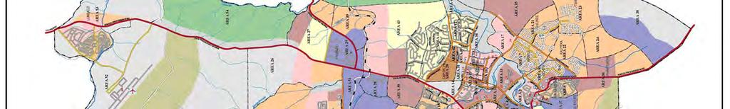
3 THE STUDY ON URBAN DEVELOPMENT MASTER PLAN FOR LILONGWE CITY IN THE REPUBLIC OF MALAWI FINAL REPORT DRAWINGS Table of Contents 1. LOCATION MAP GEOGRAPHICAL MAP OF LILONGWE CITY CURRENT LAND USE MAP OF LILONGWE CITY LAND USE MAP OF LILONGWE CITY ZONING FOR URBAN LAND USE (2030) ZONING FOR OPEN SPACE/ GREENERY ZONING FOR RESIDENTIAL LAND USE ZONING FOR COMMERCIAL LAND USE INDUSTRIAL LAND USE ZONING (2030) EXPANSION OF THE BUILT-UP AREA (URBAN LAND USE) PROPOSED INSTITUTIONAL MEASURES FOR IMPLEMENTATION OF LAND USE ZONING TRANSPORTATION DEVELOPMENT PLAN -LOCATION MAP OF PRIORITY PROJECT URBAN UTILITY DEVELOPMENT PLAN -LOCATION MAP OF PRIORITY PROJECT IMAGE OF FUTURE LILONGWE CITY...16


4 1. Location Map 1


5 2. Geographical Map of Lilongwe City 2
6 3. Current Land Use Map of Lilongwe City 3
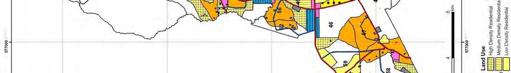
7 Land Use Map of Lilongwe City 4

 5")
8 5. Zoning for Urban Land Use (2030) 5


9 6. Zoning for Open Space/ Greenery 6


10 7. Zoning for Residential Land Use 7


11 8. Zoning for Commercial Land Use 8


12 9. Industrial Land Use Zoning (2030) 9
13 10. Expansion of the Built-up Area (Urban Land Use) 10

14 11. Proposed Institutional Measures for Implementation of Land Use Zoning Matrix Table to Control Building Use/ Activity by Land Use Category Activity/Building Use Classification of Land Use Zoning LDR MDR HDR QUR HRR COMHRC HID LID GOV ARP AGR NST PAR FOR GNO Detached house P P P P P X X X X X X X X X Semi-detached house P P P P P X X X X X X X X X Flats P P P P P X X X X X X X X Hotels/Other Accommodation X X P P P P P X X X X X X Retail shops, small storage*1 P P P P P P P X X X X Retail shops, small storage*2 X P P P P P P P X X X X Retail shops, small storage*3 X X P P P P P X X X X X X X X Retail shops, small storage*4 X X X P P X X X X X X X X Commercial office*5 P P P P X X X X X Commercial office*6 X P P P P X X X X X X Commercial office*7 X X X X X P P P P X X X X X X Commercial office*8 X X X X X P P P P X X X X X X Government Office P P P X X X X X Entertainment/Leisure bldg.*9 X X P P X X X X X X X Entertainment/Leisure bldg.*10 X X X X X P P X X X X X X X Public facilities (Police, fire station, post office) P P P P P P P P X X X X X Church/Religious Bldg.. P P P P P P P X X X X X X X Primary and secondary schools, library, P P P P P P P X X X X X X culture center, museum University/College X X P P P P P P P X X X X X X X Clinics P P P P P P P P X X X X X Hospitals P P P P P X X X X X X Social welfare facilities P P P P P X X X X X X X X Wholesale/Distribution/Large storage facilities X X X X X X P P X X X X X X Light industry X X X X X X X P X X X X X X X Heavy/large-scale industries X X X X X X X P X X X X X X X Small workshop/repair X X X X X P P X X X X X X Petro filling station X X X X X X X X X X X Bus terminal X X X X X X X X X X X X Special utility facilities X X X X X X X X X X X X X Outdoor recreation facilities X X X X X X X X X X X P Agriculture-related buildings X X X X X X X X X X X P X X X X Forestry-related buildings X X X X X X X X X X X P X X P X Note: *1: Floor area under 50m² P *Permitted Note: *2: Floor area over 50m² under 200m² *Special consent required (In condition, permitted) Note: *3: Floor area over 200m² over 2000m² X *Not permitted Note: *4: Floor area over 2000m² Note: *5: Floor area under 50m² Note: *6: Floor area over 50m² under 200m² Note: *7: Floor area over 200m² over 2000m² Note: *8: Floor area over 2000m² Note: *9: Cinema, theatre, dance hall etc. Note: *10: Night clubs, massage parlor, casino, cabaret Exlanation of Land use zoning abbreviation is as follows: LDR: Low density residential, MDR: Medium density residential, HDR: High density residential, QUR: Quasi-ressidential, HRR: High-rise commercial COM: Commercial, HRC: High-rise commercial HID: Heavy industrial, LID: Light industrial GOV: Governmental use, ARP: Airport, AGR: Agriculture, NST: Nature Sanctuary, PAR: Park and recreation, FOR: Forestry, GNO: Greenery/natural open space Floor Area Ratio (FAR) and Building Coverage Ratio (BCR) Regulation on Maximum Ratio of BCR and FAR for Density Control Land Use Category Maximum Ratio Category Sub-Category Abbreviation BCR (%) FAR (%) Low density residential LDR Medium density residential MDR Residential High density residential HDR High-rise residential HRR Quasi-residential QUR Commercial Industry Commercial Heavy indutry COM HID High-rise commercial Light industry HRC LID Government Government GOV ARP ARP - - Agriculture AGR - - Airport Forestry FOR - - Nature Sanctuary NTS - - Park and recreation PAR - - Greenery/natural open space GNO - - Plot Size Regulation Land Use Category Plot Size Regulation Category Sub-Category Abbreviation Minimum Maximum Low density residential LDR 1,000 2,000 Medium density residential MDR 600 1,000 Residential High density residential HDR High-rise residential HRR 10,000 - Quasi-residential QUR
15 Height Control Land Use Category The number of storeies Category Sub-Category Abbreviation allowed above the ground Low density residential LDR 1~2 Medium density residential MDR 1~2 High density residential HDR 1~3 Residential High-rise residential (1) *1 HRR (1) 3~4 High-rise residential (2) *2 HRR (2) 8~12 High-rise residential (3) *3 HRR (3) 5~6 Quasi-residential QUR 1~3 Commercial Industry Commercial Heavy indutry COM HID 3~4 1~3 High-rise commercial Light industry HRC LID 8~12 1~3 Government Government GOV 1~5 *1 HRR(1): located in Area 3 and Area 9 These areas are located just next to LDR. In view of harmonizing cityscape, the height control shall be restricted to 3-to 4-storey restriction. In general, townhouse type residential development shall take place therein. *2 HRR(2): located in Area17, 32 and 37 Since these areas are located very near to City Centre or in the middle of Old Town, the height control shall be 8- to 12-storey restriction *3 HRR(3): located in Area 26 and 43 These areas are very near to the industrial zones. The height control shall be 5 to 6 - storey -to-6- Regulation for Building Line Land Use Category Building Line Category Sub-Category Abbreviation Front (m) Rear (m) Side (m) Low density residential LDR Medium density residential MDR Residential High density residential HDR High-rise residential HRR Quasi-residential QUR Commercial Industry Commercial Heavy indutry COM HID High-rise commercial Light industry HRC LID Government Government GOV Standard for Minimum Requirement for Car Parking Spaces Land Use Category Car parking Category Sub-Category Abbreviation space(cars/plot) Low density residential LDR at least 2 Medium density residential MDR at least 2 High density residential HDR at least 1 Residential at least the same High-rise residential HRR number of units Quasi-residential QUR *5 Commercial Industry Commercial Heavy indutry COM HID *1 *3 High-rise commercial Light industry HRC LID *2 *4 Government Government GOV *1 The number of minimum car spaces shall be calculated from the floor area (m²) of the building concerned by the following formula. *1 N=F/50 N= the minimum car spaces to be needed *2 N=F/40 F= Floor areas (m²) *3 N=F/300 *4 N=F/200 *5 Common public parking space to be established with the ratio of 1 car/ 3 plots 12

16 12. Transportation Development Plan -Location Map of Priority Project Number; Project ID No. OO; Western Bypass, On-going 13
17 Road Development Projects Function ID No Project Function ID No Project North - South Axis (M1) Inner and Outer Ring Roads Radial Roads Urban Roads RD01 Widening of M1 Kanengo RD28 Construction of Parliament Circumferential Road in Area 14, 20 & 31 RD02 Widening of M1 Area18 Roundabout North RD29 Construction of Urban Road in Area 33 RD03 Widening of M1 Area 18 Roundabout - Mchinji Roundabout RD30 Widening of Presidential Drive I(M1 - Kenyatta Road Section) RD04 Widening of M1 Old Town Area RD31 Widening of Presidential Drive II RD05 Widening of M1 Community Center - Chidzanja Road RD32 Improvement of Urban Road in Area 56 & 62 RD06 Widening of M1 South RD33 Widening of Independence Drive & Chilembwe Road RD07 Widening & Extension of Chayamba Road for Inner & Outer Rign Roads RD34 Widening & Upgrading of Kenyatta Road RD08 Extension of Chidzanjya Road for Inner Ring Road RD35 Widening of Youth Drive RD09 Widening of Chidzanjya Road for Inner Ring road RD36 Widening of Paul Kagame North Section RD10 Improvement of Northern Outer Ring Road I RD37 Widening of Mzimba Road Extension Improvement of Northern Outer Ring Road II RD38 Widening of Murray Road RD11 Construction of North Western Arche of Outer Ring Road RD39 Widening of Kawale Road RD12 Construction of South Western Arche of Outer Ring Road RD40 Construction of Lilongwe Town Hall Roundabout Related Road RD13 Improvement of Western Bypass Access Road for Outer Ring Road Urban Roads RD41 Widening of Colby Road & Extension RD14 Widening of Salima Road (M14) RD42 Upgrading to Urban Road in Area 7 & 8 RD15 Widening of S123 in Area 50 & 51 RD43 Upgrading to Urban Road in Area 36 & 37 RD16 Improvement of S123 in Area 50 RD44 Construction of Urban Road in Area 36 RD17 Widening of Mchinji Road (M12) RD45 Upgrading to Urban Road in Area 22 & 24 RD18 Widening of S124 (Likuni Road) in Area 3 RD46 Construction of Connection Road Between Area 24 and Area 38 RD19 Improvement of T361 in Area 53 & 54 RD47 Improvement Area 22 & Area 23 Connection road RD20 Improvement of T363 in Area 61 RD48 Construction of Circumferential Road in Area 61 RD21 Construction of Connection Road with Outer Ring Road in Area 39 RD49 Construction of Outer Ring Road Connection Roads in Area38&Area61 RD22 Construction of Connection Road with Area 25 Market RD50 Upgrading to Primary Community Road in Area 57 RD23 Improvement of Central Urban Road in Area 25 RD51 Urban Road Improvement in Area 58 & 59 RD24 Construction of Central Urban Road Extension in Area 25 RD52 Construction of Primary Community Road to Presidential Drive in Area47 RD25 Upgrading to Urban Road in Area49 RD53 Improvement of Primary Community Road(for Agricultural) in Area55 RD26 Construction of Urban Road in Area 50 & 28 (missing link) RD27 Upgrading to Urban Road in Area 44 (to Kauma market) RD54 Improvement of Primary Community Road(for Agricultural) in Area25&55 14
 LILONGWE CITY Kauma Sewage Treatment Plant (existing) Kamuzu Dam 2 Kamuzu Dam 1 Makanya TW Legend Existing Dam Proposed Dam Pipeline Existing Waste Treatment Plant Proposed")
18 13. Urban Utility Development Plan -Location Map of Priority Project Location of Water Supply Facilities Ntofu Dam Location of Sewage Treatment Plant, Solid Waste Dumping Station Lumbadzi Sewage Treatment Plant (existing) LILONGWE CITY Kauma Sewage Treatment Plant (existing) Kamuzu Dam 2 Kamuzu Dam 1 Makanya TW Legend Existing Dam Proposed Dam Pipeline Existing Waste Treatment Plant Proposed Waste Treatment Plant Gravity Flow City Boundary Diamphwe Dam Service Reservoir Tanks Reservoir Solid Waste Dumping Site (existing) 15


19 14. Image of Future Lilongwe City Sanctuary High Rise Flat Area High Rise Commercial Area Bus terminal 16 Light-industries & Logistics


20 14.1 Image of Future Land Use (High Rise Commercial Area ) High Rise Flat High Rise Business Center Building Office Building Roof garden High Rise Commercials Building High Rise Commercials Building High Rise Commercials Building High Rise Commercial 17
(b) each living unit shall have a minimum floor area of 27 m 2 (290.6 sq.ft.). (B/L No ) (a) the zoning designations R4, R5, R9, or
 each living unit shall have a minimum floor area of 27 m 2 (290.6 sq.ft.). (B/L No ) (a) the zoning designations R4, R5, R9, or") 104. RESIDENTIAL DISTRICT (R4) This District provides for the use and development of two-family dwellings on larger lots in medium density residential areas. 104.1 Uses Permitted: (1) Single family dwellings
104. RESIDENTIAL DISTRICT (R4) This District provides for the use and development of two-family dwellings on larger lots in medium density residential areas. 104.1 Uses Permitted: (1) Single family dwellings
SECTION SIX PERMITTED USES
 70 SECTION SI PERMITTED S 6.1 S Uses which are permitted in the following Zones are identified on the following Permitted Use Tables: CATEGORY TABLE SECTION Zones Table One Section 6.2 Zones Table Two
PART 3 RESIDENTIAL ZONING DISTRICTS. Designation of Residential Zoning Districts and Purpose Statements.
 PART 3 S Section 301. Designation of and Purpose Statements. See Table 3-1 herein this Section for the designations and purpose statements of the respective Residential Zoning Districts which are shown
1558 Vance Rd, Chattanooga, TN 37421
 Prepared by Robert Fisher, KW Commercial Dec 11, 2017 on GCAR CMLS 423-667-8634 [M] 423-664-1550 [O] robert@rkfisher.com Tennessee Real Estate License: 285342 42.5 Acres of Land -Hamilton Place Submarket
ORDINANCE NUMBER 2015-
 1 1 1 1 1 1 1 1 0 0 1 ORDINANCE NUMBER 01- AN ORDINANCE OF ESCAMBIA COUNTY, FLORIDA, AMENDING PART III OF THE ESCAMBIA COUNTY CODE OF ORDINANCES, THE LAND DEVELOPMENT CODE OF ESCAMBIA COUNTY, FLORIDA;
CRD Zoning Map RR-2 - Lot 27 Woodhaven Rd
 CRD Zoning Map RR-2 - Lot 27 Woodhaven Rd Legend SSI SGI Zoning AGRICULTURE Agriculture Agriculture 1 Agriculture 1 (zone variant a) Agriculture 1 (zone variant b) Agriculture 1 (zone
Zoning Bylaw No. 3166
 Zoning Bylaw No. 3166 1) Overview Why a new Zoning Bylaw is Needed Key Improvements Recent Changes Public Consultation New Zoning Map Current Zoning Map Below-grade Parking Area Map Additional Setback
Mohave County General Plan
 63 64 65 66 67 68 69 70 71 The Land Use Diagram is not the County's zoning map. 13 It is a guide to future land use patterns. Zoning and area plan designations may be more restrictive than the land use
Part 7 Uptown Mixed-Use Centre Zones
 TABLE OF CONTENTS PART 7: UPTOWN MIXED-USE CENTRE ZONES... 1. GENERAL PROVISIONS.... PERMITTED USES... 3 3. PROHIBITED USES... 5 4. UCR1 TO UOP ZONE REGULATIONS... 5 4.1 LOT WIDTH, AREA, YARDS, FLOOR AREA
6150 Shallowford Rd, Chattanooga, TN 37421
 Shallowford Commons Suite For Lease or Sale - 1,650 SF 6150 Shallowford Rd, Chattanooga, TN 37421 Listing ID: 30264895 Status: Active Property Type: Office For Lease Office Type: Business Park, Governmental
ARTICLE III: LAND USE DISTRICTS AGRICULTURE AND FOREST DISTRICT (AF-10)
") ARTICLE III: LAND USE DISTRICTS III-153 346 AGRICULTURE AND FOREST DISTRICT (AF-10) 346-1 Intent and Purpose The AF-10 District is intended to retain an area s rural character and conserve the natural
ARTICLE III: LAND USE DISTRICTS III-153 346 AGRICULTURE AND FOREST DISTRICT (AF-10) 346-1 Intent and Purpose The AF-10 District is intended to retain an area s rural character and conserve the natural
2.2 Future Demand Projection Methodology
 SECTION 2 Water Demands Water demands were developed for existing and future conditions based on parcel-level land use information and water meter billing data. CH2M HILL worked extensively with Town of
BOWEN ISLAND MUNICIPALITY BYLAW NO. 440, A Bylaw to amend Land Use Bylaw No. 57, 2002
 BOWEN ISLAND MUNICIPALITY BYLAW NO. 440, 2017 A Bylaw mend Land Use Bylaw No. 57, 2002 WHEREAS, Bowen Island Land Use Bylaw No. 57, 2002 establishes regulations for the use of land and buildings; and WHEREAS,
Farming & Livestock related activities Y Y Y Y Y Y. Commercial Type Animal Facility Y Y Y
 ( = Permitted) TABLE A PERMITTED USES B DISTRICT MU MU2 CC MH/ RV Agricultural Uses (Light) Agricultural Uses (Heavy) Residential Uses Recreational and Institutional Uses RM R C LI MI HI A Farming & Livestock
Town of Cary, North Carolina Rezoning Staff Report 12-REZ-27 Morris Branch Town Council Public Hearing January 24, 2013
 Town of Cary, North Carolina Rezoning Staff Report 12-REZ-27 Morris Branch Town Council Public Hearing January 24, 2013 REQUEST To amend the Town of Cary Official Zoning Map to rezone approximately 9.0
820 Hamilton Ave, Chattanooga, TN 37405
 Prepared by Robert Fisher, KW Commercial Mar 6, 2018 on GCR CMLS 423-667-8634 [M] 423-664-1550 [O] robert@rkfisher.com Tennessee Real Estate License: 285342 North Chatt Industrial Bldg - Rare Find 820
CHAPTER COMMERCIAL AND INDUSTRIAL ZONING DISTRICTS
 Commercial and Industrial Zoning Districts 106.26.010 CHAPTER 106.26 - COMMERCIAL AND INDUSTRIAL ZONING DISTRICTS COMMERCIAL AND INDUSTRIAL ZONING DISTRICTS Sections: 106.26.010 - Purpose 106.26.020 -
25 N 23rd STREET COMMERCIAL-RESIDENTIAL DEVELOPMENT
 SCOPE OF WORK The Owner proposes to develop an existing group of buildings for a Mixed Use and associated Off-Street Parking. The new development shall include 9 Commercial Spaces and 156 brand new apartments
ORDINANCE NUMBER 2015-
 1 0 1 0 1 ORDINANCE NUMBER - AN ORDINANCE OF ESCAMBIA COUNTY, FLORIDA, AMENDING PART III OF THE ESCAMBIA COUNTY CODE OF ORDINANCES, THE LAND DEVELOPMENT CODE OF ESCAMBIA COUNTY, FLORIDA, AS AMENDED; AMENDING
1161 Ridgeway Ave, Signal Mountain, TN 37377
 Comm Development Opportunity on Signal Mtn 1161 Ridgeway Ave, Signal Mountain, TN 37377 Listing ID: 30211975 Status: Active Property Type: Vacant Land For Sale Possible Uses: Multi-Family, Office Gross
To ensure a smooth transition from the County to City jurisdiction for planning and development regulation
 City of Grande Prairie Municipal Development Plan and Land Use Bylaw Concept for transitioning Short Term Annexation Area lands into the City s policy framework and land use development control regime.
Attachment I Land Use Designations
 Attachment I 1997 Land Use Designations Various Building Configurations Representing a Floor-Area Ratio of 1.00 on the Same Lot $ jj 4 Stories 7 X
Results Framework for LAPs Household-level Impacts
 Results Framework for LAPs Household-level Impacts The following results framework shows the indicators that could be used to evaluate LAP impacts at the household level. This matrix has been constructed
GEORGE / GROSVENOR AREA STUDY RECOMMENDATIONS PLANNING CITY OF LONDON DEPARTMENT OF. MAY 1985 r----q
 GEORGE / GROSVENOR AREA STUDY RECOMMENDATIONS CITY OF LONDON DEPARTMENT OF PLANNING MAY 1985 r----q PREFACE On April 9, 1985, the Planning Committee held a public meeting regarding the St. George/Grosvenor
Division 5 Residential Low Density Zone: Assessment Criteria and Assessment Tables
 Division 5 Residential Low Density Zone: Assessment Criteria and Assessment Tables 4.5.1 Residential Low Density Zone The provisions in this division relate to the Residential Low Density Zone as follows
Section Intent
 Section 246. 1. Intent 2. Authority a. It is the intent of these Transfer of Development Rights (TDR s) regulations to encourage the preservation of natural resources and facilitate orderly growth in the
Midwest City, Oklahoma Zoning Ordinance
 2010 Midwest City, Oklahoma Zoning Ordinance 9/2/2010 Table of Contents Section 1. General Provisions... 5 1.1. Citation... 5 1.2. Authority... 5 1.3. Purpose... 5 1.4. Nature and Application... 5 1.5.
Report to: Development Services Committee Report Date: April 21, 2015
 SUBJECT: Preliminary Report Applications for Draft Plan of Subdivision, Zoning By-law Amendment, Plan of Condominium and Site Plan Approval by Urbancorp Inc. 9064-9110 Woodbine Avenue File No s: SU/ZA/CU/SC
5219 Upper Middle Road, Burlington
 5219 Upper Middle Road, Burlington Resident Information Meeting May 23 rd, 2017 7:00pm Corpus Christi Secondary School 5150 Upper Middle Road, Burlington City File No. 520-05/17 Team Members Subject Lands
Land Use Survey Summer 2014
 Land Use Survey Summer 2014 North Ogden City, Utah Robert Scott, City Planner Travis Lund, Planning Intern Contents General Information... 1 Land Use Groups... 1 Urbanized Land Uses... 1 Residential...
SECTION 10 AGRICULTURAL ZONES
 10.1 Agricultural (A) Zone (1) Permitted Uses: abattoir agricultural use cemetery communications facility conservation use farm equipment dealer farm produce outlet farm produce storage feed mill forestry
SECTION 3. Housing. Appendix A LAND USE DEFINITIONS
 SECTION 3 Housing A Appendix A LAND USE DEFINITIONS A-2 Housing Commission Attachment B Appendix A Land Use Definitions INTRODUCTION The Land Use Map (Figure A-1) of Community Vision 2040 illustrates the
Hawkesbury Local Environmental Plan 2012
 New South Wales Hawkesbury Environmental Plan 2012 under the Environmental Planning and Assessment Act 1979 I, the Minister for Planning and Infrastructure, pursuant to section 33A of the Environmental
Future Land Use Categories & Nodes December 23, Future Land Use Categories
 Future Land Use Categories & Nodes December 23, 2015 A note regarding nodes: Descriptions for nodes are located in the general recommendations handout. Node locations are set in part by the Auburn Interactive
ZONING. 317 Attachment 4
 All 37 Attachment 4 SCHEDULE OF REGULATIONS 6 Part 2 3 4 5 6 7 8 9 0 Minimum Yard Dimensions Building Density Height Lot Minimum Floor Area Conditional Uses Area Width Depth Coverage (dwelling units per
Township of Lanark Highlands Zoning By-law No
 7.0 RESIDENTIAL LOW DENSITY (R1) No person shall use any land or erect, alter or use any building or structure in the Residential Low Density - R1 zone except in accordance with the provisions of this
Chapter 2: Existing Land Use
 Chapter 2: Existing Land Use Existing Land Use An inventory of existing land use describes existing patterns of development. The inventory provides useful information to calculate the ultimate population
DISTRICT OF NORTH SAANICH BYLAW NO. 1306
 DISTRICT OF NORTH SAANICH BYLAW NO. 1306 A BYLAW TO AMEND "DISTRICT OF NORTH SAANICH ZONING BYLAW NO. 1255 (2011)" The Council of the District of North Saanich, in open meeting assembled, ENACTS AS FOLLOWS:
ORDINANCE NUMBER 2017-
 1 1 1 1 0 1 0 1 0 ORDINANCE NUMBER 0- AN ORDINANCE OF ESCAMBIA COUNTY, FLORIDA, AMENDING PART III OF THE ESCAMBIA COUNTY CODE OF ORDINANCES, THE LAND DEVELOPMENT CODE OF ESCAMBIA COUNTY, FLORIDA, AS AMENDED;
c. Public Facilities: Community Center; Public Park; Religious Use; Transit Stop. [Amended Ordinance #11-07]
![c. Public Facilities: Community Center; Public Park; Religious Use; Transit Stop. [Amended Ordinance #11-07]](/thumbs/72/66882116.jpg "c. Public Facilities: Community Center; Public Park; Religious Use; Transit Stop. [Amended Ordinance #11-07]") Section 2.04. Intent The s are established to protect, promote and maintain the development of medium density single family dwellings and to provide for limited public and institutional uses that are compatible
Section 2.04. Intent The s are established to protect, promote and maintain the development of medium density single family dwellings and to provide for limited public and institutional uses that are compatible
4.1 Overview. 4.2 Land Use Plan
 4.1 Overview The Sierra Vista Specific Plan provides for a mix of land uses to achieve the desired community form and Plan Area objectives. These land use designations include low-, medium-, and high-density
Build-Out Analysis. Methodology
 Build-Out Analysis Methodology PRINCE WILLIAM COUNTY PLANNING OFFICE 5 County Complex Court Prince William, Virginia 22192-9201 (703) 792-7615 www.pwcgov.org/planning Christopher M. Price, AICP Director
ARTICLE III: LAND USE DISTRICTS 348 AGRICULTURE AND FOREST DISTRICT (AF 5)
") ARTICLE III: LAND USE DISTRICTS III 159 348 AGRICULTURE AND FOREST DISTRICT (AF 5) 348 1 Intent and Purpose The AF 5 District is intended to retain an area s rural character and conserve the natural resources
ARTICLE III: LAND USE DISTRICTS III 159 348 AGRICULTURE AND FOREST DISTRICT (AF 5) 348 1 Intent and Purpose The AF 5 District is intended to retain an area s rural character and conserve the natural resources
STAFF REPORT. Community Development Director PO Box 4755 Beaverton, OR 97076
 STAFF REPORT HEARING DATE: July 7, 2010 TO: Planning Commission STAFF: Jana Fox, Assistant Planner PROPOSAL: Southeast Beaverton Office Commercial Zoning Map Amendment (ZMA2010-0006) LOCATION: The subject
To achieve growth, property development, redevelopment and an improved tax base in the cities and boroughs in the Lehigh Valley.
 Most growth in property valuation is in townships. Between 1991 and 2004, the assessed valuation of the townships in the Lehigh Valley increased by more than $2.8 billion, an increase of 41%. At the same
CITRUS COUNTY COMPREHENSIVE PLAN
 CITRUS COUNTY COMPREHENSIVE PLAN APPENDIX F METHODOLOGIES USED IN THE FUTURE LAND USE ELEMENT REFERENCED IN CHAPTER 10 FUTURE LAND USE Updated: December 2, 1997, Ord. No. 1997-A29 This page left intentionally
Z-5/06 Applications to Amend the Oshawa Official Plan, the Samac Secondary Plan and Zoning By-law No Simcoe Street North Ed Malachowski
 Report To: From: Subject: Development Services Committee Acting Commissioner, Department of Development Services Item: B-3100-0086 Z-5/06 Applications to Amend the Oshawa Official Plan, the Samac Secondary
Jeff Davidson. FOR LEASE Industrial Building. 150 Bunting Rd., St. Catharines. 26,500 sq.ft. $6.00 per sq.ft. M1 Zoning
 150 Bunting Rd., St. Catharines FOR LEASE Industrial Building 26,500 sq.ft. $6.00 per sq.ft. M1 Zoning RE/MAX Niagara Commercial Division 5627 Main Street. Niagara Falls, Ontario L2G 5Z3 P: 905-356-9600
Permitted uses. Adult congregate living facility. Ambulance service. Animal clinics (outpatient care only and no overnight boarding)
") B-3, HIGHWAY SERVICE BUSINESS DISTRICT Intent. The B-3, Highway Service Business District is intended for application along highways carrying large volumes of traffic where establishments may locate to
B-3, HIGHWAY SERVICE BUSINESS DISTRICT Intent. The B-3, Highway Service Business District is intended for application along highways carrying large volumes of traffic where establishments may locate to
Part 4, C-D Conservation District
 The Township is divided into the districts set forth by this chapter and as shown by the district boundaries on the Official Zoning District Map. The zoning districts are: C-D Conservation District A-1
2019 DC Study External Stakeholder Committee Minutes
 Date / Time: October 10 th, 2017 1:30pm 3:30pm Location: Committee Room #1, 2 nd Floor City Hall 2019 DC Study External Stakeholder Committee Minutes Attended: George Kotsifas (Chair), Lois Langdon, Sandy
Proposed Variation to Stage 1 Proposed District Plan VISITOR ACCOMMODATION DRAFT
 Proposed Variation to Stage 1 Proposed District Plan VISITOR ACCOMMODATION Prepared by Ian Johnson, Mitchell Daysh Ltd For Bookabach Ltd Version 0.4 Residential Visitor Accommodation The Variation Alternative
Notice of Public Hearings for Proposed Land Use Change
 Planning and Development Department Community Planning Division 214 North Hogan Street Ed Ball Building, Suite 300 Jacksonville, Florida 32202 Council Legislative Services Division Jacksonville City Council
SECTION CLASSIFICATION OF ZONES For the purpose of this Code the following primary land use zoning districts are hereby established:
 ARTICLE 4 ZONING DISTRICTS SECTION 4.010 CLASSIFICATION OF ZONES For the purpose of this Code the following primary land use zoning districts are hereby established: Primary Zones Abbreviated Designation
Official Community Plan (OCP) LAND USE HANDBOOK
 LAND USE HANDBOOK") Official Community Plan (OCP) LAND USE HANDBOOK APRIL 2018 1 Land use designations are one of the key implementation tools for achieving the growth strategy and managing development in the city. They establish
Official Community Plan (OCP) LAND USE HANDBOOK APRIL 2018 1 Land use designations are one of the key implementation tools for achieving the growth strategy and managing development in the city. They establish
Ensure that the rural economy uses are compatible with any existing permitted residential development.
 ection 2-100 Agricultural Rural-1 The provisions of this ection apply only to the areas now zoned Agricultural Rural-1 that were added to the corporate limits of the Town of Round Hill by the Boundary
Agenda for the Thursday, February 21, 2019, Regular Meeting. Members of the Planning Commission. Briton Williams Acting Chairman
 Planning Commission Agenda for the Thursday, February 21, 2019, Regular Meeting Members of the Planning Commission Leonard Carter, Jr. Timothy V. Key Larry Watts Briton Williams Acting Chairman Bob Clark
Title 6 - Local Government Provisions Applicable to Special Purpose Districts and Other Political Subdivisions
 Title 6 - Local Government Provisions Applicable to Special Purpose Districts and Other Political Subdivisions CHAPTER 29. SOUTH CAROLINA LOCAL GOVERNMENT COMPREHENSIVE PLANNING ENABLING ACT OF 1994 1994
8.1 Single Detached (RSI/A-H, J-K; RS2/A-H, J-K
 8. Residential Zones 8.1 Single Detached (RSI/A-H, J-K; RS2/A-H, J-K 8.1.1 Purpose The zone provides for single detached housing with a range of compatible secondary uses. Subdivision standards vary by
Notice of Public Hearings for Proposed Land Use Change and Rezoning
 Planning and Development Department Community Planning Division 214 North Hogan Street Ed Ball Building, Suite 300 Jacksonville, Florida 32202 Council Legislative Services Division Jacksonville City Council
CASTLES OF CALEDON URBAN DESIGN REPORT
 CASTLES OF CALEDON URBAN DESIGN REPORT PROPOSED RESIDENTIAL DEVELOPMENT CALEDON, ONTARIO 10 JULY, 2015 TABLE CONTENTS: 1.0 DEVELOPMENT 4.0 CONCLUSION 1.1 Introduction 1.2 Castles of Caledon- Urban Design
Part 4.0 DEVELOPMENT REGULATIONS
 M A I N S T R E E T N O R T H Part 4.0 DEVELOPMENT REGULATIONS 4.1 Districts 4.2 Permitted and Prohibited Uses, Standards and Standard Specific Criteria and Other General Provisions 4.3 DPS REGULATIONS
Holding Provisions General Prohibition Exceptions to Prohibition Holding Provisions
 16.1 General Prohibition Portions of this by-law not yet in effect are covered with a blue tone. This version consolidates all amendments and orders of the OMB up to the consolidation date shown below.
RESOLUTION NO. R2010-
 RESOLUTION NO. R2010- A RESOLUTION OF THE CITY OF MANTECA CITY COUNCIL AUTHORIZING SUBMITTAL OF APPLICATION TO THE SAN JOAQUIN LOCAL AGENCY FORMATION COMMISSION IN THE MATTER OF REORGANIZATION, INCLUDING
Minimum Side Yard** Minor Street, Residential Street, or Marginal Access Street. Access Easement
 Sec. 4-6.1 Development Standards for Dwellings. requirements for lot area and lot width are set forth in the following schedule for each district. Where a district density standard has been established,
VOLUME II - APPENDIX B - BASIC ZONING ORDINANCE ARTICLE V. DISTRICT REGULATIONS
 Sec. 5.1000. Multiple-family Residential (R-5). (Ord. No. 4005, 1(Res. No. 8947, Exh. A, 55), 4-3-12) Sec. 5.1001. Purpose. This district is intended to provide for development of multiple-family residential
New Comprehensive Zoning
 New Comprehensive Zoning By-law Project Phase 2: Strategic Directions Development Services Committee June 14, 2016 Task 1: Guiding Principles and Parameters & Trends and Issues in Zoning 1. Drafting of
Town of Kiawah Island Zoning Ordinance Text Amendment and Zoning District Map Amendment Applications
 Town of Kiawah Island Zoning Ordinance Text Amendment and Zoning District Map Amendment Applications Planning Commission Meeting: July 6, 2016 Public Hearing and First Reading: August 2, 2016 Second Reading:
301. Zoning Districts. C-D A-1 R-1 R-V B-1 I-1
 301. Zoning Districts. The Township is divided into the districts set forth by this chapter and as shown by the district boundaries on the Official Zoning District Map. The zoning districts are: C-D Conservation
September 10, Planning and Land Development Regulation Commission (PLDRC)
") Page 1 of 11 GROWTH AND RESOURCE MANAGEMENT DEPARTMENT PLANNING AND DEVELOPMENT SERVICES DIVISION CURRENT PLANNING ACTIVITY 123 W. Indiana Avenue, DeLand, FL 32720 (386) 736-5959 PLDRC HEARING: CASE NO:
Page 1 of 11 GROWTH AND RESOURCE MANAGEMENT DEPARTMENT PLANNING AND DEVELOPMENT SERVICES DIVISION CURRENT PLANNING ACTIVITY 123 W. Indiana Avenue, DeLand, FL 32720 (386) 736-5959 PLDRC HEARING: CASE NO:
MONTEREY COUNTY PLANNING COMMISSION
 MONTEREY COUNTY PLANNING COMMISSION Meeting: October 25, 2006 Time: 9:10 A.M. Agenda Item No.: 1 Project Description: Conduct a workshop regarding the County s regulations for covered parking (Chapter
MARK TWAIN LAKE MASTER PLAN CLARENCE CANNON DAM AND MARK TWAIN LAKE MONROE CITY, MISSOURI
 MARK TWAIN LAKE MASTER PLAN CLARENCE CANNON DAM AND MARK TWAIN LAKE MONROE CITY, MISSOURI CHAPTER 4 LAND ALLOCATION, LAND CLASSIFICATION, WATER SURFACE, AND EASEMENT LANDS This Master Plan is a land use
Revised Code of Ordinances, City of Hallowell (1997) SUBCHAPTER II RESIDENTIAL DISTRICTS DIVISION A (RESERVED)
 SUBCHAPTER II RESIDENTIAL DISTRICTS DIVISION A (RESERVED)") SUBCHAPTER II RESIDENTIAL DISTRICTS DIVISION A (RESERVED) [Derivation: Ord. No. 12-10, eff. 10/19/2012] SECTIONS 9-211 THROUGH 9-230 (Reserved) DIVISION B MEDIUM DENSITY RESIDENTIAL DISTRICT (R1) SECTION
SUBCHAPTER II RESIDENTIAL DISTRICTS DIVISION A (RESERVED) [Derivation: Ord. No. 12-10, eff. 10/19/2012] SECTIONS 9-211 THROUGH 9-230 (Reserved) DIVISION B MEDIUM DENSITY RESIDENTIAL DISTRICT (R1) SECTION
Residential-1 District
 Residential-1 District City of Barnum, Minnesota Zoning District Information Sheet It is the purpose of the R-1 District to encourage the establishment and the preservation of residential neighborhoods
MUNICIPAL DISTRICT OF ROCKY VIEW NO. 44 ELBOW VALLEY WEST DIRECT CONTROL DISTRICT BYLAW C
 This document has been consolidated for convenience only. A current listing of any and all amendments can be obtained from the Municpal District Office Bylaw No. Date of Approval Amendment Type Bylaw C-6042-2005
Medium Density Residential Development Opportunity
 Medium Density Residential Development Opportunity 2 Land Tracts totaling 747 Acres Available individual or whole. 138 Park Farm Lane Stafford, VA 22406 Presented by: Wilson Greenlaw, CCIM Vice President
THE CORPORATION OF THE TOWNSHIP OF LANGLEY
 THE CORPORATION OF THE TOWNSHIP OF LANGLEY A Bylaw to Impose Development Cost Charges for Highway, Drainage, Sewage, Water and Park Facilities EXPLANATORY NOTE Bylaw 2012 No. 4963 repeals the Langley Development
LAND USE AMENDMENT SPRINGBANK HILL (WARD 6) ELMONT DRIVE SW AND 69 STREET SW BYLAW 114D2017
 ELMONT DRIVE SW AND 69 STREET SW BYLAW 114D2017") Page 1 of 8 EXECUTIVE SUMMARY This land use amendment application proposes to redesignate and subdivide 1.15 hectares of land located within the southwest community of East Springbank to accommodate 17
Page 1 of 8 EXECUTIVE SUMMARY This land use amendment application proposes to redesignate and subdivide 1.15 hectares of land located within the southwest community of East Springbank to accommodate 17
Suburban Commercial Center ( CE-S ) Permitted Principal Uses and Structures
 Permitted Principal Uses and Structures") Division 12. Suburban Commercial Center ( CE-S ) 2.9.1 Purpose Suburban commercial centers provide regional commercial destinations with design and site elements compatible with suburban character. Dimensional
Division 12. Suburban Commercial Center ( CE-S ) 2.9.1 Purpose Suburban commercial centers provide regional commercial destinations with design and site elements compatible with suburban character. Dimensional
Missing Middle Housing Types Showcasing examples in Springfield, Oregon
 Missing Middle Housing Types Showcasing examples in Springfield, Oregon MissingMiddleHousing.com is powered by Opticos Design Illustration 2015 Opticos Design, Inc. Missing Middle Housing Study Prepared
FILE APP. DATE M.O. M.O. Local Electoral Area : Comeraghs Electoral Are 17/440 15/08/ /344
 TIME : 09:15:08 PAGE : 1 Local Electoral Area : Comeraghs Electoral Are 17/440 John Cummins P 22/06/2017 to construct a cubicle house, slatted tank and associated site works Carriganonshagh Kilmacthomas
Chapter RESIDENTIAL ZONING DISTRICTS
 Chapter 18.16 RESIDENTIAL ZONING DISTRICTS Sections: 18.16.010 Purpose of Chapter 18.16.020 Purpose of Residential Zoning Districts 18.16.030 Regulations for Residential Zoning Districts 18.16.040 Residential
SCHEDULE A TO BY-LAW NUMBER (Amended by By-law ) CLASSES OF PERMITS AND PERMIT FEES
 CLASSES OF PERMITS AND PERMIT FEES") SCHEDULE A TO BY-LAW NUMBER 2010-24 (Amended by By-law 2016-40) CLASSES OF PERMITS AND PERMIT FEES 1. Except where a minimum flat fee is indicated for the Occupancy Classification or Type of Construction,
SCHEDULE A TO BY-LAW NUMBER 2010-24 (Amended by By-law 2016-40) CLASSES OF PERMITS AND PERMIT FEES 1. Except where a minimum flat fee is indicated for the Occupancy Classification or Type of Construction,
City geography and economic policy. Council of Capital City Lord Mayors John Daley, CEO Parliament House, Canberra 14 September 2015
 City geography and economic policy Council of Capital City Lord Mayors John Daley, CEO Parliament House, Canberra 14 September 2015 City limits Australia s economy is increasingly dominated by services
1404 James Blvd, Signal Mountain, TN 37377
 Have The Best Restaurant Property on Signal Mtn 1404 James Blvd, Signal Mountain, TN 37377 Listing ID: 29997707 Status: Active Property Type: Retail-Commercial For Sale Retail-Commercial Type: Mixed Use,
25 Leonard Avenue - Official Plan Amendment and Zoning Amendment Applications - Preliminary Report
 STAFF REPORT ACTION REQUIRED 25 Leonard Avenue - Official Plan Amendment and Zoning Amendment Applications - Preliminary Report Date: March 8, 2017 To: From: Wards: Reference Number: Toronto and East York
AMENDMENT TO THE CITY OF CAMBRIDGE ZONING BY-LAW
 AMENDMENT TO THE CITY OF CAMBRIDGE ZONING BY-LAW The Cambridge West lands are located on the west side of the City of Cambridge and represent some of the last remaining greenfield lands within the City
DEVELOPMENT AGREEMENT APPLICATION
 151-11172 LYNNETT ROAD, SPRYFIELD DEVELOPMENT AGREEMENT APPLICATION JULY 28, 2016 1 Spectacle Lake Drive Dartmouth, NS B3B 1X7 Phone: 902-835-9955 Fax: 902-835-1645 www.wspgroup.com 151-11172 July 28,
R-I Single-Family Dwelling District Section
 R-I Single-Family Dwelling District Section 102-266 270 $ Single-family dwellings and accessory uses. $ Churches, including educational and daycare buildings, and bingo fund raising. $ Schools of general
2-1 TITLE 4 ZONING CODE 2-2
 2-1 TITLE 4 ZONING CODE 2-2 Chapter 2 RESIDENTIAL ZONING DISTRICTS Sec. 2-1: Sec. 2-2: Sec. 2-3: Sec. 2-4: Sec. 2-5: Sec. 2-6: Sec. 2-7: Sec. 2-8: Purpose Agriculture/Forestry Zoning District (AF) Farm,
Department of Planning & Development VILLAGE OF SOMERS REZONING PROCEDURES
 VILLAGE OF SOMERS Department of Planning & Development May 2015 VILLAGE OF SOMERS REZONING PROCEDURES 1. Contact the Kenosha County Department of Planning & Development and check with staff to determine
Revised Notice of Public Hearings for Proposed Land Use Change
 ** REVISED NOTICE - CHANGE OF CIM MEETING DATE and LOCATION ** Planning and Development Department Community Planning Division 214 North Hogan Street Ed Ball Building, Suite 300 Jacksonville, Florida 32202
From Policy to Reality
 From Policy to Reality Updated ^ Model Ordinances for Sustainable Development 2000 Environmental Quality Board 2008 Minnesota Pollution Control Agency Funded by a Minnesota Pollution Control Agency Sustainable
SECTION 9 RESIDENTIAL R5 ZONE
 SECTION 9 RESIDENTIAL R5 ZONE 9.1 GENERAL PURPOSE OF THE R5 ZONE This R5 Zone provides for and regulates medium density residential development in the form of cluster townhouses. Different intensities
O S O B N Í L I S T A
 [ [ [ [ % < 7 2 9 < /, 6 7 $ [ [ ' 2 0 2 9 1, /, 6 7 $ EXPLANATORY NOTES: BUILDINGS The Building Census Questionnaire is to be filled in by the building owner. If the building is run by a building manager,
Chapter 8 The Residential District Requirements
 Chapter 8 The Residential District Requirements ECTION: 9-8-1 General Purpose tatement 9-8-2 General Cross-reference Guide for Additional Regulations. 9-8-3 Residential District Regulations 9-8-4 E-1 Estate
Gadsden County Planning Commission Agenda Report
 Gadsden County Planning Commission Agenda Report Date of Meeting: June 16, 2016 To: From: Subject: Honorable Chairperson and Members of the Planning Commission Allara Mills Gutcher, AICP, Planning & Community
City of Sacramento Zoning Code - Zoning Descriptions Excerpt from website on April 5, 2010
 City of Sacramento Zoning Code - Zoning Descriptions Excerpt from website on April 5, 2010 RE Rural Estates Zone. This is a very low density residential zone. It is intended to be applied primarily to
M A N I T O B A ) Order No. 14/13 ) THE PUBLIC UTILITIES BOARD ACT ) February 4, 2013
 Order No. 14/13 ) THE PUBLIC UTILITIES BOARD ACT ) February 4, 2013") M A N I T O B A ) Order No. 14/13 ) THE PUBLIC UTILITIES BOARD ACT ) BEFORE: Susan Proven, P.H.Ec., Acting Chair Marilyn Kapitany, B.Sc. (Hons.), M.Sc., Member RURAL MUNICIPALITY OF PEMBINA LOCAL URBAN
M A N I T O B A ) Order No. 14/13 ) THE PUBLIC UTILITIES BOARD ACT ) BEFORE: Susan Proven, P.H.Ec., Acting Chair Marilyn Kapitany, B.Sc. (Hons.), M.Sc., Member RURAL MUNICIPALITY OF PEMBINA LOCAL URBAN
W James Street Lancaster, PA 17603
 300-308 W James Street Lancaster, PA 17603 For Sale $1,395,000 Apartment Building Restaurant & Equipment Liquor License Building Information Building Size: 9,700 +/- SF Total 4,700 +/- SF Restaurant Exterior: