TOWN OF MOUNT PLEASANT, SOUTH CAROLINA COMMITTEES OF COUNCIL MEETINGS
|
|
|
- Ruth Quinn
- 5 years ago
- Views:
Transcription


1 TOWN OF MOUNT PLEASANT, SOUTH CAROLINA COMMITTEES OF COUNCIL MEETINGS Municipal Complex Building A - Public Meeting Room Ann Edwards Lane, Mount Pleasant, SC ************************** MONDAY, MARCH 31, 2014 Annexation Committee Recreation Committee Police, Judicial, and Legal Committee Economic Development Committee Planning and Development Committee Council Chambers Water Supply Committee 8:00 a.m. 8:15 a.m. 8:30 a.m. 9:00 a.m. 9:30 a.m. 12:30 p.m. **************** The following Committees will not meet: Bids and Purchases Committee Finance Committee Fire Committee Human Resources Committee Public Services Committee Transportation Committee 100 Ann Edwards Lane Mount Pleasant, South Carolina tel (843) fax (843)
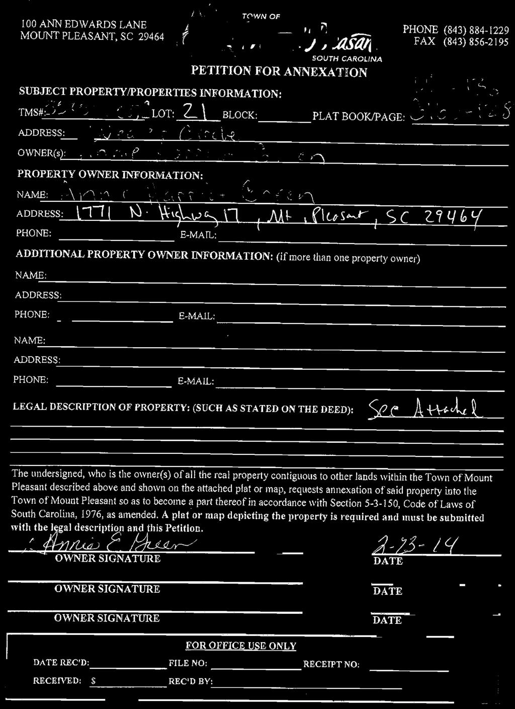
2 TOWN OF MOUNT PLEASANT, SOUTH CAROLINA MEETING NOTICE ANNEXATION COMMITTEE MONDAY, MARCH 31, :00 a.m. Municipal Complex Building A - Public Meeting Room Ann Edwards Lane, Mount Pleasant, SC * * * * * * * * * * * * * * * A G E N D A 1. Approval of Minutes from the March 3, 2014 meeting 2. Request to annex three parcels of land comprising approximately 2.92 acres, located off of Weaver Circle and Hungryneck Boulevard, and described as follows: (1) an approximately 0.92 acre parcel of land known as Lot 23, Smithville subdivision, and identified by TMS No ; (2) an approximately 1.06 acre parcel of land known as Lot 22, Smithville subdivision, and identified by TMS No ; and (3) an approximately 0.94 acre parcel of land known as Lot 21, Smithville subdivision, and identified by TMS No Adjourn 100 Ann Edwards Lane Mount Pleasant, South Carolina tel (843) fax (843)

3


4

5 1 of 2 3/27/2014 8:17 AM TMS No Copyright 2004 Charleston County GIS 4045 Bridge View Drive North Charleston, SC PARCEL NUMBER : PARCEL ID: STREET NUMBER: 0 STREET NAME: N HIGHWAY 17 PROP UNIT: PROP CITY: PROP ZIP: SITE NAME: APPROX 470 FT S 1285 FT E VENNING RD GENERAL USE: VCR MOBILE HOMES: 0 SUBDIVISION: SMITHVILLE LEGAL DESCRIPTION: LOT 23 LGL HI ACRES: 0.92 LGL MAR ACRES: 0 LGL WATER ACRES: 0 LGL SWAMP ACRES: 0 LGL TOTAL ACRES: 0.92 TAX DISTRICT: 13 JURISDICTION: CTA PLAT BOOK: NONE OWNER ON 1ST: GREEN IDA DELL AND JEROME L OWNER2 ON 1ST:
6 2 of 2 3/27/2014 8:17 AM CURRENT OWNER1: CURRENT OWNER2: SALE DATE: 12/5/1974 DEED BOOK: U WILL CODE: WILL DATE: C O NAME: MAIL STREET NUMBER: 1771 MAIL STREET NAME: N HIGHWAY 17 MAIL UNIT: MAIL CITY: MT PLEASANT MAIL STATE: SC MAIL ZIP: MAIL COUNTRY: MAIL POSTAL CODE: SALE PRICE: 650 MULT LOT: 0 SPLIT CODE: MLOD GROUP: FINAL VALUE: BUILD COUNT: 0 AG USE VAL: 0 AG MARKET TOT: 0 LR APPROVE: N YEAR BUILT: 0 BEDROOMS: 0 FULL BATHS: 0 THREE QTR BATHS: 0 HALF BATHS: 0 TOTAL FINISH AREA: 0 LIVING AREA: 0 CONDO-BEDROOM: 0 CONDO FULL BATH: 0 CONDO H-BATH: 0 CAP LR VAL: 0 CAP ASSESSED VALUE: 0 CAP OTHER VALUE: 39900


7
8

9 1 of 2 3/27/2014 8:18 AM TMS No Copyright 2004 Charleston County GIS 4045 Bridge View Drive North Charleston, SC PARCEL NUMBER : PARCEL ID: STREET NUMBER: 0 STREET NAME: N HIGHWAY 17 PROP UNIT: PROP CITY: PROP ZIP: SITE NAME: 550FT S APPROX 1500FT E VENNING RD GENERAL USE: VCR MOBILE HOMES: 0 SUBDIVISION: SMITHVILLE LEGAL DESCRIPTION: LT 22 LGL HI ACRES: 1.06 LGL MAR ACRES: 0 LGL WATER ACRES: 0 LGL SWAMP ACRES: 0 LGL TOTAL ACRES: 1.06 TAX DISTRICT: 13 JURISDICTION: CTA PLAT BOOK: NONE OWNER ON 1ST: GREEN ANNETTE OWNER2 ON 1ST: JEANETTE
10 2 of 2 3/27/2014 8:18 AM CURRENT OWNER1: CURRENT OWNER2: SALE DATE: 11/24/1986 DEED BOOK: C WILL CODE: WILL DATE: C O NAME: MAIL STREET NUMBER: 1771 MAIL STREET NAME: N HIGHWAY 17 MAIL UNIT: MAIL CITY: MT PLEASANT MAIL STATE: SC MAIL ZIP: MAIL COUNTRY: MAIL POSTAL CODE: SALE PRICE: 0 MULT LOT: 0 SPLIT CODE: MLOD GROUP: FINAL VALUE: BUILD COUNT: 0 AG USE VAL: 0 AG MARKET TOT: 0 LR APPROVE: N YEAR BUILT: 0 BEDROOMS: 0 FULL BATHS: 0 THREE QTR BATHS: 0 HALF BATHS: 0 TOTAL FINISH AREA: 0 LIVING AREA: 0 CONDO-BEDROOM: 0 CONDO FULL BATH: 0 CONDO H-BATH: 0 CAP LR VAL: 0 CAP ASSESSED VALUE: 0 CAP OTHER VALUE: 44000
11
12
13 1 of 2 3/27/2014 8:19 AM TMS No Copyright 2004 Charleston County GIS 4045 Bridge View Drive North Charleston, SC PARCEL NUMBER : PARCEL ID: STREET NUMBER: 0 STREET NAME: WEAVER CIR PROP UNIT: PROP CITY: PROP ZIP: SITE NAME: GENERAL USE: VCR MOBILE HOMES: 0 SUBDIVISION: SMITHVILLE LEGAL DESCRIPTION: LOT 21 LGL HI ACRES: 0.94 LGL MAR ACRES: 0 LGL WATER ACRES: 0 LGL SWAMP ACRES: 0 LGL TOTAL ACRES: 0.94 TAX DISTRICT: 21 JURISDICTION: CTA PLAT BOOK: NONE OWNER ON 1ST: GREEN ANNIE HARRIOTT OWNER2 ON 1ST: A/K/A HARRIETT
14 2 of 2 3/27/2014 8:19 AM CURRENT OWNER1: CURRENT OWNER2: SALE DATE: 11/24/1986 DEED BOOK: G WILL CODE: WILL DATE: C O NAME: MAIL STREET NUMBER: 1771 MAIL STREET NAME: N HIGHWAY 17 MAIL UNIT: MAIL CITY: MT PLEASANT MAIL STATE: SC MAIL ZIP: MAIL COUNTRY: MAIL POSTAL CODE: SALE PRICE: 0 MULT LOT: 0 SPLIT CODE: MLOD GROUP: FINAL VALUE: BUILD COUNT: 0 AG USE VAL: 0 AG MARKET TOT: 0 LR APPROVE: N YEAR BUILT: 0 BEDROOMS: 0 FULL BATHS: 0 THREE QTR BATHS: 0 HALF BATHS: 0 TOTAL FINISH AREA: 0 LIVING AREA: 0 CONDO-BEDROOM: 0 CONDO FULL BATH: 0 CONDO H-BATH: 0 CAP LR VAL: 0 CAP ASSESSED VALUE: 0 CAP OTHER VALUE: 40500
15 TOWN OF MOUNT PLEASANT, SOUTH CAROLINA MEETING NOTICE RECREATION COMMITTEE MONDAY, MARCH 31, :15 a.m. Municipal Complex Building A - Public Meeting Room Ann Edwards Lane, Mount Pleasant, SC * * * * * * * * * * * * * * * A G E N D A 1. Approval of Minutes from the March 3, 2014 meeting 2. Facility Rental Requests a. Senior Center 1. Women s Auxiliary Board East Cooper Hospital November 1, Oceanside Baptist Church April 6, 2014 April 5, 2015 b. Review and report 1. Young Life use of Park West Pavilion - continued use until May 5, Christian Science Group use of Miriam Brown Center - continued use until April, Program/projects update 4. Adjourn 100 Ann Edwards Lane Mount Pleasant, South Carolina tel (843) fax (843)
16 RECREATION COMMITTEE PROGRAM REPORT APRIL 1, 2014 ATHLETIC PARTICIPATION REPORT FOR MARCH 1. Youth Baseball 2014 = Youth Basketball 2014 = 1, = 1, Youth Lacrosse 2014 = = Youth Soccer 2014 = = 1,048 (69) 5. Youth Softball 2014 = = Youth Track & Field 2014 = = 92 9 TOTAL YOUTH 2014 = 3, = 3, Adult Flag Football 2014 = = Adult Soccer 2014 = 267* 2013 = 420 (153) 9. Adult Softball 2014 = 411* 2013 = 600 (189) *Not a final number TOTAL ADULTS 2014 = = 1,098 (336) 10. Tennis 2014 = = PROGRAMMING PARTICIPATION REPORT FOR MARCH 1. Swim Lessons 2014 = = 629 (12) 2. Senior Center Members 2014 = 2, = 1, UPCOMING EVENTS IN APRIL a. April 2 Easter Egg Hunt at Alhambra Hall b. April 14 Spring Break Camps at various locations c. April 15 Free Skateboarding Day at the R. L. Jones Center d. April 25 Sock Hop at the Town Hall Gym FACILITY STATUS a. All Town/other fields are currently open except for Jones 4. PROGRAM/ATHLETIC REGISTRATIONS April 6 21, Unified/Therapeutic Kickball, FUNdamental T Ball and Machine Pitch, Youth Basketball Registration
17 TOWN OF MOUNT PLEASANT, SOUTH CAROLINA MEETING NOTICE POLICE, JUDICIAL, & LEGAL COMMITTEE MONDAY, MARCH 31, :30 a.m. Municipal Complex Building A - Public Meeting Room Ann Edwards Lane, Mount Pleasant, SC * * * * * * * * * * * * * * * A G E N D A 1. Approval of Minutes from the March 3, 2014 meeting 2. Police matters a. Employee years of service recognition b. Approval to expend seized asset funds for the purpose of acquiring additional K9s 3. Judicial matters No agenda items 4. Legal matters 5. Adjourn a. Discussion regarding the original footprint of Memorial Waterfront Park 100 Ann Edwards Lane Mount Pleasant, South Carolina tel (843) fax (843)
18 TOWN OF MOUNT PLEASANT, SOUTH CAROLINA MEETING NOTICE ECONOMIC DEVELOPMENT COMMITTEE MONDAY, MARCH 31, :00 a.m. Municipal Complex Building A - Public Meeting Room Ann Edwards Lane, Mount Pleasant, SC * * * * * * * * * * * * * * * A G E N D A 1. Approval of Minutes from the February 3, 2014 meeting 2. Presentation by Mount Pleasant Business Association John Evans and Patti Stanford 3. Executive session contractual matters pertaining to economic development prospects 4. Adjourn 100 Ann Edwards Lane Mount Pleasant, South Carolina tel (843) fax (843)
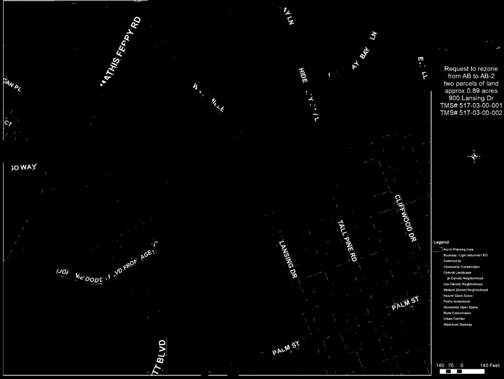
19 TOWN OF MOUNT PLEASANT, SOUTH CAROLINA MEETING NOTICE PLANNING AND DEVELOPMENT COMMITTEE MONDAY, MARCH 31, :30 a.m. Municipal Complex Building C Council Chambers 100 Ann Edwards Lane, Mount Pleasant, SC * * * * * * * * * * * * * * * A G E N D A 1. Approval of Minutes from the March 3, 2014 meeting 2. Employee years of service recognition 3. Presentation by Michelle Mapp with South Carolina Community Loan Fund 4. Review of the Urban Corridor Overlay District text amendment regarding parking requirements for multifamily units and one way streets. 5. Review of Planning Commission recommendations from the March 19, 2014 meeting a. Request to rezone from AB, Areawide Business District, to AB-2, Areawide Business-2 District, two parcels of land comprising approximately 0.89 acres, located at 900 Lansing Drive; one parcel comprising approximately 0.48 acres, known as Part Lot 9, Block P, The Groves subdivision, and identified by TMS No ; the other parcel comprising approximately 0.41 acres, known as Lot 8, Block P, The Groves subdivision, and identified by TMS No Ann Edwards Lane Mount Pleasant, South Carolina tel (843) fax (843)
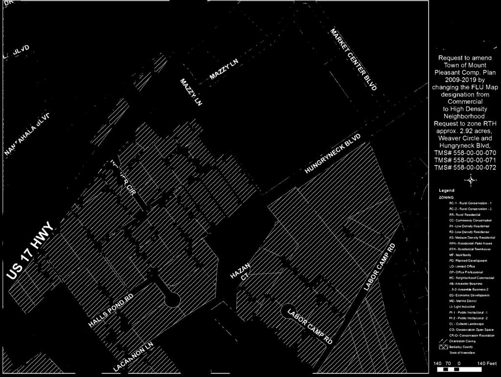
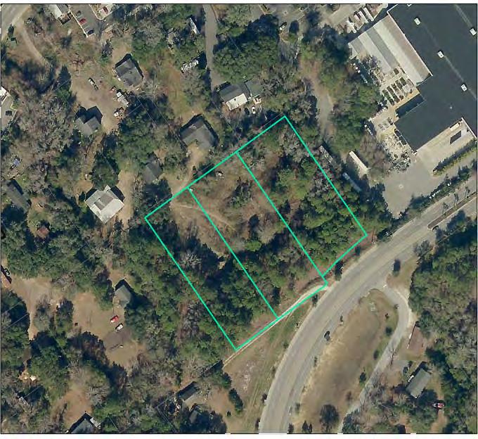
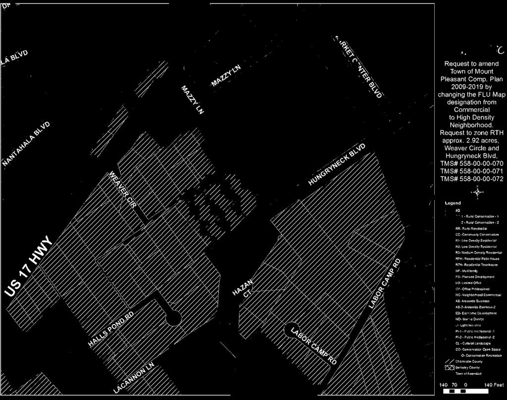
20 b. Request to amend the Town of Mount Pleasant Comprehensive Plan by changing the Future Land Use Map designation of the three parcels described below from Commercial to High Density Neighborhood. Also request to zone RTH, Townhouse For Sale Residential District, three parcels of land comprising approximately 2.92 acres, located off of Weaver Circle and Hungryneck Boulevard, and described as follows: (1) an approximately 0.92 acre parcel of land known as Lot 23, Smithville subdivision, and identified by TMS No ; (2) an approximately 1.06 acre parcel of land known as Lot 22, Smithville subdivision, and identified by TMS No ; and (3) an approximately 0.94 acre parcel of land known as Lot 21, Smithville subdivision, and identified by TMS No Request from Jupiter Holdings, LLC for relief from the requirement to construct a roadway connection to Sweetgrass Basket Parkway 7. Impact Assessment Process Review Update 8. Staff Update on status of Use Table and Comprehensive Plan Update 9. Adjourn 100 Ann Edwards Lane Mount Pleasant, South Carolina tel (843) fax (843)
21 DISCLAIMER: These minutes are considered a draft until reviewed and approved by the Planning Commission at its next regularly scheduled meeting. TOWN OF MOUNT PLEASANT, SOUTH CAROLINA PLANNING COMMISSION MARCH 19, 2014 DRAFT MINUTES Present: Absent: Staff: Roy Neal, Chair, Alice Richter-Lehrman, Ben Bryson, Howard Chapman, Nick Collins, Phil Siegrist, Bob Brimmer (entered at 5:06 pm), Todd Richardson (entered at 5:10 pm) Cheryll Woods-Flowers (excused) David Pagliarini, Kent Prause, Kelly Cousino, Kevin Mitchell Mr. Neal called the meeting to order at 5:04 p.m. 1. Approval of Minutes Mr. Collins moved for approval of the minutes. Mr. Chapman seconded the motion. All in favor. 2. Correspondence A. Update on Planning Commission Recommendations Ms. Cousino reviewed the Town Council decisions with the Commission. She stated that Town Council did not take action on the waiver request for Six Mile Subdivision and rescinded their previous motion, so final reading will be entertained at the April Town Council meeting. Mr. Chapman asked if the Six Mile density was reduced. Ms. Cousino answered that the request to amend the Comprehensive Plan was denied, so the density will remain at 3 units per acre. B. Correspondence and general public statements Mr. Brimmer entered at this time (5:06 p.m.). Ms. Cousino reviewed correspondence received and stated that Item 4A has been withdrawn and Item 5F has requested deferral. Mr. Neal recognized Mr. Siegrist for his eight years of service as a Planning Commission member. Mr. Siegrist thanked the Commission and staff. Mr. Richardson entered at this time (5:10 p.m.). Ms. Myra Richardson, 2755 Earl Jones Lane, stated that Weaver Circle does not extend to the new mattress store. She stated that the portion from the mattress store is a private drive. She stated that the access was provided through a court action to Rosalind and Timothy Snipe. She stated that she was not sure how access would be provided for the proposed project. Mr. Steve Brock, 34 Hopetown Road, stated that the Comprehensive Plan authorizes municipal zoning and must be amended prior to a zoning change. He stated one request is the relationship of the zoning to the Comprehensive Plan and suggested that the recommendation should be that it does not comply if high density is still proposed. He further suggested that, by law, a change to the Comprehensive Plan requires a positive recommendation from the Commission and suggested that without a public hearing by the Commission, it is difficult to make a recommendation on the
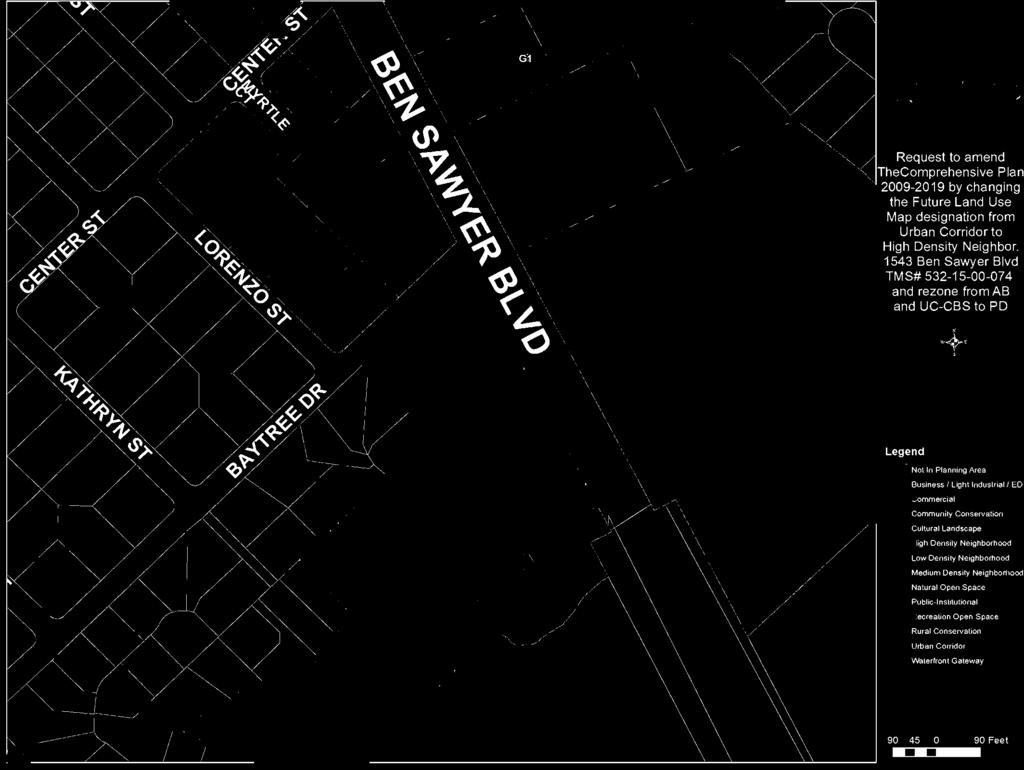
22 DRAFT MINUTES Planning Commission March 19, 2014 Page 2 of 16 Comprehensive Plan change. He suggested that Hungryneck Boulevard was built as a traffic reliever for US17 and suggested that the current proposed use was not in keeping with the intended use of Hungryneck Boulevard and further suggested that the amount of commercial could be considered spot zoning. He suggested that Hungryneck Boulevard should remain as a traffic reliever as it was intended. 3. Unfinished Business a. COMPREHENSIVE PLAN AMENDMENT REQUEST; REZONING REQUEST PUBLIC HEARING: Request to amend the Town of Mount Pleasant Comprehensive Plan by changing the Future Land Use Map designation from Urban Corridor to High Density Neighborhood for an approximately 1.31 acre parcel of land known as Tract 1, located at 1543 Ben Sawyer Boulevard, and identified by TMS No Also request to rezone the aforementioned parcel from AB, Areawide Business District, and UC-CBS, Coleman Boulevard-Ben Sawyer Boulevard Urban Corridor Overlay District, to PD, Planned Development District. DEFERRED FROM PLANNING COMMISSION MEETING. This item was withdrawn by the applicant. 4. Requests A. PRELIMINARY PLAT APPROVAL REQUEST: Request approval of preliminary plat for Old Georgetown Subdivision, a development containing 31 detached single-family residential lots zoned PD-CD, Planned Development Conservation Design District, to be located on an approximately acre parcel of land, known as Lot 8, Seashore subdivision, located on Old Georgetown Road approximately 250 feet northeast of its intersection with Children Road, and identified by TMS No Mr. Mitchell reviewed staff comments as follows: HISTORY This property received final reading for annexation and PD-CD zoning at the September 10, 2013 meeting of Town Council. A sketch plan was approved on September 18th 2013, and a revised sketch plan was approved on November 20 th, PROPERTY DESCRIPTION The property is approximately 6 acres of high ground abutting 4.31 acres of jurisdictional wetlands. It is accessible from Old Georgetown Road. PROPOSAL The proposal is to receive Preliminary Plat approval for thirty one (31) detached single family residential lots. The street and drainage system is planned to be dedicated to the Town upon completion. Ponds will be privately owned and maintained by the HOA. It has a single point of access from Old Georgetown Road and right of way extending to the adjacent property for a future connection. Proposal also includes a request for approval of the road name Johannah Gold Drive.


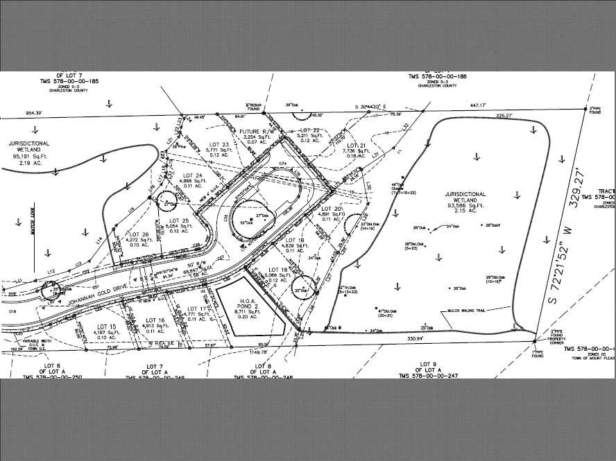
23 DRAFT MINUTES Planning Commission March 19, 2014 Page 3 of 16 STAFF COMMENTS 1. Sketch Plan comments are addressed. 2. Preliminary Plat generally conforms to the approved Sketch Plan. Consolidation and relocation of stormwater ponds has changed some lot layout but the number of lots remains the same. See drawings below. Approved Sketch Plan 11/20/2013 Proposed Preliminary Plat 3/19/ The engineer is exploring changes to reduce the use of a retaining wall along the pond perimeter. This is for safety and aesthetic reasons. 4. Roadway entrance and sidewalk connection with Old Georgetown Road will require an encroachment permit from the SCDOT and Town. 5. The pavement marking to designate on-street parking stalls are to be maintained by the HOA and the parking regulation shall be through the subdivision Covenants and Restrictions. 6. Pedestrian trail is no longer shown on lots 21, 22, and 23, which results in the loss of some connectivity, but eliminates the need for an easement. Mr. Bryson asked why the need for on-street parking. Mr. Mitchell answered that it is the preference of the developer. Mr. Chapman asked about the sidewalk being omitted near the HOA property. Mr. Mitchell answered that it is the developer preference and the planned development allows for sidewalks on one side. Mr. Chapman moved for approval including all staff comments with the stipulation that the sidewalk be extended along the pond and HOA property where it is currently omitted. Mr. Collins seconded the motion. Mr. Pagliarini stated that stated that a preliminary plat can be conditioned and asked if this was the stipulation. Mr. Chapman answered in the affirmative and stated that it should be stipulated unless there is an engineering issue regarding the wetlands that would prevent the construction of the sidewalk in that location.
24 DRAFT MINUTES Planning Commission March 19, 2014 Page 4 of 16 Mr. Richardson suggested that another issue might be the impact to the significant tree located in proximity. Mr. Chapman moved to amend his motion to include that the additional section of sidewalk is stipulated and subject to staff approval bearing no engineering prohibition to the construction of the sidewalk. Mr. Collins seconded the amendment. Mr. Brimmer stated that the plan is in compliance with the zoning requirements and suggested that it should not be stipulated if not required. Mr. Chapman stated that the omission of a portion of the sidewalk does not make sense. Mr. Brimmer asked if the preliminary plat should not be approved if the sidewalk cannot be constructed. Mr. Chapman answered in the negative and stated that staff would work with the developer to determine if the sidewalk would be required in that location. Mr. Richardson stated that the plat meets the requirements and suggested that the reason for not having that section of the sidewalk was due to the location of the pond, the significant tree, and wetlands. Ms. Cousino stated that the sketch plan shows the sidewalk in that location. Mr. Neal called for a vote on the motion. Motion passed on a 6 to 2 vote, with Mr. Brimmer and Mr. Richardson opposed. B. REZONING REQUEST PUBLIC HEARING: Request to rezone from AB, Areawide Business District, to AB-2, Areawide Business-2 District, two parcels of land comprising approximately 0.89 acres, located at 900 Lansing Drive; one parcel comprising approximately 0.48 acres, known as Part Lot 9, Block P, The Groves subdivision, and identified by TMS No ; the other parcel comprising approximately 0.41 acres, known as Lot 8, Block P, The Groves subdivision, and identified by TMS No Ms. Cousino reviewed staff comments as follows: PROPERTY DESCRIPTION The property is located at the northwest corner of the intersection of Lansing Drive and Johnnie Dodds Frontage Road. The property is bounded on the north by the frontage road right-ofway, on the east by Lansing Drive right-of-way, on the south by a multi-tenant commercial building and on the west by a portion of Patriot s Province shopping center. Trader Joe s grocery store is located on the east beyond Lansing Drive. The Comprehensive Plan Future Land Use Map recommends commercial land use. HISTORY The property is currently recommended for UC-OD, Urban Corridor Overlay District land use in the Comprehensive Plan Future Land Use Map and has been recommended for commercial zoning since the Town s first Master Plan adopted in There is no rezoning date listed on the Town s Zoning Map for the current AB, Areawide Business District zoning classification, suggesting that it has been in place since the district s creation as a zoning district in the Town s 1979 Zoning Code. The current building was constructed for use as a tire store. The AB-2 District classification was established in Prior to that time, AB zoning allowed an automobile repair use as a Conditional Use approved initially by the Planning Commission and later by Town Council. Many of the existing AB zoned uses that contained
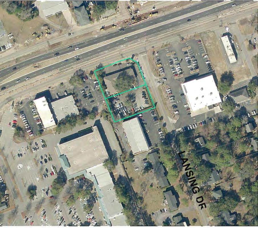
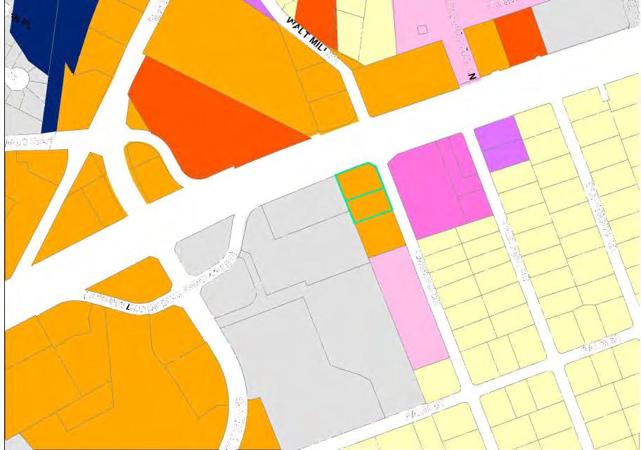
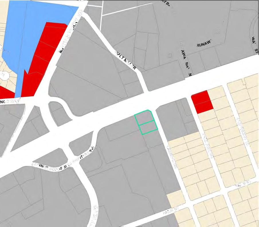
25 DRAFT MINUTES Planning Commission March 19, 2014 Page 5 of 16 automotive uses were rezoned to AB-2 upon that district s inception in However, for whatever reason, this property was not rezoned to the new AB-2 District classification. PROPOSAL Request is to rezone the property from AB to AB-2 to eliminate the non-conforming use status of the property as an automobile repair facility and allow an application for Special Exception approval for the addition of another repair bay. STAFF COMMENTS 1. As mentioned, the current Comprehensive Plan Future Land Use Map recommends UC- OD, Urban Corridor Overlay District land use which allows commercial land use. 2. The AB-2, Areawide Business 2 District zoning classification is compatible with the land use recommendation and the current use of the property. 3. The rezoning will remove the non-conforming status of the current use and will allow an application to expand the existing automobile repair facility under Special Exception approval from the Board of Zoning Appeals. RELATIONSHIP TO COMPREHENSIVE PLAN The following list of applicable Comprehensive Plan goals and strategies is provided so that they may be considered along with this zoning request: o Encourage appropriate commercial development to increase the property tax base and minimize the tax burden on homeowners. o Encourage the location of workplaces and educational facilities in close proximity to concentrations of residential development to provide convenient access from home to work. o Encourage in-fill development where infrastructure already exists. Mr. Neal asked if the expansion plans are known. Ms. Cousino answered in the negative. Mr. Chapman asked if, as a nonconforming use, they can go to BOZA for a variance. Mr. Prause answered in the negative and stated that the current use is not allowed by the zoning. Mr. Collins asked what uses are allowed in AB-2. Ms. Cousino answered that the main difference would be outdoor storage use that would be allowed by special exception. Mr. Neal stated that a BOZA approval would be required. Mr. Mark Rhodes, applicant, reviewed the request with the Commission. He stated that the intent is to expand the building to better serve their customers. Ms. Tina Garrett, 923 Lansing, expressed concern with the increased traffic on Lansing Drive and the impact to the residential neighborhood. She expressed concern with the on-street parking of the cars being serviced by Exclusively Bimmers. Mr. Matt Maurer, 927 Lansing Drive, expressed concern with the cut-through traffic of commercial vehicles and noted the neighborhood has been working with the Transportation Department. He expressed concern with the increased traffic impacts to Lansing Drive and suggested that the Transportation Department be consulted to deter additional traffic on Lansing Drive. Mr. Neal closed the public hearing. Mr. Rhodes understands the concerns on the amount of traffic and stated that they have been good neighbors and worked with the neighborhood. He stated that there is additional traffic from the
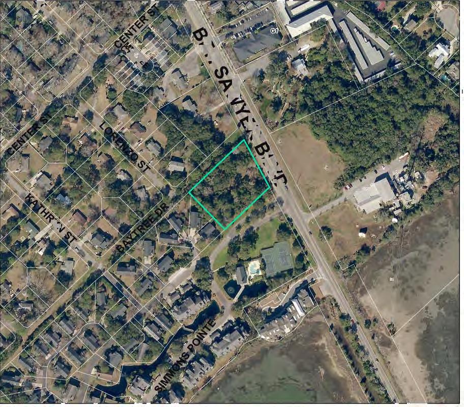
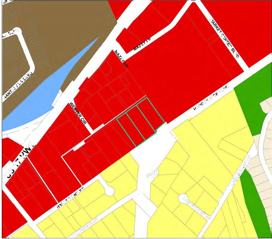
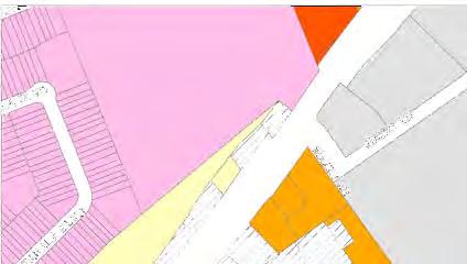
26 DRAFT MINUTES Planning Commission March 19, 2014 Page 6 of 16 surrounding commercial uses. He stated that the expansion desired is to serve their existing customers and not bring in new customers. Mr. Neal stated that the request is to bring the property to conformity with the zoning. Ms. Cousino responded in the affirmative. Mr. Neal asked if the BOZA would approve the special exception use for the property. Ms. Cousino answered in the affirmative and stated that any exterior changes would require design review approval as well. Mr. Neal asked if BOZA could place transportation stipulations. Ms. Cousino answered in the affirmative. Mr. Richardson moved for approval. Mr. Collins seconded the motion. Mr. Chapman stated that he is not in favor of the request based on the uses that would be allowed and the proximity to residential uses. Mr. Brimmer asked if there is a difference in allowed uses for AB and AB-2 within the Urban Corridor. Ms. Cousino answered that the uses for AB and AB-2 are similar with exception of outdoor storage and automotive uses, which are not allowed in AB. Mr. Chapman stated that a gas station could be built. Ms. Cousino answered that it would be allowed in AB as a special exception and in AB-2 as a conditional use, which would be a staff-level approval. Mr. Collins asked the zoning for Trader Joes. Ms. Cousino answered that it is zoned NC, Neighborhood Commercial. Mr. Collins asked about the Walgreens being constructed. Ms. Cousino answered that it is part of a Planned Development District. Ms. Richter-Lehrman stated that the impact to the surrounding residential neighborhood should be considered. She suggested that this should be addressed during their discussions during the Comprehensive Plan updates. Mr. Neal called for a vote on the motion. Motion passed on a 5 to 3 vote, with Ms. Richter-Lehrman, Mr. Chapman, and Mr. Collins opposed. C. COMPREHENSIVE PLAN AMENDMENT REQUEST; ZONING REQUEST PUBLIC HEARING: Request to amend the Town of Mount Pleasant Comprehensive Plan by changing the Future Land Use Map designation of the three parcels described below from Commercial to High Density Neighborhood. Also request to zone RTH, Townhouse For Sale Residential District, three parcels of land comprising approximately 2.92 acres, located off of Weaver Circle and Hungryneck Boulevard, and described as follows: (1) an approximately 0.92 acre parcel of land known as Lot 23, Smithville subdivision, and identified by TMS No ; (2) an approximately 1.06 acre parcel of land known as Lot 22, Smithville subdivision, and identified by TMS No ; and (3) an approximately 0.94 acre parcel of land known as Lot 21, Smithville subdivision, and identified by TMS No Ms. Cousino reviewed staff comments as follows: PROPERTY DESCRIPTION The subject property includes three parcels, comprising a total of 2.92 acres. The subject parcels are currently unincorporated and zoned R-4, Single-Family Residential District in Charleston
27 DRAFT MINUTES Planning Commission March 19, 2014 Page 7 of 16 County. Townhouses are a special exception use in the R-4 District and so must be approved by the Charleston County Board of Zoning Appeals. Conditions include architectural design standards and a limit of two attached dwelling units per structure. Legal access to the property is provided via Weaver Circle, a 10-foot unimproved right-of-way accessed from Hwy 17N. The parcels are bounded on the northeast by Lowe s, zoned PD, Planned Development District; on the south/southeast by the Hungryneck Boulevard right-ofway; on the west/southwest by an undeveloped parcel, also zoned R-4 in Charleston County; and on the northwest by detached single-family homes, also zoned R-4 in Charleston County. PROPOSAL The current request is to annex the property, amend the Comprehensive Plan Future Land Use Map, and zone the property RTH, Residential Townhouse For Sale District. RELATIONSHIP TO COMPREHENSIVE PLAN The Comprehensive Plan Future Land Use Map recommends Commercial land uses for the subject parcels. The applicant has requested to change the designation to High Density Neighborhood, which provides for a maximum density of 9 units per acre. For this 2.92 acre tract, this yields a maximum of 26 dwelling units. The following list of applicable Comprehensive Plan goals and strategies is provided so that they may be considered along with this zoning request: o Provide a mix of housing types in a variety of price ranges, including rental housing options, to meet the needs of the wide range of Town residents and workforce and to promote Mount Pleasant as a lifelong community. o Denser development should occur closer to the US 17 corridor where there is greater transportation infrastructure. o Encourage appropriate commercial development to increase the property tax base and minimize the tax burden on homeowners. o Encourage the location of workplaces and educational facilities in close proximity to concentrations of residential development to provide convenient access from home to work. STAFF COMMENTS 1. This request represents a departure from the Comprehensive Plan Future Land Use designation which has been in effect since The Comprehensive Plan endeavors to balance the amount and location of commercial uses with residential uses town-wide and in neighborhood areas. 2. While applications should always be viewed in their own context and based upon the merits of the request, appropriate care should be given in recommending changes from commercial zoning to residential zoning as well as commercial land use to residential land use as Planning staff has recently had various identical inquiries in different locations. 3. The Town s Transportation Department Director has indicated that direct access to Hungryneck Boulevard would not be granted due to the current configuration of the rightof-way in relation to the subject property. There is an existing driveway providing sole access to TMS No and an entrance into a development on the subject parcels would not meet spacing requirements from this driveway. This means that the only access to the proposed development will be via Weaver Circle. 4. If approved, a Sketch Plan and Preliminary Plat would follow before construction could commence. Mr. Siegrist asked about the access for the homes behind the subject property. Ms. Cousino answered that it is from Weaver Circle. She stated that she is not aware of any legal proceedings as previously indicated by Ms. Richardson during the public comment period.
28 DRAFT MINUTES Planning Commission March 19, 2014 Page 8 of 16 Mr. Richardson asked about the existing access drive and if it is in the Hungryneck Boulevard rightof-way. Ms. Cousino answered in the affirmative and indicated the location on the map for the Commission. Mr. Chris Hill, applicant, reviewed the request with the Commission. He stated that he was recently made aware of litigation regarding a portion of Weaver Circle being a private drive. He stated that he is working with the Transportation Department to determine if access to Hungryneck Boulevard can be achieved. He stated that commercial uses do not appear to be viable and suggested that residential development would be the best fit for the property. Mr. Collins asked about the State Farm building. Mr. Hill indicated the location on the map for the Commission and stated that it is accessed from Mazzy Lane. Mr. Edward Cummings, Jr., 1119 Weaver Circle, expressed concern with his property being impacted and dwindling due to construction of Hungryneck Boulevard. He expressed concern with additional traffic in the area and the additional impact on Weaver Circle. He suggested that more townhomes will cause increased traffic in the area. He suggested that there should not be any further residential construction in this area due to the current infrastructure. Mr. Clayton Oree, 1113 Weaver Circle, expressed concern about traffic in the area and being able to access US17 from Weaver Circle. He stated that during the summer the traffic is worse than it is currently. He suggested that the concerns and desires of the existing residents should be considered before additional construction is approved. Ms. Richardson clarified the location of the private easement that was granted to the Snipes through court litigation. Mr. Neal closed the public hearing. Mr. Hill stated that the traffic study shows that only cars would possibly be using Weaver Circle during peak hours. Mr. Neal asked if Mr. Hill has contacted any of the neighbors regarding this project. Mr. Hill answered in the negative. He stated that he has spoken with a group that included some of the homeowners and others were family or friends. Mr. Richardson asked about access to the property. Mr. Hill answered that if the development is not allowed by the surrounding neighbors to use Weaver Circle and not allowed by the Town to use Hungryneck Boulevard, then he would not have access to the property. Mr. Chapman asked if control access was bought by the Town. Mr. Pagliarini answered that access was not an issue during the condemnation proceedings for the adjacent property. He stated that the intent would not be able to be determined at this time. Mr. Collins asked if a certain number of curb cuts are allowed on a roadway. Ms. Cousino answered that she was not sure about a maximum number of curb cuts that are allowed, but there is a driveway separation requirement, as well as sight distance requirements.
29 Mr. Richardson moved for denial of the request. Mr. Chapman seconded the motion. DRAFT MINUTES Planning Commission March 19, 2014 Page 9 of 16 Mr. Richardson suggested that this was not a proper way to deal with this property and access should be definitively determined before moving forward. Mr. Neal commended the developer for moving forward with annexation. He stated that contacting the surrounding neighbors is often a vital aspect. Mr. Neal called for a vote on the motion. All in favor. D. PRELIMINARY PLAT APPROVAL REQUEST: Request approval of preliminary plat for Carolina Park, Phase 5C, 68 detached single-family lots zoned PD, Planned Development District, to be located on Banning Street, Crosstrees Lane, and Wilkes Way on an approximately acre tract of land identified by TMS Nos and Mr. Mitchell reviewed staff comments as follows: HISTORY The property is part of the Carolina Park PD which received approval for its current zoning on September 13, A sketch plan was approved on April 17, PROPERTY DESCRIPTION The property is approximately acres, including 6.53 acres of freshwater wetlands. It is accessible from Carolina Park Boulevard via Banning Street. PROPOSAL The current request is to receive Preliminary Plat approval for sixty eight (68) detached single family residential lots. The street and drainage system is planned to be dedicated to the Town upon completion. Ponds will be privately owned and maintained by the HOA. Proposal also includes a request for approval of the road names Crosstrees Lane and Wilkes Way. STAFF COMMENTS 1. Preliminary Plat substantially conforms to approved sketch plan. 2. As the CPR district continues to develop, particularly the further development of Banning Street, Planning Commission will need to ensure that the connection is made with Coastal Crab Lane in Darrell Creek. As additional phases become approved and built, the collector road will become more difficult to adjust for this connection. Mr. Chapman asked how interconnectivity is ensured. Mr. Mitchell answered that it is included in the Darrell Creek Master Plan. He stated that the connection would be reviewed during sketch plan approval. Mr. Collins asked where Banning Street ends. Mr. Mitchell indicated the location on the map. Mr. Brian Keels, representative for Carolina Park, reviewed the future connection of Coastal Crab Drive with Banning Street and stated that it would be accomplished with the next two phases. Mr. Chapman expressed concern with ensuring that the connection is completed. Mr. Keels stated that they are amenable to having the interconnectivity. Mr. Neal asked which phase would have the interconnectivity. Mr. Keels answered that it would be several years.
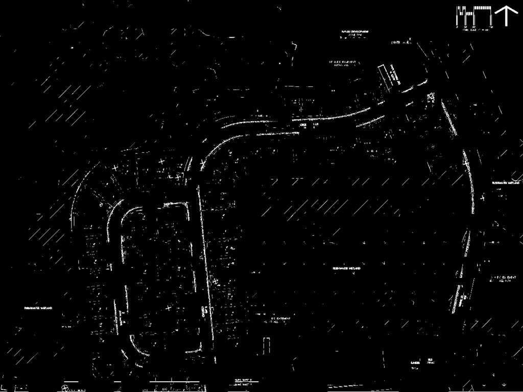
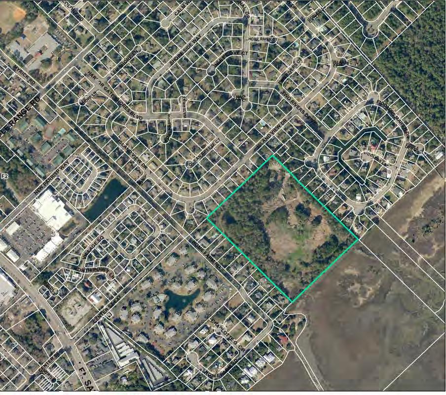
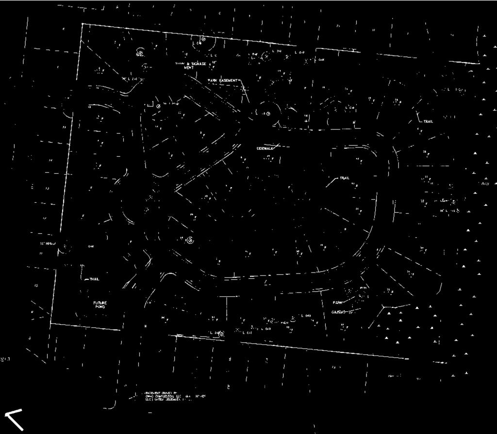
30 DRAFT MINUTES Planning Commission March 19, 2014 Page 10 of 16 Ms. Sarah Moore, SeamonWhiteside, stated that Banning Street goes through a wetland so the Army Corps of Engineers has dictated the alignment of Banning Street through Phase 5C. She stated that the connection is currently shown in the proposed Phase 7 that will be coming for approval in the near future. She stated that the development agreement would have to be amended in order to allow that interconnectivity. Mr. Chapman moved for approval of the request including all staff comments and with the extension of Banning Street to Coastal Crab Drive. Mr. Richardson seconded the motion. All in favor. E. PRELIMINARY PLAT APPROVAL REQUEST: Request approval of preliminary plat for Dunes West, The Harbour, Phase 11D, 29 detached single-family lots zoned PD, Planned Development District, to be located on Logbrook Lane, Weather Helm Drive, and Quarterdeck Court on an approximately 7.62 acre portion of an approximately acre parcel of land identified by TMS No Mr. Mitchell reviewed staff comments as follows: HISTORY Planning Commission approved the Sketch Plan for The Harbour Phase 11A and 11B on January 20, Following a favorable review, Phase 11B and 11A were divided into additional Phases of 11C and 11D. PROPERTY DESCRIPTION Property is currently undeveloped. PROPOSAL Current request is approval to plat and record twenty-nine (29) single family lots following the installation of infrastructure. Request also includes approval of the road name Quarterdeck Court. STAFF COMMENTS 1. The Preliminary Plat conforms to the approved Sketch Plan in Rear alley ways were removed. Applicant is requesting these lots be front loaded. 2. A sidewalk was added to Weather Helm Drive and will connect to the sidewalk along Ayers Plantation Way. 3. Phase 8 and 10 are the only remaining phases that have not received Sketch Plan and Preliminary Plat approvals. Mr. Chapman commended the engineer for the inclusion of sidewalks. Mr. Richardson moved for approval including all staff comments. Mr. Siegrist seconded the motion. All in favor. F. Hindman SKETCH PLAN APPROVAL REQUEST: Request approval of sketch plan for Hindman Subdivision, 54 detached single-family residential lots zoned R-2, Low Density Residential District, to be located adjacent to the Harborgate Shores and Home Farm subdivisions on an approximately acre parcel of land identified by TMS No Ms. Cousino stated that a request for deferral was received from the applicant. Mr. Chapman moved for deferral. Mr. Richardson seconded the motion. All in favor.
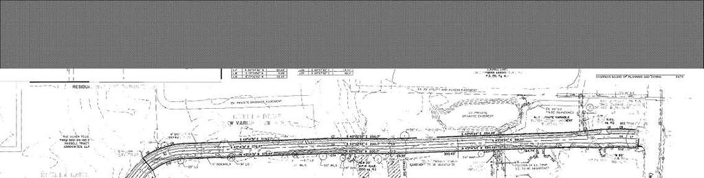
31 DRAFT MINUTES Planning Commission March 19, 2014 Page 11 of 16 G. PRELIMINARY PLAT APPROVAL REQUEST: Request approval of preliminary plat for a Phase 2 of the Primary Connector Road in the Central Mount Pleasant Planned Development District, to be known as Rivella Drive, located between Midtown Avenue and Rifle Range Road, and located on a portion of TMS No Mr. Mitchell reviewed staff comments as follows: HISTORY Subject parcel is part of the Central Mount Pleasant Development Agreement adopted by ordinance on May 17, The Development Agreement was amended on Dec 12, 2012 with a revised Sketch Plan. The road is a primary collector and serves as an important vehicular link between Rifle Range Road and Midtown Avenue. It is an integral part of the development plan. The May 2007 DA required the roadway to be completed within three years of completion of Hungryneck Boulevard Phase 2B, with a one (1) year extension allowance. The 2012 DA Amendment clarified that the completion date of Hungryneck Phase 2B was August 31, 2010 and did not change the one (1) year extension allowance. This is the second section proposed for construction. At the end of this month, the developer will have five (5) months remaining to complete the roadway connection with Rifle Range Road as specified in the DA of PROPOSAL Applicant is proposing to construct nearly 2000 LF of roadway to Rifle Range Road. STAFF COMMENTS 1. The alignment conforms to the Sketch Plan alignment and satisfies the multi-modal use. 2. Recommend providing a geo-technical study and pavement design for the roadway section. 3. Sept 2013 Drainage Report was modified to separate outfall channels between nodes CMP LL (DN8) to DN9. The change was not noted within the report. It separates the outfall channel from Laurel Lakes creating two parallel outfalls. This outfall was originally intended to be shared and improved for Laurel Lakes and CMP. Staff does not recommend this change to create two outfall channels. It unnecessarily increases the maintenance responsibility for the Town and avoids improving an existing system. It is recommended to keep the design consistent with the 2013 drainage scheme. 4. Other engineering comments may be made pending final review by Town Transportation Dept. Mr. Mitchell stated that the Transportation Department will request a warrant study to determine if a traffic signal is needed at Rifle Range Road as indicated in the development agreement. Mr. Neal expressed concern with the traffic speed on the roadway and asked if there would be any traffic calming. Mr. Jimmy DuPre, Thomas & Hutton, reviewed the approved road cross-section with the Commission and stated that there would be bump outs where on-street parking would be allowed. Mr. Neal asked if there would be brick pavers for the crosswalks. Mr. DuPre answered that there would be crosswalk designations. Mr. Chapman stated that the recommendation was to have the signal installed prior to the roadway being constructed. Mr. DuPre answered that the signal would be installed once warranted. Mr. Mitchell stated that this is consistent with the development agreement. Mr. Collins asked where the traffic signal is located near Whitesides Elementary. Mr. DuPre answered that the proposed roadway would be directly across from Whitesides Elementary.
32 DRAFT MINUTES Planning Commission March 19, 2014 Page 12 of 16 Mr. Brimmer asked about drainage. Mr. DuPre answered that they are working with staff. Mr. Richardson moved for approval including all staff comments and comments regarding the traffic signal. Mr. Collins seconded the motion. All in favor. H. Sketch Plan Tupelo Row SKETCH PLAN APPROVAL REQUEST: Request approval of sketch plan for Tupelo Row, 26 detached single-family lots zoned PD, Planned Development District, to be located off of Tupelo Forest Drive on an approximately acre portion of an approximately 35.8 acre parcel of land identified by TMS No Mr. Mitchell reviewed staff comments as follows: HISTORY Tupelo Row is located in the Pepper Tract PD which received zoning on July 12, PROPERTY DESCRIPTION The property contains approximately 35 acres accessed from Tupelo Forest Drive. Project area contains high ground and freshwater wetlands. PROPOSAL The current request is for sketch plan approval of twenty six (26) clustered single family residential lots. Proposal also includes two proposed public right of ways, and one (1) stormwater detention pond. STAFF COMMENTS 1. Conforms to intended land use The request complies with the approved land use plan for the Pepper Tract. 2. Lot layout Tupelo Row is a cluster design development with an average lot size just over 5,000sf. The roads and lots are designed to provide for future interconnectivity and continued development (labeled on the plans as Phase 2). The roadway connection with Darrell Creek Trail is shown in the Land Use Plan for the Pepper Tract. The road classification is not mentioned in the Planned Development Ordinance and the alignment shall conform as future phases are developed. 3. Street/sidewalk designs Streets provide for future interconnectivity and include temporary turnarounds. The Pepper Tract PD only requires a sidewalk on one side of the street within the cluster development area. Sidewalks are provided on both sides of the street where adjacent to residential lots. It is recommended to design the temporary turn-around with a diameter that meets the cul de sac standards in the LDR. 4. Open space A master plan for the trail system was approved in April 2013, however it only includes phases 1 4 and not Tupelo Row. Because it is anticipated that Tupelo Row Dr. will connect to Darrell Creek Trail in the future, the concrete path shown along Tupelo Forest Drive on the trail system plan should continue down one side of Tupelo Row Dr. instead of just the proposed sidewalk. The Pepper Tract zoning plan also shows a pedestrian trail system located within the wetlands adjacent to Tupelo Row Drive, but they are not shown on the sketch plan and need to be included. HOA space is not labeled and not identified as public or private space. 5. SW detention The stormwater detention pond is behind lots and does not provide a visible amenity from the road. It is encouraged to locate ponds where they have more visibility and treated as an amenity to the subdivision. A pedestrian trail loops around the pond and connects to both main roads. 6. Buffers/landscaping Buffers are provided adjacent to the wetlands. No buffers are required for adjacent residential properties.
33 DRAFT MINUTES Planning Commission March 19, 2014 Page 13 of Sketch Plan Checklist Checklist items are complete. Mr. Neal asked if the applicant has addressed all staff comments. Mr. Mitchell answered in the affirmative. Mr. Chapman asked how interconnectivity to Darrell Creek Trail is ensured. Mr. Mitchell answered that it would be through the roadway design and alignment. He stated that it is not required by the planned development ordinance, but the developer is working with the adjacent property owners to have access. Mr. Tim Cook, applicant, reviewed the request with the Commission. He stated that he is working with the adjacent property owners and the Transportation Department to have future interconnectivity. Mr. Neal asked who would be the developer. Mr. Cook answered that it is not known at this time as he is in discussions with several developers. Mr. Brimmer asked if the number of lots changed when staff comments were incorporated into the sketch plan. Mr. Cook answered in the affirmative and stated that the pond location was changed per staff recommendation. Ms. Cousino stated that they are within the maximum number of lots allowed. Mr. Brimmer asked about sidewalks and why the dual sidewalk did not extend to the entrance roadway. Mr. Cook answered that it is a significant expense. Mr. Collins moved for approval including staff comments. Ms. Richter-Lehrman seconded the motion. All in favor. I. SKETCH PLAN APPROVAL REQUEST: Request approval of sketch plan for the reconfiguration of six parcels of land zoned R-1, Low Density Residential District, comprising approximately 3.2 acres, located in Scanlonville on Third Avenue and Second Street, and identified by TMS Nos , , , , , This request also includes a request for an exception from Land Development Regulations Section (C) (1). Mr. Mitchell reviewed staff comments as follows: HISTORY Five of the seven lots within the development boundary are from the original 1870 subdivision plat of Remley s Point. In 2009 an adjoining property line between lots 65 and 74 was abandoned and a new lot established with an access easement. On January 22, 2014, Planning Commission denied current sketch plan proposal. Reasons for denial included incomplete critical line certification, questionable protected boundary of the cemetery, concerns over buildable area, and the ability to meet stormwater requirements. The application addressed all comments except the buildable area concern. The applicant will address this concern prior to the meeting. PROPERTY DESCRIPTION Subject parcels are currently undeveloped with limited access. Three of the seven lots have frontage on a public street. The lots are heavily wooded with a number of oaks. Most trees are smaller than 16 Inches DBH and not required to be shown on the sketch plan. The property naturally slopes towards the critical area. There is a cemetery on-site. PROPOSAL

 buildable lots. The project includes seven (7) recorded lots, two of which have a significant amount of marsh area that severely impacts the buildable area.")

34 DRAFT MINUTES Planning Commission March 19, 2014 Page 14 of 16 Current request is to configure the existing lot arrangement into lots accessible from an access easement connecting from Third Avenue to Second Street. STAFF COMMENTS 1. Conforms to intended land use Lots are zoned R-1 and meet the minimum lot dimensional requirements. 2. Lot layout Topographic constraints and accessibility significantly restrict the design layout. The buildable area is questionable due to a number of significant trees. The proposal is to create seven (7) buildable lots. The project includes seven (7) recorded lots, two of which have a significant amount of marsh area that severely impacts the buildable area. Per LDR Section , Blocks and Lots, the Planning Commission has the authority to allow adjustments as necessary, citing unavoidable hardships. There are two standards within the Land Development Regulations that the Planning Commission should take under consideration during its review. The first, to allow the subdivision and creation of lots from an access easement, and the second, to ensure the lots conform to the neighborhood street and block design or layout as it relates to size and shape of the new lots. A grid pattern is the lot arrangement within Remleys Point and lot sizes are a consistent 100 x 200 feet. See Exhibit 1 below for block layout design and Exhibit 2 for proposed lot arrangement. Exhibit 1 Exhibit 2 3. Street/sidewalk design The access easement is to be privately maintained by the HOA. It is not intended to be within a separate HOA parcel. The roadway is to meet the minimum standards for Emergency and Fire response vehicles. There are no existing or future plans for sidewalks on either public street. Therefore, installation of a new sidewalk is not recommended with this development. Below is an aerial showing the marsh in relation to the existing lot layout. The dashed red line depicts the easement alignment with the current lot arrangement. Three (3) of the five (5) lots along the marsh can be accessible through an easement without a subdivision. The two lots along 3rd Avenue have adequate frontage for access. Aerial below is the area at a larger scale showing block design. There are other lots originally platted within Remleys Point that are not capable of development due to their location within the saltwater marsh.

35 DRAFT MINUTES Planning Commission March 19, 2014 Page 15 of Open space Open Space is required to be 0.1 acre (4350 sq ft). The amount proposed is 5400 sq ft of high ground located in the southeast corner. The area is to be accessible by a pedestrian easement. 5. SW detention Water quality standards are to comply with State and Town Water Quality Chapter 153. Applicant is proposing swales with sediment filters along adjoining property lines. Calculations and design specifications are to be required during the Preliminary Plat review. 6. Buffers/landscaping There is to be a critical line buffer and thirty (30) foot impervious surface setback along the critical line. The locations of significant and historic trees are shown without the protective zones. These lots are heavily wooded with many significant trees. Staff recommends the applicant show buildable areas outside protective zones for historic trees (>24 inch DBH) and the location of trees significant in size (> 16in DBH) to be removed with a mitigation plan. The applicant intends to address the buildable area and tree conflicts prior to the meeting. 7. Sketch Plan Checklist Checklist items are complete. Mr. Neal left at this time (7:00 p.m.) and turned the meeting over to Mr. Richardson as vice-chair. Mr. Richardson asked about the rear setbacks. Mr. Mitchell answered that the rear setback, as well as the critical line setback, is 30 feet. He stated that the rear setback is measured from the property line, while the critical line setback is measured from the critical line. Mr. Richardson asked about the buffer around the cemetery. Mr. Mitchell answered that it would be required and the buffer would be required 15 feet from the grave site. Mr. Brimmer asked about the easement. Mr. Mitchell answered that there have been access easements on private property. Ms. Cousino answered that there would be deed restrictions creating the easements. Mr. Brimmer asked about liability issues. Mr. Pagliarini answered that the HOA would be liable, but it would depend on how the deed restriction is structured. Mr. Brimmer asked how the construction of the easement would be monitored and inspected. Mr. Mitchell answered that the roadway would be geo-technically inspected to ensure it is constructed to allow emergency vehicle access. Mr. Siegrist asked what the exception is for. Mr. Mitchell answered that it is to allow subdivision of lots off of an access easement. Mr. Brimmer asked if the cemetery would be maintained by the Town. Mr. Pagliarini answered that there are state statutes regarding maintenance of historic sites. Mr. Brimmer asked who would be responsible for maintenance. Mr. Pagliarini answered that it would again depend on the structure of the agreement.
36 DRAFT MINUTES Planning Commission March 19, 2014 Page 16 of 16 Mr. Chapman asked if the critical line has been certified. Mr. Mitchell answered in the affirmative and stated that it was certified in Mr. Mickey Seabrook, applicant, reviewed the request with the Commission. Mr. Al McNeil, developer, stated that the cemetery and the access easement would be maintained by the HOA. Mr. Richardson asked about accessory structure setbacks. Mr. Mitchell answered that there is a 6 foot setback for accessory structures. Mr. Richardson asked where front setback would be located. Mr. Mitchell answered that shorter property line is typically determined to be the front and rear property line. Ms. Cousino answered that there are no regulations regarding orientation of the house. She stated that the lots meet the Town requirements. Mr. Chapman asked what exceptions need to be approved. Mr. Mitchell answered that it is to subdivide lots from access easement and deviation from typical lot layout within Remley s Point. Mr. Chapman asked the dimensions of the large adjacent lots. Mr. Mitchell answered that it is the River Reach subdivision, and the lots are not larger than the Remley s Point lots. Mr. Chapman moved for denial based on the fact that the request proposes a deviation in lot size. Mr. Brimmer seconded the motion. Motion passed on a 4 to 3 vote, with Mr. Bryson, Mr. Collins, and Mr. Richardson opposed. There being no further business, the meeting adjourned at 7:36 p.m. Submitted by, L. Lynes PlanComsn
37 19 March 2014
38 4. Unfinished Business a. COMPREHENSIVE PLAN AMENDMENT REQUEST; REZONING REQUEST PUBLIC HEARING: Request to amend the Town of Mount Pleasant Comprehensive Plan by changing the Future Land Use Map designation from Urban Corridor to High Density Neighborhood for an approximately 1.31 acre parcel of land known as Tract 1, located at 1543 Ben Sawyer Boulevard, and identified by TMS No Also request to rezone the aforementioned parcel from AB, Areawide Business District, and UC-CBS, Coleman Boulevard-Ben Sawyer Boulevard Urban Corridor Overlay District, to PD, Planned Development District.
39


40


41

42
43 5. Requests a. PRELIMINARY PLAT APPROVAL REQUEST: Request approval of preliminary plat for Old Georgetown Subdivision, a development containing 31 detached single-family residential lots zoned PD-CD, Planned Development Conservation Design District, to be located on an approximately acre parcel of land, known as Lot 8, Seashore subdivision, located on Old Georgetown Road approximately 250 feet northeast of its intersection with Children Road, and identified by TMS No


44

45
46
47 5. Requests b. REZONING REQUEST PUBLIC HEARING: Request to rezone from AB, Areawide Business District, to AB-2, Areawide Business-2 District, two parcels of land comprising approximately 0.89 acres, located at 900 Lansing Drive; one parcel comprising approximately 0.48 acres, known as Part Lot 9, Block P, The Groves subdivision, and identified by TMS No ; the other parcel comprising approximately 0.41 acres, known as Lot 8, Block P, The Groves subdivision, and identified by TMS No

48


49
50
51 5. Requests c. COMPREHENSIVE PLAN AMENDMENT REQUEST; ZONING REQUEST PUBLIC HEARING: Request to amend the Town of Mount Pleasant Comprehensive Plan by changing the Future Land Use Map designation of the three parcels described below from Commercial to High Density Neighborhood. Also request to zone RTH, Townhouse For Sale Residential District, three parcels of land comprising approximately 2.92 acres, located off of Weaver Circle and Hungryneck Boulevard, and described as follows: (1) an approximately 0.92 acre parcel of land known as Lot 23, Smithville subdivision, and identified by TMS No ; (2) an approximately 1.06 acre parcel of land known as Lot 22, Smithville subdivision, and identified by TMS No ; and (3) an approximately 0.94 acre parcel of land known as Lot 21, Smithville subdivision, and identified by TMS No
52


53
54
55 5. Requests d. PRELIMINARY PLAT APPROVAL REQUEST: Request approval of preliminary plat for Carolina Park, Phase 5C, 68 detached single-family lots zoned PD, Planned Development District, to be located on Banning Street, Crosstrees Lane, and Wilkes Way on an approximately acre tract of land identified by TMS Nos and
56

57

58
59 5. Requests e. PRELIMINARY PLAT APPROVAL REQUEST: Request approval of preliminary plat for Dunes West, The Harbour, Phase 11D, 29 detached single-family lots zoned PD, Planned Development District, to be located on Logbrook Lane, Weather Helm Drive, and Quarterdeck Court on an approximately 7.62 acre portion of an approximately acre parcel of land identified by TMS No

60

61

62
63 5. Requests f. SKETCH PLAN APPROVAL REQUEST: Request approval of sketch plan for Hindman Subdivision, 54 detached single-family residential lots zoned R-2, Low Density Residential District, to be located adjacent to the Harborgate Shores and Home Farm subdivisions on an approximately acre parcel of land identified by TMS No
64
65
66 5. Requests g. PRELIMINARY PLAT APPROVAL REQUEST: Request approval of preliminary plat for a Phase 2 of the Primary Connector Road in the Central Mount Pleasant Planned Development District, to be known as Rivella Drive, located between Midtown Avenue and Rifle Range Road, and located on a portion of TMS No

67


68
69
70 5. Requests h. SKETCH PLAN APPROVAL REQUEST: Request approval of sketch plan for Tupelo Row, 26 detached single-family lots zoned PD, Planned Development District, to be located off of Tupelo Forest Drive on an approximately acre portion of an approximately 35.8 acre parcel of land identified by TMS No
71

72 Sketch Plan, as submitted

73 Sketch Plan, revised to address staff comments
74
75 5. Requests i. SKETCH PLAN APPROVAL REQUEST: Request approval of sketch plan for the reconfiguration of six parcels of land zoned R-1, Low Density Residential District, comprising approximately 3.2 acres, located in Scanlonville on Third Avenue and Second Street, and identified by TMS Nos , , , , , This request also includes a request for an exception from Land Development Regulations Section (C) (1).
76
77
78

79


80 19 March 2014
81 1 of 2 2/24/ :30 AM Planning Commission Application ALL APPLICATIONS ARE DUE BY 11:59 p.m. ON THE DEADLINE DATES. It is highly recommended that the property owner and/or their representative meet with staff prior to submitting an application. Nature of Request & Fees Check all that apply:* Rezoning Planned Development Amendment Comprehensive Plan Amendment Impact Assessment & Conceptual Plan Sketch Plan Preliminary Plat Other Fee Schedule: For areas greater than acres the fee is $400 + $2 per additional acre. Please select the appropriate fee below and if over acres please enter acreage amount over acres in the quantity field below:* 0-5 Acres - $ acres Quantity (total acreage - 100)= Requirements All supplemental information must be scaled to 8 ½ x 11 sheets and submitted in a portable digital format (pdf) with this application and appropriate fee. The following supplemental information is included with this application(please list):* Subject Property / Properties Information TMS #:* Address:* Owner:* Present Use of Property:* Request:* Acreage / Sq. Feet:* Comprehensive Plan Amendment (only fill out if Comprehensive Plan Amendment requested) Present Comprehensive Plan Land Use Designation: Proposed Comprehensive Plan Land Use Designation: Description of Proposed Structure and Use of Property: Applicant Information Name:* Address:* Phone:* Please attach supplemental information outlined above: No file selected. * Convert to PDF? (GIF, JPG, JPEG, PNG, DOC, DOCX, XLS, XLSX, TXT)
82 2 of 2 2/24/ :30 AM I, the undersigned, serve as the owner or owner's representative and certify the information contained herein to be true and accurate. If an application is found to be incomplete, the primary contact will be notified and the application will be removed from the agenda. I further certify that the tract(s) or parcel(s) of land to which this approval request pertains: * is restricted is not restricted by any recorded covenant that is contrary to, conflicts with, or prohibits the activity for which approval is sought as provided in SC Code of Laws Section , and the Town of Mount Pleasant Code of Ordinances and I agree that all terms and information are true to my knowledge:* I agree Information of person completing electronic signature: Name:* Address (if different from above): (if different from above): Phone (if different from above): * indicates required fields.

83

84

85
86 1 of 2 2/24/2014 1:56 PM Planning Commission Application ALL APPLICATIONS ARE DUE BY 11:59 p.m. ON THE DEADLINE DATES. It is highly recommended that the property owner and/or their representative meet with staff prior to submitting an application. Nature of Request & Fees Check all that apply:* Rezoning Planned Development Amendment Comprehensive Plan Amendment Impact Assessment & Conceptual Plan Sketch Plan Preliminary Plat Other Fee Schedule: For areas greater than acres the fee is $400 + $2 per additional acre. Please select the appropriate fee below and if over acres please enter acreage amount over acres in the quantity field below:* 0-5 Acres - $ acres Quantity (total acreage - 100)= Requirements All supplemental information must be scaled to 8 ½ x 11 sheets and submitted in a portable digital format (pdf) with this application and appropriate fee. The following supplemental information is included with this application(please list):* Subject Property / Properties Information TMS #:* Address:* Owner:* Acreage / Sq. Feet:* Present Use of Property:* Request:* Comprehensive Plan Amendment (only fill out if Comprehensive Plan Amendment requested) Present Comprehensive Plan Land Use Designation: Proposed Comprehensive Plan Land Use Designation: Description of Proposed Structure and Use of Property: Applicant Information Name:* Address:* Phone:* *
87 2 of 2 2/24/2014 1:56 PM Please attach supplemental information outlined above: No file selected. Convert to PDF? (GIF, JPG, JPEG, PNG, DOC, DOCX, XLS, XLSX, TXT) I, the undersigned, serve as the owner or owner's representative and certify the information contained herein to be true and accurate. If an application is found to be incomplete, the primary contact will be notified and the application will be removed from the agenda. I further certify that the tract(s) or parcel(s) of land to which this approval request pertains: * is restricted is not restricted by any recorded covenant that is contrary to, conflicts with, or prohibits the activity for which approval is sought as provided in SC Code of Laws Section , and the Town of Mount Pleasant Code of Ordinances and I agree that all terms and information are true to my knowledge:* I agree Information of person completing electronic signature: Name:* Address (if different from above): (if different from above): Phone (if different from above): * indicates required fields.
88


89
90


91 Town of Mount Pleasant Traffic Impact Analysis Process Review/Update Prepared by May 6, 2013
92 Town of Mount Pleasant Traffic Impact Analysis Process Review/Update TABLE OF CONTENTS 1. Traffic Impact Analysis Process (TIAP) in System Performance Monitoring Roadway Network and Traffic Zones Historic Growth and Improvement Needs BCDCOG CHATS Zonal Data Residential and Commercial Development Traffic Impact Studies Improvement Programs and Plans Conclusion and Recommendations... 8 Appendix A Planned and Programmed Transportation Improvements i
93 Town of Mount Pleasant Traffic Impact Analysis Process Review/Update 1. TRAFFIC IMPACT ANALYSIS PROCESS (TIAP) IN SYSTEM PERFORMANCE MONITORING From the early 1990s through 2008, the Town of Mount Pleasant experienced aggressive growth. While the Town had been proactive in identifying the implications of growth on infrastructure, including the transportation system and roadway network, the intensity of growth was on the verge of outpacing the Town s ability to fund improvements and maintain acceptable levels of service (LOS). With regard to transportation infrastructure, the Town prepared and periodically updated a phased long range transportation plan that identified specific programs and projects needed to maintain acceptable LOS. The Town instituted an impact fee ordinance to assist in funding the improvements necessary to support development. The Traffic Impact Analysis Process (TIAP) was developed to facilitate ongoing review of transportation system loadings as developments occurred over time. Specifically, the QRS modeling process built into the TIAP enabled Town staff to assess the incremental and additive demands on the system. Some concurrence could thereby be maintained between the pace of growth and the ability of the Town and development community to implement improvements to the network in response to that growth. The Town works cooperatively with state, federal and regional partners to access a broad range of potential funding sources in responding to existing and future capacity, operational, and safety needs. These improvements are beyond those considered directly related to a particular development s ingress/egress. Similar to other services and infrastructure investments by the Town, the transportation system planning and improvement programs were linked with the development pace likely under the overall building permit application system. The purpose of this study was to determine the need for any modification or update to the current process for monitoring existing and assessing potential future traffic impacts related to growth and development in the Town of Mount Pleasant. Findings from this review will assist in determining whether the current process, procedures, guidelines and standards are still necessary, appropriate and reasonable for use by Town staff and Council. Subsequent sections of this technical report: Identify the traffic analysis zones and transportation network used in regional planning and programming efforts Present information underlying the transportation infrastructure planning, programming and monitoring activities in the Town of Mount Pleasant Review the adequacy of improvements identified to respond to needs 1
94 Town of Mount Pleasant Traffic Impact Analysis Process Review/Update Provide conclusions and recommendations regarding continuation of the TIAP, monitoring of development activities in relation to transportation system needs, and identification of projects in response to those needs. 2
.")
95 Town of Mount Pleasant Traffic Impact Analysis Process Review/Update 2. ROADWAY NETWORK AND TRAFFIC ZONES The initial data collection effort focused on data available from the Berkeley-Charleston- Dorchester Council of Governments (BCDCOG). The data supports transportation planning activities utilizing the regional travel demand model. The model consists of a collection of zones containing the region s socio-economic data (households and employment) and roadway infrastructure (capacity, travel time and volume). The travel demand model function is to conduct socio-economic growth forecasts for the zones, convert the data into trips, distribute the trips across the region, and assign the trips to the roadway infrastructure. The assignment of trips to the infrastructure in the model allows for future growth to be visualized as a function of level of service (LOS) on the specific roadways. The structure of the traffic analysis zones (TAZ) in the Town of Mount Pleasant area from the BCDCOG model is shown in the following figure. Traffic Analysis Zones (TAZ) from BCDCOG Model The figure below shows roadway volume to capacity (V/C) ratios from the BCDCOG model. The values shown are for the 2008 base year model. The roadway LOS is indicated by the color on the road: green and yellow roads have acceptable levels of service (A, B, C, or D) while orange and red roads have deficient levels of service (E and F). As the figure indicates, many Town roadways continue to offer available capacity, with the exception of Long Point Road and SC 41. 3
96 Town of Mount Pleasant Traffic Impact Analysis Process Review/Update Roadway Volume to Capacity (V/C) Ratios Deficient service levels on many of the segments on the network have been improved through recently completed, ongoing or programmed projects. Examples include the JDB widening, US 17 North widening, I-526/Hungry Neck Boulevard Interchange, Isle of Palms Connector widening, Isle of Palms Connector/Rifle Range Road intersection, and SC 41 widening. It should be noted that the Town has created a more detailed zonal structure for the Town network, which includes many more zones and differences in the zone boundaries as compared to the BCDCOG model. This more detailed network underlies the TIAP and the Town s own long range planning and programming activities. Development data as monitored by residential and commercial permits is maintained by Town staff to allow for more detailed assessment of current and future travel patterns related to existing and future development. 3. HISTORIC GROWTH AND IMPROVEMENT NEEDS Three key pieces of information for the Town of Mount Pleasant and surrounding portions of the metropolitan area have been reviewed and compared to gauge the extent to which development activity is accurately captured regardless of user (Town or BCDCOG). One of these the BCDCOG travel demand model is maintained by BCDCOG. The other two development permits and traffic impact studies are maintained by the Town. The reviews conducted as a part of this effort indicate that there is consistency between the three over time, primarily in the way data is inserted into the needs identification and project programming process. 4

97 Town of Mount Pleasant Traffic Impact Analysis Process Review/Update 3.1 BCDCOG CHATS ZONAL DATA Comparing the BCDCOG model and projects to evaluate the continued need for the TIAP involved examining the growth in both households and employees between 2008 and The goal was to examine the actual and projected growth that has occurred and will occur in the near future, as well as the distribution of growth with respect to available capacity. The following figure shows the locations where the greatest household growth is to occur according to the BCDCOG model (the darker the shading, the higher the expected number of households). The locations with the greatest household growth are in TAZs 535, 554, 557 and 558. For three of these zones 554, 557 and 558 the roadway conditions are better than LOS E, implying that there is available capacity to handle the increase in traffic. Zone 535 roadways experience more congestion, which is not surprising given its more central location in town. Household Growth (BCDCOG Model) A similar comparison was developed to illustrate the locations where the greatest employment growth is to occur. The locations with the greatest employment growth are in TAZs 504, 547, 557 and 558. Roadways in three of these zones 504, 557 and 558 operate better than LOS E, implying that there is available capacity to handle the increase in traffic. The roadways in zone 547, located more central to town, indicate higher levels of congestion. 5

98 Town of Mount Pleasant Traffic Impact Analysis Process Review/Update Employment Growth (BCDCOG Model) 3.2 RESIDENTIAL AND COMMERCIAL DEVELOPMENT One of the two primary data sources maintained by the Town comes from the development review and permitting system, which focuses on residential and commercial (retail, office, institutional) development/redevelopment. It is important to note that the Town maintains its data regarding permitting and development reviews at a greater level of detail than the COG s TAZs. Nevertheless, a generalized comparison of the more detailed data maintained by the Town, both for order of magnitude and distribution, indicates that the information is being reasonably reflected in BCDCOG s databases for TAZs. Finally, a review of the permit data confirms that the significant growth experienced by the Town from the late 1990s through mid 2000s has since slowed. For example, residential certificates of occupancy averaged approximately 1,650 per year in and 960 per year from However, those numbers dropped to an average of 557 in and to only 257 in The review of commercial permits confirmed that commercial activity also decreased as we entered the recession in 2008 and thereafter, although the timing may have differed somewhat from the residential trend noted above. 6

99 Town of Mount Pleasant Traffic Impact Analysis Process Review/Update 3.3 TRAFFIC IMPACT STUDIES For over 15 years, the Town of Mount Pleasant has required the submittal of traffic impact studies with any development/redevelopment activity that may have an impact on infrastructure or quality of life. Traffic impact studies have generally involved conferring with Town staff to identify the likely impact area, projecting future trip generation based on the proposed development/ redevelopment, and analyzing the impact of additional trip generation on the network s future level of service. If the development is shown to contribute to deficiencies on the network, recommended solutions are also set forth for consideration by the Town. Responsible entities and funding sources for any recommendations involve both the public and private sector as appropriate. The blue dots on the following figure illustrate the location and distribution of traffic impact studies conducted over the past 15 years. A total of 90 studies were conducted during this period. Not surprisingly, impact study locations are generally concentrated in the same portions of town as indicated by the growth data from Town permits and the regional BCDCOG model. There is a consistency between the various data sources that drive needs identification and recommendations what Town staff and impact study results identify as needs and potential solutions, and what results from the regional and local long range planning efforts. Traffic Impact Studies 7
TOWN OF MOUNT PLEASANT, SOUTH CAROLINA PLANNING & DEVELOPMENT COMMITTEE OCTOBER 31, 2016 MINUTES. Municipal Complex, Building A, Public Meeting Room 1
 TOWN OF MOUNT PLEASANT, SOUTH CAROLINA PLANNING & DEVELOPMENT COMMITTEE OCTOBER 31, 2016 MINUTES Municipal Complex, Building A, Public Meeting Room 1 Members Present: Staff Present: Bob Brimmer, Joe Bustos,
TOWN OF MOUNT PLEASANT, SOUTH CAROLINA PLANNING COMMISSION JUNE 19, 2013 MINUTES
 TOWN OF MOUNT PLEASANT, SOUTH CAROLINA PLANNING COMMISSION JUNE 19, 2013 MINUTES Present: Staff: Roy Neal, chair, Todd Richardson, Howard Chapman, Bob Brimmer, Henry Middleton, Alice Richter-Lehrman, Phil
TOWN OF MOUNT PLEASANT, SOUTH CAROLINA BOARD OF ZONING APPEALS JANUARY 26, 2015 MINUTES
 TOWN OF MOUNT PLEASANT, SOUTH CAROLINA BOARD OF ZONING APPEALS JANUARY 26, 2015 MINUTES Present: Absent: Staff: Mason Smith, Chair, Charles Moore, Jon Chalfie, Saila Milja-Smyly, Sy Rosenthal, Tripp Cuttino
SUBJECT PARCEL(S) Property Owner(s) TMS Number Approximate Acreage Carolina Park Development, LLC
 Property Owner(s) TMS Number Approximate Acreage Carolina Park Development, LLC") Staff Report Special Planning Commission Meeting November 19, 2014 For reference, the Zoning Code and Land Development Regulations are available online. AGENDA ITEM 5c. SKETCH PLAN APPROVAL REQUEST: Request
Staff Report Special Planning Commission Meeting November 19, 2014 For reference, the Zoning Code and Land Development Regulations are available online. AGENDA ITEM 5c. SKETCH PLAN APPROVAL REQUEST: Request
TOWN OF MOUNT PLEASANT, SOUTH CAROLINA PLANNING AND DEVELOPMENT COMMITTEE MAY 5, 2014 MINUTES. Municipal Complex - Council Chambers
 TOWN OF MOUNT PLEASANT, SOUTH CAROLINA PLANNING AND DEVELOPMENT COMMITTEE MAY 5, 2014 MINUTES Municipal Complex - Council Chambers Present: Staff: Thomasena Stokes-Marshall, Chair, Chris O'Neal, Elton
PRIMUS TRACT MOUNT PLEASANT, SOUTH CAROLINA
 DEVELOPMENT GUIDELINES FOR PRIMUS TRACT MOUNT PLEASANT, SOUTH CAROLINA Date February 18, 2015 PLANNING COMMISSION SUBMITTAL Owner/Developer: American Star Development SC, LLC P.O. Box 211 Sullivans Island,
TOWN OF MOUNT PLEASANT, SOUTH CAROLINA PLANNING & DEVELOPMENT COMMITTEE APRIL 1, 2019 MINUTES. Municipal Complex, Committee Meeting Room
 TOWN OF MOUNT PLEASANT, SOUTH CAROLINA PLANNING & DEVELOPMENT COMMITTEE APRIL 1, 2019 MINUTES Municipal Complex, Committee Meeting Room Present: Staff: Joe Bustos, Chair, Bob Brimmer, Guang Ming Whitley,
TOWN OF MOUNT PLEASANT, SOUTH CAROLINA COMMITTEES OF COUNCIL MEETINGS
 TOWN OF MOUNT PLEASANT, SOUTH CAROLINA COMMITTEES OF COUNCIL MEETINGS Municipal Complex Building A - Public Meeting Room 1 100 Ann Edwards Lane, Mount Pleasant, SC ************************** MONDAY, JANUARY
Courtyards at Kinnamon Park Sketch Plan
 Courtyards at Kinnamon Park Sketch Plan Courtyards at Kinnamon Park Sketch Plan Staff Analysis PART 1: PROJECT SUMMARY Applicant: EPCON Communities Property Owner: Johnsie M. Kinnamon Heirs, Douglas and
TOWN OF MOUNT PLEASANT, SOUTH CAROLINA COMMITTEES OF COUNCIL MEETINGS
 TOWN OF MOUNT PLEASANT, SOUTH CAROLINA COMMITTEES OF COUNCIL MEETINGS Municipal Complex Building A - Public Meeting Room 1 100 Ann Edwards Lane, Mount Pleasant, SC ************************** MONDAY, JULY
Recommend approval of the Variances identified and Rezone to Residential Multi-Family (RM) District with following conditions:
 District with following conditions:") City of Sugar Hill Planning Staff Report RZ 17-001 DATE: June 20, 2017: Updated 7/10/17 TO: Mayor and City Council FROM: Tim Schick, Administrative Staff SUBJECT: Rezoning RZ 17-001 Rezoning with Variances
City of Sugar Hill Planning Staff Report RZ 17-001 DATE: June 20, 2017: Updated 7/10/17 TO: Mayor and City Council FROM: Tim Schick, Administrative Staff SUBJECT: Rezoning RZ 17-001 Rezoning with Variances
TOWN OF MOUNT PLEASANT, SOUTH CAROLINA COMMITTEES OF COUNCIL MEETINGS
 TOWN OF MOUNT PLEASANT, SOUTH CAROLINA COMMITTEES OF COUNCIL MEETINGS Municipal Complex Building A - Public Meeting Room 1 100 Ann Edwards Lane, Mount Pleasant, SC ************************** MONDAY, NOVEMBER
SUBDIVISION, PLANNED UNIT DEVELOPMENT, ZONING AMENDMENT, & SIDEWALK WAIVER STAFF REPORT Date: July 19, 2018
 SUBDIVISION, PLANNED UNIT DEVELOPMENT, ZONING AMENDMENT, & SIDEWALK WAIVER STAFF REPORT Date: July 19, 2018 NAME SUBDIVISION NAME LOCATION West Mobile Properties, LLC U.S. Machine Subdivision 556, 566,
PLANNED DEVELOPMENT DISTRICT STANDARDS. Cadence Site
 PLANNED DEVELOPMENT DISTRICT STANDARDS Cadence Site A Planned Development District 1. Statement of General Facts, Conditions and Objectives Property Size: Approximately 57.51 Acres York County Tax Map
DEVELOPMENT DEPARTMENT STAFF REPORT THE PARK AT 5 TH
 DEVELOPMENT DEPARTMENT STAFF REPORT ARB Meeting Date: July 3, 2018 Item #: _PZ2018-293_ THE PARK AT 5 TH Request: Site Address: Project Name: Parcel Number: Applicant: Proposed Development: Current Zoning:
THE REDEVELOPMENT PLAN
 PAGE 37 THE REDEVELOPMENT PLAN FUTURE LAND USE The Silver Terrace Redevelopment Area is currently designated as Redevelopment Area #4 on the City of Delray Beach Future Land Use Map (FLUM). This designation
PLANNING COMMISSION REPORT Regular Agenda Non Public Hearing Item
 PC Staff Report 3/23/15 FDP-14-00551 Item No. 2-1 PLANNING COMMISSION REPORT Regular Agenda Non Public Hearing Item PC Staff Report 3/23/15 ITEM NO. 2: FINAL DEVELOPMENT PLAN FOR HUTTON FARMS WEST PHASE
Draft Model Access Management Overlay Ordinance
 Draft Model Access Management Overlay Ordinance This model was developed using the City of Hutchinson and the Trunk Highway 7 corridor. The basic provisions of this model may be adopted by any jurisdiction
PLANNING COMMISSION REPORT Regular Agenda Public Hearing Item
 PC Staff Report 11/12/12 Item No. 2B- 1 PLANNING COMMISSION REPORT Regular Agenda Public Hearing Item ITEM NO. 2B: A TO GPI; 110 ACRES; E OF K-10 & N OF W 6 TH ST (MKM) : Consider a request to rezone approximately
PLANNED UNIT DEVELOPMENT & SUBDIVISION STAFF REPORT Date: April 18, 2019
 PLANNED UNIT DEVELOPMENT & SUBDIVISION STAFF REPORT Date: April 18, 2019 DEVELOPMENT NAME SUBDIVISION NAME Springhill Village Subdivision Springhill Village Subdivision LOCATION 4350, 4354, 4356, 4358,
Chapter Planned Residential Development Overlay
 Chapter 19.29 Planned Residential Development Overlay Sections 010 Purpose 020 Scope 030 Definitions 030 Minimum Size 040 Allowable Uses 050 Minimum Development Standards 060 Density Bonus 070 Open Space
Section 1: US 19 Overlay District
 Section 1: US 19 Overlay District Section 1.1 Intent and Purpose The purpose of the US Highway 19 Overlay District is to manage access to land development along US Highway 19 in a manner that preserves
AN ORDINANCE AMENDING THE CITY ZONING ORDINANCE AND THE OFFICIAL CODE OF THE CITY OF CLARKSVILLE RELATIVE TO CLUSTER OPTION DEVELOPMENTS
 ORDINANCE 74-2012-13 AN ORDINANCE AMENDING THE CITY ZONING ORDINANCE AND THE OFFICIAL CODE OF THE CITY OF CLARKSVILLE RELATIVE TO CLUSTER OPTION DEVELOPMENTS BE IT ORDAINED BY THE CITY COUNCIL OF THE CITY
Planning Department Oconee County, Georgia
 Planning Department Oconee County, Georgia STAFF REPORT REZONE CASE #: 6985 DATE: October 31, 2016 STAFF REPORT BY: Andrew C. Stern, Planner APPLICANT NAME: Williams & Associates, Land Planners PC PROPERTY
PLANNING COMMISSION REPORT REGULAR AGENDA
 PP-4-4-11 Item No. 9-1 PLANNING COMMISSION REPORT REGULAR AGENDA PC Staff Report 06/22/11 ITEM NO 9: PRELIMINARY PLAT; KASOLD WATER TOWER ADDITION; SE OF TAM O SHANTER & KASOLD DR (MKM) PP-4-4-11: Consider
APPLICATION PROCEDURE
 ANTRIM PLANNING BOARD P. O. Box 517 Antrim, New Hampshire 03440 Phone: 603-588-6785 FAX: 603-588-2969 APPLICATION FORM AND CHECKLIST FOR MINOR OR MAJOR SITE PLAN REVIEW File Date Received By APPLICATION
THE AREA PLAN COMMISSION OF ST. JOSEPH COUNTY, IN AGENDA
 THE AREA PLAN COMMISSION OF ST. JOSEPH COUNTY, IN AGENDA Tuesday, June 20, 2017 Fourth-Floor Council Chambers 3:30 p.m. County-City Building, South Bend, IN PUBLIC HEARINGS: 1. Rezonings: A. A combined
M-43 CORRIDOR OVERLAY ZONE
 ARTICLE 26.00 M-43 CORRIDOR OVERLAY ZONE Section 26.01 Findings A primary function of the M-43 state highway is to move traffic through the Township and to points beyond. As the primary east-west arterial
ARTICLE C. ZONING TEXT, DISTRICT CLASSIFICATIONS AND BOUNDARIES
 ARTICLE C. ZONING TEXT, DISTRICT CLASSIFICATIONS AND BOUNDARIES Sec. 10-2054. ZONING TEXT, DISTRICT CLASSIFICATIONS AND BOUNDARIES. In order to regulate the location of structures, the height and bulk
Six Mile Market Place Mixed Use
 Planned Development MU-SR Guidelines Six Mile Market Place Mixed Use A PD featuring: Workforce Housing January 21, 2015 Applicant: Real Estate Capital Management Prepared By: Real Estate Capital Management,
Planning Commission 16 February 4, 2014 EDMOND PLANNING COMMISSION MEETING. Tuesday, February 4, 2014
 Planning Commission 16 EDMOND PLANNING COMMISSION MEETING Tuesday, 5:30 P.M. The Edmond Planning Commission Meeting was called to order by Chairperson Barry K. Moore at 5:30 p.m., Tuesday,, in the City
HERON LANDING SUBDIVISION
 HERON LANDING SUBDIVISION Engineering Comments: Per FEMA guidelines, any development greater than 5 acres in size or subdivision 50 lots in size, requires a flood study. Width of drainage easement to be
TOWN OF MOUNT PLEASANT, SOUTH CAROLINA BOARD OF ZONING APPEALS APRIL 25, 2016 MINUTES
 TOWN OF MOUNT PLEASANT, SOUTH CAROLINA BOARD OF ZONING APPEALS APRIL 25, 2016 MINUTES Present: Staff: Mason Smith, Chair, Barbara Wagner, Glyn Cowden, Joseph Belton, Mark Lamb, Saila Milja-Smyly. Kelly
May 21, ACHD Board of Commissioners Stacey Yarrington, Planner II DRH /DRH
 Development Services Department May 21, 2013 TO: FROM: SUBJECT: ACHD Board of Commissioners Stacey Yarrington, Planner II DRH13-00106/DRH13-00108 Executive Summary: This is a design review application
REPORT TO THE SHELBY COUNTY PLANNING COMMISSION From the Department of Development Services Planning Services. February 4, 2019
 REPORT TO THE SHELBY COUNTY PLANNING COMMISSION From the Department of Development Services Planning Services February 4, 2019 Case No. Request for Rezoning Approval From E-1 to E-2 SD This is a request
ATTENDING THE MEETING Robert Balogh, Vice-Chairman Sonia Stopperich, Supervisor Marcus Staley, Supervisor Bob Ross, Supervisor
 SPECIAL HEARING - TUESDAY, APRIL 12, 2016 PAGE 1 The North Strabane Township Board of Supervisors held a Special Meeting- Conditional Use Hearing, Tuesday, April 12, 2016, at approximately 6:30 P.M., at
ADA TOWNSHIP PLANNING COMMISSION MINUTES OF THE MARCH 16, 2006 MEETING
 ADA TOWNSHIP PLANNING COMMISSION MINUTES OF THE MARCH 16, 2006 MEETING A regular meeting of the Ada Township Planning Commission was held on Thursday, March 16, 2006, at the Ada Township Offices, 7330
STAFF REPORT 1311/1321 Chuck Dawley Boulevard
 AGENDA ITEM STAFF REPORT 1311/1321 Chuck Dawley Boulevard For reference, the Zoning Code and Land Development Regulations are available online. REZONING REQUEST PUBLIC HEARING: Request to rezone from R-1,
REPORT TO THE PLANNING COMMISSION
 Agenda Number: PC14-50 MEETING DATE: February 5, 2015 REPORT TO THE PLANNING COMMISSION SUBJECT: Villas of Tara Oaks Request approval of a Preliminary Subdivision Plat for 29 lots, on 9.14 acres located
Also present were Bill Mann, Senior Planner and Senior Secretary Amber Lehman.
 held Monday, August 26, 2013, at 7:00 P.M. in the Council Chambers, 11 North 3 rd Street, Jacksonville Beach, Florida Call to Order The meeting was called to order by Chairman Greg Sutton. Roll Call Greg
A. Location. A MRD District may be permitted throughout the County provided it meets the standards established herein.
 752. Multi-Residential District (MRD) The Multi-Residential (MRD) District is intended to provide opportunities for rural, suburban and urban density mixed-residential developments consistent with the
a. provide for the continuation of collector streets and thoroughfare streets between adjacent subdivisions;
 Section 7.07. Intent The requirements of this Section are intended to provide for the orderly growth of the Town of Holly Springs and its extra-territorial jurisdiction by establishing guidelines for:
City of Grande Prairie Development Services Department
 City of Grande Prairie Development Services Department COUNTRYSIDE SOUTH OUTLINE PLAN Prepared by: GPEC Consulting Ltd. #202, 10712-100th Street Grande Prairie, AB Council Resolution of August 20, 2001
CITY OF ALBERT LEA PLANNING COMMISSION ADVISORY BOARD
 CITY OF ALBERT LEA PLANNING COMMISSION ADVISORY BOARD 9/1/2015, 5:30 p.m. City Council Chambers AGENDA A. CALL TO ORDER AND ROLL CALL B. APPROVAL OF THE AGENDA C. APPROVAL OF MINUTES 1. PC Minutes from
ZONING AMENDMENT & SUBDIVISION STAFF REPORT Date: June 18, 2015
 ZONING AMENDMENT & SUBDIVISION STAFF REPORT Date: June 18, 2015 APPLICANT NAME SUBDIVISION NAME EAA LLC / Eryka Rogers Aaiden Place Subdivision LOCATION 2480 Government Boulevard (North side of Government
ZONING AMENDMENT & SUBDIVISION STAFF REPORT Date: November 3, 2016
 ZONING AMENDMENT & SUBDIVISION STAFF REPORT Date: November 3, 2016 APPLICANT NAME SUBDIVISION NAME David Shumer 5955 Airport Subdivision CITY COUNCIL DISTRICT District 6 5955 Airport Boulevard, 754 Linlen
TO: Glynn County Mainland Planning Commission. Eric Lee Johnson, Planning Division Manager. PP2944 McKenzie Gardens. DATE: November 20, 2014
 MEMO COMMUNITY DEVELOPMENT DEPARTMENT Planning and Zoning Division 1725 Reynolds Street, Suite 200, Brunswick, GA 31520 Phone: 912-554-7428/Fax: 1-888-252-3726 TO: Glynn County Mainland Planning Commission
Cover Letter with Narrative Statement
 Cover Letter with Narrative Statement March 31, 2017 rev July 27, 2017 RE: Rushton Pointe Residential Planned Unit Development Application for Public Hearing for RPUD Rezone PL2015 000 0306 Mr. Eric Johnson,
2 November 9, 2011 Public Hearing APPLICANT: ASHVILLE PARK, L.L.C.
 2 November 9, 2011 Public Hearing APPLICANT: ASHVILLE PARK, L.L.C. PROPERTY OWNER: ATC REALTY SIXTEEN, INC. STAFF PLANNER: Faith Christie REQUEST: Modification of Conditional Change of Zoning approved
SUBJECT: Application for Planned Unit Development and Rezoning 1725 Winnetka Road
 TO: FROM: CHAIRMAN BILL VASELOPULOS AND MEMBERS OF THE PLAN & ZONING COMMISSION STEVE GUTIERREZ DIRECTOR OF COMMUNITY DEVELOPMENT MEETING DATE: September 5, 2017 SUBJECT: Application for Planned Unit Development
ATLANTA ZONING ORDINANCE UPDATE
 CITY OF ATLANTA ZONING ORDINANCE QUICK FIXES In 2015 the City of Atlanta selected a team of consultants to conduct a comprehensive assessment of the City s Zoning Ordinance, including a review of the ability
Planned Residence District (PR) To review a plan to construct 11 single family homes on approximately 4.01 acres.
 To review a plan to construct 11 single family homes on approximately 4.01 acres.") STAFF REPORT PLANNING & ZONING COMMISSION Village Green Municipal Building, Council Chambers 47 Hall Street Wednesday, March 13, 2019 7:00 P.M. 1. FINAL DEVELOPMENT PLAN REVIEW Applicant: Romanelli and
STAFF REPORT PLANNING & ZONING COMMISSION Village Green Municipal Building, Council Chambers 47 Hall Street Wednesday, March 13, 2019 7:00 P.M. 1. FINAL DEVELOPMENT PLAN REVIEW Applicant: Romanelli and
Committed to Service
 Committed to Service Paul Woods, President Rebecca W. Arnold, Vice President Sara M. Baker, Commissioner Jim D. Hansen, Commissioner Kent Goldthorpe, Commissioner August 25, 2017 Development Services TO:
EXHIBIT D. Planned Unit Development Written Description April 13, 2016 Rouen Cove Phase II PUD
 1 EXHIBIT D Planned Unit Development Written Description April 13, 2016 Rouen Cove Phase II PUD Development # 8986.001 Developer: Curtis L. Hart Hart Resources LLC 8051 Tara Lane Jacksonville, Florida
HISTORIC PRESERVATION BOARD BOARD AGENDA
 HISTORIC PRESERVATION BOARD BOARD AGENDA Historic Preservation Board Regular Meeting - Monday, November 24, 2014-6:00 p.m. City Hall - City Commission Chambers, 100 North U.S. #1, Fort Pierce, Florida
R e z o n i n g A p p l i c a t i o n S u b m i s s i o n R e q u i r e m e n t s
 H O R R Y C O U N T Y P L A N N I N G & Z O N I N G 1 3 0 1 2 N D A V E., S U I T E 1 D - 0 9 C O N W A Y, S. C. 2 9 5 2 6 P H O N E : 8 4 3. 9 1 5. 5 3 4 0 F A X : 8 4 3. 9 1 5. 6 3 4 1 R e z o n i n
9. REZONING NO Vicinity of the northwest corner of 143 rd Street and Metcalf Avenue
 9. REZONING NO. 2002-15 Vicinity of the northwest corner of 143 rd Street and Metcalf Avenue 1. APPLICANT: Andrew Schlagel is the applicant for this request. 2. REQUESTED ACTION: The applicant is requesting
AGENDA. EDMOND PLANNING COMMISSION 20 S. Littler, Edmond, Oklahoma Tuesday, February 18, :30 p.m. CITY COUNCIL WORKSHOP
 City of Edmond NOTICE OF PUBLIC MEETING The City of Edmond encourages participation from all its citizens. If participation at any Public meeting is not possible due to a disability, notification to the
Report to the Plan Commission December 19, 2011
 Report to the Plan Commission Legistar I.D. #24825, Extraterritorial Certified Survey Map Requested Action: Consideration of a two-lot Certified Survey Map (CSM) of the Keryluk-Wee property located at,,
Planning Board. TOWN OF BRUNSWICK 336 Town Office Road Troy, New York MINUTES OF THE PLANNING BOARD MEETING HELD FEBRUARY 21, 2019
 Planning Board TOWN OF BRUNSWICK 336 Town Office Road Troy, New York 12180 MINUTES OF THE PLANNING BOARD MEETING HELD FEBRUARY 21, 2019 PRESENT were RUSSELL OSTER, CHAIRMAN, DAVID TARBOX, DONALD HENDERSON,
CLEARFIELD CITY COUNCIL AGENDA AND SUMMARY REPORT July 31, 2018 SPECIAL POLICY SESSION
 CLEARFIELD CITY COUNCIL AGENDA AND SUMMARY REPORT July 31, 2018 SPECIAL POLICY SESSION Meetings of the City Council of Clearfield City may be conducted via electronic means pursuant to Utah Code Ann. 52-4-207
Section SKETCH PLAN REVIEW
 Section 210 - SKETCH PLAN REVIEW 1. Within 30 days of receiving a complete application for a subdivision involving three or more lots, the Zoning Administrator shall refer the matter to the first available
Staff Report PLANNING DIVISION COMMUNITY & ECONOMIC DEVELOPMENT. Alley Closure
 Staff Report PLANNING DIVISION COMMUNITY & ECONOMIC DEVELOPMENT To: From: Salt Lake City Planning Commission Doug Dansie, 801-535-6182, doug.dansie@slcgov.com Date: March 23, 2016 Re: PLNPCM2015-00941
MINUTES. May 1, Chairman Smith called the City Plan Commission Meeting to order at 7 p.m.in the City Council Chambers.
 MINUTES May 1, 2018 Chairman Smith called the City Plan Commission Meeting to order at 7 p.m.in the City Council Chambers. The following Commission members were in attendance: Michael Smith, Chairman Ken
ZONING AMENDMENT, PLANNED UNIT DEVELOPMENT & SUBDIVISION STAFF REPORT Date: August 8, 2013
 ZONING AMENDMENT, PLANNED UNIT DEVELOPMENT & SUBDIVISION STAFF REPORT Date: August 8, 2013 NAME SUBDIVISION NAME PV-Magnolia, LLC Twelve Trees Subdivision LOCATION 2860, 2862 and 2866 Pleasant Valley Road
Organized with a "core" curriculum (the first five modules) and "electives" (the remaining modules in the program.
 and electives (the remaining modules in the program.") Introduction Sponsored by The North Carolina Chapter - American Planning Association These materials are the result of an effort by volunteer members of the North Carolina Chapter of the American Planning
Introduction Sponsored by The North Carolina Chapter - American Planning Association These materials are the result of an effort by volunteer members of the North Carolina Chapter of the American Planning
MAPLE GROVE PLANNING COMMISSION May 26, 2015
 MAPLE GROVE PLANNING COMMISSION CALL TO ORDER A meeting of the Maple Grove Planning Commission was held at 7:00 p.m. on at the Maple Grove City Hall, Hennepin County, Minnesota. Chair Colson called the
DRAFT PARK COUNTY US HIGHWAY 89 SOUTH EAST RIVER ROAD OLD YELLOWSTONE TRAIL ZONING DISTRICT REGULATIONS
 Formatting: Changes recommended by the Board and accepted by the County Commission are formatted in RED: Changes made by the Park County Commission are formatted in YELLOW highlight: and changes made by
MONTGOMERY COUNTY PLANNING DEPARTMENT THE MARYLAND-NATIONAL CAPITAL PARK AND PLANNING COMMISSION
 MONTGOMERY COUNTY PLANNING DEPARTMENT THE MARYLAND-NATIONAL CAPITAL PARK AND PLANNING COMMISSION MCPB Item No.: Date: 06-21-12 The Plantations, Preliminary Plan -120090240 Benjamin Berbert, Senior Planner,
CITY PLAN COMMISSION STAFF REPORT
 CITY PLAN COMMISSION STAFF REPORT SUBJECT: Request for a Change of Zoning and Preliminary Development Plan FROM: Mara Perry, Director of Planning & Development MEETING DATE: November 6, 2017 PETITION:
M E M O R A N D U M. Meeting Date: April 19, Item No. H-2. Mark Hafner, City Manager. Michele Berry, Planner II
 M E M O R A N D U M Meeting Date: April 19, 2016 Item No. H-2 To: From: Subject: Mark Hafner, City Manager Michele Berry, Planner II PUBLIC HEARING: Consider an ordinance approving a Specific Use Permit
Town of Cary, North Carolina Rezoning Staff Report 14-REZ-31 Cary Park PDD Amendment (Waterford II) Town Council Meeting January 15, 2015
 Town Council Meeting January 15, 2015") Town of Cary, North Carolina Rezoning Staff Report 14-REZ-31 Cary Park PDD Amendment (Waterford II) Town Council Meeting January 15, 2015 REQUEST To amend the Town of Cary Official Zoning Map by amending
Town of Cary, North Carolina Rezoning Staff Report 14-REZ-31 Cary Park PDD Amendment (Waterford II) Town Council Meeting January 15, 2015 REQUEST To amend the Town of Cary Official Zoning Map by amending
ZONING AMENDMENT, SUBDIVISION & SIDEWALK WAIVER REQUEST STAFF REPORT Date: November 16, 2006
 ZONING AMENDMENT, SUBDIVISION & SIDEWALK WAIVER REQUEST STAFF REPORT Date: November 16, 2006 NAME SUBDIVISION NAME Terhaar & Cronley Investment Partnership P & E Subdivision LOCATION 4210 and 4218 Halls
LINCOLN COUNTY PLANNING & INSPECTIONS DEPARTMENT
 LINCOLN COUNTY PLANNING & INSPECTIONS DEPARTMENT 302 NORTH ACADEMY STREET, SUITE A, LINCOLNTON, NORTH CAROLINA 28092 704-736-8440 OFFICE 704-736-8434 INSPECTION REQUEST LINE 704-732-9010 FAX To: Board
PLANNING COMMISSION REPORT Regular Agenda - Public Hearing Item
 Z-15-00469 Item No. 6A- 1 PLANNING COMMISSION REPORT Regular Agenda - Public Hearing Item PC Staff Report 11/16/15 ITEM NO. 6A GPI, RM12, & RS40 TO RM12; 14.756 ACRES; 5200 & 5300 CLINTON PKWY (SLD) Z-15-00469:
DAUPHIN CREEK ESTATES SUBDIVISION
 # 12 SUB-000076-2017 DAUPHIN CREEK ESTATES SUBDIVISION Engineering Comments: FINAL PLAT COMMENTS (should be addressed prior to submitting the FINAL PLAT for review and/or signature by the City Engineer):
Lincoln County Board of Commissioner s Agenda Item Cover Sheet
 Lincoln County Board of Commissioner s Agenda Item Cover Sheet Board Meeting Date: Agenda Item Type: Consent Agenda: Public Hearing: Regular Agenda: Presentation Time (est): Submitting Person: Phone Number/Ext:
Application for Sketch Plan Review
 Town of Standish 175 Northeast Road Standish, ME - 04084 Phone: (207)642-3461 Fax: (207) 642-5181 Application for Sketch Plan Review Applicant & Owner Information 1) Name of Applicant: Address: Phone:
City of Peachtree City. Annexation Review Process
 City of Peachtree City Annexation Review Process Page 1 Annexation Review Process Step One: Initial annexation information The following information is to be completed by the property owner and/ or their
Article Optional Method Requirements
 Article 59-6. Optional Method Requirements [DIV. 6.1. MPDU DEVELOPMENT IN RURAL RESIDENTIAL AND RESIDENTIAL ZONES Sec. 6.1.1. General Requirements... 6 2 Sec. 6.1.2. General Site and Building Type Mix...
TOWN OF ORO VALLEY PLANNING & ZONING COMMISSION MEETING DATE: December 6, 2011
 PLANNING & ZONING COMMISSION MEETING DATE: December 6, 2011 TO: FROM: SUBJECT: PLANNING & ZONING COMMISSION Matt Michels, Senior Planner mmichels@orovalleyaz.gov; tel. 229-4822 Public Hearing: Rancho de
STAFF REPORT FOR MAJOR SUBDIVISION
 STAFF REPORT FOR MAJOR SUBDIVISION FINAL PLAT CASE NO. FA-13-001 HEARING DATE: November 6, 2013 CASE NAME: Solterra Subdivision Filing No. 14 PROCEDURE: Planning Commission ADDRESS OF MAJOR SUBDIVISION
The following information is for use by the Lincoln County Planning Board at their meeting/public hearing on February 3, 2014.
 LINCOLN COUNTY PLANNING & INSPECTIONS DEPARTMENT 302 NORTH ACADEMY STREET, SUITE A, LINCOLNTON, NORTH CAROLINA 28092 704-736-8440 OFFICE 704-736-8434 INSPECTION REQUEST LINE 704-732-9010 FAX To: Planning
DATE: February 28, Marilynn Lewis, Principal Planner
 DATE: February 28, 2007 TO: FROM: RE: Salt Lake City Planning Commission Marilynn Lewis, Principal Planner Planning Commission Hearing for Petition 400-06-41 Zoning Map Amendment to Rezone 6 Properties,
Planning Department Oconee County, Georgia STAFF REPORT
 Planning Department Oconee County, Georgia STAFF REPORT REZONE CASE #: 7332 DATE: November 28, 2017 STAFF REPORT BY: Gabriel Quintas, Planner APPLICANT NAME: Smith Planning Group PROPERTY OWNER: John Hadden
Section 4 Master Plan Framework
 Section 4 Master Plan Framework 4.1 PURPOSE The Master Plan, as an implementation tool of the SPC District, establishes the primary framework for the overall development of the Property. Detailed site
ARTICLE 143. PD 143.
 ARTICLE 143. PD 143. SEC. 51P-143.101. LEGISLATIVE HISTORY. PD 143 was established by Ordinance No. 17685, passed by the Dallas City Council on February 2, 1983. Ordinance No. 17685 amended Ordinance No.
Town of Shelburne, Vermont
 Town of Shelburne, Vermont CHARTERED 1763 P.O. BOX 88 5420 SHELBURNE ROAD SHELBURNE, VT 05482 www.shelburnevt.org 802-985-5118 * * Also available in alternate formats in accordance with the Americans With
Appendix A. Definitions
 Definitions 1. Terms Defined. Words contained in this are those having a special meaning relative to the purposes of this Ordinance. Words not listed in this section shall be defined by reference to: (1)
TRANSIT-ORIENTED DEVELOPMENT PLAN EXISTING CONDITIONS REPORT LAWRENCE TO BRYN MAWR MODERNIZATION
 TRANSIT-ORIENTED DEVELOPMENT PLAN EXISTING CONDITIONS REPORT LAWRENCE TO BRYN MAWR MODERNIZATION March 2018- FINAL DRAFT SITE SPECIFIC DEVELOPMENT CONCEPTS SITE SPECIFIC DEVELOPMENT CONCEPTS This report
E L M E R B O R O U G H L A N D U S E B O A R D APPLICATION COVER SHEET (to be completed for all applications and appeals)
") E L M E R B O R O U G H L A N D U S E B O A R D APPLICATION COVER SHEET (to be completed for all applications and appeals) 1. Name(s): 2. Address: 3. Telephone Number(s): 4. E-mail: 5. Owner Name(s) (if
E L M E R B O R O U G H L A N D U S E B O A R D APPLICATION COVER SHEET (to be completed for all applications and appeals) 1. Name(s): 2. Address: 3. Telephone Number(s): 4. E-mail: 5. Owner Name(s) (if
Condominium Unit Requirements.
 ARTICLE 19 CONDOMINIUM REGULATIONS Section 19.01 Purpose. The purpose of this Article is to regulate projects that divide real property under a contractual arrangement known as a condominium. New and conversion
Chapter. Subdivision Regulations Porter County Unified Development Ordinance. website Bradley E.
 Subdivision Regulations Porter County Unified Development Ordinance 2007 Bradley E. Johnson, AICP website www.groundrulesinc.com Conventional Subdivision (CV) 6.01 Conventional Subdivision Intent The Conventional
EDGERTON CITY HALL PLANNING COMMISSION MEETING REGULAR SESSION March 12, 2019
 EDGERTON CITY HALL PLANNING COMMISSION MEETING REGULAR SESSION The met in regular session with Chair John Daley calling the meeting to order at 7:00 p.m. All present participated in the Pledge of Allegiance.
May 23, 2017 Staff Report to the Board of Zoning Ad justment. C AS E # VAR I t e m #1. Location Map. Subject
 May 23, 2017 Staff Report to the Board of Zoning Ad justment C AS E # VAR 2 0 1 7-00031 I t e m #1 U N I T E D R E N TA L S O R L A N D O Location Map S U M M A R Y Owner Herbert R. Matthews, Jr. Applicant
RP-2, RP-3, RP-4, AND RP-5 PLANNED RESIDENTIAL DISTRICTS
 6.10 - RP-2, RP-3, RP-4, AND RP-5 PLANNED RESIDENTIAL DISTRICTS 6.10.1 GENERAL DESCRIPTION: 6.10.1.1 The regulations established in this Section are intended to provide optional methods of land development
THE AREA PLAN COMMISSION OF ST. JOSEPH COUNTY, IN AGENDA
 THE AREA PLAN COMMISSION OF ST. JOSEPH COUNTY, IN AGENDA Tuesday, January 17, 2017 Fourth-Floor Council Chambers 3:30 p.m. County-City Building, South Bend, IN EXECUTIVE SESSION: A. Election of Officers
Conditional Use Permit case no. CU 14-06: Bristol Village Partners, LLC
 PLANNING AND ZONING COMMISSION STAFF REPORT August 7, 2014 Conditional Use Permit case no. CU 14-06: Bristol Village Partners, LLC CASE DESCRIPTION: LOCATION: LEGAL DESCRIPTION: EXISTING LAND USE: ZONING:
MONTGOMERY COUNTY PLANNING DEPARTMENT THE MARYLAND-NATIONAL CAPITAL PARK AND PLANNING COMMISSION
 MONTGOMERY COUNTY PLANNING DEPARTMENT THE MARYLAND-NATIONAL CAPITAL PARK AND PLANNING COMMISSION MCPB Item No. 8 Date: 03-07-13 Sonoma, Preliminary Plan, 120130040 Melissa Williams, Senior Planner, Melissa.williams@montgomeryplanning.org,
DEVELOPMENT DEPARTMENT STAFF REPORT STAFF REPORT DRESDEN DRIVE TOWNHOMES DCI
 DEVELOPMENT DEPARTMENT STAFF REPORT Meeting Date: September 13, 2018 Item #: PZ2018-319 STAFF REPORT DRESDEN DRIVE TOWNHOMES DCI Request: Project Name: Development of Community Compact (DCI) and six concurrent