TO: Glynn County Mainland Planning Commission. Eric Lee Johnson, Planning Division Manager. PP2944 McKenzie Gardens. DATE: November 20, 2014
|
|
|
- Tyrone Gibson
- 5 years ago
- Views:
Transcription

1 MEMO COMMUNITY DEVELOPMENT DEPARTMENT Planning and Zoning Division 1725 Reynolds Street, Suite 200, Brunswick, GA Phone: /Fax: TO: Glynn County Mainland Planning Commission FROM: Eric Lee Johnson, Planning Division Manager SUBJECT: PP2944 McKenzie Gardens DATE: November 20, 2014 BACKGROUND: REQUEST: Consider preliminary plat approval for a 73 lot subdivision on a portion of a acre parcel, located on the north side of McKenzie Lane. APPLICANT: Gene Brockington, agent for Jill Brockington and C.L. Tankersley, owners. PARCEL ID: CURRENT ZONING: PD Planned Development PROPOSED ZONING: No change. EXISTING LAND USE: Undeveloped land. PROPOSED LAND USE: Subdivide the property into multiple lots in anticipation of one-family dwellings (townhouses). PLANNING: In 2007, the Board of Commissioners approved an application (ZM ) to rezone the subject property from FA Forest Agricultural to PD Planned Development in anticipation of 99 dwelling units, but subject to the recommendations provided by staff regarding the traffic on McKenzie Drive. At this time, staff has determined that these traffic issues can be effectively addressed during the construction plans submittal/review phase of the project and prior to approval of the final plat.
2 This preliminary plat proposes 73 lots for one-family (attached) dwellings. Although only a portion of the property is proposed for subdivision at this time, the entire parcel would have a 10-foot buffer wide along the perimeters as required by the Development Text. One (1) point of ingress/egress is proposed on McKenzie Lane. PRELIMINARY PLAT REQUIREMENTS: Section 703 of the Subdivision Regulations The Preliminary Plat shall consist of a map or maps, drawn at a scale of not less than one (1) inch in two hundred (200) feet, depicting the following: 1. The proposed name of the subdivision and proposed street names which shall not duplicate or too closely approximate phonetically the name of other subdivisions or streets in Glynn County. If shown to the contrary, the Planning Commission or Geographic Information System (GIS) office may refuse to accept such subdivision and street names. Must indicate whether the streets are to be public or private. 2. Name, address and telephone number of the owner of record. 3. Name, address and telephone number of the Subdivider. 4. Date of survey, north point and graphic scale, source of data, date of plat drawing and space for revision dates. 5. Preliminary Plat Certificates and Statements as follows: a) Certificate of Preliminary Design I hereby certify that the preliminary plat and layout of the proposed lots, blocks, streets and other features included in this proposed Preliminary Plat have been prepared by me or under my direct supervision. By: Land Surveyor No. Date: 2
3 b) Certificate of Preliminary Plat Approval All requirements of the Glynn County Subdivision Regulations relative to the preparation and submittal of Preliminary Plats have been fulfilled, approval of this plat is hereby granted, subject to further provisions of said regulations. This Certificate shall expire (date). Date of Approval Chairman, Glynn County Planning Commission PRELIMINARY PLAT - DO NOT RECORD 6. A vicinity map locating the subdivision in relation to the surrounding area with regard to well-known landmarks such as major streets and thoroughfares, rail road rights-of-way, rivers, streams and other named bodies water. Vicinity maps may be drawn in freehand and at a scale sufficient to show clearly the information required, but not smaller than one inch to one mile. 7. Name of former subdivision(s), if any. 8. Exact boundary lines of the tract or parcel to be subdivided, indicated by a heavy line giving length and bearings and total subdivision land area in acres. The boundary lines shall apply to the entire tract to be subdivided. 9. Natural features within the proposed subdivision, including drainage channels, bodies of water, flood plain, wetlands and other significant features. 10. Cultural features within the proposed subdivision, including rights-of-way widths, names of existing and proposed streets and alleys, existing structures, existing easements, buildings, city and county lines, zoning districts and boundaries, and other significant information. 3
4 11. Proposed layout including lot lines with rough dimensions, lot numbers, block letters, street and alley lines, and sites reserved through covenants and dedications or otherwise for public uses. 12. Location of existing water and sewer utilities, if a connection to these public systems is proposed. 13. Proposed unit division or stage of development, if any, by the subdivider. 14. The names of owners of record and zoning of land adjacent to the tract to be subdivided. 15. FIRM Panel Number and flood zone designation. 16. Building setback information per Zoning Ordinance, including setback lines on odd shaped lots. ALTERNATIVES: 1. Approve the Preliminary Plat; 2. Approve the Preliminary Plat, subject to any necessary modifications the nature of which shall be indicated on the Preliminary Plat or attached to it in writing; or 3. Disapprove the Preliminary Plat or any portion thereof in which case the Planning Commission shall so notify the applicant in writing, stating the reasons therefore. RECOMMENDATION: Staff recommends approval of application PP2944, subject to the preliminary plat meeting the requirements of all applicable codes and regulations. RECOMMENDED MOTION: I move to approve application PP2944, subject to the preliminary plat meeting the requirements of all applicable codes and regulations. 4
5 ATTACHMENTS: APPENDIX A LOCATION MAP APPENDIX B PROPOSED PRELIMINARY PLAT APPENDIX C DEVELOPMENT TEXT APPENDIX D REVIEW HISTORY 5
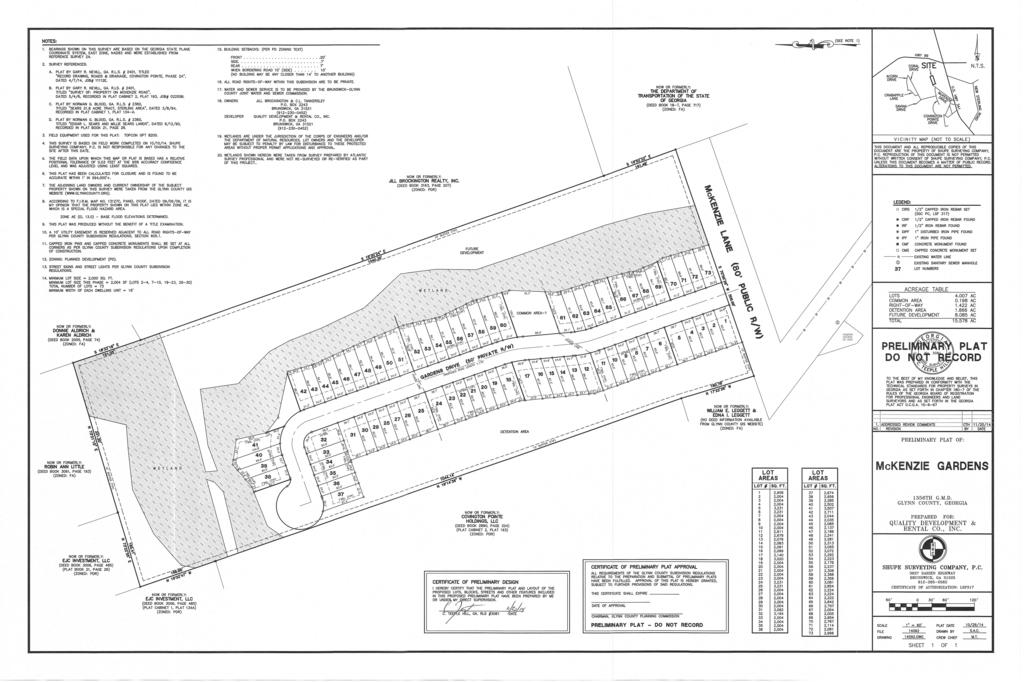
6 PP2944 Appendix A: Location Map OLD JESUP RD GI BI GISCO RANGE RD GODLEY RD WILLIE LN FA WILLIAMS RD NEW JESUP HWY LC M12 R12 GREEN SWAMP RD CHRIS RD RIPPLE LN KARA LN GC NEW JESUP HWY HIGHWAY 99 PD DEPRATTER LN GRANTS FERRY RD LANE WAY PP2944 EDNA WAY SAVINA DR MCKENZIE DR HC CAPALLTON DR CLINTON DR NEW STERLING RD PDR BRADLEY DR CP SAMS LN BRIAN DR GR FERNWOOD DR KEITH DR SWAN ST FINCH ST CALLAWAY CT CURRY LN R9 HOLTZ RD ELIZA LN CHARITY CIR MH Milesµ
7
8 GLYNN COUNTY COMMUNITY DEVELOPMENT REVIEW HISTORY for PP2944 McKenzie Gardens as of 11/24/ :27 pm Intake Desk Telephone Review # Assigned To Result Result By Due Completed Drainage 1 Ben Pierce Compliant Pierce 11/12/ /18/ Engineering 1 Robert Bowen NOT Compliant Bowen 11/12/ /19/2014 Violates SD ordinance---cul-de-sac road must be less than 1200ft Engineering 2 Robert Bowen Compliant Bowen 11/25/ /24/2014 After reading the PD text and talking to P. Andrews the following must be worked out: ZM was approved with the following: The applicant needs to work with County Engineering staff to provide a plan for resolving access. County Engineering and Public Works will need to determine if the existing street can provide adequate and safe access. No building permits or platting can be approved until adequate access to the site is approved by County Engineering The PP as it is does not address the provision of PD. It almost looks like additional R/W needs to be obtained to smooth out or eliminate corner and address the following provisions of the SD regulations. The approach redesign will be needed to allow project to comply with SD regulations a, b, c & d Fire Department 1 Fred Johnson Compliant Johnson 11/12/ /05/ Fire Department 2 Fred Johnson Compliant Johnson 11/12/ /05/2014 Must install fire hydrants every 500 feet GIS Address 1 Jimmie Hurlbut NOT Compliant Hurlbut 11/12/ /06/ McKenzie Drive will not work. We already have a McKenzie Drive and McKenzie Lane in this immediate area within the same ESN zone. Suggestion: Rename Subdivision and the entry road should carry the name of the subdivision. 2. Addresses are not on the plat GIS Address 2 Leigh Newton Compliant Newton 11/25/ /21/2014 Gardens Drive is compliant with the Addressing Ordinance per the plat revision dated 11/20/14. Shupe can contact GIS for addresses when they are ready GIS Mapping 1 Marilyn Proper NOT Compliant Proper 11/12/ /05/2014 PP2944 McKenzie Gardens Not Compliant. - Glynn County regulation requires the total subdivision land area in acres. - The adjoining parcel ELV INVESTMENT,LLC is zoned PDR. Please correct in both listings. The information submitted on has been entered into the data base GIS Mapping 2 Marilyn Proper 11/25/2014 Print Date: 11/24/2014 Page 1 of 2
9 Review # Assigned To Result Result By Due Completed Intake Desk 1 Denise Keller Compliant Keller 11/04/ JWSC 1 Elizabeth Burns Compliant Burns 11/12/ /06/ Planners Pre-Review 1 Cayce Dagenhart Compliant Dagenhart 11/05/ /05/2014 Ok to put on the agenda Planning and Zoning 1 Eric Johnson NOT Compliant Johnson 11/12/ /06/2014 Indicate the name, address, and telephone number of the owner of record Section In the box for Certificate of Preliminary Design, please include a space to insert the date Section Question: With respect to the new parcels that aren t assigned a lot number, are they common areas? Under Note 14, indicate the size of the entire parcel (total subdivision land area in acres Section 703.8). This will help in determining project density. Under Note 14, indicate, The minimum width on each dwelling unit after division of the building into individual dwelling units shall be no less than 16 feet. Under Note 15, please indicate that No building may be any closer than 14 feet from any other building. Also, graphically depict the rear and side (end unit only) setback lines to ensure compliance with this PD Text. Graphically depict a 10-foot wide buffer along all exterior property lines PD Text. The PD Text stipulates there will be a minimum of 20% green space within the development, which may include parks and wetland area. Please indicate by note the proposed green space to ensure compliance with the aforementioned. Indicate location of existing water and sewer utilities, if a connection to these public systems is proposed Section Indicate proposed unit division or state of development (project phasing), if any Section Question: The PD Text stipulates that each unit of a building will have two (2) off-street parking spaces. I assume this will be accomplished via tandem parking (1-car garage and a 1-car driveway)? Planning and Zoning 2 Eric Johnson Compliant Johnson 11/25/ /21/2014 Approved contingent upon the determination of County Engineering and Public Works determining existing street can provide adequate and safe access Resubmit 1 Denise Keller Compliant Keller 11/20/ Traffic 1 Ben Pierce Compliant Pierce 11/12/ /18/2014 Approved pending inhouse traffic counts and generation study. Pavement section may not be able to support this development. Number of Reviews 16 Print Date: 11/24/2014 Page 2 of 2
10 GLYNN COUNTY COMMUNITY DEVELOPMENT REVIEW HISTORY for PP2944 McKenzie Gardens as of 11/21/2014 1:59 pm Intake Desk Telephone Review # Assigned To Result Result By Due Completed Drainage 1 Ben Pierce Compliant Pierce 11/12/ /18/ Engineering 1 Robert Bowen NOT Compliant Bowen 11/12/ /19/2014 Violates SD ordinance---cul-de-sac road must be less than 1200ft Engineering 2 Robert Bowen NOT Compliant Bowen 11/25/ /21/2014 After reading the PD text and talking to P. Andrews the following must be worked out: ZM was approved with the following: The applicant needs to work with County Engineering staff to provide a plan for resolving access. County Engineering and Public Works will need to determine if the existing street can provide adequate and safe access. No building permits or platting can be approved until adequate access to the site is approved by County Engineering The PP as it is does not address the provision of PD. It almost looks like additional R/W needs to be obtained to smooth out or eliminate corner and address the following provisions of the SD regulations. The plat also appears to violate SD regulations a, b, c & d. These would seem to be fatal flaws to PP approval Fire Department 1 Fred Johnson Compliant Johnson 11/12/ /05/ Fire Department 2 Fred Johnson Compliant Johnson 11/12/ /05/2014 Must install fire hydrants every 500 feet GIS Address 1 Jimmie Hurlbut NOT Compliant Hurlbut 11/12/ /06/ McKenzie Drive will not work. We already have a McKenzie Drive and McKenzie Lane in this immediate area within the same ESN zone. Suggestion: Rename Subdivision and the entry road should carry the name of the subdivision. 2. Addresses are not on the plat GIS Address 2 Leigh Newton Compliant Newton 11/25/ /21/2014 Gardens Drive is compliant with the Addressing Ordinance per the plat revision dated 11/20/14. Shupe can contact GIS for addresses when they are ready GIS Mapping 1 Marilyn Proper NOT Compliant Proper 11/12/ /05/2014 PP2944 McKenzie Gardens Not Compliant. - Glynn County regulation requires the total subdivision land area in acres. - The adjoining parcel ELV INVESTMENT,LLC is zoned PDR. Please correct in both listings. The information submitted on has been entered into the data base GIS Mapping 2 Marilyn Proper 11/25/2014 Print Date: 11/21/2014 Page 1 of 2
11 Review # Assigned To Result Result By Due Completed Intake Desk 1 Denise Keller Compliant Keller 11/04/ JWSC 1 Elizabeth Burns Compliant Burns 11/12/ /06/ Planners Pre-Review 1 Cayce Dagenhart Compliant Dagenhart 11/05/ /05/2014 Ok to put on the agenda Planning and Zoning 1 Eric Johnson NOT Compliant Johnson 11/12/ /06/2014 Indicate the name, address, and telephone number of the owner of record Section In the box for Certificate of Preliminary Design, please include a space to insert the date Section Question: With respect to the new parcels that aren t assigned a lot number, are they common areas? Under Note 14, indicate the size of the entire parcel (total subdivision land area in acres Section 703.8). This will help in determining project density. Under Note 14, indicate, The minimum width on each dwelling unit after division of the building into individual dwelling units shall be no less than 16 feet. Under Note 15, please indicate that No building may be any closer than 14 feet from any other building. Also, graphically depict the rear and side (end unit only) setback lines to ensure compliance with this PD Text. Graphically depict a 10-foot wide buffer along all exterior property lines PD Text. The PD Text stipulates there will be a minimum of 20% green space within the development, which may include parks and wetland area. Please indicate by note the proposed green space to ensure compliance with the aforementioned. Indicate location of existing water and sewer utilities, if a connection to these public systems is proposed Section Indicate proposed unit division or state of development (project phasing), if any Section Question: The PD Text stipulates that each unit of a building will have two (2) off-street parking spaces. I assume this will be accomplished via tandem parking (1-car garage and a 1-car driveway)? Planning and Zoning 2 Eric Johnson Compliant Johnson 11/25/ /21/2014 Approved contingent upon the determination of County Engineering and Public Works determining existing street can provide adequate and safe access Resubmit 1 Denise Keller Compliant Keller 11/20/ Traffic 1 Ben Pierce Compliant Pierce 11/12/ /18/2014 Approved pending inhouse traffic counts and generation study. Pavement section may not be able to support this development. Number of Reviews 16 Print Date: 11/21/2014 Page 2 of 2
TO: Glynn County Islands Planning Commission. Karl W. Bursa, AICP, Planner II. PP3105 Stillwater Phase III. DATE: November 10, 2015
 COMMUNITY DEVELOPMENT DEPARTMENT Planning and Zoning Division 1725 Reynolds Street, Suite 200, Brunswick, GA 31520 Phone: 912-554-7428/Fax: 1-888-252-3726 TO: Glynn County Islands Planning Commission FROM:
TO: Glynn County Islands Planning Commission. Eric Landon, Planner II. PP2754 Stones Throw Cottages. DATE: February 6, 2014
 COMMUNITY DEVELOPMENT DEPARTMENT Planning and Zoning Division 1725 Reynolds Street, Suite 200, Brunswick, GA 31520 Phone: 912-554-7428/Fax: 1-888-252-3726 TO: Glynn County Islands Planning Commission FROM:
PLANNING COMMISSION STAFF REPORT
 COMMUNITY DEVELOPMENT DEPARTMENT Planning and Zoning Division 1725 Reynolds Street, Suite 200, Brunswick, GA 31520 Phone: 912-554-7428/Fax: 1-888-252-3726 PLANNING COMMISSION STAFF REPORT DATE: January
APPLICANT: Brunswick & Glynn County Development Authority, owner.
 GLYNN COUNTY BOARD OF COMMISSIONERS MEMO TO: Glynn County Mainland Planning Commission 701 G Street Brunswick, Georgia 31520 Phone: (912) 554-7400 Fax: (912) 554-7596 FROM: SUBJECT: Eric Landon, Planner
GLYNN COUNTY BOARD OF COMMISSIONERS OFFICE OF COMMUNITY DEVELOPMENT
 GLYNN COUNTY BOARD OF COMMISSIONERS OFFICE OF COMMUNITY DEVELOPMENT 1725 Reynolds Street - Suite 200 - Brunswick, Georgia 31520-6435 Phone: (912) 554-7428 MEMO TO: Glynn County Mainland Planning Commission
TO: Glynn County Board of Commissioners. Eric Landon, Planner II. ZM2773 Peppertree Crossing Phase II
 COMMUNITY DEVELOPMENT DEPARTMENT Planning and Zoning Division 1725 Reynolds Street, Suite 200, Brunswick, GA 31520 Phone: 912-554-7428/Fax: 1-888-252-3726 TO: Glynn County Board of Commissioners MEMO FROM:
TO: Glynn County Mainland Planning Commission. Iris M Thielen Johnston, AICP, Planner III. ZM2459 Planting Hammock. DATE: September 24, 2012
 MEMO COMMUNITY DEVELOPMENT DEPARTMENT Planning and Zoning Division 1725 Reynolds Street, Suite 200, Brunswick, GA 31520 Phone: 912-554-7428/Fax: 1-888-252-3726 TO: Glynn County Mainland Planning Commission
Minor Revision to Amend an Existing PD (Rezoning) RLF Kingsland Properties, LLC R-4 Tract Golden Isles Gateway Planned Development
 RLF Kingsland Properties, LLC R-4 Tract Golden Isles Gateway Planned Development") COMMUNITY DEVELOPMENT DEPARTMENT Planning and Zoning Division 1725 Reynolds Street, Suite 200, Brunswick, GA 31520 Phone: 912-554-7428/Fax: 1-888-252-3726 MAINLAND PLANNING COMMISSION STAFF REPORT MEETING
COMMUNITY DEVELOPMENT DEPARTMENT Planning and Zoning Division 1725 Reynolds Street, Suite 200, Brunswick, GA 31520 Phone: 912-554-7428/Fax: 1-888-252-3726 MAINLAND PLANNING COMMISSION STAFF REPORT MEETING
Project Description: Consider site plan approval for the construction of a new car wash in the Gateway Center subdivision.
 COMMUNITY DEVELOPMENT DEPARTMENT Planning and Zoning Division 1725 Reynolds Street, Suite 200, Brunswick, GA 31520 Phone: 912-554-7428/Fax: 1-888-252-3726 MAINLAND PLANNING COMMISSION STAFF REPORT August
MINOR SUBDIVISION PLAT CHECKLIST
 MINOR SUBDIVISION PLAT CHECKLIST Project Name: Tax ID #: Project Number: Date: _ Reviewed By: Telephone: NOTES: All lots on septic systems must comply with the Fulton County Health Department requirements
SUBDIVISION PLAT CHECKLIST. The following information shall be include on the plat:
 SUBDIVISION PLAT CHECKLIST Subdivision Name: Land Surveyor: Owner/Developer: Date Submitted: The following information shall be include on the plat: The plat shall be drawn at a scale of one inch equals
Minor Subdivision Application
 FOR PLANNING USE ONLY Application # SD Application Fee $1,000.00 Receipt No. Filing Date Completeness Date Minor Subdivision Application A. PROJECT INFORMATION 1. Project Name: 2. Address of Subject Property:
Lake County Planning, Building and Development Department
 SUBMISSION CHECKLIST FOR SUBDIVISION FINAL PLAT Lake County Planning, Building and Development Department 500 W. Winchester Rd. Unit 101 Libertyville, Illinois 60048-1331 Telephone (847) 377-2600 E-mail:
SUBJECT PARCEL(S) Property Owner(s) TMS Number Approximate Acreage Carolina Park Development, LLC
 Property Owner(s) TMS Number Approximate Acreage Carolina Park Development, LLC") Staff Report Special Planning Commission Meeting November 19, 2014 For reference, the Zoning Code and Land Development Regulations are available online. AGENDA ITEM 5c. SKETCH PLAN APPROVAL REQUEST: Request
Staff Report Special Planning Commission Meeting November 19, 2014 For reference, the Zoning Code and Land Development Regulations are available online. AGENDA ITEM 5c. SKETCH PLAN APPROVAL REQUEST: Request
BOSSIER CITY PARISH METROPOLITAN PLANNING COMMISSION 620 Benton Rd. Bossier City, LA Phone: Fax: PRELIMINARY PLAT
 (OFFICE USE ONLY) Application Fee: Paid: Date: CASE # Project Information BOSSIER CITY PARISH METROPOLITAN PLANNING COMMISSION 620 Benton Rd. Bossier City, LA 71111 Phone: 318-741-8824 Fax: 318-741-8827
SUBDIVISION APPLICATION CHECKLIST SKETCH PLAN PRELIMINARY PLAT FINAL PLAT
 RECEIVED STAMP SUBDIVISION APPLICATION CHECKLIST SKETCH PLAN PRELIMINARY PLAT FINAL PLAT A checklist of background information and submission requirements for processing of a sketch plan, preliminary plat
PRELIMINARY PLAT Checklist
 PRELIMINARY PLAT Checklist 3715 Bridgeport Way W University Place, WA 98466 PH: (253) 566-5656 FAX: (253) 460-2541 This is a checklist of materials required for a Preliminary Plat. This checklist is provided
5970 Golden Isles Parkway (Bergen Woods) Property Address. Planned Development (PD) Golden Isles Gateway Tract (GC-16-00) Existing Land Use
 Property Address. Planned Development (PD) Golden Isles Gateway Tract (GC-16-00) Existing Land Use") COMMUNITY DEVELOPMENT DEPARTMENT Planning and Zoning Division 125 Reynolds Street, Suite 200, Brunswick, GA 31520 Phone: 912-554-428/Fax: 1-888-252-326 BOARD OF COMMISSIONERS STAFF REPORT MEETING DATE:
COMMUNITY DEVELOPMENT DEPARTMENT Planning and Zoning Division 125 Reynolds Street, Suite 200, Brunswick, GA 31520 Phone: 912-554-428/Fax: 1-888-252-326 BOARD OF COMMISSIONERS STAFF REPORT MEETING DATE:
APPLICATION FOR MAJOR SUBDIVISION APPROVAL (PRELIMINARY PLAT)
") 209 S. Main Street Marysville, Ohio 43040 Phone: (937) 645-7350 Fax: (937) 645-7351 www.marysvilleohio.org APPLICATION FOR MAJOR SUBDIVISION APPROVAL (PRELIMINARY PLAT) *** IMPORTANT INFORMATION ~ Please
209 S. Main Street Marysville, Ohio 43040 Phone: (937) 645-7350 Fax: (937) 645-7351 www.marysvilleohio.org APPLICATION FOR MAJOR SUBDIVISION APPROVAL (PRELIMINARY PLAT) *** IMPORTANT INFORMATION ~ Please
Residential Major Subdivision Review Checklist
 Residential Major Subdivision Review Checklist Plan Submittal Requirements: 2 full sets of stamped plans Electric submittal - all plans contained in a single PDF 3 full sets if commercial kitchen or dining
Application for Preliminary Plat Checklist
 Application for Preliminary Plat Checklist Note: No portion of an existing parcel may be sold or transferred to another party without first legally subdividing the property according to the City of Richmond
Gates County Planning and Zoning
 Gates County Planning and Zoning PO Box 411, 200 Court Street, Gatesville, NC 27938 phone: 252-357-2411 fax: 252-357-0073 Application for Technical Review Committee For Staff Use Only: Date: Application
WASCO COUNTY PRELIMINARY SUBDIVISION APPLICATION
 WASCO COUNTY PRELIMINARY SUBDIVISION APPLICATION DETAILED SPECIFIC WRITTEN REQUEST File Number: SDV- Number of Proposed Lots & their Dimensions: PRELIMINARY SUBDIVISION PLAN REQUIREMENTS The approval of
FINAL PLAT APPLICATION
 FINAL PLAT APPLICATION (Page 1 of 3) LEGAL OWNER(s): NAME: STREET ADDRESS OWNER(s): CITY, STATE, ZIP CODE: PHONE NUMBER: BILLING ADDRESS: NAME OF ENGINEER/SURVEYOR: Engineer/Surveyor Address, Phone: PROPERTY
I. Requirements for All Applications. C D W
 108-16.1. Application checklists. Checklist for Required Submissions to the Planning Board or Zoning Board of Adjustment of Monroe Township All required submissions are to be made to the Administrative
Residential Minor Subdivision Review Checklist
 Residential Minor Subdivision Review Checklist Plan Submittal Requirements: 2 full sets of stamped plans Electric submittal - all plans contained in a single PDF 3 full sets if commercial kitchen or dining
PRELIMINARY PLATS. The following documents are provided as required by the City of Conroe for use in the above titled platting submittals:
 Public Works Engineering Division CITY OF CONROE PRELIMINARY PLATS The following documents are provided as required by the City of Conroe for use in the above titled platting submittals: Submittal Questionnaire
701 G Street Brunswick, Georgia Phone: (912) Fax: (912)
 Fax: (912)") GLYNN COUNTY BOARD OF COMMISSIONERS MEMO TO: Glynn County Mainland Planning Commission 701 G Street Brunswick, Georgia 31520 Phone: (912) 554-7400 Fax: (912) 554-7596 FROM: SUBJECT: Eric Landon, Planner
GLYNN COUNTY BOARD OF COMMISSIONERS MEMO TO: Glynn County Mainland Planning Commission 701 G Street Brunswick, Georgia 31520 Phone: (912) 554-7400 Fax: (912) 554-7596 FROM: SUBJECT: Eric Landon, Planner
Preliminary Plat/Final Plat Application
 Melissa Municipal Center 3411 Barker Avenue Melissa, Texas 75454 Phone: (972) 838-2036 Applicant: Date: Address: Phone: Contact: Fax: E-mail: Propose Addition Name: Acres: Existing Zoning: Propose Zoning:
CONCEPT PLAN SUBMISSION REQUIREMENTS:
 STAFF STRONGLY RECOMMENDS A PRE-DEVELOPMENT MEETING BEFORE THE SUBMITTAL OF ANY APPLICATION FOR ZONING, REZONING, CONDITIONAL USE PERMIT (CUP), OR FOR A TEXT AMENDMENT TO A PROVISION(S) OF THE ZONING ORDINANCE.
ELK RAPIDS TOWNSHIP ANTRIM COUNTY, MICHIGAN ORDINANCE NO
 ELK RAPIDS TOWNSHIP ANTRIM COUNTY, MICHIGAN ORDINANCE NO. 3-2011 AN ORDINANCE TO REPLACE THE SUBDIVISION CONTROL ORDINANCE WITH A NEW SUBDIVISION DEVELOPMENT ORDINANCE, IN ACCORD WITH THE LAND DIVISION
ARTICLE SINGLE FAMILY SITE CONDOMINIUM DEVELOPMENT STANDARDS
 ARTICLE 28.00 SINGLE FAMILY SITE CONDOMINIUM DEVELOPMENT STANDARDS Section 28.01 PURPOSE The purpose of this Article is to recognize that conventional single family developments, traditionally developed
CHECKLIST FOR DEVELOPMENT REVIEW
 CHECKLIST FOR DEVELOPMENT REVIEW Petitions and related documents and plans for land development or other proposals regulated by Title 16 of the Municipal Code (Development Ordinance) and Title 17 of the
APPLICATION FOR MAJOR SUBDIVISION APPROVAL (FINAL PLAT)
") 209 S. Main Street Marysville, Ohio 43040 Phone: (937) 645-7350 Fax: (937) 645-7351 www.marysvilleohio.org APPLICATION FOR MAJOR SUBDIVISION APPROVAL (FINAL PLAT) *** IMPORTANT INFORMATION ~ Please read
209 S. Main Street Marysville, Ohio 43040 Phone: (937) 645-7350 Fax: (937) 645-7351 www.marysvilleohio.org APPLICATION FOR MAJOR SUBDIVISION APPROVAL (FINAL PLAT) *** IMPORTANT INFORMATION ~ Please read
DRAFT FOR PUBLIC HEARING (rev. March, 2016)
") Chapter 200. ZONING Article VI. Conservation/Cluster Subdivisions 200-45. Intent and Purpose These provisions are intended to: A. Guide the future growth and development of the community consistent with
Chapter 200. ZONING Article VI. Conservation/Cluster Subdivisions 200-45. Intent and Purpose These provisions are intended to: A. Guide the future growth and development of the community consistent with
SUBDIVISION AND LAND DEVELOPMENT. 185 Attachment 20
 185 Attachment 20 APPENDIX S Plat No. Date of Submission Twp. Fee $ Dauphin Co. Fee $ TOWNSHIP OF DERRY SUBDIVISION OR LAND DEVELOPMENT PLAN SUBMISSION APPLICATION This block for Twp. use only 1. Title
APPLICATION FOR PRELIMINARY PLAT RESIDENTAIL. FILING FEE: $ for the first 20 lots; $10.00 for each additional lot over 20
 COMMUNITY PLANNING & DEVELOPMENT TELEPHONE.* (816) 331-4331 FAX * (816) 331-6973 CITY HALL ANNEX 520 MAIN STREET BELTON, MISSOURI 64012 WEBSITE * www.belton.org APPLICATION FOR PRELIMINARY PLAT RESIDENTAIL
ARTICLE XVI SUBDIVISION DEVELOPMENT
 ARTICLE XVI SUBDIVISION DEVELOPMENT 16.0 The division of land into 4 or more lots that will require the construction or extension of public streets, water or sanitary sewerage (other than the direct connection
CITY OF FAYETTEVILLE, ARKANSAS FINAL PLAT FOR STAFF USE ONLY FINAL PLAT FEE: $ $ Date Application Submitted: Date Accepted as Complete:
 CITY OF FAYETTEVILLE, ARKANSAS FINAL PLAT FOR STAFF USE ONLY FINAL PLAT FEE: $200.00-$800.00 Date Application Submitted: Date Accepted as Complete: Project Number: Public Hearing S-T-R: PP#: Zone: Please
Applications will be received on business days between 9:00 AM and 3:00 PM
 Special Use Permit Application Douglas County Board of Commissioners Douglas County, Georgia Applications will be received on business days between 9:00 AM and 3:00 PM Date of Application: Application
CERTIFICATION OF THE APPROVAL OF WATER AND SEWERAGE SYSTEMS
 ARTICLE 9 FORMS AND CHECK LISTS 9.100 On preliminary layout & final subdivision plat CERTIFICATION OF THE APPROVAL OF WATER AND SEWERAGE SYSTEMS I hereby certify that the (...type: private or pubic...)
CITY OF LEE S SUMMIT MINOR PLAT PROCESS. Purpose of Minor Plats
 MINOR PLAT PROCESS Purpose of Minor Plats The City of Lee s Summit requires that all property be platted before a building permit is issued. Platting involves the subdivision of land into lots or tracts.
COUNTY OF ALBEMARLE APPLICATION FOR FAMILY DIVISION. Family Division = $742 (Provide 5 copies of plat)
") Page 1 APPLICATION FOR FAMILY DIVISION Family Division = $742 (Provide 5 copies of plat) Tier 2 Groundwater Review = $355 (Required for all plats showing lots less than 21 acres) Tier 3 Groundwater Review
Page 1 APPLICATION FOR FAMILY DIVISION Family Division = $742 (Provide 5 copies of plat) Tier 2 Groundwater Review = $355 (Required for all plats showing lots less than 21 acres) Tier 3 Groundwater Review
SUBDIVISION APPLICATION: RECOMBINATION PLAT or EXEMPT PLAT
 SUBDIVISION APPLICATION: RECOMBINATION PLAT or EXEMPT PLAT Pursuant to Article 7, Section 155.706 of the Unified Development Code, an owner of land within the jurisdiction of the Town (or a duly authorized
COUNTY OF ALBEMARLE APPLICATION FOR RURAL SUBDIVISION
 Page 1 APPLICATION FOR RURAL SUBDIVISION The term rural subdivision means a type of subdivision that is located in the rural areas which results in two or more lots for the purpose of transfer of ownership
610 LAND DIVISIONS AND PROPERTY LINE ADJUSTMENTS OUTSIDE A UGB
 ARTICLE VI: LAND DIVISIONS AND PROPERTY LINE ADJUSTMENTS VI-21 610 LAND DIVISIONS AND PROPERTY LINE ADJUSTMENTS OUTSIDE A UGB 610-1 Property Line Adjustments (Property Line Relocation) A property line
Richmond County Subdivision By-law
 Richmond County Subdivision By-law SHORT TITLE 1. This By-law may be cited as the "Subdivision By-law" and shall apply to all lands within the Municipality of the County of Richmond. INTERPRETATION 2.
Watertown City Council
 City of Watertown Watertown City Council 2/14/2017 Agenda Item: Riverpointe Subdivision 2 nd Replat Request for Action: Sketch Plan Department: Planning Request for Action Request: Paxmar, LLC (Applicant)
LAND USE APPLICATION
 Lincoln County Department of Planning & Development 210 SW 2nd Street, Newport, OR 97365 Phone (541) 265-4192 Fax (541) 265-6945 LAND USE APPLICATION TO BE COMPLETED BY STAFF Conditional Use Non-Conforming
CITY OF SARALAND PRELIMINARY SUBDIVISION PLAT REVIEW
 PRELIMINARY SUBDIVISION PLAT REVIEW Application Number: Date Plat Submitted: Name of Subdivision: Name of Owner: Owner Address: (Street or P.O. Box) Telephone #: (City) (State) (Zip) E-mail: Name of Authorized
Residential Subdivision Design Regulations
 Residential Subdivision Design Regulations Section 121. Street Requirements ARTICLE XII PROCEDURES FOR SUBDIVISION PLAT APPROVAL 121.4 Legal Status of Public Street required. No land dedicated as a public
R e z o n i n g A p p l i c a t i o n S u b m i s s i o n R e q u i r e m e n t s
 H O R R Y C O U N T Y P L A N N I N G & Z O N I N G 1 3 0 1 2 N D A V E., S U I T E 1 D - 0 9 C O N W A Y, S. C. 2 9 5 2 6 P H O N E : 8 4 3. 9 1 5. 5 3 4 0 F A X : 8 4 3. 9 1 5. 6 3 4 1 R e z o n i n
ARTICLE III GENERAL PROCEDURES, MINOR PLANS AND FEE SCHEDULES
 ARTICLE III GENERAL PROCEDURES, MINOR PLANS AND FEE SCHEDULES 301. Prior to Submission a. Copies of this Ordinance shall be available on request, at cost, for the use of any person who desires information
Preliminary Subdivision Application (Minor) (Three (3) lots or less)
 (Three (3) lots or less)") Gunnison City Offices www.gunnisoncity.org 38 West Center Gunnison, Utah 84634 (435) 528 7969 Date of Application: Preliminary Subdivision Application (Minor) (Three (3) lots or less) APPLICANT INFORMATION
Gunnison City Offices www.gunnisoncity.org 38 West Center Gunnison, Utah 84634 (435) 528 7969 Date of Application: Preliminary Subdivision Application (Minor) (Three (3) lots or less) APPLICANT INFORMATION
MINOR PLAT. The following documents are provided as required by the City of Conroe for use in the above titled platting submittals:
 Public Works - Engineering Division CITY OF CONROE MINOR PLAT The following documents are provided as required by the City of Conroe for use in the above titled platting submittals: Submittal Questionnaire
A.3. ARTICLE 7 PLAN REQUIREMENTS FOR MINOR SUBDIVISION AND/OR LAND DEVELOPMENT
 700. 701.A.3. ARTICLE 7 PLAN REQUIREMENTS FOR MINOR SUBDIVISION AND/OR LAND DEVELOPMENT SECTION 700 PURPOSE The purpose of this Article is to set forth a streamlined set of Plan Requirements for minor
Preliminary Subdivision Application (Major) (Four (4) lots or more)
 (Four (4) lots or more)") Gunnison City Offices www.gunnisoncity.org 38 West Center Gunnison, Utah 84634 (435) 528 7969 Date of Application: Preliminary Subdivision Application (Major) (Four (4) lots or more) APPLICANT INFORMATION
Gunnison City Offices www.gunnisoncity.org 38 West Center Gunnison, Utah 84634 (435) 528 7969 Date of Application: Preliminary Subdivision Application (Major) (Four (4) lots or more) APPLICANT INFORMATION
TO: Glynn County Board of Commissioners. Karl Bursa, AICP - Planner II. ZM3153 Plumbroke Road. DATE: February 8, 2016
 COMMUNITY DEVELOPMENT DEPARTMENT Planning and Zoning Division 1725 Reynolds Street, Suite 200, Brunswick, GA 31520 Phone: 912-554-7428/Fax: 1-888-252-3726 TO: Glynn County Board of Commissioners MEMO FROM:
Plans shall be drawn at a readable scale, signed, and sealed by a Florida Registered Engineer. The application package shall include:
 CHAPTER 400. SECTION 403. PERMIT TYPES AND APPLICATIONS SITE DEVELOPMENT 403.3. Preliminary Site Plans (PSP) A. Intent and Purpose PSPs are used to identify existing site conditions and demonstrate general
FINAL PLAT CHECKLIST
 FINAL PLAT CHECKLIST Project Name: Tax ID #: Project Number: Date: _ Reviewed By: Telephone: Please address all items marked with an "X" Please return redline comments with corrected plan, original mylar,
Section 3.0: RESIDENTIAL AND NON-RESIDENTIAL SUBDIVISION APPLICATION AND APPROVAL PROCESS
 Cherokee County Development Ordinance Adopted - January 15, 2002 3-1 Section 3.0: RESIDENTIAL AND NON-RESIDENTIAL SUBDIVISION APPLICATION AND APPROVAL PROCESS It shall be the policy of the Cherokee County
CHAPTER 4 FINAL PLAT
 10-4-1 10-4-2 CHAPTER 4 FINAL PLAT SECTION: 10-4-1: Tentative Final Plat 10-4-2: Filing 10-4-3: Requirements 10-4-4: Amended Plats 10-4-5: Approval 10-4-6: Subdivision Agreement 10-4-1: TENTATIVE FINAL
ARTICLE 15. RULES, REGULATIONS AND DEFINITIONS
 ARTICLE 15. RULES, REGULATIONS AND DEFINITIONS Section 1. Interpretation and Construction: The following rules and regulations regarding interpretation and construction of the Ulysses-Grant County, Kansas,
TOWN OF OCEAN ISLE BEACH
 TOWN OF OCEAN ISLE BEACH PLANNED UNIT DEVELOPMENT ORDINANCE ADOPTED IN EFFECT FEBRUARY 13, 2001 This ordinance has been prepared by the Ocean Isle Beach Planning & Inspections Department. Section 66-55.
MINOR SUBDIVISION FINAL PLAT APPLICATION Town of Apex, North Carolina
 MINOR SUBDIVISION FINAL PLAT APPLICATION Town of Apex, North Carolina This document is a public record under the North Carolina Public Records Act and may be published on the Town s website or disclosed
PLANNING COMMISSION REPORT Regular Agenda Non Public Hearing Item
 PC Staff Report 3/23/15 FDP-14-00551 Item No. 2-1 PLANNING COMMISSION REPORT Regular Agenda Non Public Hearing Item PC Staff Report 3/23/15 ITEM NO. 2: FINAL DEVELOPMENT PLAN FOR HUTTON FARMS WEST PHASE
SECTION 10 STANDARD PLATS
 SECTION 10 - STANDARD PLATS Subdivision 1: Purpose Standard Plats allow the subdivision of land into lots smaller than the minimum metes and bounds size in the zoning district, and control road development
Chapter 405 SUBDIVISION OF LAND
 Chapter 405 SUBDIVISION OF LAND Cross References As to city zoning and planning commission generally, 400.280 400.290; as to buildings generally, ch. 500; as to mobile homes and mobile home parks generally,
ARTICLE 24 SITE PLAN REVIEW
 ARTICLE 24 SITE PLAN REVIEW 24.1 PURPOSE: The intent of these Ordinance provisions is to provide for consultation and cooperation between the land developer and the Township Planning Commission in order
CITY OF SPRINGDALE, OHIO SPRINGDALE BUILDING DEPARTMENT SPRINGFIELD PIKE SPRINGDALE, OHIO TELEPHONE: (513)
") CITY OF SPRINGDALE, OHIO SPRINGDALE BUILDING DEPARTMENT 11700 SPRINGFIELD PIKE SPRINGDALE, OHIO 45246 TELEPHONE: (513) 346-5730 SUBMISSION REQUIREMENTS AND INSTRUCTIONS FOR MAJOR CHANGE TO A PRELIMINARY
CITY OF SPRINGDALE, OHIO SPRINGDALE BUILDING DEPARTMENT 11700 SPRINGFIELD PIKE SPRINGDALE, OHIO 45246 TELEPHONE: (513) 346-5730 SUBMISSION REQUIREMENTS AND INSTRUCTIONS FOR MAJOR CHANGE TO A PRELIMINARY
CHAPTER 22 SUBDIVISION AND LAND DEVELOPMENT
 CHAPTER 22 SUBDIVISION AND LAND DEVELOPMENT 22-101. Title 22-102. Legislative Intent Part 1 General Provisions 22-201. Development Permits Part 2 Administration 22-301. Fee Schedule Part 3 Fee Schedule
A. Appropriate agency responsible for transportation review for the subject property.
 7.8.10 Procedure Any person desiring to create a minor subdivision shall submit to the Commission for approval an application on forms provided by the Division, and a record plat in conformance with the
APPLICATION FOR PRELIMINARY PLAT CERRO GORDO COUNTY, IOWA
 APPLICATION FOR PRELIMINARY PLAT CERRO GORDO COUNTY, IOWA Before subdividing any tract of land and previous to the filing of an Application for conditional approval of the Preliminary Plat, the subdivider
WILTON MANORS, Island City 2020 WILTON DRIVE, WILTON MANORS, FLORIDA 33305
 WILTON MANORS, Island City 2020 WILTON DRIVE, WILTON MANORS, FLORIDA 33305 COMMUNITY DEVELOPMENT SERVICES (954) 390-2180 FAX: (954) 567-6069 PLAT APPLICATION PACKAGE This package includes: General Submittal
ORDINANCE NO. Be it ordained by the City Council of the City of Abilene, Texas:
 ORDINANCE NO. An ordinance repealing Chapter 23, Subpart B of the Code of the City of Abilene, Texas, entitled Mobile Homes and Vacation Travel Trailers; stating the authority; setting forth the scope
City of Suwanee Development Regulations ARTICLE 10 PLAN AND PLAT SPECIFICATIONS
 ARTICLE 10 PLAN AND PLAT SPECIFICATIONS 10.1 CONCEPT PLAN SPECIFICATIONS The following paragraphs outline the required elements of both the required and optional plans and plats mentioned throughout these
City of Prior Lake APPLICATION FOR REGISTERED LAND SURVEY
 Case File No. Property Identification No. City of Prior Lake APPLICATION FOR REGISTERED LAND SURVEY Requested Action Brief description of proposed project (Please describe the proposed amendment, project,
PLANNING COMMISSION SUBDIVISION PLAT APPLICATION
 PLANNING COMMISSION SUBDIVISION PLAT APPLICATION Economic Development Department 3468 North Fulton Avenue Hapeville, Georgia 30354 Phone - 404.669.8269 Fax 404.669.3302 Rev. 09/23/16 1 The following information
FINAL PLAT. Community Development Department 8101 Ralston Road Arvada, Colorado 80002
 FINAL PLAT Community Development Department 8101 Ralston Road Arvada, Colorado 80002 September 2015 FINAL SUBDIVISION PLAT Final Subdivision Plat Review Applications for a Final Plat shall be submitted
MAJOR SUBDIVISION PRELIMINARY PLAT CHECKLIST
 TOWNSHIP OF EGG HARBOR PLANNING BOARD/ZONING BOARD OF ADJUSTMENT 3515 BARGAINTOWN ROAD EGG HARBOR TOWNSHIP, NJ 08234 MAJOR SUBDIVISION PRELIMINARY PLAT CHECKLIST The following checklist is designed to
WESTON COUNTY FINAL PLAT APPLICATION
 WESTON COUNTY FINAL PLAT APPLICATION Property Owner: Mailing Address of owner: Telephone Number(s) of owner: Property Owner: Mailing Address of owner: Telephone Number(s) of owner: (If subdivider/applicant
Section SKETCH PLAN REVIEW
 Section 210 - SKETCH PLAN REVIEW 1. Within 30 days of receiving a complete application for a subdivision involving three or more lots, the Zoning Administrator shall refer the matter to the first available
SUBMISSION REQUIREMENTS AND INSTRUCTIONS FOR MINOR REVISIONS TO PUD PLANS
 WEST CHESTER TOWNSHIP, BUTLER COUNTY, OHIO COMMUNITY DEVELOPMENT DEPARTMENT 9577 Beckett Road, Suite 100, West Chester, Ohio 45069 TELEPHONE: (513) 777-4214 www.westchesteroh.org SUBMISSION REQUIREMENTS
TOWN OF NORTHWOOD, NEW HAMPSHIRE
 TOWN OF NORTHWOOD, NEW HAMPSHIRE OFFICE OF THE PLANNING BOARD 818 First New Hampshire Turnpike, Northwood NH 03261 (603)942-5586 Extension 205 Facsimile: (603)942-9107 Major Subdivision Application Form
FINAL SUBDIVISION AND LAND DEVELOPMENT PLAN CHECKLIST. Plan Name. Applicant's Name:
 TOWNSHIP OF UPPER ST. CLAIR FINAL SUBDIVISION AND LAND DEVELOPMENT PLAN CHECKLIST Date Filed Plan Name PLC Applicant's Name: Phone Filing Date for Final Application Final Plat 114.22. FINAL APPLICATION
SUBDIVISION APPLICATION
 SUBDIVISION APPLICATION Preliminary Plat Minor Plat Final Plat Amended Plat Applicant Name: Owner (if different from applicant) Name: Company: Company: Address: Address: City, State, Zip City, State, Zip
PLANNED DEVELOPMENT DISTRICT STANDARDS. Cadence Site
 PLANNED DEVELOPMENT DISTRICT STANDARDS Cadence Site A Planned Development District 1. Statement of General Facts, Conditions and Objectives Property Size: Approximately 57.51 Acres York County Tax Map
Minor Replat Celebration Pointe Peterson Road TECHNICAL REVIEW PROJECT: #
 March 15, 2018 Tony Huerta 3501 Industrial 29 th Street Fort Pierce, FL 34946 SUBJECT: Comments: Minor Replat Celebration Pointe - 5501 Peterson Road TECHNICAL REVIEW PROJECT: # 18-05000001 1. The plan
SECTION 10.7 R-PUD (RESIDENTIAL PLANNED UNIT DEVELOPMENT) ZONE
 ZONE") Article X Zones 10-20 SECTION 10.7 R-PUD (RESIDENTIAL PLANNED UNIT DEVELOPMENT) ZONE A. PURPOSE AND INTENT: The R-PUD Residential PUD Zone is intended to provide alternative, voluntary zoning procedures
Article X Zones 10-20 SECTION 10.7 R-PUD (RESIDENTIAL PLANNED UNIT DEVELOPMENT) ZONE A. PURPOSE AND INTENT: The R-PUD Residential PUD Zone is intended to provide alternative, voluntary zoning procedures
APPLICATION SUBMITTAL REQUIREMENTS FOR Tentative Parcel or Subdivision Maps
 CITY OF EL CERRITO Community Development Department Planning and Building Division 10890 San Pablo Avenue, El Cerrito, CA 94530 (510) 215-4330 FA (510) 233-5401 planning@ci.el-cerrito.ca.us APPLICATION
MINOR PLAT FILING APPLICATION
 FILING APPLICATION Date of PC Meeting: Date of BCC Meeting: Fee Paid: 1. APPLICANT: DAYTIME PHONE: MAILING ADDRESS: LANDOWNER: DAYTIME PHONE: MAILING ADDRESS: AUTHORIZED AGENT: MAILING ADDRESS: RELATIONSHIP
-~~Y~G'--'7<----'W.~"-""5-'--f_Lh,U='-...,tr,.LIV.,_,/"""''"""'~:: Home phone:
 ZONING I REZONING APPLICATION Application #2015- Heari Date: (PLEASE PRINT OR TYPE ALL INFORMATION) Applicant: Jic:..-=-~---=-..!
MASTER SUBDIVISION FINAL PLAT APPLICATION Town of Apex, North Carolina
 MASTER SUBDIVISION FINAL PLAT APPLICATION Town of Apex, North Carolina This document is a public record under the North Carolina Public Records Act and may be published to the Town s website or disclosed
SUBMITTAL REQUIREMENTS: The number indicates the number of copies for submittal (if applicable).
.") Office Use Only Preliminary Long Plat Long Subdivision Applicant Checklist PLANNING, COMMUNITY, & ECONOMIC DEVELOPMENT DEPARTMENT FINAL LONG PLAT LONG SUBDIVISION CHECKLIST Mailing Address: P.O. Box 547,
Office Use Only Preliminary Long Plat Long Subdivision Applicant Checklist PLANNING, COMMUNITY, & ECONOMIC DEVELOPMENT DEPARTMENT FINAL LONG PLAT LONG SUBDIVISION CHECKLIST Mailing Address: P.O. Box 547,
Sketch Plan 2018 Bargersville Plan Commission Application Kit
 Sketch Plan 2018 Bargersville Plan Commission Application Kit For Commercial, Industrial, and Residential Developments At least 31 days prior to the intended filing of the Primary Plat or Development Plan
PRELIMINARY SUBDIVISION PLAN APPLICATION INSTRUCTIONS
 City of Chesapeake Department of Planning Post Office Box 15225 Chesapeake, Virginia 23328-5225 (757) 382-6176 FAX (757) 382-6406 PRELIMINARY SUBDIVISION PLAN APPLICATION INSTRUCTIONS PURPOSE A preliminary
TOWN OF ROXBURY PLANNING BOARD
 UPDATED: APRIL 2011 TOWN OF ROXBURY PLANNING BOARD Applicant s Guide for Subdivision Review The Town Planning Board administers the subdivision review process. This guide has been prepared in order to
DIVISION 2 - CONSTRUCTION PLAN AND MISCELLANEOUS REQUIREMENTS
 DIVISION 2 - CONSTRUCTION PLAN AND MISCELLANEOUS REQUIREMENTS 2.1 Required Plan Sheets 2.2 Drawing Requirements 2.3 Graphic Standards 2.4 Easements 2.5 Utility Locations 2.6 Private Facility Locations
APPENDIX B. SUBMISSION REQUIREMENTS
 Master Major Site Minor Site Landscape Section B.1 Table of /Plat Requirements Proposed or approved name of development, project, subdivision, and/or phase. Location, including township, county, and state.
APPENDIX A SUBDIVISIONS*
 APPENDIX A SUBDIVISIONS* * Editors Note: Printed herein are the subdivision regulations adopted by the county commission on August 21, 2007, and amended through December 18, 2007. These regulations replace