TOWN OF MOUNT PLEASANT, SOUTH CAROLINA COMMITTEES OF COUNCIL MEETINGS
|
|
|
- Ronald Rose
- 6 years ago
- Views:
Transcription


1 TOWN OF MOUNT PLEASANT, SOUTH CAROLINA COMMITTEES OF COUNCIL MEETINGS Municipal Complex Building A - Public Meeting Room Ann Edwards Lane, Mount Pleasant, SC ************************** MONDAY, JULY 1, 2013 Planning and Development Committee 9:30 a.m. *************** The following Committees will not meet: Annexation Committee Bids and Purchases Committee Economic Development Committee Finance Committee Fire Committee Human Resources Committee Police, Judicial, and Legal Committee Public Services Committee Recreation Committee Transportation Committee Water Supply Committee *************** 100 Ann Edwards Lane Mount Pleasant, South Carolina tel (843) fax (843)
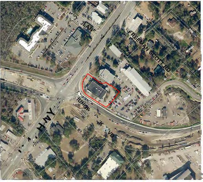
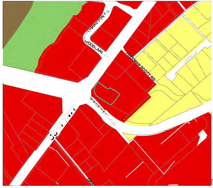
2 TOWN OF MOUNT PLEASANT, SOUTH CAROLINA MEETING NOTICE PLANNING AND DEVELOPMENT COMMITTEE MONDAY, JULY 1, :30 a.m. Municipal Complex Building A - Public Meeting Room Ann Edwards Lane, Mount Pleasant, SC * * * * * * * * * * * * * * * A G E N D A 1. Approval of Minutes from the June 3, 2013 meeting and the June 20, 2013 special meeting 2. Employee years of service recognition 3. Review of Planning Commission recommendations from the June 19, 2013 meeting a. Request to rezone from AB, Areawide Business District, to AB-2, Areawide Business-2 District an approximately 1.18 acre parcel of land located at 1603 US Highway 17 North, also known as Parcel 1, Four Mile Subdivision, also known as the former CVS site, and identified by TMS No b. Request to amend the Wilson Tract Planned Development District ordinance (Ord. No ) as it pertains to an approximately acre portion of an approximately acre tract of land known as Towne Centre, located between Hungryneck Boulevard and US Highway 17 North and identified by TMS Nos , , , , , , and , by increasing the maximum height for a hotel use from 35 feet to Ann Edwards Lane Mount Pleasant, South Carolina tel (843) fax (843)
3 feet, measured to the eave; by increasing the maximum height for a parking structure from 35 feet to 42 feet; by modifying the required building and parking structure setback from Hungryneck Boulevard; and by allowing all parking spaces (beyond the maximum required) to be paved, rather than pervious. Impact assessment and conceptual plan approval also. c. Request to amend the Bridgeside II Planned Development District ordinance (Ord. No ) to allow for a modification of the build-to line requirement along Harry M. Hallman, Jr. Boulevard, specifically to allow for consideration of a building setback when public open spaces abut the street. This amendment applies to those portions of an approximately acre tract of land that abut Harry M. Hallman, Jr. Boulevard, which are located near the intersection of Patriots Point and Harry M. Hallman, Jr. Boulevards and are identified by TMS Nos , , , , , , , and Update on the Use Table 5. Announcement of the 2013 Planning and Development Meet and Greet 6. Adjourn 100 Ann Edwards Lane Mount Pleasant, South Carolina tel (843) fax (843)
4 DISCLAIMER: These minutes are considered a draft until reviewed and approved by the Planning Commission at its next regularly scheduled meeting. TOWN OF MOUNT PLEASANT, SOUTH CAROLINA PLANNING COMMISSION JUNE 19, 2013 MINUTES Present: Staff: Roy Neal, chair, Todd Richardson, Howard Chapman, Bob Brimmer, Henry Middleton, Alice Richter-Lehrman, Phil Siegrist, Cheryll Woods-Flowers, Nick Collins. Christiane Farrell, David Pagliarini, Kent Prause, Kelly Cousino Mr. Neal called the meeting to order at 5:02 p.m. 1. Approval of Minutes Mr. Chapman moved for approval of the minutes with the following corrections: Page 11, third paragraph from bottom remove "is" Page 16 change to "vote" not voted. Ms. Richter-Lehrman seconded the motion. All in favor. 2. Correspondence and general public statements a. Update on Planning Commission recommendations. Ms. Cousino reviewed Town Council decisions with the Commission. Ms. Cousino stated that the rezoning request for 1203 Calais Drive has been withdrawn and noted that the same request cannot be made for at least one year unless Town Council grants a waiver. 3. Requests A. REZONING REQUEST PUBLIC HEARING: Request to rezone from R-1, Low Density Residential District, to LO, Limited Office District, an approximately 0.29 acre parcel of land located at 1203 Calais Drive, also known as Part Lot 1, Block B, Section 1, Heritage Subdivision, and identified by TMS No This request was withdrawn by the applicant. B. REZONING REQUEST PUBLIC HEARING: Request to rezone from AB, Areawide Business District, to AB-2, Areawide Business-2 District an approximately 1.18 acre parcel of land located at 1603 US Highway 17 North, also known as Parcel 1, Four Mile Subdivision, also known as the former CVS site, and identified by TMS No Ms. Cousino reviewed staff comments as follows: The property was acquired from CVS by the Town by eminent domain for the I-526 overpass construction and was subsequently conveyed to Doug McElveen as part of a settlement agreement as a result of condemnation proceedings for acquisition of a portion of his automobile dealership property for the same roadway project. In the interim it was used as the construction office for the overpass and Highway 17 widening projects. In order to use the property for automobile sales, rezoning to AB-2, Areawide Business- 2 District, and special exception approval by the Board of Zoning Appeals is required.
5 Planning Commission June 19, 2013 Page 2 of 10 The property is located in an area designated as commercial on the Town s Comprehensive Plan Future Land Use Map and the AB-2 zoning district classification is appropriate for this recommendation. The following is a list of applicable Comprehensive Plan goals and strategies and is provided so that they may be considered along with this request for rezoning. o Promote the growth of existing businesses and the recruitment of new businesses that are compatible with the Town s future vision. o Encourage appropriate commercial development to increase the property tax base and minimize the tax burden on homeowners. Mr. Chapman asked if there were any restrictions put on the site when the property was sold to McElveen. Mr. Pagliarini answered that to his knowledge there were no deed restrictions. He stated that there is currently a lease agreement between the Town and McElveen. Mr. Neal closed the public hearing. Mr. Chapman suggested that this was a good use. He suggested that access be restricted and only the existing McElveen access should be used for both sites. Ms. Cousino answered that it cannot be restricted through the zoning, but they would be required to apply for a special exception and this could be stipulated during that approval process if the Board of Zoning Appeals (BOZA) feels it is warranted. Ms. Cousino stated that this would be passed along to the BOZA staff liaison. Mr. Collins moved for approval. Mr. Richardson seconded the motion. All in favor. C. PLANNED DEVELOPMENT AMENDMENT REQUEST PUBLIC HEARING; IMPACT ASSESSMENT & CONCEPTUAL PLAN APPROVAL REQUEST: Request to amend the Wilson Tract Planned Development District ordinance (Ord. No ) as it pertains to an approximately acre portion of an approximately acre tract of land known as Towne Centre, located between Hungryneck Boulevard and US Highway 17 North and identified by TMS Nos , , , , , , and , by increasing the maximum height for a hotel use from 35 feet to 65 feet, measured to the eave; by increasing the maximum height for a parking structure from 35 feet to 42 feet; by modifying the required building and parking structure setback from Hungryneck Boulevard; and by allowing all parking spaces (beyond the maximum required) to be paved, rather than pervious. Impact assessment and conceptual plan approval also. Ms. Cousino reviewed staff comments as follows: History: The Wilson Tract Planned Development is a large Planned Development District that includes many of the subdivisions along Rifle Range Road and the Isle of Palms Connector, as well as Towne Centre and Lowes. It was originally approved in 1986 and was amended in 1995 and again in 1997 to add Towne Centre and Lowes. The current proposal is to amend the Planned Development District ordinance for certain development standards and also includes an Impact Assessment for a new hotel, the expansion of Belk, a parking garage, and additional retail space.
6 Planning Commission June 19, 2013 Page 3 of 10 Some of the information in the PD amendment request and the impact assessment submittal is overlapping. Staff comments below more clearly delineate those requests that pertain to the PD amendment and those that are relevant to the impact assessment. Current Request - Planned Development District Amendment: The current Planned Development District zoning permits AB, Areawide Business District, uses on all subject parcels. The proposed hotel and expanded retail uses are permitted uses. The maximum building height permitted for this property is 35 feet. The applicant is requesting 65 feet in height, measured to the eave, for the proposed hotel and 42 feet in height for the parking structure. The applicant is also requesting adjustments to setback and buffer requirements along Hungryneck Boulevard. The current buffer and setback requirements are a 10 foot buffer and a 20 to 30 foot build-to line from lot lines having street frontage. The request is for a 5 foot buffer; a 10 foot setback for the parking garage; and a 24 foot setback for all other buildings, with all requested buffer and setback reductions applying solely to Hungryneck Boulevard. By way of clarification, the 24 foot setback would already be permitted since the range of 20 to 30 foot is required by the Zoning Code. The proposed parking structure will cause the parking for the development to exceed what is allowed. The Zoning Code requires that excess parking be pervious. In light of the fact that much of this parking will be within a parking structure, the applicant is requesting that the excess parking be allowed as impervious (paved). Also, it should be noted that, for a period of time during construction, the shopping center will have less than the required amount of parking. The submittal document specifies 61,000 additional square feet of retail and 100 hotel rooms. The current ordinance does not provide specific square footages. If these numbers are provided in the PD, any deviation will require an additional amendment. As such, it may be appropriate to not include these numbers in the PD document but to instead let the impact assessment control. Current Request - Impact Assessment & Conceptual Plan: The Impact Assessment addresses the proposed 100 hotel rooms and 61,000 additional square feet of retail. If the development is approved, coordination and refinement of the water quality plan with the Town Engineer will occur as the development goes through design and construction approval. The Fire Department has completed an initial review of the project but continued coordination will be required through design review, particularly with access to and within the parking structure. Lighting, particularly for the parking structure, will be a consideration during design review. The consideration will be to direct light away from the residential developments on the opposite side of Hungryneck Boulevard. The entire project is subject to commercial design review approval. Some elements of the conceptual plan may change as a result of this review. Transportation Comments: 1. The traffic analysis for the proposed development assumed the following land uses: 61,000 sf of additional retail space
7 Planning Commission June 19, 2013 Page 4 of room hotel The use is anticipated to generate the following New/Primary trips. 1,754 Daily trips 68 AM peak hour trips 154 PM peak hour trips 2. Primary access to this property is provided by US 17, Market Center Boulevard and Hungryneck Boulevard. 3. The trip distribution and background traffic was coordinated with staff. Note that a conservative estimate of 35% of the new retail trips is estimated to come from the existing traffic volumes along US 17 and Hungryneck Boulevard. Additionally, given the multitude of uses in Town Center to capture a portion of the hotel trips, a 20% internal capture rate was applied to these trips. 4. Staff input the proposed project trips into the QRS model and capacity spreadsheets to test for significance and adversity. Significance means the project trips on any link equal 2% or more of the LOS D roadway capacity. A roadway becomes adversely affected if a roadway link volume does not exceed the LOS D capacity with existing and approved project trips, but does exceed the LOS D capacity once the project trips are added. A project s trips must be both significant and adverse for consideration of operational improvements on a specific link. The QRS model includes all previously approved projects so that committed demand is reflected in the analysis. The model and capacity spreadsheets also reflect a three year window of improvements: Assumed roadway improvements in the QRS model consider CHATS programmed improvements, the Town s CIP and other projects with a high likelihood of being constructed within this timeframe. These improvements are listed below with major capacity improvements highlighted in bold and anticipated completion dates in parentheses. Roundabout Mathis Ferry Muirhead Rd (completed 2006) Bessemer Road Extension 2-lane from SC 41 to Park West Boulevard (completed 2006) New Road Hungryneck Boulevard Phase II (HNB II), 3-lanes from Phase I to Bowman Rd (2009) New Signal Bowman Hungry Neck Phase II (2012) New Signal Hungryneck Phase Hungryneck Phase II (2010) Roundabout Rifle Range Porcher Bluff Rd (2007) Improved Road/Access National Drive connection to Porcher Bluff (paved in 2007) Road Widening Whipple Rd, 3-lane from Long Point to Mathis Ferry (completed 2008) New Road - Wingo Way from current termini to Patriots Point Boulevard (completed 2008) Road Widening IOP Connector EB, 2 lane from US 17 to Rifle Range (completed 2006)
8 Planning Commission June 19, 2013 Page 5 of 10 Road Widening US 17, 6-lane from I-526 to IOP Connector (completed 2006) New Road Hungryneck Phase III, 3-lane from IOP to Six Mile Road (completed 2009) Road Widening Porcher Bluff, 3-lane from US 17 to Oakland entrance (completed 2006) Road Widening Bowman Road, 3-lane from Mathis Ferry to US 17 (2011) Road Widening Bowman Road, 5-lane from US 17 to HNB II (2013) New Road 2-lane frontage road from Porcher Bluff to South Morgans (completed 2006) Road Widening with Interchange JDB, 6-lane from Ravenel Bridge to I-526 (completed 2013) Road Widening with Interchange US 17, 6-lane from I-526 to HNB (completed 2013) Road Widening US 17, 6-lane from IOP Connector to Darrell Creek (completed 2013) New Signal US 17 at Porcher Bluff (completed 2007) New Signal US 17 at Lexington Drive (completed 2007) 5. During the testing, no links were flagged as requiring mitigation due to significance and adversity testing. Significance was found on US 17 and Hungryneck Boulevard. 6. Year 2015 AM and PM peak hour analyses were conducted to gauge the development s impact on critical intersections. Level of Service D is typically considered acceptable for peak hour traffic operations in urban areas. US 17/Market Center Boulevard Existing, 2015 No-Build and 2015 Build levels of service for the AM and PM peak are LOS B. US 17/Belk Drive Existing, 2015 No-Build and 2015 Build levels of service for the AM and PM peak are LOS B or better. US 17/Northern Full Access Drive Turns from US 17 into the private driveway have acceptable level of service for the Existing, 2015 No-Build and 2015 Build conditions. Turns from the driveway during the AM Peak are LOS C and LOS F in the PM peak for the Build condition. As over 90% of these turns are right-turns and sufficient width is present for a two lane approach, it is recommended that this approach be re-striped for left and through-right laneage. US 17/IOP Connector Existing, 2015 No-Build and 2015 Build levels of service for the AM and PM peak are LOS C. Hungryneck Boulevard/Market Center Boulevard Existing, 2015 No-Build and 2015 Build levels of service for the AM and PM peak are LOS A.

9 Planning Commission June 19, 2013 Page 6 of 10 Hungryneck Boulevard/Belk Access Existing, 2015 No-Build and 2015 Build levels of service for the AM and PM peak are LOS D or better. The LOS D is for the Belk Access approach during the PM peak. Hungryneck Boulevard/Northern Full Access Existing, 2015 No-Build and 2015 Build levels of service for the AM and PM peak are LOS C or better. Hungryneck Boulevard/IOP Connector Existing, 2015 No-Build and 2015 Build levels of service for the AM and PM peak are LOS B. Capacity will be increased at this intersection when an additional westbound through lane is constructed within the next 12 months. Market Center Boulevard/Lowes-Town Center Driveway Analysis at this intersection was unavailable at the time of the staff report. Staff has requested this intersection be evaluated for level of service and a four-way stop control warrant. While it is suspected that level of service is acceptable, staff has requested consideration be given to the development of a modified/roundabout or minibout to facilitate side street movements at this location. At a minimum, pavement markings should be added to delineate turn lanes for approaches where sufficient width is available. Internal Circulation Comment The developer should retain the internal frontage road circulation toward the northern full access. It appears that repositioning the proposed building could easily accomplish this, as shown in the graphic below. Mr. Chapman asked if the 42 feet is for the proposed expansion. Ms. Cousino answered in the affirmative. Mr. Neal asked about the height of nearby hotels. Ms. Cousino answered that Comfort Inn on Hungryneck Boulevard is 35 feet as is Stockade Lane (proposed hotel site), Residence Inn and Hampton Inn on Isle of Palms Connector received a height variance for 43 feet, Homewood Suites in Seaside Farms is allowed 50 feet according to the development agreement, and Central Mount Pleasant is allowed 65 feet only for the hotel use.
10 Planning Commission June 19, 2013 Page 7 of 10 Mr. Stuart Whiteside, Seamon, Whiteside, and Associates, and Gar Muse, architect, reviewed the request with the Commission. Mr. Whiteside stated that they have met with the Sweetgrass and Hidden Lakes HOAs and other surrounding neighbors regarding this request. Mr. Muse reviewed the height request. He stated that the parking garage would include 492 spaces. Mr. Neal asked where the recently-approved townhouse development on Hungryneck Boulevard is located. Ms. Cousino indicated the location on the rendering for the Commission. Mr. Siegrist asked about the shadow the hotel would cast and if it would affect any properties across the street. Mr. Muse answered that the hotel would be approximately 200 feet from Hungryneck Boulevard. Mr. Siegrist asked if the parking garage would be free of charge. Mr. Muse answered in the affirmative. Mr. Neal asked about parking displaced during construction. Mr. Muse answered that they have a consultant currently reviewing this, but the parking would be completed first and construction would not begin until after the Christmas holiday with completion by fall of Mr. Siegrist asked about the traffic pattern for the hotel. Mr. Mike Ridgeway, traffic engineer for applicant, answered that it would come out of the garage onto Belk Drive or Market Center Boulevard to Hungryneck Boulevard. Mr. Siegrist asked if there would be direct access to Hungryneck Boulevard. Mr. Ridgeway answered in the negative. Ms. Woods-Flowers asked about free parking and suggested that there could be an issue if there is a charge. Mr. Ridgeway answered that there are no plans to charge for parking at this time in an effort to keep the project viable. Mr. Neal asked if the Commission has any purview over restricting charge of parking garage. Mr. Pagliarini answered in the negative. Mr. Brimmer asked if there would be designated parking for the hotel. Mr. Muse answered that he is not sure, but the second and third levels would be mainly used for hotel parking. Mr. Brimmer asked if there would be hotel drop-off in the front. Mr. Muse answered in the affirmative and stated that it would accommodate approximately two cars. Ms. Woods-Flowers asked about the possibility of a roundabout. Mr. Ridgeway answered that they have reviewed this and they are looking at Market Center Boulevard near Lowe s, but it does not appear to be warranted at this time. He stated that there are turn lanes for this area that would be striped and there is the possibility of a four-way stop. Mr. Brimmer expressed concern with traffic safety at Market Center Boulevard and suggested that this should be a consideration as well. Mr. Ridgeway agreed and stated that the biggest concern would be going straight across the intersection because of the width. Mr. Neal stated that there would be an increase of traffic on Market Center Boulevard because of the Men s store and hotel. Mr. Ridgeway agreed and stated that this was included in the impact assessment. Mr. Brimmer asked if there would be an elevated walkway between the Belk buildings. Mr. Muse answered in the negative.
11 Planning Commission June 19, 2013 Page 8 of 10 Mr. Richardson asked if the weekend trips were reviewed. Mr. Ridgeway answered in the negative and stated that the peak hour traffic was reviewed as required. Mr. Chapman asked about the circulation in and out of the garage. Mr. Muse answered that there are four accesses to the garage. Mr. Chapman asked if there is direct access to Hungryneck Boulevard. Mr. Muse answered in the negative. Mr. Chapman asked about trees along Hungryneck Boulevard. Mr. Muse answered that they would remain. Mr. Chapman asked about retention. Mr. Muse answered that the existing pond would be changed to an underground retention and the pond area converted to parking. Mr. Chapman asked about bus stops on Market Center Boulevard and if bus shelters could be constructed on Market Center Boulevard and near the parking garage. Mr. Muse answered that this is not part of the current plan, but could be considered. Mr. Chapman asked if there would be any retail on the Hungryneck Boulevard side of the garage. Mr. Muse answered in the negative and stated that it would be used for deliveries and showed the proposed elevation to the Commission. Ms. Cousino stated that the parking structure will require design review approval. Ms. Richter-Lehrman asked how the trucks would access the loading docks. Mr. Muse showed the location on the site plan for the Commission and stated that it would be on the first floor of the parking garage. Mr. Middleton asked how many parking spaces would be displaced. Mr. Muse answered that 142 spaces would be initially displaced and with the garage having 492 spaces available when completed. He stated that the final count would be determined during design review approval. Mr. Collins asked if a hotel was already an allowed use. Mr. Whiteside answered in the affirmative and stated that only the additional height is being requested. Mr. Collins asked if retail square footage would increase. Ms. Cousino answered in the affirmative and noted that the planned development does not limit commercial square footage, but rather it would be controlled by the impact assessment. Mr. Neal asked about moving the building as suggested by Town Transportation Department staff. Mr. Whiteside answered that they are comfortable with staff comments. Mr. Neal asked about drainage and how it would affect the surrounding neighborhoods. Mr. Whiteside answered that they would work with staff to ensure that all drainage is maintained on site. Mr. Neal suggested that there should be a roundabout to help with traffic mitigation for Market Center Boulevard. Mr. Whiteside answered that they would work with Transportation staff on all these mitigation issues. Mr. Brimmer asked about the north elevation. Mr. Muse answered that this was to show the parking garage along with the hotel and does not show the existing retail building. Mr. Neal asked about the Hungryneck Boulevard elevation and if the surrounding neighborhoods have seen the elevations. Mr. Muse answered in the affirmative and they did not have any issues with the proposal. Mr. Richardson asked the distance from Belk to the hotel. Mr. Muse answered that it is over 200 feet.
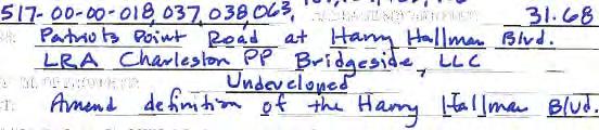
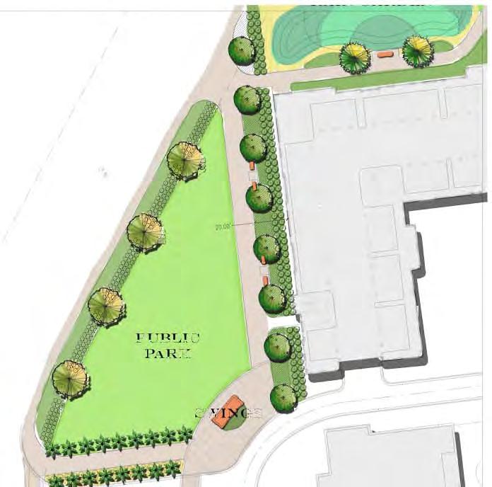
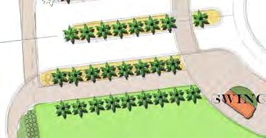
12 Planning Commission June 19, 2013 Page 9 of 10 Mr. Neal closed the public hearing. Mr. Richardson asked if the items should be voted on separately. Mr. Pagliarini answered in the affirmative. Mr. Richardson moved for approval of the amendment to the planned development as presented including all staff comments. Mr. Middleton seconded the motion. Mr. Richardson suggested that the requested height is not as dramatic as it first appeared particularly with the development of Central Mount Pleasant and suggested that the request is an appropriate use. He stated that it will still require design review approval and has confidence in staff. Mr. Neal called for a vote on the motion. All in favor. Mr. Richardson moved for approval of the impact assessment and conceptual plan with all staff comments and exploration of further traffic data to include construction of a roundabout or mini-roundabout. Ms. Woods- Flowers seconded the motion. Mr. Chapman moved to amend the motion to include the construction of bus shelters on Hungryneck Boulevard and Market Center Boulevard. Ms. Richter-Lehrman seconded the motion. All in favor. Mr. Neal called for a vote on the amended motion. All in favor. D. PLANNED DEVELOPMENT AMENDMENT REQUEST PUBLIC HEARING: Request to amend the Bridgeside II Planned Development District ordinance (Ord. No ) to allow for a modification of the build-to line requirement along Harry M. Hallman, Jr. Boulevard, specifically to allow for consideration of a building setback when public open spaces abut the street. This amendment applies to those portions of an approximately acre tract of land that abut Harry M. Hallman, Jr. Boulevard, which are located near the intersection of Patriots Point and Harry M. Hallman, Jr. Boulevards and are identified by TMS Nos , , , , , , , and Ms. Cousino reviewed staff comments as follows: This request specifically pertains to build to lines and building setbacks along Harry M. Hallman Jr. Blvd. Currently the Bridgeside planned development ordinance requires a 20 to 30 foot build to line along Harry M. Hallman, Jr. Blvd. The purpose of the build to line is to achieve a strong relationship between the street, pedestrian areas, and buildings similar to the concept of the activity zone in the Urban Corridor Overlay District. With the building layout that was shown on the original concept plan for this development, the 20 to 30 foot build to line could be accomplished. As development plans are being refined and the buildings designed, it has become challenging to accomplish the 20 to 30 foot build to line, especially with the curvature of the road. The developer is now contemplating a public park area in between Hallman Blvd. and the buildings where the road curves. This necessitates a revision to the planned
13 Planning Commission June 19, 2013 Page 10 of 10 development ordinance to allow a setback rather than the requirement to build to the street. The text amendment proposed by the developer is as follows: o Define the Harry Hallman Blvd. build-to line as follows: build-to line shall be measured from the building to the back of curb. Where public open spaces abut the street, buildings may be set back to create a public realm as determined through the Design Review process. It is important to clarify further the intent of this request so that the build to line and building setback for public open space is appropriately applied along other portions of the boulevard. Where a public open space is created in between the street and the building, no parking shall be permitted and the open space area should be enhanced in a manner to make it clear that it is an area for use by the general public. An illustrative site plan has been provided solely for the purpose of illustrating the concept of the public open space setback. Mr. Brimmer asked if this request is an effort to resolve a problem. Ms. Cousino answered in the affirmative and stated that this would be to provide public open space along the right-ofway. Mr. Whiteside reviewed the request with the Commission. Mr. Chapman asked if there would be more open space behind the buildings. Mr. Whiteside answered in the affirmative. Mr. Neal closed the public hearing. Mr. Brimmer asked how this would affect the overall design concept for the area. Ms. Cousino answered that this is not zoned Waterfront Gateway, but the property on both sides of Harry Hallman are included in this planned development. She stated that it would still accomplish the goal of public open space. She stated that it would require design review approval as well. She stated that many of the Waterfront Gateway elements were included in the planned development. Ms. Woods-Flowers moved for approval of the request. Ms. Richter-Lehrman seconded the motion. All in favor. There being no further business, the meeting adjourned at 6:29 p.m. Submitted by, L. Lynes PlanComsn
14 1 of 2 5/23/2013 8:36 AM Planning Commission Application ALL APPLICATIONS ARE DUE BY 11:59 p.m. ON THE DEADLINE DATES. It is highly recommended that the property owner and/or their representative meet with staff prior to submitting an application. Nature of Request & Fees Check all that apply:* Rezoning Planned Development Amendment Comprehensive Plan Amendment Impact Assessment & Conceptual Plan Sketch Plan Preliminary Plat Other Fee Schedule: For areas greater than acres the fee is $400 + $2 per additional acre. Please select the appropriate fee below and if over acres please enter acreage amount over acres in the quantity field below:* 0-5 Acres - $ acres Quantity (total acreage - 100)= Requirements All supplemental information must be scaled to 8 ½ x 11 sheets and submitted in a portable digital format (pdf) with this application and appropriate fee. The following supplemental information is included with this application(please list):* Subject Property / Properties Information TMS #:* Address:* Owner:* Present Use of Property:* Acreage / Sq. Feet:* Request:* Comprehensive Plan Amendment (only fill out if Comprehensive Plan Amendment requested) Present Comprehensive Plan Land Use Designation: Proposed Comprehensive Plan Land Use Designation: Description of Proposed Structure and Use of Property: Applicant Information Name:* Address:* Phone:* *
15 2 of 2 5/23/2013 8:36 AM Please attach supplemental information outlined above: Convert to PDF? (GIF, JPG, JPEG, PNG, DOC, DOCX, XLS, XLSX, TXT) I, the undersigned, serve as the owner or owner's representative and certify the information contained herein to be true and accurate. If an application is found to be incomplete, the primary contact will be notified and the application will be removed from the agenda. I further certify that the tract(s) or parcel(s) of land to which this approval request pertains: * is restricted is not restricted by any recorded covenant that is contrary to, conflicts with, or prohibits the activity for which approval is sought as provided in SC Code of Laws Section , and the Town of Mount Pleasant Code of Ordinances and I agree that all terms and information are true to my knowledge:* I agree Information of person completing electronic signature: Name:* Address (if different from above): (if different from above): Phone (if different from above): * indicates required fields.

16
17


18

19
20 1 of 2 5/23/2013 8:37 AM Planning Commission Application ALL APPLICATIONS ARE DUE BY 11:59 p.m. ON THE DEADLINE DATES. It is highly recommended that the property owner and/or their representative meet with staff prior to submitting an application. Nature of Request & Fees Check all that apply:* Rezoning Planned Development Amendment Comprehensive Plan Amendment Impact Assessment & Conceptual Plan Sketch Plan Preliminary Plat Other Fee Schedule: For areas greater than acres the fee is $400 + $2 per additional acre. Please select the appropriate fee below and if over acres please enter acreage amount over acres in the quantity field below:* 0-5 Acres - $ acres Quantity (total acreage - 100)= Requirements All supplemental information must be scaled to 8 ½ x 11 sheets and submitted in a portable digital format (pdf) with this application and appropriate fee. The following supplemental information is included with this application(please list):* Subject Property / Properties Information TMS #:* Address:* Acreage / Sq. Feet:* Owner:* Present Use of Property:* Request:* Comprehensive Plan Amendment (only fill out if Comprehensive Plan Amendment requested) Present Comprehensive Plan Land Use Designation: Proposed Comprehensive Plan Land Use Designation: Description of Proposed Structure and Use of Property: Applicant Information Name:* Address:* Phone:* *
21 2 of 2 5/23/2013 8:37 AM Please attach supplemental information outlined above: Towne Centre DIA-PD combined for submittal.pdf I, the undersigned, serve as the owner or owner's representative and certify the information contained herein to be true and accurate. If an application is found to be incomplete, the primary contact will be notified and the application will be removed from the agenda. I further certify that the tract(s) or parcel(s) of land to which this approval request pertains: * is restricted is not restricted by any recorded covenant that is contrary to, conflicts with, or prohibits the activity for which approval is sought as provided in SC Code of Laws Section , and the Town of Mount Pleasant Code of Ordinances and I agree that all terms and information are true to my knowledge:* I agree Information of person completing electronic signature: Name:* Address (if different from above): (if different from above): Phone (if different from above): * indicates required fields.
22 May 22, 2013 Planning Commission Submittal An Update to the Development Impact Assessment for Towne Centre (formerly known as The Market Center ) Mount Pleasant, South Carolina Date: May 22, 2013 (Planning Commission Submittal) Owner: IMI Mount Pleasant, LLC Designed by: Seamon, Whiteside and Associates, Inc. 501 Wando Park Blvd., Suite 200 Mount Pleasant, South Carolina Ph. (843)
23 May 22, 2013 Planning Commission Submittal TABLE OF CONTENTS PAGE I. General Description... 3 II. Impact Assessment A. Wastewater... 4 B. Water Supply... 4 C. Telephone and Power... 4 D. Solid Wastes... 4 E. Transportation... 4 F. Drainage... 5 G. Recreation... 5 H. Education... 5 I. Police... 5 J. Fire Protection... 5 K. Environmental Resources... 6 L. Cultural and Archaeological Resources... 6 M. Fiscal Considerations... 6 N. Housing... 6 O. Mt. Pleasant Comprehensive Plan... 6 III. Appendices 1. Charleston County Tax Map 2. Conceptual Plan 3. Master Drainage Plan 4. Master Sewer and Water Plan 5. Traffic Impact Analysis prepared by SRS Engineering, LLC 6. Proof of Coordination Letter a. Town of Mt. Pleasant Fire Department 2
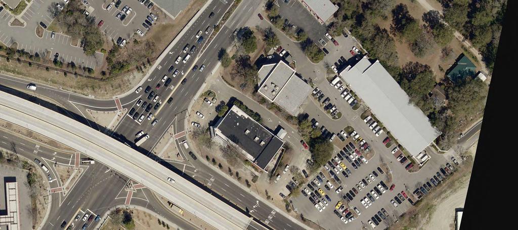
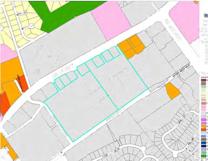
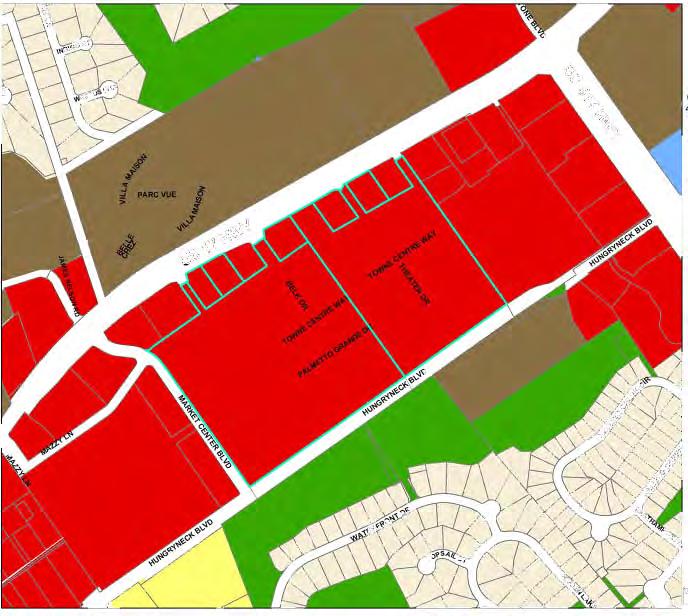
24 Development Impact Assessment (UPDATE) for TOWNE CENTRE Mount Pleasant, South Carolina May 22, 2013 Planning Commission Submittal I. GENERAL DESCRIPTION OF PROPOSED PROJECT Towne Centre proper, located on approximately 42 acres and fronting U.S. Hwy. 17 North, Hungryneck Boulevard and east of Market Center Boulevard (TMS Nos , -098, - 100, -340, -387, -399, and -406, as shown in Appendix No. 1) received its initial approval in 1995, and its only amendment in Existing uses within the development include a mixture of retail and office space as well as the Palmetto Grande Theater. The Centre has become one of the most popular gathering places in the Town of Mount Pleasant, and it is for that reason that IMI Mount Pleasant, LLC, the Owner and Developer, wishes to amend the development to include additional complementary uses. Proposed new uses within Towne Center proper, located on 42 acres east of Market Centre Boulevard, include: A maximum of 61,000 square feet of additional retail (net additional, accounts for loss of 5362 sf removed for Belk expansion) A 100-room, 6-story Hotel (55,000 sf) A 4-level Parking Garage These improvements are shown on the attached Conceptual Plan (see Appendix No. 2). Parking: Parking facilities for the development will meet Town of Mount Pleasant requirements for shopping centers and hotels. Outparcels shall be calculated separately as per their use. It is expected that during the construction of the parking garage, there will be a shortfall of parking spaces. Conversely, upon completion of this structure, there may be a slight overage of spaces, and therefore it is requested that any spaces beyond that quantity required for the center be permitted to be paved. Phasing: The initial phase of construction for this project is expected to begin January 2014 and be composed of approximately 36,000 sf of retail, including the Belk expansion, and ground floor of the hotel, 100-room hotel and initial phase (500 spaces) of the parking garage. Completion of these improvements is expected for October Subsequent expansion of retail will follow as market dictates with the completion of the parking garage to meet the parking requirements. Total Area Affected by Proposed Expansion: Approx. 3 Acres (Total Site = 42 Acres) 3
25 May 22, 2013 Planning Commission Submittal II. IMPACT ASSESMENT Note: The following Impact Assessment fees are based upon 61,000 sf of net additional retail area and a 100-room hotel. A. Wastewater The projected average daily wastewater to be generated by the new development is calculated as follows: LAND USE QUANTITY WASTEWATER GENERATION RATIO WASTEWATER GENERATED (GPD) Shopping Center 61,000 sf total 200 gpd/1,000 sf 12,200 gpd Hotel 100 Rooms 100 gpd/ Room 10,000 gpd This is the equivalent of 74 REU s (Residential Equivalent Units, one REU equates to 300 gpd). Based on the current impact fee structure of $4, per REU, this development will generate $333,000.00in sewer impact fees. Sewer service is available from the existing mains located on the property. A schematic Master Sewer Plan is attached (see Appendix No. 4) and is hereby made a part of this Development Impact Assessment. All sewer main construction shall be in accordance with Mt. Pleasant Waterworks requirements, and the system will be deeded to Mt. Pleasant Waterworks for ownership and maintenance upon completion and acceptance. B. Water Supply The projected average daily water demand for the additional retail and hotel is 74 REU s, same as the wastewater generation. Based on the current impact fee structure of $2, per REU, this development will generate water impact fees in the amount of $148, Water service is available from existing mains located on the property. Additional fire hydrants will be located throughout the project as necessary to provide adequate coverage to all portions of the development. A schematic Master Water Plan is attached (see Appendix No. 4) and is hereby made a part of this Development Impact Assessment. The system will be deeded to Mt. Pleasant Waterworks for ownership and maintenance upon completion and acceptance. C. Telephone, Power, and Cable Television South Carolina Electric and Gas Company, AT&T, and Comcast Cable will be will be providing extensions of power, telephone, and cable services, respectively, to the project from existing lines already provided within the center. D. Solid Wastes 4
26 May 22, 2013 Planning Commission Submittal Solid wastes generated by the development will be collected at planned refuse receptacle locations by a private collection company. Therefore, there will be no impact to the Public Works Department of the Town of Mount Pleasant. The development will generate $10, in Public Services Fees based on $0.09/s.f. for retail and hotel uses. E. Transportation A Traffic Impact Analysis has been prepared by SRS Engineering for the project, addressing access to the development, existing and proposed traffic volumes and distributions, and the effects of the project on the adjacent roadways (see Appendix No. 5.). Based on the Town s current impact fee structure, this development will generate $262, in transportation impact fees, based on the following: LAND USE SIZE IMPACT FEE RATE IMPACT FEE Shopping Center 61,000 sf $2.84/sf $173, Hotel 100 Rooms $892.98/ Room $89, F. Drainage Drainage for the shopping center is currently routed through existing water quality structures then to underground detention facilities and surface ponds before leaving the site. The proposed improvements will be located on current impervious areas, therefore additional detention will not be required. Should the existing stormwater detention pond located at Hungryneck Boulevard and Market Center Boulevard be replaced by surface parking, it will be converted with an underground detention product to provide adequate storage as needed to mitigate the loss of the storage provided by the pond. A schematic Master Drainage Plan is attached and is hereby made a part of this Development Impact Assessment (see Appendix No.3.) The drainage facilities design for the development must be approved by the Town of Mount Pleasant and SCDHEC-OCRM. All construction must be in accordance with Chapter 155 of the Town of Mount Pleasant Land Development Regulations. Building and siting specifications shall comply with Federal Flood Insurance Regulations. G. Recreation As this is a commercial development which will not add to the population of Mount Pleasant or to the use of existing facilities, there will be no impact to Town recreational facilities. H. Education As this is a commercial development which will not add to the population of Mount Pleasant or to the use of existing facilities, there will be no impact to the Charleston County School District. I. Police 5
27 May 22, 2013 Planning Commission Submittal The Mount Pleasant Police Department will provide police protection for this development. Taxes and fees generated from this development and its residents will fund any required additional personnel, as well as any equipment, facilities, etc. added. Based on the current Municipal Services Impact Fee for police service, this project will generate $13, in fees. J. Fire Protection The development will be served by an existing fire station located on Six Mile Road. It is possible that the project would require additional personnel or equipment. However, impact fees and taxes generated by the development will fund these costs. The fire department portion of the Municipal Impact Fees total $22, for this development. A Proof of Coordination letter was obtained from the Mount Pleasant Fire Department (see Appendix No. 6). K. Environmental Resources The area in question is currently fully constructed as the Towne Centre shopping center, including building structures, parking and above and below grade stormwater detention. Treesave areas are located in appropriate areas and will not be affected with the proposed expansion. L. Cultural and Archaeological Resources It is not anticipated that this tract possesses potential to contain significant cultural resources, as the site is currently completely constructed. Any site that may be discovered during construction, however, will be recovered, catalogued, mitigated, and preserved. M. Fiscal Considerations The development of this project should broaden the tax base of both the Town of Mount Pleasant and Charleston County. Based on the current rate structure, and an estimated investment of $18,000, in improvements, the shopping center will generate $41, and $194, in annual property taxes for the Town of Mount Pleasant and Charleston County, respectively. In addition, the 116,000 square feet of improvements (including 100-room hotel) will generate $794, in development impact fees to the Town of Mount Pleasant and Mount Pleasant Waterworks Building permit fees and plan review fees are expected to total $60, and $30,000.00, respectively for this overall project A summary of the previously described impact fees to be generated by the development is as follows: FEE 116,000 SF RETAIL/SHOPPING CENTER (SF INCL. 100-ROOM HOTEL) Sewer Impact Fees $333, Water Impact Fees $148, Municipal Services Impact Fees $51, Traffic Impact Fees $262, Total $794,
28 May 22, 2013 Planning Commission Submittal N. Housing As this is a commercial development, it will not add to the population of Mount Pleasant. O. Mt. Pleasant Comprehensive Plan The proposed development is located within the Commercial zoning designation of the Town s Comprehensive Plan. Towne Centre is currently an extremely popular office/retail shopping center with existing infrastructure and transportation improvements, meeting the stated Comp Plan strategy by promoting more intense, mixed use development in targeted corridors and nodes where there is sufficient infrastructure to support it. Through these improvements, Towne Centre is additionally working to promote the growth of existing businesses and recruitment of new businesses that are compatible with the Town s future vision, including that which promotes tourism and tourism-related industries and services. Further, other following goals and strategies are addressed: Implement the Town s Tourism Plan: Land Use: o Provides a hotel use in an area which provides ease of access to the Isle of Palms and the IOP Connector. o Creating denser development closer to the US 17 corridor where there is greater transportation infrastructure. o Encourages development of infill properties with appropriately scaled redevelopment to utilize infrastructure already in place. Transportation o This site is currently located along a CARTA route, thus promoting alternative transportation options. 7
29 Appendices
30 Charleston County Tax Map (TMS Nos , -098, -100, -340, -387, -399, and -406)


31
32 Conceptual Plan
33 PARKING DECK EXPANSION (AS NEEDED) 500 SPACE PARKING DECK HUNGRYNECK BOULEVARD POSSIBLE EXPANDED PARKING (UNDERGROUND DETENTION) FUTURE EXPANSION (SHADED TYP.) BELK EXPANSION 23,320 SF THEATER DRIVE FIRE LANE & UTILITY CORRIDOR BELK DEPARTMENT STORE NEW RETAIL EXIST. 81,675 SF 10,000 SF W/ 100 ROOM HOTEL ABOVE EX. RETAIL REMOVED FOR EXPANSION 5,362 SF NEW RETAIL 2,900 SF BELK MEN'S STORE 26,640 SF THEATER FUTURE EXPANSION (SHADED TYP.) BARNES & NOBLE OLD NAVY BED BATH & BEYOND MARKET CENTER BOULEVARD FUTURE EXPANSION (SHADED TYP.) FUTURE EXPANSION (SHADED TYP.) OWNED BY OTHERS OWNED BY OTHERS OWNED BY OTHERS OWNED BY OTHERS HIGHWAY 17 TOTAL NEW DEVELOPMENT POTENTIAL: 61,000 SF NET ADDITIONAL RETAIL 100 ROOM HOTEL
34 Master Drainage Plan
35 PARKING DECKS TO SPAN EXIST. UNDERGROUND DETENTION SYSTEM HUNGRYNECK BOULEVARD POSSIBLE EXPANDED PARKING (UNDERGROUND DETENTION) FUTURE EXPANSION (SHADED TYP.) THEATER DRIVE FIRE LANE & UTILITY CORRIDOR NEW BUILDING ROOF AND TOP DECK LEVEL ROUTED TO EX. DETENTION (TYP.) BELK DEPARTMENT STORE EXIST. 81,675 SF NEW DRAINAGE ROUTED TO EX. DETENTION (TYP.) BELK MEN'S STORE 26,640 SF THEATER FUTURE EXPANSION (SHADED TYP.) BARNES & NOBLE OLD NAVY BED BATH & BEYOND MARKET CENTER BOULEVARD FUTURE EXPANSION (SHADED TYP.) FUTURE EXPANSION (SHADED TYP.) OWNED BY OTHERS OWNED BY OTHERS OWNED BY OTHERS OWNED BY OTHERS HIGHWAY 17
36 Master Sewer and Water Plan
37 HUNGRYNECK BOULEVARD NEW WATER MAIN TO HUNGRYNECK BLVD. FUTURE EXPANSION (SHADED TYP.) BELK DEPARTMENT STORE EXIST. 81,675 SF THEATER DRIVE NEW SEWER MAIN TO HUNGRYNECK BLVD. FIRE LANE & UTILITY CORRIDOR BETWEEN STRUCTURES BELK MEN'S STORE 26,640 SF THEATER FUTURE EXPANSION (SHADED TYP.) BARNES & NOBLE OLD NAVY BED BATH & BEYOND MARKET CENTER BOULEVARD FUTURE EXPANSION (SHADED TYP.) FUTURE EXPANSION (SHADED TYP.) OWNED BY OTHERS OWNED BY OTHERS OWNED BY OTHERS OWNED BY OTHERS HIGHWAY 17
38 Traffic Impact Analysis
39 May 22, 2013 Mr. Clinton Dunn, P.E. Seamon Whiteside + Associates 501 Wando Park, Blvd. Suite 200 Mount Pleasant, SC SRS Engineering, LLC 801 Mohawk Drive West Columbia, SC (803) fax RE: Traffic Impact and Access Study Towne Center Expansion: Mount Pleasant, SC Dear Mr. Dunn: As requested, SRS Engineering, LLC (SRS) has completed an assessment of the traffic impacts associated with the proposed expansion of the existing Towne Center commercial development in Mount Pleasant, South Carolina. The following provides a summary of this study s findings: PROJECT DESCRIPTION Towne Center is located between US 17 and Hungryneck Boulevard, just south/west of the Isle of Palms Connector. Towne Center is a major existing retail center within the Town of Mount Pleasant that encompasses approximately 42-acres with 466,800 square-feet (sf) of existing retail development. Multiple existing access points are provided to US 17 and Hungryneck Boulevard. The current proposal is to develop additional retail space within Towne Center totaling approximately 61,000 sf (including a Belk expansion of 23,320 sf). Additionally a 116-room hotel is proposed along with a parking deck with 493 parking spaces. As scheduled, expansion is planned to be constructed and fully-constructed/operational by 2015 (2-year program). As planned, no new access points are proposed for the project; existing access drives to US 17 and Hungryneck Boulevard will be utilized. Figure 1, located in the Appendix of this report, graphically depicts the site location in relation to the local/regional roadway system. Figure 2, located in the Appendix of this report, graphically depicts the most up-to-date expansion plan as proposed. Todd E. Salvagin (803) Mike Ridgeway, P.E. (803) Matt Short, P.E. (803)
40 Mr. Clinton Dunn, P.E. May 22, 2013 Page 2 EXISTING CONDITIONS A comprehensive field inventory of the project study area was conducted in March/April The field inventory included a collection of geometric data, traffic volumes, and traffic control within the study area. The following nine (9) intersections were cited for study based on direction from Town of Mount Pleasant staff: US 17 at Market Center Blvd.; US 17 at Belk Drive; US 17 at Eastern Full-Movement Access (Unsignalized); US 17 at IOP Connector; IOP Connector at Hungryneck Blvd.; Hungryneck Blvd. at Market Center Blvd.; Hungryneck Blvd. at Belk Access Drive; Hungryneck Blvd. at Towne Center Access East; and Market Center Boulevard at Mazzy Lane (Internal Intersection). Figure 3, located in the Appendix of this report, graphically depicts the collected study area intersections geometric and traffic control characteristics. Traffic Volumes In order to determine the existing traffic volume flow patterns within the study area, manual turning movement counts were performed. Weekday morning (7:00-9:00 AM) and evening (4:00-6:00 PM) peak period turning movement specific count data was collected for above-referenced intersection. Figures 4 and 5, located in the Appendix of this report, graphically depict the respective AM and PM peak-hour traffic volumes at the study area intersections. Summarized count sheets for these intersections are included in the Appendix of this report. FUTURE CONDITIONS Traffic analyses for future conditions have been conducted for two separate scenarios: first, 2015 No- Build conditions, which include an annual normal growth in traffic, all pertinent background development traffic, and any pertinent planned roadway/intersection improvements; and secondly, 2015 Build conditions, which account for all No-Build conditions PLUS traffic generated by the proposed development. No-Build Traffic Conditions Annual Growth Rate Growth in the area was investigated via nearby SCDOT permanent count stations as well as growth rate information utilized in past reports. Based on this information, an annual growth rate of 1.5-percent per-year was developed for use in this report. This 1.5-percent annual growth rate, which would account for all unspecified traffic growth, was applied to the 2013 Existing peak-hour traffic volumes.
41 Mr. Clinton Dunn, P.E. May 22, 2013 Page 3 Background Development In accordance with information provided by Town of Mount Pleasant staff, no development projects exist which are currently approved and/or permitted and will cause an increase/change in traffic volume (in excess of normal annual volume growth) within the immediate study area. The anticipated 2015 No-Build AM and PM peak-hour traffic volumes, which reflect the 1.5-percent annual growth rate, are shown in Figures 6 and 7, which follow this report. Planned Roadway/Intersection Improvements As part of the Charleston County RoadWISE program, the Isle of Palms Connector will be widened to create a consistent four-lane divided facility from US 17 to Rifle Range Road. This will provide additional capacity for the intersection of the IOP Connector at Hungryneck Boulevard and IOP Connector at US 17 and has been accounted for in all future-year analyses. It should be noted that the widening of US 17 north of the Isle of Palms Connector was recently completed which has resulted in three through lanes for each approach of US 17 at this intersection. This improvement has been accounted for in all analyses. Site-Generated Traffic Traffic volumes expected to be generated by the proposed Towne Center expansion project was forecasted using the Eighth Edition of the ITE Trip Generation manual, as published by the Institute of Transportation Engineers. Comparisons of existing and proposed square footage for Land-Use Code #820 (Shopping Center) were used to estimate the additional shopping center traffic. The hotel was analyzed separately to present a conservative analysis. Table 1 depicts the anticipated site-generated traffic. Existing Table 1 PROJECT TRIP-GENERATION SUMMARY 1 Towne Center Expansion: Mount Pleasant, SC After Expansion 466,800 SF 527,800 SF Additional 35% Pass-By New Total Shopping Shopping Shopping Center New Shopping Shopping Center 116 Room 20% Int. Capture New External Center 2 Center 2 Trips Trips Only 3 Trips Hotel 4 Hotel Trips Only 5 Trips Time Period (a) (b) (b-a) (c) (b-a) - c (d) (e) (b-a) - c + d - e Weekday Daily 18,490 20,020 1,530 (536) (190) 1,754 AM Peak-Hour Enter (6) 42 Exit (4) 26 Total (10) 68 PM Peak-Hour Enter (27) (7) 77 Exit (27) (6) 77 Total 1,786 1, (54) (13) ITE Trip Generation manual, Eighth Edition. 2. ITE Trip Generation manual - LUC 820 (Shopping Center) % Pass-By for New Shopping Trips. Not applied for AM Peak Hour. 4. ITE Trip Generation manual - LUC 310 (Hotel) % Internal Capture Taken from Hotel Trips Only to account for interaction with shopping center. As shown, the additional development within Towne Center can be expected to generate a total of 1,754 new external two-way vehicular trips on a weekday daily basis, of which a total of 68 new external trips (42 entering, 26 exiting) can be expected during the AM peak-hour. During the PM peak-hour, 154 new external trips (77 entering, 77 exiting) can be expected.
42 Mr. Clinton Dunn, P.E. May 22, 2013 Page 4 The reported new external trips account for pass-by and internal capture reductions. A pass-by percentage of 35% was developed for the PM peak hour only and approved by Town staff. These are trips that are already traveling US 17 or Hungryneck Boulevard that will stop by Towne Center. These trips show up as additions entering and exiting the development, but as a subtraction from the corresponding through movements. A small percentage (20-percent) of the hotel trips were reduced from the total trips to account for interaction between the hotel and the shopping center. An example of this is someone that stays at the hotel and visits a restaurant or store within Towne Center. Distribution Pattern The directional distribution of site-generated traffic on the study area roadways has been based on an evaluation of existing travel patterns within the study area and was submitted and approved by Town of Mount Pleasant staff. This general distribution pattern is shown in Table 2. This distribution pattern has been applied to the site-generated traffic volumes from Table 1 to develop the site-generated specific volumes for the study area intersections illustrated in Figures 8 and 9, which follow this report. Table 2 TRIP DISTRIBUTION PATTERN Towne Center Expansion: Mount Pleasant, SC Roadways Direction To/From Percent of Trips Enter/Exit US 17 North 25 South 40 Hungryneck Blvd. North 5 South 20 Isle of Palms Connector West 10 Total 100 Build Traffic Conditions The site-generated traffic volumes, as depicted in Figures 8 & 9, have been added to the respective 2015 No-Build traffic volumes (Figures 6 & 7). This results in peak-hour Build traffic volumes, which are graphically depicted in Figures 10 and 11. These volumes were used as the basis to determine potential improvement measures necessary to mitigate traffic impacts caused by the project. TRAFFIC OPERATIONS Analysis Methodology A primary result of capacity analysis is the assignment of Level-of-Service (LOS) to traffic facilities under various traffic flow conditions. The concept of Level-of-Service is defined as a qualitative measure describing operational conditions within a traffic stream and their perception by motorists and/or passengers. A Level-of-Service designation provides an index to the quality of traffic flow in terms of such factors as speed, travel time, freedom to maneuver, traffic interruptions, comfort, convenience, and safety.
43 Mr. Clinton Dunn, P.E. May 22, 2013 Page 5 Six Levels-of-Service are defined for each type of facility (signalized and unsignalized intersections). They are given letter designations from A to F, with LOS A representing the best operating conditions and LOS F the worst. Since the Level-of-Service of a traffic facility is a function of the traffic flows placed upon it, such a facility may operate at a wide range of Levels-of-Service depending on the time of day, day of week, or period of a year. Analysis Results As part of this traffic study, capacity analyses have been performed at each study area intersection under both Existing and Future (No-Build & Build) conditions. The results of these analyses are summarized in Table 3. It should be noted that the traffic signals along US 17 are currently running Adaptive Control to maximize efficiency along the corridor. For analyses purposes, cycle lengths and splits were optimized for the three signals along US 17 during each peak hour. A common cycle length was utilized for the intersections for each peak hour which produced 100 second and 110 second cycles respectively for the AM and PM peak hours. Table 3 LEVEL-OF-SERVICE SUMMARY STUDY AREA INTERSECTIONS Towne Center Expansion: Mount Pleasant, SC Time 2013 EXISTING 2015 NO-BUILD 2015 BUILD Study Area Signalized Intersections Period V/C a Delay b LOS c V/C Delay LOS V/C Delay LOS US 17 at James Nelson Road/Market Center AM B B B Boulevard PM B B B US 17 at Belk Drive AM A B B PM B B B US 17 at The Isle of Palms Connector AM C C C PM C C C Hungryneck Boulevard at The Isle of Palms AM B B B Connector PM B B B Hungryneck Boulevard at Market Center AM A A A Boulevard PM A A A Study Area Unsignalized Intersections US 17 at Towne Center Eastern AM 17.8 C 18.4 C 18.4 C Full-Movement Access PM 61.3 F 72.4 F 81.8 F Hungryneck Boulevard at Towne Center AM 12.3 B 12.5 B 12.6 B Eastern Full-Movement Access PM 15.6 C 16.1 B 16.3 C Hungryneck Boulevard at Belk Access AM 14.8 B 15.2 C 15.8 C PM 26.7 D 28.2 D 29.7 D Market Center Boulevard at Mazzy Lane AM 11.2 B 11.3 B 11.6 B Internal Intersection PM 20.5 C 21.8 C 28.6 D a. Volume-to-Capacity ratio. b. Delay in seconds-per-vehicle. c. LOS = Level-of-Service. GENERAL NOTES: 1. For signalized intersections, Delay is representative of overall intersection. 2. For unsignalized intersections, Delay is representative of critical movement/approach. As shown in Table 3, under Existing 2013 traffic volume conditions, all study area intersections operate at acceptable overall service levels during each of the time periods studied with the exception of the US 17 at Towne Center eastern full-movement access which operates poorly during the PM peak-hour. The poor operations at this location are dictated by vehicles making left-turn movements onto US 17 at this
44 Mr. Clinton Dunn, P.E. May 22, 2013 Page 6 location, which is difficult during the PM peak hour due to very heavy volumes along US 17. While the volume of traffic attempting this maneuver is low (6 during the PM peak hour), the analysis indicates poor operations. Most traffic making left-turns out of Towne Center onto US 17 do so via the Belk Drive and Market Center Boulevard signalized intersections. Under 2015 No-Build conditions, which include the application of the cited 1.5-percent annual background growth rate indicate that all intersections will continue to operate acceptably with the exception of the unsignalized full-movement access to US 17 during the PM peak hour Build conditions, which account for the addition of site traffic associated with the Towne Center expansion, indicate that the expansion will overall have a minor impact on study area traffic operations. The center has multiple access drives (signalized and unsignalized) to US 17 and Hungryneck Boulevard, which allows for good dispersion of traffic volumes to multiple locations. The unsignalized fullmovement access to US 17 is expected to continue to operate with delays during the PM peak hour, however all other access points are expected to maintain acceptable operations. Queuing Analysis A review of critical queues has also been conducted as part of this traffic study. Queuing analysis sheets for Build conditions are provided in the Appendix of this report. Market Center Boulevard at Mazzy Lane (Internal Intersection): This intersection is critical to Towne Center in that is the first internal intersection that distributes traffic to/from US 17. This intersection is located approximately 270-feet internal of the site from US 17. The geometry for this intersection is somewhat unique due to the curve within Market Center Boulevard. Some motorists entering from US 17 were observed to be indecisive regarding turning or proceeding straight, however traffic did not back up and inhibit US 17 operations. Queues for exiting traffic from Market Center Boulevard onto US 17 were not observed to back up and block Mazzy Lane. This is confirmed in the Synchro queuing analyses for Build conditions. Isle of Palms Connector at Hungryneck Boulevard: The northbound left-turn movement from the Isle of Palms Connector onto Hungryneck Boulevard is significant during both peak periods (465 AM; 402 PM). Queuing analyses indicate that the queue exceeds provided storage during the PM peak hour; however there is significant spill back storage space available beyond the dedicated left-turn lane within the striped median, and therefore this is not considered a significant issue. MITIGATION The final phase of the analysis process is to identify mitigating measures which may either minimize the impact of the project on the transportation system or tend to alleviate poor service levels not caused by the project. Measures considered necessary to mitigate roadway system deficiencies are discussed below as they relate to the impacts of the proposed project. Proposed Site Access No new access points are proposed for Towne Center as part of the expansion. The center is well connected to US 17 and Hungryneck Boulevard, and the existing access points have been determined to be adequate to service the additional volumes related to the expansion. Consideration could be given to restricting/prohibiting left-turns out at the unsignalized full-movement access to US 17. This could be accomplished with striping/signage and would still allow for left-turns into Towne Center from the north/east, and right-turns out, but would force exiting left-turns to utilize
45 Mr. Clinton Dunn, P.E. May 22, 2013 Page 7 existing traffic signals at Belk Drive and Market Center Boulevard, which would improve safety and operations. This could also be done without impacting the full-movement access for the apartments on the opposite side of US 17. CONCLUSIONS This traffic study depicts existing and future traffic conditions based on a proposed retail expansion within Towne Center in Mount Pleasant, SC. As currently planned, 61,000 sf of additional retail space is proposed including a Belk expansion of 23,320 sf. Additionally a 116-room hotel is proposed along with a parking deck with 493 parking spaces. The expansion is expected to be completed in approximately two years (2015). No new access points are proposed for the expansion, and Towne Center will maintain existing access configurations to US 17 and Hungryneck Boulevard. Analyses have been completed for multiple intersections surrounding the Towne Center development. Traffic operations are generally favorable surrounding the development, and this is expected to continue with the proposed expansion of the site. There should be consideration to restricting exiting left-turns from the unsignalized access to US 17 (closest full-movement driveway to Isle of Palms Connector). This site has good access to exiting adjacent traffic signals, which would better serve left-turn movements destined towards Charleston. If you have any questions, please contact me at (803) Regards, SRS ENGINEERING, LLC Mike Ridgeway, P.E. Principal Attachments
46 APPENDIX Figures Note: Full Appendix Including Capacity Analyses, Traffic Counts, & Queuing Analyses Provided to Town Transportation Engineer.

47 SITE N NOT TO SCALE Figure 1 SITE LOCATION MAP Towne Center Expansion: Mount Pleasant, SC

48 Figure 2 PROPOSED SITE PLAN Towne Center Expansion: Mount Pleasant, SC
49
50
51
52
53
54
55
56
57
58 Proof of Coordination Letter


59 100 ANN EDWARDS LANE MT. PLEASANT, SC TEL (843) FAX (843) TOWNOFMOUNTPLEASANT.COM Fire Department May 17, 2013 Anna Lewis Seamon Whiteside & Associates 501 Wando Park Blvd. Mount Pleasant SC Dear Ms. Lewis, Re: Town Center Expansion I have reviewed the site plans for the above referenced project. The Town of Mount Pleasant Fire Department should be able to provide adequate fire protection for this project once our general requirements have been addressed. 1. Require compliance with all applicable sections of the International Building, Fire, Mechanical and Electrical Codes, the National Fire Protection Association fire codes and all Ordinances in effect in Mount Pleasant. You are reminded that at minimum your structure shall comply with type IIIB or better as detailed in the building code. Your building will be required to have an emergency electrical disconnect located on the exterior of the structure as detailed by code. 2. Fire Department requires proper access to facility and grounds for fire Suppression needs during construction. Roadways shall be capable of supporting fire apparatus of up to 36 ton and shall be so maintained. 3 Require fire hydrant(s) be located within 300 foot of facility of Mueller three-way type with a Storz main connection on minimum eight inch main. Hydrant(s) are required to be operational prior to construction and free of obstructions and decorative shrubbery. Adequate hydrants to be provided shall comply with fire flow requirements of the Insurance Services Office for the facility. The Calculated fire flow for your structure shall be 2100 GPMS, based upon size and type construction of the structure, as well as plans indicate the facility will be fully sprinklered. Code requires that a fire hydrant be located within 150 of the fire department connection. Primary protection for the proposed site is provided by the Town of Mount Pleasant Fire Department Station No. 4 located on Six Mile Road, with secondary protection provided
60 by Town of Mount Pleasant Fire Department Station No. 3 located on Mathis Ferry Road. Continuing growth could precipitate the need for additional apparatus, manning, and facilities. This letter is not intended to be construed as a plan review and/or acceptance of this project. The purpose of this correspondence is intended to confirm that we are aware of the project. Further it will indicate that the fire department can based upon the preliminary review of the site plans, fire protect same, however, only after a complete plan review has been completed and it is determined that the project is in complete compliance with all codes and ordinances in effect in the Town of Mount Pleasant. If we can be of any further assistance, please feel free to contact us. Sincerely, Dale A. Johnston Division Chief Fire Marshal Mount Pleasant Fire Department E mail djohnston@tompsc.com AWT: CC: Fire Inspection File
61 May 22, 2013 Planning Commission Submittal An Amendment to the Planned Development Guidelines for The Wilson Tract (also known as Towne Centre ) Mount Pleasant, South Carolina Date: May 22, 2013 (Planning Commission Submittal) Owner: IMI Mount Pleasant, LLC Designed by: Seamon, Whiteside and Associates, Inc. 501 Wando Park Blvd., Suite 200 Mount Pleasant, South Carolina Ph. (843)
62 May 22, 2013 Planning Commission Submittal TABLE OF CONTENTS PAGE I. General Description of the Proposed Project... 3 II. Existing Site Conditions... 4 III. Development Summary... 4 IV. Appendices 1. Charleston County Tax Map 2. Conceptual Plan 2
63 Planned Development Guidelines (AMENDMENT) for THE WILSON TRACT (aka TOWNE CENTRE) Mount Pleasant, South Carolina May 22, 2013 Planning Commission Submittal I. GENERAL DESCRIPTION OF PROPOSED PROJECT Towne Centre proper, located on approximately 42 acres and fronting U.S. Hwy. 17 North, Hungryneck Boulevard and east of Market Center Boulevard (TMS Nos , -098, - 100, -340, -387, -399, and -406, as shown in Attachment 1) received its initial approval in 1995, and its only amendment in Existing uses within the development include a mixture of retail and office space as well as the Palmetto Grande Theater. The Centre has become one of the most popular gathering places in the Town of Mount Pleasant, and it is for that reason that IMI Mount Pleasant, LLC, the Owner and Developer, wishes to amend the development to include additional complementary uses. Proposed new uses within Towne Center proper, located on 42 acres east of Market Centre Boulevard, include: A maximum of 61,000 square feet of additional retail A 100-room, 6-story Hotel A 4-level Parking Garage Additional retail space planned for the center is illustrated on the Sketch Plan (see Appendix 2), the majority of which is expected to occur primarily within two new stand-alone buildings and expansion of the Belk building. Residual additional space will be found throughout the center in various open spaces within and around existing retail shops. All new development proposed will be subject to the Town s Design Review process. The aforementioned hotel is planned near the Belk expansion, and along with its lobby, will include retail shops on its ground floor. Rooms for guests will be located on the second thru sixth floors, with the overall maximum height of the structure being 65 feet. A 4-level parking garage is planned adjacent to both the Belk addition and the hotel, with direct access into the latter. Lighting atop the 35-foot height structure (top of stairwell structure to be 42 feet) will be addressed through true-cutoff fixtures on 20-foot height poles. The garage, as it addresses its Hungryneck frontage, will be complementary to the streetscape and include appropriate design and plantings as directed through the Town s Design Review process. A site section through the garage and hotel that illustrates the structures relationships to the adjacent roadway and residential area is found in Appendix 3 of this report. As the majority of aforementioned uses will occur within already impervious areas, additional stormwater detention is expected to be minor. Should additional detention be necessary, it will be located underground in appropriate locations. Hungryneck Boulevard, which defines the eastern boundary of the site, provides a 5-lane divided roadway within a right-of-way of varying widths. Opposite the Centre along this tree- 3
64 II. May 22, 2013 Planning Commission Submittal lined road is located ponds, HOA open space and boat parking for the adjacent Sweetgrass and Hidden Lakes subdivisions. EXISTING CONDITIONS The area in question is currently fully constructed as the Towne Centre shopping center, including building structures, parking and above and below grade stormwater detention. Treesave areas are located in appropriate areas and will not be affected with the proposed expansion. No wetlands are located on the site. Elevations on the property range from Elev. 14 at the intersection of Market Center Boulevard and Hwy. 17, to Elev. 19 found further north along Hwy. 17, (with the exception of a detention pond located at the intersection of Hungryneck Boulevard and Market Center Boulevard). Total Affected Area: 42 Acres III. DEVELOPMENT SUMMARY: Building Area: (note: numbers shown do not include outparcels): Retail Use Hotel Use Existing 466,796 sf - Proposed 61,000 sf 100 rooms Total 527,796 sf 100 rooms Building Height (max.): Hotel: Parking Garage: All Other Structures: Setbacks: From Hungryneck Blvd.: All other areas: Buffers: 65 feet (6-story) 42 feet (stairwell structure only) 35 feet (surrounding parapet) 35 feet 10 feet (parking garage only) 24 feet (all other buildings) Unchanged 5 foot Roadside Buffer along Hungryneck Boulevard (10 foot Buffer provided where obtainable) All others remain unchanged from currently approved Parking: Parking facilities for the development will meet Town of Mount Pleasant requirements for shopping centers and hotels. Outparcels shall be calculated separately as per their use. It is expected that during the construction of the parking garage, there will be a shortfall of parking spaces. Conversely, upon completion of this structure, there may be a slight 4
65 May 22, 2013 Planning Commission Submittal overage of spaces, and therefore it is requested that any spaces beyond that quantity required for the center be permitted to be paved. Phasing: The initial phase of construction for this project is expected to begin January 2014 and be composed of approximately 36,000 sf of retail, including the Belk expansion, and ground floor of the hotel, 100-room hotel and initial phase (500 spaces) of the parking garage. Completion of these improvements is expected for October Subsequent expansion of retail will follow as market dictates with the completion of the parking garage to meet the parking requirements. 5
66 Appendices
67 Charleston County Tax Map (TMS Nos , -098, -100, -340, -387, -399, and -406)
68
69 Conceptual Plan
 FUTURE EXPANSION (SHADED TYP.")
70 PARKING DECK EXPANSION (AS NEEDED) 500 SPACE PARKING DECK REQUEST 10 FT. BUILDING SETBACK FOR PARKING DECK STRUCTURE ALONG HUNGRYNECK BLVD. HUNGRYNECK BOULEVARD POSSIBLE EXPANDED PARKING (UNDERGROUND DETENTION) FUTURE EXPANSION (SHADED TYP.) BELK EXPANSION 23,320 SF THEATER DRIVE FIRE LANE & UTILITY CORRIDOR NEW RETAIL BELK DEPARTMENT STORE 10,000 SF EXIST. 81,675 SF W/ 100 ROOM HOTEL ABOVE REQUEST 65 FT. BUILDING HEIGHT FOR HOTEL STRUCTURE NEW RETAIL 2,900 SF BELK MEN'S STORE 26,640 SF THEATER FUTURE EXPANSION (SHADED TYP.) BARNES & NOBLE OLD NAVY BED BATH & BEYOND MARKET CENTER BOULEVARD FUTURE EXPANSION (SHADED TYP.) FUTURE EXPANSION (SHADED TYP.) OWNED BY OTHERS OWNED BY OTHERS OWNED BY OTHERS OWNED BY OTHERS HIGHWAY 17 TOTAL NEW DEVELOPMENT POTENTIAL: 61,000 SF NET ADDITIONAL RETAIL 100 ROOM HOTEL

71

72

73
74
75


76

77


78


79
TOWN OF MOUNT PLEASANT, SOUTH CAROLINA PLANNING COMMISSION JUNE 19, 2013 MINUTES
 TOWN OF MOUNT PLEASANT, SOUTH CAROLINA PLANNING COMMISSION JUNE 19, 2013 MINUTES Present: Staff: Roy Neal, chair, Todd Richardson, Howard Chapman, Bob Brimmer, Henry Middleton, Alice Richter-Lehrman, Phil
SUBJECT PARCEL(S) Property Owner(s) TMS Number Approximate Acreage Carolina Park Development, LLC
 Property Owner(s) TMS Number Approximate Acreage Carolina Park Development, LLC") Staff Report Special Planning Commission Meeting November 19, 2014 For reference, the Zoning Code and Land Development Regulations are available online. AGENDA ITEM 5c. SKETCH PLAN APPROVAL REQUEST: Request
Staff Report Special Planning Commission Meeting November 19, 2014 For reference, the Zoning Code and Land Development Regulations are available online. AGENDA ITEM 5c. SKETCH PLAN APPROVAL REQUEST: Request
TOWN OF MOUNT PLEASANT, SOUTH CAROLINA PLANNING & DEVELOPMENT COMMITTEE OCTOBER 31, 2016 MINUTES. Municipal Complex, Building A, Public Meeting Room 1
 TOWN OF MOUNT PLEASANT, SOUTH CAROLINA PLANNING & DEVELOPMENT COMMITTEE OCTOBER 31, 2016 MINUTES Municipal Complex, Building A, Public Meeting Room 1 Members Present: Staff Present: Bob Brimmer, Joe Bustos,
STAFF REPORT 1311/1321 Chuck Dawley Boulevard
 AGENDA ITEM STAFF REPORT 1311/1321 Chuck Dawley Boulevard For reference, the Zoning Code and Land Development Regulations are available online. REZONING REQUEST PUBLIC HEARING: Request to rezone from R-1,
TOWN OF MOUNT PLEASANT, SOUTH CAROLINA PLANNING AND DEVELOPMENT COMMITTEE MAY 5, 2014 MINUTES. Municipal Complex - Council Chambers
 TOWN OF MOUNT PLEASANT, SOUTH CAROLINA PLANNING AND DEVELOPMENT COMMITTEE MAY 5, 2014 MINUTES Municipal Complex - Council Chambers Present: Staff: Thomasena Stokes-Marshall, Chair, Chris O'Neal, Elton
STAFF REPORT Cambridge Square at Park West (zoning request)
") STAFF REPORT Cambridge Square at Park West (zoning request) AGENDA ITEM For reference, the Zoning Code and Land Development Regulations are available online. PLANNED DEVELOPMENT DISTRICT AMENDMENT APPROVAL
STAFF REPORT Cambridge Square at Park West (zoning request) AGENDA ITEM For reference, the Zoning Code and Land Development Regulations are available online. PLANNED DEVELOPMENT DISTRICT AMENDMENT APPROVAL
PRIMUS TRACT MOUNT PLEASANT, SOUTH CAROLINA
 DEVELOPMENT GUIDELINES FOR PRIMUS TRACT MOUNT PLEASANT, SOUTH CAROLINA Date February 18, 2015 PLANNING COMMISSION SUBMITTAL Owner/Developer: American Star Development SC, LLC P.O. Box 211 Sullivans Island,
TOWN OF MOUNT PLEASANT, SOUTH CAROLINA PLANNING & DEVELOPMENT COMMITTEE APRIL 1, 2019 MINUTES. Municipal Complex, Committee Meeting Room
 TOWN OF MOUNT PLEASANT, SOUTH CAROLINA PLANNING & DEVELOPMENT COMMITTEE APRIL 1, 2019 MINUTES Municipal Complex, Committee Meeting Room Present: Staff: Joe Bustos, Chair, Bob Brimmer, Guang Ming Whitley,
R e z o n i n g A p p l i c a t i o n S u b m i s s i o n R e q u i r e m e n t s
 H O R R Y C O U N T Y P L A N N I N G & Z O N I N G 1 3 0 1 2 N D A V E., S U I T E 1 D - 0 9 C O N W A Y, S. C. 2 9 5 2 6 P H O N E : 8 4 3. 9 1 5. 5 3 4 0 F A X : 8 4 3. 9 1 5. 6 3 4 1 R e z o n i n
TOWN OF MOUNT PLEASANT, SOUTH CAROLINA COMMITTEES OF COUNCIL MEETINGS
 TOWN OF MOUNT PLEASANT, SOUTH CAROLINA COMMITTEES OF COUNCIL MEETINGS Municipal Complex Building A - Public Meeting Room 1 100 Ann Edwards Lane, Mount Pleasant, SC ************************** MONDAY, MARCH
Site Plan Application
 Site Plan Application City of St. Pete Beach Community Development Department 155 Corey Avenue St. Pete Beach, Florida 33706 (727) 367-2735 www.stpetebeach.org Case Number: PROPERTY OWNER: Name: Address:
PLANNED UNIT DEVELOPMENT & SUBDIVISION STAFF REPORT Date: April 18, 2019
 PLANNED UNIT DEVELOPMENT & SUBDIVISION STAFF REPORT Date: April 18, 2019 DEVELOPMENT NAME SUBDIVISION NAME Springhill Village Subdivision Springhill Village Subdivision LOCATION 4350, 4354, 4356, 4358,
Be linked by an internal circulation system (i.e., walkways, streets, etc.) to other structures within the IPUD;
 to other structures within the IPUD;") 2. HALIFAX ACTIVITY CENTER A. DESCRIPTIONS OF FUTURE LAND USE DESIGNATIONS Each of the future land use designations specified by Phase I of the Halifax Activity Center Plan, and the relationship of these
2. HALIFAX ACTIVITY CENTER A. DESCRIPTIONS OF FUTURE LAND USE DESIGNATIONS Each of the future land use designations specified by Phase I of the Halifax Activity Center Plan, and the relationship of these
APPLICANT NAME SUBDIVISION NAME DEVELOPMENT NAME LOCATION. CITY COUNCIL DISTRICT Council District 4 PRESENT ZONING PROPOSED ZONING
 SUBDIVISION, PLANNED UNIT DEVELOPMENT, PLANNING APPROVAL, ZONING AMENDMENT, & SIDEWALK WAIVER REQUEST STAFF REPORT Date: February 17, 2010 APPLICANT NAME SUBDIVISION NAME DEVELOPMENT NAME LOCATION David
Enclosed are amended PUD documents for The Grove at Shoal Creek Proposed by
 Enclosed are amended PUD documents for The Grove at Shoal Creek Proposed by The Bull Creek Road Coalition (BCRC) was formed in 2012 and is made up of residents in the six neighborhoods surrounding the
Staff Report Dunes West (Wood Park Drive & Highway 41) For reference, the Zoning Code and Land Development Regulations are available online.
 For reference, the Zoning Code and Land Development Regulations are available online.") AGENDA ITEM Staff Report Dunes West (Wood Park Drive & Highway 41) For reference, the Zoning Code and Land Development Regulations are available online. PLANNED DEVELOPMENT AMENDMENT REQUEST PUBLIC HEARING:
AGENDA ITEM Staff Report Dunes West (Wood Park Drive & Highway 41) For reference, the Zoning Code and Land Development Regulations are available online. PLANNED DEVELOPMENT AMENDMENT REQUEST PUBLIC HEARING:
TOWN OF MOUNT PLEASANT, SOUTH CAROLINA BOARD OF ZONING APPEALS JANUARY 26, 2015 MINUTES
 TOWN OF MOUNT PLEASANT, SOUTH CAROLINA BOARD OF ZONING APPEALS JANUARY 26, 2015 MINUTES Present: Absent: Staff: Mason Smith, Chair, Charles Moore, Jon Chalfie, Saila Milja-Smyly, Sy Rosenthal, Tripp Cuttino
SUBJECT: Application for Planned Unit Development and Rezoning 1725 Winnetka Road
 TO: FROM: CHAIRMAN BILL VASELOPULOS AND MEMBERS OF THE PLAN & ZONING COMMISSION STEVE GUTIERREZ DIRECTOR OF COMMUNITY DEVELOPMENT MEETING DATE: September 5, 2017 SUBJECT: Application for Planned Unit Development
CHECKLIST FOR DEVELOPMENT REVIEW
 CHECKLIST FOR DEVELOPMENT REVIEW Petitions and related documents and plans for land development or other proposals regulated by Title 16 of the Municipal Code (Development Ordinance) and Title 17 of the
TOWN OF MOUNT PLEASANT, SOUTH CAROLINA BOARD OF ZONING APPEALS APRIL 25, 2016 MINUTES
 TOWN OF MOUNT PLEASANT, SOUTH CAROLINA BOARD OF ZONING APPEALS APRIL 25, 2016 MINUTES Present: Staff: Mason Smith, Chair, Barbara Wagner, Glyn Cowden, Joseph Belton, Mark Lamb, Saila Milja-Smyly. Kelly
MIDDLETOWN TOWNSHIP PLANNING COMMISSION REGULAR MEETING MIDDLETOWN MUNICIPAL BUILDING WEDNESDAY, November 2, 2016
 MIDDLETOWN TOWNSHIP PLANNING COMMISSION REGULAR MEETING MIDDLETOWN MUNICIPAL BUILDING WEDNESDAY, November 2, 2016 PRESENT: ABSENT Sandy Farry George Hyjurick Charles Parkerson Fred Thomas Robert Burnet.
Staff Report: Date: Applicant: Property Identification: Acreage of Request: Current Zoning of Requested Area: Requested Action: Attached:
 Staff Report: Completed by Jeff Palmer Director of Planning & Zoning Date: November 7, 2018, Updated November 20, 2018 Applicant: Greg Smith, Oberer Land Developer agent for Ronald Montgomery ET AL Property
9. REZONING NO Vicinity of the northwest corner of 143 rd Street and Metcalf Avenue
 9. REZONING NO. 2002-15 Vicinity of the northwest corner of 143 rd Street and Metcalf Avenue 1. APPLICANT: Andrew Schlagel is the applicant for this request. 2. REQUESTED ACTION: The applicant is requesting
REZONING APPLICATION INSTRUCTIONS
 REZONING APPLICATION INSTRUCTIONS All required information, as stated on the Rezoning Application Checklist, must be included to qualify as a complete application. Upon receipt, staff will review the application
Level III Preliminary and Final Site Plans Development Review Application Portland, Maine Planning and Urban Development Department Planning Division
 Level III Preliminary and Final Site Plans Development Review Application Portland, Maine Planning and Urban Development Department Planning Division Portland s Planning and Urban Development Department
O-I (Office-Institutional) and AG-1(Agricultural)
 and AG-1(Agricultural)") PROPERTY INFORMATION ADDRESS 3503 and 3505 Bethany Bend DISTRICT, LAND LOTS 2/1 973 and 974 OVERLAY DISTRICT State Route 9 PETITION NUMBERS EXISTING ZONING O-I (Office-Institutional) and AG-1(Agricultural)
PROPERTY INFORMATION ADDRESS 3503 and 3505 Bethany Bend DISTRICT, LAND LOTS 2/1 973 and 974 OVERLAY DISTRICT State Route 9 PETITION NUMBERS EXISTING ZONING O-I (Office-Institutional) and AG-1(Agricultural)
Community Development
 Land Use Petition RZ-16-002 Date of Staff Recommendation Preparation: April 15, 2016 (CEL) Date of Planning Commission Recommendation: May 3, 2016 PROJECT LOCATION: DISTRICT/SECTION/LANDLOT(S): ACREAGE
SUBDIVISION, PLANNED UNIT DEVELOPMENT, PLANNING APPROVAL, ZONING AMENDMENT, & SIDEWALK WAIVER REQUEST STAFF REPORT Date: February 17, 2010
 SUBDIVISION, PLANNED UNIT DEVELOPMENT, PLANNING APPROVAL, ZONING AMENDMENT, & SIDEWALK WAIVER REQUEST STAFF REPORT Date: February 17, 2010 APPLICANT NAME SUBDIVISION NAME DEVELOPMENT NAME LOCATION David
Mount Airy Planning Commission March 26, Staff Report
 Mount Airy Planning Commission March 26, 2018 Staff Report Special Exception Request Mixed Use Development in CC District Recommendation to Board of Appeals CASE MA-A-18-01 Applicant: Location: Zoning:
City of Peachtree City. Annexation Review Process
 City of Peachtree City Annexation Review Process Page 1 Annexation Review Process Step One: Initial annexation information The following information is to be completed by the property owner and/ or their
SUBDIVISION APPLICATION CHECKLIST SKETCH PLAN PRELIMINARY PLAT FINAL PLAT
 RECEIVED STAMP SUBDIVISION APPLICATION CHECKLIST SKETCH PLAN PRELIMINARY PLAT FINAL PLAT A checklist of background information and submission requirements for processing of a sketch plan, preliminary plat
APPLICATION PROCEDURE
 ANTRIM PLANNING BOARD P. O. Box 517 Antrim, New Hampshire 03440 Phone: 603-588-6785 FAX: 603-588-2969 APPLICATION FORM AND CHECKLIST FOR MINOR OR MAJOR SITE PLAN REVIEW File Date Received By APPLICATION
II. What Type of Development Requires Site Plan Review? There are five situations where a site plan review is required:
 I. What is a Site Plan Review? Site Plan Review is a process where the construction of new buildings, new additions, and certain types of canopies and/or tax-exempt institutions are reviewed by the City
CONDOMINIUM REGULATIONS
 ARTICLE 37 CONDOMINIUM REGULATIONS SECTION 37.01. Purpose The purpose of this Article is to regulate projects that divide real property under a contractual arrangement known as a condominium. New and conversion
CITY OF OCOEE LAND DEVELOPMENT CODE SUFFICIENCY TABLE WITH NOTES
 CITY OF OCOEE LAND DEVELOPMENT CODE SUFFICIENCY TABLE WITH NOTES The Sufficiency Table is a checklist to help identify the types of information and documentation needed for various types of projects. The
ZONING AMENDMENT, PLANNED UNIT DEVELOPMENT & SUBDIVISION STAFF REPORT Date: August 8, 2013
 ZONING AMENDMENT, PLANNED UNIT DEVELOPMENT & SUBDIVISION STAFF REPORT Date: August 8, 2013 NAME SUBDIVISION NAME PV-Magnolia, LLC Twelve Trees Subdivision LOCATION 2860, 2862 and 2866 Pleasant Valley Road
M-43 CORRIDOR OVERLAY ZONE
 ARTICLE 26.00 M-43 CORRIDOR OVERLAY ZONE Section 26.01 Findings A primary function of the M-43 state highway is to move traffic through the Township and to points beyond. As the primary east-west arterial
CITY OF SPRINGDALE, OHIO SPRINGDALE BUILDING DEPARTMENT SPRINGFIELD PIKE SPRINGDALE, OHIO TELEPHONE: (513)
") CITY OF SPRINGDALE, OHIO SPRINGDALE BUILDING DEPARTMENT 11700 SPRINGFIELD PIKE SPRINGDALE, OHIO 45246 TELEPHONE: (513) 346-5730 SUBMISSION REQUIREMENTS AND INSTRUCTIONS FOR DEVELOPMENT PLAN APPROVAL An
CITY OF SPRINGDALE, OHIO SPRINGDALE BUILDING DEPARTMENT 11700 SPRINGFIELD PIKE SPRINGDALE, OHIO 45246 TELEPHONE: (513) 346-5730 SUBMISSION REQUIREMENTS AND INSTRUCTIONS FOR DEVELOPMENT PLAN APPROVAL An
Staff Report: Date: Applicant: Property Identification: Acreage of Request: Current Zoning of Requested Area: Requested Action: Attached:
 Staff Report: Completed by Jeff Palmer Director of Planning & Zoning Date: November 7, 2018 Applicant: Greg Smith, Oberer Land Developer agent for Ronald Montgomery ET AL Property Identification: Frontage
CITY OF SPRINGDALE, OHIO SPRINGDALE BUILDING DEPARTMENT SPRINGFIELD PIKE SPRINGDALE, OHIO TELEPHONE: (513)
") CITY OF SPRINGDALE, OHIO SPRINGDALE BUILDING DEPARTMENT 11700 SPRINGFIELD PIKE SPRINGDALE, OHIO 45246 TELEPHONE: (513) 346-5730 SUBMISSION REQUIREMENTS AND INSTRUCTIONS FOR FINAL PUD/TRANSITION DISTRICT
CITY OF SPRINGDALE, OHIO SPRINGDALE BUILDING DEPARTMENT 11700 SPRINGFIELD PIKE SPRINGDALE, OHIO 45246 TELEPHONE: (513) 346-5730 SUBMISSION REQUIREMENTS AND INSTRUCTIONS FOR FINAL PUD/TRANSITION DISTRICT
Section 1: US 19 Overlay District
 Section 1: US 19 Overlay District Section 1.1 Intent and Purpose The purpose of the US Highway 19 Overlay District is to manage access to land development along US Highway 19 in a manner that preserves
ARTICLE 143. PD 143.
 ARTICLE 143. PD 143. SEC. 51P-143.101. LEGISLATIVE HISTORY. PD 143 was established by Ordinance No. 17685, passed by the Dallas City Council on February 2, 1983. Ordinance No. 17685 amended Ordinance No.
Section 4 Master Plan Framework
 Section 4 Master Plan Framework 4.1 PURPOSE The Master Plan, as an implementation tool of the SPC District, establishes the primary framework for the overall development of the Property. Detailed site
EDGERTON CITY HALL PLANNING COMMISSION MEETING REGULAR SESSION March 12, 2019
 EDGERTON CITY HALL PLANNING COMMISSION MEETING REGULAR SESSION The met in regular session with Chair John Daley calling the meeting to order at 7:00 p.m. All present participated in the Pledge of Allegiance.
ZONING AMENDMENT & SUBDIVISION STAFF REPORT Date: June 18, 2015
 ZONING AMENDMENT & SUBDIVISION STAFF REPORT Date: June 18, 2015 APPLICANT NAME SUBDIVISION NAME EAA LLC / Eryka Rogers Aaiden Place Subdivision LOCATION 2480 Government Boulevard (North side of Government
McGowin Park, LLC. B-3, Community Business District
 # 10, 11, 12 SUB2014-00024 ZON2014-00500 ZON2014-00501 SUBDIVISION, PLANNED UNIT DEVELOPMENT (East), PLANNED UNIT DEVELOPMENT (West) STAFF REPORT Date: April 3, 2014 DEVELOPMENT NAME LOCATION McGowin Park,
Watertown City Council
 City of Watertown Watertown City Council 2/14/2017 Agenda Item: Riverpointe Subdivision 2 nd Replat Request for Action: Sketch Plan Department: Planning Request for Action Request: Paxmar, LLC (Applicant)
UPPER MOUNT BETHEL TOWNSHIP NORTHAMPTON COUNTY, PENNSYLVANIA
 UPPER MOUNT BETHEL TOWNSHIP NORTHAMPTON COUNTY, PENNSYLVANIA JOINDER DEED / LOT CONSOLIDATION TOWNSHIP REVIEW PROCESS When accepting proposed Joinder Deeds / Lot Consolidations, review the Joinder Deed
TOWN OF MOUNT PLEASANT, SOUTH CAROLINA COMMITTEES OF COUNCIL MEETINGS
 TOWN OF MOUNT PLEASANT, SOUTH CAROLINA COMMITTEES OF COUNCIL MEETINGS Municipal Complex Building A - Public Meeting Room 1 100 Ann Edwards Lane, Mount Pleasant, SC ************************** MONDAY, JANUARY
CITY OF SPRINGDALE, OHIO SPRINGDALE BUILDING DEPARTMENT SPRINGFIELD PIKE SPRINGDALE, OHIO TELEPHONE: (513)
") CITY OF SPRINGDALE, OHIO SPRINGDALE BUILDING DEPARTMENT 11700 SPRINGFIELD PIKE SPRINGDALE, OHIO 45246 TELEPHONE: (513) 346-5730 SUBMISSION REQUIREMENTS AND INSTRUCTIONS FOR MINOR REVISIONS TO PUD/TRANSITION
CITY OF SPRINGDALE, OHIO SPRINGDALE BUILDING DEPARTMENT 11700 SPRINGFIELD PIKE SPRINGDALE, OHIO 45246 TELEPHONE: (513) 346-5730 SUBMISSION REQUIREMENTS AND INSTRUCTIONS FOR MINOR REVISIONS TO PUD/TRANSITION
THE REDEVELOPMENT PLAN
 PAGE 37 THE REDEVELOPMENT PLAN FUTURE LAND USE The Silver Terrace Redevelopment Area is currently designated as Redevelopment Area #4 on the City of Delray Beach Future Land Use Map (FLUM). This designation
STAFF SUMMARY FOR Z18-09 CONDITIONAL ZONING DISTRICT APPLICATION
 STAFF SUMMARY FOR Z18-09 CONDITIONAL ZONING DISTRICT APPLICATION APPLICATION SUMMARY Case Number: Z18-09 Request: Conditional R-10 Zoning District in order to develop a performance residential development
The V Development Company, Inc. 297 E Paces Ferry Rd NE, Unit 1701 Atlanta, GA 30305
 4 of 40 40 of 40 The V Development Company, Inc. 297 E Paces Ferry Rd NE, Unit 1701 Atlanta, GA 30305 Letter of Intent The V Development Company desires to redevelop the property located at 4970, 4974,
Residential Major Subdivision Review Checklist
 Residential Major Subdivision Review Checklist Plan Submittal Requirements: 2 full sets of stamped plans Electric submittal - all plans contained in a single PDF 3 full sets if commercial kitchen or dining
Financial Impact Statement There are no immediate financial impacts associated with the adoption of this report.
 STAFF REPORT Planning and Development Department Subject: Application by RYC Property to rezone a portion of lands on John Murray Dr. and Megan Lynn Dr. from R2 to R3 and to enter into a Development Agreement
MASTER SUBDIVISION FINAL PLAT APPLICATION Town of Apex, North Carolina
 MASTER SUBDIVISION FINAL PLAT APPLICATION Town of Apex, North Carolina This document is a public record under the North Carolina Public Records Act and may be published to the Town s website or disclosed
BARROW COUNTY, GEORGIA
 BARROW COUNTY, GEORGIA Application For Rezoning, Special Use, and Change in Conditions BARROW COUNTY DEPARTMENT OF PLANNING AND DEVELOPMENT 30 North Broad Street Winder, Georgia 30680 770-307-3034 APPLICATION
Subdivision (Plat) Checklist
 Checklist") Subdivision (Plat) Checklist This Checklist is intended to assist you in preparing a complete application for submittal. Occasionally, additional items may be required to complete the review. Incomplete
Subdivision (Plat) Checklist This Checklist is intended to assist you in preparing a complete application for submittal. Occasionally, additional items may be required to complete the review. Incomplete
Contributing Authors:
 chapter 10 Site/Development Plan Review Contributing Authors: Jackie Turner, AICP, LEED AP and Robert Thompson, AICP - Current Authors Robert S. Cowell, Jr., AICP - Previous Author In this chapter... Introduction
CITY OF SPRINGDALE, OHIO SPRINGDALE BUILDING DEPARTMENT SPRINGFIELD PIKE SPRINGDALE, OHIO TELEPHONE: (513)
") CITY OF SPRINGDALE, OHIO SPRINGDALE BUILDING DEPARTMENT 11700 SPRINGFIELD PIKE SPRINGDALE, OHIO 45246 TELEPHONE: (513) 346-5730 SUBMISSION REQUIREMENTS AND INSTRUCTIONS FOR REVISIONS TO APPROVED DEVELOPMENT
CITY OF SPRINGDALE, OHIO SPRINGDALE BUILDING DEPARTMENT 11700 SPRINGFIELD PIKE SPRINGDALE, OHIO 45246 TELEPHONE: (513) 346-5730 SUBMISSION REQUIREMENTS AND INSTRUCTIONS FOR REVISIONS TO APPROVED DEVELOPMENT
ADDRESS / DESCRIPTION: Northeast corner of Sandbridge Road and Atwoodtown Road ELECTION DISTRICT: PRINCESS ANNE
 10 & 11 March 14, 2012 Public Hearing APPLICANT: MARLYN DEVELOPMENT CORPORATION PROPERTY OWNER: CORAL DEVELOPMENT, LLC STAFF PLANNER: Faith Christie REQUEST: Modification of Conditional Change of Zoning
PLANNED UNIT DEVELOPMENT (East), PLANNED UNIT DEVELOPMENT (West) STAFF REPORT Date: September 18, 2014
, PLANNED UNIT DEVELOPMENT (West) STAFF REPORT Date: September 18, 2014") PLANNED UNIT DEVELOPMENT (East), PLANNED UNIT DEVELOPMENT (West) STAFF REPORT Date: September 18, 2014 DEVELOPMENT NAME LOCATION McGowin Park, LLC PLANNED UNIT DEVELOPMENT (East) 1401 Satchel Paige Drive
PLANNED UNIT DEVELOPMENT (East), PLANNED UNIT DEVELOPMENT (West) STAFF REPORT Date: September 18, 2014 DEVELOPMENT NAME LOCATION McGowin Park, LLC PLANNED UNIT DEVELOPMENT (East) 1401 Satchel Paige Drive
(a) Commercial uses on Laurel Avenue, abutting the TRO District to the
 Commercial uses on Laurel Avenue, abutting the TRO District to the") 32X Zoning Code 150.36 TRANSITIONAL RESIDENTIAL OVERLAY DISTRICT. (A) Intent and purpose. (1) It is the intent of the Transitional Residential Overlay District (hereinafter referred to as the "TRO District")
32X Zoning Code 150.36 TRANSITIONAL RESIDENTIAL OVERLAY DISTRICT. (A) Intent and purpose. (1) It is the intent of the Transitional Residential Overlay District (hereinafter referred to as the "TRO District")
CHAPTER XVIII SITE PLAN REVIEW
 CHAPTER XVIII SITE PLAN REVIEW Section 18.1 Section 18.2 Description and Purpose. The purpose of this chapter is to provide standards and procedures under which applicants would submit, and the Township
Town of Bristol Rhode Island
 Town of Bristol Rhode Island Subdivision & Development Review Regulations Adopted by the Planning Board September 27, 1995 (March 2017) Formatted: Highlight Formatted: Font: 12 pt Table of Contents TABLE
Larimer County Planning Dept. Procedural Guide for 1041 PERMITS
 - Larimer County Planning Dept. Procedural Guide for 1041 PERMITS PLEASE NOTE: A PRE-APPLICATION CONFERENCE IS REQUIRED PRIOR TO SUBMITTING THIS APPLICATION. PURPOSE: State Statutes allow local governments
COMPREHENSIVE PLAN FUTURE LAND USE MAP AMENDMENT APPLICATION
 COUNTY STAFF DATA ONLY Date Received: Project No. CPA-20 - GADSDEN COUNTY DEPARTMENT OF PLANNING & COMMUNITY DEVELOPMENT 1-B East Jefferson Street, Post Office Box 1799, Quincy, FL 32353-1799 PLANNING
PLANNING COMMISSION REPORT Regular Agenda -Public Hearing Item
 PDP-13-00518 Item No. 3B- 1 PLANNING COMMISSION REPORT Regular Agenda -Public Hearing Item PC Staff Report 2/24/14 ITEM NO. 3B PRELIMINARY DEVELOPMENT PLAN FOR HERE @ KANSAS; 1101 INDIANA ST (SLD) PDP-13-00518:
ZONING AMENDMENT & SUBDIVISION STAFF REPORT Date: November 3, 2016
 ZONING AMENDMENT & SUBDIVISION STAFF REPORT Date: November 3, 2016 APPLICANT NAME SUBDIVISION NAME David Shumer 5955 Airport Subdivision CITY COUNCIL DISTRICT District 6 5955 Airport Boulevard, 754 Linlen
DAUPHIN CREEK ESTATES SUBDIVISION
 # 12 SUB-000076-2017 DAUPHIN CREEK ESTATES SUBDIVISION Engineering Comments: FINAL PLAT COMMENTS (should be addressed prior to submitting the FINAL PLAT for review and/or signature by the City Engineer):
CITY OF SPRINGDALE, OHIO SPRINGDALE BUILDING DEPARTMENT SPRINGFIELD PIKE SPRINGDALE, OHIO TELEPHONE: (513)
") CITY OF SPRINGDALE, OHIO SPRINGDALE BUILDING DEPARTMENT 11700 SPRINGFIELD PIKE SPRINGDALE, OHIO 45246 TELEPHONE: (513) 346-5730 SUBMISSION REQUIREMENTS AND INSTRUCTIONS FOR MAJOR CHANGE TO A PRELIMINARY
CITY OF SPRINGDALE, OHIO SPRINGDALE BUILDING DEPARTMENT 11700 SPRINGFIELD PIKE SPRINGDALE, OHIO 45246 TELEPHONE: (513) 346-5730 SUBMISSION REQUIREMENTS AND INSTRUCTIONS FOR MAJOR CHANGE TO A PRELIMINARY
Guide to Combined Preliminary and Final Plats
 Guide to Combined Preliminary and Final Plats Introduction The Douglas County is committed to providing open, transparent application processes to the public. This Guide is provided to assist anyone interested
ZRTD , Glenn Drive. M. Tyler Klein, AICP, Project Manager, Planning and Zoning John Merrithew, Acting Director, Planning and Zoning
 DEPARTMENT OF PLANNING Date of Hearing: AND ZONING STAFF REPORT # 4 BOARD OF SUPERVISORS PUBLIC HEARING SUBJECT: ELECTION DISTRICT: ZRTD-2014-0003, 22675 Glenn Drive Broad Run CRITICAL ACTION DATE: September
Report to the Plan Commission December 19, 2011
 Report to the Plan Commission Legistar I.D. #24825, Extraterritorial Certified Survey Map Requested Action: Consideration of a two-lot Certified Survey Map (CSM) of the Keryluk-Wee property located at,,
SECTION 16. "PUD" PLANNED UNIT DEVELOPMENT OVERLAY DISTRICT
 SECTION 6. "PUD" PLANNED UNIT DEVELOPMENT OVERLAY DISTRICT Subsection. Purpose. This district is established to achieve the coordinated integration of land parcels and large commercial and retail establishments
TOWN OF OCEAN ISLE BEACH
 TOWN OF OCEAN ISLE BEACH PLANNED UNIT DEVELOPMENT ORDINANCE ADOPTED IN EFFECT FEBRUARY 13, 2001 This ordinance has been prepared by the Ocean Isle Beach Planning & Inspections Department. Section 66-55.
PALM BEACH COUNTY PLANNING, ZONING AND BUILDING DEPARTMENT ZONING DIVISION
 PALM BEACH COUNTY PLANNING, ZONING AND BUILDING DEPARTMENT ZONING DIVISION Application No.: ZV/DOA-2012-03106 Application Name: Polo Club Shoppes Control No.: 1986-00090 Applicant: G & I VII Polo Club
31, Township 29 South, Range 25 East, Polk County, Florida, as depicted by the Land Use Plan attached
 ORDINANCE NO. 2013-04 AN ORDINANCE AMENDING THE ZONING MAP OF THE CITY OF BARTOW, FLORIDA, REZONING APPROXIMATELY 2. 2 ACRES OF LAND OWNED BY BALA3I OF POLK COUNTY, LLC AND LOCATED IN SECTION 31, TOWNSHIP
Condominium Unit Requirements.
 ARTICLE 19 CONDOMINIUM REGULATIONS Section 19.01 Purpose. The purpose of this Article is to regulate projects that divide real property under a contractual arrangement known as a condominium. New and conversion
SECTION SITE SURVEYS
 PART 1 - GENERAL 1.1 DESCRIPTION SECTION 02 21 00 SPEC WRITER NOTES: 1. Use this section only for NCA projects. 2. Delete between //---// if not applicable to project. Also delete any other item or paragraph
MINOR SUBDIVISION FINAL PLAT APPLICATION Town of Apex, North Carolina
 MINOR SUBDIVISION FINAL PLAT APPLICATION Town of Apex, North Carolina This document is a public record under the North Carolina Public Records Act and may be published on the Town s website or disclosed
STAFF SUMMARY OF Z17-10 CONDITIONAL ZONING DISTRICT APPLICATION
 STAFF SUMMARY OF Z17-10 CONDITIONAL ZONING DISTRICT APPLICATION APPLICATION SUMMARY Case Number: Z17-10 Request: Conditional B-2 Zoning District in order to expand an existing retail and warehousing business
619. Planned Development District (PD)
") 619. Planned Development District (PD) Intent. The purpose of the Planned Development District (sometimes hereinafter referred to as PD) is to provide opportunities to create more desirable environments
619. Planned Development District (PD) Intent. The purpose of the Planned Development District (sometimes hereinafter referred to as PD) is to provide opportunities to create more desirable environments
ARTICLE 50. PD 50. Unless otherwise stated, the definitions and interpretations in Chapter 51 apply to this
 ARTICLE 50. PD 50. SEC. 51P-50.101. LEGISLATIVE HISTORY. PD 50 was established by Ordinance No. 13428, passed by the Dallas City Council on November 8, 1971. Ordinance No. 13428 amended Ordinance No. 10962,
PALM BEACH COUNTY PLANNING, ZONING AND BUILDING DEPARTMENT ZONING DIVISION
 PALM BEACH COUNTY PLANNING, ZONING AND BUILDING DEPARTMENT ZONING DIVISION Application No.: CA-2012-00688 Control No.: 2011-00552 Applicant: Garry Bernardo Owners: Garry Bernardo Agent: Frogner Consulting,
AN ORDINANCE TO AMEND SECTION OF THE RAPID CITY MUNICIPAL CODE TO ALLOW FOR ADMINISTRATIVE DISSOLUTION OF PLANNED DEVELOPMENTS
 Ordinance No. 6231 AN ORDINANCE TO AMEND SECTION 17.50.050 OF THE RAPID CITY MUNICIPAL CODE TO ALLOW FOR ADMINISTRATIVE DISSOLUTION OF PLANNED DEVELOPMENTS WHEREAS, the City of Rapid City has adopted a
SUBMITTAL REQUIREMENTS: The number indicates the number of copies for submittal (if applicable).
.") Office Use Only Preliminary Long Plat Long Subdivision Applicant Checklist PLANNING, COMMUNITY, & ECONOMIC DEVELOPMENT DEPARTMENT FINAL LONG PLAT LONG SUBDIVISION CHECKLIST Mailing Address: P.O. Box 547,
Office Use Only Preliminary Long Plat Long Subdivision Applicant Checklist PLANNING, COMMUNITY, & ECONOMIC DEVELOPMENT DEPARTMENT FINAL LONG PLAT LONG SUBDIVISION CHECKLIST Mailing Address: P.O. Box 547,
Special Land Use. SLU Application & Review Standards
 review and approval is needed for certain uses of property that have the potential to impact adjacent properties and the neighborhood. The application and review procedure is intended to ensure that the
CITY PLAN COMMISSION STAFF REPORT
 CITY PLAN COMMISSION STAFF REPORT SUBJECT: Request for a Change of Zoning and Preliminary Development Plan FROM: Mara Perry, Director of Planning & Development MEETING DATE: November 6, 2017 PETITION:
SITE DEVELOPMENT PLAN REQUIREMENTS CHECKLIST
 SITE DEVELOPMENT PLAN REQUIREMENTS CHECKLIST Completed DRC Application for Review Required for Application Process DRC Processing Fee 1 Commercial $2,500.00 Fire Department Review Fee 150.00 Total $2,650.00
Courtyards at Kinnamon Park Sketch Plan
 Courtyards at Kinnamon Park Sketch Plan Courtyards at Kinnamon Park Sketch Plan Staff Analysis PART 1: PROJECT SUMMARY Applicant: EPCON Communities Property Owner: Johnsie M. Kinnamon Heirs, Douglas and
TOWN OF NORTHWOOD, NEW HAMPSHIRE
 TOWN OF NORTHWOOD, NEW HAMPSHIRE OFFICE OF THE PLANNING BOARD 818 First New Hampshire Turnpike, Northwood NH 03261 (603)942-5586 Extension 205 Facsimile: (603)942-9107 Major Subdivision Application Form
BRIDGETON SUBDIVISION APPLICATION CHECKLIST
 APPLICATION NAME AND # CHECKLIST COMPLETED BY: DATE: Signature and printed name BRIDGETON SUBDIVISION APPLICATION CHECKLIST TO SUBDIVISION APPLICANTS: The attached checklist is to assist you in the submission
Appendix J - Planned Unit Development (PUD)
") Appendix J - Planned Unit Development (PUD) Intent and Purpose The purpose of the PUD is: 1. To provide development that is consistent with the Comprehensive Land Use Plan and promote the goals and objectives
Appendix J - Planned Unit Development (PUD) Intent and Purpose The purpose of the PUD is: 1. To provide development that is consistent with the Comprehensive Land Use Plan and promote the goals and objectives
County of Loudoun. Department of Planning and Zoning MEMORANDUM
 County of Loudoun Department of Planning and Zoning MEMORANDUM DATE: November 10, 2015 TO: FROM: Joe Griffiths, Project Manager Land Use Review Kelly Williams, Planner III Community Planning SUBJECT: ZRTD
BYRON TOWNSHIP ZONING APPLICATION
 BYRON TOWNSHIP ZONING APPLICATION Phone: (616) 878-9104 * Fax: (616) 878-3980 * Website: www.byrontownship.org This application will not be accepted if incomplete. APPLICATION FOR & REQUIRED COPIES Private
Staff Report for Council Public Meeting
 Agenda Item 3.3 Staff Report for Council Public Meeting Date of Meeting: September 27, 2017 Report Number: SRPRS.17.134 Department: Division: Subject: Planning and Regulatory Services Development Planning
May 21, ACHD Board of Commissioners Stacey Yarrington, Planner II DRH /DRH
 Development Services Department May 21, 2013 TO: FROM: SUBJECT: ACHD Board of Commissioners Stacey Yarrington, Planner II DRH13-00106/DRH13-00108 Executive Summary: This is a design review application
STAFF SUMMARY FOR Z18-06 ZONING MAP AMENDMENT APPLICATION
 STAFF SUMMARY FOR Z18-06 ZONING MAP AMENDMENT APPLICATION APPLICATION SUMMARY Case Number: Z18-06 Request: Zoning Map amendment to rezone 5.3 acres from R-20 to R-10 Applicant: Property Owner(s): Gary
39 Thora Avenue Zoning Amendment Application Preliminary Report
 STAFF REPORT ACTION REQUIRED 39 Thora Avenue Zoning Amendment Application Preliminary Report Date: January 28, 2014 To: From: Wards: Reference Number: Scarborough Community Council Director, Community