PLANNING COMMISSION REPORT Regular Agenda - Public Hearing Item
|
|
|
- Anissa Gallagher
- 5 years ago
- Views:
Transcription
1 Z Item No. 6A- 1 PLANNING COMMISSION REPORT Regular Agenda - Public Hearing Item PC Staff Report 11/16/15 ITEM NO. 6A GPI, RM12, & RS40 TO RM12; ACRES; 5200 & 5300 CLINTON PKWY (SLD) Z : Consider a request to rezone approximately acres from GPI (General Public and Institutional) District, RM12 (Multi-Dwelling Residential) District and RS40 (Single-Dwelling Residential) District to RM12 (Multi-Dwelling Residential) District, located at 5200 & 5300 Clinton Pkwy. Submitted by Paul Werner Architects, for Genesis Health Clubs of Lawrence LLC, property owner of record. STAFF RECOMMENDATION: Staff recommends approval of the request to rezone approximately , from GPI (General Public and Institutional) District, RM12 (Multi-Dwelling Residential) District and RS40 (Single Dwelling Residential) District to RM12 (Multi-Dwelling Residential) District based on the findings presented in the staff report and forwarding it to the City Commission with a recommendation for approval. Reason for Request: To correct the existing zoning to match the current boundaries of the property. KEY POINTS 126 Acres of Lake Alvamar (Yankee Tank Lake) was annexed in 2011 Ordinance Numbers , 8699, 8700, and [A and A ] Annexation of the property was approved and ordinances were adopted. Included in the annexation recommendations was a recommendation to initiate rezoning of the property from A and A-1 to OS and OS-FP. Minutes do not reflect an action on the initiation of rezoning. ASSOCIATED CASES/OTHER ACTION REQUIRED CUP ; 5300 Clinton Parkway, Sport 2 Sport adult softball fields. UPR ; 5200 Clinton Parkway, Sport 2 Sport Indoor Athletic complex (basketball, soccer & volleyball). Z ; 5300 Clinton Parkway, A-1 to RS-A, City Commission approved on May 14, UPR ; 5200 Clinton Parkway, Revision to UPR for Sport 2 Sport. Expansion to include additional parking and 825 SF building addition. UPR ; 5150 Clinton Parkway, Dance City, gymnastics and dance studio. UPR ; 5200 Clinton Parkway, First Serve Tennis. PF ; Final Plat for Yankee Tank View Addition 2 nd Plat. Property was replated as a result of a land purchase from the City of Lawrence from the parkland to the north and the northern portion of Lot 2A to the east. Dedication of right-of-way for the extension of Olympic Drive to the parkland to the north and vacation of easements where building expansion was proposed to be located. B ; First Serve Tennis; 5200 Clinton. Variances were granted by the Board of Zoning Appeals on May 4, 2006 to allow the retaining walls to encroach into the required setbacks as shown on the review plans. SUP ; Special Use Permit for Active Recreation Use, Indoor for KU Tennis Facility, Minor Modifications reviewed administratively.

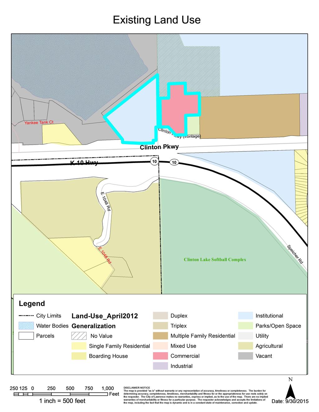
2 Z Item No. 6A- 2 SUP ; Special Use Permit for Active Recreation Use, Indoor for KU Tennis Facility, Major Modifications concurrent submittal with rezoning application. PLANS AND STUDIES REQURIED Traffic Study Not required for rezoning, refer to related SUP application Downstream Sanitary Sewer Analysis Not required for rezoning, refer to related SUP application. Drainage Study Not required for rezoning, refer to related SUP application Retail Market Study Not applicable to residential request. ATTACHMENTS 1. Area Map 2. Surrounding land use map PUBLIC COMMENT RECEIVED PRIOR TO PRINTING 1. Wakarusa Watershed Joint District No. 35. Stating opposition to development below the dam. Project Summary: This proposed request is for the rezoning of property to establish a single zoning district and amend the district boundary to incorporate all of the property associated with the use located at 5200 and 5300 Clinton Parkway. This application is submitted concurrently with SUP that includes the expansion of the use for Active Recreation. Yankee Tank View Addition 2 nd Plat GPI RS40 Sport 2 sport RM12 Figure 1: Subject Property and Existing Zoning Map
3 Z Item No. 6A- 3 History: In 1995 a Conditional Use Permit [CUP ] was approved for ball fields located in the unincorporated county, to the west of the First Serve Tennis property. These fields have since been platted as Sport-2-Sport Addition, Lot 1 and have been annexed into the City. In 1995 a Use Permitted upon Review [UPR ] was approved for an indoor athletic complex on Lot 2, The Landing. After the annexation of the ball fields, a UPR was approved for parking and batting cages on the ball fields site and a building addition to Sport-2-Sport building. Lot 2 of The Landing was split into Lot 2A and Lot 2B in February, 1999 [LS ]. A UPR [UPR ] was approved for the construction of a gymnastics and dance studio on the southern portion of Lot 2A, The Landing in February, In 2006, First Serve Tennis occupied the former Sport-2-Sport building on Lot 2B, The Landing and purchased the northern portion of Lot 2A as well as land from the adjoining parkland to the north. In May 2006, UPR was approved to provide tennis practice facilities for the local university and high-school teams by expanding the building to provide additional indoor courts and constructing 4 outdoor courts. 1. CONFORMANCE WITH THE COMPREHENSIVE PLAN Applicant s Response: The request conforms with Horizon 2020 by making a current inappropriate zoning conform with the existing zoning of the facility. Key features of the Comprehensive Plan include support for infill development and redevelopment which provides a range of residential, commercial, office, industrial and public uses within these parcels, consistent and compatible with the established land use pattern in surrounding areas. The existing land use map identifies the area along the north side of Clinton Parkway west of Wakarusa Drive as suitable for Medium Density/High Density Residential Development. This land use designation is consistent with the predominant RM12 (Multi-Dwelling Residential) District Zoning in the area. RM12 is a medium density residential district. This district allows other nonresidential uses including Community Facilities, some Recreational Facilities, and Religious Assembly uses. Medium-density residential zoning is recommended along major roadways. The proposed request is intended to align the district boundary with the parcel boundaries in the immediate area. The property currently includes two separate parcels with three different zoning districts. Chapter 5, Horizon 2020, addresses residential land use. The subject property is an existing nonresidential (Active Recreation) use. Policies addressing infill development compatibility density and housing types are not applicable to this request. However, other policies that address neighborhood concepts, patterns, and transitions are applicable. The property, located on the north side of Clinton Parkway, represents the southern edge of the West Lawrence Neighborhood. Medium density residential land uses including transitional land uses, are appropriate along neighborhood edges. Medium and Higher Density Residential Land Use Policy 1.1 states Development proposals shall be reviewed for compatibility with existing land use. The review should include use, building type, density and intensity of use, architectural style, scale, access sand its relationship to the neighborhood and the amount and treatment of screening and open space. This application include a portion of the property used for the Active Recreation Facility that is currently zoned GPI to the north and the parking lot area, located to the west that is zoned RS40. The application aligns the zoning district boundary with the property boundary establishing a uniform district within the surrounding area.
4 Z Item No. 6A- 4 Staff Finding The proposed request is consistent with the land use recommendations in Horizon ZONING AND USE OF NEARBY PROPERTY, INCLUDING OVERLAY ZONING Current Zoning and Land Use: 5200 Clinton Parkway RM12 (Multi-Dwelling Residential) District and GPI (General Public and Institution) District. Existing building housing Active Recreation use and outdoor tennis courts. Surrounding Zoning and Land Use: To the North To the East To the South To the West 5300 Clinton Parkway RS40 (Single Dwelling Residential) District. Existing parking lot and former softball fields (fields have been removed) County A (Agricultural) District; Existing Lake Alvamar (Yankee Tank Lake) and drainage ways. GPI (General Public and Institution) District; Existing City property containing multiple primary uses including future park to the immediate north of subject property. RM12 (Multi-Dwelling Residential) District along the north side of Clinton Parkway; Existing uses include 5150 Clinton Parkway Sports and Recreation, Participant (Indoor) and Multi-Dwelling Residential development. OS (Open Space) located east of Olympic Drive (extended south of Clinton Parkway); Existing K-10 Highway and Clinton Lake Softball Complex [Sports and Recreation, Participant, Outdoor)]. County A (Agricultural) District located west of Olympic Drive (extended south of Clinton Parkway); Existing residential uses. UR (Urban Reserve); existing vacant land and includes portion of dam. Staff Finding The area surrounding the subject properties contained in this request includes a mix of residential and non-residential zoning districts and both residential and non-residential uses. The majority of the surrounding area is associated with Lake Alvamar (Yankee Tank Lake) to the northwest and City property to the northeast on the north side of Clinton Parkway. The area on the south side of Clinton Parkway includes property owned by the Corps of Engineers (Clinton Lake Softball complex), K-10 highway right-of-way, and a rural residential neighborhood. 3. CHARACTER OF THE NEIGHBORHOOD Applicant s Response: The current structure occupies a majority of the neighborhood. There is a City park to the north, Lake Alvamar to the west, Clinton Parkway/bypass to the south and multifamily to the east.
5 Z Item No. 6A- 5 The properties included in this application are located within the boundary of the West Lawrence Neighborhood. The neighborhood boundary does not extend south of Clinton Parkway. The area along Clinton Parkway between Wakarusa Drive and K-10 Highway includes commercial, office and industrial uses at the intersection of Wakarusa Drive and Clinton Parkway. The area includes developed and undeveloped residential uses west of the subject property to K-10 Highway. Both Lake Alvamar, located in the West of K-10 Plan boundary and the City s Property to the north represent large tracts of land with open space uses associated with them. The west side of the City property is designated as a future park. The area along Wakarusa Drive is occupied by various public facility uses. Another significant feature of the surrounding neighborhood is the floodplain boundary within the immediate area of the lake. The existing parking lot, 5300 Clinton Parkway, is completely encumbered by the regulatory floodplain that also covers the lake. The residential uses in the areas to the east and west of the subject property are located north and south of Clinton Parkway and are generally accessible from an interior street or drive access point. The subject property shares an access with the multi-dwelling use to the east from the Clinton Parkway Frontage Road. Staff Finding Clinton Parkway is the south boundary of the West Lawrence Neighborhood. A mix of uses are located along the perimeter of the neighborhood. 4. PLANS FOR THE AREA OR NEIGHBORHOOD, AS REFLECTED IN ADOPTED AREA AND/OR SECTOR PLANS INCLUDING THE PROPERTY OR ADJOINING PROPERTY Staff Finding There are no adopted neighborhood, area or sector plans that include the subject property. 5. SUITABILITY OF SUBJECT PROPERTY FOR THE USES TO WHICH IT HAS BEEN RESTRICTED UNDER THE EXISTING ZONING REGULATIONS Applicant s Response: The application is correcting the zoning that is technically not allowed. We are coordinating the properties to allow for shared parking, and removal of RS40 (which is not an appropriate zoning for this property). Property included in this request includes approximately 1.14 acres zoned GPI and 9.7 acres zoned RS40 zoning districts. The existing RM12 property containing approximately 4.5 acres is also included so that one new ordinances can be adopted that will contain all of the parcels under common ownership. If approved, the request will revise the district boundary to follow consistent property lines and result in a uniform district for the subject property. Development restrictions relate to the location and proximity of the Lake Alvamar Dam and spillway. The area west of Olympic Drive is unsuitable for development regardless of the base zoning district. The existing improvements were permitted through various Conditional Use Permit and Use Permitted upon Review applications per the 1966 Douglas County Zoning Code and the Lawrence Zoning Code. As the property was annexed and a new code was adopted in 2006, the structure of permitted uses in various districts has been altered. Some recreation uses are allowed in the residential districts. Active Recreation uses are allowed in the RM12 District subject to a Special Use Permit. Uses that have a strong commercial component or orientation are more likely to be
6 Z Item No. 6A- 6 considered Participant Sports or Entertainment & Spectator Sports which would not be allowed in an RM12 district. Section of the Land Development Code lists the allowed Public and Civic Uses allowed uses in the residential zoning districts including the RM12 District. For the purposes of this discussion only the recreational uses are listed in this report. Key: A = Accessory P = Permitted S = Special Use * = Standard Applies - = Use not allowed RS40 RS20 RS10 RS7 RS5 Base Zoning Districts RS3 RSO RM12 RM12D RM15 RM24 RM32 RMG RMO Use-Specific Standards (Sec. 20-) PUBLIC AND CIVIC USE GROUP Recreational Facilities Active Recreation S S S S S S S S S S S S S Entertainment & Spectator Sports, General Entertainment & Spectator Sports, Limited Passive Recreation P P P P P P P P P P P P P P Nature Preserve/Undeveloped P P P P P P P P P P P P P Private Recreation P P P P P P P P P P P P P Participant Sports & Recreation, Indoor Participant Sports & Recreation, Outdoor Staff Finding Approval of the request establishes a uniform district boundary along Clinton Parkway that is also consistent with platted lot lines. Development suitability is impacted by additional factors other than the base zoning district. 6. LENGTH OF TIME SUBJECT PROPERTY HAS REMAINED VACANT AS ZONED Applicant s Response: The property is not vacant to Current: GPI and RS40 zoning districts. GPI zoned property part of existing Active Recreation use. RS40 property is developed as existing parking lot and open space to 2006: Prior to 2006, the property to the north was zoned RS-1 (Single-Family Residence) District and RS-A (Single-Family Residence Agricultural) District. The RS-1 district was typically associated with designating City or Public properties. The RS-A district was designed and established for very low density residential development with a minimum lot area of 1 acre. The RS-A District was rezoned when the property was annexed in The property was originally developed as an extension of the Sport-2-Sport complex and included two adult softball fields. Since the property at the time was outside of the City Limits the property was permitted through approval of a Conditional Use Permit (CUP ). This CUP was considered concurrently with a Use Permitted upon Review (UPR ) for the Sport-2-Sport facility that was located in the City
7 Z Item No. 6A- 7 Limits and zoned RM-1 in Prior to annexation the softball field had been zoned A-1 since The GPI portion of the application was previously owned by the City of Lawrence and included as part of a future park located on the west portion of a 160 acre site adjacent to Wakarusa Drive. The property was transferred to First Serve Tennis to accommodate a building addition for a community tennis facility in The expansion was completed but the property was not rezoned. Staff Finding Recreation Uses have been developed at this site since the late 1990 s. The property is not vacant but is developed with an existing building, outdoor tennis courts, and a surface parking lot. 7. EXTENT TO WHICH APPROVING THE REZONING WILL DETRIMENTALLY AFFECT NEARBY PROPERTIES Applicant s Response: There will be no detrimental affects to any adjacent properties. The proposed request is intended to align the district boundary with the property boundaries in the area and remove split zoning from property. This change provides efficiency in administration of the City Code and provides clarity for the property owner. Staff has been contacted by the Wakarusa Watershed Joint District #35 regarding development plans for the western portion of the property (5300 Clinton Parkway) that is currently zoned RS40. Future development of this property is not recommended. The area located below the dam is the emergency spillway for the lake and not suitable for physical improvements. Staff Finding There are no detrimental affects anticipated for nearby properties that would result from the rezoning of the property. 8. THE GAIN, IF ANY, TO THE PUBLIC HEALTH, SAFETY AND WELFARE DUE TO THE DENIAL OF THE APPLICATION, AS COMPARED TO THE HARDSHIP IMPOSED UPON THE LANDOWNER, IF ANY, AS A RESULT OF DENIAL OF THE APPLICATION Applicant s Response: This application corrects what should have been done years ago; therefore it provides better clarity to the general public. Evaluation of this criterion includes weighing the benefits to the public versus the benefit of the owners of the subject property. Benefits are measured based on anticipated impacts of the rezoning request on the public health, safety, and welfare. The proposed change in zoning for this project/application relates to the administrative processes rather than any specific development potential. The portion of the request that is currently zoned RS40 includes an existing surface parking lot. Softball fields that had been located on the property were removed to accommodate the reconstruction of the dam and provide an overflow spillway for the lake. No development in this area should be considered in the future. Additional restrictions, such as establishing a drainage easement may be necessary to articulate the intent and limitation of development on that part of the property included in this application. The portion of the property that is currently zoned GPI is located on property that is not a General Public and Institutional use. Rezoning the GPI portion of the request results in a district boundary
8 Z Item No. 6A- 8 that aligns with the platted lot line and parcel boundary. This provides efficiency for staff in administration of the Development Code and clarity to the property owner regarding allowed uses as well as density and dimensional standards applicable to development. Staff Finding Public gains that result from this application are nominal. The benefits to the public and to the applicant are ease and consistency in administration of the zoning code by providing a uniform zoning district. 9. PROFESSIONAL STAFF RECOMMENDATION Key considerations included in the review of this application are the existing improvements and the intended use of the property. The GPI zoning is a remnant from a building addition that required the then property owner to acquire land from the City to accommodate the building improvements in The existing parking lot is a remaining accessory improvement to the adult softball fields that were added in 1996 and later removed to accommodate the dam reconstruction. The parking lot now provides support for the existing recreation uses located at 5200 Clinton Parkway. Rezoning the property for consistency does not provide any impact to the surrounding area. Future development of that property would however create a hazard since the area is also the designated spillway for the lake. CONCLUSION Staff recommends approval of the proposed request. Staff has not identified any restrictions or conditions for the rezoning.
9
10 1718 A 5400 GPI 2001 A RS UR RS RM Clinton Pkwy (frontage) 5000 K-10 Hwy OP 10 UV 10 A-1 E 1048 Rd A OS Speicher Rd 4911 Clinton Lake Softball Complex Z : Rezone acres from GPI District and RS40 District to RM12 District SUP : Special Use Permit for an Active Recreation Use, an Indoor/Outdoor KU Tennis Facility Located at 5200 & 5300 Clinton Parkway µ Lawrence-Douglas County Planning Office Subject Property November 2015
PLANNING COMMISSION REPORT Regular Agenda Public Hearing Item
 PC Staff Report 11/12/12 Item No. 2B- 1 PLANNING COMMISSION REPORT Regular Agenda Public Hearing Item ITEM NO. 2B: A TO GPI; 110 ACRES; E OF K-10 & N OF W 6 TH ST (MKM) : Consider a request to rezone approximately
PC Staff Report 11/18/2013 Z Item No. 1-1
 Z-13-00401 Item No. 1-1 PLANNING COMMISSION REPORT Regular Agenda - Public Hearing Item PC Staff Report 11/18/2013 ITEM NO. 1: Z-13-00401 IG (General Industrial) District TO CS (Strip Commercial) District;
PLANNING COMMISSION REPORT Regular Agenda - Public Hearing Item
 Z-14-00056 Item No. 1-1 PLANNING COMMISSION REPORT Regular Agenda - Public Hearing Item PC Staff Report 4/21/2014 ITEM NO. 1: RSO TO CN1;.126 ACRES; 512 & 514 LOCUST ST (DRG) Z-14-00056: Consider a request
PLANNING COMMISSION REPORT Regular Agenda Public Hearing Item CONDITIONAL USE PERMIT FOR VERIZON WIRELESS; 1287 E 1200 RD (SLD)
") PC Staff Report 9/26/2016 CUP-16-00312 Item No. 5-1 PC Staff Report 9/26/2016 ITEM NO. 5 PLANNING COMMISSION REPORT Regular Agenda Public Hearing Item CONDITIONAL USE PERMIT FOR VERIZON WIRELESS; 1287
PC Staff Report 9/26/2016 CUP-16-00312 Item No. 5-1 PC Staff Report 9/26/2016 ITEM NO. 5 PLANNING COMMISSION REPORT Regular Agenda Public Hearing Item CONDITIONAL USE PERMIT FOR VERIZON WIRELESS; 1287
PLANNING COMMISSION REPORT Regular Agenda - Public Hearing Item
 Z-11-25-09; Z-11-26-09; Z-11-28-09 Item No. 2-1 PC Staff Report 3/28/11 PLANNING COMMISSION REPORT Regular Agenda - Public Hearing Item ITEM NO. 2A RM32 TO MU;.19 ACRES; 1340 TENNESSEE ST (MJL) Z-1-1-11:
PLANNING COMMISSION REPORT Regular Agenda Public Hearing Item
 PC Staff Report 06/22/2015 Item No. 3A - 1 PC Staff Report 6/22/2015 ITEM NO. 3A: PLANNING COMMISSION REPORT Regular Agenda Public Hearing Item RSO TO CN2; 10 ACRES; 4300 W 24 th Place (SLD) : Consider
PLANNING COMMISSION REPORT Regular Agenda Public Hearing Item PRD TO RM15; ACRES; 2101 EXCHANGE CT (KES)
") PC Staff Report 7/22/15 Z-14-00515 Item No. 3-1 PLANNING COMMISSION REPORT Regular Agenda Public Hearing Item PC Staff Report 7/22/15 ITEM NO. 3 PRD TO RM15; 9.818 ACRES; 2101 EXCHANGE CT (KES) Z-14-00515:
PC Staff Report 7/22/15 Z-14-00515 Item No. 3-1 PLANNING COMMISSION REPORT Regular Agenda Public Hearing Item PC Staff Report 7/22/15 ITEM NO. 3 PRD TO RM15; 9.818 ACRES; 2101 EXCHANGE CT (KES) Z-14-00515:
PLANNING COMMISSION REPORT Regular Agenda Public Hearing Item
 PC Staff Report 6/20/16 Item No. 4-1 PLANNING COMMISSION REPORT Regular Agenda Public Hearing Item PC Staff Report 06/20/16 ITEM NO. 4: IG to CS 1.56 ACRES; 706 E 23 RD STREET (MKM) : Consider a request
PLANNING COMMISSION REPORT Regular Agenda -Public Hearing Item
 PDP-13-00518 Item No. 3B- 1 PLANNING COMMISSION REPORT Regular Agenda -Public Hearing Item PC Staff Report 2/24/14 ITEM NO. 3B PRELIMINARY DEVELOPMENT PLAN FOR HERE @ KANSAS; 1101 INDIANA ST (SLD) PDP-13-00518:
PLANNING COMMISSION REPORT Regular Agenda Public Hearing Item
 PC Staff Report 10/21/2013 Item No. 3B - 1 PC Staff Report 10/21/2013 ITEM NO. 3B: PLANNING COMMISSION REPORT Regular Agenda Public Hearing Item A TO CR- FP; 8.4 ACRES; 1900 W. 31 st STREET (SLD) : Consider
PLANNING COMMISSION REPORT REGULAR AGENDA
 PP-4-4-11 Item No. 9-1 PLANNING COMMISSION REPORT REGULAR AGENDA PC Staff Report 06/22/11 ITEM NO 9: PRELIMINARY PLAT; KASOLD WATER TOWER ADDITION; SE OF TAM O SHANTER & KASOLD DR (MKM) PP-4-4-11: Consider
PLANNING COMMISSION REPORT Regular Agenda Public Hearing Item
 PC Staff Report 2/22/16 Z-15-00640 Item No. 1-1 PLANNING COMMISSION REPORT Regular Agenda Public Hearing Item PC Staff Report 2/22/16 ITEM NO. 1 Villa 26 Apartments Rezoning from (Commercial Strip) to
PLANNING COMMISSION REPORT Regular Agenda Public Hearing Item
 CUP-15-00474 Item No. 5-1 PC Staff Report 11/16/15 ITEM NO. 5 PLANNING COMMISSION REPORT Regular Agenda Public Hearing Item CONDITIONAL USE PERMIT FOR PUBLIC WHOLESALE WATER SUPPLY DISTRICT NO. 25; E 1300
Memorandum City of Lawrence Planning Department
 Memorandum City of Lawrence Planning Department TO: FROM: CC: Lawrence Douglas County Planning Commission Sandra Day, AICP, Planning Staff Applicant Date: January 14, 2013 RE: Item No. 3: Langston Heights
Planning Department Oconee County, Georgia
 Planning Department Oconee County, Georgia STAFF REPORT REZONE CASE #: 6985 DATE: October 31, 2016 STAFF REPORT BY: Andrew C. Stern, Planner APPLICANT NAME: Williams & Associates, Land Planners PC PROPERTY
PLANNING COMMISSION REPORT Regular Agenda Public Hearing Item. IG TO IL;.972 ACRES; 1021 E 31st (KES)
") PC Staff Report 11/16/15 Z-15-00471 Item No. 7-1 PLANNING COMMISSION REPORT Regular Agenda Public Hearing Item PC Staff Report 11/16/15 ITEM NO. 7 IG TO IL;.972 ACRES; 1021 E 31st (KES) Z-15-00471: Consider
PC Staff Report 11/16/15 Z-15-00471 Item No. 7-1 PLANNING COMMISSION REPORT Regular Agenda Public Hearing Item PC Staff Report 11/16/15 ITEM NO. 7 IG TO IL;.972 ACRES; 1021 E 31st (KES) Z-15-00471: Consider
PLANNING COMMISSION REPORT Regular Agenda - Public Hearing Item
 Z-12-29, 30, 32, 33, 34, 35, 36-11 to Item No. 5A 5G- 1 PLANNING COMMISSION REPORT Regular Agenda - Public Hearing Item PC Staff Report 02/27/2012 ITEM NO. 5A-5G Z-12-29, 30, 32, 33, 34, 35, 36-11 from
Allow continued use of existing grass runway for personal use by landowner.
 CUP-13-00193 Item No. 4-1 PLANNING COMMISSION REPORT Regular Agenda PC Staff Report 7/22/13 ITEM NO. 4: CONDITIONAL USE PERMIT; PRIVATE LANDING STRIP; 2215 N 500 (MKM) CUP-13-00193: Consider a Conditional
Subdivision of existing two lots into three lots.
 PP-15-00189 Item No. 4-1 PC Staff Report 06/22/2015 PLANNING COMMISSION REPORT NON PUBLIC HEARING ITEM PUBLIC HEARING ON THE VARIANCE ONLY ITEM NO 4: PRELIMINARY PLAT FOR DEERFIELD WOODS SUBDIVISION NO.
PLANNING COMMISSION REPORT Regular Agenda Public Hearing Item
 PC Staff Report 06/21/10 Item No. 4-1 PLANNING COMMISSION REPORT Regular Agenda Public Hearing Item ITEM NO. 4: PD-[TANGER PCD-1] TO CS; 1025 N. 3 rd STREET (SLD) : Consider a request to rezone approximately
PLANNING COMMISSION REPORT Regular Agenda Non Public Hearing Item
 PC Staff Report 3/23/15 FDP-14-00551 Item No. 2-1 PLANNING COMMISSION REPORT Regular Agenda Non Public Hearing Item PC Staff Report 3/23/15 ITEM NO. 2: FINAL DEVELOPMENT PLAN FOR HUTTON FARMS WEST PHASE
Planning Department Oconee County, Georgia STAFF REPORT
 Planning Department Oconee County, Georgia STAFF REPORT REZONE CASE #: 7332 DATE: November 28, 2017 STAFF REPORT BY: Gabriel Quintas, Planner APPLICANT NAME: Smith Planning Group PROPERTY OWNER: John Hadden
PLANNING COMMISSION REPORT Regular Agenda Public Hearing Item. PC Staff Report 12/14/15 A (County) TO RS10; 3 ACRES; 1041 N 1700 Road (KES)
 TO RS10; 3 ACRES; 1041 N 1700 Road (KES)") PC Staff Report 12/14/15 Z-15-00524 Item No. 3-1 PLNNING COMMISSION REPORT Regular genda Public Hearing Item PC Staff Report 12/14/15 ITEM NO. 3 (County) TO RS10; 3 CRES; 1041 N 1700 Road (KES) Z-15-00524:
PC Staff Report 12/14/15 Z-15-00524 Item No. 3-1 PLNNING COMMISSION REPORT Regular genda Public Hearing Item PC Staff Report 12/14/15 ITEM NO. 3 (County) TO RS10; 3 CRES; 1041 N 1700 Road (KES) Z-15-00524:
Midwest City, Oklahoma Zoning Ordinance
 2010 Midwest City, Oklahoma Zoning Ordinance 9/2/2010 Table of Contents Section 1. General Provisions... 5 1.1. Citation... 5 1.2. Authority... 5 1.3. Purpose... 5 1.4. Nature and Application... 5 1.5.
PLANNING COMMISSION REPORT REGULAR AGENDA. PC Staff Report 08/25/10 ITEM NO 6: PRELIMINARY PLAT; HALLMARK ADDITION; ACRES; 151 MCDONALD DR (MKM)
") PP-6-6-10 Item No. 6-1 PLANNING COMMISSION REPORT REGULAR AGENDA PC Staff Report 08/25/10 ITEM NO 6: PRELIMINARY PLAT; HALLMARK ADDITION; 5.252 ACRES; 151 MCDONALD DR (MKM) PP-6-6-10: Consider a Preliminary
PP-6-6-10 Item No. 6-1 PLANNING COMMISSION REPORT REGULAR AGENDA PC Staff Report 08/25/10 ITEM NO 6: PRELIMINARY PLAT; HALLMARK ADDITION; 5.252 ACRES; 151 MCDONALD DR (MKM) PP-6-6-10: Consider a Preliminary
Appendix A: Guide to Zoning Categories Prince George's County, Maryland
 Appendix A: Guide to Zoning Categories Prince George's County, Maryland RESIDENTIAL ZONES 1 Updated November 2010 R-O-S: Reserved Open Space - Provides for permanent maintenance of certain areas of land
Letter of Intent May 2017 (Revised November 2017)
") THE BEACH AT WOODMOOR LETTER OF INTENT MAY 2017 (REVISED NOVEMBER 2017) OWNER/APPLICANT: CONSULTANT: Lake Woodmoor Holdings LLC N.E.S. Inc. 1755 Telstar Drive, Suite 211 619 North Cascade Avenue Colorado
THE BEACH AT WOODMOOR LETTER OF INTENT MAY 2017 (REVISED NOVEMBER 2017) OWNER/APPLICANT: CONSULTANT: Lake Woodmoor Holdings LLC N.E.S. Inc. 1755 Telstar Drive, Suite 211 619 North Cascade Avenue Colorado
Urban Planning and Land Use
 Urban Planning and Land Use 701 North 7 th Street, Room 423 Phone: (913) 573-5750 Kansas City, Kansas 66101 Fax: (913) 573-5796 Email: planninginfo@wycokck.org www.wycokck.org/planning To: From: City Planning
PLANNING COMMISSION REPORT REGULAR AGENDA --NON-PUBLIC HEARING ITEM:
 PP-6-00068 Item No. 5B - PLNNING COMMISSION REPORT REGULR GEND --NON-PUBLIC HERING ITEM: PC Staff Report 04/25/6 ITEM NO. 5B: PRELIMINRY PLT FOR KING S RECYCLE CENTER; N 300 RD & E 750 RD (MKM) PP-6-00068:
4.2 RESIDENTIAL ZONING DISTRICTS
 4.2 RESIDENTIAL ZONING DISTRICTS A. Purpose: To define regulations and standards for each residential zoning district in the City. The following sections identify uses, regulations, and performance standards
Staff Planner Carolyn A.K. Smith
 Applicant Property Owner, Pamela K. & Steven A. Gray Public Hearing April 13, 2016 City Council Election District Princess Anne Agenda Item 8 Request Modification of Proffers (Modification to the proffer
Prince Edward County Zoning Ordinance. Effective October 1, 2007
 Prince Edward County Zoning Ordinance Effective October 1, 2007 ARTICLE I GENERAL PROVISIONS...6 SEC. 1-100 TITLE AND AUTHORITY...6 SEC. 1-102 JURISDICTION...6 SEC. 1-104 PURPOSE...6 SEC. 1-106 EFFECTIVE
PLANNING & DEVELOPMENT
 PLANNING & DEVELOPMENT STAFF REPORT Rezoning PETITION: APPLICANT: PROPERTY OWNER: TYPE OF REQUEST: SIZE OF TRACT: LOCATION: (#17-22) Rezone from A-PUD (Agri-Business Planned Unit Development) to A-PUD
City of Brooklyn Park Planning Commission Staff Report
 City of Brooklyn Park Planning Commission Staff Report Agenda Item: 6D Meeting Date: August 9, 2017 Originating Agenda Section: Public Hearing Department: Community Development Resolution: X Ordinance:
Town of Waxhaw Board of Commissioners. Waxhaw Police Department Community Meeting Room Tuesday January 12, 2016
 Town of Waxhaw Board of Commissioners Waxhaw Police Department Community Meeting Room Tuesday January 12, 2016 Petition RZ-003994-2015 A request by the Town of Waxhaw Planning & Community Development Department,
A Affordable Storage CUP Amendment, in Section 20, T35N R2W NMPM, at 4340B US Hwy 160W and 122 Meadows Dr.
 Archuleta County Development Services Planning Department 1122 HWY 84 P. O. Box 1507 Pagosa Springs, Colorado 81147 970-264-1390 Fax 970-264-3338 MEMORANDUM TO: Archuleta County Planning Commission FROM:
INDIAN RIVER COUNTY, FLORIDA. The Honorable Members of the Planning and Zoning Commission DEPARTMENT HEAD CONCURRENCE
 Public Hearing Legislative INDIAN RIVER COUNTY, FLORIDA M E M O R A N D U M TO: The Honorable Members of the Planning and Zoning Commission DEPARTMENT HEAD CONCURRENCE Robert M. Keating, AICP; Community
KNOXVILLE/KNOX COUNTY METROPOLITAN PLANNING COMMISSION SUBDIVISION REPORT - CONCEPT/USE ON REVIEW
 KNOXVILLE/KNOX COUNTY METROPOLITAN PLANNING COMMISSION SUBDIVISION REPORT - CONCEPT/USE ON REVIEW FILE #: 9-SC-17-C 9-I-17-UR AGENDA ITEM #: 17 AGENDA DATE: 9/14/2017 SUBDIVISION: APPLICANT/DEVELOPER:
DEVELOPMENT DEPARTMENT STAFF REPORT STAFF REPORT DRESDEN DRIVE TOWNHOMES DCI
 DEVELOPMENT DEPARTMENT STAFF REPORT Meeting Date: September 13, 2018 Item #: PZ2018-319 STAFF REPORT DRESDEN DRIVE TOWNHOMES DCI Request: Project Name: Development of Community Compact (DCI) and six concurrent
ZONING AMENDMENT & SUBDIVISION STAFF REPORT Date: March 1, 2018
 #13 SUB-000406-2018 & ZON-000407-2018 ZONING AMENDMENT & SUBDIVISION STAFF REPORT Date: March 1, 2018 NAME SUBDIVISION NAME LOCATION Creekside @ Kooiman Dairy Creekside @ Kooiman Dairy Subdivision (South
ARTICLE B ZONING DISTRICTS
 ARTICLE B ZONING DISTRICTS Sec. 8-3021 Established. In order to protect the character of existing neighborhoods; to prevent excessive density of population in areas which are not adequately served with
PLANNING COMMISSION REPORT PUBLIC HEARING ITEM. DE-ANNEXATION OF 2.4 ACRES LOCATED AT 1820 N. 3 rd STREET. (DDW)
") A-6-1-10 Item No. 5-1 PC Staff Report 9/20/10 PLANNING COMMISSION REPORT PUBLIC HEARING ITEM ITEM NO. 5: DE-ANNEXATION OF 2.4 ACRES LOCATED AT 1820 N. 3 rd STREET. (DDW) A-6-1-10: De-annexation of approximately
A-6-1-10 Item No. 5-1 PC Staff Report 9/20/10 PLANNING COMMISSION REPORT PUBLIC HEARING ITEM ITEM NO. 5: DE-ANNEXATION OF 2.4 ACRES LOCATED AT 1820 N. 3 rd STREET. (DDW) A-6-1-10: De-annexation of approximately
RESIDENTIAL DISTRICTS
 RESIDENTIAL DISTRICTS RESIDENTIAL DISTRICTS The residential district standards have been revised to reflect on-the-ground development conditions, while continuing to respect the use patterns established
ORDINANCE NO
 ORDINANCE NO. 2016 - AN ORDINANCE OF THE BOARD OF COUNTY COMMISSIONERS OF GLADES COUNTY, FLORIDA, AMENDING THE OFFICIAL ZONING MAP OF GLADES COUNTY FROM RESIDENTIAL SINGLE-FAMILY (RS) AND AGRICULTURAL
RM18 RS9 RM12 RS9 !( S DOCKET #: W3120 PROPOSED ZONING: GB-L EXISTING ZONING: HB-S. PETITIONER: Bank of North Carolina for property owned by Same
 DELANE DR DOCKET #: W3120 RM18 BARRY ST PROPOSED ZONING: GB-L RS9 EXISTING ZONING: HB-S IP OLD GREENSBORO RD WALES ST DENVER ST GEORGE BIG REDD CT LOUISE WILSON LN RM12!(DS MOSES LUCAS CT 585' 627' HB-S
PALM BEACH COUNTY PLANNING, ZONING AND BUILDING DEPARTMENT ZONING DIVISION
 PALM BEACH COUNTY PLANNING, ZONING AND BUILDING DEPARTMENT ZONING DIVISION Application No.: Z/CA-2013-00493 Application Name: Trails Charter School Control No.: 2013-00085 Applicant: MG3 ALF Military LLC
STAFF SUMMARY OF S18-04 SPECIAL USE PERMIT APPLICATION
 APPLICATION SUMMARY Case Number: S18-04 Request: STAFF SUMMARY OF S18-04 SPECIAL USE PERMIT APPLICATION Special use permit in order to develop an indoor/outdoor recreation facility Applicant: Property
RS9 LB-S RSQ-S RS9 RS9 DOCKET: W2822 PROPOSED ZONING: LB EXISTING ZONING: RS-9. PETITIONER: J&J Properties of W-S, LLC, for property owned by Same
 HAYMOUNT ST RS9 IP DOCKET: W2822 PROPOSED ZONING: LB POPE RD CLEMMONSVILLE RD EXISTING ZONING: RS-9 RSQ-S LB-S OLD SALISBURY RD WINSTON-SALEM ZONING FORSYTH COUNTY ZONING PETITIONER: J&J Properties of
STAFF REPORT VARIANCE FROM LDC CHAPTER 17, SECTION 15(d)(1)(a) CASE NO
(1)(a) CASE NO") STAFF REPORT VARIANCE FROM LDC CHAPTER 17, SECTION 15(d)(1)(a) CASE NO. 16-90000010 REQUEST: OWNER: APPLICANT: LOCATION: RECOMMENDATION: Variance from the Land Development Code (LDC) to allow a minimum
STAFF REPORT VARIANCE FROM LDC CHAPTER 17, SECTION 15(d)(1)(a) CASE NO. 16-90000010 REQUEST: OWNER: APPLICANT: LOCATION: RECOMMENDATION: Variance from the Land Development Code (LDC) to allow a minimum
Memorandum City of Lawrence Planning & Development Services
 Memorandum City of Lawrence Planning & Development Services TO: City Commission FROM: Planning Staff Date: July 11, 2017 RE: Industrial District Review Attachments: 1. Existing Industrial Zoning Map 2.
EDGERTON CITY HALL PLANNING COMMISSION MEETING REGULAR SESSION March 12, 2019
 EDGERTON CITY HALL PLANNING COMMISSION MEETING REGULAR SESSION The met in regular session with Chair John Daley calling the meeting to order at 7:00 p.m. All present participated in the Pledge of Allegiance.
Cover Letter with Narrative Statement
 Cover Letter with Narrative Statement March 31, 2017 rev July 27, 2017 RE: Rushton Pointe Residential Planned Unit Development Application for Public Hearing for RPUD Rezone PL2015 000 0306 Mr. Eric Johnson,
Planning Commission Hearing Date: 2/21/2017 Board of County Commissioners Hearing Date: 3/8/2017
 COMMISSIONERS: DARRYL GLENN (PRESIDENT) MARK WALLER (PRESIDENT PRO TEMPORE) STAN VANDERWERF LONGINOS GONZALEZ PEGGY LITTLETON PLANNING AND COMMUNITY DEVELOPMENT DEPARTMENT CRAIG DOSSEY, EXECUTIVE DIRECTOR
Marcel Williams, MPC Project Planner
 TO: FROM: The Planning Commission MPC Staff DATE: SUBJECT: Petition to Rezone Property Heath Shelton, Owner Jay Maupin, Agent 2026 Habersham Street Aldermanic District: 2, Bill Durrence County Commission
Conditional Use Permit case no. CU 14-06: Bristol Village Partners, LLC
 PLANNING AND ZONING COMMISSION STAFF REPORT August 7, 2014 Conditional Use Permit case no. CU 14-06: Bristol Village Partners, LLC CASE DESCRIPTION: LOCATION: LEGAL DESCRIPTION: EXISTING LAND USE: ZONING:
SECTION 6. RESIDENTIAL DISTRICTS
 SECTION 6. RESIDENTIAL DISTRICTS 6.1 RESIDENTIAL DISTRICTS PURPOSE 6.2 PERMITTED AND CONDITIONAL USES 6.3 LOT AND BUILDING BULK REGULATIONS 6.4 GENERAL STANDARDS OF APPLICABILITY 6.1 RESIDENTIAL DISTRICTS
Diamond Falls Subdivision PROPOSED YELLOWSTONE COUNTY BOARD OF PLANNING FINDINGS OF FACT
 Diamond Falls Subdivision PROPOSED YELLOWSTONE COUNTY BOARD OF PLANNING FINDINGS OF FACT The City/County Planning Staff has prepared the Findings of Fact for the Diamond Falls Subdivision. These findings
Urban Planning and Land Use
 Urban Planning and Land Use 701 North 7 th Street, Room 423 Phone: (913) 573-5750 Kansas City, Kansas 66101 Fax: (913) 573-5796 Email: planninginfo@wycokck.org www.wycokck.org/planning To: From: City Planning
TOWN OF ORO VALLEY PLANNING & ZONING COMMISSION MEETING DATE: December 6, 2011
 PLANNING & ZONING COMMISSION MEETING DATE: December 6, 2011 TO: FROM: SUBJECT: PLANNING & ZONING COMMISSION Matt Michels, Senior Planner mmichels@orovalleyaz.gov; tel. 229-4822 Public Hearing: Rancho de
AGENDA PLANNING COMMISSION Tuesday, April 18, :00 PM City Council Chambers 125 East Avenue B, Hutchinson, Kansas
 AGENDA PLANNING COMMISSION Tuesday, April 18, 2017 5:00 PM City Council Chambers 125 East Avenue B, Hutchinson, Kansas 1. ROLL CALL Macklin Woleslagel Bisbee (Chair) Hamilton Peirce Vacant Carr Hornbeck
PALM BEACH COUNTY PLANNING, ZONING AND BUILDING DEPARTMENT ZONING DIVISION ZONING COMMISSION VARIANCE STAFF REPORT 5/7/2009
 PALM BEACH COUNTY PLANNING, ZONING AND BUILDING DEPARTMENT ZONING DIVISION ZONING COMMISSION VARIANCE STAFF REPORT 5/7/2009 APPLICATION NO. CODE SECTION REQUIRED PROPOSED VARIANCE ZV-2009-00991 3.F.4.D.10.b.1).
PLANNING COMMISSION REPORT Regular Agenda Public Hearing Item CONDITIONAL USE PERMIT FOR WESTAR ENERGY; 1703 E 902 RD (MKM)
") CUP-14-000167 Item No. 4-1 PC Staff Report 6/23/14 ITEM NO. 4 PLANNING COMMISSION REPORT Regular Agenda Public Hearing Item CONDITIONAL USE PERMIT FOR WESTAR ENERGY; 1703 E 902 RD (MKM) CUP-14-00167: Consider
CUP-14-000167 Item No. 4-1 PC Staff Report 6/23/14 ITEM NO. 4 PLANNING COMMISSION REPORT Regular Agenda Public Hearing Item CONDITIONAL USE PERMIT FOR WESTAR ENERGY; 1703 E 902 RD (MKM) CUP-14-00167: Consider
ARTICLE VII. NONCONFORMITIES. Section 700. Purpose.
 ARTICLE VII. NONCONFORMITIES. Section 700. Purpose. The purpose of this chapter is to regulate and limit the development and continued existence of legal uses, structures, lots, and signs established either
TREASURE COAST REGIONAL PLANNING COUNCIL M E M O R A N D U M
 TREASURE COAST REGIONAL PLANNING COUNCIL M E M O R A N D U M To: Council Members AGENDA ITEM 6A From: Date: Subject: Staff May 20, 2011 Council Meeting Local Government Comprehensive Plan Review Draft
3. What is the requested zoning for the property (including intensity designator)? RM1-45 Residential (Multi-Dwelling).
? RM1-45 Residential (Multi-Dwelling).") B. SUBJECT PROPERTY INFORMATION General location of subject property and address (if address has been assigned): Northside- 819 Stoddard St. Missoula, MT 59802 Legal Description - complete and unabbreviated:
B. SUBJECT PROPERTY INFORMATION General location of subject property and address (if address has been assigned): Northside- 819 Stoddard St. Missoula, MT 59802 Legal Description - complete and unabbreviated:
City of Valdosta Land Development Regulations
 Chapter 206 Section 206-1 Base Zoning Districts Standards for Uses, Structures, and Property Development (B) (C) Principal Uses and Structures. Principal uses and structures permitted in each base zoning
1. Future Land Use FLU6.6.8 Land uses within the Rural Service Area portion of the Wekiva Study Area shall be limited to very low and low intensity
 1. Future Land Use FLU6.6.8 Land uses within the Rural Service Area portion of the Wekiva Study Area shall be limited to very low and low intensity uses to the greatest extent possible. Existing land uses
O-I (Office-Institutional) and AG-1(Agricultural)
 and AG-1(Agricultural)") PROPERTY INFORMATION ADDRESS 3503 and 3505 Bethany Bend DISTRICT, LAND LOTS 2/1 973 and 974 OVERLAY DISTRICT State Route 9 PETITION NUMBERS EXISTING ZONING O-I (Office-Institutional) and AG-1(Agricultural)
PROPERTY INFORMATION ADDRESS 3503 and 3505 Bethany Bend DISTRICT, LAND LOTS 2/1 973 and 974 OVERLAY DISTRICT State Route 9 PETITION NUMBERS EXISTING ZONING O-I (Office-Institutional) and AG-1(Agricultural)
Planning & Zoning Commission
 Zoning Change 13-03 (FM 646) Planning & Zoning Commission Planning & Development Department June 3, 2013 Request Permitted Uses Rezone approximately 24.89 acres of undeveloped land from RSF-7 (Residential
M E M O R A N D U M. Meeting Date: October 23, Item No. F-1. Planning and Zoning Commission. Daniel Turner, Planner I
 M E M O R A N D U M Meeting Date: October 23, 2017 Item No. F-1 To: From: Subject: Planning and Zoning Commission Daniel Turner, Planner I PUBLIC HEARING: Consider a recommendation of a of Planned Development
B. The Plan is in conformity with the Comprehensive Plan.
 ARTICLE 17 PLANNING UNIT DEVELOPMENT 17.01 INTENT The purpose of this Section is to permit the creation of new Planned Unit Developments, permitted as Conditional Uses where maximum variations of design
M E M O R A N D U M. Meeting Date: April 9, Item No. F-1. Planning and Zoning Commission. Scott Bradburn, Planner I
 M E M O R A N D U M Meeting Date: April 9, 2018 Item No. F-1 To: From: Subject: Planning and Zoning Commission Scott Bradburn, Planner I PUBLIC HEARING: Consider a recommendation for a Specific Use Permit
ARTICLE 2 ZONING DISTRICTS AND MAPS
 ARTICLE 2 ZONING DISTRICTS AND MAPS SECTION 2.100 PURPOSE OF DISTRICTS Section 2.101. For the purpose of this Ordinance, Billings Township is hereby divided into districts as follows: DISTRICT NAME SYMBOL
Request Subdivision Variance (Sections 4.4 (b) & (d) of the Subdivision Regulations) Staff Recommendation Approval. Staff Planner Jimmy McNamara
 & (d) of the Subdivision Regulations) Staff Recommendation Approval. Staff Planner Jimmy McNamara") Applicant & Property owner Titan Investment Group, Inc., a Virginia Corporation Public Hearing April 12, 2017 City Council Election District Kempsville Agenda Item 5 Request Subdivision Variance (Sections
Applicant & Property owner Titan Investment Group, Inc., a Virginia Corporation Public Hearing April 12, 2017 City Council Election District Kempsville Agenda Item 5 Request Subdivision Variance (Sections
ARTICLE 23 CONDOMINIUM STANDARDS
 ARTICLE 23 CONDOMINIUM STANDARDS Section 23.01 Intent. The intent of this Article is to provide regulatory standards for condominiums and site condominiums similar to those required for projects developed
TOOELE COUNTY LAND USE ORDINANCE CHAPTER 31 Page 1
 CHAPTER 31 PLANNED COMMUNITY ZONE (P-C) Section 31-1 Definitions. 31-2 Purpose. 31-3 Land use districts. 31-4 P-C zone area minimum requirements. 31-5 Permitted uses. 31-6 Conditional uses. 31-7 Planning
4.2 LAND USE INTRODUCTION
 4.2 LAND USE INTRODUCTION This section of the EIR addresses potential impacts from the Fresno County General Plan Update on land use in two general areas: land use compatibility and plan consistency. Under
1. Allow a workable, interrelated mix of diverse land uses;
 5-24 PUD Planned Unit Development 5-24.1 Purpose A. The Planned Unit Development (PUD) District is intended to encourage flexible and innovative design in the development of appropriate sites as integrated
Staff Report: Date: Applicant: Property Identification: Acreage of Request: Current Zoning of Requested Area: Requested Action: Attached:
 Staff Report: Completed by Jeff Palmer Director of Planning & Zoning Date: November 7, 2018, Updated November 20, 2018 Applicant: Greg Smith, Oberer Land Developer agent for Ronald Montgomery ET AL Property
Urban Planning and Land Use
 Urban Planning and Land Use 701 North 7 th Street, Room 423 Phone: (913) 573-5750 Kansas City, Kansas 66101 Fax: (913) 573-5796 Email: planninginfo@wycokck.org www.wycokck.org/planning To: From: City Planning
Co- Op Entertainment District
 Co- Op Entertainment District The purpose of the project is to provide a mixed-use, walkable development consisting primarily of retail, high density residential, entertainment, restaurant, civic and office
PALM BEACH COUNTY PLANNING, ZONING AND BUILDING DEPARTMENT ZONING DIVISION ZONING COMMISSION VARIANCE STAFF REPORT 06/05/2014
 PALM BEACH COUNTY PLANNING, ZONING AND BUILDING DEPARTMENT ZONING DIVISION ZONING COMMISSION VARIANCE STAFF REPORT 06/05/2014 APPLICATION NO. ZV-2013-03120 CODE SECTION REQUIRED PROPOSED VARIANCE (V1)
TOTTENHAM SECONDARY PLAN
 TOTTENHAM SECONDARY PLAN AMENDMENT NO. 11 TO THE OFFICIAL PLAN OF THE TOWN OF NEW TECUMSETH The following text and schedules to the Official Plan of the Town of New Tecumseth constitute Amendment No. 11
DEPARTMENT OF PLANNING JEFFERSON PARISH, LOUISIANA
 DEPARTMENT OF PLANNING JEFFERSON PARISH, LOUISIANA SUBDIVISION REPORT DOCKET NO: ES-89-15-PF SUMMARY NO: COUNCIL DISTRICT 2 Paul D. Johnston COUNCIL AT LARGE: A Chris Roberts B Elton M. Lagasse ADVERTISING
NEWTON COUNTY BOARD OF COMMISSIONERS REQUEST FOR REZONING
 NEWTON COUNTY BOARD OF COMMISSIONERS REQUEST FOR REZONING CASE NUMBER PROPOSED LAND USE MAP EXISTING LAND USE MAP PROPOSED ZONING EXISTING ZONING WATERSHED LOCATION OWNER PETITIONER REPRESENTATIVE N/A
DENTON Developer's Handbook
 DENTON Developer's Handbook A guide for land development in the City of Denton Department of Development Services 2017 2 Table of Contents 1. City of Denton Development Process...5 Role of the Development
(H) RM-10: LOW-DENSITY MULTIFAMILY RESIDENTIAL DISTRICT 123
 RM-10: LOW-DENSITY MULTIFAMILY RESIDENTIAL DISTRICT 123") Section 23-3-2(H): RM-10: Low-Density Multifamily Residential District (H) RM-10: LOW-DENSITY MULTIFAMILY RESIDENTIAL DISTRICT 123 The Low-Density, Multifamily Residential (RM-10) District is established
Section 23-3-2(H): RM-10: Low-Density Multifamily Residential District (H) RM-10: LOW-DENSITY MULTIFAMILY RESIDENTIAL DISTRICT 123 The Low-Density, Multifamily Residential (RM-10) District is established
Legal Description Part of the Western Half of the Eastern Half of the Northwest Quarter of Section 30, Le Ray Township
 Owner and Applicant s 20448 State Highway 83 Mankato, MN 56001 Request and Location Request for review and approval of a Conditional Use Permit to allow an Elder Care Residential Unit to be constructed
Request Subdivision Variance (Section 4.4 (b) of the Subdivision Regulations) Staff Planner Kevin Kemp
 of the Subdivision Regulations) Staff Planner Kevin Kemp") Applicant & Property Owner Public Hearing December 14, 2016 City Council Election District Rose Hall Agenda Item 16 Request Subdivision Variance (Section 4.4 (b) of the Subdivision Regulations) Staff Planner
Applicant & Property Owner Public Hearing December 14, 2016 City Council Election District Rose Hall Agenda Item 16 Request Subdivision Variance (Section 4.4 (b) of the Subdivision Regulations) Staff Planner
Request Conditional Use Permit (Bulk Storage Yard) Staff Recommendation Approval. Staff Planner Robert Davis
 Staff Recommendation Approval. Staff Planner Robert Davis") Applicant Property Owner Glaser, LLC Public Hearing March 14, 2018 City Council Election District Rose Hall Agenda Item 5 Request Conditional Use Permit (Bulk Storage Yard) Staff Recommendation Approval
Applicant Property Owner Glaser, LLC Public Hearing March 14, 2018 City Council Election District Rose Hall Agenda Item 5 Request Conditional Use Permit (Bulk Storage Yard) Staff Recommendation Approval
CITY OF LEBANON RUSSELL DRIVE AREA MIXED USE NEIGHBORHOOD CENTER FINAL IMPLEMENTATION PLAN
 CITY OF LEBANON RUSSELL DRIVE AREA MIXED USE NEIGHBORHOOD CENTER FINAL IMPLEMENTATION PLAN TGM Contract 2G-01 #22425 Deliverable 15.5 Prepared by: Satre Associates, P.C. Planners, Landscape Architects,
PLANNED UNIT DEVELOPMENT & SUBDIVISION STAFF REPORT Date: April 18, 2019
 PLANNED UNIT DEVELOPMENT & SUBDIVISION STAFF REPORT Date: April 18, 2019 DEVELOPMENT NAME SUBDIVISION NAME Springhill Village Subdivision Springhill Village Subdivision LOCATION 4350, 4354, 4356, 4358,
THE AREA PLAN COMMISSION OF ST. JOSEPH COUNTY, IN AGENDA
 THE AREA PLAN COMMISSION OF ST. JOSEPH COUNTY, IN AGENDA Tuesday, June 20, 2017 Fourth-Floor Council Chambers 3:30 p.m. County-City Building, South Bend, IN PUBLIC HEARINGS: 1. Rezonings: A. A combined
Attachment 4. Planning Commission Staff Report. June 26, 2017
 Planning Commission Staff Report June 26, 2017 Agenda #: Regular Agenda - 2 Title: Applicant: Request: Location: Existing Zoning: Proposed Use: Staff Planner: The Brands and The Brands West Eagle Crossing
Parkland-Spanaway-Midland LUAC - Agenda
 1. 6:30 P.M. Parkland-Spanaway-Midland LUAC - Agenda Documents: 8 2 17 PSMAC Agenda.pdf 2. Parkland-Spanaway-Midland LUAC Initial Project Review Documents: Lincoln Court PP IPR PSMAC-RJ.pdf Department
HB-S RM8-S RS9 RM18 HB-S RS9 DOCKET #: W2872. PROPOSED ZONING: RM8-S (Child Day Care Center) EXISTING ZONING: RS9 and RM8-S
 EXISTING ZONING: RS9 and RM8-S") 150' 80' RS9 UNIVERSITY PW STANLEYVILLE DR HB-S LB 123' 70' PROPOSED BELTWAY!( RM8-S S 289' NOEL DR 202' NITA AV MILL CREEK DOCKET #: W2872 PROPOSED ZONING: RM8-S (Child Day Care Center) EXISTING ZONING:
150' 80' RS9 UNIVERSITY PW STANLEYVILLE DR HB-S LB 123' 70' PROPOSED BELTWAY!( RM8-S S 289' NOEL DR 202' NITA AV MILL CREEK DOCKET #: W2872 PROPOSED ZONING: RM8-S (Child Day Care Center) EXISTING ZONING:
PLANNING COMMISSION STAFF REPORT
 PLANNING COMMISSION STAFF REPORT REZONING CASE: RZ-15-002 REPORT DATE: January 26, 2016 CASE NAME: Thursday Lunch Club Rezoning PLANNING COMMISSION DATE: February 17, 2016 ADDRESS OF REZONING PROPOSAL:
DIVISION 23. CUP COMMUNITY UNIT PLAN DISTRICT
 DIVISION 23. CUP COMMUNITY UNIT PLAN DISTRICT DIVISION 23. CUP COMMUNITY UNIT PLAN DISTRICT Sec. 64-894. Scope and intent. Sec. 64-895. Use regulations. Sec. 64-896. Development plan. Sec. 64-897. Development
Planning & Zoning Commission
 Planning & Zoning Commission Planning & Development Department August 14, 01 Zoning Map Amendment MAP-1-0001 (Bay View Section 4) Request Rezone approximately 1.19 acres from OS (Open Space) to RSF- (Residential
Annexation Procedure
 Annexation Procedure Meet with Planning Department Staff - Recommended Figure 1.9 Submit petition for Annexation, w/ majority of property owner s signature, legal description of proposed property, lot