Six Mile Market Place Mixed Use
|
|
|
- Bethanie Jackson
- 5 years ago
- Views:
Transcription
1 Planned Development MU-SR Guidelines Six Mile Market Place Mixed Use A PD featuring: Workforce Housing January 21, 2015 Applicant: Real Estate Capital Management Prepared By: Real Estate Capital Management, Inc ewall Street Mount Pleasant, SC
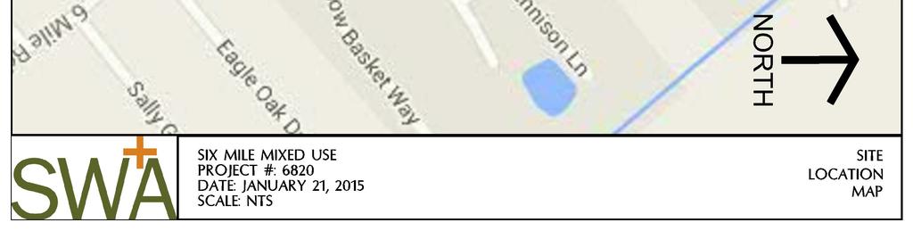
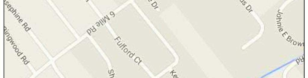
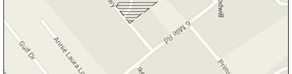
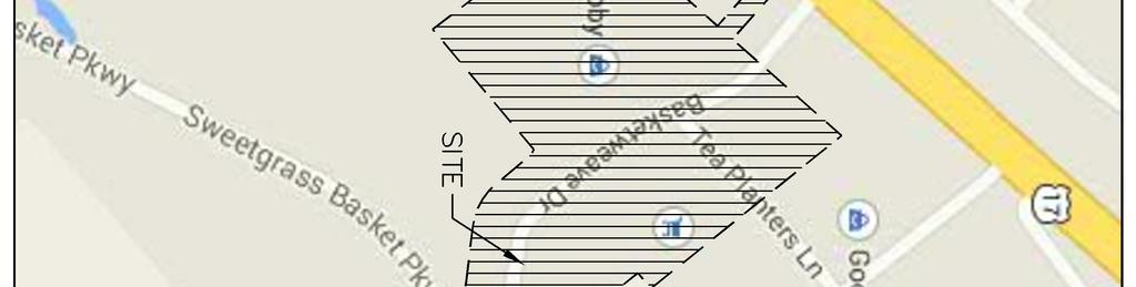
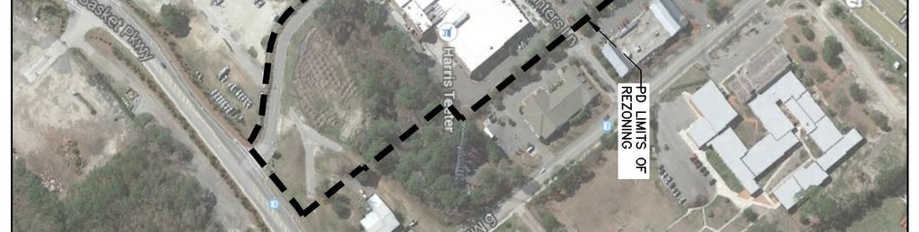
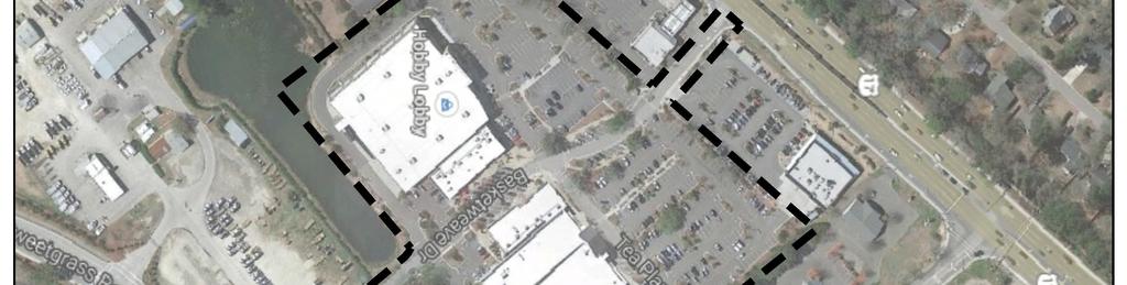
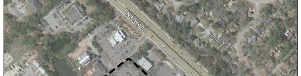
2 Planned Development Guidelines Six Mile Market Place January 21, 2015 Table of contents Page I. General Description and Statement of Purpose 3 II. Workforce Housing III. Sketch Plan..4 IV. PD Land Uses, Program, and Maximums V. Development Regulations..5-7 VI. Appendices..7 a. Site Location Map b. Tax Maps c. Sketch Plans d. Aerial e. Conceptual Rendering f. Impact Assessment (under separate cover) g. Traffic Study (under separate cover) 2
3 Planned Development Guidelines Six Mile Market Place January 21, 2015 I. GENERAL SCRIPTION AND STATEMENT OF PURPOSE This PD Document shall apply to TMS#s , , , and The Six Mile Market Place Mixed Use tract is currently composed of 4 parcels totaling acres within the Town of Mount Pleasant. All parcels to be included in the PD are currently zoned AB. The Town s Comprehensive Plan designates these parcels for Commercial Use. The PD will utilize the Town s PD-MU-SR standards which allow a maximum density of 12 DU/AC, requires a mixed use center, and requires 5% open space which may include urban parks and plazas. The purpose of this PD is to create a flexible mixed use plan that incorporates multi-family and work force housing designed around central pedestrian gathering spaces and service based retail to promote walkability, respect adjacent settlement patterns, utilizes master planned detention, is economically viable, and creates a walkable community that captures daily automobile trips and features a self-imposed workforce housing component. Visitors and residents will not be able to distinguish workforce vs. market rate units from the exterior of the residential buildings. II. WORKFORCE HOUSING Goals: The provision of workforce housing is important to economic development in that the availability of affordable housing helps attract and retain essential workers. Mixed-use, mixed-income developments are important to the viability of the community as a whole. Providing a variety of housing types for households with diverse incomes in proximity to employment opportunities offers a variety of benefits to the community, including reduced traffic congestion and creation of a sense of place and pride in the community. The mulit-family with a workforce component at Six Mile Market Place fulfills one of the Target Strategies of the comprehensive plan by providing work force and life cycle housing units. It also will serve to provide appropriate infill housing that will help attract an increasingly diverse population, promoting and supporting a stable local workforce, and reducing traffic congestion. While high home ownership is generally a community strength, providing adequate rental housing options is important for retaining young adults in the community and for providing workforce housing options. Implementation Strategy: 3
4 Planned Development Guidelines Six Mile Market Place January 21, 2015 The partners of Six Mile Market place have been approved by the SC Community Loan Fund (SCCLF) for a Pre-Development Loan. As one of conditions of the SCCLF loan, they will require a deed restriction of 10% of the residential rental units for 10 years at 120% AMI. These deed restrictions will be defined and administered by SCCLF. This will be a self-imposed deed restriction by the developer. III. SKETCH PLAN A. A Sketch Plan has been included in the appendices of this document and is intended to illustrate design intent for The Six Mile Marketplace Planned Development. The sketch should be used as a guide for the proposed new development at Six Mile Market Place. Design is an iterative process and minor PD modifications to the sketch plan and PD text will be subject to approval by TOMP Planning Staff. Minor modifications are considered any change that does not increase the square footage and development maximums or reduce the minimum amount of open space defined in the PD. PD modifications will not change the proposed uses defined in this PD document. Minor modifications include but are not limited to: text amendments that do not exceed the development maximums defined below, site layout modifications, adjustments to building footprints not to exceed maximums, multi-family unit matrix modification to number and type of unit and square footage. IV. PD LAND US, PROGRAM, AND MAIMUMS A. LAND US Allowable land uses shall include all those uses specified in Area Wide Business: 1. Multi Family rental community with a workforce housing component including associated leasing center, carriage houses, garages, designated storage rooms for residents and staff members, and amenities. 2. Commercial uses as defined by AB including new and existing space. 3. Mixed use buildings 4. Public and Private Amenities a. Bike Barn: bike storage and gathering space b. Improved CARTA stop for Six Mile Market Place (see exhibit) c. Public Gathering Spaces d. Outdoor dining and display areas e. Dogwash B. CURRENT VELOPMENT PROGRAM The current development program includes the following quantities: 1. Multi-family 92 Units 2. Mixed-Use Commercial 1,800 sf 3. Existing Commercial 126,060 sf. 4
5 Planned Development Guidelines Six Mile Market Place January 21, 2015 C. VELOPMENT MAIMUMS Development maximums are provided to allow flexibility as the market changes. 1. Multi-family a. Multi-family Housing will be limited to 12 units per acre as stated in the PD-MU-SR. The Six Mile Market Place PD will be limited to 92 Workforce and market rate housing units. Ten percent of the units will be deed restricted as defined in the workforce housing section of this PD. The maximum achievable number of multifamily units under this PD could be 171 units. This PD will be restricted to 92 residential units total. This is 53.8% of the achievable residential unit density. 2. Commercial a. Existing Commercial 126,060 sf Proposed Mixed Use 1,800 sf *Total Maximum for all commercial buildings: 127,860 sf V. VELOPMENT RULATIONS A. LOT CRITERIA CHART All lots must conform to dimensional, density, and zoning requirements as found in the following chart: MULTI-FAMILY COMMERCIAL USE Min. Front Yd. Setback (ft.) 0' 0' Min. Side Yd. Setback (ft.) 5' 5' Min. Rear Yd. Setback (ft.) 10' 10' Accessory Building side and rear setback (ft.) 5' 5' Maximum Height** 50' 50' Building Coverage (Max. %) No Maximum No Maximum Minimum Lot Area (square feet) No Maximum No Maximum ** All parcels included in the PD are currently allowed 50 in height. NOTE: Setbacks are not required along internal property lines for parcels included in PD 5
6 Planned Development Guidelines Six Mile Market Place January 21, 2015 B. LOT CRITERIA CHART Parking must meet the following criteria: 1. Parking Minimums to be: a. Minimum parking for the Multi Family shall be 1.5 spaces per unit (this includes garage spaces) b. Minimum parking for proposed retail will be 4 spaces per 1,000 sf c. Minimum parking for Office to be 1 space per 300 s.f. * Proposed MF Ratio 1.86 spaces per unit 2. ULI shared parking calculations shall be allowed when a mix of uses are located adjacent to a common parking lot or on-street spaces. Calculations will be subject to review and approval by TOMP Planning Staff. 3. On-street angled and parallel parking to be allowed in both public Rights of Way and private streets internal to the PD boundaries. 4. On street parking may be used to satisfy off-street parking requirements, but may not be double counted. C. BUFFERS Buffers must meet the following Criteria 1. A 10 type A buffer will be required between the multi-family buildings and parcels not included in the PD. Existing vegetation may satisfy some or all of the planting requirements if determined sufficient by staff. 2. No buffer shall be required where the PD boundary is adjacent to commercial properties. 3. No buffers will be required between uses internal to the PD 4. A buffer enhancement will be provided along the property line separating the TOMP Public Works Facility and Basket Weave Drive D. SUBDIVISION 1. Subdivision may occur within the PD boundary. Subdivision may utilize private access easements in lieu of public Rights of Way for ingress and egress. E. TRE 1. Two palms may be provided in lieu of a required parking lot canopy tree in certain accent points and tight planting beds, subject to approval of TOMP Planning Staff. Tree removal and mitigation would be subject to the TOMP tree ordinance. F. STREETS AND DRAINAGE 1. Internal streets may be Public Rights of Way or Private Streets. 6
7 Planned Development Guidelines Six Mile Market Place January 21, Drainage for the site has been accommodated through a detention master plan. No additional onsite detention or water quality measures will be required. 3. Pedestrian interconnectivity shall be provided throughout the site by sidewalks and walking trails. Commercial uses are within a 30 sec to 1 minute walk from the residential component. G. SIGNAGE Signs will be regulated per the town of Mount Pleasant code of ordinances. The existing monument sign will be relocated and may be placed in the buffer along Hungry Neck. H. OPEN SPACE A connected system of sidewalks, courtyards, squares, and urban plazas is provided throughout the development. A bike barn to house bikes and serve as a gathering place will link the mixed-use retail and the multifamily to the existing center. A CARTA bus stop should be integrated into the center if supported by CARTA.. Open space is calculated as 5% of the gross acreage. The proposed open space plan meets or exceeds the required open space. Open space shall include urban parks, plazas, squares, walking trails, or land areas retained for use as active or passive recreation. Open space areas should be accessible to pedestrians. Open space areas intended for active or passive recreation use shall be of sufficient size so as to constitute meaningful and usable space. Open space areas may include high ground and wetland buffer areas. The size and location of open space and useable open space shown within the Open Space Plan included in this document are subject to adjustment; however, these spaces will remain in excess of the required minimums. See Appendix for Conceptual Open Space Plan. I. PUBLIC TRANSPORTATION The Town of Mount Pleasant has recommended in the Comprehensive plan to focus locating workforce housing near an existing or planned center of employment and near everyday services to ensure that both workforce and senior housing has access to public transportation and bike and pedestrian facilities. The PD for Six Mile Market Place includes a Bike Barn with public storage and repair facilities, as well as direct access to the Sweetgrass Parkway Multi-use path, and existing CARTA Route 40 bus stop. The Route 40 unimproved bus stop is adjacent to the Multi-family component at the corner of Sweet Grass Basket Parkway and Basket Weave Drive. The developer has agreed to provide a new bus shelter prior to completion of construction on the Multi- Family units if this PD is approved. 7
8 Planned Development Guidelines Six Mile Market Place January 21, 2015 APPENDIC 8
9

10 1 of 2 1/20/ :16 AM TMS#: Charleston County, South Carolina Copyright 2004 Charleston County GIS 4045 Bridge View Drive North Charleston, SC PARCEL NUMBER : PARCEL ID: STREET NUMBER: 2195 STREET NAME: TEA PLANTER LN PROP UNIT: PROP CITY: PROP ZIP: SITE NAME: HARRIS TEETER GENERAL USE: RTL MOBILE HOM: 0 SUBDIVISION: SNEE FARM LAL SCRIPTION: PART C-2 RIDUAL LGL HI ACR: LGL MAR ACR: 0 LGL WATER ACR: 0 LGL SWAMP ACR: 0 LGL TOTAL ACR: TA DISTRICT: 21 JURISDICTION: CTA PLAT BOOK: V-76 OWNER ON 1ST: SI MILE INVTMENTS LLC OWNER2 ON 1ST:
11 2 of 2 1/20/ :16 AM CURRENT OWNER1: CURRENT OWNER2: SALE DATE: 12/23/2008 BOOK: WILL CO: WILL DATE: C O NAME: MAIL STREET NUMBER: 0 MAIL STREET NAME: PO BO 1785 MAIL UNIT: MAIL CITY: MT PLEASANT MAIL STATE: SC MAIL ZIP: MAIL COUNTRY: MAIL POSTAL CO: SALE PRICE: MULT LOT: 0 SPLIT CO: MLOD GROUP: FINAL VALUE: BUILD COUNT: 3 AG USE VAL: 0 AG MARKET TOT: 0 LR APPROVE: N YEAR BUILT: 0 BROOMS: 0 FULL BATHS: 0 THREE QTR BATHS: 0 HALF BATHS: 0 TOTAL FINISH AREA: 0 LIVING AREA: 0 CONDO-BROOM: 0 CONDO FULL BATH: 0 CONDO H-BATH: 0 CAP LR VAL: 0 CAP AE VALUE: 0 CAP OTHER VALUE:

12 1 of 2 1/20/ :17 AM TMS#: Charleston County, South Carolina Copyright 2004 Charleston County GIS 4045 Bridge View Drive North Charleston, SC PARCEL NUMBER : PARCEL ID: STREET NUMBER: 0 STREET NAME: HUNGRYNECK PROP UNIT: PROP CITY: PROP ZIP: SITE NAME: GENERAL USE: VCC MOBILE HOM: 0 SUBDIVISION: BOONE HALL LAL SCRIPTION: PARCEL A LGL HI ACR: 2.99 LGL MAR ACR: 0 LGL WATER ACR: 0 LGL SWAMP ACR: 0 LGL TOTAL ACR: 2.99 TA DISTRICT: 21 JURISDICTION: MUE PLAT BOOK: L09230 OWNER ON 1ST: TOWN OF MOUNT PLEASANT OWNER2 ON 1ST:
13 2 of 2 1/20/ :17 AM CURRENT OWNER1: CURRENT OWNER2: SALE DATE: BOOK: B WILL CO: WILL DATE: C O NAME: MAYOR JOHN DODDS JR MAIL STREET NUMBER: 0 MAIL STREET NAME: PO BO 745 MAIL UNIT: MAIL CITY: MOUNT PLEASANT MAIL STATE: SC MAIL ZIP: MAIL COUNTRY: MAIL POSTAL CO: SALE PRICE: 0 MULT LOT: 0 SPLIT CO: Y MLOD GROUP: FINAL VALUE: 0 BUILD COUNT: 0 AG USE VAL: 0 AG MARKET TOT: 0 LR APPROVE: N YEAR BUILT: 0 BROOMS: 0 FULL BATHS: 0 THREE QTR BATHS: 0 HALF BATHS: 0 TOTAL FINISH AREA: 0 LIVING AREA: 0 CONDO-BROOM: 0 CONDO FULL BATH: 0 CONDO H-BATH: 0 CAP LR VAL: 0 CAP AE VALUE: 0 CAP OTHER VALUE: 0

14 1 of 2 1/20/ :19 AM TMS#: Charleston County, South Carolina Copyright 2004 Charleston County GIS 4045 Bridge View Drive North Charleston, SC PARCEL NUMBER : PARCEL ID: STREET NUMBER: 0 STREET NAME: HUNGRYNECK PROP UNIT: PROP CITY: PROP ZIP: SITE NAME: GENERAL USE: UND MOBILE HOM: 0 SUBDIVISION: BOONE HALL LAL SCRIPTION: PARCEL B-1 LGL HI ACR: 0 LGL MAR ACR: 0 LGL WATER ACR: 0 LGL SWAMP ACR: 0 LGL TOTAL ACR: 0 TA DISTRICT: 21 JURISDICTION: CTA PLAT BOOK: L09230 OWNER ON 1ST: SI MILE INVTMENTS LLC OWNER2 ON 1ST:
15 2 of 2 1/20/ :19 AM CURRENT OWNER1: CURRENT OWNER2: SALE DATE: 5/15/2009 BOOK: WILL CO: WILL DATE: C O NAME: MAIL STREET NUMBER: 0 MAIL STREET NAME: PO BO 1785 MAIL UNIT: MAIL CITY: MOUNT PLEASANT MAIL STATE: SC MAIL ZIP: MAIL COUNTRY: MAIL POSTAL CO: SALE PRICE: MULT LOT: 2 SPLIT CO: Y MLOD GROUP: FINAL VALUE: 300 BUILD COUNT: 0 AG USE VAL: 0 AG MARKET TOT: 0 LR APPROVE: YEAR BUILT: 0 BROOMS: 0 FULL BATHS: 0 THREE QTR BATHS: 0 HALF BATHS: 0 TOTAL FINISH AREA: 0 LIVING AREA: 0 CONDO-BROOM: 0 CONDO FULL BATH: 0 CONDO H-BATH: 0 CAP LR VAL: 0 CAP AE VALUE: 0 CAP OTHER VALUE: 300

16 1 of 2 1/20/ :20 AM TMS#: Charleston County, South Carolina Copyright 2004 Charleston County GIS 4045 Bridge View Drive North Charleston, SC PARCEL NUMBER : PARCEL ID: STREET NUMBER: 0 STREET NAME: ACCE TO HUNGRYNECK PROP UNIT: PROP CITY: PROP ZIP: SITE NAME: GENERAL USE: UND MOBILE HOM: 0 SUBDIVISION: BOONE HALL LAL SCRIPTION: PARCEL B LGL HI ACR: 0.29 LGL MAR ACR: 0 LGL WATER ACR: 0 LGL SWAMP ACR: 0 LGL TOTAL ACR: 0.29 TA DISTRICT: 21 JURISDICTION: CTA PLAT BOOK: L09230 OWNER ON 1ST: SI MILE INVTMENTS LLC OWNER2 ON 1ST:
17 2 of 2 1/20/ :20 AM CURRENT OWNER1: CURRENT OWNER2: SALE DATE: 5/15/2009 BOOK: WILL CO: WILL DATE: C O NAME: MAIL STREET NUMBER: 0 MAIL STREET NAME: PO BO 1785 MAIL UNIT: MAIL CITY: MOUNT PLEASANT MAIL STATE: SC MAIL ZIP: MAIL COUNTRY: MAIL POSTAL CO: SALE PRICE: MULT LOT: 2 SPLIT CO: Y MLOD GROUP: FINAL VALUE: BUILD COUNT: 0 AG USE VAL: 0 AG MARKET TOT: 0 LR APPROVE: YEAR BUILT: 0 BROOMS: 0 FULL BATHS: 0 THREE QTR BATHS: 0 HALF BATHS: 0 TOTAL FINISH AREA: 0 LIVING AREA: 0 CONDO-BROOM: 0 CONDO FULL BATH: 0 CONDO H-BATH: 0 CAP LR VAL: 0 CAP AE VALUE: 0 CAP OTHER VALUE: 81000
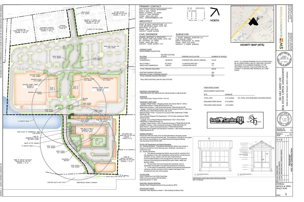
18 PROPERTY INFORMATION TMS# , , , & ACREAGE Total Project Area / Scope of Work: ac ADJACENT LAND US to North: Village Center - Shopping Center and Cracker Barrel = (AB-2) Areawide Business-2 TMS# & 245 Nationwide Insurance = (AB) Areawide Business TMS# to East: Goodwill and East Cooper Community Outreach (ECCO) = (AB) Area Wide Business TMS# , 206, & 275 Bellsouth Radio Tower = (County PI-2) County Public Institutional-2 TMS# Town of Mount Pleasant Fire Department = (PI-2) Public Institutional TMS# to South: Town of Mount Pleasant Maintenance Yard = (PI-2) Public Institutional-2 TMS# to West: Village Center = (AB-2) Areawide Business-2 TMS# Kangaroo Express = (AB-2) Areawide Business-2 TMS# Baker Motors = (AB-2) Areawide Business-2 TMS# Sanctuary Hall & Gardens and Springview Academy = (AB) Areawide Business TMS# VICINITY MAP (NTS) ZONING DISTRICT Project lies within the limits of the Six Mile Marketplace Shopping Center (currently zoned Areawide Business AB). The proposed re-zoning for the project site will be to incorporated in to a unified Planned Development-Mixed Use-Suburban-Rural (PD-MU-SR). PD-MU-SR Classification and District Standards: (a) General standards. This planned development district must contain a mixture of at least two of the following uses: residential, commercial, or institutional uses. (b) Specific standards. 1. This planned development district may provide for variations from the regulations of the other established zoning districts concerning use, setbacks, lot size, density, bulk and other requirements to accommodate flexibility in the arrangement of uses for the general purpose of promoting and protecting the public health, safety and general welfare. 2. The permitted uses and development standards must be specifically enumerated in the planned development ordinance. 3. To the extent not specifically modified by the planned development ordinance, all other provisions of this chapter shall apply to the development and use of the property. VAN NO PARK ING PARC EL PICK- UP FLOOD ZONE Zone Scaled from the FEMA Flood Map FIRM Community panel # 45019C0529J, Dated November 17, 2004 SANITARY SER DISPOSAL Sanitary Sewer Disposal service will be provided by MPW. PROTECT TRE Protected Trees depicted on sheet C3 - Site Existing Conditions Plan. SITE LIGHTING NOTE SITE LIGHTING SHALL BE PROVID BY THE OWNER/VELOPER AND SIGN PER THE TOWN'S ORDINANCE FOR APPEARANCE, MOUNTING HEIGHT, AND PHOTOMETRICS (SEE ATTACH LIGHTING PLANS) 1978 PRIMARY CONTACT CIVIL ENGINEER ARCHITECT SURVEYOR #. Ac # / 21 /15
 Areawide Business TMS# 558-00-00-205 to East: Goodwill and East Cooper Community Outreach (ECCO) = (AB) Area Wide Business TMS# 558-00-00-553, 206, & 275 Bellsouth Radio")
19 EFO P P EU EU EU P 1978 VAN NO PA RKIN G PARC EL PI ET CK-U P ERD ADJACENT LAND US to North: Village Center - Shopping Center and Cracker Barrel = (AB-2) Areawide Business-2 TMS# & 245 Nationwide Insurance = (AB) Areawide Business TMS# to East: Goodwill and East Cooper Community Outreach (ECCO) = (AB) Area Wide Business TMS# , 206, & 275 Bellsouth Radio Tower = (County PI-2) County Public Institutional-2 TMS# Town of Mount Pleasant Fire Department = (PI-2) Public Institutional TMS# to South: Town of Mount Pleasant Maintenance Yard = (PI-2) Public Institutional-2 TMS# to West: Village Center = (AB-2) Areawide Business-2 TMS# Kangaroo Express = (AB-2) Areawide Business-2 TMS# Baker Motors = (AB-2) Areawide Business-2 TMS# Sanctuary Hall & Gardens and Springview Academy = (AB) Areawide Business TMS# ERD ARCHITECT VAN ET ACREAGE Total Project Area / Scope of Work: ac ERD ET CIVIL ENGINEER ET SURVEYOR ZONING DISTRICT Project lies within the limits of the Six Mile Marketplace Shopping Center (currently zoned Areawide Business AB). The proposed re-zoning for the project site will be to incorporated in to a unified Planned Development-Mixed Use-Suburban-Rural (PD-MU-SR). T PD-MU-SR Classification and District Standards: (a) General standards. This planned development district must contain a mixture of at least two of the following uses: residential, commercial, or institutional uses. (b) Specific standards. 1. This planned development district may provide for variations from the regulations of the other established zoning districts concerning use, setbacks, lot size, density, bulk and other requirements to accommodate flexibility in the arrangement of uses for the general purpose of promoting and protecting the public health, safety and general welfare. 2. The permitted uses and development standards must be specifically enumerated in the planned development ordinance. 3. To the extent not specifically modified by the planned development ordinance, all other provisions of this chapter shall apply to the development and use of the property. ET ERD DW R/ LE EA NK R AR RI SP RISE ERD ERD ERD ERD ERD T T PROPERTY INFORMATION TMS# , , , & ET STO P PRIMARY CONTACT ERD ET ' VAN EFM FLOOD ZONE Zone Scaled from the FEMA Flood Map FIRM Community panel # 45019C0529J, Dated November 17, 2004 SANITARY SER DISPOSAL Sanitary Sewer Disposal service will be provided by MPW. PROTECT TRE Protected Trees depicted on sheet 3 - Site Existing Conditions Plan. EFM EFM EFM EFM EFM EFM EFM 2013 M 35 VICINITY MAP (NTS) 1 / 21 /15
20 VICINITY MAP (NTS) PROPERTY INFORMATION TMS# ACREAGE Total Project Area / Scope of Work: 2.99 ac ADJACENT LAND US to North: Village Center - Shopping Center and Cracker Barrel = (AB-2) Areawide Business-2 TMS# & 245 Nationwide Insurance = (AB) Areawide Business TMS# to East: Goodwill and East Cooper Community Outreach (ECCO) = (AB) Area Wide Business TMS# , 206, & 275 Bellsouth Radio Tower = (County PI-2) County Public Institutional-2 TMS# Town of Mount Pleasant Fire Department = (PI-2) Public Institutional TMS# to South: Town of Mount Pleasant Maintenance Yard = (PI-2) Public Institutional-2 TMS# to West: Village Center = (AB-2) Areawide Business-2 TMS# Kangaroo Express = (AB-2) Areawide Business-2 TMS# Baker Motors = (AB-2) Areawide Business-2 TMS# Sanctuary Hall & Gardens and Springview Academy = (AB) Areawide Business TMS# ZONING DISTRICT Project lies within the limits of the Six Mile Marketplace Shopping Center (currently zoned Areawide Business AB). The proposed re-zoning for the project site will be to incorporated in to a unified Planned Development-Mixed Use-Suburban-Rural (PD-MU-SR). / 21 / 1 15 PRIMARY CONTACT ARCHITECT CIVIL ENGINEER SURVEYOR PD-MU-SR Classification and District Standards: (a) General standards. This planned development district must contain a mixture of at least two of the following uses: residential, commercial, or institutional uses. (b) Specific standards. 1. This planned development district may provide for variations from the regulations of the other established zoning districts concerning use, setbacks, lot size, density, bulk and other requirements to accommodate flexibility in the arrangement of uses for the general purpose of promoting and protecting the public health, safety and general welfare. 2. The permitted uses and development standards must be specifically enumerated in the planned development ordinance. 3. To the extent not specifically modified by the planned development ordinance, all other provisions of this chapter shall apply to the development and use of the property. FLOOD ZONE Zone Scaled from the FEMA Flood Map FIRM Community panel # 45019C0529J, Dated November 17, 2004 SANITARY SER DISPOSAL Sanitary Sewer Disposal service will be provided by MPW. PROTECT TRE Protected Trees shown on this plan.
21 1978 TM SO S# UT 55 HE 8- RN 00 BE -0 L 0- L 10 9 SI TO W N TM O S# F M 55 OU 8- NT 00 PL -0 E 0- AS 11 AN 0 T VICINITY MAP (NTS) MI LE TM IN P V 55 ARC T 2. E ME L 0 A NT AC 0S, RE 00 LL S -9 C 19 S# TO TM S# 5 W TM N O S# F M 55 OU 8- NT 00 P -0 LE 0- AS 92 A 6 NT PA R CE L 29 0 AC 0- B RE 00 S TM S# PA 5 RC EL BAC 1 RE 00 S / 21 /15 PRIMARY CONTACT ARCHITECT CIVIL ENGINEER SURVEYOR
 514.24 1.")


22 PRIMARY CONTACT ARCHITECT CIVIL ENGINEER SURVEYOR VICINITY MAP (NTS) PARKING CHART VELOPMENT QUANTITI BUILDING EISTING COMMERCIAL* MULTI-FAMILY MI-USE COMMERCIAL SQUARE FOOTAGE & UNITS 128,560 SF 92 UNITS 1,800 SF PARKING CALCULATION NUMBER OF SPAC 4 SPAC PER 1,000 SF (GRO) SPAC PER UNIT 1 SPACE PER 250 SF NOTE : ULI SHAR PARKING CALCULATIONS SHALL BE ALLOW WHEN A MI OF US ARE LOCAT ADJACENT TO A COMMON PARKING LOT OR ON-STREET SPAC, CALCULATIONS WILL BE SUBJECT TO REVI AND APPROVAL BY TOMP STAFF TOTAL PARKING REQUIR EISTING PARKING PROVID N MULTI-FAMILY PARKING SPAC TOTAL PARKING SPAC PROVID VAN EL PI G PARC RKIN NO PA M CK-U P *INCLUS EISTING 2,500 SF GAS STATION OPEN SPACE CHART PROPERTY INFORMATION TMS# , , , & DW R/ EA LE AR NK R RI SE SP RI ACREAGE Total Project Area / Scope of Work: ac ADJACENT LAND US to North: Village Center - Shopping Center and Cracker Barrel = (AB-2) Areawide Business-2 TMS# & 245 Nationwide Insurance = (AB) Areawide Business TMS# to East: Goodwill and East Cooper Community Outreach (ECCO) = (AB) Area Wide Business TMS# , 206, & 275 Bellsouth Radio Tower = (County PI-2) County Public Institutional-2 TMS# Town of Mount Pleasant Fire Department = (PI-2) Public Institutional TMS# to South: Town of Mount Pleasant Maintenance Yard = (PI-2) Public Institutional-2 TMS# to West: Village Center = (AB-2) Areawide Business-2 TMS# Kangaroo Express = (AB-2) Areawide Business-2 TMS# Baker Motors = (AB-2) Areawide Business-2 TMS# Sanctuary Hall & Gardens and Springview Academy = (AB) Areawide Business TMS# VELOPMENT QUANTITI SITE ACREAGE TOTAL SITE ACR REQUIR OPEN SPACE 0.72 ACR PROVID OPEN SPACE 1.35 ACR 1978 ZONING DISTRICT Project lies within the limits of the Six Mile Marketplace Shopping Center (currently zoned Areawide Business AB). The proposed re-zoning for the project site will be to incorporated in to a unified Planned Development-Mixed Use-Suburban-Rural (PD-MU-SR). PD-MU-SR Classification and District Standards: (a) General standards. This planned development district must contain a mixture of at least two of the following uses: residential, commercial, or institutional uses. (b) Specific standards. 1. This planned development district may provide for variations from the regulations of the other established zoning districts concerning use, setbacks, lot size, density, bulk and other requirements to accommodate flexibility in the arrangement of uses for the general purpose of promoting and protecting the public health, safety and general welfare. 2. The permitted uses and development standards must be specifically enumerated in the planned development ordinance. 3. To the extent not specifically modified by the planned development ordinance, all other provisions of this chapter shall apply to the development and use of the property. FLOOD ZONE Zone Scaled from the FEMA Flood Map FIRM Community panel # 45019C0529J, Dated November 17, 2004 SANITARY SER DISPOSAL Sanitary Sewer Disposal service will be provided by MPW. PROTECT TRE Protected Trees depicted on sheet 3 - Site Existing Conditions Plan. (5% TOTAL SITE REQUIR FOR OPEN SPACE) PROPOS CARTA BUS SHELTER ELEVATION NOT TO SCALE / 21 /15
 Areawide Business-2 TMS# 558-00-00-203 & 245 Nationwide Insurance = (AB) Areawide Business TMS#")
 Public Institutional TMS# 558-00-00-926 to South: Town of Mount Pleasant Maintenance Yard = (PI-2) Public Institutional-2 TMS#")
23 PROPERTY INFORMATION TMS# VICINITY MAP (NTS) ACREAGE Total Project Area / Scope of Work: 2.99 ac ADJACENT LAND US to North: Village Center - Shopping Center and Cracker Barrel = (AB-2) Areawide Business-2 TMS# & 245 Nationwide Insurance = (AB) Areawide Business TMS# to East: Goodwill and East Cooper Community Outreach (ECCO) = (AB) Area Wide Business TMS# , 206, & 275 Bellsouth Radio Tower = (County PI-2) County Public Institutional-2 TMS# Town of Mount Pleasant Fire Department = (PI-2) Public Institutional TMS# to South: Town of Mount Pleasant Maintenance Yard = (PI-2) Public Institutional-2 TMS# to West: Village Center = (AB-2) Areawide Business-2 TMS# Kangaroo Express = (AB-2) Areawide Business-2 TMS# Baker Motors = (AB-2) Areawide Business-2 TMS# Sanctuary Hall & Gardens and Springview Academy = (AB) Areawide Business TMS# ZONING DISTRICT Project lies within the limits of the Six Mile Marketplace Shopping Center (currently zoned Areawide Business AB). The proposed re-zoning for the project site will be to incorporated in to a unified Planned Development-Mixed Use-Suburban-Rural (PD-MU-SR). PD-MU-SR Classification and District Standards: (a) General standards. This planned development district must contain a mixture of at least two of the following uses: residential, commercial, or institutional uses. (b) Specific standards. 1. This planned development district may provide for variations from the regulations of the other established zoning districts concerning use, setbacks, lot size, density, bulk and other requirements to accommodate flexibility in the arrangement of uses for the general purpose of promoting and protecting the public health, safety and general welfare. 2. The permitted uses and development standards must be specifically enumerated in the planned development ordinance. 3. To the extent not specifically modified by the planned development ordinance, all other provisions of this chapter shall apply to the development and use of the property. NOT : FLOOD ZONE Zone Scaled from the FEMA Flood Map FIRM Community panel # 45019C0529J, Dated November 17, 2004 SANITARY SER DISPOSAL Sanitary Sewer Disposal service will be provided by MPW. PRIMARY CONTACT PROTECT TRE Protected Trees depicted on sheet 3 - Site Existing Conditions Plan. SI MILE MULTI-FAMILY HOUSING ARCHITECT CIVIL ENGINEER PARKING RATIO = 1.86 SPAC/UNIT SURVEYOR SITE LIGHTING SHALL BE PROVID BY THE OWNER/VELOPER AND SIGN PER THE TOWN'S REQUIREMENTS FOR APPEARANCE, MOUNTING HEIGHT, AND PHOTOMETRICS. 2. ALL PROTECT, SIGNIFICANT, AND HISTORIC TRE WILL BE MITIGAT PER TOWN OF MOUNT PLEASANT ORDINANCE. 1 / 21 /15
 Areawide Business-2 TMS# 558-00-00-203 & 245 Nationwide Insurance = (AB) Areawide Business TMS#")
24 VICINITY MAP (NTS) PROPERTY INFORMATION TMS# ACREAGE Total Project Area / Scope of Work: 2.99 ac ADJACENT LAND US to North: Village Center - Shopping Center and Cracker Barrel = (AB-2) Areawide Business-2 TMS# & 245 Nationwide Insurance = (AB) Areawide Business TMS# to East: Goodwill and East Cooper Community Outreach (ECCO) = (AB) Area Wide Business TMS# , 206, & 275 Bellsouth Radio Tower = (County PI-2) County Public Institutional-2 TMS# Town of Mount Pleasant Fire Department = (PI-2) Public Institutional TMS# to South: Town of Mount Pleasant Maintenance Yard = (PI-2) Public Institutional-2 TMS# to West: Village Center = (AB-2) Areawide Business-2 TMS# Kangaroo Express = (AB-2) Areawide Business-2 TMS# Baker Motors = (AB-2) Areawide Business-2 TMS# Sanctuary Hall & Gardens and Springview Academy = (AB) Areawide Business TMS# ZONING DISTRICT Project lies within the limits of the Six Mile Marketplace Shopping Center (currently zoned Areawide Business AB). The proposed re-zoning for the project site will be to incorporated in to a unified Planned Development-Mixed Use-Suburban-Rural (PD-MU-SR). PRIMARY CONTACT PD-MU-SR Classification and District Standards: (a) General standards. This planned development district must contain a mixture of at least two of the following uses: residential, commercial, or institutional uses. (b) Specific standards. 1. This planned development district may provide for variations from the regulations of the other established zoning districts concerning use, setbacks, lot size, density, bulk and other requirements to accommodate flexibility in the arrangement of uses for the general purpose of promoting and protecting the public health, safety and general welfare. 2. The permitted uses and development standards must be specifically enumerated in the planned development ordinance. 3. To the extent not specifically modified by the planned development ordinance, all other provisions of this chapter shall apply to the development and use of the property. / 21 / 1 15 ARCHITECT CIVIL ENGINEER FLOOD ZONE Zone Scaled from the FEMA Flood Map FIRM Community panel # 45019C0529J, Dated November 17, 2004 SANITARY SER DISPOSAL Sanitary Sewer Disposal service will be provided by MPW. PROTECT TRE Protected Trees depicted on sheet 3 - Site Existing Conditions Plan. SURVEYOR
25
26
SUBJECT PARCEL(S) Property Owner(s) TMS Number Approximate Acreage Carolina Park Development, LLC
 Property Owner(s) TMS Number Approximate Acreage Carolina Park Development, LLC") Staff Report Special Planning Commission Meeting November 19, 2014 For reference, the Zoning Code and Land Development Regulations are available online. AGENDA ITEM 5c. SKETCH PLAN APPROVAL REQUEST: Request
Staff Report Special Planning Commission Meeting November 19, 2014 For reference, the Zoning Code and Land Development Regulations are available online. AGENDA ITEM 5c. SKETCH PLAN APPROVAL REQUEST: Request
PRIMUS TRACT MOUNT PLEASANT, SOUTH CAROLINA
 DEVELOPMENT GUIDELINES FOR PRIMUS TRACT MOUNT PLEASANT, SOUTH CAROLINA Date February 18, 2015 PLANNING COMMISSION SUBMITTAL Owner/Developer: American Star Development SC, LLC P.O. Box 211 Sullivans Island,
Planning Department Oconee County, Georgia
 Planning Department Oconee County, Georgia STAFF REPORT REZONE CASE #: 6985 DATE: October 31, 2016 STAFF REPORT BY: Andrew C. Stern, Planner APPLICANT NAME: Williams & Associates, Land Planners PC PROPERTY
Staff Report: Date: Applicant: Property Identification: Acreage of Request: Current Zoning of Requested Area: Requested Action: Attached:
 Staff Report: Completed by Jeff Palmer Director of Planning & Zoning Date: November 7, 2018, Updated November 20, 2018 Applicant: Greg Smith, Oberer Land Developer agent for Ronald Montgomery ET AL Property
619. Planned Development District (PD)
") 619. Planned Development District (PD) Intent. The purpose of the Planned Development District (sometimes hereinafter referred to as PD) is to provide opportunities to create more desirable environments
619. Planned Development District (PD) Intent. The purpose of the Planned Development District (sometimes hereinafter referred to as PD) is to provide opportunities to create more desirable environments
PLANNED UNIT DEVELOPMENT & SUBDIVISION STAFF REPORT Date: April 18, 2019
 PLANNED UNIT DEVELOPMENT & SUBDIVISION STAFF REPORT Date: April 18, 2019 DEVELOPMENT NAME SUBDIVISION NAME Springhill Village Subdivision Springhill Village Subdivision LOCATION 4350, 4354, 4356, 4358,
Staff Report: Date: Applicant: Property Identification: Acreage of Request: Current Zoning of Requested Area: Requested Action: Attached:
 Staff Report: Completed by Jeff Palmer Director of Planning & Zoning Date: November 7, 2018 Applicant: Greg Smith, Oberer Land Developer agent for Ronald Montgomery ET AL Property Identification: Frontage
Chapter URBAN VILLAGE ZONING DISTRICTS
 Chapter 20.16 Sections: 20.16.010 Purpose of the Urban Village Zoning Districts 20.16.020 Land Use Regulations for the Urban Village Zoning Districts 20.16.030 Development Standards & Guidelines for the
ARTICLE 759. PD 759. PD 759 was established by Ordinance No , passed by the Dallas City Council on June 27, (Ord. Nos.
 ARTICLE 759. PD 759. SEC. 51P-759.101. LEGISLATIVE HISTORY. PD 759 was established by Ordinance No. 26871, passed by the Dallas City Council on June 27, 2007. (Ord. Nos. 26871; 29304) SEC. 51P-759.102.
LINCOLN COUNTY PLANNING & INSPECTIONS DEPARTMENT
 LINCOLN COUNTY PLANNING & INSPECTIONS DEPARTMENT 302 NORTH ACADEMY STREET, SUITE A, LINCOLNTON, NORTH CAROLINA 28092 704-736-8440 OFFICE 704-736-8434 INSPECTION REQUEST LINE 704-732-9010 FAX To: Board
ARTICLE OPTIONAL METHOD REGULATIONS
 ARTICLE 59-6. OPTIONAL METHOD REGULATIONS DIV. 6.1. MPDU DEVELOPMENT IN RURAL RESIDENTIAL AND RESIDENTIAL ZONES SEC. 6.1.1. GENERAL REQUIREMENTS... 6 2 SEC. 6.1.2. GENERAL SITE AND BUILDING T PE MIX...
In order to permit maximum applicability of the PUD District, PUD-1 and PUD-2 Districts are hereby created.
 ARTICLE III. PUD ned Unit Development Overlay District 205-128. Purpose. The PUD ned Unit Development Overlay District is intended to provide flexibility in the design of planned projects; to encourage
PLANNED UNIT DEVELOPMENTS (Ordinance No.: 3036, 12/3/07; Repealed & Replaced by Ordinance No.: 4166, 10/15/12)
") 159.62 PLANNED UNIT DEVELOPMENTS (Ordinance No.: 3036, 12/3/07; Repealed & Replaced by Ordinance No.: 4166, 10/15/12) A. PURPOSE 1. General. The Planned Unit Development (PUD) approach provides the flexibility
159.62 PLANNED UNIT DEVELOPMENTS (Ordinance No.: 3036, 12/3/07; Repealed & Replaced by Ordinance No.: 4166, 10/15/12) A. PURPOSE 1. General. The Planned Unit Development (PUD) approach provides the flexibility
CHAPTER34 PRUD - PLANNED RESIDENTIAL UNIT DEVELOPMENT
 CHAPTER34 PRUD - PLANNED RESIDENTIAL UNIT DEVELOPMENT 17-34-1 17-34-2 17-34-3 17-34-4 17-34-5 17-34-6 17-34-7 17-34-8 17-34-9 Purpose Planned Residential Unit Development Defined Planned Residential Unit
PLANNED DEVELOPMENT DISTRICT STANDARDS. Cadence Site
 PLANNED DEVELOPMENT DISTRICT STANDARDS Cadence Site A Planned Development District 1. Statement of General Facts, Conditions and Objectives Property Size: Approximately 57.51 Acres York County Tax Map
Article Optional Method Requirements
 Article 59-6. Optional Method Requirements [DIV. 6.1. MPDU DEVELOPMENT IN RURAL RESIDENTIAL AND RESIDENTIAL ZONES Sec. 6.1.1. General Requirements... 6 2 Sec. 6.1.2. General Site and Building Type Mix...
A. Location. A MRD District may be permitted throughout the County provided it meets the standards established herein.
 752. Multi-Residential District (MRD) The Multi-Residential (MRD) District is intended to provide opportunities for rural, suburban and urban density mixed-residential developments consistent with the
Bowie Marketplace Residential Detailed Site Plan Statement of Justification January 13, 2017 Revised February 2, 1017
 Bowie Marketplace Residential Detailed Site Plan Statement of Justification January 13, 2017 Revised February 2, 1017 Submitted on behalf of: BE Bowie LLC 5410 Edson Lane, Suite 220 Rockville, MD 20852
NORMAN, OKLAHOMA OWNER: RCB BANK APPLICATION FOR 2025 PLAN CHANGE PLANNED UNIT DEVELOPMENT PRELIMINARY PLAT. 12 December 2011 Revised 5 January 2012
 THE VILLAGE AT OAKHURST ADDITION NORMAN, OKLAHOMA OWNER: RCB BANK APPLICATION FOR 2025 PLAN CHANGE PLANNED UNIT DEVELOPMENT PRELIMINARY PLAT 12 December 2011 Revised 5 January 2012 PREPARED BY: THE RIEGER
Medical Marijuana Special Exception Use Information
 Medical Marijuana Special Exception Use Information The Special Exception Use information below is a modified version of the Unified Development Code. It clarifies the current section 5:104 Special Exceptions
Appendix J - Planned Unit Development (PUD)
") Appendix J - Planned Unit Development (PUD) Intent and Purpose The purpose of the PUD is: 1. To provide development that is consistent with the Comprehensive Land Use Plan and promote the goals and objectives
Appendix J - Planned Unit Development (PUD) Intent and Purpose The purpose of the PUD is: 1. To provide development that is consistent with the Comprehensive Land Use Plan and promote the goals and objectives
EXHIBIT D. WRITTEN DESCRIPTION For. TOWNSEND VILLAGE PUD December 23, 2015 (Revised)
") I. PROJECT DESCRIPTION EXHIBIT D WRITTEN DESCRIPTION For TOWNSEND VILLAGE PUD December 23, 2015 (Revised) A. This 7.2 acre single-family residential project is located on the East side of Townsend Boulevard,
I. PROJECT DESCRIPTION EXHIBIT D WRITTEN DESCRIPTION For TOWNSEND VILLAGE PUD December 23, 2015 (Revised) A. This 7.2 acre single-family residential project is located on the East side of Townsend Boulevard,
PROPOSED AMENDMENTS TO THE DERBY ZONING REGULATIONS AUGUST 12, 2008
 ARTICLE II Definitions and word usage 195-7. Definitions and word usage. Modify the following: HOUSING FOR THE ELDERLY OLDER PERSONS Housing in accordance with and as defined in the United States Fair
ORDINANCE NOW THEREFORE, BE IT ENACTED BY THE CITY COMMISSION OF THE CITY OF WINTER GARDEN, FLORIDA, AS FOLLOWS:
 ORDINANCE 12-02 AN ORDINANCE OF THE CITY OF WINTER GARDEN, FLORIDA, AMENDING ARTICLE V OF CHAPTER 118 OF THE WINTER GARDEN CODE OF ORDINANCES ENTITLED PLANNED UNIT DEVELOPMENTS CREATING URBAN VILLAGE PLANNED
ORDINANCE WHEREAS, the adoption of this Ordinance shall not be construed as an admission that the aforesaid claim has merit or is correct; and
 ORDINANCE 12-24 AN ORDINANCE OF THE CITY OF WINTER GARDEN, FLORIDA, REPEALING ORDINANCE 12-02 AND REPLACING IT WITH THE AMENDMENTS TO ARTICLE V OF CHAPTER 118 OF THE WINTER GARDEN CODE OF ORDINANCES CONTAINED
TOWN OF MOUNT PLEASANT, SOUTH CAROLINA PLANNING & DEVELOPMENT COMMITTEE OCTOBER 31, 2016 MINUTES. Municipal Complex, Building A, Public Meeting Room 1
 TOWN OF MOUNT PLEASANT, SOUTH CAROLINA PLANNING & DEVELOPMENT COMMITTEE OCTOBER 31, 2016 MINUTES Municipal Complex, Building A, Public Meeting Room 1 Members Present: Staff Present: Bob Brimmer, Joe Bustos,
ARTICLE 15 - PLANNED UNIT DEVELOPMENT
 Section 15.1 - Intent. ARTICLE 15 - PLANNED UNIT DEVELOPMENT A PUD, or Planned Unit Development, is not a District per se, but rather a set of standards that may be applied to a development type. The Planned
ITEM #6 & 6A. Application #LEGP
 CHANGE OF ZONING FROM SR LOW DENSITY SINGLE FAMILY SUBURBAN RESIDENTIAL TO R2/PD LOW TO MODERATE DENSITY RESIDENTIAL/PLANNED DEVELOPMENT AND APPROVAL OF A PRELMINARY DEVELOPMENT PLAN Application #LEGP-001557-2014
Planning Department Oconee County, Georgia STAFF REPORT
 Planning Department Oconee County, Georgia STAFF REPORT REZONE CASE #: 7332 DATE: November 28, 2017 STAFF REPORT BY: Gabriel Quintas, Planner APPLICANT NAME: Smith Planning Group PROPERTY OWNER: John Hadden
Single Family Residential
 Housing Development Tools Single Family Residential Single Family Residence 1 Current Accessory Apartment Ordinance Single Family Residence 600 Square Foot Accessory Apartment (Net Floor Area) Twice Minimum
LINCOLN COUNTY PLANNING & INSPECTIONS DEPARTMENT
 LINCOLN COUNTY PLANNING & INSPECTIONS DEPARTMENT 302 NORTH ACADEMY STREET, SUITE A, LINCOLNTON, NORTH CAROLINA 28092 704-736-8440 OFFICE 704-736-8434 INSPECTION REQUEST LINE 704-732-9010 FAX To: Board
Cover Letter with Narrative Statement
 Cover Letter with Narrative Statement March 31, 2017 rev July 27, 2017 RE: Rushton Pointe Residential Planned Unit Development Application for Public Hearing for RPUD Rezone PL2015 000 0306 Mr. Eric Johnson,
Conditional Use Permit case no. CU 14-06: Bristol Village Partners, LLC
 PLANNING AND ZONING COMMISSION STAFF REPORT August 7, 2014 Conditional Use Permit case no. CU 14-06: Bristol Village Partners, LLC CASE DESCRIPTION: LOCATION: LEGAL DESCRIPTION: EXISTING LAND USE: ZONING:
UDO Advisory Committee Meeting #3 August 18, 2011
 UDO Advisory Committee Meeting #3 August 18, 2011 Today s s Agenda Welcome Recap of Meeting #2 Overview of Strategy Statement Overview of Zoning Districts What changes and what stays the same? Break Putting
Planning Justification Report
 Planning Justification Report 101 Kozlov Street, Barrie, Ont. Destaron Property Management Ltd. November 2015 Revised February 2017 TABLE OF CONTENTS Page 1.0 INTRODUCTION... 1 2.0 DESCRIPTION OF SUBJECT
PLANNED UNIT DEVELOPMENTS
 PLANNED UNIT DEVELOPMENTS SECTION 9.01 DESCRIPTION AND PURPOSE. A. The purpose of a planned unit development (PUD) is to permit greater flexibility in development than is generally possible under standard
Year. Simply Dental PUD. Town of Fishers Planned Development Ordinance No v
 Simply Dental PUD v. 02.03.14 Town of Fishers Planned Development Ordinance No. 010614 1.01 Declaration, Purpose and Intent, and Permitted Uses Declaration Ordinance No. 010614 (this Ordinance") Adopted:
TOWN OF MOUNT PLEASANT, SOUTH CAROLINA COMMITTEES OF COUNCIL MEETINGS
 TOWN OF MOUNT PLEASANT, SOUTH CAROLINA COMMITTEES OF COUNCIL MEETINGS Municipal Complex Building A - Public Meeting Room 1 100 Ann Edwards Lane, Mount Pleasant, SC ************************** MONDAY, MARCH
LINCOLN COUNTY PLANNING & INSPECTIONS DEPARTMENT
 LINCOLN COUNTY PLANNING & INSPECTIONS DEPARTMENT 302 NORTH ACADEMY STREET, SUITE A, LINCOLNTON, NORTH CAROLINA 28092 704-736-8440 OFFICE 704-736-8434 INSPECTION REQUEST LINE 704-732-9010 FAX To: Board
DEVELOPMENT DEPARTMENT STAFF REPORT STAFF REPORT PUD/DCI BAINBRIDGE MIXED-USE DEVELOPMENT
 DEVELOPMENT DEPARTMENT STAFF REPORT Meeting Date: October 12, 2017 Item #: _PZ-2017-170_ STAFF REPORT PUD/DCI BAINBRIDGE MIXED-USE DEVELOPMENT Request: Project Name: Planned Unit Development (PUD)/ Development
Technology Park Planned Unit Development Technology Park PUD-IP
 Technology Park Planned Unit Development Technology Park PUD-IP Rob Anderson Community Development Director Planned Unit Development Background 2 Planned Unit Development (PUD) means a mixed use redevelopment
ZONING AMENDMENT, PLANNED UNIT DEVELOPMENT & SUBDIVISION STAFF REPORT Date: August 8, 2013
 ZONING AMENDMENT, PLANNED UNIT DEVELOPMENT & SUBDIVISION STAFF REPORT Date: August 8, 2013 NAME SUBDIVISION NAME PV-Magnolia, LLC Twelve Trees Subdivision LOCATION 2860, 2862 and 2866 Pleasant Valley Road
PLANNING COMMISSION REPORT Regular Agenda -Public Hearing Item
 PDP-13-00518 Item No. 3B- 1 PLANNING COMMISSION REPORT Regular Agenda -Public Hearing Item PC Staff Report 2/24/14 ITEM NO. 3B PRELIMINARY DEVELOPMENT PLAN FOR HERE @ KANSAS; 1101 INDIANA ST (SLD) PDP-13-00518:
Article 6: Planned Unit Developments
 LUDC 2013 GARFIELD COUNTY, COLORADO Article 6: Planned Unit Developments ARTICLE 6 PLANNED UNIT DEVELOPMENTS TABLE OF CONTENTS DIVISION 1. GENERAL.... 1 6-101. GENERAL PROVISIONS.... 1 A. Purpose....
PUBLIC NOTICE* Studies Requested: Parking analysis. Other Required Permits: Building Permit, Site Development Permit
 C I T Y O F T A C O M A Planning & Development Services Department 747 Market St, Rm 345 Tacoma, WA 98402 PUBLIC NOTICE* Date of Notification: 1/15/2019 Application Received: 12/03/2018 Application Complete:12/07/2018
Town of Cary, North Carolina Rezoning Staff Report 12-REZ-27 Morris Branch Town Council Public Hearing January 24, 2013
 Town of Cary, North Carolina Rezoning Staff Report 12-REZ-27 Morris Branch Town Council Public Hearing January 24, 2013 REQUEST To amend the Town of Cary Official Zoning Map to rezone approximately 9.0
Financial Impact Statement There are no immediate financial impacts associated with the adoption of this report.
 STAFF REPORT Planning and Development Department Subject: Application by RYC Property to rezone a portion of lands on John Murray Dr. and Megan Lynn Dr. from R2 to R3 and to enter into a Development Agreement
ORDINANCE NO. AN ORDINANCE AMENDING THE ZONING ORDINANCE OF FISHERS, INDIANA 2006
 ORDINANCE NO. AN ORDINANCE AMENDING THE ZONING ORDINANCE OF FISHERS, INDIANA 2006 AN ORDINANCE AMENDING THE ZONING ORDINANCE OF FISHERS, INDIANA 2006. BE IT ORDAINED BY THE TOWN COUNCIL OF THE TOWN OF
McGowin Park, LLC. B-3, Community Business District
 # 10, 11, 12 SUB2014-00024 ZON2014-00500 ZON2014-00501 SUBDIVISION, PLANNED UNIT DEVELOPMENT (East), PLANNED UNIT DEVELOPMENT (West) STAFF REPORT Date: April 3, 2014 DEVELOPMENT NAME LOCATION McGowin Park,
TOWN OF OCEAN ISLE BEACH
 TOWN OF OCEAN ISLE BEACH PLANNED UNIT DEVELOPMENT ORDINANCE ADOPTED IN EFFECT FEBRUARY 13, 2001 This ordinance has been prepared by the Ocean Isle Beach Planning & Inspections Department. Section 66-55.
Marion County Board of County Commissioners
 Marion County Board of County Commissioners Date: 12/29/2015 P&Z: 12/28/2015 BCC: 1/12/2016 Item Number 160113Z Type of Application Rezoning Request From: A-1 (General Agriculture) To: PUD (Planned Unit
110 Grace Drive Preliminary Plan Submittal (section (c))
)") 110 Grace Drive Preliminary Plan Submittal (section 1143.11(c)) 1. Chris Bradley 6760 Colt Court Dublin, OH 43017 2. Dan Hanes Columbus Architectural Studio 614.370.7413 Bryan Lundgren Osborn Engineering
110 Grace Drive Preliminary Plan Submittal (section 1143.11(c)) 1. Chris Bradley 6760 Colt Court Dublin, OH 43017 2. Dan Hanes Columbus Architectural Studio 614.370.7413 Bryan Lundgren Osborn Engineering
CONCEPTUAL MASTER PLAN CHECKLIST Major Land Development Project
 CONCEPTUAL MASTER PLAN CHECKLIST Major Land Development Project To initiate the application, the applicant shall submit to the Administrative Officer: 1. The application review fee, as established by the
ARTICLE 14 PLANNED UNIT DEVELOPMENT (PUD) DISTRICT
 DISTRICT") ARTICLE 14 PLANNED UNIT DEVELOPMENT (PUD) DISTRICT Section 14.01 Intent. It is the intent of this Article to allow the use of the planned unit development (PUD) process, as authorized by the Michigan Zoning
ARTICLE 14 PLANNED UNIT DEVELOPMENT (PUD) DISTRICT Section 14.01 Intent. It is the intent of this Article to allow the use of the planned unit development (PUD) process, as authorized by the Michigan Zoning
Town of Cary, North Carolina Rezoning Staff Report 14-REZ-31 Cary Park PDD Amendment (Waterford II) Town Council Meeting January 15, 2015
 Town Council Meeting January 15, 2015") Town of Cary, North Carolina Rezoning Staff Report 14-REZ-31 Cary Park PDD Amendment (Waterford II) Town Council Meeting January 15, 2015 REQUEST To amend the Town of Cary Official Zoning Map by amending
Town of Cary, North Carolina Rezoning Staff Report 14-REZ-31 Cary Park PDD Amendment (Waterford II) Town Council Meeting January 15, 2015 REQUEST To amend the Town of Cary Official Zoning Map by amending
DEVELOPMENT DEPARTMENT STAFF REPORT STAFF REPORT MCDONALD S ZONING MAP AMENDMENT AND CONCURRENT VARIANCES
 DEVELOPMENT DEPARTMENT STAFF REPORT Meeting Date: October 12, 2017 Item #: _PZ2017-172_ STAFF REPORT MCDONALD S ZONING MAP AMENDMENT AND CONCURRENT VARIANCES Request: Rezone property from MU-BC to CC,
HOUSING ELEMENT GOALS, OBJECTIVES, AND POLICIES
 HOUSING ELEMENT GOALS, OBJECTIVES, AND POLICIES GOAL 1: To promote the preservation and development of high-quality, balanced, and diverse housing options for persons of all income levels throughout the
ARTICLE 3: Zone Districts
 ARTICLE 3: Zone Districts... 3-1 17.3.1: General...3-1 17.3.1.1: Purpose and Intent... 3-1 17.3.2: Districts and Maps...3-1 17.3.2.1: Applicability... 3-1 17.3.2.2: Creation of Districts... 3-1 17.3.2.3:
Oak Cliff Gateway District PD 468
 Oak Cliff Gateway District PD 468 August 21, 2014 2013 Authorized Hearing Authorized Hearing September, 2013 September 12, 2013 City Plan Commission expanded boundaries to represent current Oak Cliff Gateway
Exhibit THIRD AMENDED PUD WRITTEN DESCRIPTION. Willens Claire Lane PUD
 Exhibit D THIRD AMENDED PUD WRITTEN DESCRIPTION Willens Claire Lane PUD Date: May 7, 14 Current Zoning District: PUD Current Land Use Designation: RPI Proposed Zoning District: PUD RE #: 166- I. PROJECT
Unified Development Code
 Unified Development Code City of Keller, Texas Prepared by the City of Keller Community Development Department Adopted: July 7, 2015 Article One Introduction UDC Table of Contents Section 1.01 - Title
EXHIBIT A FOR HAMILTON PLACE RPUD
 EXHIBIT A Regulations for development of the Hamilton Place RPUD shall be in accordance with the contents of this RPUD Document and applicable sections of the LDC and Growth Management Plan (GMP) in effect
Village of Glenview Plan Commission
 Village of Glenview Plan Commission STAFF REPORT May 13, 2014 TO: Chairman and Plan Commissioners CASE #: P2014-037 FROM: Community Development Department CASE MANAGER: Tony Repp, Planner SUBJECT: Final
DISCUSSION DRAFT 1 INTRODUCTORY PROVISIONS
 1 INTRODUCTORY PROVISIONS 1.1 GENERAL...3 Title 3 Authority 3 Applicability 3 Purpose 3 Regulatory Scope 4 Compliance 4 Fines and Penalties 4 Conflicting Provisions 5 Meaning & Intent 5 Text & Graphics
Composition of traditional residential corridors.
 Page 1 of 7 St. Petersburg, Florida, Code of Ordinances >> PART II - ST. PETERSBURG CITY CODE >> Chapter 16 - LAND DEVELOPMENT REGULATIONS >> SECTION 16.20.060. CORRIDOR RESIDENTIAL TRADITIONAL DISTRICTS
PD No. 15 Authorized Hearing
 PD No. 15 Authorized Hearing Community Meeting No. 2 February 19, 2019 6:30 p.m. Hyer Elementary School Cafetorium 8385 Durham St Andrew Ruegg Senior Planner PD No. 15 Authorized Hearing On September 7,
Operating Standards Attachment to Development Application
 Planning & Development Services 2255 W Berry Ave. Littleton, CO 80120 Phone: 303-795-3748 Mon-Fri: 8am-5pm www.littletongov.org Operating Standards Attachment to Development Application 1 PLANNED DEVELOPMENT
PINE RIDGE COMMONS PUD AMEND ORDINANCE NUMBER 99-94
 PINE RIDGE COMMONS PUD AMEND ORDINANCE NUMBER 99-94 Title page of the Planned Unit Development Document, previously attached as Exhibit A to the PUD document of Ordinance Number 99-94, the Pine Ridge commons
ZONING AMENDMENT & SUBDIVISION STAFF REPORT Date: November 3, 2016
 ZONING AMENDMENT & SUBDIVISION STAFF REPORT Date: November 3, 2016 APPLICANT NAME SUBDIVISION NAME David Shumer 5955 Airport Subdivision CITY COUNCIL DISTRICT District 6 5955 Airport Boulevard, 754 Linlen
Exhibit A-1. Piney Creek Bend Planned Development
 Exhibit A-1 Piney Creek Bend Planned Development A. Purpose and Intent The Piney Creek Bend PD is composed of approximately 90.91 acres, as described in Exhibit D (Field Notes). The development of this
Affordable Housing Plan
 Affordable Housing Plan CORDOVA HILLS SPECIAL PLANNING AREA 1 Proposed Project Conwy LLC is the master developer ( Master Developer ) of that certain real property in the County of Sacramento ( County
SECTION 16. "PUD" PLANNED UNIT DEVELOPMENT OVERLAY DISTRICT
 SECTION 6. "PUD" PLANNED UNIT DEVELOPMENT OVERLAY DISTRICT Subsection. Purpose. This district is established to achieve the coordinated integration of land parcels and large commercial and retail establishments
Appendix A: Guide to Zoning Categories Prince George's County, Maryland
 Appendix A: Guide to Zoning Categories Prince George's County, Maryland RESIDENTIAL ZONES 1 Updated November 2010 R-O-S: Reserved Open Space - Provides for permanent maintenance of certain areas of land
ARTICLE 12 PLANNED UNIT DEVELOPMENT DISTRICTS (PUDS) Sec Intent CHARTER TOWNSHIP OF BRIGHTON ZONING ORDINANCE
 Sec Intent CHARTER TOWNSHIP OF BRIGHTON ZONING ORDINANCE") ARTICLE 12 PLANNED UNIT DEVELOPMENT DISTRICTS (PUDS) Sec. 12-01 Intent 1 2 (a) The intent of this Article is to permit the coordinated development on larger sites, protect significant natural features
ARTICLE 12 PLANNED UNIT DEVELOPMENT DISTRICTS (PUDS) Sec. 12-01 Intent 1 2 (a) The intent of this Article is to permit the coordinated development on larger sites, protect significant natural features
Individual Well Individual Septic. Community Well 19. What is the proposed method of sewage disposal? Public. None
 Please Answer the Following Questions: (attach sheet if needed). What type of facility is being proposed? Campground Recreational Vehicle (RV) Park Both 2. What is the total acreage of the proposed facility?
LINCOLN COUNTY PLANNING & INSPECTIONS DEPARTMENT
 LINCOLN COUNTY PLANNING & INSPECTIONS DEPARTMENT 30 NORTH ACADEMY STREET, SUITE A, LINCOLNTON, NORTH CAROLINA 809 704-736-8440 OFFICE 704-736-8434 INSPECTION REQUEST LINE 704-73-900 FAX To: Board of Commissioners
CITY COUNCIL STUDY SESSION MEMORANDUM
 City and County of Broomfield, Colorado To: From: Prepared by: Owner Applicant Property Size Property Location: CITY COUNCIL STUDY SESSION MEMORANDUM Mayor and City Council Charles Ozaki, City and County
CITY COUNCIL TEXT AMENDMENT CASE SUMMARY
 CITY COUNCIL TEXT AMENDMENT CASE SUMMARY AMEND THE PRIVATE DORMITORY ORDINANCE, SECTION 17-321, TO PERMIT THE USE WITH CONDITIONS IN THE C-3 (GENERAL COMMERCIAL) ZONING DISTRICT Public Hearing November
Downtown District LDRs as adopted
 Downtown District LDRs as adopted REVISION: 04-30-15 Sec. 101-3. Definitions. Building Mass. The three-dimensional bulk of a building: height, width, and depth. Impervious surface. Any surface or material
PLANNING AND ZONING COMMISSION AGENDA MEMORANDUM
 City and County of Broomfield, Colorado PLANNING AND ZONING COMMISSION AGENDA MEMORANDUM To: Planning and Zoning Commission From: John Hilgers, Planning Director Anna Bertanzetti, Principal Planner Meeting
Article 3. SUBURBAN (S-) NEIGHBORHOOD CONTEXT
 NEIGHBORHOOD CONTEXT") Article 3. SUBURBAN (S-) NEIGHBORHOOD CONTEXT this page left intentionally blank Contents ARTICLE 3. SUBURBAN (S-) NEIGHBORHOOD CONTEXT DIVISION 3.1 NEIGHBORHOOD CONTEXT DESCRIPTION...3.1-1 Section 3.1.1
Article 3. SUBURBAN (S-) NEIGHBORHOOD CONTEXT this page left intentionally blank Contents ARTICLE 3. SUBURBAN (S-) NEIGHBORHOOD CONTEXT DIVISION 3.1 NEIGHBORHOOD CONTEXT DESCRIPTION...3.1-1 Section 3.1.1
PLANNING REPORT. Lot 5, SDR Lot 6 and 7 Concession 3 Township of Normanby Municipality of West Grey County of Grey
 PLANNING REPORT Dwelling Surplus to a Farm Operation Official Plan and Zoning By-law Amendment and Consent to Sever Lot 5, SDR Lot 6 and 7 Concession 3 Township of Normanby Municipality of West Grey County
Community Development
 Land Use Petition RZ-16-002 Date of Staff Recommendation Preparation: April 15, 2016 (CEL) Date of Planning Commission Recommendation: May 3, 2016 PROJECT LOCATION: DISTRICT/SECTION/LANDLOT(S): ACREAGE
The requested rezoning would be consistent with the City of Wilmington Focus Area of Welcoming Neighborhoods and Public Spaces.
 ITEM PH3 OFFICE OF THE CITY MANAGER (910) 341-7810 FAX(910)341-5839 TDD (910)341-7873 1/6/2015 City Council City Hall Wilmington, North Carolina 28401 Dear Mayor and Councilmembers: Attached for your consideration
SUBJECT: Application for Planned Unit Development and Rezoning 1725 Winnetka Road
 TO: FROM: CHAIRMAN BILL VASELOPULOS AND MEMBERS OF THE PLAN & ZONING COMMISSION STEVE GUTIERREZ DIRECTOR OF COMMUNITY DEVELOPMENT MEETING DATE: September 5, 2017 SUBJECT: Application for Planned Unit Development
CHECKLIST FOR DEVELOPMENT REVIEW
 CHECKLIST FOR DEVELOPMENT REVIEW Petitions and related documents and plans for land development or other proposals regulated by Title 16 of the Municipal Code (Development Ordinance) and Title 17 of the
Residential Major Subdivision Review Checklist
 Residential Major Subdivision Review Checklist Plan Submittal Requirements: 2 full sets of stamped plans Electric submittal - all plans contained in a single PDF 3 full sets if commercial kitchen or dining
Village of Perry Zoning Ordinance Update Draft Diagnostic Report
 Village of Perry Zoning Ordinance Update Draft Diagnostic Report Background The Village of Perry began work on a new comprehensive plan in 2014. After a year of committee meetings and public outreach,
4 June 11, 2014 Public Hearing
 4 June 11, 2014 Public Hearing APPLICANT: FRANKLIN JOHNSTON MANAGEMENT DEVELOPMENT, L.L.C. PROPERTY OWNER: TRUSTEES OF FIRST LYNNHAVEN BAPTIST CHURCH STAFF PLANNER: Stephen J. White REQUEST: Change of
CHAPTER 10 Planned Unit Development Zoning Districts
 CHAPTER 10 Planned Unit Development Zoning Districts Section 10.1 Intent and Purpose The Planned Unit Development (PUD) districts are intended to offer design flexibility for projects that further the
STAFF REPORT. Community Development Director PO Box 4755 Beaverton, OR 97076
 STAFF REPORT HEARING DATE: July 7, 2010 TO: Planning Commission STAFF: Jana Fox, Assistant Planner PROPOSAL: Southeast Beaverton Office Commercial Zoning Map Amendment (ZMA2010-0006) LOCATION: The subject
Lincoln County Board of Commissioner s Agenda Item Cover Sheet
 Lincoln County Board of Commissioner s Agenda Item Cover Sheet Board Meeting Date: Agenda Item Type: Consent Agenda: Public Hearing: Regular Agenda: Presentation Time (est): Submitting Person: Phone Number/Ext:
CHARLOTTE CODE. PART 1: PURPOSE AND PART 2: MIXED USE DISTRICTS (MX-1, MX-2, and MX-3) CHAPTER 11:
 CHAPTER 11:") PART 1: PURPOSE AND PART 2: MIXED USE DISTRICTS (MX-1, MX-2, and MX-3) Section 11.101. Purpose. CHAPTER 11: CONDITIONAL ZONING DISTRICTS PART 1: PURPOSE The Conditional Zoning Districts allow for the establishment
PART 1: PURPOSE AND PART 2: MIXED USE DISTRICTS (MX-1, MX-2, and MX-3) Section 11.101. Purpose. CHAPTER 11: CONDITIONAL ZONING DISTRICTS PART 1: PURPOSE The Conditional Zoning Districts allow for the establishment
DAUPHIN CREEK ESTATES SUBDIVISION
 # 12 SUB-000076-2017 DAUPHIN CREEK ESTATES SUBDIVISION Engineering Comments: FINAL PLAT COMMENTS (should be addressed prior to submitting the FINAL PLAT for review and/or signature by the City Engineer):
ARTICLE V AGRICULTURAL PRESERVATION AND RURAL RESIDENTIAL DISTRICT
 ARTICLE V AP AGRICULTURAL PRESERVATION AND RURAL RESIDENTIAL DISTRICT Section 500. PURPOSE It is the purpose of the AP, Agricultural Preservation and Rural Residential District, to foster the preservation
ARTICLE 9 SPECIFICATIONS FOR DOCUMENTS TO BE SUBMITTED
 ARTICLE 9 SPECIFICATIONS FOR DOCUMENTS TO BE SUBMITTED SECTION 950 GENERALLY All applications shall be properly signed and filed by the owner or, with the owner s specific written consent, a contract purchaser
Commercial Condominium for Sale or Lease. For Sale at $1,955, or Lease at $25.00/SF Gross + Electric
 EXECUTIVE SUMMARY Commercial Condominium for Sale or Lease Wilton, Connecticut 06897 For Sale at $1,955,000.00 or Lease at $25.00/SF Gross + Electric u u u 9,055 SF Office Condominium in Modern Building
Residential Minor Subdivision Review Checklist
 Residential Minor Subdivision Review Checklist Plan Submittal Requirements: 2 full sets of stamped plans Electric submittal - all plans contained in a single PDF 3 full sets if commercial kitchen or dining
ORDINANCE NO LOCATED AT ROAD AND PROPERPT SOUTH TO 1-70 BETWEEN 23 ROAD AND BOOKCLIFF RANCHES SUBDIVISION
 RECEPTIONS 2859566 10/29/18 1:52:59 PM,1 of 11 Recording: $63.00, Sheila Reiner, Mesa County, CO. CITY OF GRAND JUNCTION, COLORADO CUERKAND RECORDER ORDINANCE NO. 4822 AN ORDINANCE AMENDING THE COMPREHENSIVE
Exhibit 13.15: Cassique PDD Application (attached)
") Exhibit 13.15: Cassique PDD Application 10.04.13 (attached) permar Planned Development District Application Charleston County, South Carolina Kiawah Development Partners, Inc. 7 Beachwalker Drive Kiawah
Exhibit 13.15: Cassique PDD Application 10.04.13 (attached) permar Planned Development District Application Charleston County, South Carolina Kiawah Development Partners, Inc. 7 Beachwalker Drive Kiawah