Cadastre X.0 Adding 6 New Dimensions
|
|
|
- Audra Blair
- 6 years ago
- Views:
Transcription
1 International Symposium Cadastre 2.0 Innsbruck, Austria September 30, 2011 Cadastre X.0 Adding 6 New Dimensions Giorgio Pauletto Canton of Geneva, Switzerland Département des constructions et des technologies de l'information Centre des technologies de l'information 1
2 Origins M. Laurent Niggeler, géomètre cantonal, Geneva, Switzerland Research mandated by the Swiss Conference of Cadastre Services (KKVA) Cadastre 2014, J. Kauffman and D. Steudler, FIG 7, 1998 Work in progress by Xavier Comtesse and myself Giorgio Pauletto has studied economics and quatitative methods in Geneva, he has a masters degree from Stanford University in Management Science and Engineering and obtained his doctorate at the Department of Econometrics of the University of Geneva in He was a visiting fellow at the Hoover Institution at Stanford (1997) and at Yale (1998). He works as a technology and strategy advisor for the State of Geneva in Switzerland. He helps the development of prospective views and he articulates them into the public sector. Jürg Kauffman and Daniel Steudler «Cadastre 2014» July
3 Model Dynamic Analysis Information Data 3

4 Accountability Interoperability Open Data egovernment Hard Laws Soft Laws Web Social Nets Globalization Smartphones MashUp Prosumers Crowdsourcing Empowerment 4
5 Thesis 1: The cadastre will include the third dimension of the landscape and of the objects beyond the current legal framework. Comment: The technology allows a thorough three dimensional vision of the land. This is now integrated in several products largely distributed by companies such Google and ESRI but also Nokia, Microsoft and several others. This paradigm change raises the issue of height, ownership and that of co-ownership (e.g. several owners of the different levels in buildings) and the rights attached to the third dimension such as for example the right to a view. Consequence: A new 3D model of the land and of the buildings is necessary and land surveyors have to take 3D into account. 5

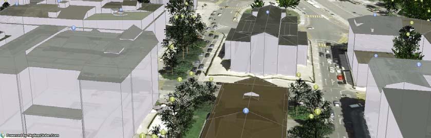
6 6


7 7


8 8
9 Thesis 2: The cadastre will blend the strategic map and the dynamic map of the land to show its historical evolution. Comment: The push of technology makes it possible to store the information with different time stamps instead of erasing or superseding it. An animation of the evolution of an object or a region becomes possible by adding the dimension of time. Spatio Temporal Object Model: Each object has an attribute of time. Consequence: The current separation between the static object and the dynamic object will be deeply transformed. A static object becomes a snapshot at a given moment of its dynamic version. Each object carries information about its history and the geographical information system integrates time as a variable. 9

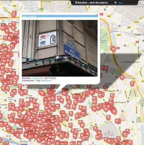
10 10
11 Thesis 3: The cadastre will be multifunctional and multijurisdictional. Comment: The political as well as the technological influence foster the emergence of functions of a territory. Different regions can be viewed not only as jurisdictions, but also through the lens of different functions such as the environmental function, the transportation function, etc. It therefore will be possible to assess the impact of policies on different functions and to create many functional approaches to the territory. Moreover, the interoperability between various local cadastres will render a change of function possible upon request. Consequence: The local cadastres will be blended into larger ones and include not only jurisdictional views but also functional views. 11

12 12


13 13
14 Thesis 4: Social networks will transform the cadastre. Comment: The phenomenon of georeference by the public becomes a more and more normal and accepted tool to extend the cadastre. Almost all new moving devices include GPS chips (smartphones, cameras, cars, even cattle!) that can report flows of data. This allows to georeference the objects and their surroundings in a completely new way. Consequence: The cadastre will deal more with flows of data and less with stocks of data. 14


15 15

16 An elephant path is a trail developed by erosion caused by people making their own shortcuts (a phenomena we love to observe). The Elephant Path application reveals unofficial routes and beaten tracks from the the thousantds of pieces of information inhabitants and visitors of a region share publicly online. It uses social navigation mechanisms that rely on the activity of groups of people to propose and suggest movements towards active places. 16
17 Thesis 5: New commons will emerge as a referenced object of the cadastre. Comment: Data will be more and more made available to the general public by the administration and, through mash-up techniques, will be transformed into a new virtual object the «Common Good». This new object is a composition of several layers of data and services. It will create value and be used as a global public good. Consequence: Both the private and the public sectors will gain added value by leveraging the these new commons. As it is mainly composed of information, the resource is essentially non-rivalrous (consumption by one person doesn t prevent simultaneous consumption by another) and non-excludable (it is difficult if not impossible to prevent someone to have access). 17


18 Entering the search term Rome on Flickr returns more than two million photographs. This collection represents an increasingly complete photographic record of the city, capturing every popular site, facade, interior, fountain, sculpture, painting, cafe, and so forth. It also offers us an unprecedented opportunity to richly capture, explore and study the three dimensional shape of the city. In this project, we consider the problem of reconstructing entire cities from images harvested from the web. Our aim is to build a parallel distributed system that downloads all the images associated with a city, say Rome, from Flickr.com. After downloading, it matches these images to find common points and uses this information to compute the three dimensional structure of the city and the pose of the cameras that captured these images. All this to be done in a day. 18
19 Thesis 6: The cadastre will become an essential element of knowledge society. Comment: The cadastre follows the same path as society as it evolves from an information society to a knowledge society. This is seen through the addition of georeference to many human activities, the emergence of co-creation by entire crowds, and the body of knowledge that the cadastre carries enters more and more into models and decisions. The objects of the cadastre will be part of a feedback loop that makes its way into knowledge society. Consequence: Land surveyors will be dealing more with soft fields of knowledge rather than hard science in the future. 19

20 Visualizing OpenStreetMap updates during OpenStreetMap is a wiki-style map of the world and this animation produces a flash of white each time a new way is entered or when an existing way is updated. Some edits are a result of a physical local survey by someone with a GPS unit, other edits will have been done remotely using aerial photography or out-of-copyright maps. Others are based on bulk imports of official or commercial datasets that are available using a suitable 'share-alike' licence. OpenStreetMap started in 2004 and the rate of contributions has been accelerating with four times as many people contributing to the project in 2008 compared to 2007 and with bulk imports of data for the Belarus, India, Italy, USA and for many other places. Supporting OpenStreetMap is an important part of ITO's business which is focused on providing high-quality on-line transport and mapping services to both organisations and individuals in the UK and around the world. 20

21 OpenStreetMap - Project Haiti With the little existing physical, political and social infrastructure now destroyed or damaged, the situation was especially challenging for aid agencies arriving on the ground. Where are the areas most in need of assistance, how do we get there, where are people trapped under buildings, which roads are blocked? This information is important to the rescue agencies immediately after the event, and to the longer rebuilding process. In many developing countries, there is a lack of good mapping data and particularly after a crisis, when up-to-date information is critical to managing events as they evolve. Enter OpenStreetMap, the wiki map of the world, CrisisMappers and an impromptu community of volunteers who collaborated to produce the most authoritative map of Haiti in existence. Within hours of the event people were adding detail to the map, but on January 14th high resolution sattelite imagery of Haiti was made freely available and the Crisis Mapping community were able to trace roads, damaged buildings, and enter camps of displaced people into OpenStreetMap. This is the story of OpenStreetMap - Project Haiti: Each flash represents a new edit into OpenStreetMap, and this visualisation is a vivid picture of how much work was contributed by volunteers, following the quake. First the primary and secondary roads (green and red) are added and then smaller residential streets and many other features such as the blue glowing camps of displaced people that emerge. 21
22 Model Transformation Dynamic Augmented Participation Analysis Personnalisation Information Transaction Data Search 22
Dimension Cadastre Stepping Beyond Limits
 Swiss Federal Directorate for Cadastral Surveying Dimension Cadastre Stepping Beyond Limits Dr. Daniel Steudler Background Think Tank active since 2012; aim is to identify the current trends in the geoinformation
A Geocoded Cadastral Fabric as a Precondition for a Sustainable Land Management System
 A Geocoded Fabric as a Precondition for a Sustainable Land Management System Gottfried KONECNY, Germany; J.P. LAUZON, Canada; Abdul Salam MOHAMMED, India Key words: SDI,, Parcel Boundaries, GPS-GNSS, Land
CADASTRE 2014: New Challenges and Direction
 CADASTRE 2014: New Challenges and Direction Anna KRELLE and Abbas RAJABIFARD, Australia Key words: Cadastre, Cadastre 2014, Land Administration SUMMARY Land and land related activities form part of the
A Vision for a Fully Digital Cadastral Survey System
 A Vision for a Fully Digital Cadastral Survey System Anselm HAANEN, Trent GULLIVER, New Zealand Key words: cadastral survey system, digital cadastre, survey plans SUMMARY Surveyors have traditionally prepared
Alternatives for Economic Boundary Determination in the Establishment of a Cadastral System. Paper to the FIG Working Week 2012 Rome, May 9, 2012
 Alternatives for Economic Boundary Determination in the Establishment of a Cadastral System Paper to the FIG Working Week 2012 Rome, May 9, 2012 by Gottfried Konecny Emeritus Professor Leibniz University
Institutional Arrangements In Geoinformation: Influence of Legal and Policy Issues **
 ADVANCE UNEDITED VERSION UNITED NATIONS E/CONF.103/24 ECONOMIC AND SOCIAL COUNCIL Tenth United Nations Regional Cartographic Conference for the Americas New York, 19-23, August 2013 Item 6 (a) of the provisional
Benchmarking Cadastral Systems Results of the Working Group 7.1
 Benchmarking Cadastral Systems Results of the Working Group 7.1 Jürg KAUFMANN, Switzerland Key words: ABSTRACT In 1998, FIG-Commission 7 launched three new working groups for the period 1998-2002. Working
Centre for SDIs and Land Administration Department of Geomatics Spatial systems to support sustainable development
 Centre for SDIs and Land Administration Department of Geomatics MODERN CADASTER and LAND ADMINISTRATION تهران-مرداد 1386 2014 ..... 2 ماه Centre for SDIs and Land Administration Department of Geomatics
Demonstrate knowledge of, and extract, cadastral data from Landonline
 Page 1 of 5 Demonstrate knowledge of, and extract, cadastral data from Landonline Level 3 Credits 5 Purpose This unit standard is for people who are working in the surveying industry in jobs which involve
Chapter 9: 3D Visualisation as a Tool to Facilitate Managing Land and Properties
 Chapter 9: 3D Visualisation as a Tool to Facilitate Managing Land and Properties Davood Shojaei Overview The rapid population growth and decrease of natural resources have concerned decision makers about
THINKING OUTSIDE THE TRIANGLE TAKING ADVANTAGE OF MODERN LAND MARKETS. Ian Williamson
 THINKING OUTSIDE THE TRIANGLE TAKING ADVANTAGE OF MODERN LAND MARKETS Ian Williamson Professor of Surveying and Land Information Head, Department of Geomatics Director, Centre for Spatial Data Infrastructures
The Strategic Plan can be viewed by clicking this link.
 What is the purpose of the Land Information Office? Many of Brown County's most basic services rely on accurate and up-to-date land information. Emergency response, resource conservation, infrastructure
A CADASTRAL GEODATA BASE FOR LAND ADMINISTRATION USING ARCGIS CADASTRAL FABRIC MODEL A CASE STUDY OF UWANI ENUGU, ENUGU STATE, NIGERIA
 A CADASTRAL GEODATA BASE FOR LAND ADMINISTRATION USING ARCGIS CADASTRAL FABRIC MODEL A CASE STUDY OF UWANI ENUGU, ENUGU STATE, NIGERIA BY Ndukwu, Raphael. Ike Department of Geoinformatics & Surveying University
LIS a motivation for SDI initiative
 Eric Mwaikambo Ardhi University Dar es Salaam Tanzania Overview Status of LIS in Tanzania Relationship between SDI and LIS Spatial Standards LIS a motivation for SDI initiative Conclusion & Recommendations
Geoinformation Technologies in Land Management and Beyond: Case of Georgia
 Geoinformation Technologies in Land Management and Beyond: Case of Georgia Joseph SALUKVADZE Professor, Department of Human Geography, Co-team Leader, Cadastre and Land Register Project, Co-financed by
Land Administration and Management Towards the Fifth Dimension
 Presented at the FIG Working Week 2016, May 2-6, 2016 in Christchurch, New Zealand Bundesamt für Landestopografie swisstopo Eidgenössische Vermessungsdirektion Land Administration and Management Towards
The Challenge to Implement International Cadastral Models Case Finland 1
 The Challenge to Implement International Cadastral Models Case Finland 1 Tarja MYLLYMÄKI and Tarja PYKÄLÄ, Finland Key words: cadastre, modelling, LADM, INSPIRE SUMMARY Efforts are currently made to develop
Advances in Modern Land Administration Cadastre 2014 in the Year 2006
 Advances in Modern Land Administration Cadastre 2014 in the Year 2006 Winfried HAWERK, Germany Key words: E-Land Administration, IT renewal strategies SUMMARY FIG Commission 7 Working Group 7.3 deals with
Opportunities for Surveyors in Modern Land Markets
 Opportunities for Surveyors in Modern Land Markets Ian WILLIAMSON, Australia Key words: Land administration, land market, cadastre SUMMARY A large component of the activities of the land surveyor, land
Revolutionizing Land Survey in the 5G era
 Presented at the FIG Working Week 2017, May 29 - June 2, 2017 in Helsinki, Finland Revolutionizing Land Survey in the 5G era Kim Muni, Republic of Korea C o n t e n t s 1 2 3 4 5 The current system of
Chapter 3: A Framework for a National Land Information Infrastructure
 Chapter 3: A Framework for a National Land Information Infrastructure Brian Marwick Overview As a federated county, Australia s land administration systems are state and territory based. These systems,
Lessons for federated countries that have state land registries the Australian experience
 Lessons for federated countries that have state land registries the Australian experience Ian Williamson Centre for SDI and Land Administration Department Infrastructure Engineering University of Melbourne
Curriculum Catalog
 2018-2019 Curriculum Catalog Career and Technical Education Series Introduction to Careers in Architecture and Construction 2018 Glynlyon, Inc. Table of Contents INTRODUCTION TO CAREERS IN ARCHITECTURE
The Contribution of Forest Owners Associations for the Forest Cadastre Implementation. João Gaspar Ana Navarro Ferreira PORTUGAL
 The Contribution of Forest Owners Associations for the Forest Cadastre Implementation João Gaspar Ana Navarro Ferreira PORTUGAL Motivation Lack of forestry cadastre; Unify all FOAs databases with common
Proposals for Best Practice
 WPLA Fees & Charges in Cadastre and Registration Proposals for Best Practice Neil King United Kingdom WPLA Fees and Charges Study Best Practice This presentation offers an overview of a draft report that
A New Vision on Cadastral Data Model
 Mohsen KALANTARI, Abbas RAJABIFARD, Jude WALLACE and Ian P. WILLIAMSON, Australia Key words: Land administration, cadastre, land parcel, legal property object, interoperability SUMMARY Land administration
Housing Ireland A Journal for Irish Housing Professionals
 www.cih.org Learn with us. Improve with us. Influence with us. Housing Ireland A Journal for Irish Housing Professionals A Chartered Institute of Housing Publication Winter 2013 Issue 03 Inside this issue:
Land Management and Development
 CLGE INTERNATIONAL CONFERENC 2005 EUROPEAN PROFESSIONAL QUALIFICATIONS IN GEODETIC SURVEYING BRUSSELS, 1-2 DECEMBER 2005 Land Management and Development Professor Stig Enemark Department of Development
From Measurement to Management
 From Measurement to Management The changing role of the land surveyors Prof. Stig Enemark Aalborg University, Denmark LAND MANAGEMENT AND HUMAN RIGHTS INTERNATIONAL SEMINAR, HØGSKOLEN I BERGEN, 8 9 SEPTEMBER
1.1.1 The Role of. the Architect
 1.1 The Architectural Profession 1.1.1 The Role of 1.1.1 the Architect Canadian Handbook of Practice for Architects 1.1.1 The Architect in Society Challenges and Opportunities for Architects in the 21st
Land Administration and Management Towards the Fifth Dimension
 Bundesamt für Landestopografie swisstopo Eidgenössische Vermessungsdirektion Land Administration and Management Towards the Fifth Dimension Geoconference on Cadastre 4.0, 25/26 Oct. 2016 Dr. Daniel Steudler
INHABITATS. architectural space-suits. paris summer school 2015 PRESENTATION ///
 INHABITATS architectural space-suits paris summer school 2015 The colonization of space is the only possible salvation of Earth. Isaac Asimov PRESENTATION /// An architectural space-suit performs several
Understanding the Land Management Paradigm
 FIG COM 7 SYMPOSIUM ON INNOVATIVE TECHNOLOGIES FOR LANDADMINISTRATION 19 25 June 2005, Madison, Wisconsin, USA. Understanding the Land Management Paradigm Prof. Stig Enemark Vice-President of FIG Department
Land Administration And Spatial Data Infrastructures
 Land Administration And Spatial Data Infrastructures Ian WILLIAMSON, Donald GRANT and Abbas RAJABIFARD Centre for SDIs and Land Administration Department of Geomatics University of Melbourne, Australia
The Cadastral Template 2.0, From Design to Implementation
 Abbas RAJABIFARD (Australia), Daniel Steudler (Switzerland), Ali AIEN, and Mohsen KALANTARI, Australia Key words: Cadastral Template 2.0, Cadastral Template Project, Land Administration, PCGIAP SUMMARY
New Technology for Cadastral Systems. Brent Jones, PE, PLS
 New Technology for Cadastral Systems Brent Jones, PE, PLS Benefits of Good Land Administration Key to addressing global challenges.. Secure Tenure Equitable Land and Property Taxation Support for Government
Modernizing Land Administration Systems
 Presented at the FIG Congress 2018, May 6-11, 2018 in Istanbul, Turkey Modernizing Land Administration Systems B r e n t J o n e s P E, PLS E s r i Land Administration Systems GIS is the Technology Platform
A FIRST ATTEMPT FOR USING VOLUNTEERED GEOGRAPHIC INFORMATION AND CROWD SOURCING TECHNIQUES IN CADASTRE
 A FIRST ATTEMPT FOR USING VOLUNTEERED GEOGRAPHIC INFORMATION AND CROWD SOURCING TECHNIQUES IN CADASTRE Sofia Basiouka National Technical University of Athens PhD student s.basiouka@gmail.com Chryssy Potsiou
LAUNCH OF CADASTRAL TEMPLATE 2.0
 LAUNCH OF CADASTRAL TEMPLATE 2.0 Dr. Daniel Steudler Scientific Associate, swisstopo Prof. Abbas Rajabifard Director Centre for SDIs and Land Administration, Melbourne University FIG-Commission 7, Annual
Preprint.
 http://www.diva-portal.org Preprint This is the submitted version of a paper presented at 10th EC GI & GIS Workshop, ESDI State of the Art, Warsaw, Poland, 23-25 June 2004. Citation for the original published
EXPLORING OPTIONS FOR STANDARDISATION OF PROCESSES AND TRANSACTIONS IN LAND ADMINISTRATION
 EXPLORING OPTIONS FOR STANDARDISATION OF PROCESSES AND TRANSACTIONS IN LAND ADMINISTRATION CHRISTIAAN LEMMEN (1),(2), EVA-MARIA UNGER (2), PETER VAN OOSTEROM (3), MOHSEN KALANTARI (4) AND KEES DE ZEEUW
Working Group 3 Application of Innovative Technology
 COMMISSION 7 Working Group 7.3 Annual Meeting Seoul, 18-23 May 2007 Working Group 3 Application of Innovative Technology Dr. Daniel Steudler Swiss Federal Directorate of Cadastral Surveying Table of Content
Field surveying inspection using tablets
 Field surveying inspection using tablets Rami Farraj, Ahmad Sghyyer Survey of Israel, Lincoln 1, Tel-Aviv, Israel rami@mapi.gov.il ahmad@mapi.gov.il Key words: Field Surveying, Cadastre, Mapping Procedures
Economic and Social Council 6 July 2018
 1 ADVANCE UNEDITED VERSION UNITED NATIONS E/C.20/2018/12/Add.1 Economic and Social Council 6 July 2018 Committee of Experts on Global Geospatial Information Management Eighth session New York, 1-3 August
The Boundary Concept Land Management Opportunities for Sustainable Development Provided by the Cadastre 2014 Approach. Jürg KAUFMANN, Switzerland
 The Boundary Concept Opportunities for Sustainable Development Provided by the Cadastre 2014 Approach Jürg KAUFMANN, Switzerland THE BOUNDARY CONCEPT AS A CHANCE FOR SURVEYORS OPPORTUNITIES CREATED BY
Standardization in the Cadastral Domain. Sub Working Group 1: Legal Aspects
 Standardization in the Cadastral Domain Sub Working Group 1: Legal Aspects Framework 10 participants 8 countries 2 sessions Updates from the different countries (mainly as to the legal aspects of cadastre)
Spatially Enabled Society Role of the Cadastre
 armasuisse Bundesamt für Landestopografie swisstopo Swiss Federal Directorate for Cadastral Surveying Spatially Enabled Society Role of the Cadastre XXIV FIG International Congress 2010 FIG-Task Force
SECTOR PUBLIC CADASTRES AND REGISTERS MARKET PARTICIPANTS
 E-SERVICES TO CITIZENS, GOVERNMENT AND BUSINESSES. LITHUANIA EXPERIENCE Arvydas Bagdonavičius State Enterprise Centre of Registers Arvydas.Bagdonavicius@registrucentras.lt REGISTERS AND IS MANAGED BY THE
Click to edit Master title style
 Click to edit Master title style Modern Cadastre and Land Administration Session 5a. The toolbox approach Jude Wallace 2007 Click to edit Overview Master title style Objectives To understand the circumstances
The South Australian Housing Trust Triennial Review to
 The South Australian Housing Trust Triennial Review 2013-14 to 2016-17 Purpose of the review The review of the South Australian Housing Trust (SAHT) reflects on the activities and performance of the SAHT
Conservancy Mission. Leveraging GIS Technologies in Chesapeake Conservation and Restoration 10/17/2018
 Leveraging GIS Technologies in Chesapeake Conservation and Restoration Rachel Soobitsky Geospatial Project Manager Chesapeake Conservancy Conservation Innovation Center Kristin Kirkwood Executive Director
IMPLEMENTATION MASTERPLAN
 ROTHERHAM TOWN CENTRE IMPLEMENTATION MASTERPLAN Prepared by WYG for Rotherham Metropolitan Borough Council June 2017 Contents Rotherham Town Centre Masterplan Introduction Town Centre Context Opportunity
From Parcel to Global Cadastre: Challenges and Issues of the Post-Reform Quebec Cadastre. Elisabetta Genovese, Francis Roy
 From Parcel to Global Cadastre: Challenges and Issues of the Post-Reform Quebec Cadastre Elisabetta Genovese, Francis Roy Department of Geomatic Sciences, Laval University, Québec, Canada elisabetta.genovese@scg.ulaval.ca
Enhancements of the Cadastral System in Switzerland
 Enhancements of the Cadastral System in Switzerland «Cadastre of Public-Law Restrictions on Landownership» and «National Utility Cadastre» Christoph Käser Content 1. Cadastre of Public-Law Restrictions
Incorporating Sustainable Development Objectives into ICT Enabled Land Administration Systems - Case Study Switzerland
 EXPERT GROUP MEETING ON INCORPORATING SUSTAINABLE DEVELOPMENT OBJECTIVES INTO ICT ENABLED LAND ADMINISTRATION SYSTEMS 9-11 November 2005, Centre for Spatial Data Infrastructures and Land Administration
Architecture (ARCH) Courses. Architecture (ARCH) 1
 Courses. Architecture (ARCH) 1") Architecture (ARCH) 1 Architecture (ARCH) Courses ARCH 5011. Graduate Representation Intensive 1. 3 Credit Hours. This course focuses on the development of visual literacy, graphic techniques, and 3D formal
Architecture (ARCH) 1 Architecture (ARCH) Courses ARCH 5011. Graduate Representation Intensive 1. 3 Credit Hours. This course focuses on the development of visual literacy, graphic techniques, and 3D formal
Utilizing 3D Building and 3D Cadastre Geometries for Better Valuation of Existing Real Estate
 Utilizing 3D Building and 3D Cadastre Geometries for Better Valuation of Existing Real Estate Umit ISIKDAG Beykent U., Turkey Mike HORHAMMER Oracle, USA Sisi ZLATANOVA, Peter VAN OOSTEROM TU Delft, The
REGISTRATION OF PROPERTIES IN STRATA
 REGISTRATION OF PROPERTIES IN STRATA REPORT ON THE WORKING SESSIONS INTRODUCTION A cadastre is usually, and in most countries, a parcel-based, and up-to-date land information system containing records
MARS Doctor User Guide Primary Care
 1 MARS Doctor User Guide Primary Care https://gp.marswales.org This guide is intended to walk you through the Appraisal Process using the online MARS system. Primarily for primary care doctors practising
Presented at the FIG Congress 2018, May 6-11, 2018 in Istanbul, Turkey
 Presented at the FIG Congress 2018, May 6-11, 2018 in Istanbul, Turkey 5 Bibliometric Analysis of Articles Presented Under Commission 7: A Case of the 25th Fig Congress in Malaysia in 2014 Zeynel Abidin
COORDINATED CADASTRES - A KEY TO BUILDING FUTURE GIS
 Proceedings of the Regional Conference on Managing Geographic Information Systems for Success, Melbourne, 3-4 July, pp.60-69 (1996). COORDINATED CADASTRES - A KEY TO BUILDING FUTURE GIS Ian P.Williamson
A Proposed Crowdsourcing Cadastral Model: Taking Advantage of Previous Experience and Innovative Techniques
 CHAPTER 30 A Proposed Crowdsourcing Cadastral Model: Taking Advantage of Previous Experience and Innovative Techniques Sofia Basiouka* and Chryssy Potsiou *National Technical University of Athens, s.basiouka@gmail.com
Aalborg Universitet. The Aalborg model of teaching in Architecture Knudstrup, Mary-Ann. Publication date: 2008
 Aalborg Universitet The Aalborg model of teaching in Architecture Knudstrup, Mary-Ann Publication date: 2008 Document Version Publisher's PDF, also known as Version of record Link to publication from Aalborg
Is there a conspicuous consumption effect in Bucharest housing market?
 Is there a conspicuous consumption effect in Bucharest housing market? Costin CIORA * Abstract: Real estate market could have significant difference between the behavior of buyers and sellers. The recent
Land Administration Infrastructures for Sustainable Development
 The Global Challenges Land Administration Infrastructures for Sustainable Development Prof. Stig Enemark Department of Development and Planning Aalborg, University, Denmark INTERNATIONAL CONFERENCE ON
Smart Infrastructure Benefits and Key Players from a Global Perspective
 Smart Infrastructure Benefits and Key Players from a Global Perspective Spatial@gov 2010 October 5-7 Canberra Jude Wallace and Abbas Rajabifard Centre for Spatial Data Infrastructures and Land Administration
Good Land Governance for the 2030 Agenda
 Good Land Governance for the 2030 Agenda Addis Ababa, Ethiopia 20-22 April, 2014 Role of Geospatial Information in Good Land Policy and Governance Oumar Sylla UN-Habitat/GLTN oumar.sylla@unhabitat.org
Use of data in Ukraine for sustainable economic growth. Oleksandr Maliuk State Service of Ukraine for Geodesy, Cartography and Cadastre
 Use of data in Ukraine for sustainable economic growth Oleksandr Maliuk State Service of Ukraine for Geodesy, Cartography and Cadastre Kehl, 2017 Content of the presentation Ukraine & StateGeoCadastre:
Re-engineering engineering the cadastre to support e-governmente
 Centre for SDIs and Land Administration Department of Geomatics Re-engineering engineering the cadastre to support e-governmente Ian Williamson UN sponsored Third Land Administration Forum, Tehran, 2009
Country Report SWITZERLAND
 armasuisse Federal Office of Topography, swisstopo Country Report SWITZERLAND Dr. Daniel Steudler Swiss Annual Meeting 2013, FIG-Commission 7 22 October 2013, Yaoundé, Cameroon Basic Dimensions SWITZERLAND
The Multipurpose Marine Cadastre A Tool for Planning & Decision Making in the Marine Environment
 The Multipurpose Marine Cadastre A Tool for Planning & Decision Making in the Marine Environment Christine Taylor Minerals Management Service (MMS) Brian Smith NOAA Coastal Services Center Maurice Hill
Complete BIM residential project
 Complete BIM residential project SARCO Architects Costa Rica Project name: Casa Magayon Type: Residential Location: Guanacaste, Costa Rica Year: 2015 Size: 13,900 ft 2 / 1290 m 2 Software used: GRAPHISOFT
THE NEED FOR APPROACHES AND TECHNOLOGY OF TOMORROW
 THE NEED FOR APPROACHES AND TECHNOLOGY OF TOMORROW KEES DE ZEEUW, CHRISTIAAN LEMMEN and BERNY KERSTEN Cadastre, Land Registry and Mapping Agency - Kadaster, The Netherlands Kees.dezeeuw@kadaster.nl Paper
State of the Johannesburg Inner City Rental Market
 State of the Johannesburg Inner City Rental Market Presentation to TUHF- 5th July 2017 5 July 2017 State of the Johannesburg Inner City Rental Market National Association of Social Housing Organisations
PROBLEMS IN REGISTRATION IN THE THIRD VERTICAL DIMENSION IN THE UNIFIED LAND REGISTRY IN HUNGARY, AND POSSIBLE SOLUTION
 3D Cadastres Technical and Legal Aspects II PROBLEMS IN REGISTRATION IN THE THIRD VERTICAL DIMENSION IN THE UNIFIED LAND REGISTRY IN HUNGARY, AND POSSIBLE SOLUTION ANDRÁS Osskó Budapest Land Office Hungary
Real Estate Transaction Method And System
 ( 1 of 1 ) United States Patent Application 20060282378 Kind Code A1 Gotfried; Bradley L. December 14, 2006 Real Estate Transaction Method And System Abstract A method and system for brokering real estate
CLGE Working for a Profession
 CLGE Working for a Profession 15. November 2017 Tallinn (ES) The public-private partnership in cadastre in Switzerland SWITZERLAND 41'290 km 2 8 million people 26 cantons ~2600 municipalities ~4.0 million
A Framework for Benchmarking Land Administration Systems
 A Framework for Benchmarking Administrati Systems Daniel Steudler and Ian P. Williams Definiti of benchmarking Benchmarking has been defined by the AusIndustry-Best Practice Program (1995) as an -going,
Introduction to ERDAS Imagine
 Course: Remote Sensing Basic Theory & Image Processing Methods 19-23 September 2011 Introduction to ERDAS Imagine Michiel Damen (damen@itc.nl) UNIVERSITY of TWENTE - Michiel Damen 1 Contents About ERDAS
GOOD SURVEY PRACTICE
 FEEDBACK VERSION 2.4 31 October 2018 GOOD SURVEY PRACTICE 1. Forward 1.1 Surveying The art and science of surveying relates to the capture of measurements, and completion of computations to determine the
The principal tasks or competencies of the General Directorate of Cadastre are:
 4th Quality Conference 1/7 1) Title of the case. Spanish e Cadastre ( Virtual Office of Cadastre, or OVC). An open space for sustainable quality in cadastral data, working with land management administrations.
GIS & GPS Applications in Valuation/Appraisal Assessments
 GIS & GPS Applications in Valuation/Appraisal Assessments Simon ADCOCK, Australia Key words: GIS, GPS, mass assessments, 3-dimensional, modelling. SUMMARY The development of GIS and GPS systems has substantially
INNOVATIVE HOUSES: CONCEPTS FOR SUSTAINABLE LIVING BY AVI FRIEDMAN
 INNOVATIVE HOUSES: CONCEPTS FOR SUSTAINABLE LIVING BY AVI FRIEDMAN DOWNLOAD EBOOK : INNOVATIVE HOUSES: CONCEPTS FOR SUSTAINABLE Click link bellow and free register to download ebook: INNOVATIVE HOUSES:
IT-SUPPORTED STATE-LAND MANAGEMENT IN A TRANSITIONAL ENVIRONMENT
 IT-SUPPORTED STATE-LAND MANAGEMENT IN A TRANSITIONAL ENVIRONMENT - Examples from Eastern Germany and Mongolia - TOPICS 1 S LAND INFORMATION SYSTEM History and main components IT-strategy and development
The Cadastre of Public-law Restrictions on Landownership in Switzerland
 The Cadastre of Public-law Restrictions on Landownership in Switzerland The new official land registry information system Maurice Barbieri, CLGE President Zagreb, 26.November 2015 Utility Cadastre Seminar
Information Quality - A Critical Success Factor How to make it all right!
 Information Quality - A Critical Success Factor How to make it all right! Anders Svensson, Sweden Key words: Cadastre, information quality, property information, property boundaries SUMMARY Sweden has
WHAT IS AN APPROPRIATE CADASTRAL SYSTEM IN AFRICA?
 WHAT IS AN APPROPRIATE CADASTRAL SYSTEM IN AFRICA? Tommy ÖSTERBERG, Sweden Key words: ABSTRACT The following discussion is based on my experiences from working with cadastral issues in some African countries
Response to Communities and Local Government Committee Inquiry into capacity in the homebuilding industry
 Response to Communities and Local Government Committee Inquiry into capacity in the homebuilding industry Page 1 of 7 1. Introduction This paper is LendInvest s response to the review by the Communities
Fit-for Purpose Approaches to Land Administration
 Fit-for Purpose Approaches to Land Administration Brent Jones, PE, PLS Global Manager, Casastre/Land Records bjones@esri.com Land Administration GIS is the platform for land administration Land administration
ARCHITECTURE (ARCH) ARCH Courses. Architecture (ARCH) 1
 ARCH Courses. Architecture (ARCH) 1") Architecture (ARCH) 1 ARCHITECTURE (ARCH) ARCH Courses ARCH 101. Survey of Architectural Education and Practice. 1 unit, W, SP Exploration of the major paradigms which have guided the development of architectural
Architecture (ARCH) 1 ARCHITECTURE (ARCH) ARCH Courses ARCH 101. Survey of Architectural Education and Practice. 1 unit, W, SP Exploration of the major paradigms which have guided the development of architectural
FGDC SUBCOMMITTEE FOR CADASTRAL DATA. October 2004 Albuquerque, New Mexico Meeting
 FGDC SUBCOMMITTEE FOR CADASTRAL DATA October 2004 Albuquerque, New Mexico Meeting The National Spatial Data Infrastructure is the means to assemble geographic information that describes the arrangements
FGDC Cadastral Data Subcommittee. December 2008
 FGDC Cadastral Data Subcommittee Annotated Bibliography: Foundational Documents for Building a Cadastral National Prepared by David Stage and Nancy von Meyer for the FGDC Cadastral Data Subcommittee Annotated
HM Treasury consultation: Investment in the UK private rented sector: CIH Consultation Response
 HM Treasury Investment in the UK private rented sector: CIH consultation response This consultation response is one of a series published by CIH. Further consultation responses to key housing developments
Supporting Capacity Development for Sustainable Land Administration Infrastructures
 THE EIGHTH UNITED NATIONS REGIONAL CARTOGRAPHIC CONFERENCE FOR THE AMARICAS (UNRCCA) 27 June 1 July 2005, United Nations Headquarters, New York Supporting Capacity Development for Sustainable Land Administration
The Proposal of Cadastral Value Determination Based on Artificial Intelligence
 The Proposal of Cadastral Value Determination Based on Artificial Intelligence Jarosław BYDŁOSZ, Piotr CICHOCIŃSKI, Piotr PARZYCH, Poland Key words: neural network, artificial intelligence, cadastral value,
Cadastre A Vision on Future Cadastral Systems
 Cadastre 2014 - A Vision on Future Cadastral Systems Jürg Kaufmann - 1 - CONTENTS ABOUT FIG ENVIRONMENT FOR THE DEVELOPMENT OF CADASTRE 2014 DEVELOPMENT OF CADASTRE 2014 PRINCIPLES OF CADASTRE 2014 EFFECTS
Presentation of CLGE
 Global and Regional Professional and Institutional Reforms, some actions of the CLGE Maurice Barbieri, CLGE President Presentation of CLGE Introduction Our Strategy Our Actions 1 Leading Surveyors Association
Cadastral Futures building a new vision for the nature and role of cadastres. XXIV FIG International Congress Sydney, April 11-15
 Cadastral Futures building a new vision for the nature and role of cadastres XXIV FIG International Congress Sydney, April 11-15 Rohan Bennett, Abbas Rajabifard, Mohsen Kalantari, Jude Wallace, Ian Williamson
FIG Commission 3 Spatial Information Management. Report of Activities 2009
 Appendix to item 10.3 Report to the 33 rd General Assembly FIG Congress in Sydney, Australia 2010 FIG Commission 3 Spatial Information Management Report of Activities 2009 1. General Since 2007, FIG Commission
Land Administration and Spatial Enablement Victoria s Experience. Chris McRae, Executive Director Land Victoria
 Land Administration and Spatial Enablement Victoria s Experience Chris McRae, Executive Director Land Victoria 4 th UN Land Administration Forum, October 2011 Outline About Land Victoria Land Victoria