The Contribution of Forest Owners Associations for the Forest Cadastre Implementation. João Gaspar Ana Navarro Ferreira PORTUGAL
|
|
|
- Alyson McDowell
- 5 years ago
- Views:
Transcription


1 The Contribution of Forest Owners Associations for the Forest Cadastre Implementation João Gaspar Ana Navarro Ferreira PORTUGAL
2 Motivation Lack of forestry cadastre; Unify all FOAs databases with common attributes and share data to the Forest National Authority and to the SiNErGIC project; Develop a freeware application to collect data for parcel characterization in the scope of the SiNErGIC project ; Replace the traditional paper form used in the field and make the process of data collecting and processing easier; Create solutions of cooperation between FOAs, private owners and Real Cadastre Entities. 2
3 Identified Problems FOAs perform forest perimeter surveys instead of parcel s delimitation; Lack of precision of some perimeter surveys; FOAs databases with different attributes that disables interoperability among FOAs; Data Protection Law demands that FOA can t share information related to private owners without permission; The FOAs demands financial compensations to share information; In the scope of the SiNErGIC project, parcels are delimited and their ownership is confirmed, however parcel contents (such as types and number of species) are not considered; Land fragmentation. 3
4 Main Goals Create a seamless database with common attributes to all the FOAs to store data to be used for parcel characterization in the scope of the SiNErGIC project; Create an application that collect the attributes of the FOAs database, increasing the data collecting rate to the FOAs database at the Office; Create partnerships and solutions among private owners, FOAs, Taxes Office and National Forest Authority to share information. 4

5 Cadastre in Portugal Portugal has two kinds of Cadastre: Geometric Rural Property Cadastre (GRPC) Real Property Cadastre (RPC) Approximately 50% of the GRPC is not updated; The urban parcels don t have real property cadastre; The North of Portugal doesn t have Real Property Cadastre and is the region with more land fragmentation; 5

6 SiNErGIC Project Formally created by the Resolution of the Council of Ministers 45/2006, May 4 th Cadastral System approved by the Decree-law 224/ 2007, May 31 st Main goals: Ensure the unique identification of parcels; Unify the existing land registry with the land registry that will be acquire; Allow a uniform information and land registry content management; Ensure compatibility among the information systems used by different entities involved in the project; Ensure that the description of the land register is supported by a graphic support; Enable the widespread use of the system by the Public Administration; Ensure access to the information by citizens and businesses. 6
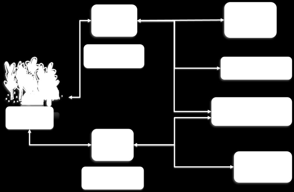
7 SiNErGIC Project Stakeholders Strategic Stakeholders Portuguese Geographic Institute (IGP) Registry and Notary Institute (IRN) Taxes General Directorate (DGCI) Local Government General Directorate (DGAL) Rules Cadastral data acquisition, management and renewal Execute and follow real property cadastre registry policy Grant regulation, control, and inspection of notary activity Manage heritage taxes Territory management agents Adapted from Julião et al. (2010) 7

8 SiNErGIC Project Infrastructure Adapted from Neto (2006) 8
 Eucalypt (Eucalyptus globulus) Cork Oak (Quercus suber); The main negative aspects of")
9 Portuguese Forests Forest covers 38.8% of the national territory; The main economics species of Portuguese forest are: Maritime Pine (Pinus pinaster) Eucalypt (Eucalyptus globulus) Cork Oak (Quercus suber); The main negative aspects of the Portuguese forest are: Land Fragmentation; Rural exodus; Owner absenteeism; Forestry policies; Forest wildfires; Lack of forest cadastre. Adapted from AFN (2010) 9
 and their profits came essentially from the services provided to the associates; FOAs contribute to the provision of several public")
10 Forest Owners Associations (FOAs) Appeared in the 90 s as an important associative initiative among forest owners, mainly in the Northern and Central regions where small scale forestry is largely predominant; The FOAs are Non-Government Organizations (NGOs) and their profits came essentially from the services provided to the associates; FOAs contribute to the provision of several public goods; Presently, there are 169 FOAs distributed in Portugal. 10
11 Forest Intervention Zones (FIZ) Approved by the Resolution of the Council of Ministers 178/ 2003, October 31 st as a measure of the Structural Reform of Forest sector; Created by the Decree-law 127/2005, August 5 th and revised by the Decree-law 15/2009, January 14 th ; A FIZ is: A continuous delimited territorial area; Formed in their majority by forest areas; Submitted to a management and wildfire protection forest plans; Managed by a single entity (Ex.: FOAs, Municipalities). 11

12 FIZs objectives: Promote an active and permanent management of forest areas; Protect the forest areas and rural areas associated in an efficient way; Promote the rehabilitation of the forest areas affected by wildfires; Reduce ignition conditions and the propagation of wildfires; Allow coordination of the different instruments that exist for land use management; Contribute to reduce land fragmentation and create conditions of economic viability for the smaller parcels. Adapted from AFN (2011) 12
13 Methods - Questionnaires To understand the kind of guidelines that FOAs follow to collect, process and store information, a questionnaire was sent to all FOAs covering the following topics: Associate Information; Parcel characterization; GPS Equipment used (Precision); Data acquisition (Real Time or Post-Processing); The kind of software used in data process (Licensed and/or Open source); Cartographic support and their scale; Data storage; The kind of compensations needed to share the information to the SiNErGIC entities. 13
14 Methods - Database Development Realize the kind of information that FOAs store to share with other entities; Harmonize all FOAs databases by creating a database with common attributes of land characterization for all FOAs and common attributes of the SiNErGIC project; This database will store attributes (alphanumeric) and geographic information; This database will promote partnerships between FOAs and the SiNErGIC entities. 14

15 Methods - Database Development 15
16 Methods - Application Development Create an application based on a freeware (CyberTracker) using the attributes compiled by the FOAs questionnaire survey and also extending to the attributes of the SiNErGIC project; Minimize the use of traditional paper forms during the field work; Increase the speed of data collection; Speed up the process of transferring data to databases of Forestry Associations; Speed up the collection of information for the Forest cadastre (SiNErGIC). 16

17 Methods - Application Development 17
18 Results and Discussion - Questionnaires In a universe of 169 FOAs only 44 were received back; From 44, one was invalid, 2 were from National FOAs and 3 from FOAs that don t use GPS; Therefore, only 38 questionnaires were considered valid: 92.7% use GPS for perimeter surveys and 7.3% use cadastral data; 36.8% collect data only with GPS, 34.2% with GPS and paper form and 28.9% use GPS with digital form; the most used GIS software is ESRI ArcGIS (81.6%); 89.5% use GPS receivers with internal antenna and 86.8% use GPS data post-processing; 63.2% were aware of planimetric and altimetric accuracies; 57.9% use aerial photos and topographic maps; In terms of land use, all FOAs delimitate forestry, 30 delimitate Agriculture, 24 delimitate community lands and only 8 FOAs consider urban delimitation; Data is stored in a computer with a GIS database by 26.3%, of the FOAs and the same amount was obtained for those that store data just in digital format in a computer. 18
19 Results and Discussion (2) - Questionnaires Ownership is proven based on the fiscal registry by 36.8% and based on the real property by 18.4% of the FOAs; The most common attributes are: date, type of stand, land use, primary specie, primary specie age, secondary specie, secondary specie age, owner s name, fiscal identification number, area, type of road, member s number, stand rotation, compass, natural values, erosion evidences among others; How FIZs are delimited: 13.2% consider only the perimeter delimitation of contiguous forest patches, 34.2% consider the perimeter delimitation of contiguous forest patches plus the parcel s type and 7.9% consider the perimeter delimitation of contiguous forest patches plus parcel s type and the exclusion of non-forest lands (however, only 55.3% of the FOAs stated that they manage one or more FIZs); All FOAs are willing to contribute to the SiNErGIC project in exchange of training courses, cartographic data and payment of the services and more than half of the FOAs (60.5%) stated that are interested in using an application to turn data acquisition easier. 19

20 Results and Discussion - Database Development 20

21 Results and Discussion - Application Development 21
22 Conclusion and Future Actions In Portugal, forest is an important sector of exportation and is urgent to create mechanisms to promote the forest management; A significant threat is the lack of long term forest management planning and the absence of cadastre for about half of the country; FOAs must be consider as a local agent of significant importance for the cadastre execution due to the closer relationship with the property owners; The conceptual data model developed in this study includes attributes that might be useful to the DGCI, for the calculation of equitable taxes, and to the IRN, for the harmonization between the real property registry and the territory s physical reality, allowing the security of tenure; The development of a unique and seamless database, to be used by all the FOAs, is a crucial factor for the establishment of the national cadastral information system. 22
23 Conclusion and Future Actions (2) To accomplish a forest cadastre, not only the attributes common to all the stakeholder s databases should be harmonized, but also the parcel s boundaries delimitation should be performed in agreement with the SiNErGIC technical specifications; The freeware application, developed to be used by the FOA s technicians when performing the cadastral surveys, has the capability of allowing the simultaneous acquisition of graphic and alphanumeric data. In such manner, those parcels can be included and/or updated in the real property cadastre; The compensations to FOAs to share information might be training courses on the SiNErGIC technical specifications, base cartography to support the parcel s delimitation and/or financial support; It is relevant to define the data policy specifying the basic principles to be observed by individuals and institutions when generating, collecting, transforming, disseminating, and making use of data. 23

24 Thank you for your time. 24
Reliability of the Italian cadastral system data quality and improvement prospects
 Reliability of the Italian cadastral system data quality and improvement prospects Eng. Franco MAGGIO (Central Director for Cadastral, Cartographic and Land Registration Services) Eng. Arturo ANGELINI
ABSTRACT Land Administration System in Lithuania
 ABSTRACT Land Administration System in Lithuania 1. General introduction to the Lithuanian Land Administration System and State Enterprise Centre of Registers ( shortly SECR) Lithuania has established
REFORM OF LAND CADASTRE IN LITHUANIA
 REFORM OF LAND CADASTRE IN LITHUANIA Romualdas KASPERAVICIUS, Lithuania Key words: ABSTRACT Main aim for every Government is to create legal, financial and organisational circumstances for real property.
Ownership Data in Cadastral Information System of Sofia (CIS Sofia) from the Available Cadastral Map
 from the Available Cadastral Map") Ownership Data in Cadastral Information System of Sofia (CIS Sofia) from the Available Cadastral Map Key words: ABSTRACT Lydmila LAZAROVA, Bulgaria CIS Sofia is created and maintained by GIS Sofia ltd,
Ownership Data in Cadastral Information System of Sofia (CIS Sofia) from the Available Cadastral Map Key words: ABSTRACT Lydmila LAZAROVA, Bulgaria CIS Sofia is created and maintained by GIS Sofia ltd,
BULGARIAN CADASTRE A GUARANTEE FOR THE OWNERSHIP RIGHTS IN IMMOVABLE PROPERTIES
 4 TH INTERNATIONAL CONFERENCE RECENT PROBLEMS IN GEODESY AND RELATED FIELDS WITH INTERNATIONAL IMPORTANCE February 28 - March 2, 2007, Inter Expo Centre, Sofia, Bulgaria BULGARIAN CADASTRE A GUARANTEE
Improving Land Governance in River Senegal Valley Context, Issues and Challenges
 Improving Governance in River Senegal Valley Context, Issues and Challenges Key words: Decentralized Management, Senegal, Cadastre, Registration SUMMARY After presenting economic social and demographic
Spatial Data Infrastructure in Sweden
 Spatial Data Infrastructure in Sweden Hans-Erik WIBERG, Sweden Key words: ABSTRACT Sweden was one of the first countries to address Data Infrastructure matters and have during several decades developed
PAPER ON THE MANAGEMENT OF SUSTAINABLE DELIVERY OF SECURED PROPERTY RIGHTS THROUGH EMPOWERNMENT AND CAPACITY BUILDING OF LOCAL GOVERNMENT AUTHORITIES
 PAPER ON THE MANAGEMENT OF SUSTAINABLE DELIVERY OF SECURED PROPERTY RIGHTS THROUGH EMPOWERNMENT AND CAPACITY BUILDING OF LOCAL GOVERNMENT AUTHORITIES PRESENTED AT: THE UNITED NATIONS AWARD PROGRAM HELD
PROJECT INFORMATION DOCUMENT (PID) APPRAISAL STAGE Report No.: PIDA Project Name. Region Country Sector(s) Theme(s)
 APPRAISAL STAGE Report No.: PIDA Project Name. Region Country Sector(s) Theme(s)") Public Disclosure Authorized Public Disclosure Authorized Public Disclosure Authorized Public Disclosure Authorized Project Name Region Country Sector(s) Theme(s) Lending Instrument Project ID Borrower(s)
Public Disclosure Authorized Public Disclosure Authorized Public Disclosure Authorized Public Disclosure Authorized Project Name Region Country Sector(s) Theme(s) Lending Instrument Project ID Borrower(s)
Amalia Velasco Carlos Alonso Luis Virgos Fernando Serrano
 Inspire services of the Spanish Directorate General for Cadastre and its use to resolve an old problem of coordination between Spanish Cadastre and Land Registry. Amalia Velasco Carlos Alonso Luis Virgos
Egyptian Nationwide Title Cadastre System
 Kholoud SAAD, Egypt Key words: Cadastre, Registration, Urban, Rural, National Cadastre, Automation, reengineering. SUMMARY With growing need for integrated information, Enterprise Solutions has become
A Geocoded Cadastral Fabric as a Precondition for a Sustainable Land Management System
 A Geocoded Fabric as a Precondition for a Sustainable Land Management System Gottfried KONECNY, Germany; J.P. LAUZON, Canada; Abdul Salam MOHAMMED, India Key words: SDI,, Parcel Boundaries, GPS-GNSS, Land
Aspect of preliminary activities in the function of supporting NSDI
 Sonja DIMOVA, Republic of Macedonia Key words: e-governance, geospatial data, NSDI, INSPIRE, metadata SUMMARY The successful establishment of the NSDI in the true sense of the word cannot be performed
Cadastral Template 2003
 PCGIAP-Working Group 3 "Cadastre" FIG-Commission 7 "Cadastre and Land Management" Cadastral Template 2003 The establishment of a cadastral template is one of the objectives of Working Group 3 "Cadastre"
Test and Implementation of DATR System in Hungary
 Test and Implementation of DATR System in Hungary, Hungary Key words: unified land registry, cadastral map, Hungary SUMMARY During the last years there has been an important development in the Hungarian
A Complete, Free Solution for Cadastral Map Management
 A Complete, Free Solution for Cadastral Map Management Gyula IVÁN Institute of Geodesy, Cartography & Remote Sensing (FÖMI) HUNGARY FIG Commission 7, Annual Meeting 11-15 September 2008., Verona, ITALY
Reporting Thailand Cadastral System in Cadastre 2014 Trends BY VUTTINAN UTESNAN. Rajamangala University of Technology Krungthep
 Reporting Thailand Cadastral System in Cadastre 2014 Trends BY VUTTINAN UTESNAN Rajamangala University of Technology Krungthep Faculty of Engineering, Bangkok, THAILAND Topics INTRODUCTION THAILAND CADASTRAL
Cadastral data, a case of role repositioning. Alberto Donis
 IL SISTEMA INFORMATIVO CATASTALE: UNA RISORSA PER LE POLITICHE DI GOVERNO DEL TERRITORIO II Sessione Il ruolo dell informazione catastale nel governo del territorio Cadastral data, a case of role repositioning
THE TURKS & CAICOS ISLANDS
 THE TURKS & CAICOS ISLANDS CROWN LAND POLICY Empowering our people, building our nation The Ministry of Natural Resources Government Compound Grand Turk Tel: 946-2801 PREAMBLE The crown is the largest
PROJECT INFORMATION DOCUMENT (PID) CONCEPT STAGE Report No.: AB3229 Project Name. Land Registry and Cadastre Modernization Project Region
 CONCEPT STAGE Report No.: AB3229 Project Name. Land Registry and Cadastre Modernization Project Region") PROJECT INFORMATION DOCUMENT (PID) CONCEPT STAGE Report No.: AB3229 Project Name Land Registry and Cadastre Modernization Project Region EUROPE AND CENTRAL ASIA Sector Central government administration
PROJECT INFORMATION DOCUMENT (PID) CONCEPT STAGE Report No.: AB3229 Project Name Land Registry and Cadastre Modernization Project Region EUROPE AND CENTRAL ASIA Sector Central government administration
Land Cadastre Act. Chapter 1. Passed RT I 1994, 74, 1324 Entry into force (except 3 which entered into force on 1.01.
 Issuer: Riigikogu Type: act In force from: 01.01.2011 In force until: 31.12.2014 Translation published: 24.10.2014 Passed 12.10.1994 RT I 1994, 74, 1324 Entry into force 08.11.1994 (except 3 which entered
The principal tasks or competencies of the General Directorate of Cadastre are:
 4th Quality Conference 1/7 1) Title of the case. Spanish e Cadastre ( Virtual Office of Cadastre, or OVC). An open space for sustainable quality in cadastral data, working with land management administrations.
Designing for transparency and participation in the Hellenic Cadastral Project
 Designing for transparency and participation in the Hellenic Cadastral Project Dr. Dimitris Rokos Director of Planning and Investments, Hellenic National Cadastre and Mapping Agency S.A. Table of Contents
Functional system for cadastral plans
 , Republic of Macedonia Key words: Cadastre, Digital plans, Data, System SUMMARY The analysis shows that the real estate market in Republic of Macedonia grows daily. With the expansion of this market increases
A CADASTRAL GEODATA BASE FOR LAND ADMINISTRATION USING ARCGIS CADASTRAL FABRIC MODEL A CASE STUDY OF UWANI ENUGU, ENUGU STATE, NIGERIA
 A CADASTRAL GEODATA BASE FOR LAND ADMINISTRATION USING ARCGIS CADASTRAL FABRIC MODEL A CASE STUDY OF UWANI ENUGU, ENUGU STATE, NIGERIA BY Ndukwu, Raphael. Ike Department of Geoinformatics & Surveying University
Theme II. Customers and Services NEW PROJECTS OF THE AGENZIA DEL TERRITORIO. Marco SELLERIE
 UNITED NATIONS ECONOMIC COMMISSION FOR EUROPE COMMITTEE ON HUMAN SETTLEMENTS WORKING PARTY ON LAND ADMINISTRATION Workshop "Customer - Co-operation - Services" Vienna, Austria 12-13 September 2002 Theme
Utility networks in Estonian Restrictions Information
 Utility networks in Estonian Restrictions Information System Mr. Priit Kuus Department of Land Cadastre priit.kuus@maaamet.ee +372 675 0843 Tallinn 2011 Restrictions: legal grounds The Constitution of
Presented by: Stewart Information International, Inc. Jack McKenna
 Presented by: Stewart Information International, Inc. Jack McKenna Held at the: 2007 ESRI Survey & Engineering GIS Summit San Diego Convention Center San Diego, California June 16-19, 2007 Integrating
Annual Meeting 2006 SLOVENIA, BLED RASAS GOFMANAS JAUNIUS GRIGAS RIMANTAS RAMANAUSKAS KESTUTIS TRECIOKAS
 Annual Meeting 2006 SLOVENIA, BLED LAND ADMINISTRATION IN LITHUANIA RASAS GOFMANAS JAUNIUS GRIGAS RIMANTAS RAMANAUSKAS KESTUTIS TRECIOKAS ADMINISTRATIVE STRUCTURE OF LITHUANIA HISTORY OF LAND ADMINISTRATION
PROPOSAL FOR THE URBAN REAL ESTATE PROPERTY TAX MANAGEMENT DIAGNOSIS IN BRAZIL
 PROPOSAL FOR THE URBAN REAL ESTATE PROPERTY TAX MANAGEMENT DIAGNOSIS IN BRAZIL Marcos A. PELEGRINA and Lia BASTOS Maio de 2009 Geog. Marcos A.. Pelegrina, M.Engº 1 Geog. Marcos A.. Pelegrina, M.Engº 2
Quality Improvement of the Real Estate Cadastre in Serbia
 , Serbia Key words: quality improvement, real estate information, quality assurance, Serbia SUMMARY The concept of cadastral modernization in the Republic of Serbia was defined in 1992, and it is being
Upgrading and Land Titling in Informal Settlements. Manica City
 Expert Group Meeting on secure land tenure: 'new legal frameworks and tools' November10-12 2004, UNGigiri in Nairobi, Kenya Upgrading and Land Titling in Informal Settlements Manica City MANICA PROVINCE,
Preprint.
 http://www.diva-portal.org Preprint This is the submitted version of a paper presented at 10th EC GI & GIS Workshop, ESDI State of the Art, Warsaw, Poland, 23-25 June 2004. Citation for the original published
(UNECE) John Manthorpel
 John Manthorpel") Lanc Registration and Land Valuation in the United Kingdom and in the countries of the United Nations Economic Commission for Europe (UNECE) John Manthorpel Introduction This paper is in two parts and
Lanc Registration and Land Valuation in the United Kingdom and in the countries of the United Nations Economic Commission for Europe (UNECE) John Manthorpel Introduction This paper is in two parts and
Cadastral Map Upgrading and Layers Harmonization for the Spatial Data Infrastructure in Friuli Venezia Giulia, Italy
 Cadastral Map Upgrading and Layers Harmonization for the Spatial Data Infrastructure in Friuli Venezia Giulia, Italy A. Beinat, F. Crosilla, E. Sossai M. Basso, R. Piuzzo 2 Summary - The cadastral mapping:
International Workshop Land Banking/Land Funds as an Instrument for Improved Land Management for CEEC and CIS March 2004 Tonder,, Denmark
 MINISTRY OF AGRICULTURE AND FORESTRY SOFIA, BULGARIA International Workshop Land Banking/Land Funds as an Instrument for Improved Land Management for CEEC and CIS 17-20 March 2004 Tonder,, Denmark BULGARIAN
Object Oriented Unified Real Estate Registry for a Good Spatial Data Management
 Object Oriented Unified Real Estate Registry for a Good Spatial Data Management Gyula IVÁN Gábor SZABÓ Zoltán WENINGER Institute of Geodesy, Cartography and Remote Sensing (FÖMI), Hungary Workshop on e-governance,
Challenges for the multi purpose cadastre
 Jens RIECKEN, Markus SEIFERT, Germany Key words: Multi purpose cadastre, 3d-cadastre, land use, SDI, solar cadastre SUMMARY Over the past 30 years, with the progress of information technologies the development
INTRODUCTION - Land is the platform of all societies activities. - Land policy regulates the access to land and the management of land.
 INTRODUCTION - Land is the platform of all societies activities. - Land policy regulates the access to land and the management of land. - An acceptable and proactive land policy is a critical success factor
The Private Surveyor Privileged Partner of the Belgian Cadastre
 The Private Surveyor Privileged Partner of the Belgian Cadastre Francis GABELE and Marc VANDERSCHUEREN, Belgium Key words: Private surveyor, Professional code of ethics, Public Officer, Partner, Preliminary
LADM-based Crowdsourced 3D Cadastral Surveying Potential and Perspectives
 National Technical University Of Athens School of Rural and Surveying Engineering LADM-based Crowdsourced 3D Cadastral Surveying Potential and Perspectives Maria Gkeli, Surveying Engineer, PhD student
Regional Cadastral Study Reforms in the Region
 UNECE WORKING PARTY ON LAND ADMINISTRATION Workshop on the Influence of Land Administration on People and Business Cavtat, Croatia 2-3 October 2008 Regional Cadastral Study Reforms in the Region Miodrag
Ordinance on Official Cadastral Surveying
 English is not an official language of the Swiss Confederation. This translation is provided for information purposes only and has no legal force. Ordinance on Official Cadastral Surveying 211.432.2 of
D DAVID PUBLISHING. Mass Valuation and the Implementation Necessity of GIS (Geographic Information System) in Albania
 in Albania") Journal of Civil Engineering and Architecture 9 (2015) 1506-1512 doi: 10.17265/1934-7359/2015.12.012 D DAVID PUBLISHING Mass Valuation and the Implementation Necessity of GIS (Geographic Elfrida Shehu
Journal of Civil Engineering and Architecture 9 (2015) 1506-1512 doi: 10.17265/1934-7359/2015.12.012 D DAVID PUBLISHING Mass Valuation and the Implementation Necessity of GIS (Geographic Elfrida Shehu
Land Administration Developments in Rwanda
 Land Administration Developments in Rwanda Eugène RURANGWA Expert Group Meeting on secure land tenure new legal frameworks and tools UN-Gigiri, Nairobi, 10-12 November, 2004 Contents Somme figures about
AREC responsibilities, data and registries and the way of their distribution
 Data as a basis of the digital society PCC, 13-15 March 2018, Sofia AREC responsibilities, data and registries and the way of their distribution Vlatko Dimovski Agency for Real Estate Cadastre (AREC) the
Slovenian Experiences
 Slovenian Experiences An example from a transition country Milan Brajnik, B.Sc.Geod., Assistant Director milan.brajnik@geod-is.si Geodetic Institute of Slovenia 1000 Ljubljana, Jamova cesta 2 The Identity
The Development Strategy for Cadastre and Land Register in Finland
 1 2 The Development Strategy for and Land in Finland Arvo Kokkonen Ministry of Agriculture and Forestry Facts and figures of Finland - land area 304 530 km² - water area 33 615 km² - total area 338 195
Cadastral Framework Standards
 Cadastral Framework Standards The goal of the Data Standards and Recommendations Committee is to provide recommendations and guidelines to Indiana GIS user communities to facilitate the collection, maintenance
Building Integrated Land Information Systems and Development of NSDI
 Stig JÖNSSON, Sweden Key words: Land administration, land information systems, property formation, spatial data infrastructure, Inspire, institutional cooperation SUMMARY Lantmäteriet the Swedish agency
Cadastre: definitions
 Introduction New vision towards a multipurpose cadastral system to support land management in Morocco Moha EL-AYACHI, El Hassane SEMLALI, Mohamed ETTARID, Driss TAHIRI, Institut Agronomique et Vétérinaire
Cadastral Information System of Sofia
 Alexander LAZAROV and Hristo DECHEV, Bulgaria Key words: ABSTRACT A new Cadastre and Property Register Act (CPRA) was passed in April 2000, setting up rules for the maintenance of these two registers.
Hungarian Cadastre and its relation to LADM
 Hungarian Cadastre and its relation to LADM Gyula IVÁN CLGE General Assembly 22 March 2013, Budapest, HUNGARY Content Historical background Evolution of Cadastral modeling in Hungary LADM issues Conclusion
LRIMS Cadastre Module
 LRIMS Cadastre Module User Requirements and Functionality (Seychelles Case Study) John Latham, NRL Renato Cumani, NRL Luigi Simeone, NRL Summary Background User Requirements Business Model Application
Geoinformation Technologies in Land Management and Beyond: Case of Georgia
 Geoinformation Technologies in Land Management and Beyond: Case of Georgia Joseph SALUKVADZE Professor, Department of Human Geography, Co-team Leader, Cadastre and Land Register Project, Co-financed by
GOVERNMENT. Case Study Ville de Trois Rivières streamlines property assessment
 GOVERNMENT Case Study Ville de Trois Rivières streamlines property assessment GIS-generated parcel basemap provides powerful visualization & analysis capabilities With a population of just over 130,000,
TERMS OF REFERENCE FOR CONSULTANCY SERVICES TO PREPARE PROJECT DOCUMENT FOR CADASTRAL MAPPING IN THE GAMBIA
 Ministry of Lands and Regional Government United Nations Development Program UNDP April 2017 TERMS OF REFERENCE FOR CONSULTANCY SERVICES TO PREPARE PROJECT DOCUMENT FOR CADASTRAL MAPPING IN THE GAMBIA
CADASTRAL WORKS in TURKEY AND GDLRC (TKGM)
") CADASTRAL WORKS in TURKEY AND GDLRC (TKGM) NOVEMBER 2011 SOME NUMBERS ABOUT TURKEY Area :783.600 Km 2 Population : 747 millions (2008) Number of land parcels : 555 millions Villages and quarters : 52.437
CADASTRAL WORKS in TURKEY AND GDLRC (TKGM) NOVEMBER 2011 SOME NUMBERS ABOUT TURKEY Area :783.600 Km 2 Population : 747 millions (2008) Number of land parcels : 555 millions Villages and quarters : 52.437
Integration of Public Service Procedures and Use of Cadastral Data
 Integration of Public Service Procedures and Use of Cadastral Data Signe Rudzite Head of Cadastre and Register Department The State Land Service Vilnius, 21.10.2013 Content General information Current
NATIONAL LAND POLICY ON AGRICULTURE DEVELOPMENT
 NATIONAL LAND POLICY ON AGRICULTURE DEVELOPMENT Prepared by: J.M.Kami Director of Land Use Coordination and Policy Presented by: NATIONAL LAND USE PLANNING COMMISSION Towards a New National Land Policy
Quality Improvement to Cadastral Information in Sweden
 Gunnar BLIXT, Sweden Key words: digital cadastre, quality, cadastral index map, real property register. SUMMARY Lantmäteriet is a governmental agency which gives support for creating an efficient and sustainable
Information System of Electronic Cadastre Registration of Lands in Azerbaijan
 The State Committee on Property Issues of the Republic of Azerbaijan Information System of Electronic Cadastre Registration of Lands in Azerbaijan Chıngız Tanırverdiyev-chief engineer Cadastre and Land
Report No.: ISDSA15389
 Public Disclosure Authorized Public Disclosure Authorized Public Disclosure Authorized Public Disclosure Authorized 0 o Date ISDS Prepared/Updated: 12-ct-2015 INTEGRATED SAFEGUARDS DATA SHEET APPRAISAL
Incorporating Sustainable Development Objectives into ICT Enabled Land Administration Systems - Case Study Switzerland
 EXPERT GROUP MEETING ON INCORPORATING SUSTAINABLE DEVELOPMENT OBJECTIVES INTO ICT ENABLED LAND ADMINISTRATION SYSTEMS 9-11 November 2005, Centre for Spatial Data Infrastructures and Land Administration
Topographic Signs Important Context of 3D Cadastre
 STATE GEODETIC ADMINISTRATION Gruška 20,10 000 Zagreb, Croatia Delft University of Technology Faculty of Architecture and the Built Environment Department OTB GIS Technology Section Topographic Signs Important
Analyses of the Results of Land Consolidation Studies by GIS
 Analyses of the Results of Land Consolidation Studies by GIS Fatih ISCAN, Turkey Key words: Land consolidation, GIS, landholding, planning, spatial analyse SUMMARY Rural development generally refers to
Ministry of Mines, Industry and SME
 Republic of Senegal Ministry of Mines, Industry and SME User Conference 2010 08/02/2010 COPYRIGHT 2010. SPATIAL DIMENSION (PTY) LTD. A MINING CADASTRE IN SENEGAL: IMPLEMENTATION PROCESS AND ORGANIZATIONAL
The cadastre of buildings' energy performance - The Case Study of the Regione Lombardia
 The cadastre of buildings' energy performance - The Case Study of the Regione Lombardia Massimiliano ROMAGNOLI, Italy Key words: Energy, Environment, Law, Building. SUMMARY As part of a series of national
Unified Land Administration for a Better Spatial Infrastructure
 Unified Land Administration for a Better Spatial Infrastructure Gyula IVÁN Institute of Geodesy, Cartography & Remote Sensing FÖMI (HUNGARY) Open Symposium 30th Korean Cadastral Seminar & FIG Commission
The Use of Cadastral Information in Projects Financed by the EU: The Hellenic Cadastre
 The Use of Cadastral Information in Projects Financed by the EU: The Hellenic Cadastre Prof. D. Balodimos Vice-President of Ktimatologio S.A. (Hellenic Cadastre) Acknowledgements Dr. Panos Lolonis, Coordinator
LADM in the Republic of Croatia making and testing country profile
 STATE GEODETIC ADMINISTRATION Gruška 20,10 000 Zagreb, Croatia LADM in the Republic of Croatia making and testing country profile Nikola Vučić Danko Markovinović Blaženka Mičević CONTENTS INTRODUCTION
Legal Analysis of Memorandum of Understanding between the Government of Timor Leste and GTLeste Biotech. Legal issues concerning land and evictions
 Legal Analysis of Memorandum of Understanding between the Government of Timor Leste and GTLeste Biotech Legal issues concerning land and evictions A Memorandum of Understanding (MOU) was signed between
Development of Cadastral Survey and Land Ownership Registration System in Mongolia
 Development of Cadastral Survey and Land Ownership Registration System in Mongolia M.Saandar,, Ph. D Vice President, the Mongolian Association of Surveying and Mapping, ( As National Member of FIG ) MonMap
Experiences with land consolidation and land banking in Slovenia since 1991
 Experiences with land consolidation and land banking in Slovenia since 1991 Anka LISEC University of Ljubljana Faculty of Civil and Geodetic Engineering anka.lisec@fgg.uni-lj.si University of Ljubljana
Commission 7, Land Administration and IT. Paul van der Molen INTERNATIONAL INSTITUTE FOR GEO-INFORMATION SCIENCE AND EARTH OBSERVATION
 Commission 7, Land Administration and IT Paul van der Molen INTERNATIONAL INSTITUTE FOR GEO-INFORMATION SCIENCE AND EARTH OBSERVATION FIG Commission 7 on cadastre and land management Study Visits (e.g.
National Spatial Data Infrastructure development in Republic of Macedonia
 National Spatial Data Infrastructure development in Republic of Macedonia Sonja Dimova, state advisor for geomatics AGENCY FOR REAL ESTATE CADASTRE September 6-th, 2017, Strasbourg AREC competence for
Land consolidation and rural development in Serbia
 1 Land consolidation and rural development in Serbia Stevan Marosan University of Belgrade, Faculty of Civil Engineering, Department for Geodesy and Geoinformatics Maja Trajkovic Ministry of Finance Vladan
ASSESSMENT OF CONSEQUENCES RESULTING FROM ABOLISHING THE OBSTACLES ON LAND TRANSACTIONS 1 SUMMARY
 ASSESSMENT OF CONSEQUENCES RESULTING FROM ABOLISHING THE OBSTACLES ON LAND TRANSACTIONS 1 SUMMARY I. Foreign practice in regulation of land market and the EU legal provisions Having analysed the existing
Use of data in Ukraine for sustainable economic growth. Oleksandr Maliuk State Service of Ukraine for Geodesy, Cartography and Cadastre
 Use of data in Ukraine for sustainable economic growth Oleksandr Maliuk State Service of Ukraine for Geodesy, Cartography and Cadastre Kehl, 2017 Content of the presentation Ukraine & StateGeoCadastre:
Importance of a real estate cadastre as the basic, reference public register in the sustainable country development
 Importance of a real estate cadastre as the basic, reference public register in the sustainable country development Ludmiła PIETRZAK, POLAND Key words: cadastre, land and buildings register, public register,
Progress Report on Green Paper. Dr. Paddy Prendergast. on behalf of the. IIS Commission on Land Registration
 Progress Report on Green Paper By Dr. Paddy Prendergast on behalf of the IIS Commission on Land Registration Paddy Prendergast - Chair Brendan Sweeny - Hempenstall Surveys Paul Corrigan - P Corrigan Associates
New Developments in the Hellenic Cadastre
 New Developments in the Hellenic Cadastre Prof. M. Kavouras Vice-president Ktimatologio S.A. (Hellenic Cadastre) The Hellenic Cadastre Background The Hellenic National Cadastre Organizational and institutional
The Survey Data Model Technology A practical survey solution to generate all levels of spatial and e-governance outcomes.
 Land Governance in a Rapidly Changing Environment Annual World Bank Conference on Land and Poverty April 24 & 25, 2012 The Survey Data Model Technology A practical survey solution to generate all levels
The Challenge to Implement International Cadastral Models Case Finland 1
 The Challenge to Implement International Cadastral Models Case Finland 1 Tarja MYLLYMÄKI and Tarja PYKÄLÄ, Finland Key words: cadastre, modelling, LADM, INSPIRE SUMMARY Efforts are currently made to develop
TCP PROJECT AGREEMENT SUPPORT GOVERNMENT IN FORMULATION OF A NATIONAL AND GENDER SENSITIVE LAND POLICY GUIDED BY THE VGGT PRINCIPLES
 TCP PROJECT AGREEMENT SUPPORT GOVERNMENT IN FORMULATION OF A NATIONAL AND GENDER SENSITIVE LAND POLICY GUIDED BY THE VGGT PRINCIPLES THE PROBLEM Insecure tenure rights Property rights contestation Poor
Participants of the Ministerial Meeting on Housing and Land Management on 8 October 2013 in Geneva
 Summary At its meeting on 2 April 2012, the Bureau of the Committee on Housing and Land Management of the United Nations Economic Commission for Europe agreed on the need for a Strategy for Sustainable
GAUSSCAD A WEBGIS APPLICATION FOR COLLECTING CADASTRAL DATA
 M.M. Moise GaussCAD a WebGIS Application for Collecting Cadastral Data GAUSSCAD A WEBGIS APPLICATION FOR COLLECTING CADASTRAL DATA Mihai-Mircea MOISE, S.C. GAUSS S.R.L., mihai.moise@gauss.ro Abstract:
REGISTRATION OF PROPERTIES IN STRATA
 REGISTRATION OF PROPERTIES IN STRATA REPORT ON THE WORKING SESSIONS INTRODUCTION A cadastre is usually, and in most countries, a parcel-based, and up-to-date land information system containing records
Establishing a Land policy reform and GPS Technology implementation in Burkina Faso
 Annual World Bank Conference on Land and Poverty 2013 Establishing a Land policy reform and GPS Technology implementation in Burkina Faso Presentation made by Moha EL-AYACHI, IAV Hassan 2, Morocco Paper
COMPUTERIZED SYSTEM SUPPORTING DEVELOPMENT OF LAND MARKET IN GEORGIA
 COMPUTERIZED SYSTEM SUPPORTING DEVELOPMENT OF LAND MARKET IN GEORGIA S. G. TSIRAMUA, I. S. MELASHVILI Land Registration Unit of Government of Georgian, World Bank and IFAD Agriculture Development Project.
Parcel Boundaries in the Czech Republic
 Parcel Boundaries in the Czech Republic CZECH REPUBLIC Jiri Rydval, Libor Tomandl Czech Office for Surveying, Mapping and Cadastre inhabitants - 10.3 million territory 78,865 km 2 2 Contents: 1. A parcel
Land Information System as new instrument for Land Administration: Case Examples. Mike Cheremshynskyi Consultant, Land Administration Expert
 Land Information System as new instrument for Land Administration: Case Examples Mike Cheremshynskyi Consultant, Land Administration Expert Background Growth of population and fast urbanization in many
LAW OF MONGOLIA ON MINERALS (REVISED) July 8, CHAPTER ONE General provisions
 July 8, CHAPTER ONE General provisions") LAW OF MONGOLIA ON MINERALS (REVISED) State Palace. Ulaanbaatar city July 8, 2006 CHAPTER ONE General provisions Article 1. Purpose of the Law 1.1. The purpose of this Law is to regulate the relations
LAW OF MONGOLIA ON MINERALS (REVISED) State Palace. Ulaanbaatar city July 8, 2006 CHAPTER ONE General provisions Article 1. Purpose of the Law 1.1. The purpose of this Law is to regulate the relations
Fiscal Cadastral Reform and the Implementation of CAMA in Cape Town: financing transformation
 Fiscal Cadastral Reform and the Implementation of CAMA in Cape Town: financing transformation Jennifer WHITTAL, South Africa Mike BARRY, Canada Policies and Innovations Expert Group Meeting on Secure Land
HOUSING AND PROPERTY MARKET IN LITHUANIA CONTENTS
 HOUSING AND PROPERTY MARKET IN LITHUANIA Kęstutis Sabaliauskas, Director General State Enterprise Centre of Registers, Lithuania Kestutis.Sabaliauskas@registrucentras.lt CONTENTS Legal environment Real
The New Technology of a Survey Data Model and Cadastral Fabric as the Foundation for a Future Land Administration System.
 The New Technology of a Survey Data Model and Cadastral Fabric as the Foundation for a Future Land Ian HARPER, Australia Key words: cadastral modelling, survey data model, Survey Accuracy, Cadastre 2014
SECTOR PUBLIC CADASTRES AND REGISTERS MARKET PARTICIPANTS
 E-SERVICES TO CITIZENS, GOVERNMENT AND BUSINESSES. LITHUANIA EXPERIENCE Arvydas Bagdonavičius State Enterprise Centre of Registers Arvydas.Bagdonavicius@registrucentras.lt REGISTERS AND IS MANAGED BY THE
Establishment of a land market in Ukraine: current state and prospects
 Establishment of a land market in Ukraine: current state and prospects More than 25 years have passed since the adoption of the first resolution of the Verkhovna Rada On Land Reform. Despite such a long
FIG-WB Forum on Land Administration and reform in Sub-Sahara Africa
 FIG-WB Forum on Land Administration and reform in Sub-Sahara Africa Chris Mnyanga Ministry of Lands UNITED REPUBLIC OF TANZANIA] FIG WORKING WEEK, Abuja, NIGERIA 2013-6-10 MAY 2013 Country at Glance UNITED
CATALOGING, MONITORING AND MANAGING INVASIVE SPECIES ON POST LANDS. PSU Geog596A Capstone Proposal Dale Jantzen Dec 17, 2015
 CATALOGING, MONITORING AND MANAGING INVASIVE SPECIES ON POST LANDS PSU Geog596A Capstone Proposal Dale Jantzen Dec 17, 2015 PROJECT OUTLINE AND PURPOSE Define a particular need within a non-profit land