Conservancy Mission. Leveraging GIS Technologies in Chesapeake Conservation and Restoration 10/17/2018
|
|
|
- Caren Powers
- 5 years ago
- Views:
Transcription


1 Leveraging GIS Technologies in Chesapeake Conservation and Restoration Rachel Soobitsky Geospatial Project Manager Chesapeake Conservancy Conservation Innovation Center Kristin Kirkwood Executive Director Harford Land Trust Hali Plourde Rogers Executive Director Virginia Eastern Shore Land Trust Jon Chapman Stewardship Manager Maryland Environmental Trust Conservancy Mission 1


2 10/17/2018 Getting the right practices, in the right places, at the right scale, and making sure they are working Previously Available Data 2
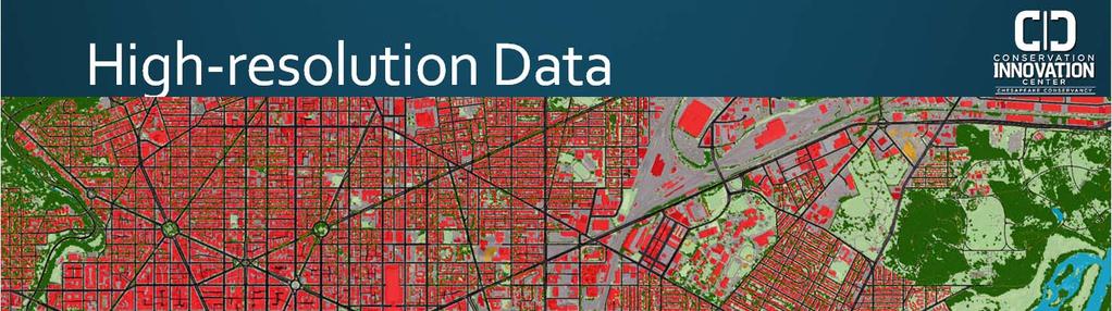
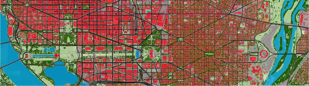
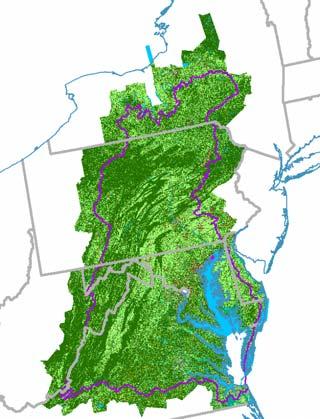
3 High resolution Data High resolution Data Planning at the Parcel Scale 3

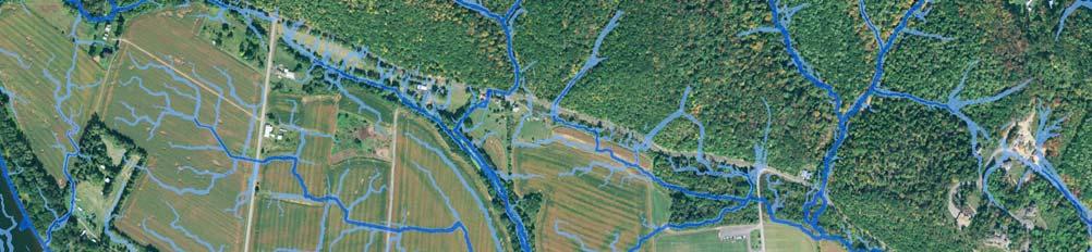
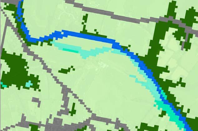
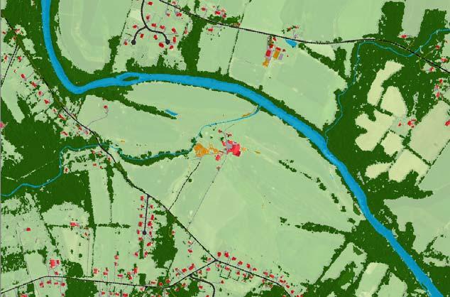
4 Lidar Flow Path Mapping Lidar Flow Path Mapping 4

5 Better data is only useful if it can be harnessed to inform better projects Goal: Identify priority locations for BMP implementation Pixel size: 1 meter by 1 meter resolution land cover High Resolution Land Cover & Concentrated Flow Paths 5


6 Pixel size: 1 meter by 1 meter Identified gaps in riparian forest buffer coverage 1.18 acres 1.16 acres Compare restoration opportunity areas 6

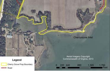
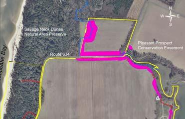
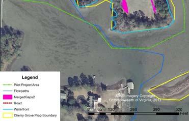
7 4.27 acres 59.7 acres 7


 Proximity to")


8 Assessing the landscape Criteria used in prioritization: Area of restoration opportunity Area of upland drainage area treated Land cover/land use in upland drainage area (runoff treatment potential) Proximity to Exceptional Value/High Quality Streams Proximity and upstream of Impaired Streams Data Land Cover/Use Flow Path Maps Prioritization Web based tools Access Products 8


9 Making Data Accessible Questions? conservationinnovationcenter.org 9


10 STRATEGIC CONSERVATION PLAN Kristin Kirkwood, Executive Director with funding from the Chesapeake Bay Land and Water Initiative, a project of the Chesapeake Bay Funders Network and the Land Trust Alliance BACKGROUND Founded in 1991 Single county geographic focus 1 FTE and 2 PTEs Annual operating budget approx. $150,000 Total assets approx. $4M Holds conservation easements or other restrictions on over 1,000 acres Owns approx. 350 acres in fee simple 10
11 STRATEGIC CONSERVATION PLAN OUTCOMES Articulate a science based conservation vision that incorporates both land and water elements Target and prioritize land conservation projects with greater precision and accountability Enhance HLT s image and credibility with partners, community members, and funders Facilitate learning and communication across key stakeholders ACTIVITIES Convene an advisory group of partner orgs. to leverage expertise, time, data and analysis, and GIS capacity Identify mutual and HLT specific conservation priorities and associated project selection criteria Use best available data and methods to analyze the County and target and prioritize regions/properties for HLT conservation Train HLT staff and transfer data and tools GIS COMPONENT Framing of analysis questions Exploration and preparation of spatial datasets Attribution of the Harford County parcel dataset with information about each property s standing against HLT s land conservation criteria Web viewer with parcel results Technical training for HLT s Executive Director 11


 Proximity to Protected Land RESULTS Direct Print maps Web viewer Excel data Indirect Stronger position")
12 GIS ANALYSIS ATTRIBUTES Top priority: Water, Farms, Wildlife/Biodiversity = 10 weight Chesapeake Bay Critical Area Line Agriculture Development Rights Targeted Ecological Areas Maryland Marsh Protection Potential Index Farm Lands Tier 1 3 Habitat Green Infrastructure Hubs and Corridors Ecologically Sensitive Areas Stream NHD Slope Land cover (Impervious) Middle Priority: Scenic, Size, and Location = 5 weight Proximity to Parks, County Historic Landmarks, National Register Individual Sites, and Scenic Trails, Maryland Scenic Byways, Historic Districts, etc. Cadastral (Size) Proximity to Protected Land RESULTS Direct Print maps Web viewer Excel data Indirect Stronger position with funders Targeted outreach Can easily say no! 12


13 LESSONS LEARNED Employ an iterative process Vet result with individuals with strong local knowledge Minor changes in attribute weighting/scales did not change results Make provisions for updating data and analysis as more information arises to avoid static information Local partners were more important for next steps rather than the analysis itself Questions? 13


14 Riparian Buffer Project with funding from the Chesapeake Bay Land and Water Initiative, a project of the Chesapeake Bay Funders Network and the Land Trust Alliance Hali Plourde-Rogers Executive Director, Virginia Eastern Shore Land Trust Summary Background Methods and Pilot Project Lessons Learned Resources 14

15 Background The Eastern Shore of Virginia 15
16 16
17 Methods Riparian Buffer Pilot Project Steps Science based data to analyze bayside easements Top 10 Determine what to plant Identify how to protect the new buffer Estimate cost 17

18 18

19 Lessons learned 19
20 Partners and resources Partners Chesapeake Conservancy Natural Resource Conservation Service VA Dept. of Conservation and Recreation, Natural Heritage Program VA United Land Trusts Virginia Outdoors Foundation Resources Virginia Coastal Geospatial and Educational Mapping System (Coastal Gems) The Nature Conservancy, Coastal Resilience Tool Thank you Questions? 20


21 10/17/2018 Tracking Easement Monitoring in a New Web based Mapping Application Jon Chapman Stewardship Manager Maryland Environmental Trust Saving the Chesapeake s Great Rivers and Special Places Maryland Environmental Trust (MET) Over 1100 easements to monitor on over 134,000 acres! Even more landowners than easements More than half of portfolio co held with our Local Land Trust Partners Saving the Chesapeake s Great Rivers and Special Places 21


22 MET monitoring process (before) Paper based Microsoft Access database Manual entry of report data and photo points Saving the Chesapeake s Great Rivers and Special Places Updated protocol for monitoring 1. Mobile field report form 2. Web application for display and storage Saving the Chesapeake s Great Rivers and Special Places 22


23 Integration with GIS Saving the Chesapeake s Great Rivers and Special Places Report display/products Summaries Report fields Photo points Downloads Summary report Zip of photos Easement map Saving the Chesapeake s Great Rivers and Special Places 23
")


24 Locate Integration LOCATE Monitoring reports Easement maps Photo summary/points Photo Zipfile Easement data & contacts management (CRM) Reporting tools & dashboards Due Diligence of CE restrictions Flag and track items of concern Saving the Chesapeake s Great Rivers and Special Places Connected Monitoring App Volunteers Local Land Trust Partners LOCATE Monitoring reports Photo summary Due Diligence Flags items of concern Connected! Easement management database Reporting tools Strategic stewardship of priority properties and landowners Saving the Chesapeake s Great Rivers and Special Places 24


25 10/17/2018 Contact Information Jon Chapman, Maryland Environmental Trust Michael Norton, Chesapeake Conservancy Saving the Chesapeake s Great Rivers and Special Places Final Questions? Rachel Soobitsky- rsoobitsky@chesapeakeconservancy.org Geospatial Project Manager Chesapeake Conservancy Conservation Innovation Center Kristin Kirkwood- kkirkwood@harfordlandtrust.org Executive Director Harford Land Trust Hali Plourde-Rogers- director@veslt.org Executive Director Virginia Eastern Shore Land Trust Jon Chapman- jon.chapman@maryland.gov Stewardship Manager Maryland Environmental Trust Saving the Chesapeake s Great Rivers and Special Places 25
Conservation Easement Stewardship
 Conservation Easements are effective tools to preserve significant natural, historical or cultural resources. Conservation Easement Stewardship Level of Service Standards March 2013 The mission of the
PROJECT SCORING GUIDANCE. Introduction: National Proiect Selection:
 FOREST LEGACY PROGRAM PROJECT SCORING GUIDANCE Introduction: This document provides guidance to the National Review Panel on how to score individual Forest Legacy Program (FLP) projects, including additional
Environment and Natural Resources Trust Fund Request for Proposals (RFP)
") Environment and Natural Resources Trust Fund 2012-2013 Request for Proposals (RFP) Project Title: Southeast Minnesota Sensitive Habitat Protection Program (SHPP) ENRTF ID: 067-D Topic Area: D. Land Acquisition
Environment and Natural Resources Trust Fund 2012-2013 Request for Proposals (RFP) Project Title: Southeast Minnesota Sensitive Habitat Protection Program (SHPP) ENRTF ID: 067-D Topic Area: D. Land Acquisition
MITIGATION POLICY FOR DISTRICT-PROTECTED LANDS
 MITIGATION POLICY FOR DISTRICT-PROTECTED LANDS Approved by the District Board of Directors on July 18, 2017 The following Mitigation Policy is intended to inform the evaluation of environmental mitigation-related
Land Transaction Procedures Approved July 17, 2012
 Land Transaction Procedures Approved July 17, 2012 Purpose: The Greenbelt Land Trust (GLT) acquires fee title or conservation easements for lands to fulfill its mission to conserve and protect in perpetuity
Kent Land Trust Strategic Reassessment Project Final Report
 Kent Land Trust Strategic Reassessment Project Final Report Prepared For: Connecticut Institute for Resilience and Climate Adaptation (CIRCA) Prepared by: Michael A. Benjamin, Land Steward, Kent Land Trust
Land Trust of Santa Cruz County. Strategic Plan. July 2012 to June This is a public version of a more detailed internal plan.
 Land Trust of Santa Cruz County Strategic Plan July 2012 to June 2015 This is a public version of a more detailed internal plan. Over the next three years the Land Trust will pursue four critical strategies.
Chapter 10: Implementation
 Chapter 10: Introduction Once the Comprehensive Plan has been adopted by the City of Oakdale, the City can begin to implement the goals and strategies to make this vision a reality. This chapter will set
Updated - A Report on the County of Arlington s Existing and Possible Urban Tree Canopy
 Updated - A Report on the County of Arlington s Existing and Possible Urban Tree Canopy Key Terms UTC: Urban tree canopy (UTC) is the layer of leaves, branches, and stems of trees that cover the ground
Siskiyou Land Trust. Strategic Plan Update
 Siskiyou Land Trust Strategic Plan Update 2018-2023 Issued by the Board of Directors of Siskiyou Land Trust, May 2018 Our Mission: The Siskiyou Land Trust is dedicated to long-term stewardship of agricultural,
Protected Lands Outcome Management Strategy
 Protected Lands Outcome Management Strategy Photo Courtesy Tom Lussier/Paris, VA in Springtime Introduction In 2015, we stand at a critical juncture relative to land protection in the Chesapeake watershed.
Before the meeting starts: Please circle the area your land trust works on the wall poster and note the land trust name
 Before the meeting starts: Please circle the area your land trust works on the wall poster and note the land trust name GIS in land conservation. Brian Hall brianhallconservation@gmail.com 10/3/2017 What
Protected Lands Outcome
 Protected Lands Outcome Management Strategy 2015 2025, v.2 The headwaters of the Rapidan River are seen near Skyline Drive in Shenandoah National Park. (Photo by Will Parson/Chesapeake Bay Program) I.
CATALOGING, MONITORING AND MANAGING INVASIVE SPECIES ON POST LANDS. PSU Geog596A Capstone Proposal Dale Jantzen Dec 17, 2015
 CATALOGING, MONITORING AND MANAGING INVASIVE SPECIES ON POST LANDS PSU Geog596A Capstone Proposal Dale Jantzen Dec 17, 2015 PROJECT OUTLINE AND PURPOSE Define a particular need within a non-profit land
PROTECTING THE CHESAPEAKE BAY WATERSHED. C. Ronald Franks Audrey Scott
 MARYLAND S LAND CONSERVATION PROGRAMS PROTECTING THE CHESAPEAKE BAY WATERSHED Robert L. Ehrlich, Jr. Governor Department of Agriculture Lewis R. Riley Secretary Michael S. Steele Lt. Governor Department
Implementation Guidance for The Sustainable Growth and Agricultural Preservation Act of 2012 Senate Bill 236
 Implementation Guidance for The Sustainable Growth and Agricultural Preservation Act of 2012 Senate Bill 236 May 22, 2012 Version 1.0 Table of Contents 1. Executive Summary... 1 1.1 Bill Highlights...
Georgia Conservation Tax Credit Program Frequently Asked Questions
 Georgia Conservation Tax Credit Program Frequently Asked Questions What are the minimum requirements for eligibility under the Georgia Conservation Tax Credit Program (GCTCP)? Individual and corporate
Easement Program Guidelines for Water Resources and Stream Work
 Easement Program Guidelines for Water Resources and Stream Work The following guidelines are established by the Easement Committee to create standards for reviewing requests by landowners to conduct stream
2018 Highlands Region Land Preservation Status Report
 2018 Highlands Region Land Preservation Status Report Highlands Development Credit (HDC) properties (l to r): Tewksbury Township, Hunterdon County; Mount Olive, Morris County; Independence Township, Warren
Using Easements to Conserve Biodiversity. Jeff Lerner Defenders of Wildlife
 Using Easements to Conserve Biodiversity Jeff Lerner Defenders of Wildlife jlerner@defenders.org Northeast LTA June 10, 2006 Defenders of Wildlife Mission: to protect native wild animals and plants in
Central Pennsylvania Conservancy Project Selection Criteria Form
 Central Pennsylvania Conservancy Project Selection Criteria Form The following criteria guide the actions of the Central Pennsylvania Conservancy s Land Protection Committee and Board of Directors in selecting
Land Conservation Agreements Project Guidance
 Land Conservation Agreements Project Guidance Stakeholder Informed OTHER OPTIONS Introduction Enhanced or permanent protection of corporate lands through land conservation agreements means that companies
CHAPTER 6 CHESAPEAKE BAY PRESERVATION AREAS AND STREAM PROTECTION AREAS
 CHAPTER 6 CHESAPEAKE BAY PRESERVATION AREAS AND STREAM PROTECTION AREAS 6.1 INTRODUCTION Virginia s Chesapeake Bay Preservation Area (CBPA) Designation and Management Regulations (9VAC10-20 et seq.) require
Environment and Natural Resources Trust Fund (ENRTF) M.L Work Plan
 M.L Work Plan") Environment and Natural Resources Fund (ENRTF) M.L. 2015 Work Plan Date of Report: May 14, 2015 Date of Next Status Update Report: February 1, 2016 Date of Work Plan Approval: Project Completion Date:
Environment and Natural Resources Fund (ENRTF) M.L. 2015 Work Plan Date of Report: May 14, 2015 Date of Next Status Update Report: February 1, 2016 Date of Work Plan Approval: Project Completion Date:
Texas Parks and Wildlife Foundation Buffer Lands Program Program Description and Application
 Texas Parks and Wildlife Foundation Texas Parks and Wildlife Foundation s mission is to provide private support to Texas Parks and Wildlife Department to manage and conserve the natural and cultural resources
Participants of the Ministerial Meeting on Housing and Land Management on 8 October 2013 in Geneva
 Summary At its meeting on 2 April 2012, the Bureau of the Committee on Housing and Land Management of the United Nations Economic Commission for Europe agreed on the need for a Strategy for Sustainable
OPEN SPACE PRESERVATION. Reflections on the Value of Acquiring Property for Preservation Purposes
 OPEN SPACE PRESERVATION Reflections on the Value of Acquiring Property for Preservation Purposes What is open space and what does it do? The Town Plan of Conservation and Development defines it as follows:
General Development Plan Background Report on Agricultural Land Preservation
 General Development Plan 2008 Background Report on Agricultural Land Preservation February 2008 I. Introduction Anne Arundel County has been an agricultural community for over 350 years, beginning with
Introduction to INRMP Implementation Options
 El Dorado County Integrated Natural Resources Management Plan Introduction to INRMP Implementation Options 1 Our approach to the options evaluation is based on the INRMP components as they are currently
Goals for Today s Session. Understand Best Practices for sound real estate transactions. Learn tips & tricks to implement
 Anatomy of A Real Estate Transaction Texas Land Conservation Conference March 1, 2017 Goals for Today s Session Understand Best Practices for sound real estate transactions Learn tips & tricks to implement
Easement Program Guidelines for Locating Towers and Communication Devices
 Easement Program Guidelines for Locating Towers and Communication Devices The following guidelines are established by the Easement Committee to create standards for reviewing requests by landowners to
Implementation Guidance. for. The Sustainable Growth and Agricultural Preservation Act of Senate Bill 236
 Implementation Guidance for The Sustainable Growth and Agricultural Preservation Act of 2012 Senate Bill 236 August 1, 2012 Version 2.0 Table of Contents 1. Executive Summary... 1 1.1 Bill Highlights...
Crediting Conservation: Frequently Asked Questions
 Crediting Conservation: Frequently Asked Questions 1) How and who developed the Conservation Plus family of land use scenarios, also known as Land Policy Best Management Practices (BMPs)? The Conservation
Development and Updates of Protected Lands Databases in the US (PAD-US, NCED, CARL)
") Development and Updates of Protected Lands Databases in the US (PAD-US, NCED, CARL) Robb Macleod, National GIS Coordinator at Ducks Unlimited rmacleod@ducks.org 734-623-2004 Overview 1. What is the NCED,
Development and Updates of Protected Lands Databases in the US (PAD-US, NCED, CARL) Robb Macleod, National GIS Coordinator at Ducks Unlimited rmacleod@ducks.org 734-623-2004 Overview 1. What is the NCED,
Wood River Land Trust Staff Report
 Wood River Land Trust Staff Report Date: July 9, 2014 To: Board of Directors From: Staff, Keri York Regarding: MacConnell Agricultural Lands Easement Action Item Action Item: The item for consideration
Module 2. Chesapeake Bay Trust Watershed Restoration Project Management Training. Owners & Stakeholders Jim Morris, P.E.
 Chesapeake Bay Trust Watershed Restoration Project Management Training Module 2 Project Planning Andrew Birmingham, P.E. Owners & Stakeholders Jim Morris, P.E. Learning Objectives Learn how to find property
Sample Baseline Documentation Report (BDR) Annotated Template for Environmentally Important Land
 Annotated Template for Environmentally Important Land") Sample Baseline Documentation Report (BDR) Annotated Template for Environmentally Important Land The baseline documentation report (BDR) provides a snap shot of the biophysical condition of a property
Sample Baseline Documentation Report (BDR) Annotated Template for Environmentally Important Land The baseline documentation report (BDR) provides a snap shot of the biophysical condition of a property
APPENDIX B. Fee Simple v. Conservation Easement Acquisitions NTCOG Water Quality Greenprint - Training Workshops
 APPENDIX B Fee Simple v. Conservation Easement Acquisitions NTCOG Water Quality Greenprint - Training Workshops Lake Arlington Watershed and Lewisville Lake East Watershed June 21, 2011 Presenter Talking
State of Washington Project Luke Rogers, University of Washington March 2010
 State of Washington Project Luke Rogers, University of Washington March 2010 Rural Technology Initiative (RTI) developed an online tutorial on how to use the Washington State Parcel and Forestland Databases
ARLINGTON COUNTY, VIRGINIA. County Board Agenda Item Meeting of June 17, 2017
 ARLINGTON COUNTY, VIRGINIA County Board Agenda Item Meeting of June 17, 2017 DATE: June 9, 2017 SUBJECT: Request to authorize advertisement of public hearings by the Planning Commission and County Board
Minnesota Water Quality and Habitat Conservation Reserve Enhancement Program (MN CREP) Overview February 14, 2017
 Overview February 14, 2017") Minnesota Water Quality and Habitat Conservation Reserve Enhancement Program (MN CREP) Overview February 14, 2017 1 MN Conservation Reserve Enhancement Program (MN CREP) General Overview Practices, Outcomes,
Minnesota Water Quality and Habitat Conservation Reserve Enhancement Program (MN CREP) Overview February 14, 2017 1 MN Conservation Reserve Enhancement Program (MN CREP) General Overview Practices, Outcomes,
Memorandum of Understanding between County Board of Arlington County, Virginia and The Northern Virginia Conservation Trust
 Memorandum of Understanding between County Board of Arlington County, Virginia and The Northern Virginia Conservation Trust In consideration of the County Board of Arlington County (the County ) having
113,923,000. Article 1 Sec moves to amend H.F. No as follows: 1.2 Delete everything after the enacting clause and insert:
 1.1... moves to amend H.F. No. 4167 as follows: 1.2 Delete everything after the enacting clause and insert: 1.3 "ARTICLE 1 1.4 OUTDOOR HERITAGE FUND 1.5 Section 1. OUTDOOR HERITAGE APPROPRIATION. 1.6 The
Techniques for Stewardship of Preserved Farms: Three Programs Saving America s Farms and Farmland Conference
 Techniques for Stewardship of Preserved Farms: Three Programs Saving America s Farms and Farmland Conference May 13, 2014 June Mengel, Farmland Preservation Specialist, Lancaster County, Pennsylvania Chuck
FLORENCE NEIGHBORHOOD REVITALIZATION
 FLORENCE NEIGHBORHOOD REVITALIZATION South Carolina American Planning Association Conference Fall 2015 AGENDA Introductions Project Overview Planning Goals Process Recommendations Implementation Questions
Real Estate Strategic Plan: Port Commission Final Presentation
 Item No. 7a_supp Date of Meeting October 25 th, 2016 Real Estate Strategic Plan: Port Commission Final Presentation October 25 th, 2016 1 Overview I. Real Estate Plan Objectives II. Real Estate Development
Regional Conservation Partnerships
 Regional Conservation Partnerships How they benefit land trusts and other partners Presented by Bill Labich, Senior Conservationist, Highstead Foundation 2017 Maryland Land Conservation Conference June
Middle Peninsula Conservation Corridor Plan
 Middle Peninsula Conservation Corridor Plan Middle Peninsula Planning District Commission 2010 As population within the Middle Peninsula rises, conservation corridor planning provides an option for localities
Community Associations & Maryland's New Stormwater Fees
 2018 Whiteford, Taylor & Preston LLP Community Associations & Maryland's New Stormwater Fees May 1, 2013 Highlight: Maryland has new local stormwater fees that will be implemented in certain counties beginning
LIVING LANDS BIODIVERSITY GRANTS: INFORMATION AND APPLICATION. Due: January 16, 2009
 LIVING LANDS BIODIVERSITY GRANTS: INFORMATION AND APPLICATION Due: January 16, 2009 PURPOSE OF LIVING LANDS PROJECT Defenders of Wildlife s Living Lands project provides financial, technical and educational
Chapter 10 Local Protection Measures
 The DPC fully supports the protection of private property rights and the DPC will work to ensure that there will be no negative impacts stemming from NHA activities on private property, should the designation
Next Generation Stewardship: Ensuring the Long-term Viability of Conservation Easements
 N Next Generation Stewardship: Ensuring the Long-term Viability of Conservation Easements The Big Question How do we preserve conservation purposes in a changing world? Keys to Long-Term Viability of Easements
Canadian Land Trust - Standards and Practices
 Canadian Land Trust - Crosswalk Comparison: 2005 to Standard 1: Ethics, Mission and Community Engagement 1A Mission 1B Planning and 1B Mission, Planning and Evaluation Reworded: Practices 1A and 1B combined.
The GIS Behind Dakota County s FARMLAND AND NATURAL AREAS PROGRAM
 The GIS Behind Dakota County s FARMLAND AND NATURAL AREAS PROGRAM The Farmland and Natural Areas Program is a voluntary program in which Dakota County and other partners work with willing landowners to
OPEN-SPACE CONVERSION REQUEST
 OPEN-SPACE CONVERSION REQUEST Applicant: Board Meeting: February 9, 2017 Landowner: Normandy Capital, LLC VOF Easement: BAT-03678 Table of Contents: Cover Page 1 Table of Contents 2 Application Overview
Purpose: Regulations:
 Administrative Procedures for the Designation and Refinement Of Chesapeake Bay Preservation Area Boundaries Guidance on the Chesapeake Bay Preservation Area Designation and Management Regulations September,
National Spatial Data Infrastructure development in Republic of Macedonia
 National Spatial Data Infrastructure development in Republic of Macedonia Sonja Dimova, state advisor for geomatics AGENCY FOR REAL ESTATE CADASTRE September 6-th, 2017, Strasbourg AREC competence for
UNOFFICIAL COPY OF HOUSE BILL 1272 A BILL ENTITLED
 UNOFFICIAL COPY OF HOUSE BILL 1272 M4 6lr0525 By: Delegates Smigiel, Kelley, Rosenberg, and Sossi Introduced and read first time: February 10, 2006 Assigned to: Environmental Matters 1 AN ACT concerning
Conservation Design Subdivision Option
 Sheridan County, Wyoming Conservation Design Subdivision Option Recent Amendments to Zoning and Subdivision Rules and Regulations Adopted November 2010 Mark Reid, County Planner 1 County Road #255 traffic
Conservation Easement Best Management Practices
 Conservation Easement Best Management Practices Natural Resources Department April 2013 The mission of the Larimer County Natural Resources Department is to establish, protect and manage significant regional
OPEN SPACE & RECREATION PLAN
 OPEN SPACE & RECREATION PLAN HOPEWELL TOWNSHIP Cumberland County, New Jersey Prepared by: Hopewell Township Environmental Commission Final October 2011 (THIS PAGE INTENTIONALLY LEFT BLANK) PUBLIC MEETINGS
NSW Travelling Stock Reserves Review Public consultation paper
 NSW Travelling Stock Reserves Review Public consultation paper A collaborative project between: Local Land Services Department of Industry Lands Contents Executive summary 2 1. About TSRs 3 What are TSR
SPECIFIC RESPONSES TO AREA COMMISSION OPPOSITION :
 SPECIFIC RESPONSES TO AREA COMMISSION OPPOSITION 3-14-19: Area Commission reasons for opposition in black APPLICANT S RESPONSE IN RED. The comprehensive planning and design of stream restoration efforts
FGDC Cadastral Data Subcommittee. December 2008
 FGDC Cadastral Data Subcommittee Annotated Bibliography: Foundational Documents for Building a Cadastral National Prepared by David Stage and Nancy von Meyer for the FGDC Cadastral Data Subcommittee Annotated
Staying Connected in the Northern Appalachians
 Staying Connected in the Northern Appalachians Potential Conservation Easement Provisions Designed to Explicitly Address Connectivity in the Northern Appalachians Updated and Revised May 2012 In this document,
APPENDIX B COMPLIANCE WITH THE GOVERNMENT CODE
 APPENDIX B COMPLIANCE WITH THE GOVERNMENT CODE A. GENERAL PLAN AMENDMENT PROCEDURE In general, local governments may not amend any of the mandatory elements of the General Plan (e.g. Land Use, Open Space,
GOVERNMENT. Case Study Ville de Trois Rivières streamlines property assessment
 GOVERNMENT Case Study Ville de Trois Rivières streamlines property assessment GIS-generated parcel basemap provides powerful visualization & analysis capabilities With a population of just over 130,000,
Claudia Stuart, Williamson Act Program Manager and Nick Hernandez, Planning Intern
 Land Conservation (Williamson) Act Advisory Committee STAFF REPORT September 15, 2014 Prepared by: Claudia Stuart, Williamson Act Program Manager and Nick Hernandez, Planning Intern Subject: Discussion:
Resource Protection Area Map Update - Frequently Asked Questions
 DEPARTMENT OF ENVIRONMENTAL SERVICES Office of Sustainability and Environmental Management 2100 Clarendon Boulevard, Suite 705, Arlington, VA 22201 TEL 703-228-4488 FAX 703-228-7134 TTY 703-228-4611 www.arlingtonva.us
Yolo Habitat Conservancy County of Yolo City of Davis City of Winters City of West Sacramento City of Woodland University of California, Davis
 Yolo Habitat Conservancy County of Yolo City of Davis City of Winters City of West Sacramento City of Woodland University of California, Davis Science & Technical Advisory Committee (STAC) Operational
Position Specification
 Position Specification Chief Real Estate Officer 07 June 2017 Carlson Beck advises Habitat for Humanity Greater San Francisco on the basis of an exclusive consulting assignment. POSITION SPECIFICATION
Denver Comprehensive Housing Plan. Housing Advisory Committee Denver, CO August 3, 2017
 Denver Comprehensive Housing Plan Housing Advisory Committee Denver, CO August 3, 2017 Overview 1. Review of Comprehensive Housing Plan process 2. Overview of legislative and regulatory priorities 3. Overview
Greene Land Trust. Balancing Sound Development and Effective Conservation
 Balancing Sound Development and Effective Conservation Comprehensive Approach The is dedicated to protecting the many places that make Greene County such a special place: Scenic vistas that inspired the
2011 AICP Review Course
 2011 AICP Review Course March 2011 Alex Dambach, AICP, PP Director of Policy, Planning, and Development City of East Orange Exam Content A. Strategic planning/visioning B. Goal setting C. Research methods
Bureau of Land Management MAPPS Federal Update Donald Buhler Cadastral, Lands, and Realty Management April 14, 2015
 Bureau of Land Management MAPPS Federal Update Donald Buhler Cadastral, Lands, and Realty Management April 14, 2015 Division of Cadastral, Lands and Realty Management 1 BLM Mission Manages 247 million
Lessard Sams Outdoor Heritage Council
 Lessard Sams Outdoor Heritage Council MEMO: Agenda Item # 10 DATE: December 11, 2014 SUBJECT: PRESENTER: 2015 Legislative Appropriation Recommendation Bill Heather Koop, LSOHC staff Background: On October
Conservation Easements & Public Access Are Not Mutually Exclusive! Colorado Coalition of Land Trusts Conservation Excellence
 Conservation Easements & Public Access Are Not Mutually Exclusive! Colorado Coalition of Land Trusts Conservation Excellence - 2016 GOAL: How to Design, fund, and steward conservation easement projects
TERRA. Forest CORE Fund Project Application. Applicant Information Applicant Partner Organization Contact Person
 TERRA Forest CORE Fund Project Application Applicant Information Applicant Partner Organization Contact Person Phone Number Address Type of Applicant/ Partner Organization Title Email Address Federal State
Dakota County Farmland and Natural Areas Program. Lake Pepin TMDL May 31, 2007
 Dakota County Farmland and Natural Areas Program Lake Pepin TMDL May 31, 2007 Presentation Overview County Context FNAP Planning Process FNAP Implementation Integrating Conservation Efforts Parcel Development
Please review the Draft PTF Grant Manual with the above background information in mind. AGC
 Board of Trustees Anna G. Chisholm, PTF Program Administrator 3.15.2017 Proposed Updates to the PTF Grant Manual The PTF Grant Manual was last updated in 2006 and many details of the easement process have
Our Focus: Your Future NATURE CONSERVANCY OF CANADA ACQUISITION OF PHILIPS PROPERTY
 Town of Fort Erie Community & Development Services Our Focus: Your Future Prepared for Council-in-Committee Report No. CDS-47-7 Agenda Date June 11, 27 File No. 1292 Subject NATURE CONSERVANCY OF CANADA
Final Report: Conserving the Pugwash Estuary
 Final Report: Conserving the Pugwash Estuary Habitat Conservation Fund Grant to Nature Conservancy of Canada, Atlantic Region Report Prepared by: Craig Smith Nova Scotia Program Manager November 20 th,
EASEMENTS: Fiscal Impacts to Localities in the. Jackie Rickards Middle Peninsula Planning District Commission July 13, 2011
 CONSERVATION EASEMENTS: Fiscal Impacts to Localities in the Middle Peninsula Jackie Rickards Middle Peninsula Planning District Commission July 13, 2011 1 Location of the Middle Peninsula Middle Peninsula
BOUNDARY MANAGEMENT AND ENCROACHMENTS
 BOUNDARY MANAGEMENT AND ENCROACHMENTS 1 255 255 255 237 237 237 0 0 0 217 217 217 163 163 163 200 200 200 Open Forum Discussion on Challenges and Best Management Practices 131 132 122 239 65 53 80 119
Land Conservation 101. Chris LaPointe, Director of Land Conservation Essex County Greenbelt Association
 Land Conservation 101 Chris LaPointe, Director of Land Conservation Essex County Greenbelt Association Greenbelt 34 cities and towns of Essex County 17,500 acres of land since 1961 Nearly 6,000 acres comprise
APPLICATION FOR PERMIT: (Pursuant to Ord & Reso ) 4d Habitat Loss Permit Vegetation Removal Tree Removal. Address:
 4d Habitat Loss Permit Vegetation Removal Tree Removal. Address:") CITY OF ESCONDIDO Planning Division 201 North Broadway Escondido, CA 92025-2798 (760) 839-4671 Fax: (760) 839-4313 APPLICATION FOR PERMIT: (Pursuant to Ord. 91-54 & Reso. 94-436) Case No: FOR INTERNAL
CITY OF ESCONDIDO Planning Division 201 North Broadway Escondido, CA 92025-2798 (760) 839-4671 Fax: (760) 839-4313 APPLICATION FOR PERMIT: (Pursuant to Ord. 91-54 & Reso. 94-436) Case No: FOR INTERNAL
TransNet Environmental Mitigation Program: Land Acquisition and Restoration Process and Criteria
 TransNet Environmental Mitigation Program: Land Acquisition and Restoration Process and Criteria On September 26, 2008, the San Diego Association of Governments Board of Directors (BOD) approved the attached
PROJECT INFORMATION DOCUMENT (PID) APPRAISAL STAGE Report No.: PIDA Project Name. Region Country Sector(s) Theme(s)
 APPRAISAL STAGE Report No.: PIDA Project Name. Region Country Sector(s) Theme(s)") Public Disclosure Authorized Public Disclosure Authorized Public Disclosure Authorized Public Disclosure Authorized Project Name Region Country Sector(s) Theme(s) Lending Instrument Project ID Borrower(s)
Public Disclosure Authorized Public Disclosure Authorized Public Disclosure Authorized Public Disclosure Authorized Project Name Region Country Sector(s) Theme(s) Lending Instrument Project ID Borrower(s)
Innovative Local Government Land Conservation Techniques
 Innovative Local Government Land Conservation Techniques Three new successful land conservation programs used in Maryland by Baltimore and Carroll Counties are worthy of further examination. Baltimore
Affordable Housing Incentives. Regional TOD Advisory Committee June 15, 2018
 Affordable Housing Incentives Regional TOD Advisory Committee June 15, 2018 August 2, 2017 GTC: Affordable Housing Incentives Strategy 17: Leverage Market Value through Incentives for Affordability Technical
Colorado Parks and Wildlife. Acquisition Selection for the Colorado Wildlife Habitat Protection Program
 Colorado Parks and Wildlife Acquisition Selection for the Colorado Wildlife Habitat Protection Program State Wildlife Action Plan and CPW s Strategic Plan: *Conserve wildlife and habitat to ensure healthy
Assessor. Mission Statement: Functions: Long Term Goals: Page 1 of 6
 Assessor Mission Statement: The mission of the Assessor s Office is to create accurate, equitable, and timely property tax assessments to fund public services; and to be a source of current, accurate property
Statewide land trust with focus on coast. 42 Years, more than 3,700 members. MLTN program supports 93 land trusts
 Statewide land trust with focus on coast 42 Years, more than 3,700 members 1,168 Projects 137,000 acres 297 whole islands currently own and manage 49 islands including the 1,000 acre Ed Woodsum Preserve
Town of Falmouth s Four Step Design Process for Subdivisions in the Resource Conservation Zoning Overlay District
 Town of Falmouth s Four Step Design Process for Subdivisions in the Resource Conservation Zoning Overlay District All subdivisions shall be designed in accordance with the following four-step process.
2026 Campus Plan. September 19, 2016
 PRINCETON UNIVERSIT Y 2026 Campus Plan September 19, 2016 In association with: Vanasse Hangen Brustlin, Inc. Michael Van Valkenburgh Associates Inc. KPMB Architects BFJ Planning Burns & McDonnell Level
Land Tenure and Geospatial Data and Technology
 Land Tenure and Geospatial Data and Technology Ioana Bouvier E3/Land and Urban, USAID Senior Geospatial Analyst January 23, 2018 January 23, 2018 1 OUTLINE 1. Overview of geospatial data and technology
CONSERVING TREASURED LANDSCAPES IN THE CHESAPEAKE Appendix FRIENDS OF THE JOHN SMITH CHESAPEAKE TRAIL REPORT
 CONSERVING TREASURED LANDSCAPES IN THE CHESAPEAKE Appendix FRIENDS OF THE JOHN SMITH CHESAPEAKE TRAIL REPORT Prepared by the Environmental Law Institute November 2009 Appendix: Program Descriptions Selected
Update on the Avenues and Mid-Rise Buildings Action Plan
 STAFF REPORT INFORMATION ONLY Update on the Avenues and Mid-Rise Buildings Action Plan Date: May 15, 2009 To: From: Wards: Reference Number: Planning and Growth Management Committee Chief Planner and Executive
Request to Advertise: Chesapeake Bay Preservation Area (CBPA) Map Update. June 20, 2017
 Map Update. June 20, 2017") Request to Advertise: Chesapeake Bay Preservation Area (CBPA) Map Update June 20, 2017 Outline Context Past County Board actions Why update the CBPA Map? What and Why - Resource Protection Areas Property
Request to Advertise: Chesapeake Bay Preservation Area (CBPA) Map Update June 20, 2017 Outline Context Past County Board actions Why update the CBPA Map? What and Why - Resource Protection Areas Property
Open Space. Introduction. Vision. Defining Open Space. Midway City 2017 General Plan
 Open Space Midway City 2017 General Plan Introduction The importance of preserving open space to meet the goals and objectives of the General Plan cannot be overstated. Indeed, references to preserving