The Multipurpose Marine Cadastre A Tool for Planning & Decision Making in the Marine Environment
|
|
|
- Morgan Benson
- 6 years ago
- Views:
Transcription
1 The Multipurpose Marine Cadastre A Tool for Planning & Decision Making in the Marine Environment Christine Taylor Minerals Management Service (MMS) Brian Smith NOAA Coastal Services Center Maurice Hill Minerals Management Service (MMS)
2 Multipurpose Marine Cadastre Presentation Outline MMC Overview Partnerships Data and Viewers Case Studies
3 Multipurpose Marine Cadastre A marine information system for the outer continental shelf and state waters that provides a data framework to support decision making.
4 Multipurpose Marine Cadastre History Energy Policy Act of 2005 Section 388 Alternate Energy Related Uses on the Outer Continental Shelf (OCS) Develop an OCS mapping initiative Marine Boundary Working Group developed an implementation plan called the multipurpose marine cadastre Multi-year, interagency plan which focuses on... Data compilation Data access, standardization, and viewing Case studies Partnership development Capacity building
5 Partners and Providers Current Partnerships Minerals Management Service (lead) NOAA Coastal Services Center (technical lead) NOAA Office of Coast Survey NOAA National Marine Sanctuaries NOAA Marine Protected Areas NOAA Fisheries USGS U.S. Fish and Wildlife Service National Park Service Federal Energy Regulatory Commission The Nature Conservancy California Coastal Conservancy Potential Partnership Opportunities Department of Defense (DoD) Coast Guard Massachusetts Coastal Zone Mgmt. Rhode Island CRMC Washington State Dept. of Ecology Department of Energy South Carolina OCRM Northeast Regional Ocean Council Other States

6 Land-Based Cadastre Example Multipurpose Marine Cadastre Marine-Based Cadastre Example
7 What is a Marine Cadastre? A marine cadastre is a system to enable the boundaries of maritime rights and interests to be recorded, spatially managed and physically defined in relationship to the boundaries of other neighboring or underlying rights and interests. (Robertson et al., 1999)
8
9 Multipurpose Marine Cadastre Data Themes Marine Cadastre Georegulations Marine Infrastructure & Navigation Geology and Seafloor * Marine Habitat and Biodiversity * Human Uses * Base Maps * Denotes significant gaps in data
10 So, Things Like: Offshore Wind Projects
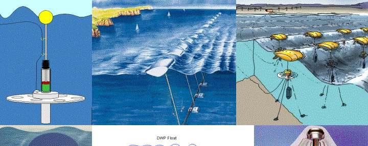

11 Alternative forms of wave energy
12
13 Why is the Multipurpose Marine Cadastre Important? Improves coordination and decision making Tool to resolve and modernize boundaries Tool for new data Relevant to all ocean planning issues Reduces data costs for states and other organizations
14 MMC - Data Management Vision Data needed to support ocean planning and management is available from the authoritative source in an easily accessible format so that end users can visualize and access data for their specific needs.
15 MMC - Data Access and Management Data is managed and maintained by the authoritative source The Center harvests on a periodic basis to keep the viewers up to date Access is provided via the Marine Boundary Working Group data portal Working on a series of data bundles Core marine cadastre Marine Infrastructure ENCs Georegulations Version 1 Configuration


16 MMC - Viewers Web-based and client-side ArcIMS ArcReader Google Earth Provides access to data Map-making functionality Used for decision support Driven by partner needs


17 Case Studies Criteria: Meets customer needs Meets project objectives Builds collective capacity Available resources How we engage depends on level of partner capacity


18 Case Studies Partners: Minerals Management Service and NOAA CSC Issue: Alternative Energy Development on the OCS Task: Develop mapping applications to support energy planning and regulations Status: Ongoing effort


19 Case Studies Partner: NOAA NMFS Habitat Conservation Division Issues: Map hydrokinetic projects and critical habitat data; system to support permit review Status: Ongoing; figuring out best way to collaborate


20 Case Studies California Coastal Conservancy using data and maps for wave energy studies Providing web map services for state ocean planning
21 West Coast Initiatives Federal NOAA Coastal Services Center Geospatial tools and services Regional Coordination Marine Protected Area (MPA) Center Developing framework for a national system of MPAs California Ocean Uses Atlas Project National Marine Sanctuaries National Marine Fisheries Service Essential Fish Habitat Mapper Fisheries GIS Portal Hydrokinetic Mapping Project - West Coast
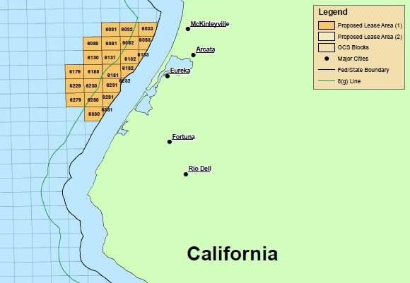
22 Demonstration Scenario: Permit review or site selection for energy projects Location: State and Federal Waters off of Northern California Users: NMFS, State Permitting Offices, private sector
23 In Summary MMC is issue driven Gaining momentum through case studies and partnerships Scalable and transferrable Products and support include: Authoritative marine boundary and supporting data Stand-alone and customizable data viewers Templates for developing map viewers Support on a case-by-case basis
24 MMC Future Activities Work to achieve our vision of a distributed system Integrate biology, benthic, and human use data Provide a range of visualization and analysis options Capitalize on emerging partnership opportunities (e.g. ESRI, Google, Academia) Engage in demonstration projects, e.g. decision support for MSP, enhanced tools for renewable energy
25 Contacts Christine Taylor, MMS Brian Smith, NOAA CSC Web access points:
FGDC Cadastral Data Subcommittee. December 2008
 FGDC Cadastral Data Subcommittee Annotated Bibliography: Foundational Documents for Building a Cadastral National Prepared by David Stage and Nancy von Meyer for the FGDC Cadastral Data Subcommittee Annotated
Theme Strategic Plan for Cadastral Theme
 Theme Strategic Plan for Cadastral Theme Bureau of Land Management Cadastral Survey Federal Geographic Data Committee (FGDC) 2017 2021 April 2017 - Progress and Update Cadastral Theme Implementation Plan
Marine Spatial Data Infrastructure (MSDI) & The Marine Cadastre Application. April 10, 2018
 & The Marine Cadastre Application. April 10, 2018") Marine Spatial Data Infrastructure (MSDI) & The Marine Cadastre Application April 10, 2018 A Collaborative Pilot Project Vision of CHS: A framework of geographic data, metadata, users and tools Intent
Marine Spatial Data Infrastructure (MSDI) & The Marine Cadastre Application April 10, 2018 A Collaborative Pilot Project Vision of CHS: A framework of geographic data, metadata, users and tools Intent
Developing a Prototype Marine Cadastre for Chedabucto Bay, Nova Scotia, Canada or is it St. Margaret s Bay?
 Developing a Prototype Marine Cadastre for Chedabucto Bay, Nova Scotia, Canada or is it St. Margaret s Bay? Dr. Michael Sutherland, CANADA Chair-Elect, Commission 4 FIG EILAT 2009, FIG WORKING WEEK, EILAT,
Modernizing Land Administration Systems
 Presented at the FIG Congress 2018, May 6-11, 2018 in Istanbul, Turkey Modernizing Land Administration Systems B r e n t J o n e s P E, PLS E s r i Land Administration Systems GIS is the Technology Platform
Towards European Marine Cadastral system
 Baltic Sea region MSP Data Expert Sub-Group 7 th meeting Helsinki, Finland, 13-14 September 2017 Towards European Marine Cadastral system Rik Wouters ( WPLA/EULIS) Evangelia Balla (PCC/NCMA) Acknowledgement
Bureau of Land Management MAPPS Federal Update Donald Buhler Cadastral, Lands, and Realty Management April 14, 2015
 Bureau of Land Management MAPPS Federal Update Donald Buhler Cadastral, Lands, and Realty Management April 14, 2015 Division of Cadastral, Lands and Realty Management 1 BLM Mission Manages 247 million
National Spatial Data Infrastructure development in Republic of Macedonia
 National Spatial Data Infrastructure development in Republic of Macedonia Sonja Dimova, state advisor for geomatics AGENCY FOR REAL ESTATE CADASTRE September 6-th, 2017, Strasbourg AREC competence for
Real Estate Administration at the Vancouver Port Authority (VPA) Presentation by Ron McMillan - GIS/LIS Coordinator December 13, 2004
 Presentation by Ron McMillan - GIS/LIS Coordinator December 13, 2004") Real Estate Administration at the Vancouver Port Authority (VPA) Presentation by Ron McMillan - GIS/LIS Coordinator December 13, 2004 Introduction Overview of the Vancouver Port Authority (VPA) How CAD
Real Estate Administration at the Vancouver Port Authority (VPA) Presentation by Ron McMillan - GIS/LIS Coordinator December 13, 2004 Introduction Overview of the Vancouver Port Authority (VPA) How CAD
Cadastral NSDI Reference Document
 Cadastral NSDI Reference Document Version 12 October 2012 FGDC Subcommittee for Cadastral Data Cadastral NSDI Reference Document Table of Contents 1. Purpose... 1 2. Business Applications... 1 3. Terminology
Egyptian Nationwide Title Cadastre System
 Kholoud SAAD, Egypt Key words: Cadastre, Registration, Urban, Rural, National Cadastre, Automation, reengineering. SUMMARY With growing need for integrated information, Enterprise Solutions has become
FGDC SUBCOMMITTEE FOR CADASTRAL DATA. October 2004 Albuquerque, New Mexico Meeting
 FGDC SUBCOMMITTEE FOR CADASTRAL DATA October 2004 Albuquerque, New Mexico Meeting The National Spatial Data Infrastructure is the means to assemble geographic information that describes the arrangements
Coastal Zone Management Land Administration Capacity Building
 Closing Address Prof. Stig Enemark President 6th FIG Regional Conference Coastal Areas and Land Administration - Building the Capacity San José, Costa Rica, 12 15 November 2007 Three Main Themes Coastal
20 International Conference of The Coastal Society FROM LAND TO SEA: LAND TRUSTS AND MARINE PROTECTION
 th 20 International Conference of The Coastal Society FROM LAND TO SEA: LAND TRUSTS AND MARINE PROTECTION Michelle Portman, University of Massachusetts, Boston Environmental policy analysts have frequently
Fit-for Purpose Approaches to Land Administration
 Fit-for Purpose Approaches to Land Administration Brent Jones, PE, PLS Global Manager, Casastre/Land Records bjones@esri.com Land Administration GIS is the platform for land administration Land administration
Scenic Nepal. Land Administration Systems. Outline of Presentation. Interests in land. Rights: Registration and security of tenure positions
 Scenic Nepal Land Administration Systems Managing Rights, Restrictions, and Responsibilities in Land Prof. Stig Enemark President Aalborg University, Denmark SURVEY DEPARTMENT KATHMANDU, NEPAL. 16 FEBRUARY
THE 2030 AGENDA, CITIES AND URBAN GOVERNANCE A CENTRAL ROLE FOR LAND AND GEOSPATIAL INFORMATION
 THE 2030 AGENDA, CITIES AND URBAN GOVERNANCE A CENTRAL ROLE FOR LAND AND GEOSPATIAL INFORMATION Abbas Rajabifard Immediate Past President and Executive Board Member, GSDI Association Director, Centre for
Economic and Social Council 6 July 2018
 1 ADVANCE UNEDITED VERSION UNITED NATIONS E/C.20/2018/12/Add.1 Economic and Social Council 6 July 2018 Committee of Experts on Global Geospatial Information Management Eighth session New York, 1-3 August
Map Modernization Modernization Program
 FEMA Map Modernization Program Presented to Maryland Association of Floodplain and Stormwater Managers October 27, 2005 Map Modernization Program Autorun.exe 2 Map Modernization Program Outline Map Mod
Chapter 3: A Framework for a National Land Information Infrastructure
 Chapter 3: A Framework for a National Land Information Infrastructure Brian Marwick Overview As a federated county, Australia s land administration systems are state and territory based. These systems,
Ministry of Mines, Industry and SME
 Republic of Senegal Ministry of Mines, Industry and SME User Conference 2010 08/02/2010 COPYRIGHT 2010. SPATIAL DIMENSION (PTY) LTD. A MINING CADASTRE IN SENEGAL: IMPLEMENTATION PROCESS AND ORGANIZATIONAL
Spatial Data Warehouse Ltd. Cadastral Mapping INITIATIVE 1: CADASTRAL MAPPING. Version Spatial Data Warehouse Ltd. & AltaLIS Ltd.
 Spatial Data Warehouse Ltd. Initiative 1: Cadastral Mapping INITIATIVE 1: CADASTRAL MAPPING 29 P3 The SDW/AltaLIS Model Background The Government of Alberta started a mapping program, the Municipal Integrated
NEW YORK CITY WETLANDS TRANSFER TASK FORCE PROPERTY ASSESSMENT FORM
 NEW YORK CITY WETLANDS TRANSFER TASK FORCE PROPERTY ASSESSMENT FORM SITE DESCRIPTION CB BLOCK(S) LOT(S) JURISDICTION MGMT ACREAGE RECOMMENDED ACTION FOR PROPERTY: TRANSFER TO PARKS? TRANSFER TO OTHER AGENCY?
Smart Infrastructure Benefits and Key Players from a Global Perspective
 Smart Infrastructure Benefits and Key Players from a Global Perspective Spatial@gov 2010 October 5-7 Canberra Jude Wallace and Abbas Rajabifard Centre for Spatial Data Infrastructures and Land Administration
Update: Directions 2031 and Beyond
 SPRING 2010 Update: Directions 2031 and Beyond The Minister for Planning has now released the final version of the Directions 2031 and Beyond planning framework (Directions 2031) in conjunction with the
Using Easements to Conserve Biodiversity. Jeff Lerner Defenders of Wildlife
 Using Easements to Conserve Biodiversity Jeff Lerner Defenders of Wildlife jlerner@defenders.org Northeast LTA June 10, 2006 Defenders of Wildlife Mission: to protect native wild animals and plants in
A Review and Perspective on Parcel Data Models for Urban Planning
 A Review and Perspective on Parcel Data Models for Urban Planning Yiqiang Ouyang Prof. Dr. Ilir Bejleri Department of Urban and Regional Planning University of Florida June 19-21, 2010 1 Content 1. Introduction
Croatian NSDI - An example of AGISEE country web-page. Vlado Cetl and Miljenko Lapaine
 Croatian NSDI - An example of AGISEE country web-page Vlado Cetl and Miljenko Lapaine Introduction 2/18 Guidelines AGISSE Country Pages should provide an overview of the situation of SDIs in the countries
Gulf of Mexico, Outer Continental Shelf (OCS), Oil and Gas Lease Sale 250. SUMMARY: The Bureau of Ocean Energy Management (BOEM) is announcing the
, Oil and Gas Lease Sale 250. SUMMARY: The Bureau of Ocean Energy Management (BOEM) is announcing the") This document is scheduled to be published in the Federal Register on 02/16/2018 and available online at https://federalregister.gov/d/2018-03280, and on FDsys.gov Billing Code: 4310-MR DEPARTMENT OF THE
This document is scheduled to be published in the Federal Register on 02/16/2018 and available online at https://federalregister.gov/d/2018-03280, and on FDsys.gov Billing Code: 4310-MR DEPARTMENT OF THE
THE XXV FIG INTERNATIONAL CONGRESS IN MALAYSIA Kuala Lumpur, Malaysia, June 2014 at Kuala Lumpur Convention Centre
 CALL FOR PAPERS TO THE XXV FIG INTERNATIONAL CONGRESS IN MALAYSIA Kuala Lumpur, Malaysia, 16 21 June 2014 at Kuala Lumpur Convention Centre Dear Friend and Colleague, It is our privilege and honour to
Development and Updates of Protected Lands Databases in the US (PAD-US, NCED, CARL)
") Development and Updates of Protected Lands Databases in the US (PAD-US, NCED, CARL) Robb Macleod, National GIS Coordinator at Ducks Unlimited rmacleod@ducks.org 734-623-2004 Overview 1. What is the NCED,
Development and Updates of Protected Lands Databases in the US (PAD-US, NCED, CARL) Robb Macleod, National GIS Coordinator at Ducks Unlimited rmacleod@ducks.org 734-623-2004 Overview 1. What is the NCED,
City of Winnipeg Housing Policy Implementation Plan
 The City of Winnipeg s updated housing policy is aligned around four major priorities. These priorities are highlighted below: 1. Targeted Development - Encourage new housing development that: a. Creates
New Technology for Cadastral Systems. Brent Jones, PE, PLS
 New Technology for Cadastral Systems Brent Jones, PE, PLS Benefits of Good Land Administration Key to addressing global challenges.. Secure Tenure Equitable Land and Property Taxation Support for Government
Massive Collection of Cadastral Data in Greece Using Web-enabled GIS Technologies
 Massive Collection of Cadastral Data in Greece Using Web-enabled GIS Technologies Lefteris LYKOUROPOULOS and George MOURAFETIS, Greece Key words: Cadastre, Web services, applications, GIS, data collection
IRS FORM 8283 SUPPLEMENTAL STATEMENT DONATION OF CONSERVATION EASEMENT
 Name(s) shown on income tax return Identifying Number Robert T. Landowner 021-34-1234 Susan B. Landowner 083-23-5555 IRS FORM 8283 SUPPLEMENTAL STATEMENT DONATION OF CONSERVATION EASEMENT On November 12,
A Geocoded Cadastral Fabric as a Precondition for a Sustainable Land Management System
 A Geocoded Fabric as a Precondition for a Sustainable Land Management System Gottfried KONECNY, Germany; J.P. LAUZON, Canada; Abdul Salam MOHAMMED, India Key words: SDI,, Parcel Boundaries, GPS-GNSS, Land
CADASTRE 2014: New Challenges and Direction
 CADASTRE 2014: New Challenges and Direction Anna KRELLE and Abbas RAJABIFARD, Australia Key words: Cadastre, Cadastre 2014, Land Administration SUMMARY Land and land related activities form part of the
Presentation to the Real Estate Institute of New Zealand 28 October 2016
 Presentation to the Real Estate Institute of New Zealand 28 October 2016 Disclaimer This presentation provides a high level overview of specific parts of the Proposed Auckland Unitary Plan Decisions Version
ABSTRACT Land Administration System in Lithuania
 ABSTRACT Land Administration System in Lithuania 1. General introduction to the Lithuanian Land Administration System and State Enterprise Centre of Registers ( shortly SECR) Lithuania has established
Honolulu District U.S. Army Corps of Engineers
 Honolulu District U.S. Army Corps of Engineers Nationwide Permit Pre-Construction Notification (PCN) This PCN template integrates requirements of the U.S. Army Corps of Engineers (Corps) Nationwide Permit
Challenges for the multi purpose cadastre
 Jens RIECKEN, Markus SEIFERT, Germany Key words: Multi purpose cadastre, 3d-cadastre, land use, SDI, solar cadastre SUMMARY Over the past 30 years, with the progress of information technologies the development
Land Administration and Spatial Enablement Victoria s Experience. Chris McRae, Executive Director Land Victoria
 Land Administration and Spatial Enablement Victoria s Experience Chris McRae, Executive Director Land Victoria 4 th UN Land Administration Forum, October 2011 Outline About Land Victoria Land Victoria
Esri Middle East and Africa User Conference. December Abu Dhabi, UAE. Land Administration. Mark Baker
 Esri Middle East and Africa User Conference December 10 12 Abu Dhabi, UAE Land Administration Mark Baker Our Agenda 0900 0930 Welcome Mark Baker, Esri 0930 1030 New Directions The New Addressing System
Cadastral PLSS Stewardship December 2010 Updated December 2013
 Cadastral PLSS Stewardship December 2010 Updated December 2013 Compiled by Bob Ader, Ben Knott, and Nancy von Meyer for the FGDC Cadastral Subcommittee Table of Contents 1. Overview... 2 2. Underlying
Report and update from Working Group A on Core Data
 JOINT UN-GGIM: EUROPE ESS MEETING ON THE INTEGRATION OF STATISTICAL AND GEOSPATIAL INFORMATION LUXEMBOURG 31 MARCH 2017 Report and update from Working Group A on Core Data François Chirié, Dominique Laurent,
Bandera Corridor Conservation Bank: a conservation story
 Bandera Corridor Conservation Bank: a conservation story 2016 Golden-cheeked Warbler and Black-capped Vireo Symposium January 28, 2016 What is a Conservation Bank? A site or suite of sites containing natural
11 Teranet Easement Mapping Data Acquisition
 Clause 11 in Report No. 18 of Committee of the Whole was adopted, without amendment, by the Council of The Regional Municipality of York at its meeting held on November 19, 2015. 11 Teranet Easement Mapping
PROJECT INFORMATION DOCUMENT (PID) APPRAISAL STAGE Report No.: PIDA Project Name. Region Country Sector(s) Theme(s)
 APPRAISAL STAGE Report No.: PIDA Project Name. Region Country Sector(s) Theme(s)") Public Disclosure Authorized Public Disclosure Authorized Public Disclosure Authorized Public Disclosure Authorized Project Name Region Country Sector(s) Theme(s) Lending Instrument Project ID Borrower(s)
Public Disclosure Authorized Public Disclosure Authorized Public Disclosure Authorized Public Disclosure Authorized Project Name Region Country Sector(s) Theme(s) Lending Instrument Project ID Borrower(s)
Surveyors Qualifications
 Surveyors Qualifications Præludium Surveyors Qualifications Lars Jansson, Director Lantmäteriet Henning Elmstrøm, President DdL 1 Agenda 1. Introduction 2. Basic framework conditions for cadastral systems
Bureau of Land Management
 Bureau of Land Management MAPPS Federal Update Donald Buhler Cadastral, Lands, and Realty Management April 1, 2014 Division of Cadastral, Lands and Realty Management 1 BLM Mission Manages 247 million surface
PADUS Metadata Schema
 PADUS Metadata Schema Category Field properties: Category, Category Domain, Text, 10 General category of protection mechanism associated with the protected area or public land parcel. Fee is the most common
STAFF REPORT. Permit Number: Porter. Kitsap County Board of Commissioners; Kitsap County Planning Commission
 STAFF REPORT Permit Number: 15 00461 Porter DATE: November 9, 2015 TO: FROM: Kitsap County Board of Commissioners; Kitsap County Planning Commission Katrina Knutson, AICP, Senior Planner, DCD and Jeff
Support to Implementation of Multipurpose Cadastral Information system in Vietnam
 Support to Implementation of Multipurpose Cadastral Information system in Vietnam Lennart JOHANSSON and Per SÖRBOM, Sweden Key words: Land Registration, Land Information, Land Administration, SWOT analyse,
Glenn Matthews Director: Business Development Natural Resources. Landfolio - Competitor Monitoring Solutions
 Glenn Matthews Director: Business Development Natural Resources Landfolio - Competitor Monitoring Solutions Tracking Competitors WHY KEEP TRACK OF YOUR COMPETITORS TENURE HOLDING Expose Competitive Opportunities
LAUNCH OF CADASTRAL TEMPLATE 2.0
 LAUNCH OF CADASTRAL TEMPLATE 2.0 Dr. Daniel Steudler Scientific Associate, swisstopo Prof. Abbas Rajabifard Director Centre for SDIs and Land Administration, Melbourne University FIG-Commission 7, Annual
Chapter 9: 3D Visualisation as a Tool to Facilitate Managing Land and Properties
 Chapter 9: 3D Visualisation as a Tool to Facilitate Managing Land and Properties Davood Shojaei Overview The rapid population growth and decrease of natural resources have concerned decision makers about
Building a national SDI. Approach and strategy in The Netherlands
 Agenda 1. NSDI vision and implementation strategy 2. NSDI playing field 3. Standards framework for the NSDI 4. National SDI components for IM Information model public safety SDI Portal for public safety
Conservancy Mission. Leveraging GIS Technologies in Chesapeake Conservation and Restoration 10/17/2018
 Leveraging GIS Technologies in Chesapeake Conservation and Restoration Rachel Soobitsky Geospatial Project Manager Chesapeake Conservancy Conservation Innovation Center Kristin Kirkwood Executive Director
Overview 7/6/2016. Agenda. Introduction to ParcelMap BC LGMA Annual Conference Nanaimo, BC. ParcelMap BC Primary Goal
 Agenda Overview ParcelMap BC Primary Goal ParcelMap BC Key Benefits ParcelMap BC Advisory Committee BC Assessment Grant Program Introduction to ParcelMap BC LGMA Annual Conference Nanaimo, BC Mike Thomson
OGC Land Administration Domain Working Group
 Land Administration Domain Working Group Denise McKenzie Open Geospatial Consortium dmckenzie@opengeospatial.org Functions of a Domain Working Group Provide a forum for discussion Develop Change Requests
Cloud GIS Real Estate Management, Appraisal and Development Service USING ESRIs ARCGIS SERVER
 Cloud GIS Real Estate Management, Appraisal and Development Service USING ESRIs ARCGIS SERVER INFODIM: Was founded on 1992 and is internationally certified as a GIS company from D&B Dun & Bradstreet Global
The Challenge to Implement International Cadastral Models Case Finland 1
 The Challenge to Implement International Cadastral Models Case Finland 1 Tarja MYLLYMÄKI and Tarja PYKÄLÄ, Finland Key words: cadastre, modelling, LADM, INSPIRE SUMMARY Efforts are currently made to develop
A CADASTRAL GEODATA BASE FOR LAND ADMINISTRATION USING ARCGIS CADASTRAL FABRIC MODEL A CASE STUDY OF UWANI ENUGU, ENUGU STATE, NIGERIA
 A CADASTRAL GEODATA BASE FOR LAND ADMINISTRATION USING ARCGIS CADASTRAL FABRIC MODEL A CASE STUDY OF UWANI ENUGU, ENUGU STATE, NIGERIA BY Ndukwu, Raphael. Ike Department of Geoinformatics & Surveying University
Building a European Spatial Data Infrastructure: The Role of EuroGeographics
 Building a European Spatial Data Infrastructure: The Role of EuroGeographics Richard Kirwan President of EuroGeographics 1st Congress on Cadastre in the EU 1 Presentation overview EuroGeographics - the
Chapter 10 Local Protection Measures
 The DPC fully supports the protection of private property rights and the DPC will work to ensure that there will be no negative impacts stemming from NHA activities on private property, should the designation
STATUS REPORT
 Working Group 3 Land Administration STATUS REPORT 2006-2009 2009 Prof Ian Williamson (Chair) Mr Ahmad Fauzi Nordin (Vice Chair) Assoc. Prof Abbas Rajabifard (Vice Chair) 18th UNRCC-AP Conference Bangkok
LIVING LANDS BIODIVERSITY GRANTS: INFORMATION AND APPLICATION. Due: January 16, 2009
 LIVING LANDS BIODIVERSITY GRANTS: INFORMATION AND APPLICATION Due: January 16, 2009 PURPOSE OF LIVING LANDS PROJECT Defenders of Wildlife s Living Lands project provides financial, technical and educational
Cadastral services and virtual office in e-cadastre
 Cadastral services and virtual office in e-cadastre Priit Kuus Estonian Land Board October 26, 2016 Coimbra Scope of data Cadastral parcels (as of September 2016) 674 383 cadastral parcels, i.e. 97,7 %
Report No.: ISDSA15389
 Public Disclosure Authorized Public Disclosure Authorized Public Disclosure Authorized Public Disclosure Authorized 0 o Date ISDS Prepared/Updated: 12-ct-2015 INTEGRATED SAFEGUARDS DATA SHEET APPRAISAL
State of Washington Project Luke Rogers, University of Washington March 2010
 State of Washington Project Luke Rogers, University of Washington March 2010 Rural Technology Initiative (RTI) developed an online tutorial on how to use the Washington State Parcel and Forestland Databases
A. General Information
 Important: When filling out forms on the computer, use only the tab key to move your cursor - do not use the return key. Massachusetts Department of Environmental Protection A. General Information 1. Project
Digitalisation of the Real Property Rights Towards Spatially enabled E-Government
 Digitalisation of the Real Property Rights Towards Spatially enabled E-Government Lise Schroeder, Bent Hulegaard Jensen, Esben Munk Soerensen & Line Hvingel Istanbul, Turkey 25 june 201 Overview Introduction
Town of North Topsail Beach
 Town of North Topsail Beach Build-Out and Non-Conforming Lot Study In Coordination with The Eastern Carolina Council of Governments February 2010 Introduction The Town of North Topsail Beach has conducted
PUBLIC NOTICE. Attn: David Syster 5315 South College Road., Suite E Wilmington, North Carolina 28412
 US Army Corps Of Engineers Wilmington District PUBLIC NOTICE Issue Date: April 23, 2013 Comment Deadline: May 23, 2013 Corps Action ID #: SAW-2003-00214 The Wilmington District, Corps of Engineers (Corps)
Good Land Governance for the 2030 Agenda
 Good Land Governance for the 2030 Agenda Addis Ababa, Ethiopia 20-22 April, 2014 Role of Geospatial Information in Good Land Policy and Governance Oumar Sylla UN-Habitat/GLTN oumar.sylla@unhabitat.org
Agenda. Introduction to participants First Meeting UN-GGIM - GROUP OF EXPERTS ON LAND ADMINISTRATION AND MANAGEMENT UN-GE-LAM
 First Meeting UN-GGIM - GROUP OF EXPERTS ON LAND ADMINISTRATION AND MANAGEMENT Kees de Zeeuw, The Netherlands Chair Mahashe Chaka, Lesotho Co-Chair Brent Jones, ESRI (USA) -Rapporteur Agenda Opening Introduction
DEFINING A MARINE CADASTRE FOR AUSTRALIA
 DEFINING A MARINE CADASTRE FOR AUSTRALIA P.A. COLLIER, F.J. LEAHY and I.P. WILLIAMSON Key Words: marine cadastre, maritime boundaries, spatial data infrastructure, marine rights and responsibilities ABSTRACT
Ensure community interests are protected with respect to the management and disposition of public land;
 Energy, Mines and Resources Land Management Branch 320-300 Main Street Whitehorse, Yukon Y1A 2B5 667-5215 Fax 667-3214 www.emr.gov.yk.ca WATER LOT LEASE Land Application Policy OBJECTIVE To allow for land
A. General Information
 Important: When filling out forms on the computer, use only the tab key to move your cursor - do not use the return key. Massachusetts Department of Environmental Protection A. General Information 1. Project
The Bathurst Declaration on Land Administration for Sustainable Development
 United Nations and International Federation of Surveyors The Bathurst Declaration on Land Administration for Sustainable Development The Story The cumulative evolution of society s land administration
PROJECT SCORING GUIDANCE. Introduction: National Proiect Selection:
 FOREST LEGACY PROGRAM PROJECT SCORING GUIDANCE Introduction: This document provides guidance to the National Review Panel on how to score individual Forest Legacy Program (FLP) projects, including additional
Corte Madera Marsh Restoration Project Update
 Corte Madera Marsh Restoration Project Update Building and Operating Committee Agenda Item No. 5 August 25, 2016 Photo credit: WRA Background of Site 1. 72 acre parcel carved out of larger property acquired
PAD-US (CBI Edition) Version 2. Metadata: Metadata also available as
 Version 2. Metadata: Metadata also available as") PAD-US (CBI Edition) Version 2 Metadata also available as Metadata: Identification_Information Data_Quality_Information Spatial_Data_Organization_Information Spatial_Reference_Information Entity_and_Attribute_Information
PAD-US (CBI Edition) Version 2 Metadata also available as Metadata: Identification_Information Data_Quality_Information Spatial_Data_Organization_Information Spatial_Reference_Information Entity_and_Attribute_Information
224 Oil and Gas Technologies for the Arctic and Deepwater
 Index Index Abyssal Plain, 27, 36, 38 Agriculture, U.S. Department of, 198 Air Force, 93, 94, 109, 145, 147 Alabama, 34, 144 Mobile, 101 Alaska, 4, 8, 9, 11, 14, 16, 21, 23, 24, 27, 29, 30, 31, 32, 33,
Cadastral and Right of Way Data Sharing
 Cadastral and Right of Way Data Sharing May 2010 TRS 1006 This Transportation Research Synthesis (TRS) provides summaries of recent research and implementation efforts on a topic of current interest. Online
Participants of the Ministerial Meeting on Housing and Land Management on 8 October 2013 in Geneva
 Summary At its meeting on 2 April 2012, the Bureau of the Committee on Housing and Land Management of the United Nations Economic Commission for Europe agreed on the need for a Strategy for Sustainable
The Digital Cadastral Database and the Role of the Private Licensed Surveyors in Denmark
 IRISH INSTITUTE OF SURVEYORS, DUBLIN INSTITUTE OF TECHNOLOGY, 23 NOVEMBER 2005 PUBLISHED IN IIS NEWS, WINTHER 2006. The Digital Cadastral Database and the Role of the Private Licensed Surveyors in Denmark
NSP Rental Basics: A Primer on Using Rental Projects to Meet NSP Obligation and 25% Set-Aside Requirement. About this Tool
 NSP Rental Basics: A Primer on Using Rental Projects to Meet NSP Obligation and 25% Set-Aside Requirement About this Tool Description: This tool is intended for NSP grantees and their partners seeking
Coastal Shore Jurisdiction in British Columbia
 ISSUE SHEET October 2009 Coastal Shore Jurisdiction in British Columbia Ju ris dic tion: the power, right and authority to interpret and apply the law. (Merriam Webster on-line) Who s in charge of coastal
Utilizing 3D Building and 3D Cadastre Geometries for Better Valuation of Existing Real Estate
 Utilizing 3D Building and 3D Cadastre Geometries for Better Valuation of Existing Real Estate Umit ISIKDAG Beykent U., Turkey Mike HORHAMMER Oracle, USA Sisi ZLATANOVA, Peter VAN OOSTEROM TU Delft, The
Developing a Prototype Marine Cadastre for Chedabucto Bay, Nova Scotia
 Michael SUTHERLAND and Susan NICHOLS, Canada Keywords: Marine Cadastre; Marine Information System; Coastal Zone Management; Ocean Governance; Administration of Marine Spaces ABSTRACT The idea of a marine
The Cadastral Template 2.0, From Design to Implementation
 Abbas RAJABIFARD (Australia), Daniel Steudler (Switzerland), Ali AIEN, and Mohsen KALANTARI, Australia Key words: Cadastral Template 2.0, Cadastral Template Project, Land Administration, PCGIAP SUMMARY
The Development of the Austrian Cadastre from Documentation to an Integrated Planning and Decision Support System
 The Development of the Austrian Cadastre from Documentation to an Integrated Planning and Decision Support System WPLA - Working Party on Land Administration 15-17 October 2014, Vienna, Austria Wernher
LIS a motivation for SDI initiative
 Eric Mwaikambo Ardhi University Dar es Salaam Tanzania Overview Status of LIS in Tanzania Relationship between SDI and LIS Spatial Standards LIS a motivation for SDI initiative Conclusion & Recommendations
Oyster Aquaculture Tiger Team Meeting Karl R. Roscher, Director DNR Aquaculture Division
 1 Oyster Aquaculture Tiger Team Meeting Karl R. Roscher, Director DNR Aquaculture Division 2011 Legislative and Regulatory Changes HB1053/SB847-consolidated shellfish aquaculture permitting authority at
U.S. ALL ISLANDS CORAL REEF COMMITTEE STRATEGIC ACTION PLAN (Updated 2010)
") U.S. ALL ISLANDS CORAL REEF COMMITTEE STRATEGIC ACTION PLAN 2008-2013 (Updated 2010) A collaborative initiative to conserve coral reefs in U.S. jurisdictions Prepared by the U.S. All Islands Coral Reef
U.S. ALL ISLANDS CORAL REEF COMMITTEE STRATEGIC ACTION PLAN 2008-2013 (Updated 2010) A collaborative initiative to conserve coral reefs in U.S. jurisdictions Prepared by the U.S. All Islands Coral Reef
ParcelMap BC Compiling a Parcel Fabric for the Province of British Columbia. Presented by: Ellen Styner (General Manager) and Wendy Amy (GIS Manager)
 and Wendy Amy (GIS Manager)") ParcelMap BC Compiling a Parcel Fabric for the Province of British Columbia Presented by: Ellen Styner (General Manager) and Wendy Amy (GIS Manager) Who is MNC? MNC is a geomatics engineering firm with
ParcelMap BC Compiling a Parcel Fabric for the Province of British Columbia Presented by: Ellen Styner (General Manager) and Wendy Amy (GIS Manager) Who is MNC? MNC is a geomatics engineering firm with
Demonstrate knowledge of, and extract, cadastral data from Landonline
 Page 1 of 5 Demonstrate knowledge of, and extract, cadastral data from Landonline Level 3 Credits 5 Purpose This unit standard is for people who are working in the surveying industry in jobs which involve
APPENDIX B COMPLIANCE WITH THE GOVERNMENT CODE
 APPENDIX B COMPLIANCE WITH THE GOVERNMENT CODE A. GENERAL PLAN AMENDMENT PROCEDURE In general, local governments may not amend any of the mandatory elements of the General Plan (e.g. Land Use, Open Space,
Greetings from Denmark. Property Rights, Restrictions and Responsibilities - A Global Land Management Perspective. Wonderful Copenhagen
 Property Rights, Restrictions and Responsibilities - A Global Land Management Perspective Greetings from Denmark 43,000 sq km Prof. Stig Enemark President Aalborg University, Denmark Aalborg Copenhagen