PLANNING COMMISSION REPORT Regular Agenda Public Hearing Item CONDITIONAL USE PERMIT FOR VERIZON WIRELESS; 1287 E 1200 RD (SLD)
|
|
|
- Amber Benson
- 5 years ago
- Views:
Transcription
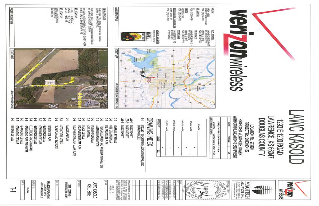
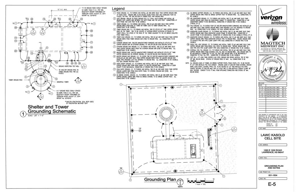
1 PC Staff Report 9/26/2016 CUP Item No. 5-1 PC Staff Report 9/26/2016 ITEM NO. 5 PLANNING COMMISSION REPORT Regular Agenda Public Hearing Item CONDITIONAL USE PERMIT FOR VERIZON WIRELESS; 1287 E 1200 RD (SLD) CUP : Consider a Conditional Use Permit for a new 199 Verizon Wireless communications tower located north of the Westar Substation at 1287 E 1200 Rd. Submitted by PAMCORP LLC for Verizon Wireless LLC on behalf of The Kansas District of the Wesleyan Church Inc, property owner of record. STAFF RECOMMENDATION: Staff recommends approval of the Conditional Use Permit for a communication tower located at 1287 E 1200 Road and forwarding it to the County Commission with a recommendation of approval based on the findings of fact in the body of the staff report. Reason for Request: Verizon Wireless proposes to construct and operate a 190 foot tall self-supporting monopole type communications tower which will be used to provide enhanced wireless voice and data services to its local subscribers. The facility will be unmanned and will be designed to accommodate at least two additional sets of antennas for use by other carriers. Staff comments: A CUP was previously approved by both the Planning Commission and the County Commission. The approval expired after one year when a building permit was not obtained. The County approval is valid for only 12 months. A corresponding Special Use Permit (within the city limits) is valid for a period of 24 months. The overall tower structure is 190. Additional height is added by the placement of a 9 lightning rod on top of the tower structure. Typically towers less than 200 are not required to be lit by FAA standards. ATTACHMENTS 1. Site plan KEY POINTS Application is for a new 190 monopole tower with a 9 lightning rod. Ground equipment includes an equipment shelter building and generator to be located within the shelter building. Property is encumbered by regulatory floodplain. Property is located in the Lawrence Urban Growth Area. This application includes a 100 by 100 development area. Initially only a portion of the site will be developed with a tower and equipment. The future pad sites will require expansion of the enclosure. ASSOCIATED CASES/OTHER ACTION REQUIRED CUP approved by the Planning Commission on 11/17/2014. Approved by the County Commission on 2/10/15. Application expired on 2/10/2016. Board of County Commissioners approval of the Conditional Use. Submission and approval of a local floodplain development permit to Douglas County. Submission and approval of a local building permit to Douglas County. Obtain a Conditional Use Permit from Douglas County. Obtain a driveway permit from the City of Lawrence.

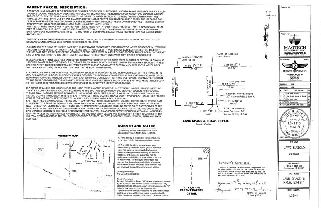
2 PC Staff Report 9/26/2016 CUP Item No. 5-2 PUBLIC COMMENT No communication has been recived. Site Summary: Subject Property: Proposed Buildings: acres 100 x 100 lease area 11 x 25 Pad site for equipment shelter building H frame for equipment 190 monopole with 9 lightning rod Generator located within shelter building Additional pad sites for future carriers VC Figure 1: Existing Zoning GENERAL INFORMATION Current Zoning and Land Use: Surrounding Zoning and Land Use: A (Agricultural) and VC (Valley Channel) Districts. Existing agricultural field. A (Agricultural) and VC (Valley Channel) Districts to the North; existing agricultural field. A (Agricultural) and VC (Valley Channel) Districts to the South; KPL substation. VC (Valley Channel) District to the west. Yankee Tank Creek, riparian area and agricultural field. A (Agricultural) and RM12 (Multi-Dwelling Residential) District to the east. Rural Water District #5 pump station and future Religious Institution and Duplex Residential uses.
 zoning to the east.")
3 PC Staff Report 9/26/2016 CUP Item No. 5-3 I. ZONING AND USES OF PROPERTY NEARBY This property includes county zoning to the north, south and west and urban (City of Lawrence) zoning to the east. The property to the east was annexed in 2009 and has been rezoned multiple times to accommodate future development of the site. The immediate property to the east is undeveloped at this time but has been platted for development. Two properties located in proximity to the subject property are used for utility purposes E 1200 Road, zoned A (Agricultural) District; RWD #5 (to the east) E 1200 Road, zoned A (Agricultural) and VC (Valley Channel) Districts; Westar substation (to the south). Staff Finding The predominate zoning and land use on the west side of E 1200 Road (Kasold Drive) is agricultural. The predominate zoning and land use on the east side of E 1200 Road (Kasold Drive) is currently undeveloped but zoned for future Religious Institution and Duplex Residential uses. II. CHARACTER OF THE AREA This property is located on the southwest fringe of the Lawrence city limits. The property is located between W. 31 st Street (extended) and the South Lawrence Trafficway (SLT)/K-10. This area has an agricultural character with limited development potential because of extensive floodplain in the area. The land area east of Kasold Drive is developing with urban residential uses. The subject property is bounded on the west side by the Yankee Tank Creek. The Westar substation and large overhead transmission lines run parallel to the South Lawrence Trafficway. The Lawrence multi-use path is located along the west side of Kasold Drive and connects W. 31 st Street to the path along the north side of K-10 Highway. The right of way for Kasold Drive/E 1200 Road has been fully annexed into the site along the length of the property and an additional 180 south of W. 32 nd Street. The street/road extends south to an intersection with K-10 Highway. KDOT is Figure 2: Multi-Use Path proceeding with designs to make the intersection a right-in/right-out access to the highway. No other changes are proposed in the immediate area that impact or affect the character of the area. Staff Finding This property is located in a unique area of Lawrence between the existing city limits and the South Lawrence Traffiway/K-10. The property is bounded by Yankee Tank Creek and includes limited development options because of existing floodplain. Area to the east is developing with residential uses.
4 PC Staff Report 9/26/2016 CUP Item No. 5-4 III. SUITABILITY OF SUBJECT PROPERTY FOR THE USES TO WHICH IT HAS BEEN RESTRICTED Applicant s response: Yes This property is currently restricted to uses allowed in the A (Agricultural) and VC (Valley Channel) Districts. These two districts are generally associated with agricultural activities such as farms, truck gardens, nurseries, grazing and similar activities. The A portion of the property allows both residential and non-residential uses. The VC portion of the property is more restrictive regarding land use. The proposed tower will be located on the A zoned portion of the subject property. The proposed request does not change the base zoning district or alter the allowed uses. Section (d) specifically identifies commercial, industrial or agricultural zoning districts as suitable for communication towers. Staff Finding The portion of the subject property zoned A (Agricultural) District is a suitable district for the proposed use. The base zoning district is not altered by this request. A communication tower is an allowed use in the A (Agricultural) District subject to a Conditional Use Permit. IV. LENGTH OF TIME SUBJECT PROPERTY HAS REMAINED VACANT AS ZONED The property is currently vacant with the exception of two silos located in the southeast corner of the site. The zoning has remained unchanged since Previously the applicant sought and obtained approval for construction of a communication tower. The approval expired resulting in the applicant seeking new approval for the same project. Staff Finding The property is essentially vacant with the exception of two silos as described above. The zoning has remained unchanged since The previously approved CUP expired. V. EXTENT TO WHICH REMOVAL OF RESTRICTIONS WILL DETRIMENTALLY AFFECT NEARBY PROPERTY Applicant s Response: No Section of the County Zoning Regulations recognize that.certain uses may be desirable when located in the community, but that these uses may be incompatible with other uses permitted in a district when found to be in the interest of the public health, safety, morals and general welfare of the community may be permitted, except as otherwise specified in any district from which they are prohibited. Communication towers are specifically recommended to be located in commercial, industrial or agricultural zoning districts. The location of the tower is situated so that it has a visual connection to other existing utility uses in the immediate area and to have the least adverse impact on the regulatory floodplain. Staff Finding Development potential in the area is limited by the presence of extensive regulatory floodplain. At this time the area to the north and east is undeveloped. Any future development will occur with knowledge of this improvement, if approved.
5 PC Staff Report 9/26/2016 CUP Item No. 5-5 VI. RELATIVE GAIN TO THE PUBLIC HEALTH, SAFETY AND WELFARE BY THE DESTRUCTION OF THE VALUE OF THE PETITIONER S PROPERTY AS COMPARED TO THE HARDSHIP IMPOSED UPON THE INDIVIDUAL LANDOWNERS Approval of the request expands the structural network of towers and structures that are capable of supporting communication equipment. The proposed request facilitates cellular communications and wireless data use within the community. The proposed equipment does not conflict with existing emergency communication equipment. The majority of the property will remain viable for existing land uses and uses permitted within the A (agricultural) and VC (Valley Channel) Districts. Staff Finding The benefit to the public is improved cellular communication and wireless data capacity within the Verizon network. Additionally, the structure provides an opportunity for other carriers to co-locate in the future. If denied, the property can continue to be used for current land uses and those uses allowed per the existing zoning of the property. VII. CONFORMANCE WITH THE COMPREHENSIVE PLAN The subject property is located within an the Lawrence Urban Growth Area and is immediately adjacent to the City Limits. Chapter 10; Community Facilities of Horizon 2020 addresses public utilities. Key strategies (Page 10-10) primarily address municipal unities such as water and wastewater planning. One strategy states: The visual appearance of utility improvements will be addressed to ensure compatibility with existing and planned land use areas. The plan specifically addressed electric and telephone services and encourages this infrastructure to be placed underground in conjunction with new development where feasible. Communication towers support the wireless industry and accommodate the reduction of hardwire infrastructure. However, it should not be interpreted that wireless communication will replace hardwire needs in the community. The plan recognizes that telephone and electric utilities have a strong visual presence in the unincorporated Douglas County Landscape. Large transmission lines and easements should be coordinated throughout the community to minimize visual and environmental impacts. The Comprehensive Plan does not explicitly address communication towers. Staff Finding The comprehensive plan does not provide any specific land use recommendations regarding communication towers. A Conditional Use Permit can be used to allow specific nonresidential uses subject to approval of a site plan. This tool allows proportional development in harmony with the surrounding area. The proposed request is consistent with the Comprehensive Plan. STAFF REVIEW In addition to typical site plan design standards, communication towers must address specific requirements of section of the County Zoning Regulations. As discussed above, the proposed use is located in an appropriate zoning district.
6 PC Staff Report 9/26/2016 CUP Item No. 5-6 New communication towers require design that shall accommodate at least three two-way antennas for every 150 of tower height or co-location space. The proposed tower includes three co-location spaces in addition to the Verizon equipment space for a total of up to four carriers on this tower. Although, changes in federal law may negate this design criterion. Additional review of the existing County communication tower regulations is needed to align the regulations with the current laws. Setback The setback of the communication tower is required, per section (d), to be at least equal to the height of the tower to the nearest property line measured from the center of the tower. The east property line is the nearest property line to the proposed improvements. The tower setback may be reduced when documentation from a registered engineer is submitted certifying the fall zone of the tower in the event of a failure. Evaluation of the required structural documentation will continue to be reviewed with the submission of a building permit to the County Zoning and Codes Office. The proposed setback is shown to be 118 from the east property line to the center of the tower. The tower and ground equipment will be located in a 100 by 100 enclosure area located approximately 90 from the east property line. The initial enclosure area will be 50 by 50 to accommodate expansion of the base station as additionally carriers co-locate on the tower. The proposed equipment shelter is located approximately 100 from the east property line. The site plan shows pad sites within the enclosure to accommodate future carriers located on the north and west sides of the tower. The initial 50 by 50 fenced enclosure would need to be expanded to accommodate future co-location applications. Lighting Lighting is not proposed with this application for the communication tower. The tower will need to meet any applicable FAA requirements. Generally, towers less than 200 are not required to be lit. ground equipment will have lighting on front and rear sides of the building. Lighting must be shielded and directed down. Access, Circulation, and Off Street Parking Access to this site is from E 1200 Road/Kasold Drive. This segment of E 1200 Road is completely within the city limits. The applicant will be required to seek a driveway permit for access to the tower site from the City of Lawrence. The drive will provide maintenance access to the tower enclosure. This use does not require off-street parking. The design of the site provides adequate vehicular access and turnaround for maintenance activity on the site. The site plan shows a city standard driveway apron to the site. Landscaping/Buffering This site will not be irrigated and will not be staffed. The survival of vegetation used for screening is usually unsuccessful especially in a rural application. Per previous discussions with the applicant street trees were recommended for this site. The site plan shows five street trees planted along the west side of the multi-use path. Other Prior to construction of the tower the applicant will be required to obtain a Conditional Use Permit, issued by the County Zoning and Codes office as well as applicable building and floodplain development permits.
7 PC Staff Report 9/26/2016 CUP Item No. 5-7 Recent changes to federal laws allow some future modifications to approved and existing communication towers, base stations, co-location equipment and other features. The full scope of these changes has not been assessed by staff. Changes can include expanding the tower by up to an additional 20 and increasing the base station (enclosure area) by up to 10%. Conclusion The proposed application meets the required documentation requirements of the County Zoning Regulations. Staff recommends minor changes to the site plan to faciliate the project compatibility with some City design standards since this site is located on the boundary of the existing city limits.
8
9
10
11
12
13
14
15
16
17
18
19
20
21
22
23
24
25
26
27
28
29
30
31
32 OS RM12D UR 3033 RM E 1200 Rd Havrone Way W 31st St RS Approximate location of tower A Kasold Dr 3351 k RM12 W 32nd St VC 1287 RM12-FP 3300 OS-FP OP 10 State Highway 10 E 1200 Rd CUP : Conditional Use Permit for a New 190' Communication Tower for Verizon Wireless Located North of Westar Substation at 1287 E 1200 Road µ Lawrence-Douglas County Planning Office September 2016 Subject Properties
PLANNING COMMISSION REPORT Regular Agenda Public Hearing Item
 CUP-15-00474 Item No. 5-1 PC Staff Report 11/16/15 ITEM NO. 5 PLANNING COMMISSION REPORT Regular Agenda Public Hearing Item CONDITIONAL USE PERMIT FOR PUBLIC WHOLESALE WATER SUPPLY DISTRICT NO. 25; E 1300
PLANNING COMMISSION REPORT Regular Agenda - Public Hearing Item
 Z-15-00469 Item No. 6A- 1 PLANNING COMMISSION REPORT Regular Agenda - Public Hearing Item PC Staff Report 11/16/15 ITEM NO. 6A GPI, RM12, & RS40 TO RM12; 14.756 ACRES; 5200 & 5300 CLINTON PKWY (SLD) Z-15-00469:
Allow continued use of existing grass runway for personal use by landowner.
 CUP-13-00193 Item No. 4-1 PLANNING COMMISSION REPORT Regular Agenda PC Staff Report 7/22/13 ITEM NO. 4: CONDITIONAL USE PERMIT; PRIVATE LANDING STRIP; 2215 N 500 (MKM) CUP-13-00193: Consider a Conditional
PLANNING COMMISSION REPORT Regular Agenda Public Hearing Item
 PC Staff Report 11/12/12 Item No. 2B- 1 PLANNING COMMISSION REPORT Regular Agenda Public Hearing Item ITEM NO. 2B: A TO GPI; 110 ACRES; E OF K-10 & N OF W 6 TH ST (MKM) : Consider a request to rezone approximately
PC Staff Report 11/18/2013 Z Item No. 1-1
 Z-13-00401 Item No. 1-1 PLANNING COMMISSION REPORT Regular Agenda - Public Hearing Item PC Staff Report 11/18/2013 ITEM NO. 1: Z-13-00401 IG (General Industrial) District TO CS (Strip Commercial) District;
PLANNING COMMISSION REPORT Regular Agenda Public Hearing Item
 PC Staff Report 10/21/2013 Item No. 3B - 1 PC Staff Report 10/21/2013 ITEM NO. 3B: PLANNING COMMISSION REPORT Regular Agenda Public Hearing Item A TO CR- FP; 8.4 ACRES; 1900 W. 31 st STREET (SLD) : Consider
PLANNING COMMISSION REPORT REGULAR AGENDA
 PP-4-4-11 Item No. 9-1 PLANNING COMMISSION REPORT REGULAR AGENDA PC Staff Report 06/22/11 ITEM NO 9: PRELIMINARY PLAT; KASOLD WATER TOWER ADDITION; SE OF TAM O SHANTER & KASOLD DR (MKM) PP-4-4-11: Consider
PLANNING COMMISSION REPORT Regular Agenda Public Hearing Item PRD TO RM15; ACRES; 2101 EXCHANGE CT (KES)
") PC Staff Report 7/22/15 Z-14-00515 Item No. 3-1 PLANNING COMMISSION REPORT Regular Agenda Public Hearing Item PC Staff Report 7/22/15 ITEM NO. 3 PRD TO RM15; 9.818 ACRES; 2101 EXCHANGE CT (KES) Z-14-00515:
PC Staff Report 7/22/15 Z-14-00515 Item No. 3-1 PLANNING COMMISSION REPORT Regular Agenda Public Hearing Item PC Staff Report 7/22/15 ITEM NO. 3 PRD TO RM15; 9.818 ACRES; 2101 EXCHANGE CT (KES) Z-14-00515:
Planning Department Oconee County, Georgia
 Planning Department Oconee County, Georgia STAFF REPORT REZONE CASE #: 6985 DATE: October 31, 2016 STAFF REPORT BY: Andrew C. Stern, Planner APPLICANT NAME: Williams & Associates, Land Planners PC PROPERTY
RESOLUTION PC NOW THEREFORE, the Planning Commission of the City of Duarte resolves as follows:
 RESOLUTION PC 18-09 A RESOLUTION OF THE PLANNING COMMISSION OF THE CITY OF DUARTE APPROVING CONDITIONAL USE PERMIT 14-02, FOR THE USE AND OPERATION OF A WIRELESS COMMUNICATION FACILITY FOR VERIZON WIRELESS,
PLANNING COMMISSION REPORT Regular Agenda -Public Hearing Item
 PDP-13-00518 Item No. 3B- 1 PLANNING COMMISSION REPORT Regular Agenda -Public Hearing Item PC Staff Report 2/24/14 ITEM NO. 3B PRELIMINARY DEVELOPMENT PLAN FOR HERE @ KANSAS; 1101 INDIANA ST (SLD) PDP-13-00518:
PLANNING COMMISSION REPORT Regular Agenda - Public Hearing Item
 Z-11-25-09; Z-11-26-09; Z-11-28-09 Item No. 2-1 PC Staff Report 3/28/11 PLANNING COMMISSION REPORT Regular Agenda - Public Hearing Item ITEM NO. 2A RM32 TO MU;.19 ACRES; 1340 TENNESSEE ST (MJL) Z-1-1-11:
PLANNING COMMISSION REPORT Regular Agenda Public Hearing Item
 PC Staff Report 6/20/16 Item No. 4-1 PLANNING COMMISSION REPORT Regular Agenda Public Hearing Item PC Staff Report 06/20/16 ITEM NO. 4: IG to CS 1.56 ACRES; 706 E 23 RD STREET (MKM) : Consider a request
New Cingular Wireless Telecommunication Tower at County Road 48, Milner Conditional Use Permit
 New Cingular Wireless Telecommunication Tower at 39415 County Road 48, Milner ACTIVITY #: Conditional Use Permit PP2012-023 HEARING DATES: Planning Commission (PC): August 16, 2012 at 6:00pm PETITIONER:
PLANNING COMMISSION REPORT Regular Agenda - Public Hearing Item
 Z-14-00056 Item No. 1-1 PLANNING COMMISSION REPORT Regular Agenda - Public Hearing Item PC Staff Report 4/21/2014 ITEM NO. 1: RSO TO CN1;.126 ACRES; 512 & 514 LOCUST ST (DRG) Z-14-00056: Consider a request
PLANNING COMMISSION REPORT Regular Agenda Public Hearing Item
 PC Staff Report 06/22/2015 Item No. 3A - 1 PC Staff Report 6/22/2015 ITEM NO. 3A: PLANNING COMMISSION REPORT Regular Agenda Public Hearing Item RSO TO CN2; 10 ACRES; 4300 W 24 th Place (SLD) : Consider
PLANNING COMMISSION REPORT Regular Agenda Public Hearing Item
 PC Staff Report 2/22/16 Z-15-00640 Item No. 1-1 PLANNING COMMISSION REPORT Regular Agenda Public Hearing Item PC Staff Report 2/22/16 ITEM NO. 1 Villa 26 Apartments Rezoning from (Commercial Strip) to
Request Conditional Use Permit (Communication Tower) Staff Recommendation Approval. Staff Planner Emily Bazemore
 Staff Recommendation Approval. Staff Planner Emily Bazemore") Applicant Property Owner Columbia Club of Virginia Beach Public Hearing July 11, 2018 City Council Election District Beach Agenda Item 5 Request Conditional Use Permit (Communication Tower) Staff Recommendation
Applicant Property Owner Columbia Club of Virginia Beach Public Hearing July 11, 2018 City Council Election District Beach Agenda Item 5 Request Conditional Use Permit (Communication Tower) Staff Recommendation
PLANNING COMMISSION REPORT Regular Agenda - Public Hearing Item
 Z-12-29, 30, 32, 33, 34, 35, 36-11 to Item No. 5A 5G- 1 PLANNING COMMISSION REPORT Regular Agenda - Public Hearing Item PC Staff Report 02/27/2012 ITEM NO. 5A-5G Z-12-29, 30, 32, 33, 34, 35, 36-11 from
PLANNING COMMISSION REPORT Regular Agenda Public Hearing Item
 PC Staff Report 06/21/10 Item No. 4-1 PLANNING COMMISSION REPORT Regular Agenda Public Hearing Item ITEM NO. 4: PD-[TANGER PCD-1] TO CS; 1025 N. 3 rd STREET (SLD) : Consider a request to rezone approximately
2. The AT&T WCF shall consist of a stealth design (faux saguaro cactus) with a maximum height of 30 feet above adjacent grade;
 with a maximum height of 30 feet above adjacent grade;") AGENDA ITEM # DATE: October 24, 2011 COAC NUMBER: 11-4698 CITY OF GOODYEAR CITY COUNCIL ACTION FORM SUBJECT: Special Use to allow the installation of a proposed AT&T Wireless Communication Facility to
AGENDA ITEM # DATE: October 24, 2011 COAC NUMBER: 11-4698 CITY OF GOODYEAR CITY COUNCIL ACTION FORM SUBJECT: Special Use to allow the installation of a proposed AT&T Wireless Communication Facility to
Subdivision of existing two lots into three lots.
 PP-15-00189 Item No. 4-1 PC Staff Report 06/22/2015 PLANNING COMMISSION REPORT NON PUBLIC HEARING ITEM PUBLIC HEARING ON THE VARIANCE ONLY ITEM NO 4: PRELIMINARY PLAT FOR DEERFIELD WOODS SUBDIVISION NO.
REPRESENTATIVE: Centerline Solutions Table Mountain Parkway Golden, CO 80403
 COMMISSIONERS: DARRYL GLENN (PRESIDENT) MARK WALLER (PRESIDENT PRO TEMPORE) STAN VANDERWERF LONGINOS GONZALEZ PEGGY LITTLETON PLANNING AND COMMUNITY DEVELOPMENT DEPARTMENT CRAIG DOSSEY, EXECUTIVE DIRECTOR
Planning and Zoning Staff Report Vallivue School District - PH
 Hearing Date: April 19, 2018 Planning and Zoning Staff Report - PH2018-16 Development Services Department Applicant: Nate Bondelid Owner: Staff: Dan Lister, Planner II (208) 455-5959 dlister@canyonco.org
PLANNING & DEVELOPMENT
 PLANNING & DEVELOPMENT STAFF REPORT Rezoning PETITION: APPLICANT: PROPERTY OWNER: TYPE OF REQUEST: SIZE OF TRACT: LOCATION: (#17-22) Rezone from A-PUD (Agri-Business Planned Unit Development) to A-PUD
This is a conditional use permit request to establish a commercial wind energy conversion system.
 Public Works 600 Scott Boulevard South Hutchinson, Kansas 67505 620-694-2976 Road & Bridge Planning & Zoning Noxious Weed Utilities Date: March 28, 2019 To: From: Reno County Planning Commission Russ Ewy,
The minutes of the October 7, 201 4, meeting were approved on a m otion by Martin, seconded by Woleslagel, passed unanimously.
 1 MINUTES CITY PLANNING COMMISSION TUESDAY, OCTOBER 21, 2014 5:00 p.m. CITY COUNCIL CHAMBERS 125 EAST AVENUE B 1. The Planning Commission meeting was called to order with the following members present:
Medical Marijuana Special Exception Use Information
 Medical Marijuana Special Exception Use Information The Special Exception Use information below is a modified version of the Unified Development Code. It clarifies the current section 5:104 Special Exceptions
O-I (Office-Institutional) and AG-1(Agricultural)
 and AG-1(Agricultural)") PROPERTY INFORMATION ADDRESS 3503 and 3505 Bethany Bend DISTRICT, LAND LOTS 2/1 973 and 974 OVERLAY DISTRICT State Route 9 PETITION NUMBERS EXISTING ZONING O-I (Office-Institutional) and AG-1(Agricultural)
PROPERTY INFORMATION ADDRESS 3503 and 3505 Bethany Bend DISTRICT, LAND LOTS 2/1 973 and 974 OVERLAY DISTRICT State Route 9 PETITION NUMBERS EXISTING ZONING O-I (Office-Institutional) and AG-1(Agricultural)
Planning and Zoning Staff Report Maverick Towers Van Wassenhove, PH
 Planning and Zoning Staff Report Maverick Towers Van Wassenhove, PH2018-17 Hearing Date: April 19, 2018 Development Services Department Applicant: Maverick Towers - Nadine Bostwick Owner: Paul Van Wassenhove
PLANNING COMMISSION REPORT Regular Agenda Non Public Hearing Item
 PC Staff Report 3/23/15 FDP-14-00551 Item No. 2-1 PLANNING COMMISSION REPORT Regular Agenda Non Public Hearing Item PC Staff Report 3/23/15 ITEM NO. 2: FINAL DEVELOPMENT PLAN FOR HUTTON FARMS WEST PHASE
PLANNING AND DEVELOPMENT DEPARTMENT STAFF REPORT SAVOY DRIVE AREA ZONING MAP AMENDMENT II
 PLANNING AND DEVELOPMENT DEPARTMENT STAFF REPORT Meeting Date: March 14, 2019 Item #: PZ2019-429 SAVOY DRIVE AREA ZONING MAP AMENDMENT II Project Name: Savoy Drive Area Zoning Map Amendment II Site Addresses:
Memorandum City of Lawrence Planning Department
 Memorandum City of Lawrence Planning Department TO: FROM: CC: Lawrence Douglas County Planning Commission Sandra Day, AICP, Planning Staff Applicant Date: January 14, 2013 RE: Item No. 3: Langston Heights
b) Tangerine Corridor Overlay District 1) Tangerine Corridor District Regulations
 Tangerine Corridor Overlay District 1) Tangerine Corridor District Regulations") Attachment 1 Tangerine Road Corridor Overlay District Section 27.10.D.3.f.vi.b Initiation of Code Amendment September 2, 2014, Planning and Zoning Commission b) Tangerine Corridor Overlay District 1) Tangerine
Attachment 1 Tangerine Road Corridor Overlay District Section 27.10.D.3.f.vi.b Initiation of Code Amendment September 2, 2014, Planning and Zoning Commission b) Tangerine Corridor Overlay District 1) Tangerine
Urban Planning and Land Use
 Urban Planning and Land Use 701 North 7 th Street, Room 423 Phone: (913) 573-5750 Kansas City, Kansas 66101 Fax: (913) 573-5796 Email: planninginfo@wycokck.org www.wycokck.org/planning To: From: City Planning
Chapter 100 Planned Unit Development in Corvallis Urban Fringe
 100.100 Scope and Purpose. Chapter 100 Planned Unit Development in Corvallis Urban Fringe (1) All applications for land divisions in the Urban Residential (UR) and Flood Plain Agriculture (FPA) zones within
ARTICLE 23 CONDOMINIUM STANDARDS
 ARTICLE 23 CONDOMINIUM STANDARDS Section 23.01 Intent. The intent of this Article is to provide regulatory standards for condominiums and site condominiums similar to those required for projects developed
All items include discussion and possible action to approve, modify, deny, or continue unless marked otherwise.
 Storey County Planning Commission Meeting Agenda Thursday, October 6, 2016 6:00 p.m. Storey County Courthouse, District Courtroom 26 South B Street, Virginia City, Nevada Larry Prater Chairman Virgil Bucchianeri
Planning Department Oconee County, Georgia STAFF REPORT
 Planning Department Oconee County, Georgia STAFF REPORT REZONE CASE #: 7332 DATE: November 28, 2017 STAFF REPORT BY: Gabriel Quintas, Planner APPLICANT NAME: Smith Planning Group PROPERTY OWNER: John Hadden
DESOTO COUNTY PLANNING AND ZONING DEPARTMENT STAFF REPORT
 DESOTO COUNTY PLANNING AND ZONING DEPARTMENT STAFF REPORT REQUEST: PROPERTY OWNER: APPLICANT: AGENT: SE 2014-02 Felix & Maria Zapata Felix & Maria Zapata Same N/A PROPERTY: 35-38-24-0116-0010-0090 TOTAL
STAFF REPORT #
 STAFF REPORT #15-4000-0001 A Conditional Use PLANNING COMMISSION MEETING DATE: March 19, 2015 1. APPLICATION: A public hearing regarding a request for a conditional use permit for the installation of a
PLANNING COMMISSION REPORT Regular Agenda Public Hearing Item. IG TO IL;.972 ACRES; 1021 E 31st (KES)
") PC Staff Report 11/16/15 Z-15-00471 Item No. 7-1 PLANNING COMMISSION REPORT Regular Agenda Public Hearing Item PC Staff Report 11/16/15 ITEM NO. 7 IG TO IL;.972 ACRES; 1021 E 31st (KES) Z-15-00471: Consider
PC Staff Report 11/16/15 Z-15-00471 Item No. 7-1 PLANNING COMMISSION REPORT Regular Agenda Public Hearing Item PC Staff Report 11/16/15 ITEM NO. 7 IG TO IL;.972 ACRES; 1021 E 31st (KES) Z-15-00471: Consider
ARTICLE 15 - PLANNED UNIT DEVELOPMENT
 Section 15.1 - Intent. ARTICLE 15 - PLANNED UNIT DEVELOPMENT A PUD, or Planned Unit Development, is not a District per se, but rather a set of standards that may be applied to a development type. The Planned
ARTICLE 14 PLANNED UNIT DEVELOPMENT (PUD) DISTRICT
 DISTRICT") ARTICLE 14 PLANNED UNIT DEVELOPMENT (PUD) DISTRICT Section 14.01 Intent. It is the intent of this Article to allow the use of the planned unit development (PUD) process, as authorized by the Michigan Zoning
ARTICLE 14 PLANNED UNIT DEVELOPMENT (PUD) DISTRICT Section 14.01 Intent. It is the intent of this Article to allow the use of the planned unit development (PUD) process, as authorized by the Michigan Zoning
AGENDA. a. Carol Crews Special Exception Hair Salon (Continued from February) b. James Barber Special Exception Horse
 b. James Barber Special Exception Horse") Baker County Land Planning Agency (LPA) Thursday, April 23, 2015 Baker County Administration Building 55 North Third Street Macclenny, FL 32063 (904) 259-3354 AGENDA 5:OO P.M. LDR Mining Workshop A. Draft
Baker County Land Planning Agency (LPA) Thursday, April 23, 2015 Baker County Administration Building 55 North Third Street Macclenny, FL 32063 (904) 259-3354 AGENDA 5:OO P.M. LDR Mining Workshop A. Draft
Telecommunications Development Permit Application Package
 Telecommunications Development Permit Application Package POLICY POL#308 Title: Policy Guidelines to Evaluate Commercial Communications Facilities Legal References: Radio Communication Act Municipal Government
Napa County Planning Commission Board Agenda Letter
 Agenda Date: 2/7/2018 Agenda Placement: 8C Napa County Planning Commission Board Agenda Letter TO: FROM: Napa County Planning Commission Charlene Gallina for David Morrison - Director Planning, Building
SUBDIVISION, PLANNED UNIT DEVELOPMENT, & PLANNING APPROVAL STAFF REPORT Date: February 1, 2007
 SUBDIVISION, PLANNED UNIT DEVELOPMENT, & PLANNING APPROVAL STAFF REPORT Date: February 1, 2007 DEVELOPMENT NAME SUBDIVISION NAME Pala Verde Mobile Home Park Subdivision Pala Verde Mobile Home Park Subdivision
ITEM NO(S): B.1 B.3 STAFF: SHARON ROBINSON FILE NO(S): CPC CU QUASI-JUDICIAL CPC UV QUASI_JUDICIAL CPC NV QUASI-JUDICIAL
: B.1 B.3 STAFF: SHARON ROBINSON FILE NO(S): CPC CU QUASI-JUDICIAL CPC UV QUASI_JUDICIAL CPC NV QUASI-JUDICIAL") Page 16 CITY PLANNING COMMISSION ITEM NO(S): B.1 B.3 STAFF: SHARON ROBINSON FILE NO(S): CPC CU 09-00042 QUASI-JUDICIAL CPC UV 09-00130 QUASI_JUDICIAL CPC NV 09-00128 QUASI-JUDICIAL PROJECT: APPLICANT:
Page 16 CITY PLANNING COMMISSION ITEM NO(S): B.1 B.3 STAFF: SHARON ROBINSON FILE NO(S): CPC CU 09-00042 QUASI-JUDICIAL CPC UV 09-00130 QUASI_JUDICIAL CPC NV 09-00128 QUASI-JUDICIAL PROJECT: APPLICANT:
LINN COUNTY BOARD OF ADJUSTMENT. Jean Oxley Public Service Center nd Street SW, Cedar Rapids, Iowa. MINUTES Wednesday, March 28, 2018
 LINN COUNTY BOARD OF ADJUSTMENT Jean Oxley Public Service Center 935 2 nd Street SW, Cedar Rapids, Iowa MINUTES Wednesday, I. QUORUM DETERMINE D: The Linn County Board of Adjustment meeting was called
MONTEREY COUNTY PLANNING COMMISSION
 MONTEREY COUNTY PLANNING COMMISSION Meeting: June 11, 2003 @ 9:30 AM Agenda Item: D2 Project Description: Use Permit (Associated Tagline/Sprint #PLN000669) for the construction of a 50 Ft. monopole with
PLANNING COMMISSION REPORT REGULAR AGENDA --NON-PUBLIC HEARING ITEM:
 PP-6-00068 Item No. 5B - PLNNING COMMISSION REPORT REGULR GEND --NON-PUBLIC HERING ITEM: PC Staff Report 04/25/6 ITEM NO. 5B: PRELIMINRY PLT FOR KING S RECYCLE CENTER; N 300 RD & E 750 RD (MKM) PP-6-00068:
Urban Planning and Land Use
 Urban Planning and Land Use 701 North 7 th Street, Room 423 Phone: (913) 573-5750 Kansas City, Kansas 66101 Fax: (913) 573-5796 Email: planninginfo@wycokck.org www.wycokck.org/planning To: From: City Planning
Urban Planning and Land Use
 Urban Planning and Land Use 701 North 7 th Street, Room 423 Phone: (913) 573-5750 Kansas City, Kansas 66101 Fax: (913) 573-5796 Email: planninginfo@wycokck.org www.wycokck.org/planning To: From: City Planning
SPECIAL USE PERMIT EXTRA-TERRITORIAL ZONING COMMISSION
 SPECIAL USE PERMIT EXTRA-TERRITORIAL ZONING COMMISSION DOÑA ANA COUNTY COMMUNITY DEVELOPMENT DEPARTMENT Doña Ana County Government Complex 845 N. Motel Blvd., Las Cruces, New Mexico 88007 Office: (575)
AGENDA PLANNING COMMISSION Tuesday, April 18, :00 PM City Council Chambers 125 East Avenue B, Hutchinson, Kansas
 AGENDA PLANNING COMMISSION Tuesday, April 18, 2017 5:00 PM City Council Chambers 125 East Avenue B, Hutchinson, Kansas 1. ROLL CALL Macklin Woleslagel Bisbee (Chair) Hamilton Peirce Vacant Carr Hornbeck
Metropolitan Planning Commission. DATE: April 5, 2016
 TO: FROM: Metropolitan Planning Commission MPC Staff DATE: April 5, 2016 SUBJECT: Petition of Nine Line Inc. Robert McCorkle, Agent PIN: 2-1034-01-002 380.5 Acres Aldermanic District: 5 (Shabazz) County
TITLE 33 REGULATION OF WIRELESS TELECOMMUNICATIONS FACILITIES
 CITY OF STURGIS ORDINANCES TITLE 33-1 TITLE 33 REGULATION OF WIRELESS TELECOMMUNICATIONS FACILITIES (Title 33 established effective 8/4/07, Ordinance 2007-17) Chapters: 33.01: General Provisions 33.02:
Urban Planning and Land Use
 Urban Planning and Land Use 701 North 7 th Street, Room 423 Phone: (913) 573-5750 Kansas City, Kansas 66101 Fax: (913) 573-5796 Email: planninginfo@wycokck.org www.wycokck.org/planning To: From: City Planning
SUBDIVISION REGULATIONS
 SUBDIVISION REGULATIONS for Lawrence and the Unincorporated Areas of Douglas County, KS Regulations Governing Land Divisions in the City of Lawrence and the Unincorporated Areas of Douglas County, Kansas
CITY OF FORT COLLINS NATURAL AREAS AND CONSERVED LANDS EASEMENT POLICY
 CITY OF FORT COLLINS NATURAL AREAS AND CONSERVED LANDS EASEMENT POLICY Adopted January 3, 2012 PURPOSE: The purpose of the policy statement is to clarify the policies and procedures of the City of Fort
DEVELOPMENT DEPARTMENT STAFF REPORT STAFF REPORT MCDONALD S ZONING MAP AMENDMENT AND CONCURRENT VARIANCES
 DEVELOPMENT DEPARTMENT STAFF REPORT Meeting Date: October 12, 2017 Item #: _PZ2017-172_ STAFF REPORT MCDONALD S ZONING MAP AMENDMENT AND CONCURRENT VARIANCES Request: Rezone property from MU-BC to CC,
Urban Planning and Land Use
 Urban Planning and Land Use 701 North 7 th Street, Room 423 Phone: (913) 573-5750 Kansas City, Kansas 66101 Fax: (913) 573-5796 Email: planninginfo@wycokck.org www.wycokck.org/planning To: From: City Planning
SUBDIVISION REGULATIONS for Lawrence and the Unincorporated Areas of Douglas County, KS
 SUBDIVISION REGULATIONS for Lawrence and the Unincorporated Areas of Douglas County, KS December 19, 2006 Edition Amended: 09/11/07; 12/04/07; 03/25/08; 09/10/08 Amended: January 6, 2009 Article 8 Subdivision
Special Land Use. SLU Application & Review Standards
 review and approval is needed for certain uses of property that have the potential to impact adjacent properties and the neighborhood. The application and review procedure is intended to ensure that the
TOWN OF RUTLAND Ordinance No. 12.5
 TOWN OF RUTLAND Ordinance No. 12.5 AN ORDINANCE RELATING TO CHANGES TO ZONING DISTRICT BOUNDARIES AND CONDITIONAL USE PERMITS REQUESTED TO ALLOW THE CONSTRUCTION AND OPERATION OF COMMUNICATION TOWERS The
ZONING ORDINANCE: OPEN SPACE COMMUNITY. Hamburg Township, MI
 ZONING ORDINANCE: OPEN SPACE COMMUNITY Hamburg Township, MI ARTICLE 14.00 OPEN SPACE COMMUNITY (Adopted 1/16/92) Section 14.1. Intent It is the intent of this Article to offer an alternative to traditional
8 March 12, 2014 Public Hearing
 8 March 12, 2014 Public Hearing APPLICANT: NEW CINGULAR WIRELESS PCS, L.L.C. PROPERTY OWNER: CYPRESS POINT ENTERPRISES, INC. STAFF PLANNER: Ray Odom REQUEST: A. Conditional Change of Zoning (from PD-H2
Urban Planning and Land Use
 Urban Planning and Land Use 701 North 7th Street, Room 423 Kansas City, Kansas 66101 Email: planninginfo@wycokck.org Phone: (913) 573-5750 Fax: (913) 573-5796 www.wycokck.org/planning To: City Planning
Urban Planning and Land Use
 Urban Planning and Land Use 701 North 7 th Street, Room 423 Phone: (913) 573-5750 Kansas City, Kansas 66101 Fax: (913) 573-5796 Email: planninginfo@wycokck.org www.wycokck.org/planning To: From: City Planning
LAND USE AND ZONING OVERVIEW
 OVERVIEW OF PLANNING POLICIES LAND USE AND ZONING OVERVIEW The Minneapolis Plan for Sustainable Growth and Other Adopted Plans Community Planning and Economic Development Development Services Division
ARTICLE VII. NONCONFORMITIES. Section 700. Purpose.
 ARTICLE VII. NONCONFORMITIES. Section 700. Purpose. The purpose of this chapter is to regulate and limit the development and continued existence of legal uses, structures, lots, and signs established either
CHARTER TOWNSHIP OF VAN BUREN PLANNING COMMISSION JANUARY 10, 2018 MINUTES
 CHARTER TOWNSHIP OF VAN BUREN PLANNING COMMISSION JANUARY 10, 2018 MINUTES Chairperson Thompson called the meeting to order at 7:30 p.m. ROLL CALL: Present: Kelley, Atchinson, Budd, Jahr, Franzoi and Thompson.
ARTICLE 8: SPECIAL LAND USES
 ARTICLE 8: SPECIAL LAND USES Section 8.0 - Purpose Special Land Use permits are required for proposed activities which are essentially compatible with other uses, or activities permitted in a zoning district,
DEPARTMENT OF COMMUNITY DEVELOPMENT SERVICES. Planning Division. m e m o r a n d u m
 DEPARTMENT OF UNITY DEVELOPMENT SERVICES Planning Division m e m o r a n d u m TO: FROM: The Urbana Zoning Board of Appeals Marcus Ricci, Planner II DATE: August 11, 2017 SUBJECT: ZBA Case 2017-C-01: a
TOWN OF WATERVILLE VALLEY NEW HAMPSHIRE SITE PLAN REVIEW REGULATIONS
 TOWN OF WATERVILLE VALLEY NEW HAMPSHIRE Effective date March 17, 1981 Revised March 16, 1982 Revised March 13, 1986 Revised March 10, 1987 Revised March 14, 2013 Revised March 8, 2016 TOWN OF WATERVILLE
CHAPTER 2 GENERAL PROVISIONS
 CHAPTER 2 GENERAL PROVISIONS 200 ZONING DISTRICTS ESTABLISHED 201 SUPPLEMENTAL DISTRICTS ESTABLISHED 202 OFFICIAL ZONING MAP ESTABLISHED 203 DISTRICT BOUNDARY DESCRIPTION and INTERPRETATION 204 LIMITATION
Request Conditional Use Permit (Bulk Storage Yard) Staff Recommendation Approval. Staff Planner Robert Davis
 Staff Recommendation Approval. Staff Planner Robert Davis") Applicant Property Owner Glaser, LLC Public Hearing March 14, 2018 City Council Election District Rose Hall Agenda Item 5 Request Conditional Use Permit (Bulk Storage Yard) Staff Recommendation Approval
Applicant Property Owner Glaser, LLC Public Hearing March 14, 2018 City Council Election District Rose Hall Agenda Item 5 Request Conditional Use Permit (Bulk Storage Yard) Staff Recommendation Approval
Staff Recommendation Approval. Staff Planner Robert Davis
 Applicant Property Owner Reed Enterprises, Inc. Public Hearing November 8, 2017 City Council Election District Princess Anne Agenda Item D1 Request Conditional Use Permit (Bulk Storage Yard) Modification
DEVELOPMENT DEPARTMENT STAFF REPORT STAFF REPORT PUD/DCI BAINBRIDGE MIXED-USE DEVELOPMENT
 DEVELOPMENT DEPARTMENT STAFF REPORT Meeting Date: October 12, 2017 Item #: _PZ-2017-170_ STAFF REPORT PUD/DCI BAINBRIDGE MIXED-USE DEVELOPMENT Request: Project Name: Planned Unit Development (PUD)/ Development
4.2 LAND USE INTRODUCTION
 4.2 LAND USE INTRODUCTION This section of the EIR addresses potential impacts from the Fresno County General Plan Update on land use in two general areas: land use compatibility and plan consistency. Under
T-MOBILE DAVID WILKINS MESSINA & HARRIS, INC.
 APPLICATION NUMBER 5368 A REQUEST FOR HEIGHT, SETBACK, AND BUFFER SEPARATION VARIANCES TO ALLOW THE CONSTRUCTION OF A 70 MONOPOLE TELECOMMUNICATIONS TOWER, SETBACK 6.89 FROM A LEASE PARCEL LINE, AND 6.89
SUBDIVISION, PLANNED UNIT DEVELOPMENT, ZONING AMENDMENT, & SIDEWALK WAIVER STAFF REPORT Date: July 19, 2018
 SUBDIVISION, PLANNED UNIT DEVELOPMENT, ZONING AMENDMENT, & SIDEWALK WAIVER STAFF REPORT Date: July 19, 2018 NAME SUBDIVISION NAME LOCATION West Mobile Properties, LLC U.S. Machine Subdivision 556, 566,
ARTICLE 504. PD 504.
 ARTICLE 504. PD 504. SEC. 51P-504.101. LEGISLATIVE HISTORY. PD 504 was established by Ordinance No. 23475, passed by the Dallas City Council on March 25, 1998. Ordinance No. 23475 amended Ordinance No.
PETITION FOR VARIANCE. Village Hall Glen Carbon, IL (Do not write in this space-for Office Use Only) Notice Published On: Parcel I.D. No.
 Notice Published On: Parcel I.D. No.") (Execute in Duplicate) PETITION FOR VARIANCE Zoning Board of Appeals Village Hall Glen Carbon, IL 62034 Variance Request No. Date:, 20 (Do not write in this space-for Office Use Only) Date Set for Hearing:
(Execute in Duplicate) PETITION FOR VARIANCE Zoning Board of Appeals Village Hall Glen Carbon, IL 62034 Variance Request No. Date:, 20 (Do not write in this space-for Office Use Only) Date Set for Hearing:
ACTION FORM BRYAN CITY COUNCIL
 ACTION FORM BRYAN CITY COUNCIL DATE OF COUNCIL MEETING: July 8, 2014 DATE SUBMITTED: June 17, 2014 DEPARTMENT OF ORIGIN: Development Services SUBMITTED BY: Maggie Dalton MEETING TYPE: CLASSIFICATION: ORDINANCE:
Section 4 Master Plan Framework
 Section 4 Master Plan Framework 4.1 PURPOSE The Master Plan, as an implementation tool of the SPC District, establishes the primary framework for the overall development of the Property. Detailed site
Staff findings of consistency with the Land Development Regulations and the Comprehensive Plan follow: Request One
 City of Panama City Board of Adjustment January 22, 2018 Staff findings of consistency with the Land Development Regulations and the Comprehensive Plan follow: Request One Owner/ Applicant: Michael & Sharon
ARTICLE XI CONDITIONAL USE PERMITS
 ARTICLE XI CONDITIONAL USE PERMITS 11.1 Purpose. The City of Hailey recognizes that certain uses possess unique and special characteristics with respect to their location, design, size, method of operation,
TELECOMMUNICATIONS TOWER AND VARIANCE STAFF REPORT
 TELECOMMUNICATIONS TOWER AND VARIANCE STAFF REPORT City County Planning Commission 1141 State Street Bowling Green, Kentucky 42101 (270) 842 1953 Summary: The applicants have filed an application for approval
Urban Planning and Land Use
 Urban Planning and Land Use 701 North 7 th Street, Room 423 Phone: (913) 573-5750 Kansas City, Kansas 66101 Fax: (913) 573-5796 Email: planninginfo@wycokck.org www.wycokck.org/planning To: From: City Planning
RP-2, RP-3, RP-4, AND RP-5 PLANNED RESIDENTIAL DISTRICTS
 6.10 - RP-2, RP-3, RP-4, AND RP-5 PLANNED RESIDENTIAL DISTRICTS 6.10.1 GENERAL DESCRIPTION: 6.10.1.1 The regulations established in this Section are intended to provide optional methods of land development
INDIAN RIVER COUNTY, FLORIDA. The Honorable Members of the Planning and Zoning Commission DEPARTMENT HEAD CONCURRENCE
 Public Hearing Legislative INDIAN RIVER COUNTY, FLORIDA M E M O R A N D U M TO: The Honorable Members of the Planning and Zoning Commission DEPARTMENT HEAD CONCURRENCE Robert M. Keating, AICP; Community
FRANKLIN COUNTY PLANNING COMMISSION MINUTES February 7, Billie Ross, Flo Sayre, Lois Hanses, Claude Pierret, Burl Booker, and David Piovesan.
 FRANKLIN COUNTY PLANNING COMMISSION MINUTES February 7, 2006 MEMBERS PRESENT: Billie Ross, Flo Sayre, Lois Hanses, Claude Pierret, Burl Booker, and David Piovesan. MEMBERS ABSENT: Bruce Flippo. The Franklin
PLANNING COMMISSION REPORT PUBLIC HEARING ITEM. DE-ANNEXATION OF 2.4 ACRES LOCATED AT 1820 N. 3 rd STREET. (DDW)
") A-6-1-10 Item No. 5-1 PC Staff Report 9/20/10 PLANNING COMMISSION REPORT PUBLIC HEARING ITEM ITEM NO. 5: DE-ANNEXATION OF 2.4 ACRES LOCATED AT 1820 N. 3 rd STREET. (DDW) A-6-1-10: De-annexation of approximately
A-6-1-10 Item No. 5-1 PC Staff Report 9/20/10 PLANNING COMMISSION REPORT PUBLIC HEARING ITEM ITEM NO. 5: DE-ANNEXATION OF 2.4 ACRES LOCATED AT 1820 N. 3 rd STREET. (DDW) A-6-1-10: De-annexation of approximately
# Coventry Rezoning, Variation and Preliminary/Final PUD Project Review for Planning and Zoning Commission
 #2018-21 460 Coventry Rezoning, Variation and Preliminary/Final PUD Project Review for Planning and Zoning Commission Meeting Date: May 2, 2018 public intro meeting and May 16, 2018 public hearing Requests:
ZONING AMENDMENT, PLANNED UNIT DEVELOPMENT & SUBDIVISION STAFF REPORT Date: September 15, 2011
 ZONING AMENDMENT, PLANNED UNIT DEVELOPMENT & SUBDIVISION STAFF REPORT Date: September 15, 2011 NAME SUBDIVISION NAME LOCATION Stratford, L.L.C. Grelot Office Park Subdivision North side of Grelot Road,
ARTICLE 15. RULES, REGULATIONS AND DEFINITIONS
 ARTICLE 15. RULES, REGULATIONS AND DEFINITIONS Section 1. Interpretation and Construction: The following rules and regulations regarding interpretation and construction of the Ulysses-Grant County, Kansas,
ARTICLE II: CELLULAR ANTENNA TOWERS
 Kenton County Planning Commission 8 ARTICLE II: CELLULAR ANTENNA TOWERS SECTION 2.0 PRE-APPLICATION CONFERENCE: Applicants must contact Staff and request a pre-application conference. This meeting will
Glades County Staff Report and Recommendation Unified Staff Report for Small Scale Plan Amendment and Rezoning
 Glades County Staff Report and Recommendation Unified Staff Report for Small Scale Plan Amendment and Rezoning CASE NUMBERS: COMP17-02 and RZ17-02 DATE of STAFF REPORT: May 1, 2017 CASE TYPE: Application