PC Staff Report 11/18/2013 Z Item No. 1-1
|
|
|
- Elijah Kelly
- 6 years ago
- Views:
Transcription
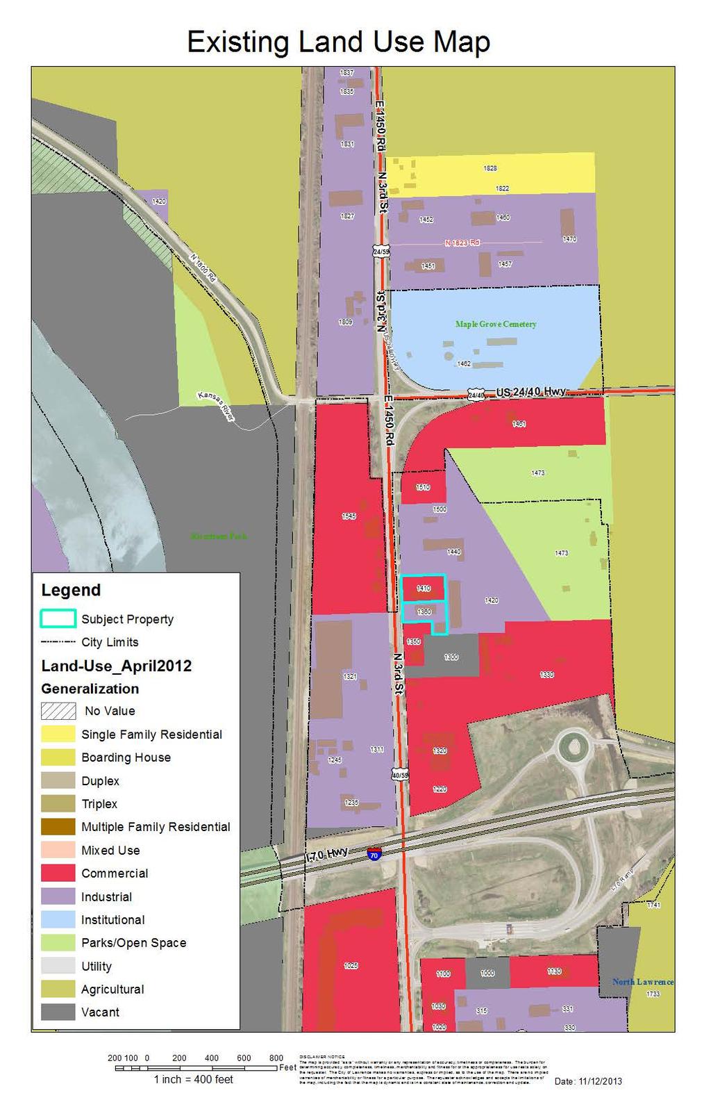
1 Z Item No. 1-1 PLANNING COMMISSION REPORT Regular Agenda - Public Hearing Item PC Staff Report 11/18/2013 ITEM NO. 1: Z IG (General Industrial) District TO CS (Strip Commercial) District; 1.95 Acres (SLD) Z : Consider a request to rezone approximately 1.95 acres from IG (General Industrial) District to CS (Strip Commercial) District, located at 1360, 1380, 1400, and 1410 N. 3 rd St. Submitted by Colliers International, for Evenshar, LLC., property owner of record. STAFF RECOMMENDATION: Staff recommends approval of the request to rezone approximately 1.95 acres, from IG (General Industrial) District to CS (Strip Commercial) District based on the findings presented in the staff report and forwarding it to the City Commission with a recommendation for approval. Reason for Request: The property is currently zoned IG, which is general industrial classification. This is a relatively intense classification and is generally found in large industrial parks such as East Hills and Santa Fe Park, where our major manufacturers and warehouse and distribution companies are location. Those users include companies such as Del Monte, Slumberger, Amarr Garage Doors, K-Mart Distribution, etc., and each of those businesses are housed in buildings of between 300,000 SF to more than one million SF. This IG classification allows some uses that would be considered inappropriate for this small area. A few of those includes; heavy equipment sales and rental, heavy warehouse and storage, truck stop, and explosive storage. There are also a number of uses that would be allowed in the CS classification that are not allowed in IG. Some of those include; lodge or fraternal assembly, a variety of recreation uses (such as sports coaching and camps), personal convenience or improvement (such as massage therapy), crematory, and consumer repair service (such as vacuum cleaners, computers, and sewing machines.) KEY POINTS Existing development of warehouse type buildings with multiple tenant spaces. ASSOCIATED CASES/OTHER ACTION REQUIRED SP N 3 rd Street; antique car restoration garage SP N 3 rd Street 4000 SF building addition to existing structure SP N 3 rd Street 3600 SF detached building addition PLANS AND STUDIES REQURIED Traffic Study Not required for rezoning Downstream Sanitary Sewer Analysis Not required for rezoning Drainage Study Not required for rezoning Retail Market Study Not applicable to residential request ATTACHMENTS Area Map Letter regarding crematory use Land Use Map PUBLIC COMMENT RECEIVED PRIOR TO PRINTING None received to date
2 Z Item No. 1-2 Project Summary: Proposed request is for a change in zoning to accommodate a wider range of uses for this property. This application is for two separate parcels of land located along the east side of N. 3 rd Street. The application included multiple addresses since several tenants within the existing buildings have independent addresses from the specific site address of 1360 N. 3 rd Street and 1410 N. 3 rd Street. The following table provides a summary of the subject property and improvements that are included in this request. Legal Description of property included in request Parcel Address Additional site addresses Lot 1 RM One Subdivision (.933 ac) 1360 N. 3 rd Street 1380 N. 3 rd Street 1400 N. 3 rd Street Lot 2 RM One Subdivision (1.03 ac) 1410 N. 3 rd Street 1412 N. 3 rd Street 1414 N. 3 rd Street 1. CONFORMANCE WITH THE COMPREHENSIVE PLAN Applicant s Response: The comprehensive plan indicates this general are in North Lawrence is appropriate for a variety of commercial and industrial uses. The N. 2 nd Street and N. 3 rd Street corridor is noted in Horizon 2020 as an existing commercial area. The plan states that this area should play an enhanced role in the community as a commercial corridor, acting as an important entryway/gateway to Lawrence. The plan suggests the relocation of heavy industrial uses and property be redeveloped with compatible commercial, service or retail uses. The property to the west (Advantage Metal) was recently annexed into the City of Lawrence. The property was rezoned to IG-FP. Although the property is located along the N. 2 nd and N. 3 rd Street Corridor as noted by Horizon 2020, the zoning prior to annexation was a county industrial district. The historic use of land for this property had been intensive industrial use and was proposed for redevelopment to an existing intensive industrial use. This is a consistent land use pattern along the west side of N. 3 rd Street. Additionally, the Advantage Metal property was identified as an industrial area as part of the Northeast Plan. The east side of N. 3 rd Street has a greater variety of uses, and generally, smaller lots along the frontage. The makeup of land uses in this immediate area includes a strong pattern of commercial uses especially located along the east side of N. 3 rd Street. [See land use map]. Horizon 2020 identifies this portion of the N. 3 rd Street corridor for Office Research, Industrial, Warehouse, and Distribution uses per Map 3-2. The land use map designation and the commercial chapter do not align for this area. Staff Finding The proposed zoning change will facilitate uses of this property consistent with the land use recommendation for this portion of the Corridor. 2. ZONING AND USE OF NEARBY PROPERTY, INCLUDING OVERLAY ZONING Current Zoning and Land Use: IG (General Industrial) District; existing buildings with multiple tenants spaces. Uses include vacant space, automotive repair and contractors sales and service uses.

3 Z Item No. 1-3 Surrounding Zoning and Land Use: IG (General Industrial) District to the north and east. The immediate north includes a shared access drive with the property to the east a contractor s sales and service use Paul Davis Restoration. Property farther to the north includes a manufacturing and production, technical use Scanning America. IG-FP (General Industrial and Floodplain Overlay) District to the west; Advantage Metals - a recycling facility and BC & R - storage. CS (Commercial Strip) District to the south. Existing eating and drinking establishment and open storage lot. Surrounding Zoning Surrounding Land Use Staff Finding The property is surrounded by both industrial zoning to the north, east and west and commercial zoning to the south. Surrounding uses vary widely between intensive industrial uses and commercial uses. 3. CHARACTER OF THE NEIGHBORHOOD Applicant s Response: The neighborhood includes a mix of light industrial uses such as; automotive repair, assembly, gas stations, warehouse; commercial uses such as car wash, restaurants, greenhouse, and sales of retail goods and services; and office uses such as call centers, contractor and sub-contractor offices. There are also agricultural uses in the surrounding area. This property is located in the area known as North Lawrence. However, it is not within the boundary of the designated North Lawrence Neighborhood. This property is located along the N.
4 Z Item No rd Street (Highway 40/59) corridor between US 24/40 and I-70. This segment of the corridor includes industrial and commercial uses as well as residential uses. The City Limit boundary in this location includes the east half of the right-of-way of N. 3 rd Street but does not include the west half of the right-of-way adjacent to the Advantage Metal Recycling facility located to the west of the subject properties. The average industrial parcel in this area is 4.7 acres. The largest is 13.2 acres. The smallest is.7 acres. The two properties proposed for rezoning are 1.02 acres and.92 acres (for 1410 N. 3 rd Street and 1400 N. 3 rd Street respectively). The total combined change of the subject properties from an industrial district to a non-industrial district is less than one-half percent of the total area along this segment of the corridor. These parcels are relatively small and less suitable for intensive industrial land uses. The distribution of industrial to non-industrial zoning in this area is roughly 51% to 49%. The proposed zoning change will not impact the overall character of this area. Staff Finding This property is located along the highway corridor between 24/40 and I-70. The area is characterized by a mix of industrial and commercial activities. 4. PLANS FOR THE AREA OR NEIGHBORHOOD, AS REFLECTED IN ADOPTED AREA AND/OR SECTOR PLANS INCLUDING THE PROPERTY OR ADJOINING PROPERTY This property is located in a portion of North Lawrence that is outside both the North Lawrence Neighborhood Plan boundary and the Northeast Sector Plan area. However, the corridor is influenced by both areas. The subject property is located along N. 3 rd Street, which is also a principal arterial, and a main corridor to the City of Lawrence as noted in Transportation Transportation 2040 notes that gateways into the city should be reviewed for aesthetic and informational enhancements when they are improved. At this time, there are no plans to redevelop or modify the property. This proposed request for CS zoning is to accommodate a wider range of uses suitable for mixed tenant buildings. There are no specific adopted land use area or sector plans that governing this area. Staff Finding There are no specific land use plans for this area at this time. As properties redevelop, a review of aesthetic elements and conformance with adopted design guidelines will be implemented. There are no proposed changes to the property at this time. 5. SUITABILITY OF SUBJECT PROPERTY FOR THE USES TO WHICH IT HAS BEEN RESTRICTED UNDER THE EXISTING ZONING REGULATIONS Applicant s Response: The buildings that comprise the subject property are not appropriate for many of the uses within the IG classification. Most of the IG zoning in Lawrence is concentrated in large industrial parks of 50 to several hundred acres such as East Hills, Lawrence Industrial Park, Santa Fe Park and Timberege Park. The subject property, which has been fully improved, is a total of just under two acres. Neither the location, nor the small size of the buildings on the site are suitable for many of the uses allowed in the IG District. Staff concurs with the applicant s statement that the subject properties are comparatively small for typical industrial development. The CS zoning allows a wider range of uses that are suitable for tenant spaces within the existing buildings. The land use recommendation for this area contained in Horizon 2020 is as a commercial area. The plan identifies the intersection of N. 3 rd Street and I-70 as a possible location for an auto related commercial center. These centers are characterized by containing a small amount of
5 Z Item No. 1-5 commercial square footage under roof but require a large area of parking or sales display. At this time, there are no plans for this type of development. The purpose of the IG District is primarily intended to accommodate moderate and high-impact industrial uses, including large scale or specialized industrial operations requiring good transportation access and public facilities and services. The District is generally incompatibility with residential areas and low-intensity commercial areas. (20-217). The existing development is not large scale or intensive in nature. The vehicle related uses that currently operate at this location are also allowed in the CS district. The purpose of the CS district is primarily intended to provide for existing commercial strip development along the City s major Arterial Streets. No new undeveloped parcel shall be zoned CS, except in the case where an undeveloped parcel is adjacent to an existing CS, then the adjacent undeveloped parcel maybe zoned to the classification CS to allow for expansion of an existing CS use onto the undeveloped adjacent parcel. (20-213). While this request does not fully meet this description this property is developed and used for a strip type development in the multi-tenant buildings. The property is adjacent to an existing CS property. This corridor is recommended for commercial development and this rezoning request facilitates reuse use of these buildings. Staff Finding The existing IG zoning is not suitable for these lots given the size and development pattern in this immediate area. The CS district is a more suitable district to facilitate tenant leases in the existing buildings. 6. LENGTH OF TIME SUBJECT PROPERTY HAS REMAINED VACANT AS ZONED Applicant s Response: The property is not vacant land, the land has had improvements constructed, but 2 of the 4 suites are currently vacant, and attempts to market the vacant suites over the last several months have not been successful. Many of the inquiries about the spaces have been from businesses that would not be allowed uses within the IG zoning classification. Both properties are developed with buildings that accommodate multiple tenants. The property has been zoned IG since 2006 upon the adoption of the Land Development Code. Prior to 2006 the property was zoned M-2 (General Industrial) District. The buildings were originally constructed in 1989 with additions made in Staff Finding This property is not currently vacant and is zoned for industrial uses. The existing development accommodates a variety of tenant spaces and uses which are more typically found in the CS District. 7. EXTENT TO WHICH APPROVING THE REZONING WILL DETRIMENTALLY AFFECT NEARBY PROPERTIES Applicant s Response: The zoning change should not have any detrimental effect on nearby properties. The adjoining property to the south has CS commercial zoning, which is a less intense classification, and some of the uses allowed in the IG would not be compatible with the CS uses next door. Many of the uses that would be allowed in the CS classification are either already existing uses in the area, or would be compatible uses with other tenants and owners in the area. There are also areas with residential zoning to the north, south, east, and CS would also be a better neighbor to those adjoining residential areas. The property located at 1360 N. 3 rd Street abuts existing CS zoning along the south property line. The property at 1410 N. 3 rd Street shares access with the adjacent lot to the east that will remain
6 Z Item No. 1-6 IG zoned. The purpose of the request is to allow greater flexibility of tenant space for nonindustrial uses within the existing development. There are no proposed changes to either property with regard to the physical development of the sites. Any change of use within either building will need to operate within the existing limits of the buildings and available surface parking. There are no detrimental impacts anticipated with this proposed rezoning. Staff Finding Approval of the request will not detrimentally impact adjacent properties. 8. THE GAIN, IF ANY, TO THE PUBLIC HEALTH, SAFETY AND WELFARE DUE TO THE DENIAL OF THE APPLICATION, AS COMPARED TO THE HARDSHIP IMPOSED UPON THE LANDOWNER, IF ANY, AS A RESULT OF DENIAL OF THE APPLICATION Applicant s Response: Having half of the suites vacant in this small park is a hardship on the owner, and it is a hardship on the adjoining owners. Vacant buildings are subject to neglect and vandalism, which can have a spillover impact on adjoining property owners and the condition and value of their properties. Occupied properties are better kempt, they have daily activity, they provide jobs and economic growth, and lend stability to the neighborhood. Expanding the positive uses that would be allowed under the CS classification would broaden the pool of prospects who might become tenants in these buildings. The uses that would be allowed would be positive additions to the immediate area as well as the larger surrounding neighborhood. Denial of the application would severely restrict the ability of the owners to find suitable tenants that would fit within the current classification. Evaluation of this criterion includes weighing the benefits to the public versus the benefit of the owners of the subject property. Benefits are measured based on anticipated impacts of the rezoning request on the public health, safety, and welfare. Benefits that could result from rezoning to CS include reinvestment in existing infrastructure and improvements and the potential to fill vacant space. The CS district offers a wider variety of uses than the current IG zoning for commercial oriented uses. Staff Finding New tenants represent the opportunity for public gains through reinvestment and revitalization of existing properties. Rezoning is unlikely to have harmful impacts. Approval of the request provides increased flexibility for uses that do not currently exist or this property. The size and location are not conducive to intensive industrial uses unless the property is substantially redeveloped. 9. PROFESSIONAL STAFF RECOMMENDATION The subject property is currently zoned IG (General Industrial) and thus is part of the industrial property inventory. Rezoning property from an industrial to a non-industrial classification should be considered in the context of the properties relevance to the overall inventory. Horizon 2020 identifies this corridor as commercial. Existing land use classifications include 1410 N. 3 rd Street as part of the commercial inventory. Approval of the request increases the types of land uses that may occupy existing vacant tenant spaces. The total land area included in the request is a small fraction of the overall industrially zoned land along this corridor.
7 Z Item No. 1-7 The impact of the proposed CS zoning is focused on the benefits to the property owner in his ability to fill vacant tenant spaces and offer a wider variety of optional uses for the site. As a result, the vicinity has the potential for reinvestment and vitality. There is no recognizable public harm by removing these properties from the industrial inventory. Staff recommends approval of the CS zoning. CONCLUSION While some uses allowed in the CS district (particularly multi-dwelling residential uses) would not be suitable for this location, it is highly unlikely the property would be redeveloped for such a use. Because the likelihood is so low for redevelopment of this type of use staff is not recommended the zoning be conditioned. It is probable that the CS zoning will foster reinvestment in the property as vacant tenant spaces are filled.
8
9 1461 B-2 RS A I-2 IG-FP 1545 Riverfront Park 1440 RS CS 1300 OS I IG / CS 1311 CS I-70 Ramp N 3rd St RS10 I-70 Hwy I-70 Hwy 70 I-70 Ramp CS 1025 I-70 Ramp I-1 Z : Rezone acres from IG District to CS District located at 1360 N 3rd Street and 1410 N 3rd Street Lawrence-Douglas County Planning Office November 2013 Subject Property µ
10
11
12
PLANNING COMMISSION REPORT Regular Agenda Public Hearing Item
 PC Staff Report 06/21/10 Item No. 4-1 PLANNING COMMISSION REPORT Regular Agenda Public Hearing Item ITEM NO. 4: PD-[TANGER PCD-1] TO CS; 1025 N. 3 rd STREET (SLD) : Consider a request to rezone approximately
PLANNING COMMISSION REPORT Regular Agenda - Public Hearing Item
 Z-14-00056 Item No. 1-1 PLANNING COMMISSION REPORT Regular Agenda - Public Hearing Item PC Staff Report 4/21/2014 ITEM NO. 1: RSO TO CN1;.126 ACRES; 512 & 514 LOCUST ST (DRG) Z-14-00056: Consider a request
PLANNING COMMISSION REPORT Regular Agenda - Public Hearing Item
 Z-15-00469 Item No. 6A- 1 PLANNING COMMISSION REPORT Regular Agenda - Public Hearing Item PC Staff Report 11/16/15 ITEM NO. 6A GPI, RM12, & RS40 TO RM12; 14.756 ACRES; 5200 & 5300 CLINTON PKWY (SLD) Z-15-00469:
PLANNING COMMISSION REPORT Regular Agenda Public Hearing Item
 PC Staff Report 6/20/16 Item No. 4-1 PLANNING COMMISSION REPORT Regular Agenda Public Hearing Item PC Staff Report 06/20/16 ITEM NO. 4: IG to CS 1.56 ACRES; 706 E 23 RD STREET (MKM) : Consider a request
PLANNING COMMISSION REPORT Regular Agenda - Public Hearing Item
 Z-11-25-09; Z-11-26-09; Z-11-28-09 Item No. 2-1 PC Staff Report 3/28/11 PLANNING COMMISSION REPORT Regular Agenda - Public Hearing Item ITEM NO. 2A RM32 TO MU;.19 ACRES; 1340 TENNESSEE ST (MJL) Z-1-1-11:
PLANNING COMMISSION REPORT Regular Agenda Public Hearing Item
 PC Staff Report 11/12/12 Item No. 2B- 1 PLANNING COMMISSION REPORT Regular Agenda Public Hearing Item ITEM NO. 2B: A TO GPI; 110 ACRES; E OF K-10 & N OF W 6 TH ST (MKM) : Consider a request to rezone approximately
PLANNING COMMISSION REPORT Regular Agenda Public Hearing Item
 PC Staff Report 2/22/16 Z-15-00640 Item No. 1-1 PLANNING COMMISSION REPORT Regular Agenda Public Hearing Item PC Staff Report 2/22/16 ITEM NO. 1 Villa 26 Apartments Rezoning from (Commercial Strip) to
PLANNING COMMISSION REPORT Regular Agenda Public Hearing Item. IG TO IL;.972 ACRES; 1021 E 31st (KES)
") PC Staff Report 11/16/15 Z-15-00471 Item No. 7-1 PLANNING COMMISSION REPORT Regular Agenda Public Hearing Item PC Staff Report 11/16/15 ITEM NO. 7 IG TO IL;.972 ACRES; 1021 E 31st (KES) Z-15-00471: Consider
PC Staff Report 11/16/15 Z-15-00471 Item No. 7-1 PLANNING COMMISSION REPORT Regular Agenda Public Hearing Item PC Staff Report 11/16/15 ITEM NO. 7 IG TO IL;.972 ACRES; 1021 E 31st (KES) Z-15-00471: Consider
PLANNING COMMISSION REPORT Regular Agenda Public Hearing Item
 PC Staff Report 10/21/2013 Item No. 3B - 1 PC Staff Report 10/21/2013 ITEM NO. 3B: PLANNING COMMISSION REPORT Regular Agenda Public Hearing Item A TO CR- FP; 8.4 ACRES; 1900 W. 31 st STREET (SLD) : Consider
PLANNING COMMISSION REPORT Regular Agenda Public Hearing Item PRD TO RM15; ACRES; 2101 EXCHANGE CT (KES)
") PC Staff Report 7/22/15 Z-14-00515 Item No. 3-1 PLANNING COMMISSION REPORT Regular Agenda Public Hearing Item PC Staff Report 7/22/15 ITEM NO. 3 PRD TO RM15; 9.818 ACRES; 2101 EXCHANGE CT (KES) Z-14-00515:
PC Staff Report 7/22/15 Z-14-00515 Item No. 3-1 PLANNING COMMISSION REPORT Regular Agenda Public Hearing Item PC Staff Report 7/22/15 ITEM NO. 3 PRD TO RM15; 9.818 ACRES; 2101 EXCHANGE CT (KES) Z-14-00515:
PLANNING COMMISSION REPORT Regular Agenda - Public Hearing Item
 Z-12-29, 30, 32, 33, 34, 35, 36-11 to Item No. 5A 5G- 1 PLANNING COMMISSION REPORT Regular Agenda - Public Hearing Item PC Staff Report 02/27/2012 ITEM NO. 5A-5G Z-12-29, 30, 32, 33, 34, 35, 36-11 from
PLANNING COMMISSION REPORT Regular Agenda -Public Hearing Item
 PDP-13-00518 Item No. 3B- 1 PLANNING COMMISSION REPORT Regular Agenda -Public Hearing Item PC Staff Report 2/24/14 ITEM NO. 3B PRELIMINARY DEVELOPMENT PLAN FOR HERE @ KANSAS; 1101 INDIANA ST (SLD) PDP-13-00518:
PLANNING COMMISSION REPORT Regular Agenda Public Hearing Item CONDITIONAL USE PERMIT FOR VERIZON WIRELESS; 1287 E 1200 RD (SLD)
") PC Staff Report 9/26/2016 CUP-16-00312 Item No. 5-1 PC Staff Report 9/26/2016 ITEM NO. 5 PLANNING COMMISSION REPORT Regular Agenda Public Hearing Item CONDITIONAL USE PERMIT FOR VERIZON WIRELESS; 1287
PC Staff Report 9/26/2016 CUP-16-00312 Item No. 5-1 PC Staff Report 9/26/2016 ITEM NO. 5 PLANNING COMMISSION REPORT Regular Agenda Public Hearing Item CONDITIONAL USE PERMIT FOR VERIZON WIRELESS; 1287
Allow continued use of existing grass runway for personal use by landowner.
 CUP-13-00193 Item No. 4-1 PLANNING COMMISSION REPORT Regular Agenda PC Staff Report 7/22/13 ITEM NO. 4: CONDITIONAL USE PERMIT; PRIVATE LANDING STRIP; 2215 N 500 (MKM) CUP-13-00193: Consider a Conditional
PLANNING COMMISSION REPORT Regular Agenda Public Hearing Item
 CUP-15-00474 Item No. 5-1 PC Staff Report 11/16/15 ITEM NO. 5 PLANNING COMMISSION REPORT Regular Agenda Public Hearing Item CONDITIONAL USE PERMIT FOR PUBLIC WHOLESALE WATER SUPPLY DISTRICT NO. 25; E 1300
PLANNING COMMISSION REPORT REGULAR AGENDA
 PP-4-4-11 Item No. 9-1 PLANNING COMMISSION REPORT REGULAR AGENDA PC Staff Report 06/22/11 ITEM NO 9: PRELIMINARY PLAT; KASOLD WATER TOWER ADDITION; SE OF TAM O SHANTER & KASOLD DR (MKM) PP-4-4-11: Consider
PLANNING COMMISSION REPORT Regular Agenda Public Hearing Item
 PC Staff Report 06/22/2015 Item No. 3A - 1 PC Staff Report 6/22/2015 ITEM NO. 3A: PLANNING COMMISSION REPORT Regular Agenda Public Hearing Item RSO TO CN2; 10 ACRES; 4300 W 24 th Place (SLD) : Consider
Appendix A: Guide to Zoning Categories Prince George's County, Maryland
 Appendix A: Guide to Zoning Categories Prince George's County, Maryland RESIDENTIAL ZONES 1 Updated November 2010 R-O-S: Reserved Open Space - Provides for permanent maintenance of certain areas of land
Planning Department Oconee County, Georgia
 Planning Department Oconee County, Georgia STAFF REPORT REZONE CASE #: 6985 DATE: October 31, 2016 STAFF REPORT BY: Andrew C. Stern, Planner APPLICANT NAME: Williams & Associates, Land Planners PC PROPERTY
PLANNING & DEVELOPMENT
 PLANNING & DEVELOPMENT STAFF REPORT Rezoning PETITION: APPLICANT: PROPERTY OWNER: TYPE OF REQUEST: SIZE OF TRACT: LOCATION: (#17-22) Rezone from A-PUD (Agri-Business Planned Unit Development) to A-PUD
Planning & Zoning Commission
 Zoning Change 13-03 (FM 646) Planning & Zoning Commission Planning & Development Department June 3, 2013 Request Permitted Uses Rezone approximately 24.89 acres of undeveloped land from RSF-7 (Residential
City of Valdosta Land Development Regulations
 Chapter 206 Section 206-1 Base Zoning Districts Standards for Uses, Structures, and Property Development (B) (C) Principal Uses and Structures. Principal uses and structures permitted in each base zoning
DRAFT. Amendment to the Master Plan Land Use Element for Block 5002, Lot Township of Teaneck, Bergen County, New Jersey.
 DRAFT Amendment to the Master Plan Land Use Element for Block 5002, Lot 18.01 Township of Teaneck, Bergen County, New Jersey Prepared for: Township of Teaneck Planning Board Prepared by: Janice Talley,
GENERAL DESCRIPTION STAFF RECOMMENDATION IMPLEMENTATION REQUIREMENTS
 Application No.: 891418 Applicant: AREA-WIDE MAP AMENDMENT Rezone two parcels from Moderate Density Single Family (MSF) to Neighborhood Center (NC) and Employment Center (EC). Charles Bitton GENERAL DESCRIPTION
ARTICLE B ZONING DISTRICTS
 ARTICLE B ZONING DISTRICTS Sec. 8-3021 Established. In order to protect the character of existing neighborhoods; to prevent excessive density of population in areas which are not adequately served with
Generic Environmental Impact Statement. Build-Out Analysis. City of Buffalo, New York. Prepared by:
 Generic Environmental Impact Statement Build-Out Analysis City of Buffalo, New York 2015 Prepared by: TABLE OF CONTENTS 1.0 INTRODUCTION 1 2.0 METHODOLOGY 2 3.0 EXISTING LAND USE 3 4.0 EXISTING ZONING
PLANNING COMMISSION REPORT REGULAR AGENDA. PC Staff Report 08/25/10 ITEM NO 6: PRELIMINARY PLAT; HALLMARK ADDITION; ACRES; 151 MCDONALD DR (MKM)
") PP-6-6-10 Item No. 6-1 PLANNING COMMISSION REPORT REGULAR AGENDA PC Staff Report 08/25/10 ITEM NO 6: PRELIMINARY PLAT; HALLMARK ADDITION; 5.252 ACRES; 151 MCDONALD DR (MKM) PP-6-6-10: Consider a Preliminary
PP-6-6-10 Item No. 6-1 PLANNING COMMISSION REPORT REGULAR AGENDA PC Staff Report 08/25/10 ITEM NO 6: PRELIMINARY PLAT; HALLMARK ADDITION; 5.252 ACRES; 151 MCDONALD DR (MKM) PP-6-6-10: Consider a Preliminary
ORDINANCE NO. NOW, THEREFORE, BE IT ORDAINED BY THE CITY COUNCIL OF THE CITY OF BRYAN, TEXAS:
 LOCATION MAPS: ORDINANCE NO. AN ORDINANCE OF THE CITY OF BRYAN, TEXAS, AMENDING CHAPTER 130, ZONING, OF THE CITY OF BRYAN CODE OF ORDINANCES, BY CHANGING THE ZONING CLASSIFICATION FROM AGRICULTURAL - OPEN
Urban Planning and Land Use
 Urban Planning and Land Use 701 North 7 th Street, Room 423 Phone: (913) 573-5750 Kansas City, Kansas 66101 Fax: (913) 573-5796 Email: planninginfo@wycokck.org www.wycokck.org/planning To: From: City Planning
ACTION FORM BRYAN CITY COUNCIL
 ACTION FORM BRYAN CITY COUNCIL DATE OF COUNCIL MEETING: July 8, 2014 DATE SUBMITTED: June 17, 2014 DEPARTMENT OF ORIGIN: Development Services SUBMITTED BY: Maggie Dalton MEETING TYPE: CLASSIFICATION: ORDINANCE:
STAFF REPORT. Permit Number: Unlimited. Kitsap County Board of Commissioners; Kitsap County Planning Commission
 STAFF REPORT Permit Number: 15 00550 Unlimited DATE: March 2, 2016 TO: FROM: Kitsap County Board of Commissioners; Kitsap County Planning Commission Katrina Knutson, AICP, Senior Planner, DCD and Jeff
SUBDIVISION, PLANNED UNIT DEVELOPMENT, ZONING AMENDMENT, & SIDEWALK WAIVER STAFF REPORT Date: July 19, 2018
 SUBDIVISION, PLANNED UNIT DEVELOPMENT, ZONING AMENDMENT, & SIDEWALK WAIVER STAFF REPORT Date: July 19, 2018 NAME SUBDIVISION NAME LOCATION West Mobile Properties, LLC U.S. Machine Subdivision 556, 566,
RM18 RS9 RM12 RS9 !( S DOCKET #: W3120 PROPOSED ZONING: GB-L EXISTING ZONING: HB-S. PETITIONER: Bank of North Carolina for property owned by Same
 DELANE DR DOCKET #: W3120 RM18 BARRY ST PROPOSED ZONING: GB-L RS9 EXISTING ZONING: HB-S IP OLD GREENSBORO RD WALES ST DENVER ST GEORGE BIG REDD CT LOUISE WILSON LN RM12!(DS MOSES LUCAS CT 585' 627' HB-S
Urban Planning and Land Use
 Urban Planning and Land Use 701 North 7 th Street, Room 423 Phone: (913) 573-5750 Kansas City, Kansas 66101 Fax: (913) 573-5796 Email: planninginfo@wycokck.org www.wycokck.org/planning To: From: City Planning
Marcel Williams, MPC Project Planner
 TO: FROM: The Planning Commission MPC Staff DATE: SUBJECT: Petition to Rezone Property Heath Shelton, Owner Jay Maupin, Agent 2026 Habersham Street Aldermanic District: 2, Bill Durrence County Commission
Town of Waxhaw Board of Commissioners. Waxhaw Police Department Community Meeting Room Tuesday January 12, 2016
 Town of Waxhaw Board of Commissioners Waxhaw Police Department Community Meeting Room Tuesday January 12, 2016 Petition RZ-003994-2015 A request by the Town of Waxhaw Planning & Community Development Department,
Draft Model Access Management Overlay Ordinance
 Draft Model Access Management Overlay Ordinance This model was developed using the City of Hutchinson and the Trunk Highway 7 corridor. The basic provisions of this model may be adopted by any jurisdiction
STAFF REPORT. Community Development Director PO Box 4755 Beaverton, OR 97076
 STAFF REPORT HEARING DATE: July 7, 2010 TO: Planning Commission STAFF: Jana Fox, Assistant Planner PROPOSAL: Southeast Beaverton Office Commercial Zoning Map Amendment (ZMA2010-0006) LOCATION: The subject
ARTICLE 3: Zone Districts
 ARTICLE 3: Zone Districts... 3-1 17.3.1: General...3-1 17.3.1.1: Purpose and Intent... 3-1 17.3.2: Districts and Maps...3-1 17.3.2.1: Applicability... 3-1 17.3.2.2: Creation of Districts... 3-1 17.3.2.3:
INDIAN RIVER COUNTY, FLORIDA. The Honorable Members of the Planning and Zoning Commission DEPARTMENT HEAD CONCURRENCE
 Public Hearing Legislative INDIAN RIVER COUNTY, FLORIDA M E M O R A N D U M TO: The Honorable Members of the Planning and Zoning Commission DEPARTMENT HEAD CONCURRENCE Robert M. Keating, AICP; Community
Subdivision of existing two lots into three lots.
 PP-15-00189 Item No. 4-1 PC Staff Report 06/22/2015 PLANNING COMMISSION REPORT NON PUBLIC HEARING ITEM PUBLIC HEARING ON THE VARIANCE ONLY ITEM NO 4: PRELIMINARY PLAT FOR DEERFIELD WOODS SUBDIVISION NO.
United States Post Office and Multi-Family Residential; and, Single- Family Residence with an Apartment
 Planning Commission File No.: AME2013 0009 January 9, 2014 Page 2 of 9 Existing Land Use: United States Post Office and Multi-Family Residential; and, Single- Family Residence with an Apartment Surrounding
Metropolitan Planning Commission. DATE: April 5, 2016
 TO: FROM: Metropolitan Planning Commission MPC Staff DATE: April 5, 2016 SUBJECT: Petition of Nine Line Inc. Robert McCorkle, Agent PIN: 2-1034-01-002 380.5 Acres Aldermanic District: 5 (Shabazz) County
Glades County Staff Report and Recommendation Unified Staff Report for Small Scale Plan Amendment and Rezoning
 Glades County Staff Report and Recommendation Unified Staff Report for Small Scale Plan Amendment and Rezoning CASE NUMBERS: COMP17-02 and RZ17-02 DATE of STAFF REPORT: May 1, 2017 CASE TYPE: Application
Midwest City, Oklahoma Zoning Ordinance
 2010 Midwest City, Oklahoma Zoning Ordinance 9/2/2010 Table of Contents Section 1. General Provisions... 5 1.1. Citation... 5 1.2. Authority... 5 1.3. Purpose... 5 1.4. Nature and Application... 5 1.5.
DIVISION 1 PURPOSE OF DISTRICTS
 ARTICLE 2 ZONING DISTRICTS AND MAP DIVISION 1 PURPOSE OF DISTRICTS Section 2.101 Zoning Districts. For the purpose of this Ordinance, the City of Richmond is hereby divided into districts as follows: DISTRICT
Planning Justification Report
 Planning Justification Report Kellogg s Lands City of London E&E McLaughlin Ltd. June 14, 2017 Zelinka Priamo Ltd. Page i TABLE OF CONTENTS Page No. 1.0 2.0 2.1 2.2 3.0 4.0 5.0 5.1 5.2 5.3 5.4 5.5 5.6
Urban Planning and Land Use
 Urban Planning and Land Use 701 North 7 th Street, Room 423 Phone: (913) 573-5750 Kansas City, Kansas 66101 Fax: (913) 573-5796 Email: planninginfo@wycokck.org www.wycokck.org/planning To: From: City Planning
Urban Planning and Land Use
 Urban Planning and Land Use 701 North 7 th Street, Room 423 Phone: (913) 573-5750 Kansas City, Kansas 66101 Fax: (913) 573-5796 Email: planninginfo@wycokck.org www.wycokck.org/planning To: From: City Planning
Wednesday, January 4, E CESAR CHAVEZ ST 78702
 Brooks Wolff bwolff@independencetitle.com Prepared For: Date Prepared: Subject Address: Subject Property ID: 188883 Wednesday, January 4, 2017 1407 E CESAR CHAVEZ ST 78702 Do not use this report to make
Urban Planning and Land Use
 Urban Planning and Land Use 701 North 7th Street, Room 423 Kansas City, Kansas 66101 Email: planninginfo@wycokck.org Phone: (913) 573-5750 Fax: (913) 573-5796 www.wycokck.org/planning To: City Planning
COMMERCIAL ZONING DISTRICTS (Amended 11/13/14) Part I. C-1 Restricted Commercial District
 Part I. C-1 Restricted Commercial District") ARTICLE XI. COMMERCIAL ZONING DISTRICTS (Amended 11/13/14) Part I. C-1 Restricted Commercial District Section 152: Purpose This district is designed to accommodate commercial uses which act as a transition
ARTICLE XI. COMMERCIAL ZONING DISTRICTS (Amended 11/13/14) Part I. C-1 Restricted Commercial District Section 152: Purpose This district is designed to accommodate commercial uses which act as a transition
REZONING APPLICATION INSTRUCTIONS
 REZONING APPLICATION INSTRUCTIONS All required information, as stated on the Rezoning Application Checklist, must be included to qualify as a complete application. Upon receipt, staff will review the application
COMMISSION ACTION FORM SUBJECT: ZONING TEXT AMENDMENT FOR LINCOLN WAY CORRIDOR PLAN DOWNTOWN GATEWAY COMMERCIAL ZONING DISTRICT STANDARDS
 ITEM #: 7 DATE: _02-07-18 COMMISSION ACTION FORM SUBJECT: ZONING TEXT AMENDMENT FOR LINCOLN WAY CORRIDOR PLAN DOWNTOWN GATEWAY COMMERCIAL ZONING DISTRICT STANDARDS BACKGROUND: The Downtown Gateway area
Staff Report. Planning Commission Public Hearing: October 17, 2007 Staff Recommendation: Denial
 COUNTY OF PRINCE WILLIAM 5 County Complex Court, Prince William, Virginia 22192-9201 PLANNING (703) 792-6830 Metro 631-1703, Ext. 6830 FAX (703) 792-4401 OFFICE Internet www.pwcgov.org Stephen K. Griffin,
4.2 LAND USE INTRODUCTION
 4.2 LAND USE INTRODUCTION This section of the EIR addresses potential impacts from the Fresno County General Plan Update on land use in two general areas: land use compatibility and plan consistency. Under
Master Plan Review SILVER SPRING CBD. Approved and Adopted February Updated January 2013
 Master Plan Review SILVER SPRING CBD Approved and Adopted February 2000 BACKGROUND ZONING CODE REWRITE In 2007, the Montgomery County Council directed the Planning Department to undertake a comprehensive
Salem HNA and EOA Advisory Committee Meeting #6
 Salem HNA and EOA Advisory Committee Meeting #6 Residential Land Policies Employment Land Policies Policy Discussions with the Committee Outcome of today s meeting Direction from this Committee on proposed
HB-S RM8-S RS9 RM18 HB-S RS9 DOCKET #: W2872. PROPOSED ZONING: RM8-S (Child Day Care Center) EXISTING ZONING: RS9 and RM8-S
 EXISTING ZONING: RS9 and RM8-S") 150' 80' RS9 UNIVERSITY PW STANLEYVILLE DR HB-S LB 123' 70' PROPOSED BELTWAY!( RM8-S S 289' NOEL DR 202' NITA AV MILL CREEK DOCKET #: W2872 PROPOSED ZONING: RM8-S (Child Day Care Center) EXISTING ZONING:
150' 80' RS9 UNIVERSITY PW STANLEYVILLE DR HB-S LB 123' 70' PROPOSED BELTWAY!( RM8-S S 289' NOEL DR 202' NITA AV MILL CREEK DOCKET #: W2872 PROPOSED ZONING: RM8-S (Child Day Care Center) EXISTING ZONING:
Hamilton County Regional Planning Commission
 Hamilton County Regional Planning Commission March 1, 2012 Colerain Township Staff Report Zone Map Amendment: Case No.: ZA2012-01 Joseph Toyota Prepared By: Amy Bancroft, Land Use Planner ACTION REQUESTED:
City of Peachtree City. Annexation Review Process
 City of Peachtree City Annexation Review Process Page 1 Annexation Review Process Step One: Initial annexation information The following information is to be completed by the property owner and/ or their
COMMUNITY DEVELOPMENT. Staff Report. Site Plan Review. SP June 19, 2018
 COMMUNITY DEVELOPMENT 333 Broadalbin Street SW, PO Box 490, Albany, Oregon 97321-0144 BUILDING 541-917-7553 PLANNING 541-917-7550 Staff Report Site Plan Review SP-18-18 June 19, 2018 Summary On May 1,
FUTURE LAND USE. City of St. Augustine Comprehensive Plan EAR-Based Amendments
 FUTURE LAND USE City of St. Augustine Comprehensive Plan EAR-Based Amendments Future Land Use Element FLU Goal To create an environment within the City and adjacent areas in which its residents have the
410 Land Use Trends Comprehensive Plan Section 410
 411 410 Comprehensive Plan Section 410 In order to plan future land use, we must know how the land is used today. This section includes the following: Definition of analyzed land-use categories Summary
PLANNING COMMISSION REPORT PUBLIC HEARING ITEM. DE-ANNEXATION OF 2.4 ACRES LOCATED AT 1820 N. 3 rd STREET. (DDW)
") A-6-1-10 Item No. 5-1 PC Staff Report 9/20/10 PLANNING COMMISSION REPORT PUBLIC HEARING ITEM ITEM NO. 5: DE-ANNEXATION OF 2.4 ACRES LOCATED AT 1820 N. 3 rd STREET. (DDW) A-6-1-10: De-annexation of approximately
A-6-1-10 Item No. 5-1 PC Staff Report 9/20/10 PLANNING COMMISSION REPORT PUBLIC HEARING ITEM ITEM NO. 5: DE-ANNEXATION OF 2.4 ACRES LOCATED AT 1820 N. 3 rd STREET. (DDW) A-6-1-10: De-annexation of approximately
David J. Gellner, AICP, Principal Planner; (801) ; Zoning Map Amendment
 ; Zoning Map Amendment") Staff Report PLANNING DIVISION DEPARTMENT of COMMUNITY and NEIGHBORHOODS To: From: Salt Lake City Planning Commission David J. Gellner, AICP, Principal Planner; (801) 535-6107; david.gellner@slcgov.com
Staff Report PLANNING DIVISION DEPARTMENT of COMMUNITY and NEIGHBORHOODS To: From: Salt Lake City Planning Commission David J. Gellner, AICP, Principal Planner; (801) 535-6107; david.gellner@slcgov.com
Rapid City Planning Commission Rezoning Project Report
 Rapid City Planning Commission Rezoning Project Report April 21, 2016 Item #9 Applicant Request(s) Case # 16RZ011; a request to rezone property from Central Business District to General Commercial District
PLANNING AND DEVELOPMENT DEPARTMENT STAFF REPORT SAVOY DRIVE AREA ZONING MAP AMENDMENT II
 PLANNING AND DEVELOPMENT DEPARTMENT STAFF REPORT Meeting Date: March 14, 2019 Item #: PZ2019-429 SAVOY DRIVE AREA ZONING MAP AMENDMENT II Project Name: Savoy Drive Area Zoning Map Amendment II Site Addresses:
MEMORANDUM. DATE: November 9, 2016 PC Agenda Item 3.B. Planning Commission Chair Thompson and Commissioners
 MEMORANDUM DATE: November 9, 2016 PC Agenda Item 3.B TO: FROM: SUBJECT: Planning Commission Chair Thompson and Commissioners Matthew Bachler, Senior Planner Planning Case #16-028 Public Hearing Required
ARTICLE 2 ZONING DISTRICTS AND MAPS
 ARTICLE 2 ZONING DISTRICTS AND MAPS SECTION 2.100 PURPOSE OF DISTRICTS Section 2.101. For the purpose of this Ordinance, Billings Township is hereby divided into districts as follows: DISTRICT NAME SYMBOL
Planning & Zoning Commission
 Planning & Zoning Commission Planning & Development Department August 14, 01 Zoning Map Amendment MAP-1-0001 (Bay View Section 4) Request Rezone approximately 1.19 acres from OS (Open Space) to RSF- (Residential
Conditional Use Permit case no. CU 14-06: Bristol Village Partners, LLC
 PLANNING AND ZONING COMMISSION STAFF REPORT August 7, 2014 Conditional Use Permit case no. CU 14-06: Bristol Village Partners, LLC CASE DESCRIPTION: LOCATION: LEGAL DESCRIPTION: EXISTING LAND USE: ZONING:
THE REDEVELOPMENT PLAN
 PAGE 37 THE REDEVELOPMENT PLAN FUTURE LAND USE The Silver Terrace Redevelopment Area is currently designated as Redevelopment Area #4 on the City of Delray Beach Future Land Use Map (FLUM). This designation
Town of. River Falls. Land Use Element Vierbicher Associates, Inc
 Town of River Falls 2005 Vierbicher Associates, Inc Contents Contents s. 66.1001(2)(h) Wis. Stats................................................. ii Introduction................................................................
Urban Planning and Land Use
 Urban Planning and Land Use 701 North 7 th Street, Room 423 Phone: (913) 573-5750 Kansas City, Kansas 66101 Fax: (913) 573-5796 Email: planninginfo@wycokck.org www.wycokck.org/planning To: From: City Planning
To: Flathead County Planning Board
 PO Box 771 l 35 4 th Street West Kalispell, Montana 59903 citizens@flatheadcitizens.org T: 406.756.8993 l F: 406.756.8991 www.flatheadcitizens.org To: Flathead County Planning Board Re: FZC-16-15 and a
PLANNING COMMISSION REPORT Regular Agenda Public Hearing Item. PC Staff Report 12/14/15 A (County) TO RS10; 3 ACRES; 1041 N 1700 Road (KES)
 TO RS10; 3 ACRES; 1041 N 1700 Road (KES)") PC Staff Report 12/14/15 Z-15-00524 Item No. 3-1 PLNNING COMMISSION REPORT Regular genda Public Hearing Item PC Staff Report 12/14/15 ITEM NO. 3 (County) TO RS10; 3 CRES; 1041 N 1700 Road (KES) Z-15-00524:
PC Staff Report 12/14/15 Z-15-00524 Item No. 3-1 PLNNING COMMISSION REPORT Regular genda Public Hearing Item PC Staff Report 12/14/15 ITEM NO. 3 (County) TO RS10; 3 CRES; 1041 N 1700 Road (KES) Z-15-00524:
Zoning Districts Agriculture Low Density Rural Residential Moderate Density Rural Residential High Density Rural Residential Manufactured Home Park
 Zoning 201 Zoning Districts Agriculture Low Density Rural Residential Moderate Density Rural Residential High Density Rural Residential Manufactured Home Park Commercial Lakeside Commercial Rural Transitional
9. REZONING NO Vicinity of the northwest corner of 143 rd Street and Metcalf Avenue
 9. REZONING NO. 2002-15 Vicinity of the northwest corner of 143 rd Street and Metcalf Avenue 1. APPLICANT: Andrew Schlagel is the applicant for this request. 2. REQUESTED ACTION: The applicant is requesting
RS9 LB-S RSQ-S RS9 RS9 DOCKET: W2822 PROPOSED ZONING: LB EXISTING ZONING: RS-9. PETITIONER: J&J Properties of W-S, LLC, for property owned by Same
 HAYMOUNT ST RS9 IP DOCKET: W2822 PROPOSED ZONING: LB POPE RD CLEMMONSVILLE RD EXISTING ZONING: RS-9 RSQ-S LB-S OLD SALISBURY RD WINSTON-SALEM ZONING FORSYTH COUNTY ZONING PETITIONER: J&J Properties of
CPC Agenda July 18, 2013 Page 56 ITEM: E FILE NO: CORPORAT SITE
 Page 56 CITY PLANNING COMMISSION AGENDA ITEM: E STAFF: PETER WYSOCKI FILE NO: CPCC UV 13-00060 QUASI-JUDICIAL PROJECT: APPLICANT: CORPORAT TE CENTER FILING NO. 5 YOW ARCHITECTS OWNER: COLUMBUS REAL ESTATE
COLERAIN TOWNSHIP ZONING COMMISSION Regular Meeting Tuesday, September 19, :00 p.m.
 COLERAIN TOWNSHIP ZONING COMMISSION Regular Meeting Tuesday, September 19, 2017-6:00 p.m. Colerain Township Government Complex 4200 Springdale Road - Cincinnati, OH 45251 1. Meeting called to order. Pledge
Urban Planning and Land Use
 Urban Planning and Land Use 701 North 7 th Street, Room 423 Phone: (913) 573-5750 Kansas City, Kansas 66101 Fax: (913) 573-5796 Email: planninginfo@wycokck.org www.wycokck.org/planning To: From: City Planning
Urban Planning and Land Use
 Urban Planning and Land Use 701 North 7 th Street, Room 423 Phone: (913) 573-5750 Kansas City, Kansas 66101 Fax: (913) 573-5796 Email: planninginfo@wycokck.org www.wycokck.org/planning To: From: City Planning
3 NOVEMBER 9, 2011 Public Hearing APPLICANT:
 REQUEST: Conditional Change of Zoning (B-2 & I-1 to Conditional A-18) 3 NOVEMBER 9, 2011 Public Hearing APPLICANT: S.L. NUSBAUM REALTY COMPANY PROPERTY OWNER: USF PROPCO II, LLC STAFF PLANNER: Leslie Bonilla
MPC STAFF REPORT REZONING MAP AMENDMENT ALDERMANIC DISTRICT 1 COUNTY COMMISSION DISTRICT 5 April 3, 2013 MPC FILE NUMBER.
 MPC STAFF REPORT REZONING MAP AMENDMENT ALDERMANIC DISTRICT 1 COUNTY COMMISSION DISTRICT 5 April 3, 2013 MPC FILE NUMBER. 13-000929-ZA REZONING SUMMARY Report Status Initial Report Petitioner/Property
RESOLUTION NO
 ITEM 4 ATTACHMENT B RESOLUTION NO. 2014-1412 A RESOLUTION OF THE CITY COUNCIL OF THE CITY OF CALABASAS APPROVING GENERAL PLAN AMENDMENTS ASSOCIATED WITH THE WEST AGOURA ROAD TERRITORY IN CONFORMANCE WITH
To ensure a smooth transition from the County to City jurisdiction for planning and development regulation
 City of Grande Prairie Municipal Development Plan and Land Use Bylaw Concept for transitioning Short Term Annexation Area lands into the City s policy framework and land use development control regime.
Final. Chapter Four: Land Use
 Chapter Four: Land Use Purpose and Intent Goals and Policies Existing Land Use Patterns AICUZ Airport Overlay Zone Zoning Existing Land Use Land Use Designations Land Use Demand and Forecast Existing Population
ARTICLE 3 ZONING DISTRICTS AND ZONING MAP. Table of Contents
 ARTICLE 3 ZONING DISTRICTS AND ZONING MAP Table of Contents 3-1 Establishment of Zoning Districts... 1 A. General Use Zoning Districts... 1 B. Conditional Zoning Districts... 3 C. Overlay Zoning Districts...
AGENDA PLANNING COMMISSION
 AGENDA PLANNING COMMISSION Tuesday, November 27, 2018 5:30 PM City Council Chambers 125 E Avenue B, Hutchinson, Kansas 1. ROLL CALL Richardson Vacant Bisbee Hamilton Wells Roberts-Ropp Carr (Vice Chair)
PLANNING COMMISSION RESOLUTION NO
 Exhibit A PLANNING COMMISSION RESOLUTION NO. 2014-566 A RESOLUTION OF THE PLANNING COMMISSION OF THE CITY OF CALABASAS RECOMMENDING TO THE CITY COUNCIL APPROVAL OF FILE NO. 140000288, GENERAL PLAN AMENDMENTS
Memorandum City of Lawrence Planning & Development Services
 Memorandum City of Lawrence Planning & Development Services TO: City Commission FROM: Planning Staff Date: July 11, 2017 RE: Industrial District Review Attachments: 1. Existing Industrial Zoning Map 2.
UDO Advisory Committee Meeting #3 August 18, 2011
 UDO Advisory Committee Meeting #3 August 18, 2011 Today s s Agenda Welcome Recap of Meeting #2 Overview of Strategy Statement Overview of Zoning Districts What changes and what stays the same? Break Putting
Staff Report & Recommendation Rezoning Case RZ Date of Report: June 6, 2014 Report by: Doug Stacks
 Staff Report & Recommendation Rezoning Case RZ-2014-02 Date of Report: June 6, 2014 Report by: Doug Stacks Hearing Dates: Planning Commission June 26, 2014 Mayor and Council July 14, 2014 GENERAL INFORMATION
ii. That the driveway access from Desloges Road be controlled with a gate and access only be used for maintenance and emergency purposes; and,
 Presented To: Planning Committee Request for Decision Melissa Cotesta - Application for rezoning in order to permit a contractor s yard and warehouse, Pioneer Road, Sudbury Presented: Monday, Jun 27, 2016
13 Sectional Map Amendment
 13 Sectional Map Amendment Introduction This chapter reviews land use and zoning policies and practices in Prince George s County and presents the proposed zoning in the sectional map amendment (SMA) to
PLANNING ANALYSIS ZONING CASE 18-TOD-Z-026 NAK S CROSSING PUD AMENDMENT. GC-3-A (General Commercial) GC-3-A (General Commercial)
 GC-3-A (General Commercial)") PLANNING ANALYSIS ZONING CASE 18-TOD-Z-026 NAK S CROSSING PUD AMENDMENT GENERAL INFORMATION Applicant/Owner: Current Zoning: Bruce Nakfoor PUD/TOD (Planned Unit Development/Transit Oriented Development
PLANNING ANALYSIS ZONING CASE 18-TOD-Z-026 NAK S CROSSING PUD AMENDMENT GENERAL INFORMATION Applicant/Owner: Current Zoning: Bruce Nakfoor PUD/TOD (Planned Unit Development/Transit Oriented Development
Implementation. Approved Master Plan and SMA for Henson Creek-South Potomac 103
 Implementation Approved Master Plan and SMA for Henson Creek-South Potomac 103 104 Approved Master Plan and SMA for Henson Creek-South Potomac Sectional Map Amendment The land use recommendations in the
STAFF: RACHEL TEIXEIRA
 Page 7 CONSENT CALENDAR ITEM: A STAFF: RACHEL TEIXEIRA FILE NO: CPC CU 14-00036 QUASI-JUDICIAL PROJECT: APPLICANT: OWNER: AUTOMOTIVE SALES: 3511 3513 NORTH EL PASO STREET CLINT SCRUGGS, PATRIOT MOTORS