MONTGOMERY COUNTY PLANNING DEPARTMENT THE MARYLAND-NATIONAL CAPITAL PARK AND PLANNING COMMISSION
|
|
|
- Ethel Porter
- 5 years ago
- Views:
Transcription
1 MONTGOMERY COUNTY PLANNING DEPARTMENT THE MARYLAND-NATIONAL CAPITAL PARK AND PLANNING COMMISSION MCPB Item No. Date: Monument Realty, LLC, Development Plan Amendment, DPA Carlton W. Gilbert, Planner Coordinator, Area 2 Division, Carlton.Gilbert@montgomeryplanning.org, Khalid Afzal, Supervisor, Area 2 Division, Khalid.Afzal@montgomeryplanning.org, Glenn Kreger, Chief, Area 2 Division, Glenn.Kreger@montgomeryplanning.org, Completed: 04/13/15 Description Request for an amendment to the existing Development Plan to construct up to 86 townhouses (75 market rate and 11 MPDUs); Location: northeast portion of the former Montgomery Village Golf Course between Montgomery Village Avenue and Arrowhead Road, Montgomery Village; Town Sector (T-S) Zone, 17.3 acres of land in the 1985 Gaithersburg Vicinity Master Plan area; Applicant: Monument Realty, LLC; Filing Date: December 30, 2014; Public Hearing Date: May 8, STAFF RECOMMENDATION: Deferral/Denial of Development Plan Amendment DPA due to the following reasons: The requested amendment is inconsistent with the 1985 Gaithersburg Vicinity Master Plan. The Applicant must show that the proposed Development Plan Amendment is in substantial compliance with the use and density requirements of the master plan. The 1985 Gaithersburg Vicinity Master Plan contains no narrative or background about Montgomery Village, but the Land Use Plan associated with the Master Plan, designates this property as Private Conservation/Recreation ; therefore, the proposed amendment for residential townhouse development on this site is not consistent with the land use plan recommendations of the current Master Plan. A Montgomery Village Master Plan is underway and the public interest would be better served if land use decisions are made through this comprehensive process. The Hearing Examiner should postpone a public hearing for a reasonable time regarding DPA because there is a pending Master Plan study that may substantially affect the pending DPA application. 1
2 Summary The Applicant, Monument Realty LLC, seeks an amendment to an approved 1965 Local Map Amendment and associated development plan, known as Montgomery Village. The land use approval at that time introduced planned communities into Montgomery County. Subsequent DPA s and zoning cases have been approved by the Montgomery County Council over the past 50 years to allow revisions to the original development plan. DPA is an application requesting approval to permit the construction of 86 townhouse units within an undeveloped portion (former private golf course) of Montgomery Village. The subject property Property, comprising 17.3 acres of land, is located at the northeast portion of the former Montgomery Village Golf Course between Montgomery Village Avenue and Arrowhead Road. The 2,435-acre Montgomery Village planned community is currently zoned T-S which limits the total density within the entire T-S zoned area to 15 people per acre of Montgomery Village. The residential population density remaining in Montgomery Village is 232 people. The proposal to develop the property with 86 townhouses (75 market rate and 11 MPDUs) would add 225 people to the population density as calculated under the density requirements of the T-S Zone. Generally, the proposed DPA application meets most of the applicable standards of the T-S Zone, including density. The amended development plan would allow creation of a community compatible with existing and proposed uses in the surrounding area. However, to fully satisfy the purpose clause for the T-S Zone, the Applicant must show that DPA is in substantial compliance with the 1985 Gaithersburg Vicinity Master Plan. The 1985 Plan contained neither descriptive narrative nor any specific recommendations about Montgomery Village. The associated 1985 Plan s fold-out land use map had two open space categories: Parkland and Private Conservation/Recreation. The only sitespecific guidance for the subject property is found on the fold-out land use map, which identified the former golf course as Private Conservation/Recreation. Since the former golf course was labeled as Private Conservation/Recreation on the Plan s fold-out land use map, staff has determined that DPA is inconsistent with the 1985 Gaithersburg Vicinity Master Plan. Pursuant to provisions of the current Zoning Ordinance Section A.1 (Amending a Development Plan), this application is an amendment to an existing development plan; therefore, DPA must be reviewed under the old Montgomery County Zoning Ordinance requirements of Section 59-C-7.2 (Town Sector Zone). Under 22A-11(b)(2)(c), a Planning Board recommendation on a Forest Conservation Plan must be made to the District Council as part of its review of a planned development application. Staff recommendations on the Preliminary Forest Conservation Plan and tree variance are covered in a separate memorandum for action by the Planning Board. Staff recommends that the Hearing Examiner postpone the public hearing date due to the pending Master Plan study. It is noted, however, that if DPA is approved by the District Council, the proposed development will be subject to Preliminary Plan and Site Plan review by the Planning Board. 2

3 Property Description The Property, described as Area IV/Parcel B, is approximately 17.3 acres of undeveloped land situated at the northeastern portion of the former Montgomery Village Golf Course. The horseshoe-shaped property is located between Montgomery Village Avenue and Arrowhead Road. Situated within the horseshoe is the Fairway Island East townhouse community. (See Aerial Photo below.) Aerial Photo The property consists of two holes (holes 3 & 4) of the former golf course with undulating grades sloping down from high points to the north and east to low points to the south and west; the lowest point is located adjacent to Montgomery Village Avenue. Mature trees are located on both sides of the former fairways, but the majority of the area is grass and vegetation. There are several easements through the property. A PEPCO right-of-way easement divides the golf course and part of this easement is located along the southeastern boundary of the property; two WSSC easements are located on the property; the northern easement will remain unchanged and the southern easement will be relocated as part of the redevelopment if approved. 3
4 The property is separated from the nearby stream by the PEPCO easement and existing development. There is a FEMA 100-year floodplain mapped on the site and is addressed under the separate staff report for the Preliminary Forest Conservation Plan (PFCP). The property is not located within a Special Protection Area. The Maryland Department of Natural Resources (DNR) determined that there are no state or federal records for rare, endangered or threatened species within the boundaries of the proposed project (see Attachment 1). Zoning History Montgomery Village was originally approved in 1965 by a Local Map Amendment (LMA E-327) and an approved Development Plan. Montgomery Village is zoned T-S, a zone created for a particular type of planned community that was expected to evolve over time and meet the original intent to achieve flexibility of design, integration of mutually compatible uses, and optimum land planning with greater efficiency, convenience, and amenity. The T-S Zone allows a wide variety of land uses without committing to strict development standards. Rather, the zone relies on the development plan to determine the most compatible land uses in the context of the surrounding community and site plans to ensure compatibility and high quality design. The 2,435-acre planned community and the original development plan laid out a pattern of residential, commercial, industrial and open spaces for future development, with maximum flexibility to build to Montgomery Village s needs at the time of development. Over time, Montgomery Village has grown from the original 1, acres to its current size as a result of several amendments between Over the course of the last 50 years, there have been approximately 19 DPAs approved to allow the mixture of land uses and open space that exist in Montgomery Village today. (See Development History Attachment 2.) Numerous preliminary plans and site plans have been approved to implement the uses approved under the various DPAs. Therefore, as required, the Applicant will have to submit a Preliminary Plan and Site Plan to allow final development of the Property to proceed if the DPA is approved. SURROUNDING AREA The horseshoe-shaped property is bounded by Montgomery Village Avenue to the southwest and Arrowhead Road to the northeast. The Arrowhead townhouse community borders the property to the northwest and the Greentee townhouse community borders the property to the southeast, along the PEPCO right-of-way. Within the horseshoe is the Fairway Island East townhouse community. In all three communities, the backs of the existing units face the Property (with only a handful of exceptions in Arrowhead), buffered by existing trees and landscaping. (See Neighborhood Plan below) 4

5 The Property is approximately 2.4 miles north of the intersection of Montgomery Village Avenue and Frederick Road/MD-355 (and access to I-270). The Montgomery Village Center is one mile to the south and the Goshen Shopping Center is a quarter-mile to the east. The proposed development includes circulation improvements to make it easier for pedestrians and bicyclists to reach nearby retail and restaurants. Community pools, community centers, parks, open space and playgrounds are also nearby. Proposal Neighborhood Plan The proposed Development Plan Amendment seeks approval of 86 townhomes on the Property. The proposed units (75 market rate and 11 MPDUs) will directly impact the three adjacent existing communities defined above. However, the planning of the proposed townhomes has been designed to buffer impacts to all surrounding properties as shown in the plan below. 5

6 Development Plan Amendment DeD The proposed townhouses are three stories (40 feet maximum) in height. The townhouse development will be designed in a manner that is similar to the complimentary, but contemporary, style with mews and village greens. Specifics with respect to the height, setback, block pattern and layout will be set at Preliminary Plan and Site Plan. However, the plan for the area generally envisions three-story units to be compatible with the surrounding communities. MPDUs are provided pursuant to Chapter 25A of the Montgomery County Code, 11 units or 12.5%, and are scattered throughout the Property. The proposed housing density will be equal to or less than the existing density of the surrounding neighborhoods. The surrounding townhouse communities are built at a density of 6.9 dwelling units/acre (Arrowhead), 9.1 dwelling units/acre (Fairway Island East), and 6.6 dwelling units/acre (Greentee), while the proposed new community is designed to a density of 4.97 dwelling units/acre. (See Density Plan Attachment 3.) The proposed site layout of the townhouses attempts to maximize the amount of open space and locates the new townhouse units so as to avoid adversely affecting the views of a majority of the existing homes. Additional plantings along the perimeter will be provided to ensure privacy between 6

7 homes. The proposed development will provide a landscape buffer between the existing homes at the perimeter of the property and the proposed development. Currently, the perimeter of the property has many existing large trees and the concept buffer plan shows an attempt to save as many perimeter trees as possible, while proposing more planting of trees to provide additional screening as shown below in the open space plan. Open Spce Plan Access to the site will be provided by two entrances from Montgomery Village Avenue and an entrance from Arrowhead Road. The southern and northern access points from Montgomery Village Avenue will provide ingress/egress to the proposed townhouse units and the access point at Arrowhead Road will also provide ingress/egress to the townhouse units. Based on the submitted traffic data, the minimal traffic volume would not warrant the need for northbound deceleration/right-turn lanes on Montgomery Village Avenue at the two proposed site access points. Similarly, a northbound left-turn lane on Arrowhead Road at the proposed site access would not be desirable because it would disrupt existing on-street parking and the site-generated left turns are minimal. 7
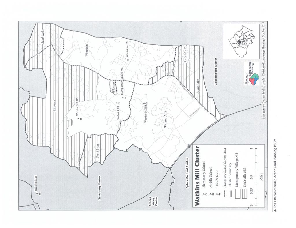
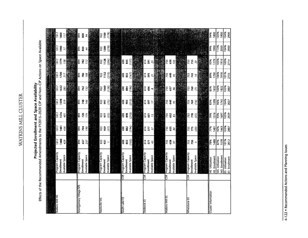
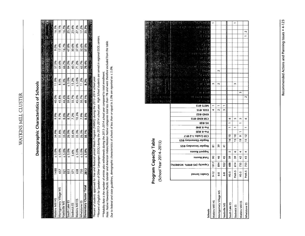
8 To increase compatibility, shorter sticks of townhomes are proposed, distances between homes are maximized and a large open green at the eastern entry is planned to create a sense of privacy between homes. These design features, which were requested by the community, help to strengthen the transition between existing and new neighborhoods. Final design of the amended development plan will be reviewed by the Montgomery County Planning Board at the time of subdivision and site plan review if the DPA is approved. The Applicant must submit a site plan in accordance with Section 59-D-3 of the Zoning Ordinance before any development of the site may take place. PUBLIC FACILITIES Transportation A traffic analysis has been prepared to demonstrate that the proposed project will not overburden the surrounding transportation system. For Local Area Transportation Review the proposed 86 singlefamily attached units generate 41 peak-hour trips within the weekday morning peak period (6:30 to 9:30 a.m.) and 71 peak-hour trips within the evening peak period (4:00 to 6:00 p.m.). A trip credit for the 18- hole golf course reduced the new site-generated trips by 3 peak-hour trips within the weekday morning peak period and 17 peak-hour trips within the evening peak period. Because the proposed development generates 30 or more total peak-hour trips within the weekday morning and evening peak periods, a traffic study was submitted by the Applicant for the originally proposed 84 townhomes. At the time of Preliminary Plan, the Applicant will need to update the traffic study to reflect a total of 86 townhomes if DPA is approved. (See Transportation Memo Attachment 4.) Schools The Property is located within the Watkins Mill High School cluster which currently has adequate capacity to accept new students at all grade levels. (See MCPS Memo Attachment 5.) Utilities Public water and sewer, electricity, telephone and cable currently serve the property and can be utilized for the proposed residential development. MASTER PLAN DPA involves a portion of a former golf course in Montgomery Village, which is located within the boundaries of the 1985 Gaithersburg Vicinity Master Plan. The Department is working on a new Master Plan for Montgomery Village, which was initiated in October The Planning Board approved the Scope of Work for the Montgomery Village Master Plan on December 11, The Staff Draft of the Montgomery Village Master Plan is tentatively scheduled to be presented to the Planning Board in June
9 Montgomery Village is a planned community that began developing in 1965 under the Town Sector Zone and its Development Plan, which were created to guide development for this large new town. Although the 1985 Gaithersburg Vicinity Master Plan encompassed a 25 square mile area, its focus was limited to three areas where there are meaningful opportunities to influence physical growth and future development through the master plan process (page 5) because the rest of the area has been developed or has received development approvals. (page 5) The Applicant did provide a detailed explanation of the 1985 Gaithersburg and Vicinity Master Plan that they believe provides guidance and support of the requested DPA. (See Attachment 6.) The 1985 Plan contained neither descriptive narrative nor any specific recommendations about Montgomery Village. With the exception of a reference to undeveloped school sites being retained for open space if they are not needed for schools, the 1985 Gaithersburg Vicinity Master Plan did not specifically address Montgomery Village. The following language regarding Montgomery Village school sites is from the 1985 Plan s Community Facilities chapter: Montgomery Village Recreation and Open Space Facilities (1980) Substantial recreation and park facilities are available to residents of Montgomery Village by virtue of automatic membership in the Montgomery Village Foundation. With the exception of school site facilities, all were built by the developer and are maintained, at no cost to the County, by the Montgomery Village Foundation. It is important that at least a portion of each undeveloped school site in the Village be transferred to the Montgomery Village Association for field sport recreation, if the site is not needed for school construction. For example, the ballfield site on Apple Ridge Road should be retained by the Association even if a portion of the site is ultimately used for non-school purposes. (page 95) General guidance regarding possible future development of privately owned open space in the master plan area is found in the 1985 Plan s Community Facilities chapter: Private Recreation Facilities in Developing Areas Housing developers have an obligation to see that the recreation needs of future residents are met by either existing or proposed public parkland, private recreation facilities within the development, or by dedication of land suitable for future park development. The development of private open space areas to service various age groups can be done relatively inexpensively by encouraging the provision of sitting areas, pathways, open play areas, and playgrounds in attractive open spaces. (page 95) The 1985 Plan s fold-out land use map had two open space categories: Parkland and Private Conservation/Recreation. The only site-specific guidance for the subject property is found on the foldout land use map, which identified the former golf course as Private Conservation/Recreation. Since the former golf course was labeled as Private Conservation/Recreation on the Plan s fold-out land use map, the Department has concluded that DPA is not consistent with the 1985 Gaithersburg Vicinity Master Plan. 9
10 TRANSPORTATION The following issues related to the Adequate Public Facilities (APF) test of the transportation requirements for the subject Local Map Amendment Application must be addressed at the relevant subsequent reviews if the DPA is approved: 1. The DPA should be limited to proposed 86 single-family attached units. 2. The Applicant must work with the Montgomery County Department of Transportation (MCDOT) regarding: a. Submission of a traffic signal warrant study at the intersection of Montgomery Village Avenue and Meadowcroft Lane, the proposed northernmost access. If a traffic signal installation is warranted, fund and install the traffic signal. b. Shifting the right-turn-in/right-turn-out at the site s southernmost Montgomery Village Avenue access as far south as feasibly possible to give motorists traveling north more distance to make a U-turn at Duffer Way (i.e., U-turns must merge and then cross two through lanes to get to the left-turn lane). c. Whether deceleration and acceleration lanes and a left-turn storage lane are necessary on Montgomery Village Avenue at the site s two proposed curb cuts. 3. At Preliminary Plan Review, the following will be required: a. Update the submitted traffic study to satisfy the Local Area Transportation Review (LATR) test at Preliminary Plan review to reflect the proposed 86 single-family attached units and update the traffic counts if they are more than 12 months old at Preliminary Plan review. DISCUSSION b. Satisfy the Transportation Policy Area Review test by paying the Montgomery County Department of Permitting Services (DPS) the transportation impact tax at the time of building permit. c. Construct a 5-foot wide sidewalk with a tree panel along the Arrowhead Road frontage. d. Provide bike racks at the required recreation area. Site Location and Vehicular Site Access Points The site is located between Montgomery Village Avenue and Arrowhead Road approximately 750 feet south of the intersection of these two roadways. Vehicular access points are proposed as follows: 1. A full movement access from Montgomery Village Avenue opposite of Meadowcroft Lane. 2. A southern right-turn-in/right-turn-out only access from Montgomery Village Avenue. This rightturn-in/right-turn-out must be shifted as far south as feasibly possible to give motorists traveling 10
11 north more distance to make a U-turn at Duffer Way (i.e., U-turns must merge and then cross two through lanes to get to the left-turn lane). 3. A full movement access from Arrowhead Road opposite of Rothbury Drive that will provide additional connectivity and improve site circulation between Arrowhead Road and Montgomery Village Avenue. Based on the submitted traffic data, the minimal additional traffic volume would not warrant the need for northbound deceleration/right-turn lanes on Montgomery Village Avenue at the two proposed site access points. A northbound left-turn lane on Arrowhead Road at the proposed site access would not be desirable because it would disrupt existing on-street parking and the site-generated left turns are minimal. Sector-Planned Roadways and Bikeway The 1985 Gaithersburg Vicinity Master Plan designated the following roadways and bikeways: 1. Montgomery Village Avenue is designated as a four-lane arterial, A-295, with a recommended 80-foot-wide right-of-way and a Class I bikeway, E-16. The current right-of-way is approximately 100 feet wide and is surrounded to its ultimate four-lane condition. 2. Arrowhead Road is designated as a primary residential street, P-19, with a recommended 70- foot-wide right-of-way and no bikeway. Arrowhead Road is constructed to its ultimate 36-foot condition with a combination of lanes and parking. The current right-of-way is approximately 70 feet wide. The 2005 Countywide Bikeways Functional Master Plan does not recommend any bikeways along Montgomery Village Avenue or Arrowhead Road. Public Transit Service Transit service is available from the proposed site along following two bus routes: 1. Ride-On route 58 operates along Montgomery Village Avenue with 30-minute headways between the Shady Grove Metrorail Station and the Lakeforest Mall Transit Center. 2. Ride-On route 64 operates along Arrowhead Road with 30-minute headways between the Shady Grove Metrorail Station and the Montgomery Village Center. Bus stops are located currently at the intersections of Montgomery Village Avenue/Meadowcroft Lane, Montgomery Village Avenue/Duffer Way, and Arrowhead Road/Rothbury Drive. Pedestrian and Bicycle Facilities Approximately 5-foot wide sidewalks with small green panels are already constructed along both sides of Montgomery Village Avenue. Along Arrowhead Road, only a 6-foot wide sidewalk with a 6-foot wide green panel exists on the opposite side of this road. At Preliminary Plan review, the Applicant must provide a sidewalk along the frontage of Arrowhead Road and bike racks at the site s recreational area. 11
12 Transportation Adequate Public Facilities Test Based on the submitted information, it is likely that the transportation APF tests for the Local Area Transportation Review (LATR) and Transportation Policy Area Review (TPAR) can be satisfied at Preliminary Plan review. For Local Area Transportation Review the proposed 86 single-family attached units generate 41 peakhour trips within the weekday morning peak period (6:30 to 9:30 a.m.) and 71 peak-hour trips within the evening peak period (4:00 to 6:00 p.m.) A trip credit for the 18-hole golf course reduced the new sitegenerated trips by 3 peak-hour trips within the weekday morning peak period and 17 peak-hour trips within the evening peak period. The Applicant submitted a traffic study to satisfy the LATR test based on the originally proposed 84 single-family attached units because the proposed development generates 30 or more total peak-hour trips within the weekday morning and evening peak periods. Based on the submitted traffic study, the table below shows the calculated Critical Lane Volume (CLV) values at the analyzed intersections for the following traffic conditions: 1. Existing: Existing traffic conditions as they exist now. 2. Background: The existing condition plus the trips generated from approved but un-built nearby developments and the I-270/Watkins Mill Road interchange that is fully-funded for construction. 3. Total: The background condition plus the site-generated trips. Analyzed Intersection Montgomery Village Avenue & Arrowhead Road-Shadow Oak Drive Montgomery Village Avenue & Apple Ridge Road-Hob Hill Way Montgomery Village Avenue & Meadowcroft Lane-Northern Access Montgomery Village Ave & Duffer Way Montgomery Village Avenue & Club House Road Arrowhead Road & Rothbury Drive Goshen Road & Rothbury Drive-Green Run Way Montgomery Village Avenue & Southern Right-Turn-In & Right- Turn-Out Access Weekday Peak Hour 12 Traffic Condition Existing Background Total Morning * 613* Evening * 766* Morning * 828* Evening * 910* Morning * 494* Evening * 484* Morning * 520* Evening * 497* Morning * 735* Evening * 933* Morning Evening Morning Evening Morning * 502* Evening * 475* *The CLV values in the background and total traffic conditions are reduced because the some of the existing traffic on Montgomery Village Avenue was diverted onto Watkins Mill Road traveling to/from I-270. The Maryland State Highway administration s Capital Transportation Program Project No. M for the I-270/Watkins Mill Road interchange is fully funded for construction and is projected to open to traffic within five years.
13 As shown on the table above, the CLV values at the eight intersections are less than the CLV/congestion standard of 1,425 for the Montgomery Village/Airpark Policy Area. The increase from the analyzed 84 single-family attached units to the currently proposed 86 units is only a 2.4% increase in traffic and will not result in the analyzed intersections approaching 1,425 CLV standard, therefore, the LATR test is satisfied for the subject DPA. For Transportation Policy Area Review, the Applicant must satisfy the TPAR test at Preliminary Plan review by paying 25% of the transportation impact tax for the single-family attached residential units located in the Montgomery Village/Airpark Policy Area. For the current TPAR test, the roadway test for this policy area is adequate, and the transit test is inadequate. The TPAR mitigation payment/ transportation impact tax is paid to DPS at the time of building permit. ENVIRONMENT As submitted, the plans for the DPA are not in compliance with the Montgomery County Planning Department s Environmental Guidelines, due especially to the presence of a mapped FEMA 100-year floodplain on the site. This issue is addressed in the conditions of approval for the Preliminary Forest Conservation Plan (PFCP) that accompanies the DPA. This issue and others are covered in the separate staff report for the PFCP. Approval of the PFCP will also address conditions for compliance with Chapter 22A. COMMUNITY OUTREACH The Application was submitted and noticed in accordance with all required procedures. The Application met posting requirements with two signs. Staff has received several letters in opposition to DPA 15-01, including requests that the application be postponed until the Town Sector Zones have been changed through the on-going Master Plan study to be consistent with the current County Zoning Ordinance. (See Attachment 7) The Applicant has engaged in a 12-month community outreach effort, including a series of community design workshops with the entire Montgomery Village community from May through November of 2013, and ongoing coordination with the Montgomery Village Foundation (MVF) subsequent to those workshops. The MVF formed a special committee, the Joint Property Committee (JPC) to review, analyze and comment upon the Applicant s redevelopment plans for the Property, as well as the entire Concept Plan. The members of the JPC were comprised of members of the HOA Boards that border the golf course, community residents with relevant professional experience, and leadership from the MVF Board. After nearly a year of deliberations and resulting revisions to the Concept Plan, the JPC voted unanimously to support the proposed Concept Plan, which included the Property in question. The Foundation Board followed suit with an 8-1 vote to approve of the Concept Plan in March According to the Applicant, five workshops to which all residents of Montgomery Village were invited have been conducted. Over the course of the year, over 200 different people attended the events and were able to provide feedback and have their questions answered by the Applicant and its design team. In addition, through 2013 and most of 2014, the Applicant had a booth at the local Farmer s Market and 13
14 numerous community events, gave public tours around the perimeter of the golf course, and visited with neighbors in their kitchens and backyards. Finally, the Applicant set up a website with information about the Concept Plan, which has garnered hundreds of unique visitors. As a result of this outreach, the Applicant is pleased to have the support of many of the neighbors of the Property and the MVF leadership. Attached is a Resolution approved and adopted by the Board of Directors of the MVF in support of DPA (see Attachment 8). EVALUATION AND FINDINGS Sec. 59-C-7.2., T-S, Town Sector Zone It is the purpose of this zone to provide a classification which will permit development of or additions to planned new towns or additions to existing urban developments. Such towns shall contain, insofar as possible, all of the residential, commercial, community and industrial facilities needed to make possible a town that is reasonably self-sufficient for all purposes, except major employment and central business district shopping. Adequate provision shall be made for the maintenance of open space and the location of streets and highways to assure orderly traffic circulation. Provision shall be made for the inclusion of housing for families of low and moderate incomes. Physical planning within the town shall be such as to assure that these uses, including a wide variety of types of housing accommodations, shall be placed in efficient and orderly relationship. A new town is further described, for the purposes of this chapter, as being located on a substantially undeveloped site and meeting the following mutually interdependent requirements: (a) (b) (c) (d) (e) Self-Sufficiency. Containing as nearly as possible all of the commercial, employment, cultural and recreational facilities desirable and necessary for the satisfaction of the needs of its residents. Diversity. Containing a wide variety of residential facilities, so as to offer a wide range of structural types, site planning layouts and arrangements, and rental and purchase prices. Density. Urban rather than rural, in order to facilitate travel between residential, commercial, employment and other types of areas and to make the most efficient use of public utilities, but low enough to permit the incorporation of large amounts of open land within the town for recreational and scenic purposes. Transportation Facilities. Transportation facilities adequate to serve the anticipated total population shall be either in existence or planned for future construction. Public Utilities. Public sewer and water shall be available at the site or planned for construction. Land lying principally within a corridor city as defined in section 59-A-2.1, title "Definitions," may be considered for classification in the town sector zone. In order to encourage and facilitate desirable development of this kind, it is further the purpose to eliminate, in the town sector zone, some of the specific restrictions which regulate, in other zoning 14
15 categories, the height, bulk and arrangement of buildings and the location of the various land uses; to provide for more flexibility in development; and to require that all development be in accordance with a plan meeting the requirements of this section, and the development plan provisions of division 59-D-1. It is the intent of this zone to achieve flexibility of design, integration of mutually compatible uses and optimum land planning with greater efficiency, convenience and amenity than the standards permitted by right and required in conventional zoning categories. In addition, it is the purpose of this zone to preserve and take the greatest possible aesthetic advantage of trees; and, in order to do so, minimize the amount of grading necessary for construction of a development. The fact that an application complies with all specific requirements and purposes set forth herein shall not be deemed to create a presumption that the application is, in fact, compatible with surrounding land uses and, in itself, shall not be sufficient to require the granting of any application. DPA is an addition to the existing planned community created by the original development plan. The layout of open spaces and streets is designed to ensure orderly circulation throughout the proposed neighborhood, but also to have a minimal impact on the surrounding communities. The three access points allow the disbursement of traffic along Montgomery Village Avenue and Arrowhead Road, minimizing the pressure on both streets and allowing residents options in navigating to and from the community. In addition, the circular design of the private road and the on-street parking combine to minimize speeds, while the alleys minimize the number of curb cuts and, therefore, vehicular conflicts with cyclists and pedestrians. In addition, MPDUs, per County law, are provided for to accommodate families of moderate income. Finally, the design of the new community is based on complementing and interacting with the existing community to create an efficient and orderly relationship with the surrounding neighborhoods and Montgomery Village generally. 59-C Limitations No property shall be placed in a town sector zone, except upon application of a person with a financial, contractual or proprietary interest in the property, notwithstanding any provisions of this chapter to the contrary. Not applicable. 59-C Land uses. Uses described on the approved development plan, as provided in division 59-D-1, shall be permitted by right in this zone. All uses authorized in any zone, by right or as special exceptions, may be similarly authorized in the town sector zone, subject to the following restrictions: 59-C Only uses shown on the approved site plan shall be permitted, unless the site plan is first amended in accordance with the requirements of division 59-D-3. An amendment to the site plan shall not be required for construction of accessory buildings and additions or modifications to existing one-family detached dwelling units or townhouses and accessory buildings if: 15
16 (a) (b) The planning board has approved homeowners association documents establishing a procedure to review such development prior to said construction; and Under this procedure, approval for said construction has been granted; provided, however, that site plan review is necessary for additional construction commenced prior to December 9, 1980, if: (1) At the time such additional construction was commenced, site plan review was required; and (2) The recorded subdivision plat creating the lot upon which such development is proposed did not indicate the standards to be applied or the procedures to be followed to approve additional construction beyond initial development. Planning Board approval of a Preliminary Plan and Site Plan will be required if DPA is approved by the District Council. 59-C No use shall occupy a location other than indicated on the approved site plan. Planning Board approval of a Preliminary Plan and Site Plan will be required if DPA is approved by the District Council. 59-C Areas designated as residential on the development plan, shall consist of the residential portion of the town sector zone and accompanying facilities such as local retail areas, public school sites, local recreational and open space areas and public roads. Only the following uses shall be permitted in residential areas: (a) One-family dwellings, which shall be used only for the following purposes: (1) Dwelling for one family. Only residential uses (townhouses) are proposed, along with open spaces and private streets, similar to other residential areas in Montgomery Village. (2) Professional offices for use by not more than one member of a recognized profession who is a resident of the dwelling and by not more than one nonresident assistant. Recognized professions include but are not limited to medicine, dentistry, law, accounting and architecture; they do not include businesses such as insurance, real estate, etc. A professional office in this instance shall be incidental to the principal use of the building as a dwelling and shall not include a medical, dental or veterinary clinic or in-patient treatment facility. Not applicable. (3) All other uses permitted in the R-90 zone, as shown in section 59-C Not applicable. 16
17 (4) All uses permitted as special exceptions in the R-90 zone, as shown in section 59-C-1.31, subject to the grant of a special exception in accordance with article 59-G. Not applicable. (b) Multiple-family dwellings, which shall be used only for the following purposes: (1) Dwelling units, not more in number than shown on the site plan. (2) Office for rental, operation, service and maintenance of a multiple- family dwelling or group of dwellings. (3) All other uses permitted in the R-30 zone, as shown in section 59-C-2.3. (4) All uses permitted as special exceptions in the R-30 zone, as shown in section 59-C-2.3 subject to the grant of a special exception in accordance with article 59-G. (5) Any of the commercial uses permitted in the C-1 zone; provided that: (i) (ii) There shall be no dwelling units on any floor on which there are commercial uses; and The total floor area used for commercial purposes shall be no greater than shown on the site plan. Not applicable. (c) Housing and related facilities for senior adults and persons with disabilities. Not applicable. 59-C Privately owned roads and community open spaces. Privately owned roads and community open spaces may be held in perpetuity by the developer or by an approved homes association, substantial in membership and duration, provided that easements for such uses shall be granted to the county and recorded in the land records of the county following planning board approval of such easements. The attached draft Homeowner s Association (HOA) documents provide for the ownership of the private roads and community open spaces in perpetuity. 59-C Area requirements. 59-C Minimum area of tract. Each application for the town sector zone shall be for a tract of land which has an area of 1,500 acres or more; except, that an application for a tract of any size adjoining a tract in the town sector zone may be filed by the original applicant or a successor in title. Montgomery Village consists of 2,435 acres; the proposed DPA does not change the acreage. 17
18 59-C Rooftop mounted antennas and related unmanned equipment building, equipment cabinets, or equipment room may be installed under the guidelines contained in Sec. 59-A Not applicable. 59-C Commercial area. Not more than 10 percent of the total area of the town sector may be devoted to commercial purposes. All required parking for commercial purposes shall be included within the 10 percent calculation. Not applicable; the proposed DPA does not make any changes to the commercial areas. 59-C Industrial area. Not more than 6 percent of the total area of the town sector zone may be devoted to industrial purposes and other major employment facilities. Not applicable; the proposed DPA does not make any changes to the industrial areas. 59-C Open space. Not less than 10 percent of the total area of the town sector zone shall be devoted to open space. This may include publicly owned, community-wide or common open space and facilities but may not include streets and parking areas. Open space makes up 28.62% of the total area of Montgomery Village. The proposed DPA does not make any changes to the amount of open space. The former golf course is not included as part of the open space. 59-C Density of population. The population of the town sector zone must be planned so as not to exceed 15 persons per acre based upon the total area within the town sector zone; except, that such planned population may be increased by an amount equal to the population to be housed in moderately priced dwelling units included in the development plan in accordance with chapter 25A of this Code, as amended, provided that the total increase in population does not exceed 22 percent of the population that would otherwise be permitted. In calculating the density, the following standards shall apply: (a) One-family detached dwellings shall be assumed to have an average occupancy of 3.7 persons. (b) (c) (d) Townhouses shall be assumed to have an average occupancy of 3 persons. Multiple-family dwellings less than 5 stories in height shall be assumed to have an average occupancy of 3 persons per dwelling unit. Multiple-family dwellings 5 stories in height or higher shall be assumed to have an average occupancy of 2 persons per dwelling unit. 18
19 As previously noted, 232 population credits remain available within Montgomery Village. Application of the ratio above for townhouse development permits 77 townhouse units, exclusive of MPDUs. Eightysix units are proposed: 75 market rate and 11 MPDUs (the MPDUs are excluded from the density calculation). 59-C Height. The heights of all buildings in the town sector zone shall be consistent with the limitations set in other zoning classifications for areas of similar density or similar use. The height of individual buildings will be established during Site Plan if the DPA is approved. The DPA application shows 3-story townhouses at a maximum height of 40 feet. The TLD and TMD Zones (Townhouse Low Density and Townhouse Medium Density, respectively) allow heights up to 40 feet for optional method developments and will serve as a model for this project at site plan. 59-C Utilities. (a) (b) All utility lines in the town sector zone shall be placed underground. The developer shall ensure final and proper completion and installation of utility lines as provided in the subdivision regulations, being section 50-40(c) of this Code. Standards for street lighting shall be provided by the developer in accordance with the approved site plan. No use-and-occupancy permit shall be issued for any building which is not served by an approved sewer and water supply. All utility lines will be placed underground and in accordance with the subdivision and other County regulations. Street lighting shall be considered at site plan. The proposed development will be served by public water and sewer, to be evaluated in detail at the time of subdivision. 59-D Approval by District Council 59-D Findings Before approving an application for classification in any of these zones, the district council must consider whether the application, including the development plan, fulfills the purposes and requirements set forth in article 59-C for the zone. In so doing, the district council must make the following specific findings, in addition to any other findings which may be necessary and appropriate to the evaluation of the proposed reclassification: (a) That the zone applied for is in substantial compliance with the use and density indicated by the master plan or sector plan, and that it does not conflict with the general plan, the county capital improvements program or other applicable county plans and policies. The proposed DPA is inconsistent with the 1985 Gaithersburg Vicinity Master Plan. The Applicant must show that the proposed Development Plan Amendment is in substantial compliance with the use and density requirements of the Master Plan. The 1985 Gaithersburg Vicinity Master Plan contains no narrative or background about 19
20 Montgomery Village, but the Land Use Plan associated with the Master Plan, designates this property as Private Conservation/Recreation ; therefore, the proposed amendment for residential townhouse development on this site is not consistent with the land use plan recommendations of the current Master Plan. (b) That the proposed development would comply with the purposes, standards, and regulations of the zone as set forth in article 59-C, would provide for the maximum safety, convenience, and amenity of the residents of the development and would be compatible with adjacent development. The application is consistent with the density regulations of the T-S Zone. However, as noted above, DPA is inconsistent with the Gaithersburg Vicinity Master Plan. Therefore, the purpose clause for the T-S Zone is not fully satisfied. The Applicant believes that the proposed project provides for the maximum safety, convenience, and amenity of the residents of the development and that it is a welldesigned site plan, within walking distance of the existing commercial center. Parking is provided in garages, in driveways and on the street to maximize the opportunities for residents and guests to gather at a home and prevent spillover parking. (c) That the proposed internal vehicular and pedestrian circulation systems and points of external access are safe, adequate, and efficient. The external access points are safe and efficient, with crosswalks proposed to assist pedestrians and bicyclists out of the community. Pedestrian circulation was a major focus of the design and sidewalks are provided throughout, and alleys serving most of the units remove potential vehicular conflicts from the main road. (d) That by its design, by minimizing grading and by other means, the proposed development would tend to prevent erosion of the soil and to preserve natural vegetation and other natural features of the site. Any applicable requirements for forest conservation under Chapter 22A and for water resource protection under Chapter 19 also must be satisfied. The district council may require more detailed findings on these matters by the planning board at the time of site plan approval as provided in division 59-D-3. The proposed townhouses have been developed to cluster homes around alleys and along streets to minimize impacts and an overly large limit of disturbance. This will minimize the need for grading beyond the building and buffers between the existing and proposed units. All of the graded areas, however, will be stabilized as required through subsequent sediment and erosion control plans. Finally, these graded areas will be designed with minimal slopes and with ample vegetation to prevent erosion; this is further aided through the dispersion of stormwater management into smaller drainage areas than was allowed when most of Montgomery Village developed under the T-S Zone. 20
21 (e) That any documents showing the ownership and method of assuring perpetual maintenance of any areas intended to be used for recreational or other common or quasi-public purposes are adequate and sufficient. The draft Homeowner s Association (HOA) documents provided establish a mechanism for perpetual maintenance of the common areas. CONCLUSION The proposal complies with the relevant sections of the Montgomery County Zoning Ordinance, except master plan compliance. Since a Montgomery Village Master Plan is underway, staff believes that the public interest would be better served if land use decisions are made through this comprehensive process and that the Hearing Examiner should postpone the public hearing for a reasonable period of time. Therefore, Staff recommends deferral/denial of DPA ATTACHMENTS ATTACHMENT 1 Letter from Maryland Department of Natural Resources ATTACHMENT 2 Development History in Montgomery Village ATTACHMENT 3 Density Plan ATTACHMENT 4 Transportation Planning Memo ATTACHMENT 5 Montgomery County Public Schools Memo ATTACHMENT 6 Letter from Applicant Regarding Master Plan ATTACHMENT 7 Opposition Letters to DPA ATTACHMENT 8 Montgomery Village Foundation Resolution and Letters in Support of DPA
22
23

24
25
26
27

28
29
30

31
32
33
34
35
36
37
38
39
40
41
42
43
44
45
46

47
48
49
50
51
52
53
54
55
56
57
MONTGOMERY COUNTY PLANNING DEPARTMENT THE MARYLAND-NATIONAL CAPITAL PARK AND PLANNING COMMISSION
 MONTGOMERY COUNTY PLANNING DEPARTMENT THE MARYLAND-NATIONAL CAPITAL PARK AND PLANNING COMMISSION MCPB Item No. Date: 12/4/14 Preliminary Plan No. 120140200, Northwood Knolls Description Patrick Butler,
Article Zones Retained From Previous Ordinance
 Article 59-9. Zones Retained From Previous Ordinance DIV. 9.1. IN GENERAL Sec. 9.1.1. applicability... 9 2 Sec. 9.1.2. Modification of zones... 9 2 DIV. 9.2. RESIDENTIAL FLOATING ZONES Sec. 9.2.1. zones
MONTGOMERY COUNTY PLANNING DEPARTMENT THE MARYLAND-NATIONAL CAPITAL PARK AND PLANNING COMMISSION
 MONTGOMERY COUNTY PLANNING DEPARTMENT THE MARYLAND-NATIONAL CAPITAL PARK AND PLANNING COMMISSION MCPB Item No. 8 Date: 03-07-13 Sonoma, Preliminary Plan, 120130040 Melissa Williams, Senior Planner, Melissa.williams@montgomeryplanning.org,
CREEKSIDE TOWNHOMES Chevy Chase, Maryland Site Plan No Preliminary Plan No
 +1 (301) 656 5901 info@nova-habitat.com CREEKSIDE TOWNHOMES Chevy Chase, Maryland Site Plan No. 820160050 Preliminary Plan No. 120160130 Application Statement of Justification October 28, 2015 Nova-Habitat,
Draft Zoning Changes for the 2nd Planning Board Public Hearing, January 22, 2018.
 Draft Zoning Changes for the 2nd Planning Board Public Hearing, January 22, 2018. No changes were made at the 1st Public Hearing. Proposed wording for the 1 st Public Hearing in red, eliminated text in
9. REZONING NO Vicinity of the northwest corner of 143 rd Street and Metcalf Avenue
 9. REZONING NO. 2002-15 Vicinity of the northwest corner of 143 rd Street and Metcalf Avenue 1. APPLICANT: Andrew Schlagel is the applicant for this request. 2. REQUESTED ACTION: The applicant is requesting
MONTGOMERY COUNTY PLANNING DEPARTMENT THE MARYLAND-NATIONAL CAPITAL PARK AND PLANNING COMMISSION
 MONTGOMERY COUNTY PLANNING DEPARTMENT THE MARYLAND-NATIONAL CAPITAL PARK AND PLANNING COMMISSION MCPB Item No. 3 Date: 01-31-13 Preliminary Plan 120090300, Boyds Highlands Calvin Nelson, Jr. Planner Coordinator,
MONTGOMERY COUNTY PLANNING DEPARTMENT THE MARYLAND-NATIONAL CAPITAL PARK AND PLANNING COMMISSION
 MONTGOMERY COUNTY PLANNING DEPARTMENT THE MARYLAND-NATIONAL CAPITAL PARK AND PLANNING COMMISSION MCPB Item No.: Date: 11-12-15 15931 Frederick Road (CarMax) Annexation Request ANX2015-00145 Patrick Butler,
MONTGOMERY COUNTY PLANNING DEPARTMENT THE MARYLAND-NATIONAL CAPITAL PARK AND PLANNING COMMISSION
 MONTGOMERY COUNTY PLANNING DEPARTMENT THE MARYLAND-NATIONAL CAPITAL PARK AND PLANNING COMMISSION MCPB Item No. Date: 12/6/12 Limited Site Plan Amendment, 82000018D, DANAC Stiles Property, Lot 6 of Block
City and County of Broomfield, Colorado
 City and County of Broomfield, Colorado CITY COUNCIL AGENDA MEMORANDUM To: From: Mayor and City Council George Di Ciero, City and County Manager Teri Malies, Principal Planner Terrance Ware, Planning Director
Article Optional Method Requirements
 Article 59-6. Optional Method Requirements [DIV. 6.1. MPDU DEVELOPMENT IN RURAL RESIDENTIAL AND RESIDENTIAL ZONES Sec. 6.1.1. General Requirements... 6 2 Sec. 6.1.2. General Site and Building Type Mix...
PLANNED UNIT DEVELOPMENT & SUBDIVISION STAFF REPORT Date: April 18, 2019
 PLANNED UNIT DEVELOPMENT & SUBDIVISION STAFF REPORT Date: April 18, 2019 DEVELOPMENT NAME SUBDIVISION NAME Springhill Village Subdivision Springhill Village Subdivision LOCATION 4350, 4354, 4356, 4358,
MONTGOMERY COUNTY PLANNING DEPARTMENT THE MARYLAND-NATIONAL CAPITAL PARK AND PLANNING COMMISSION
 MONTGOMERY COUNTY PLANNING DEPARTMENT THE MARYLAND-NATIONAL CAPITAL PARK AND PLANNING COMMISSION MCPB Item No. Date: 05-30-13 Pre-Preliminary Plan No. 720130040: Potomac Highlands Callum Murray, supervisor,
MONTGOMERY COUNTY PLANNING DEPARTMENT THE MARYLAND-NATIONAL CAPITAL PARK AND PLANNING COMMISSION
 MONTGOMERY COUNTY PLANNING DEPARTMENT THE MARYLAND-NATIONAL CAPITAL PARK AND PLANNING COMMISSION Colesville Senior Living Facility, Limited Preliminary Plan Amendment, 12016011A MCPB Consent Item Date:
Article Floating Zone Requirements
 Division 5.1. In General Article 59-5. Floating Zone Requirements Section 5.1.1. Zone Categories There are 4 categories of Floating zones: A. Residential Floating zones (Division 5.2); B. Commercial/Residential
TOTTENHAM SECONDARY PLAN
 TOTTENHAM SECONDARY PLAN AMENDMENT NO. 11 TO THE OFFICIAL PLAN OF THE TOWN OF NEW TECUMSETH The following text and schedules to the Official Plan of the Town of New Tecumseth constitute Amendment No. 11
Open Space Model Ordinance
 Open Space Model Ordinance Section I. Background Open space development has numerous environmental and community benefits, including: 1) Reduces the impervious cover in a development. Impervious cover
ARTICLE OPTIONAL METHOD REGULATIONS
 ARTICLE 59-6. OPTIONAL METHOD REGULATIONS DIV. 6.1. MPDU DEVELOPMENT IN RURAL RESIDENTIAL AND RESIDENTIAL ZONES SEC. 6.1.1. GENERAL REQUIREMENTS... 6 2 SEC. 6.1.2. GENERAL SITE AND BUILDING T PE MIX...
REPORT TO THE SHELBY COUNTY PLANNING COMMISSION From the Department of Development Services Planning Services. February 4, 2019
 REPORT TO THE SHELBY COUNTY PLANNING COMMISSION From the Department of Development Services Planning Services February 4, 2019 Case No. Request for Rezoning Approval From E-1 to E-2 SD This is a request
ARTICLE FIVE FINAL DRAFT
 ARTICLE FIVE 021218 FINAL DRAFT Sec. 503.6 Open Space Preservation Option Open Space Preservation Option Open Space Preservation developments may be approved in the AR, R-1, R-2 and R-3 zoning districts,
ARTICLE 23 CONDOMINIUM STANDARDS
 ARTICLE 23 CONDOMINIUM STANDARDS Section 23.01 Intent. The intent of this Article is to provide regulatory standards for condominiums and site condominiums similar to those required for projects developed
Montgomery Village - South Valley Park: Subdivision Regulation Waiver SRW , and Site Plan No
 Montgomery Village - South Valley Park: Subdivision Regulation Waiver SRW - 201402, and Site Plan No. 820140070 12 SUBDIVISION REGULATION WAIVER RECOMMENDATION AND CONDITIONS OF APPROVAL Staff recommends
WHEREAS, the staff of The Maryland-National Capital Park and Planning Commission recommended APPROVAL of the application with conditions; and
 R E S O L U T I O N WHEREAS, Redeemed Christian Church of God is the owner of a 2.83-acre parcel of land known as Lot 9, Lot 19, P/O Lot 1 and P/O Lot 18, Block B, Plat Book A, Plat 5, said property being
MONTGOMERY COUNTY PLANNING BOARD
 MONTGOMERY COUNTYPLANNING BOARD T H E MARYLAND-NATIONAL CAPITAL PARK A N D P L A N N I N G C O M M I S S I O N MCPB NO. 10-100 Preliminary Plan No. 120100210 Date of Hearing: July 1, 2010 MONTGOMERY COUNTY
WRITTEN DECISION OF THE HAYDEN CITY COUNCIL REGARDING MAPLE GROVE PRELIMINARY SUBDIVISION APPLICATION (SUB-0013) HAYDEN SIGNATURE, LLC
 HAYDEN SIGNATURE, LLC") WRITTEN DECISION OF THE HAYDEN CITY COUNCIL REGARDING MAPLE GROVE PRELIMINARY SUBDIVISION APPLICATION (SUB-0013) HAYDEN SIGNATURE, LLC Application of Hayden Signature, LLC, an Idaho limited liability company,
WRITTEN DECISION OF THE HAYDEN CITY COUNCIL REGARDING MAPLE GROVE PRELIMINARY SUBDIVISION APPLICATION (SUB-0013) HAYDEN SIGNATURE, LLC Application of Hayden Signature, LLC, an Idaho limited liability company,
ARTICLE C. ZONING TEXT, DISTRICT CLASSIFICATIONS AND BOUNDARIES
 ARTICLE C. ZONING TEXT, DISTRICT CLASSIFICATIONS AND BOUNDARIES Sec. 10-2054. ZONING TEXT, DISTRICT CLASSIFICATIONS AND BOUNDARIES. In order to regulate the location of structures, the height and bulk
RC ; Reclassification The Garrison at Stafford Proffer Amendment (formerly Stafford Village Center)
") Board of Supervisors Robert Bob Thomas, Jr., Chairman Laura A. Sellers, Vice Chairman Meg Bohmke Jack R. Cavalier Wendy E. Maurer Paul V. Milde, III Gary F. Snellings Anthony J. Romanello, ICMA CM County
Board of Supervisors Robert Bob Thomas, Jr., Chairman Laura A. Sellers, Vice Chairman Meg Bohmke Jack R. Cavalier Wendy E. Maurer Paul V. Milde, III Gary F. Snellings Anthony J. Romanello, ICMA CM County
MONTGOMERY COUNTY PLANNING DEPARTMENT THE MARYLAND-NATIONAL CAPITAL PARK AND PLANNING COMMISSION
 MONTGOMERY COUNTY PLANNING DEPARTMENT THE MARYLAND-NATIONAL CAPITAL PARK AND PLANNING COMMISSION MCPB Item No.: Date: 06-21-12 The Plantations, Preliminary Plan -120090240 Benjamin Berbert, Senior Planner,
RECOMMENDATION: Approval subject to the following conditions:
 RECOMMENDATION: Approval subject to the following conditions: 1) Approval under this preliminary plan is limited to 2 lots for 2 dwelling units 2) The record plat must note that the preliminary plan is
DANAC Stiles Property. Preliminary Plan A
 DANAC Stiles Property Preliminary Plan 11996112A Vicinity Located in the LSC North District of the GSSC Master Plan. Adjacent Uses North: Single-family attached townhouses, R-60 zone; East: Office building,
SUBDIVISION, PLANNED UNIT DEVELOPMENT, ZONING AMENDMENT, & SIDEWALK WAIVER STAFF REPORT Date: July 19, 2018
 SUBDIVISION, PLANNED UNIT DEVELOPMENT, ZONING AMENDMENT, & SIDEWALK WAIVER STAFF REPORT Date: July 19, 2018 NAME SUBDIVISION NAME LOCATION West Mobile Properties, LLC U.S. Machine Subdivision 556, 566,
Chapter Planned Residential Development Overlay
 Chapter 19.29 Planned Residential Development Overlay Sections 010 Purpose 020 Scope 030 Definitions 030 Minimum Size 040 Allowable Uses 050 Minimum Development Standards 060 Density Bonus 070 Open Space
The following regulations shall apply in the R-E District:
 "R-E" RESIDENTIAL ESTATE DISTRICT (8/06) The following regulations shall apply in the R-E District: 1. Uses Permitted: The following uses are permitted. A Zoning Certificate may be required as provided
City of Grande Prairie Development Services Department
 City of Grande Prairie Development Services Department COUNTRYSIDE SOUTH OUTLINE PLAN Prepared by: GPEC Consulting Ltd. #202, 10712-100th Street Grande Prairie, AB Council Resolution of August 20, 2001
CITY COUNCIL STUDY SESSION MEMORANDUM
 City and County of Broomfield, Colorado To: From: Prepared by: Owner Applicant Property Size Property Location: CITY COUNCIL STUDY SESSION MEMORANDUM Mayor and City Council Charles Ozaki, City and County
To: Planning and Zoning Commission Anna Bertanzetti, Planning Director Alice Hanson, Senior Planner
 To: Planning and Zoning Commission From: Anna Bertanzetti, Planning Director Alice Hanson, Senior Planner Meeting Date Agenda Category Agenda Item # June 26, 2017 Business 4.b 1. Public Hearing on a Proposed
RECOMMENDATION Following the public hearing, consider Zoning Case PD14-16, with a Development Plan.
 Staff Report Zoning Case PD14-16 (Helzer Tract) Planning and Zoning Meeting Date: 12-17-14 Document Being Considered: Ordinance RECOMMENDATION Following the public hearing, consider Zoning Case PD14-16,
DEPARTMENT OF COMMUNITY PLANNING, HOUSING AND DEVELOPMENT Planning Division
 DEPARTMENT OF COMMUNITY PLANNING, HOUSING AND DEVELOPMENT Planning Division #1 Courthouse Plaza, 2100 Clarendon Boulevard, Suite 700 Arlington, VA 22201 TEL 703.228.3525 FAX 703.228.3543 www.arlingtonva.us
MAYOR AND CITY COUNCIL OF LAUREL DEPARTMENT OF ECONOMIC AND COMMUNITY DEVELOPMENT
 MAYOR AND CITY COUNCIL OF LAUREL DEPARTMENT OF ECONOMIC AND COMMUNITY DEVELOPMENT 8103 Sandy Spring Road Laurel, Maryland 20707 (301) 725-5300 Web: http://www.citvoflaurel.orq E-mail: ecd laurel.md.us
ARTICLE 12 PLANNED UNIT DEVELOPMENT DISTRICTS (PUDS) Sec Intent CHARTER TOWNSHIP OF BRIGHTON ZONING ORDINANCE
 Sec Intent CHARTER TOWNSHIP OF BRIGHTON ZONING ORDINANCE") ARTICLE 12 PLANNED UNIT DEVELOPMENT DISTRICTS (PUDS) Sec. 12-01 Intent 1 2 (a) The intent of this Article is to permit the coordinated development on larger sites, protect significant natural features
ARTICLE 12 PLANNED UNIT DEVELOPMENT DISTRICTS (PUDS) Sec. 12-01 Intent 1 2 (a) The intent of this Article is to permit the coordinated development on larger sites, protect significant natural features
Marion County Board of County Commissioners
 Marion County Board of County Commissioners Date: 12/29/2015 P&Z: 12/28/2015 BCC: 1/12/2016 Item Number 160113Z Type of Application Rezoning Request From: A-1 (General Agriculture) To: PUD (Planned Unit
JUSTIFICATION STATEMENT FOR PRELIMINARY PLAN NO Preliminary Plan Justification for Chevy Chase Lake
 I. INTRODUCTION JUSTIFICATION STATEMENT FOR PRELIMINARY PLAN NO. 120150130 Preliminary Plan Justification for Chevy Chase Lake Applicant, CC Associates LLC (the Applicant ), by its attorneys, Linowes and
Planned Residence District (PR) To review a plan to construct 11 single family homes on approximately 4.01 acres.
 To review a plan to construct 11 single family homes on approximately 4.01 acres.") STAFF REPORT PLANNING & ZONING COMMISSION Village Green Municipal Building, Council Chambers 47 Hall Street Wednesday, March 13, 2019 7:00 P.M. 1. FINAL DEVELOPMENT PLAN REVIEW Applicant: Romanelli and
STAFF REPORT PLANNING & ZONING COMMISSION Village Green Municipal Building, Council Chambers 47 Hall Street Wednesday, March 13, 2019 7:00 P.M. 1. FINAL DEVELOPMENT PLAN REVIEW Applicant: Romanelli and
OPEN SPACE RESIDENTIAL DEVELOPMENT (OSRD) MODEL SITE PLAN BYLAW
 MODEL SITE PLAN BYLAW") OPEN SPACE RESIDENTIAL DEVELOPMENT (OSRD) MODEL SITE PLAN BYLAW 1) PURPOSE AND INTENT a) The Primary Purposes for OSRD are the following: i) To allow for greater flexibility and creativity in the design
OPEN SPACE RESIDENTIAL DEVELOPMENT (OSRD) MODEL SITE PLAN BYLAW 1) PURPOSE AND INTENT a) The Primary Purposes for OSRD are the following: i) To allow for greater flexibility and creativity in the design
Conditional Use Permit case no. CU 14-06: Bristol Village Partners, LLC
 PLANNING AND ZONING COMMISSION STAFF REPORT August 7, 2014 Conditional Use Permit case no. CU 14-06: Bristol Village Partners, LLC CASE DESCRIPTION: LOCATION: LEGAL DESCRIPTION: EXISTING LAND USE: ZONING:
POLK COUNTY DEVELOPMENT REVIEW COMMITTEE CASE OVERVIEW
 POLK COUNTY DEVELOPMENT REVIEW COMMITTEE CASE OVERVIEW DRC Date: January 10, 2019 Level of Review: 4 PC Date: March 6, 2019 Type: Text Amendments BoCC Date: May 7, 2019 July 2, 2019 Case Numbers: Case
Initial Project Review
 Pierce County Department of Planning and Land Services, 2401 South 35th Street, Tacoma, WA (253) 798-7037 Initial Project Review Major Amendment to Preliminary Plat: Hawks Ridge Division 1 Application
Town of Cary, North Carolina Rezoning Staff Report 14-REZ-31 Cary Park PDD Amendment (Waterford II) Town Council Meeting January 15, 2015
 Town Council Meeting January 15, 2015") Town of Cary, North Carolina Rezoning Staff Report 14-REZ-31 Cary Park PDD Amendment (Waterford II) Town Council Meeting January 15, 2015 REQUEST To amend the Town of Cary Official Zoning Map by amending
Town of Cary, North Carolina Rezoning Staff Report 14-REZ-31 Cary Park PDD Amendment (Waterford II) Town Council Meeting January 15, 2015 REQUEST To amend the Town of Cary Official Zoning Map by amending
PLANNING COMMISSION STAFF REPORT. Merrimac PLNSUB Planned Development 38 West Merrimac November 9, Request. Staff Recommendation
 PLANNING COMMISSION STAFF REPORT Merrimac PLNSUB2011-00374 Planned Development 38 West Merrimac November 9, 2011 Planning and Zoning Division Department of Community and Economic Development Applicant:
Planning Department Oconee County, Georgia
 Planning Department Oconee County, Georgia STAFF REPORT REZONE CASE #: 6985 DATE: October 31, 2016 STAFF REPORT BY: Andrew C. Stern, Planner APPLICANT NAME: Williams & Associates, Land Planners PC PROPERTY
M-43 CORRIDOR OVERLAY ZONE
 ARTICLE 26.00 M-43 CORRIDOR OVERLAY ZONE Section 26.01 Findings A primary function of the M-43 state highway is to move traffic through the Township and to points beyond. As the primary east-west arterial
PLANNED UNIT DEVELOPMENT (PUD)
") SECTION 38.01. ARTICLE 38 PLANNED UNIT DEVELOPMENT (PUD) Purpose The purpose of this Article is to implement the provisions of the Michigan Zoning Enabling Act, Public Act 110 of 2006, as amended, authorizing
SECTION 38.01. ARTICLE 38 PLANNED UNIT DEVELOPMENT (PUD) Purpose The purpose of this Article is to implement the provisions of the Michigan Zoning Enabling Act, Public Act 110 of 2006, as amended, authorizing
Chapter 100 Planned Unit Development in Corvallis Urban Fringe
 100.100 Scope and Purpose. Chapter 100 Planned Unit Development in Corvallis Urban Fringe (1) All applications for land divisions in the Urban Residential (UR) and Flood Plain Agriculture (FPA) zones within
ARTICLE 15 - PLANNED UNIT DEVELOPMENT
 Section 15.1 - Intent. ARTICLE 15 - PLANNED UNIT DEVELOPMENT A PUD, or Planned Unit Development, is not a District per se, but rather a set of standards that may be applied to a development type. The Planned
r t h c t y w e s t * THESE PAGES REPLACE THE PAGES HAVING THE SAME PAGE NUMBER AS THOSE IN THE DEVELOPMENT UNIT 4A PLAN TEXT DATED OCTOBER 26, 1987.
 n 0 r t h c i t y w e s t * THESE PAGES REPLACE THE PAGES HAVING THE SAME PAGE NUMBER AS THOSE IN THE DEVELOPMENT UNIT 4A PLAN TEXT DATED OCTOBER 26, 1987. Amendment Adopted By City Council Resolution
O-I (Office-Institutional) and AG-1(Agricultural)
 and AG-1(Agricultural)") PROPERTY INFORMATION ADDRESS 3503 and 3505 Bethany Bend DISTRICT, LAND LOTS 2/1 973 and 974 OVERLAY DISTRICT State Route 9 PETITION NUMBERS EXISTING ZONING O-I (Office-Institutional) and AG-1(Agricultural)
PROPERTY INFORMATION ADDRESS 3503 and 3505 Bethany Bend DISTRICT, LAND LOTS 2/1 973 and 974 OVERLAY DISTRICT State Route 9 PETITION NUMBERS EXISTING ZONING O-I (Office-Institutional) and AG-1(Agricultural)
Draft Model Access Management Overlay Ordinance
 Draft Model Access Management Overlay Ordinance This model was developed using the City of Hutchinson and the Trunk Highway 7 corridor. The basic provisions of this model may be adopted by any jurisdiction
ZONING ORDINANCE: OPEN SPACE COMMUNITY. Hamburg Township, MI
 ZONING ORDINANCE: OPEN SPACE COMMUNITY Hamburg Township, MI ARTICLE 14.00 OPEN SPACE COMMUNITY (Adopted 1/16/92) Section 14.1. Intent It is the intent of this Article to offer an alternative to traditional
-MENDOCINO COUNTY PLANNING AND BUILDING SERVICES- DIVISION OF LAND REGULATIONS TITLE 17
 ARTICLE VI -- GENERAL REGULATIONS AND PROVISIONS Sec. 17-50. Sec. 17-51 General Plan. Sec. 17-52 Lot and Block Design and Configuration. Sec. 17-53 Lot Access. Sec. 17-54 Private Roads. Sec. 17-55 Water
Note: Staff reports can be accessed at
 The Maryland-National Capital Park and Planning Commission Prince George's County Planning Department Development Review Division 301-952-3530 Note: Staff reports can be accessed at www.mncppc.org/pgco/planning/plan.htm.
MONTGOMERY COUNTY PLANNING DEPARTMENT THE MARYLAND-NATIONAL CAPITAL PARK AND PLANNING COMMISSION
 MONTGOMERY COUNTY PLANNING DEPARTMENT THE MARYLAND-NATIONAL CAPITAL PARK AND PLANNING COMMISSION MCPB Item No. 5 Date: 12-15-16 Bradford s Landing, Preliminary Plan, 120170060 Description Sandra Pereira,
MONTGOMERY COUNTY PLANNING DEPARTMENT THE MARYLAND-NATIONAL CAPITAL PARK AND PLANNING COMMISSION
 MONTGOMERY COUNTY PLANNING DEPARTMENT THE MARYLAND-NATIONAL CAPITAL PARK AND PLANNING COMMISSION MCPB Item No. Date: 10-11-12 Subdivision Review Waiver SRW 2011001: Big Woods Road Richard Weaver, Acting
4. facilitate the construction of streets, utilities and public services in a more economical and efficient manner;
 PVPC MODEL BYLAW BY-RIGHT CLUSTER ZONING BYLAW Prepared by Pioneer Valley Planning Commission Revised: October 2001 1.00 Development 1.01 Development Allowed By Right Development in accordance with this
DEVELOPMENT DEPARTMENT STAFF REPORT THE PARK AT 5 TH
 DEVELOPMENT DEPARTMENT STAFF REPORT ARB Meeting Date: July 3, 2018 Item #: _PZ2018-293_ THE PARK AT 5 TH Request: Site Address: Project Name: Parcel Number: Applicant: Proposed Development: Current Zoning:
Preliminary Plan
 The Maryland-National Capital Park and Planning Commission Prince George's County Planning Department Development Review Division 301-952-3530 Note: Staff reports can be accessed at www.mncppc.org/pgco/planning/plan.htm.
DIVISION 9. PLANNED URBAN DEVELOPMENT CLASSIFICATION BY SPECIAL USE FOR ALL ZONING DISTRICTS Sec Statement Of Purpose: (a) Planned
 Planned") DIVISION 9. PLANNED URBAN DEVELOPMENT CLASSIFICATION BY SPECIAL USE FOR ALL ZONING DISTRICTS Sec. 12-169. Statement Of Purpose: (a) Planned developments are such substantially different character from
DIVISION 9. PLANNED URBAN DEVELOPMENT CLASSIFICATION BY SPECIAL USE FOR ALL ZONING DISTRICTS Sec. 12-169. Statement Of Purpose: (a) Planned developments are such substantially different character from
Appendix J - Planned Unit Development (PUD)
") Appendix J - Planned Unit Development (PUD) Intent and Purpose The purpose of the PUD is: 1. To provide development that is consistent with the Comprehensive Land Use Plan and promote the goals and objectives
Appendix J - Planned Unit Development (PUD) Intent and Purpose The purpose of the PUD is: 1. To provide development that is consistent with the Comprehensive Land Use Plan and promote the goals and objectives
GOALS, OBJECTIVES, AND STRATEGIES
 GOALS, OBJECTIVES, AND STRATEGIES What follows is a series of goals, recommendations and actions that reflect the themes outlined in the Mineral Springs Vision Plan (incorporated into this document as
Appendix A: Guide to Zoning Categories Prince George's County, Maryland
 Appendix A: Guide to Zoning Categories Prince George's County, Maryland RESIDENTIAL ZONES 1 Updated November 2010 R-O-S: Reserved Open Space - Provides for permanent maintenance of certain areas of land
CITY OF SANTA ROSA COMMUNITY DEVELOPMENT DEPARTMENT STAFF REPORT FOR PLANNING COMMISSION SEPTEMBER 10, 2015 APPLICANT FILE NUMBER MJP
 ITEM NO. 9 CITY OF SANTA ROSA COMMUNITY DEVELOPMENT DEPARTMENT STAFF REPORT FOR PLANNING COMMISSION SEPTEMBER 10, 2015 PROJECT TITLE Yogurt Time Center ADDRESS/LOCATION 3093 Marlow Road ASSESSOR S PARCEL
Napa County Planning Commission Board Agenda Letter
 Agenda Date: 9/20/2017 Agenda Placement: 8C Napa County Planning Commission Board Agenda Letter TO: FROM: Napa County Planning Commission Charlene Gallina for David Morrison - Director Planning, Building
PGCPB No File No R E S O L U T I O N
 R E S O L U T I O N WHEREAS, Jemal s Calvert II, LLC is the owner of a 1.69-acre parcel of land known as Greenhorne & O Mara s Addition to Riverdale Gardens, Parcel 1, said property being in the 19th Election
Amendment to the Zoning and Subdivision Ordinances; Consider Repeal Cluster Development Standards
 2 Board of Supervisors Meg Bohmke, Chairman Gary F. Snellings, Vice Chairman Jack R. Cavalier Thomas C. Coen L. Mark Dudenhefer Wendy E. Maurer Cindy C. Shelton February 28, 2018 Thomas C. Foley County
Special Use Permit - Planned Unit Development Checklist. Property Address:
 Special Use Permit - Planned Unit Development Checklist Special Use Permit Number. Parcel Code/s #28-11- - - Property Address: Applicant: ARTICLE VIII Ordinance Reference - Section 8.1.2 Permit Procedures:
Pima Country, Arizona Code of Ordinances : Residential recreation areas.
 Pima Country, Code of Ordinances 18.69.090: Residential recreation areas. A. Purpose. 1. The purpose of this section is to ensure that recreation areas are available for the use and enjoyment of subdivision
DRAFT FOR PUBLIC HEARING (rev. March, 2016)
") Chapter 200. ZONING Article VI. Conservation/Cluster Subdivisions 200-45. Intent and Purpose These provisions are intended to: A. Guide the future growth and development of the community consistent with
Chapter 200. ZONING Article VI. Conservation/Cluster Subdivisions 200-45. Intent and Purpose These provisions are intended to: A. Guide the future growth and development of the community consistent with
Chapter SPECIAL USE ZONING DISTRICTS
 Chapter 20.20 Sections: 20.20.010 Urban Transition (U-T) Zoning District 20.20.020 Planned Development (P-D) Zoning Districts 20.20.010 Urban Transition (U-T) Zoning District A. Purpose. The purpose of
GROSVENOR-STRATHMORE METRO STATION MANDATORY REFERRAL APPLICATION NORTH BETHESDA, MD
 GROSVENOR-STRATHMORE METRO STATION MANDATORY REFERRAL APPLICATION NORTH BETHESDA, MD Submission by: Fivesquares JDA at Grosvenor Metro, LLC On behalf of Washington Metropolitan Area Transit Authority 1
STAFF REPORT FOR MAJOR SUBDIVISION
 STAFF REPORT FOR MAJOR SUBDIVISION FINAL PLAT CASE NO. FA-14-001 HEARING DATE: January 6, 2016 CASE NAME: Solterra Subdivision Filing No. 16 PROCEDURE: Planning Commission ADDRESS OF MAJOR SUBDIVISION
MEMORANDUM. I1 District Industrial Living Overlay District 110,703 square feet / 2.54 acres
 Department of Community Planning & Economic Development 250 South 4th Street, Room 300 Minneapolis, MN 55415-1385 MEMORANDUM To: City Planning Commission, Committee of the Whole Prepared By: Peter Crandall,
PLANNING COMMISSION REPORT Regular Agenda -Public Hearing Item
 PDP-13-00518 Item No. 3B- 1 PLANNING COMMISSION REPORT Regular Agenda -Public Hearing Item PC Staff Report 2/24/14 ITEM NO. 3B PRELIMINARY DEVELOPMENT PLAN FOR HERE @ KANSAS; 1101 INDIANA ST (SLD) PDP-13-00518:
ARTICLE 3: Zone Districts
 ARTICLE 3: Zone Districts... 3-1 17.3.1: General...3-1 17.3.1.1: Purpose and Intent... 3-1 17.3.2: Districts and Maps...3-1 17.3.2.1: Applicability... 3-1 17.3.2.2: Creation of Districts... 3-1 17.3.2.3:
1. Allow a workable, interrelated mix of diverse land uses;
 5-24 PUD Planned Unit Development 5-24.1 Purpose A. The Planned Unit Development (PUD) District is intended to encourage flexible and innovative design in the development of appropriate sites as integrated
Medical Marijuana Special Exception Use Information
 Medical Marijuana Special Exception Use Information The Special Exception Use information below is a modified version of the Unified Development Code. It clarifies the current section 5:104 Special Exceptions
SECTION 7000 LAND DEVELOPMENT REQUIREMENTS
 SECTION 7000 LAND DEVELOPMENT REQUIREMENTS 7000 LAND DEVELOPMENT REQUIREMENTS... 1 7001 LEGISLATIVE AUTHORITY... 1 7001.1 LAND DEVELOPMENT... 1 7001.1.1 Title 40, Idaho Code... 1 7001.1.2 Idaho Code 40-1415
MONTGOMERY COUNTY PLANNING BOARD
 APR :7 20m MONTGOMERY COUNTY PLANNING BOARD THE MARYLAND-NATIONAL CAPITAL PARK AND PLANNING COMMISSION MCPB No. 10-172 Date of Hearing: December 9, 2010 MONTGOMERY COUNTY PLANNING BOARD RESOLUTION WHEREAS,
United States Post Office and Multi-Family Residential; and, Single- Family Residence with an Apartment
 Planning Commission File No.: AME2013 0009 January 9, 2014 Page 2 of 9 Existing Land Use: United States Post Office and Multi-Family Residential; and, Single- Family Residence with an Apartment Surrounding
STAFF REPORT FOR MAJOR SUBDIVISION
 STAFF REPORT FOR MAJOR SUBDIVISION FINAL PLAT CASE NO. FA-13-001 HEARING DATE: November 6, 2013 CASE NAME: Solterra Subdivision Filing No. 14 PROCEDURE: Planning Commission ADDRESS OF MAJOR SUBDIVISION
HOUSING ELEMENT GOALS, OBJECTIVES, AND POLICIES
 HOUSING ELEMENT GOALS, OBJECTIVES, AND POLICIES GOAL 1: To promote the preservation and development of high-quality, balanced, and diverse housing options for persons of all income levels throughout the
AGENDA STATEMENT NO BUSINESS OF THE PLANNING COMMISSION City of Victoria, Minnesota STAFF REPORT. Casco Ventures (Developer)
") AGENDA STATEMENT NO. 17-1 BUSINESS OF THE PLANNING COMMISSION City of Victoria, Minnesota STAFF REPORT TO: Planning Commission PREPARED BY: Erin Smith, Senior Planner RE: Waterford Landing Project Rezoning
AGENDA STATEMENT NO. 17-1 BUSINESS OF THE PLANNING COMMISSION City of Victoria, Minnesota STAFF REPORT TO: Planning Commission PREPARED BY: Erin Smith, Senior Planner RE: Waterford Landing Project Rezoning
FINAL DRAFT 12/1/16, Rev. to 7/18/17
 FINAL DRAFT 12/1/16, Rev. to 7/18/17 (As Adopted 8/8/17 Effective 9/1/17) SHELTON PLANNING AND ZONING COMMISSION Proposed Amendments to Zoning Regulations I. Amend Section 23 PERMITTED USES by inserting
CHAPTER34 PRUD - PLANNED RESIDENTIAL UNIT DEVELOPMENT
 CHAPTER34 PRUD - PLANNED RESIDENTIAL UNIT DEVELOPMENT 17-34-1 17-34-2 17-34-3 17-34-4 17-34-5 17-34-6 17-34-7 17-34-8 17-34-9 Purpose Planned Residential Unit Development Defined Planned Residential Unit
Approval of Takoma Amended Joint Development Agreement
 Planning, Program Development and Real Estate Committee Item IV- A October 10, 2013 Approval of Takoma Amended Joint Development Agreement Washington Metropolitan Area Transit Authority Board Action/Information
Approval of Takoma Amended Joint Development Agreement and Compact Public Hearing
 Planning, Program Development and Real Estate Committee Item IV - B March 13, 2014 Approval of Takoma Amended Joint Development Agreement and Compact Public Hearing Washington Metropolitan Area Transit
PLANNED UNIT DEVELOPMENTS (Ordinance No.: 3036, 12/3/07; Repealed & Replaced by Ordinance No.: 4166, 10/15/12)
") 159.62 PLANNED UNIT DEVELOPMENTS (Ordinance No.: 3036, 12/3/07; Repealed & Replaced by Ordinance No.: 4166, 10/15/12) A. PURPOSE 1. General. The Planned Unit Development (PUD) approach provides the flexibility
159.62 PLANNED UNIT DEVELOPMENTS (Ordinance No.: 3036, 12/3/07; Repealed & Replaced by Ordinance No.: 4166, 10/15/12) A. PURPOSE 1. General. The Planned Unit Development (PUD) approach provides the flexibility
TOWN OF ORO VALLEY PLANNING & ZONING COMMISSION MEETING DATE: December 6, 2011
 PLANNING & ZONING COMMISSION MEETING DATE: December 6, 2011 TO: FROM: SUBJECT: PLANNING & ZONING COMMISSION Matt Michels, Senior Planner mmichels@orovalleyaz.gov; tel. 229-4822 Public Hearing: Rancho de
Chapter 22 PLANNED UNIT DEVELOPMENT.
 Chapter 22 PLANNED UNIT DEVELOPMENT. Sec. 22.1 INTENT. The use of land and the construction and use of buildings and other structures as Planned Unit Developments in Georgetown Township may be established
AAAA. Planning and Zoning Staff Report Lake Shore Land Holdings, LLC CU-PH Analysis
 AAAA Planning and Zoning Staff Report Lake Shore Land Holdings, LLC CU-PH2016-28 Hearing Date: April 21, 2016 Development Services Department Applicant: BRS Architects/Cindy Huebert Staff: Kyle McCormick,
SUBJECT: Application for Planned Unit Development and Rezoning 1725 Winnetka Road
 TO: FROM: CHAIRMAN BILL VASELOPULOS AND MEMBERS OF THE PLAN & ZONING COMMISSION STEVE GUTIERREZ DIRECTOR OF COMMUNITY DEVELOPMENT MEETING DATE: September 5, 2017 SUBJECT: Application for Planned Unit Development
PLANNED UNIT DEVELOPMENT & SUBDIVISION STAFF REPORT Date: July 20, 2017
 PLANNED UNIT DEVELOPMENT & SUBDIVISION STAFF REPORT Date: July 20, 2017 DEVELOPMENT NAME SUBDIVISION NAME LOCATION Rangeline Crossing III Subdivision Rangeline Crossing III Subdivision 5289 Halls Mill