MONTGOMERY COUNTY PLANNING DEPARTMENT THE MARYLAND-NATIONAL CAPITAL PARK AND PLANNING COMMISSION
|
|
|
- Kimberly Felicity Taylor
- 6 years ago
- Views:
Transcription
 Annexation Request ANX2015-00145 Patrick Butler, Planner Coordinator, Area 2 Division, Patrick.Butler@montgomeryplanning.")

1 MONTGOMERY COUNTY PLANNING DEPARTMENT THE MARYLAND-NATIONAL CAPITAL PARK AND PLANNING COMMISSION MCPB Item No.: Date: Frederick Road (CarMax) Annexation Request ANX Patrick Butler, Planner Coordinator, Area 2 Division, Patrick.Butler@montgomeryplanning.org, Khalid Afzal, Supervisor, Area 2 Division, Khalid.Afzal@montgomeryplanning.org, Glenn Kreger, Chief, Area 2 Division, Glenn.Kreger@montgomeryplanning.org, Description Staff Report Date: 11/4/15 Request for annexation of a 4.03-acre property into City of Rockville from CRT1.5, C0.5, R1.25, H100 Zone to the City of Rockville s MXTD Zone; Frederick Road, Parcel N, Plat No ; Located at the eastern corner of the intersection of Shady Grove Metro Access Road and Frederick Road, in the 2006 Shady Grove Sector Plan area; Applicant: Frederick Road, LLC c/o Silverwood Investments, LLC; Owner: 355 Partners, LLC c/o CarMax Auto Super Stores; Request Submitted: April 28, Summary Staff recommends approval of the annexation and transmittal of comments. The current use of the Site is a CarMax auto sales lot. CarMax will be relocating to Shady Grove Road. The petition proposes new zoning that includes similar uses allowed by the existing zoning and recommended in the 2006 Approved and Adopted Shady Grove Sector Plan. The City s MXTD Zone permits up to 100 percent commercial or residential development, while the existing zoning favors residential uses (up to 1.25 FAR) and permits up to 0.5 FAR of commercial uses. The proposed development is 100 percent residential, and therefore, consistent with the uses permitted by the current zone and recommended in the Sector Plan. The maximum density permitted under the proposed zone is unlimited, while the current zone allows up to 1.5 FAR plus bonus density for MPDUs. However, the proposed density is not more than 150% of the density allowed under the County s CRT Zoning. This Site lies within the approved Maximum Expansion Limits of the City of Rockville.
2 RECOMMENDATIONS Approve transmittal of the following comments to the Montgomery County Council and City of Rockville regarding City of Rockville Annexation Petition (ANX ) for Frederick Road (CarMax Property): 1. Approval of new development plans with uses not permitted in the current CRT Zone and/or density greater than 467,607 square feet should be prohibited for five years. 2. Commercial uses should be limited to a maximum of 43,907 square feet for five years. 3. Any annexation petition must provide and participate in the following: a. The minimum right-of-way for the Corridor Cities Transitway (CCT) along King Farm Boulevard Extended/Metro Access Road. b. Streetscape improvements along Rockville Pike and King Farm Boulevard Extended/Metro Access Road. c. Applicant must enter into a Traffic Mitigation Agreement with the City and MCDOT to participate in the Greater Shady Grove Traffic Management District in order to achieve the transit ridership goal of the Shady Grove Sector Plan. 2
 in Shady Grove. The Site consists of one platted parcel, Parcel N Plat No. 20049, and comprises a total of 4.032 acres (175,634 square feet) in size.")
3 BACKGROUND AND LOCATION The Site, known as the CarMax property, is located at Frederick Road at the eastern corner of Frederick Road (MD 355) and the Metro Access Road (King Farm Boulevard extended) in Shady Grove. The Site consists of one platted parcel, Parcel N Plat No , and comprises a total of acres (175,634 square feet) in size. A CarMax (automotive sales center) with surface parking is the existing use on the Site. The Site was previously Zoned Transit-Oriented Mixed Use (TOMX-2) as recommended by the 2006 Shady Grove Sector Plan, and was subsequently rezoned to CRT1.5, C0.25, R1.25, H100 by District Map Amendment G-956 as part of the Zoning Rewrite. The property to the immediate northwest of the Site was approved for annexation by the County Council into the City of Rockville in 2012 with a similar development proposal. The Montgomery County Solid Waste and Transfer Station and Washington Metropolitan Area Transit Authority (WMATA) Shady Grove Metro rail yard are located generally north of the Site. The Shady Grove Metrorail Station is to the east of the Site. The King Farm residential development is west of Frederick Road within the City limits of Rockville. The Site (outlined in red below) is adjacent to other retail and office uses to the east and southeast. Properties between King Farm Boulevard extended and Redland Road are in the CRT 1.5, C 0.5, R 1.25, H100 Zone. Vicinity Map 3
 Zone. The petitioner has proposed mid-rise multi-family development with structured parking for 405 dwelling units.")
4 ANNEXATION PROPOSAL Frederick Road, LLC has filed this annexation petition with the City of Rockville, which will reclassify the Site from the County s CRT Zone to the City s Mixed Use Transit District (MXTD) Zone. The petitioner has proposed mid-rise multi-family development with structured parking for 405 dwelling units. Below is the Preliminary Site Plan and architectural renderings of the proposed development associated with this petition: Preliminary Site Plan 4

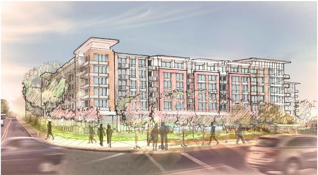
5 Landscape Plan Architectural Rendering 5
6 CITY OF ROCKVILLE MAYOR AND COUNCIL The City of Rockville Council approved an annexation plan for the subject petition on September 28, 2015 (see Attachment 1 for annexation plan). An annexation plan is required by the Maryland Local Government Article. A public hearing is scheduled for November 16, 2015 with the Mayor and Council. The City s Planning staff supports the MXTD designation on the Property since it is generally consistent with the County and the City Master Plans and fulfills the purposes and requirements of the zone, although the City zone allows greater density than the County zone. In addition, the proposed development is generally compatible with the surrounding community, the proposed annexation and its related development is in a location anticipated for growth by the MGE (Municipal Growth Element of the City of Rockville), and the impacts on services the City of Rockville will provide to the property owners can be covered by the tax revenue generated by the development. SECTOR PLAN The Site is located in the Metro West neighborhood within the 2006 Approved and Adopted Shady Grove Sector Plan area. The Sector Plan contains the following applicable recommendations for the Metro West neighborhood: Provide some commercial uses within all development to ensure an adequate mix of uses. Office and retail should be primarily located along MD 355 and Redland Road. Locate the Corridor Cities Transitway in the median of King Farm Boulevard Extended, elevated above street level to permit a cross-platform connection to Metro trains. If the Site were developed in the County, Staff would recommend to the Planning Board that the Applicant be expected to provide ancillary retail along MD 355 as envisioned by the Sector Plan. Residential development is clearly the priority, but the Sector Plan envisions mixed-use development in this area. At this point in time, Staff recognizes that there is concern over the demand for ground floor retail at this location. However, the Applicant has designed the building to accommodate future ground floor retail at which time such retail uses are supportable. The 6,300 square feet of floor space is located along the Rockville Pike frontage of the building, is accessible from Rockville Pike and has 15 heights suitable for retail uses if there is demand in the future. Staging The Sector Plan includes a staging element, and Stage 1 is limited to 2,540 residential dwelling units. Since adoption of the Sector Plan, 2,366 residential units have been approved leaving 174 residential units available in Stage 1. If the site were developed under the County s jurisdiction, absent an amendment to the Sector Plan, a maximum of 174 units could be approved at this time. The staging in the Shady Grove Sector Plan would preclude the full construction of the density in this annexation proposal until the triggers for Stage 2 have been met. 6
7 Environment The Sector Plan notes that excessive noise is a significant issue within the Plan area. It supports noisecompatible site design along Shady Grove Road, MD 355, Metro and CSX rail lines, the Solid Waste Transfer Station, and Roberts Oxygen (p.109). The Plan acknowledges the importance of the Solid Waste Transfer Station and the need to maintain its current location due to its use of the rail system for exporting solid waste. Its impacts on existing and proposed residential communities should be mitigated (p.55). The Plan further recommends to work with the Solid Waste Transfer Station to control odors by eliminating or relocating its yard waste processing area or through other innovative measures (p.109). Specifically, the Plan states that odors emanating from the Solid Waste Transfer Station are an additional air quality concern in the Shady Grove Sector Plan area (p.109). Future residential development adjacent to the Solid Waste facility could lead to complaints from future residents to either move or reduce functioning aspects of the existing facility. Streetscape The Sector Plan s streetscape plan recommends a new linear park along the Metro Access Road. The Plan recommends to create an extensively landscaped boulevard that leads to the Metro station. It should reflect the regreening of Shady Grove theme by establishing a garden character in the medians. Seating areas and other amenities should be provided within median areas that are over 50 feet wide to create outdoor places (p.89). The Plan also notes that all development shall participate in construction or funding adjacent roadway improvements along their frontage. Provision of new local streets within Metro Neighborhoods are primarily the responsibility of new development (p.81). The future redevelopment of the Property should provide similar streetscape improvements. PUBLIC SCHOOLS The property is within the Gaithersburg Cluster. According to the County s current FY 2016 Subdivision Staging Policy school test, the Elementary and Middle School levels are inadequate in the Gaithersburg Cluster. If the site were developed under the County s Adequate Public Facilities Ordinance, a school facilities payment would be required at both levels at the time of building permit. ANNOTATED CODE OF MARYLAND Section of the Maryland Code s Local Government Article, titled Power to enlarge municipal boundaries by annexation, states: (a) Subject to subsections (b) and (c) of this section, the legislative body of a municipality may enlarge its boundaries by annexation as provided in this subtitle. Land to which power applies (b) The power of annexation applies only to land that: (1) is contiguous and adjoining to the existing boundaries of the municipality; and (2) does not create an unincorporated area that is bounded on all sides by: 7
 or (ii) of this item. Annexation of land in another municipality prohibited (c) A municipality may not annex land that is in another municipality.")
8 (i) real property presently in the boundaries of the municipality; (ii) real property proposed to be in the boundaries of the municipality as a result of the proposed annexation; or (iii) any combination of real property described in item (i) or (ii) of this item. Annexation of land in another municipality prohibited (c) A municipality may not annex land that is in another municipality. This annexation petition meets these requirements since (1) the Site is contiguous and adjoining the City s boundary; (2) its annexation will not create an unincorporated area bounded on all sides by real property within the boundaries of the municipality; and (3) the Site is not part of another municipality. Further, the Site is within the City s Maximum Expansion Limits (MEL). The MEL boundary is indicated by red hash marks on the following map. CarMax Location (Outlined in Red) Section of the Maryland Code s Local Government Article, titled Public notice and hearing on resolution, states in relevant part: (a) After an annexation resolution is introduced, the chief executive and administrative officer of the municipality shall publish notice in accordance with the requirements of this section that: 8
9 (1) briefly and accurately describes the proposed annexation and the applicable conditions and circumstances; and (2) specifies the date, time, and place that the legislative body sets for the public hearing on the proposed annexation. Notice to county and planning agencies (c) Immediately after the first publication of the public notice, the municipality shall provide a copy of the public notice to: (1) the governing body of the county in which the municipality is located; and (2) any regional or State planning agency with jurisdiction in the county. The letter from the City of Rockville, dated July 24, 2015, serves as official notification of the proposed annexation, as required by Section It states that the Mayor and City Council will hold a public hearing regarding the proposed annexation on a date to be announced. The City Council approved the annexation plan on September 28, 2015, and scheduled the public hearing for November 16, Different Land Use or Density Maryland s Local Government Article places some restrictions on changes in land use and zoning when a property is annexed into a municipality. Section 4-416(b) states that: Without the express approval of the county commissioners or county council of the county in which the municipality is located, for 5 years after an annexation by a municipality, the municipality may not allow development of the annexed land for land uses substantially different than the authorized use, or at a substantially higher density, not exceeding 50%, than could be granted for the proposed development, in accordance with the zoning classification of the county applicable at the time of the annexation. County Approval of Zoning Classification Section 4-416(c) further states that: if the county expressly approves, the municipality may place the annexed land in a zoning classification that allows a land use or density different from the land use or density specified in the zoning classification of the county or agency with planning and zoning jurisdiction over the land prior to its annexation applicable at the time of the annexation. The land uses permitted in the City s Mixed Use Transit District (MXTD) are similar to the County s CRT Zone. Both zones are intended for transit station areas where intense mixed-use development is recommended, with an emphasis/priority on residential development. The MXTD permits buildings up to 120 feet in height, while the building height established by the applicable County zone and Sector Plan is 100 feet. Without the express approval of the County Council, the proposed development may be delayed for five years under Section 4-416(b) of the Maryland Local Government Article. The County s CRT 1.5, C 0.5, R 1.25, H100 Zone allows a maximum total density of 1.5 FAR (311,738 square feet or 1.77 FAR with MPDU bonus density), and up to 1.25 FAR (267,831 square feet or 1.52 FAR with MPDU bonus density) for a 100 percent residential development. The annexation petition will permit residential development at 458,225 square feet or 2.61 FAR. The overall development is therefore substantially higher than the 9
10 maximum density allowed in the County Zone. However, considering the MPDU bonus density, the proposed density will be under the additional 50 percent permitted under Section 4-416(b) of the Maryland Local Government Article. ENVIRONMENT Shady Grove Sector Plan-Metro West Density Recommendation The environmental objectives in the Shady Grove Sector Plan include creating a green network of urban parks and open spaces; retaining existing green infrastructure; mitigating negative environmental impacts, such as noise; and developing strategies to reduce air pollution and odors. There are no streams, wetlands or forest on the subject site. TRANSPORTATION The Site fronts onto Frederick Road (MD-355) and the Metro Access Road/King Farm Boulevard Extended. This segment of Frederick Road is classified as a major highway with a 120-foot right-of-way. The Sector Plan envisions this segment of MD 355 between Indianola Drive and the Solid Waste Transfer Station to be transformed into an urban boulevard. This entails a median, requiring slower speeds, enhanced with streetscape and emphasizing pedestrian safety and access (p.79). A series of new commercial business streets are recommended in the Metro West neighborhood. King Farm Boulevard Extended/Metro Access Road (B-4) is identified as Street A and recommended for a 120-foot right-of-way. The recommended right-of-way for King Farm Boulevard extended/metro Access Road (B-4) is 120 feet, and should be implemented via the annexation petition. Street D is also 10
11 recommended on the Property as part of the proposed public street network (illustrated below), and is recommended as a 60-foot right-of-way. The proposal shows a pedestrian and vehicular entrance to the proposed development terminating at the proposed parking garage. If the Site were developed in the County, Staff would recommend to the Planning Board that the Applicant be expected to provide the master-planned connection as envisioned by the Sector Plan. Corridor Cities Transitway Sector Plan Street Network The right-of-way for the Corridor Cities Transitway (CCT) is along King Farm Boulevard Extended/Metro Access Road. The CCT is proposed as either a light-rail transit or bus rapid transit system that will connect Shady Grove to Clarksburg. The annexation petition must reserve the recommended right-ofway along King Farm Boulevard Extended/Metro Access Road. Bike Network Two Class I Shared Use Paths (SP-64) and (SP-66) are recommended for the entire length of Frederick Road in the Plan area, and the Metro Access Road, respectively. 11
12 CONCLUSION The petition proposes a use that is in substantial conformance with uses authorized in both the CRT Zone and the Approved and Adopted Shady Grove Sector Plan. Further, while the achievable density by the proposed zone is substantially higher than the current zone and Sector Plan s recommendation, the proposed development is within the 50% additional density permitted under Section of the Maryland Local Government Article. Staff believes the proposed development/annexation request is in substantial conformance with the Sector Plan and the established development pattern of the surrounding area; Staff, therefore, recommends that the Montgomery County Council grant the zoning request. Attachment 1. City of Rockville Annexation Plan 12
, the Annexation Plan shall include a description of the land use pattern proposed for the area to be annexed,")
13 Annexation Plan Annexation Case No: ANX This Annexation Plan is prepared as a result of an applicant initiated request to annex land into the City of Rockville. Pursuant to Local Government Code of the Annotated Code of Maryland (Exhibit 9), the Annexation Plan shall include a description of the land use pattern proposed for the area to be annexed, demonstrate the available land for public facilities, and describe the schedule for extending the public services and the anticipated means of financing the extension of services. The following description fulfills the requirement. The area proposed for annexation is within the City s Maximum Expansion Limits, as established in the City s Master Plan and the Municipal Growth Element, adopted in December General Information and Description Petitioners: Frederick Road, LLC c/o Silverwood Investments 1925 Isaac Newton Square East, Suite 110 Reston, VA ATTACHMENT 1 Location: The parcel of land proposed for annexation is located at the southeast corner of the intersection of Shady Grove Metro Access Road and Frederick Road. Also described as Frederick Road or Parcel N, Derwood, recorded in Plat Book 179, Plat Exhibit A shows the parcel to be annexed. The area proposed for annexation is approximately acres or 175,634 square feet. The metes and bounds description of the proposed annexation is included as Attachment A. Background Pursuant to the Local Government Article, Division II, Title 4, Subtitle 4 Annexation, of the Annotated Code of Maryland, an annexation plan shall be adopted by the legislative body for the area to be annexed. The annexation plan shall demonstrate that the proposed annexation is consistent with the Municipal Growth element of the Comprehensive Plan of the municipality. 1
14 Land Use Patterns of area proposed to be annexed The area of annexation is approximately acres (or 175,634 square feet). Existing Conditions: The project site is a developed site with an existing building that houses a car dealership, constructed prior to the current zoning. The land is adjacent to properties with the County's CRT zoning designation. The Metro Station parking lot abuts this property at the rear of the site. A day care facility and retail/auto repair facility also abuts this property to south. To the west across MD 355 is the King Farm development and a number of multi-family buildings. The proposed residential use is consistent with the existing residential development across MD 355 and the County's Shady Grove Sector Plan's vision of a mixed use transit oriented development surrounding the metro station. The sector plan specifically anticipates high density residential development on this property. The property is governed by the County's Shady Grove Sector Plan, which plans for a mix of uses with a residential density of dwelling units per acre. The property on the opposite side of Shady Grove Metro Access Road was annexed into the City in 2012 and a multi-family residential development similar to what has been proposed for this site has been constructed. This recently annexed property located within the City is zoned MXTD-Mixed Use Transit District, which is the same district the applicant has requested. Current Zoning: The zoning is CRT1.5, C 0.25, R1.25, H100 (Commercial Residential Town) within Montgomery County. The County zoning allows for a mixture of uses and regulates these uses based on a prescribed Floor-to-Area (FAR) ratio. In addition, the maximum height permitted in this district is 100 feet. Bonus density is permitted based on the provision of affordable dwelling units. Proposed Zoning: The applicant has requested a zoning of MXTD-Mixed Use Transit District upon annexation, which allows for a similar use structure as the current County zoning district of the Commercial Residential Town (CRT). For that reason, the proposed MXTD zoning is generally consistent with the County Master Plan and the Shady Grove Sector Plan, as adopted by the Maryland National Park and Planning Commission. The MXTD zoning designation provides for a similar transit oriented mixture of uses. However, the Shady Grove plan anticipates ground floor retail in this area, which is not proposed by the applicant but is permitted in the MXTD zoning district. The MXTD zoning does not have a FAR requirement that would cap density on the site in the same manner as the County s CRT designation. While the County Plan anticipates a density of dwelling units per acre, the County s recently adopted zoning ordinance would allow for approximately 70 units per acre with additional commercial square footage. In addition, the MXTD zoning allows for a building height of up to 120 feet, with the potential of 150 feet if approved. The applicant is proposing a building height of 85 feet. 2
15 A comparison of the County CRT district and the City s MXTD district is provided in the following chart. This chart also details the specific statistics of the applicant s proposed development. Proposed Frederick Road LLC Development MXTD Maximum CRT Maximum (Per County Staff) Height 85 (6 or 7 stories) Residential FAR 2.61 No FAR Maximum (with 22% Density Bonus for Providing 15% MPDU) Commercial FAR N/A No FAR Maximum 0.25 in addition to Residential FAR Open Space 21% 15% 10% Residential Square Footage 458,225 square feet (7 stories) Based on 65,000 per floor (per applicant estimate of 7 stories and 458,225 sq.ft.), the applicant could construct 3 additional stories and be within the 120 height requirement: 267,831 square feet maximum Commercial Square Footage Total Achievable Under Zoning No Commercial Use Proposed Total square footage permitted 653,225 Commercial Use Permitted 653,225 residential square feet with a 10 story building 43,907 square feet maximum (Required) 311,738 residential and commercial square feet in an 8 story building Compliance with Municipal Growth Element of City of Rockville Plan: The subject property is consistent with the Municipal Growth Element of the City of Rockville Plan and is within the boundaries of the City s urban growth boundary. The property in question is next to property that was annexed into the City in The MGE anticipates that the areas available for growth in Rockville are infill locations in the I-270 and MD 355 corridors. These areas are developed with single use commercial uses that will be redeveloped into mixed-use properties where supported by zoning and market forces. The MGE anticipates new residential development to be multi-family. The 2010 MGE expanded the City s Maximum Expansion Limits (MELs) in the Shady Grove metro station area in order to achieve positive fiscal benefits and allow for control over development in areas that already affect the City (MGE p.68). 3
16 Adequacy of Public Facilities Water and Sewer: The Washington Suburban Sanitary Commission (WSSC) currently provides public water and sewer services to the property within the annexation area. No changes in service will occur as a result of the annexation, although the specifics of the sewer and water service will be evaluated as part of a site plan application. WSSC has the capacity to provide service to the property in question. Roads: The existing public roads are adequate to serve the property s current use within the annexation area. The site is currently improved and occupied by an auto dealership building. Additional development is proposed for the site and traffic impact will be analyzed as part of any proposed future Site Plan application. Transit: The site is immediately adjacent to the Shady Grove Metro Station. Bus service is also available through Ride On and WMATA. In addition to these current transit options, the 355 corridor is on the route of the planned Corridor Cities Transitway (CCT) bus rapid transit (BRT) project. Police Services: Police protection will primarily be provided by the Rockville Police Department in conjunction with the Montgomery County Police Department. County Police District 1 serves Rockville, though the resources of the entire County Department are available if needed. Fire, EMS and Rescue Services: No significant impacts on emergency services and public schools are anticipated as a result of this annexation since there are no proposed changes to existing uses. The Montgomery County Fire and Emergency Services (MCFRS) provides fire and disaster protection. Rockville does not provide this service as a part of its municipal government. There are two fire stations in Rockville. Station 3, at 380 Hungerford Drive, serves this area, although other stations are available to supplement service (Station 28 on Muncaster Mill Rd. in Rockville, Station 8 on Russell Avenue in Gaithersburg and Station 32 at 9615 Darnestown Road). The property meets the APF standard of response by two stations within ten minutes. School Services: No significant impacts on Montgomery County public schools system are anticipated as a result of this annexation. Concurrent with the Level 2 site plan review, required for any proposed residential development of the site, an analysis of the school capacity will be made and any impacts will be identified. The City estimates a maximum total of 62 students, distributed through the three school levels will be generated from a development on this property. Even at this level, the Gaithersburg cluster (Washington Grove ES. Forest Oak MS, Gaithersburg HS) can adequately support the additional increase in students at each school. 4
17 Parks and Recreation/Public Libraries: Parks and recreation facility expansions are not proposed for this annexation. Currently, the closest park facilities are located in the King Farm development and include the Farmstead, Stepanek Park and King Farm Park. The County sector plan proposes a town square near the metro to be developed as part of a public/private redevelopment of the WMATA property. The current and proposed zones have open space requirements for public use space that must be met with redevelopment. The County CRT designation requires 10% of the site be maintained as open space, while the MXTD district requires 15%. The concept currently proposed by the applicant provides for 21% open space. The closet library to the project is the Rockville Memorial Library. Stormwater Management: If annexed, all properties shall be required to pay an annual Stormwater Management Utility Fee in accordance with Section of the City Code. The City Stormwater Management Utility Fee will replace the Water Quality Protection Charge, an annual fee assessed by the Montgomery County Department of Environmental Protection. Additionally, a review of stormwater management will be conducted as part of the site plan process required for future development or redevelopment of the site. Impact on sensitive environmental areas: Since the site is currently developed with a car dealership, and the site mostly paved, there are no impacts to environmental resources on or immediately adjacent to the site. Cost to the City on having to provide such services: The 2012 Development Fiscal Impact Analysis conducted for the City concluded that a multiple family dwelling unit valued at approximately $190,000 (based on 2012/2013FY dollars) would result in a break even fiscal impact to the City. While there will be fiscal impacts to the City due to the proposed development, it is expected that the additional tax revenue generated on an annual basis would outweigh those costs. By comparing similarly situated developments in the City, the City s fiscal impact model concludes that the proposed development would result in a net benefit of between $2,505 and $14,633 per year over the next 20 years. Conclusion In summary, the proposed area to be annexed is generally consistent with the County and the City Master Plans and fulfills the purposes and requirements of the zone, although the City zone allows greater density than the County zone. In addition, the proposed development is generally compatible with the surrounding community, the proposed annexation and its related development is in a location anticipated for growth by the MGE, and the impacts on services the City of Rockville will provide to the property owners can be covered by the tax revenue generated by the development. 5
18 Attachment A 6
19 7
MONTGOMERY COUNTY PLANNING DEPARTMENT THE MARYLAND-NATIONAL CAPITAL PARK AND PLANNING COMMISSION
 MONTGOMERY COUNTY PLANNING DEPARTMENT THE MARYLAND-NATIONAL CAPITAL PARK AND PLANNING COMMISSION MCPB Item No. Date: 12/4/14 Preliminary Plan No. 120140200, Northwood Knolls Description Patrick Butler,
JUSTIFICATION STATEMENT FOR PRELIMINARY PLAN NO Preliminary Plan Justification for Chevy Chase Lake
 I. INTRODUCTION JUSTIFICATION STATEMENT FOR PRELIMINARY PLAN NO. 120150130 Preliminary Plan Justification for Chevy Chase Lake Applicant, CC Associates LLC (the Applicant ), by its attorneys, Linowes and
Staff Report: Date: Applicant: Property Identification: Acreage of Request: Current Zoning of Requested Area: Requested Action: Attached:
 Staff Report: Completed by Jeff Palmer Director of Planning & Zoning Date: November 7, 2018, Updated November 20, 2018 Applicant: Greg Smith, Oberer Land Developer agent for Ronald Montgomery ET AL Property
MEMORANDUM. City Council. David J. Deutsch City Manager. Resolution R TLBT, LLC Annapolis Road Annexation Plan. DATE: September 3, 2015
 MEMORANDUM TO: FROM: RE: City Council David J. Deutsch City Manager Resolution R-66-15 TLBT, LLC 13401 Annapolis Road Annexation Plan DATE: September 3, 2015 In accordance with the Annotated Code of Maryland,
MONTGOMERY COUNTY PLANNING DEPARTMENT THE MARYLAND-NATIONAL CAPITAL PARK AND PLANNING COMMISSION
 MONTGOMERY COUNTY PLANNING DEPARTMENT THE MARYLAND-NATIONAL CAPITAL PARK AND PLANNING COMMISSION MCPB Item No.: Date: 06-21-12 The Plantations, Preliminary Plan -120090240 Benjamin Berbert, Senior Planner,
MONTGOMERY COUNTY PLANNING DEPARTMENT THE MARYLAND-NATIONAL CAPITAL PARK AND PLANNING COMMISSION
 MONTGOMERY COUNTY PLANNING DEPARTMENT THE MARYLAND-NATIONAL CAPITAL PARK AND PLANNING COMMISSION Colesville Senior Living Facility, Limited Preliminary Plan Amendment, 12016011A MCPB Consent Item Date:
MPC STAFF REPORT REZONING MAP AMENDMENT ALDERMANIC DISTRICT 1 COUNTY COMMISSION DISTRICT 5 April 3, 2013 MPC FILE NUMBER.
 MPC STAFF REPORT REZONING MAP AMENDMENT ALDERMANIC DISTRICT 1 COUNTY COMMISSION DISTRICT 5 April 3, 2013 MPC FILE NUMBER. 13-000929-ZA REZONING SUMMARY Report Status Initial Report Petitioner/Property
MONTGOMERY COUNTY PLANNING DEPARTMENT THE MARYLAND-NATIONAL CAPITAL PARK AND PLANNING COMMISSION
 MONTGOMERY COUNTY PLANNING DEPARTMENT THE MARYLAND-NATIONAL CAPITAL PARK AND PLANNING COMMISSION MCPB Item No. Date: 9/22/11 Site Plan Amendment 82008011A, North Bethesda Center Parcels F, I, & J Joshua
13 Sectional Map Amendment
 13 Sectional Map Amendment Introduction This chapter reviews land use and zoning policies and practices in Prince George s County and presents the proposed zoning in the sectional map amendment (SMA) to
Residential Capacity Estimate
 Residential Capacity Estimate Montgomery County Department of Park & Planning Research & Technology Center January 2005 Current plans allow 75,000 more housing units. by Matthew Greene, Research Planner
MONTGOMERY COUNTY PLANNING DEPARTMENT THE MARYLAND-NATIONAL CAPITAL PARK AND PLANNING COMMISSION
 MONTGOMERY COUNTY PLANNING DEPARTMENT THE MARYLAND-NATIONAL CAPITAL PARK AND PLANNING COMMISSION MCPB Item No. 8 Date: 03-07-13 Sonoma, Preliminary Plan, 120130040 Melissa Williams, Senior Planner, Melissa.williams@montgomeryplanning.org,
RECOMMENDATION: Approval subject to the following conditions:
 RECOMMENDATION: Approval subject to the following conditions: 1) Approval under this preliminary plan is limited to 2 lots for 2 dwelling units 2) The record plat must note that the preliminary plan is
Metropolitan Planning Commission. DATE: April 5, 2016
 TO: FROM: Metropolitan Planning Commission MPC Staff DATE: April 5, 2016 SUBJECT: Petition of Nine Line Inc. Robert McCorkle, Agent PIN: 2-1034-01-002 380.5 Acres Aldermanic District: 5 (Shabazz) County
Staff Report: Date: Applicant: Property Identification: Acreage of Request: Current Zoning of Requested Area: Requested Action: Attached:
 Staff Report: Completed by Jeff Palmer Director of Planning & Zoning Date: November 7, 2018 Applicant: Greg Smith, Oberer Land Developer agent for Ronald Montgomery ET AL Property Identification: Frontage
The Planning Commission. DATE: July 19, 2016
 TO: FROM: The Planning Commission MPC Staff DATE: SUBJECT: Petition of Chatham Savannah Authority for the Homeless Cindy Kelley, Agent Saffold Properties L.P. (John Saffold), Owner Aldermanic District:
MONTGOMERY COUNTY PLANNING DEPARTMENT THE MARYLAND-NATIONAL CAPITAL PARK AND PLANNING COMMISSION
 MONTGOMERY COUNTY PLANNING DEPARTMENT THE MARYLAND-NATIONAL CAPITAL PARK AND PLANNING COMMISSION MCPB Item No. Date: 12/6/12 Limited Site Plan Amendment, 82000018D, DANAC Stiles Property, Lot 6 of Block
PLANNING COMMISSION STAFF REPORT
 PLANNING COMMISSION STAFF REPORT West Capitol Hill Zoning Map Amendment Petition No. PLNPCM2011-00665 Located approximately at 548 W 300 North Street, 543 W 400 North Street, and 375 N 500 West Street
O-I (Office-Institutional) and AG-1(Agricultural)
 and AG-1(Agricultural)") PROPERTY INFORMATION ADDRESS 3503 and 3505 Bethany Bend DISTRICT, LAND LOTS 2/1 973 and 974 OVERLAY DISTRICT State Route 9 PETITION NUMBERS EXISTING ZONING O-I (Office-Institutional) and AG-1(Agricultural)
PROPERTY INFORMATION ADDRESS 3503 and 3505 Bethany Bend DISTRICT, LAND LOTS 2/1 973 and 974 OVERLAY DISTRICT State Route 9 PETITION NUMBERS EXISTING ZONING O-I (Office-Institutional) and AG-1(Agricultural)
PLANNING COMMISSION STAFF REPORT
 PLANNING COMMISSION STAFF REPORT REZONING CASE: RZ-16-001 REPORT DATE: March 8, 2016 CASE NAME: Trailbreak Partners Rezoning PLANNING COMMISSION DATE: March 16, 2016 ADDRESSES OF REZONING PROPOSAL: 5501
STAFF REPORT. January 25, North York Community Council. Director, Community Planning, North District
 STAFF REPORT January 25, 2005 To: From: Subject: Purpose: North York Community Council Director, Community Planning, North District Refusal Report OPA & Rezoning Application 04 194214 NNY 33 OZ Applicant:
Prior Planning Board Worksessions
 Prior Planning Board Worksessions January 27: Focused on transportation analysis and staging recommendations in the Draft Plan. February 9: Reviewed the Executive Boulevard District and associated economic
WHEREAS, the staff of The Maryland-National Capital Park and Planning Commission recommended APPROVAL of the application with conditions; and
 R E S O L U T I O N WHEREAS, Redeemed Christian Church of God is the owner of a 2.83-acre parcel of land known as Lot 9, Lot 19, P/O Lot 1 and P/O Lot 18, Block B, Plat Book A, Plat 5, said property being
Approval of Takoma Amended Joint Development Agreement and Compact Public Hearing
 Planning, Program Development and Real Estate Committee Item IV - B March 13, 2014 Approval of Takoma Amended Joint Development Agreement and Compact Public Hearing Washington Metropolitan Area Transit
3.1. OBJECTIVES FOR RESIDENTIAL LAND USE DESIGNATIONS GENERAL OBJECTIVES FOR ALL RESIDENTIAL DESIGNATIONS
 3. RESIDENTIAL LAND USE DESIGNATIONS INTRODUCTION The Residential land use designations provide for housing and other land uses that are integral to, and supportive of, a residential environment. Housing
PALM BEACH COUNTY PLANNING, ZONING AND BUILDING DEPARTMENT ZONING DIVISION
 PALM BEACH COUNTY PLANNING, ZONING AND BUILDING DEPARTMENT ZONING DIVISION Application No.: CA-2012-00688 Control No.: 2011-00552 Applicant: Garry Bernardo Owners: Garry Bernardo Agent: Frogner Consulting,
Mount Airy Planning Commission March 26, Staff Report
 Mount Airy Planning Commission March 26, 2018 Staff Report Special Exception Request Mixed Use Development in CC District Recommendation to Board of Appeals CASE MA-A-18-01 Applicant: Location: Zoning:
Approval of Takoma Amended Joint Development Agreement
 Planning, Program Development and Real Estate Committee Item IV- A October 10, 2013 Approval of Takoma Amended Joint Development Agreement Washington Metropolitan Area Transit Authority Board Action/Information
Planning Department Oconee County, Georgia
 Planning Department Oconee County, Georgia STAFF REPORT REZONE CASE #: 6985 DATE: October 31, 2016 STAFF REPORT BY: Andrew C. Stern, Planner APPLICANT NAME: Williams & Associates, Land Planners PC PROPERTY
Implementation. Approved Master Plan and SMA for Henson Creek-South Potomac 103
 Implementation Approved Master Plan and SMA for Henson Creek-South Potomac 103 104 Approved Master Plan and SMA for Henson Creek-South Potomac Sectional Map Amendment The land use recommendations in the
Plan Area and Current Facilities
 Plan Area and Current Facilities The Plan Area is bounded by South Delaware Street to the east and Concar Drive to the south (Figure 2.01). Parallel to Concar Drive on the south, SR 92 rises above grade
MONTGOMERY COUNTY PLANNING DEPARTMENT THE MARYLAND-NATIONAL CAPITAL PARK AND PLANNING COMMISSION
 MONTGOMERY COUNTY PLANNING DEPARTMENT THE MARYLAND-NATIONAL CAPITAL PARK AND PLANNING COMMISSION MCPB Item No. 3 Date: 01-31-13 Preliminary Plan 120090300, Boyds Highlands Calvin Nelson, Jr. Planner Coordinator,
Master Plan Review SILVER SPRING CBD. Approved and Adopted February Updated January 2013
 Master Plan Review SILVER SPRING CBD Approved and Adopted February 2000 BACKGROUND ZONING CODE REWRITE In 2007, the Montgomery County Council directed the Planning Department to undertake a comprehensive
GROSVENOR-STRATHMORE METRO STATION MANDATORY REFERRAL APPLICATION NORTH BETHESDA, MD
 GROSVENOR-STRATHMORE METRO STATION MANDATORY REFERRAL APPLICATION NORTH BETHESDA, MD Submission by: Fivesquares JDA at Grosvenor Metro, LLC On behalf of Washington Metropolitan Area Transit Authority 1
RC ; Reclassification The Garrison at Stafford Proffer Amendment (formerly Stafford Village Center)
") Board of Supervisors Robert Bob Thomas, Jr., Chairman Laura A. Sellers, Vice Chairman Meg Bohmke Jack R. Cavalier Wendy E. Maurer Paul V. Milde, III Gary F. Snellings Anthony J. Romanello, ICMA CM County
Board of Supervisors Robert Bob Thomas, Jr., Chairman Laura A. Sellers, Vice Chairman Meg Bohmke Jack R. Cavalier Wendy E. Maurer Paul V. Milde, III Gary F. Snellings Anthony J. Romanello, ICMA CM County
PLANNING COMMISSION PUBLIC HEARING STAFF REPORT ZRTD FAIRFAX MARBLE & GRANITE
 Date of Hearing: PLANNING COMMISSION PUBLIC HEARING STAFF REPORT SUBJECT: ELECTION DISTRICT: ZRTD-2016-0009 FAIRFAX MARBLE & GRANITE Broad Run CRITICAL ACTION DATE: September 27, 2017 STAFF CONTACTS: APPLICANT:
9. REZONING NO Vicinity of the northwest corner of 143 rd Street and Metcalf Avenue
 9. REZONING NO. 2002-15 Vicinity of the northwest corner of 143 rd Street and Metcalf Avenue 1. APPLICANT: Andrew Schlagel is the applicant for this request. 2. REQUESTED ACTION: The applicant is requesting
Kitsap County Department of Community Development
 Kitsap County Department of Community Development Staff Report and Recommendation Annual Comprehensive Plan Amendment Process for 2018 George s Corner LAMIRD Boundary Adjustment Report Date 7/16/2018 Hearing
PLANNING COMMISSION REPORT Regular Agenda -Public Hearing Item
 PDP-13-00518 Item No. 3B- 1 PLANNING COMMISSION REPORT Regular Agenda -Public Hearing Item PC Staff Report 2/24/14 ITEM NO. 3B PRELIMINARY DEVELOPMENT PLAN FOR HERE @ KANSAS; 1101 INDIANA ST (SLD) PDP-13-00518:
Hamilton County Regional Planning Commission
 Hamilton County Regional Planning Commission March 1, 2012 Colerain Township Staff Report Zone Map Amendment: Case No.: ZA2012-01 Joseph Toyota Prepared By: Amy Bancroft, Land Use Planner ACTION REQUESTED:
Marion County Board of County Commissioners
 Marion County Board of County Commissioners Date: 12/29/2015 P&Z: 12/28/2015 BCC: 1/12/2016 Item Number 160113Z Type of Application Rezoning Request From: A-1 (General Agriculture) To: PUD (Planned Unit
Prince George s County Zoning Ordinance and Subdivision Regulations Rewrite March 13, 2017
 Prince George s County Zoning Ordinance and Subdivision Regulations Rewrite March 13, 2017 The Maryland National Capital Park & Planning Commission 1 Worksessions Schedule Topic Date Zone Structure January
PLANNING COMMISSION REPORT Regular Agenda - Public Hearing Item
 Z-11-25-09; Z-11-26-09; Z-11-28-09 Item No. 2-1 PC Staff Report 3/28/11 PLANNING COMMISSION REPORT Regular Agenda - Public Hearing Item ITEM NO. 2A RM32 TO MU;.19 ACRES; 1340 TENNESSEE ST (MJL) Z-1-1-11:
Cover Letter with Narrative Statement
 Cover Letter with Narrative Statement March 31, 2017 rev July 27, 2017 RE: Rushton Pointe Residential Planned Unit Development Application for Public Hearing for RPUD Rezone PL2015 000 0306 Mr. Eric Johnson,
Staff Report. Planning Commission Public Hearing: October 17, 2007 Staff Recommendation: Denial
 COUNTY OF PRINCE WILLIAM 5 County Complex Court, Prince William, Virginia 22192-9201 PLANNING (703) 792-6830 Metro 631-1703, Ext. 6830 FAX (703) 792-4401 OFFICE Internet www.pwcgov.org Stephen K. Griffin,
City of Valdosta Land Development Regulations
 Chapter 206 Section 206-1 Base Zoning Districts Standards for Uses, Structures, and Property Development (B) (C) Principal Uses and Structures. Principal uses and structures permitted in each base zoning
DISTRICT COUNCIL FOR PRINCE GEORGE'S COUNTY, MARYLAND OFFICE OF THE ZONING HEARING EXAMINER ZONING MAP AMENDMENT A DECISION
 DISTRICT COUNCIL FOR PRINCE GEORGE'S COUNTY, MARYLAND OFFICE OF THE ZONING HEARING EXAMINER ZONING MAP AMENDMENT A-10029 DECISION Application: R-R to C-M Zone Applicant: Santos, LLC Opposition: Richard
MEMORANDUM. DATE: November 9, 2016 PC Agenda Item 3.B. Planning Commission Chair Thompson and Commissioners
 MEMORANDUM DATE: November 9, 2016 PC Agenda Item 3.B TO: FROM: SUBJECT: Planning Commission Chair Thompson and Commissioners Matthew Bachler, Senior Planner Planning Case #16-028 Public Hearing Required
MONTGOMERY COUNTY PLANNING BOARD
 MONTGOMERY COUNTYPLANNING BOARD T H E MARYLAND-NATIONAL CAPITAL PARK A N D P L A N N I N G C O M M I S S I O N MCPB NO. 10-100 Preliminary Plan No. 120100210 Date of Hearing: July 1, 2010 MONTGOMERY COUNTY
MIDWAY CITY Municipal Code
 MIDWAY CITY Municipal Code TITLE 9 ANNEXATION CHAPTER 9.01 PURPOSE CHAPTER 9.02 GENERAL REQUIREMENTS CHAPTER 9.03 PROPERTY OWNER INITIATION OF ANNEXATION CHAPTER 9.04 PROCEDURES FOR CONSIDERATION OF PETITION
STAFF REPORT. Permit Number: Laurier Enterprises, Inc. Kitsap County Board of Commissioners; Kitsap County Planning Commission
 STAFF REPORT Permit Number: 15 00740 Laurier Enterprises, Inc. DATE: December 18, 2015 TO: FROM: Kitsap County Board of Commissioners; Kitsap County Planning Commission Katrina Knutson, AICP, Senior Planner,
CITY OF NAPLES STAFF REPORT
 Meeting of 05/13/15 Conditional Use Petition 15-CU3 CITY OF NAPLES STAFF REPORT To: Planning Advisory Board From: Planning Department Subject: Conditional Use Petition 15-CU3 Petitioner: Hazelden Betty
Ashcroft Homes Trim Road Development Planning Rationale
 18 Antares Drive Ottawa, ON K2E 1A9 Ashcroft Homes Trim Road Development Planning Rationale Proposed Site Plan & Zoning Amendment Applications File No: D02-02-17-0129 & D07-12-17-0175 August 2018 Planning
SUBJECT: Application for Planned Unit Development and Rezoning 1725 Winnetka Road
 TO: FROM: CHAIRMAN BILL VASELOPULOS AND MEMBERS OF THE PLAN & ZONING COMMISSION STEVE GUTIERREZ DIRECTOR OF COMMUNITY DEVELOPMENT MEETING DATE: September 5, 2017 SUBJECT: Application for Planned Unit Development
CITY OF WEST PALM BEACH PLANNING BOARD Meeting Date: July 17, 2018 Planning Board Case No. 1670I
 CITY OF WEST PALM BEACH PLANNING BOARD Meeting Date: July 17, 2018 Planning Board Case No. 1670I Palms Gateway Commercial Planned Development (CPD) Southeast Corner of Belvedere Road and Australian Avenue
Financial Impact Statement There are no immediate financial impacts associated with the adoption of this report.
 STAFF REPORT Planning and Development Department Subject: Application by RYC Property to rezone a portion of lands on John Murray Dr. and Megan Lynn Dr. from R2 to R3 and to enter into a Development Agreement
MONTGOMERY COUNTY PLANNING DEPARTMENT THE MARYLAND-NATIONAL CAPITAL PARK AND PLANNING COMMISSION
 MONTGOMERY COUNTY PLANNING DEPARTMENT THE MARYLAND-NATIONAL CAPITAL PARK AND PLANNING COMMISSION MCPB Consent Item Date: 11-2-17 Washington Adventist Hospital, Site Plan Amendment No. 82008021F Rhoda Hersson-Ringskog,
Town of Waxhaw Board of Commissioners. Waxhaw Police Department Community Meeting Room Tuesday January 12, 2016
 Town of Waxhaw Board of Commissioners Waxhaw Police Department Community Meeting Room Tuesday January 12, 2016 Petition RZ-003994-2015 A request by the Town of Waxhaw Planning & Community Development Department,
MONTGOMERY COUNTY PLANNING DEPARTMENT THE MARYLAND-NATIONAL CAPITAL PARK AND PLANNING COMMISSION
 MONTGOMERY COUNTY PLANNING DEPARTMENT THE MARYLAND-NATIONAL CAPITAL PARK AND PLANNING COMMISSION MCPB Item No.: Date: 07-28-16 Lake Normandy Estates: Pre-Preliminary Plan No. 720160020 Ryan Sigworth AICP,
PGCPB No File No R E S O L U T I O N
 R E S O L U T I O N WHEREAS, Jemal s Calvert II, LLC is the owner of a 1.69-acre parcel of land known as Greenhorne & O Mara s Addition to Riverdale Gardens, Parcel 1, said property being in the 19th Election
MONTGOMERY COUNTY PLANNING DEPARTMENT THE MARYLAND NATIONAL CAPITAL PARK AND PLANNING COMMISSION
 MONTGOMERY COUNTY PLANNING DEPARTMENT THE MARYLAND NATIONAL CAPITAL PARK AND PLANNING COMMISSION Bethesda Downtown Sector Plan, Work Session #4 MCPB Item No. Date: 10-29-15 Leslye Howerton, Planner Coordinator,
MEMORANDUM. Action. Staff recommends approval of the attached resolution.
 AGENDA ITEM #5 February 11,2014 Action MEMORANDUM February 7, 2014 TO: County Council, ~ FROM: SUBJECT: Marlene Michaelso~enior Legislative Analyst Action: Glenmont Sectional Map Amendment (G-959) Attached
Kitsap County Department of Community Development
 Kitsap County Department of Community Development Staff Report and Recommendation Annual Comprehensive Plan Amendment Process for 2018 Public Facility Designations and Park Classifications Update Report
Bowie Marketplace Residential Detailed Site Plan Statement of Justification January 13, 2017 Revised February 2, 1017
 Bowie Marketplace Residential Detailed Site Plan Statement of Justification January 13, 2017 Revised February 2, 1017 Submitted on behalf of: BE Bowie LLC 5410 Edson Lane, Suite 220 Rockville, MD 20852
ARTICLE I ZONE BASED REGULATIONS
 ARTICLE I ZONE BASED REGULATIONS RZC 21.08 RESIDENTIAL REGULATIONS 21.08.290 Cottage Housing Developments A. Purpose. The purpose of the cottage housing requirements is to: 1. Provide a housing type that
CREEKSIDE TOWNHOMES Chevy Chase, Maryland Site Plan No Preliminary Plan No
 +1 (301) 656 5901 info@nova-habitat.com CREEKSIDE TOWNHOMES Chevy Chase, Maryland Site Plan No. 820160050 Preliminary Plan No. 120160130 Application Statement of Justification October 28, 2015 Nova-Habitat,
Be linked by an internal circulation system (i.e., walkways, streets, etc.) to other structures within the IPUD;
 to other structures within the IPUD;") 2. HALIFAX ACTIVITY CENTER A. DESCRIPTIONS OF FUTURE LAND USE DESIGNATIONS Each of the future land use designations specified by Phase I of the Halifax Activity Center Plan, and the relationship of these
2. HALIFAX ACTIVITY CENTER A. DESCRIPTIONS OF FUTURE LAND USE DESIGNATIONS Each of the future land use designations specified by Phase I of the Halifax Activity Center Plan, and the relationship of these
STAFF REPORT. Community Development Director PO Box 4755 Beaverton, OR 97076
 STAFF REPORT HEARING DATE: July 7, 2010 TO: Planning Commission STAFF: Jana Fox, Assistant Planner PROPOSAL: Southeast Beaverton Office Commercial Zoning Map Amendment (ZMA2010-0006) LOCATION: The subject
31, Township 29 South, Range 25 East, Polk County, Florida, as depicted by the Land Use Plan attached
 ORDINANCE NO. 2013-04 AN ORDINANCE AMENDING THE ZONING MAP OF THE CITY OF BARTOW, FLORIDA, REZONING APPROXIMATELY 2. 2 ACRES OF LAND OWNED BY BALA3I OF POLK COUNTY, LLC AND LOCATED IN SECTION 31, TOWNSHIP
INDIAN RIVER COUNTY, FLORIDA. The Honorable Members of the Planning and Zoning Commission DEPARTMENT HEAD CONCURRENCE
 Public Hearing Legislative INDIAN RIVER COUNTY, FLORIDA M E M O R A N D U M TO: The Honorable Members of the Planning and Zoning Commission DEPARTMENT HEAD CONCURRENCE Robert M. Keating, AICP; Community
Chapter 100 Planned Unit Development in Corvallis Urban Fringe
 100.100 Scope and Purpose. Chapter 100 Planned Unit Development in Corvallis Urban Fringe (1) All applications for land divisions in the Urban Residential (UR) and Flood Plain Agriculture (FPA) zones within
PLANNING REPORT Gordon Street City of Guelph. Prepared on behalf of Ontario Inc. March 17, Project No. 1507
 PLANNING REPORT 1131 Gordon Street City of Guelph Prepared on behalf of 1876698 Ontario Inc. March 17, 2016 Project No. 1507 423 Woolwich Street, Suite 201, Guelph, Ontario, N1H 3X3 Phone (519) 836-7526
Wheaton Sector Plan. Preliminary. Recommendations. Montgomery County Planning Board
 Sector Plan Preliminary Recommendations Montgomery County Planning Board 12-03-09 Scope of Work September 2008 Status Report June 2009 Preliminary Recommendations December 2009 1952 Process Today Community
GENERAL PLAN UPDATE SPECIFIC AREAS OF THE CITY
 GENERAL PLAN UPDATE SPECIFIC AREAS OF THE CITY Background There are a total of 14 specific areas that are being reviewed as part of the update of the General Plan. Requests to review these areas came from
City of Peachtree City. Annexation Review Process
 City of Peachtree City Annexation Review Process Page 1 Annexation Review Process Step One: Initial annexation information The following information is to be completed by the property owner and/ or their
Official Plan & Zoning By-law Amendment Application Preliminary Report
 STAFF REPORT ACTION REQUIRED 847 873 Sheppard Avenue West Official Plan & Zoning By-law Amendment Application Preliminary Report Date: January 13, 2010 To: From: Wards: Reference Number: North York Community
Capital Program, Planning and Real Estate Committee. Item III - A. February 9, Grosvenor-Strathmore Metro Station Joint Development Agreement
 Capital Program, Planning and Real Estate Committee Item III - A February 9, 2107 Grosvenor-Strathmore Metro Station Joint Development Agreement Washington Metropolitan Area Transit Authority Board Action/Information
Preliminary Plan
 The Maryland-National Capital Park and Planning Commission Prince George's County Planning Department Development Review Division 301-952-3530 Note: Staff reports can be accessed at www.mncppc.org/pgco/planning/plan.htm.
Deerfield Township Community Development Department
 STAFF REVIEW Deerfield Township Community Development Department To: From: Hayfaa Wadih, AICP Lois McKnight, AICP Meeting Date: October 20, 2014 Continued from October 13, 2014 Re: Major PUD Modification
GENERAL DESCRIPTION STAFF RECOMMENDATION IMPLEMENTATION REQUIREMENTS
 Application No.: 891418 Applicant: AREA-WIDE MAP AMENDMENT Rezone two parcels from Moderate Density Single Family (MSF) to Neighborhood Center (NC) and Employment Center (EC). Charles Bitton GENERAL DESCRIPTION
THE SUBDIVISION AND LAND DEVELOPMENT REVIEW PROCESS
 THE SUBDIVISION AND LAND DEVELOPMENT REVIEW PROCESS INTRODUCTION: Howard County Subdivision and Land Development Regulations are intended to promote the health, safety and general welfare of County residents.
STAFF REPORT FOR ANNEXATION AND ZONING. CASE NAME: Taylor Annexation and Zoning PC DATE: August 7, 2013
 STAFF REPORT FOR ANNEATION AND ZONING ANNEATION CASE NO: A-13-001 ZONING CASE NO: RZ-13-002 REPORT DATE: July 30, 2013 CASE NAME: Taylor Annexation and Zoning PC DATE: August 7, 2013 ADDRESS OF PROPOSAL:
Courtyards at Kinnamon Park Sketch Plan
 Courtyards at Kinnamon Park Sketch Plan Courtyards at Kinnamon Park Sketch Plan Staff Analysis PART 1: PROJECT SUMMARY Applicant: EPCON Communities Property Owner: Johnsie M. Kinnamon Heirs, Douglas and
Comprehensive Plan Amendment #PLN , Reserve at Cannon Branch (Coles Magisterial District)
") COUNTY OF PRINCE WILLIAM 5 County Complex Court, Prince William, Virginia 22192-9201 PLANNING (703) 792-7615 FAX (703) 792-4758 OFFICE Internet www.pwcgov.org Christopher M. Price, AICP Director of Planning
COUNTY OF PRINCE WILLIAM 5 County Complex Court, Prince William, Virginia 22192-9201 PLANNING (703) 792-7615 FAX (703) 792-4758 OFFICE Internet www.pwcgov.org Christopher M. Price, AICP Director of Planning
ZRTD , Glenn Drive. M. Tyler Klein, AICP, Project Manager, Planning and Zoning John Merrithew, Acting Director, Planning and Zoning
 DEPARTMENT OF PLANNING Date of Hearing: AND ZONING STAFF REPORT # 4 BOARD OF SUPERVISORS PUBLIC HEARING SUBJECT: ELECTION DISTRICT: ZRTD-2014-0003, 22675 Glenn Drive Broad Run CRITICAL ACTION DATE: September
Nassau County Department of Planning & Economic Opportunity Nassau Place Yulee, Florida 32097
 Nassau County Department of Planning & Economic Opportunity 96161 Nassau Place Yulee, Florida 32097 APPLICATION AND INSTRUCTIONS FOR FUTURE LAND USE MAP AMENDMENT (TEN (10) ACRES OR MORE) NOTICE: Florida
MONTGOMERY COUNTY PLANNING DEPARTMENT THE MARYLAND-NATIONAL CAPITAL PARK AND PLANNING COMMISSION
 MONTGOMERY COUNTY PLANNING DEPARTMENT THE MARYLAND-NATIONAL CAPITAL PARK AND PLANNING COMMISSION MCPB Item No.: 10 Date: 06-28-18 Park Potomac: Site Plan Amendment No. 82004015N Benjamin Berbert, Planner
STAFF REPORT. Permit Number: Unlimited. Kitsap County Board of Commissioners; Kitsap County Planning Commission
 STAFF REPORT Permit Number: 15 00550 Unlimited DATE: March 2, 2016 TO: FROM: Kitsap County Board of Commissioners; Kitsap County Planning Commission Katrina Knutson, AICP, Senior Planner, DCD and Jeff
Town of Cary, North Carolina Rezoning Staff Report. 956 W. Chatham Street. Town Council Meeting January 9, 2014
 Town of Cary, North Carolina Rezoning Staff Report 13-REZ-22 956 W. Chatham Street Town Council Meeting January 9, 2014 REQUEST To amend the Town of Cary Official Zoning Map by rezoning 0.85 acres located
Rezoning Petition Pre-Hearing Staff Analysis April 15, 2019
 Rezoning Petition 2018-132 Pre-Hearing Staff Analysis April 15, 2019 REQUEST Current Zoning: R-3 (single family residential) Proposed Zoning: MUDD-O (mixed use development, optional) with five-year vested
HOUSING ISSUES REPORT
 HOUSING ISSUES REPORT 8, 12 & 14 HIGH PARK AVENUE AND 1908, 1910, 1914 & 1920 BLOOR STREET WEST CITY OF TORONTO PREPARED FOR: 619595 ONTARI O INC. February 2016 TABLE OF CONTENTS 1.0 INTRODUCTION 1 2.0
From Policy to Reality
 From Policy to Reality Updated ^ Model Ordinances for Sustainable Development 2000 Environmental Quality Board 2008 Minnesota Pollution Control Agency Funded by a Minnesota Pollution Control Agency Sustainable
ACTION FORM BRYAN CITY COUNCIL
 ACTION FORM BRYAN CITY COUNCIL DATE OF COUNCIL MEETING: July 8, 2014 DATE SUBMITTED: June 17, 2014 DEPARTMENT OF ORIGIN: Development Services SUBMITTED BY: Maggie Dalton MEETING TYPE: CLASSIFICATION: ORDINANCE:
TASK 2 INITIAL REVIEW AND ANALYSIS U.S. 301/GALL BOULEVARD CORRIDOR FORM-BASED CODE
 TASK 2 INITIAL REVIEW AND ANALYSIS U.S. 301/GALL BOULEVARD CORRIDOR FORM-BASED CODE INTRODUCTION Using the framework established by the U.S. 301/Gall Boulevard Corridor Regulating Plan (Regulating Plan),
Carroll County Planning Commission Report and Recommendation to the Board of County Commissioners
 Carroll County Planning Commission Report and Recommendation to the Board of County Commissioners Rezoning Case No. 219 Long Reach Farms Inc. (Robert Summary: Petitioner: Robert R. Clarke, petitioner 129
MONTGOMERY COUNTY PLANNING DEPARTMENT
 MONTGOMERY COUNTY PLANNING DEPARTMENT THE MARYLAND-NATIONAL CAPITAL PARK AND PLANNING COMMISSION MCPB Item No. 8 Date: 9-14-17 Zoning Text Amendment No. 17-XX, White Flint 2-Parklawn Overlay Zone Gregory
David J. Gellner, AICP, Principal Planner; (801) ; Zoning Map Amendment
 ; Zoning Map Amendment") Staff Report PLANNING DIVISION DEPARTMENT of COMMUNITY and NEIGHBORHOODS To: From: Salt Lake City Planning Commission David J. Gellner, AICP, Principal Planner; (801) 535-6107; david.gellner@slcgov.com
Staff Report PLANNING DIVISION DEPARTMENT of COMMUNITY and NEIGHBORHOODS To: From: Salt Lake City Planning Commission David J. Gellner, AICP, Principal Planner; (801) 535-6107; david.gellner@slcgov.com
PLANNED UNIT DEVELOPMENT & SUBDIVISION STAFF REPORT Date: April 18, 2019
 PLANNED UNIT DEVELOPMENT & SUBDIVISION STAFF REPORT Date: April 18, 2019 DEVELOPMENT NAME SUBDIVISION NAME Springhill Village Subdivision Springhill Village Subdivision LOCATION 4350, 4354, 4356, 4358,
Attachment 4. Planning Commission Staff Report. June 26, 2017
 Planning Commission Staff Report June 26, 2017 Agenda #: Regular Agenda - 2 Title: Applicant: Request: Location: Existing Zoning: Proposed Use: Staff Planner: The Brands and The Brands West Eagle Crossing
R E S O L U T I O N. 2. Development Data Summary:
 R E S O L U T I O N WHEREAS, the Prince George s County Planning Board has reviewed Special Permit Application No. SP-170001, Mama s Care Assisted Living Facility, requesting to expand an existing congregate
Subject: Ordinance 1657, Annexation of 3.55 acres of land at 3015 and 3001 Parker Road.
 Agenda Report 2016-12-12-09 Date: December 8, 2016 To: From: Russ Axelrod, Mayor Members, West Linn City Council Jennifer Arnold, Planning Department Through: John Boyd, Interim Community Development Director