Parcel Map Review Committee Staff Report Meeting Date: March 12, 2015
|
|
|
- Ambrose Rogers
- 5 years ago
- Views:
Transcription

 To divide a ±13.99 acre parcel into three ±1.47 acre parcels and one ±9.57 acre parcel.")
1 Parcel Map Review Committee Staff Report Meeting Date: March 12, 2015 Subject: Applicant(s): Agenda Item Number: Project Summary: Recommendation: Prepared by: Parcel Map Case Number Eric and Rebecca Swanson 7A Divide a acre parcel into three ±1.47 acre parcels and one ±9.57 acre parcel. Approval with Conditions Eva M. Krause - AICP, Planner Washoe County Community Services Department Division of Planning and Development Phone: ekrause@washoecounty.us Description Parcel Map Case Number (Swanson Family Trust) To divide a ±13.99 acre parcel into three ±1.47 acre parcels and one ±9.57 acre parcel. Applicant: Eric and Rebecca Swanson Property Owner: Eric and Rebecca Swanson Location: 7820 La Posada Drive Assessor s Parcel Number: Parcel Size: acres Master Plan Category: Suburban Residential (SR) Regulatory Zone: Medium Density Suburban (MDS) Area Plan: Spanish Springs Area Plan Citizen Advisory Board: Spanish Springs Development Code: As authorized in Article 606 Parcel Maps Commission District: 4 Commissioner Hartung Section/Township/Range: Section 6, T20N, R21E, MDM, Washoe County, NV Post Office Box 11130, Reno, NV E. Ninth St., Reno, NV Telephone: Fax: SWANSON FAMILY TRUST
2 Washoe County Parcel Map Review Committee Staff Report Date: February 18, 2015 Staff Report Contents Parcel Map... 3 Vicinity Map... 4 Site Plan... 5 Tentative Parcel Map Evaluation... 6 Spanish Springs Area Plan Modifiers... 6 Development Information... 6 Reviewing Agencies... 6 Recommendation... 9 Review Criteria... 9 Appeal Process Exhibits Contents Conditions of Approval... Exhibit A Agency Comments... Exhibit B Project Application... Exhibit C Parcel Map Case Number Page 2 of 10 SWANSON FAMILY TRUST
3 Washoe County Parcel Map Review Committee Staff Report Date: February 18, 2015 Parcel Map The purpose of a parcel map is to allow for the creation of subdivisions, merger and resubdivision of existing lots, and common-interest communities consisting of four or fewer parcels pursuant to the Washoe County Development Code Article 606, Parcel Maps. A tentative parcel map must be submitted to the Planning and Development Division for the purpose of review prior to or concurrent with the final parcel map. Every tentative parcel map must be prepared by a professional land surveyor. The parcel map process exists to establish reasonable standards of design and procedures for subdividing in order to further the orderly layout and use of land and insure proper legal descriptions and monumenting of subdivided land. Additionally, the process helps to safeguard the public health, safety and general welfare by establishing minimum standards of design and development for any land division platted in the unincorporated area of Washoe County. If the Washoe County Parcel Map Review Committee grants an approval of the tentative parcel map, that approval is subject to Conditions of Approval. Conditions of Approval are requirements that may need to be completed during different stages of the proposed project. Those stages are typically: Prior to recordation of a final map. Prior to obtaining a final inspection and/or a certificate of occupancy on a structure. Prior to the issuance of a business license or other permits/licenses. Some Conditions of Approval are referred to as Operational Conditions. These conditions must be continually complied with for the life of the project. Within 22 months from the date of approval of the tentative parcel map, the applicant must file a final parcel map along with any required supporting materials with the Planning and Development Division and the County Engineer showing that all conditions imposed by the Washoe County Parcel Map Review Committee have been met. Approval or conditional approval of a tentative parcel map imposes no obligation on the part of the Director of Planning and Development Division or the Board of County Commissioners to approve the final parcel map or to accept any public dedication shown on the tentative or final parcel map. Failure to submit a complete final parcel map and pay the required fees within the two year time period shall cease any further action on the map and shall render the tentative parcel map as expired. The Conditions of Approval for Tentative Parcel Map Case Number are attached to this staff report and will be included with the Action Order. Parcel Map Case Number Page 3 of 10 SWANSON FAMILY TRUST

4 Washoe County Parcel Map Review Committee Staff Report Date: February 18, 2015 Subject parcel Vicinity Map Parcel Map Case Number Page 4 of 10 SWANSON FAMILY TRUST
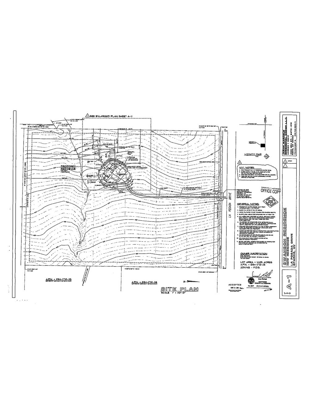
5 Washoe County Parcel Map Review Committee Staff Report Date: February 18, 2015 Site Plan Parcel Map Case Number Page 5 of 10 SWANSON FAMILY TRUST
6 Washoe County Parcel Map Review Committee Staff Report Date: February 18, 2015 Tentative Parcel Map Evaluation Land Use Designation: Maximum Lot Potential: 41 Number of Lots on Parcel Map: 4 Minimum Lot Size Required: Minimum Lot Size on Parcel Map: Minimum Lot Width Required: Medium Density Suburban 12,000 square feet (±0.28 acres) ±1.47 acres 80 feet Minimum Lot Width on Parcel Map: 200 feet The tentative parcel map meets all minimum requirements for the Medium Density Suburban (MDS) regulatory zone. Development Suitability Constraints: The Spanish Springs Development Suitability Map, a part of the Spanish Springs Area Plan, identifies the subject parcel as unconstrained. Hydrographic Basin: The subject parcel is within the Spanish Springs Hydrographic Basin. The subject parcel is inside the Truckee Meadows Service Area (TMSA). Spanish Springs Area Plan Modifiers Section Buffers. A minimum twenty-five (25) foot open space/scenic view buffer shall be provided on parcels along all arterial rights-of-way (La Posada), measured in from the street edge property line. No fences, walls or structures shall be permitted in the buffer areas. Such buffer areas shall be included in the calculation of allowable density. Section Spanish Springs Water Detention Facility. All proposed development in the Spanish Springs planning area shall evaluate and develop storm drainage improvements which ensure the Spanish Springs Water Detention Facility remains hydraulically equivalent to the design parameters of the facility existing at the time of adoption of this section. Development Information The subject parcel is developed with a single family house. The required setbacks for Medium Density Suburban are 20 feet for front and rear yard setbacks and 8 feet for the side yard setbacks. The single family dwelling and all structures meet the above-mentioned setbacks. Reviewing Agencies The following agencies received a copy of the project application for review and evaluation: Washoe County Community Services Department o Planning and Development Division o Engineering and Capital Projects Division Washoe County Health District o Environmental Health Division o Vector-Borne Diseases Division Truckee Meadows Fire Protection District Parcel Map Case Number Page 6 of 10 SWANSON FAMILY TRUST
7 Washoe County Parcel Map Review Committee Staff Report Date: February 18, 2015 Truckee Meadows Water Authority Regional Transportation Commission City of Sparks Washoe County School District Seven out of the nine above listed agencies/departments provided comments and/or recommended Conditions of Approval in response to their evaluation of the project application. A summary of each agency s comments and/or recommended conditions of approval and their contact information is provided. The Conditions of Approval document is attached to this staff report and will be included with the Action Order. Planning and Development requires that the new lot created around the existing house shall conform to MDS setbacks, and the final map be in substantial compliance with all plans and documents submitted with the tentative parcel map. Contact: Eva Krause, , ekrause@washoecounty.us Engineering and Capital Projects Division provided conditions addressing the final parcel map, easements and street improvements. Contact: Mike Gump, PLS, , mgump@washoecounty.us Environmental Health Division stated that parcel 1 cannot be divided to less than five acre parcels until sewer service is provided. Contact: Chris Anderson, PE, , canderson@washoecounty.us Truckee Meadows Fire Protection District stated that WUI fire codes apply and homes may require a fire suppression system. Contact: Amy Ray, Fire Marshal, , ARay@tmfpd.us Truckee Meadows Water Authority stated that water rights are required at time of development. Contact: Levi Kleiber, Supervisor, Land and Mapping Services, , lkeiber@tmwa.com City of Sparks Community Services/Planning Division placed limits and conditions for access to La Posada and drainage from the property. Contact: Karen Melby, , Kmelby@cityofsparks.us Washoe County School District stated that the property is in the School Districts service area, but they cannot guarantee that residents of the parcel map will be assigned to schools in the Spanish Springs area. Contact: Mike Boster, School Planner, , MBoster@washoeschools.net Staff Comment on Required Findings Washoe County Development Code Section (i) of Article 606, Parcel Maps, requires that all of the following findings be made to the satisfaction of the Washoe County Parcel Map Review Committee before granting approval of the request. Staff has completed an analysis of the application and has determined that the proposal is in compliance with the required findings as follows. Parcel Map Case Number Page 7 of 10 SWANSON FAMILY TRUST
8 Washoe County Parcel Map Review Committee Staff Report Date: February 18, ) General improvement considerations for all parcel maps including, but not limited to: a) Environmental and health laws and regulations concerning water and air pollution, the disposal of solid waste, facilities to supply water, community or public sewage disposal and, where applicable, individual systems for sewage disposal. Staff Comment: This is the first parcel map for this property, therefore Environment Heath regulations will permitted the four parcels to have septic systems. b) The availability of water which meets applicable health standards and is sufficient for the reasonably foreseeable needs of the subdivision. Staff Comment: The property is within the Truckee Meadows Water Authority s service area. Water rights for the new parcels are required to be dedicated prior to development of the properties. c) The availability and accessibility of utilities. Staff Comment: Utility services are available and accessible. d) The availability and accessibility of public services such as schools, police and fire protection, transportation, recreation and parks. Staff Comment: The area is served by police and fire. There are recreation and park facilities within the Spanish Springs area. The area is serviced by the Washoe County School District (WCSD). Due to WCSD funding and maintenance issues and school overcrowding, students may not be able to attend the schools zoned for this area. e) Conformity with the zoning ordinances and master plan. Staff Comment: The proposed parcel map does conform to zoning and master plan standard. f) General conformity with the governing body s master plan of streets and highways. Staff Comment: The proposed parcel map provides street access to the regional street network. g) The effect of the proposed subdivision on existing public streets and the need for new streets or highways to serve the subdivision. Staff Comment: The proposed parcel map s private street does not adversely affect the existing street network and does not create a need for more public streets or highways. h) Physical characteristics of the land such as floodplain, slope and soil. Staff Comment: The site is relatively flat and is not located in a flood plain, and does not have any development constraints. i) The recommendations and comments of those entities reviewing the tentative parcel map pursuant to NRS and , inclusive. Staff Comment: The Conditions of Approval include the conditions submitted by the reviewing agencies. j) The availability and accessibility of fire protection including, but not limited to, the availability and accessibility of water and services for the prevention and containment of fires including fires in wild lands. Parcel Map Case Number Page 8 of 10 SWANSON FAMILY TRUST
9 Washoe County Parcel Map Review Committee Staff Report Date: February 18, 2015 Staff Comment: The Truckee Meadows Fire Protection District requires that development conform to the International Wildland and Urban Interface codes and that residential structures may require fire suppression systems. k) Community antenna television (CATV) conduit and pull wire. Staff Comment: A 10-foot public utility easement is dedicated on all sides of each parcel. l) Recreation and trail easements. Recommendation Staff Comment: The parcels are surrounded by residential development on three sides. There are no opportunities for recreational activities adjacent to the project therefore, no trail easements are included or required. Those agencies which reviewed the application, recommended conditions in support of approval of the tentative parcel map. Therefore, after a thorough analysis and review of Parcel Map Case Number, it is recommended for approval with conditions. Staff offers the following motion for the Parcel Map Review Committee s consideration. Review Criteria I move that, after giving reasoned consideration to the information contained within the staff report and the information received during the public meeting, that the Washoe County Parcel Map Review Committee approve Parcel Map Case Number for Eric and Rebecca Swanson which has determined that the following criteria is or will be adequately provided for pursuant to Washoe County Development Code, Section : General improvement considerations for all parcel maps including, but not limited to: a) Environmental and health laws and regulations concerning water and air pollution, the disposal of solid waste, facilities to supply water, community or public sewage disposal and, where applicable, individual systems for sewage disposal; b) The availability of water which meets applicable health standards and is sufficient for the reasonably foreseeable needs of the subdivision; c) The availability and accessibility of utilities; d) The availability and accessibility of public services such as schools, police and fire protection, transportation, recreation and parks; e) Conformity with the zoning ordinances and master plan; f) General conformity with the governing body s master plan of streets and highways; g) The effect of the proposed subdivision on existing public streets and the need for new streets or highways to serve the subdivision; h) Physical characteristics of the land such as floodplain, slope and soil; i) The recommendations and comments of those entities reviewing the tentative parcel map pursuant to NRS and , inclusive; j) The availability and accessibility of fire protection including, but not limited to, the availability and accessibility of water and services for the prevention and containment of fires including fires in wild lands; Parcel Map Case Number Page 9 of 10 SWANSON FAMILY TRUST
10 Washoe County Parcel Map Review Committee Staff Report Date: February 18, 2015 k) Community antenna television (CATV) conduit and pull wire; and l) Recreation and trail easements. Appeal Process For 30 days following the notification of decision, the decision of the Parcel Map Review Committee may be appealed to the Board of County Commissioners. xc: Applicant/Property Owner: Eric and Rebecca Swanson Representatives: Dennis Chapman, Landmark Surveying Staff Report xc: Parcel Map Review Committee; Karen Melby, City of Sparks Planning; Levi Kleiber, Truckee Meadows Water Authority, Parcel Map Case Number Page 10 of 10 SWANSON FAMILY TRUST
11 Conditions of Approval Parcel Map Case Number The tentative parcel map approved under Parcel Map Case Number shall be carried out in accordance with the Conditions of Approval granted by the Washoe County Parcel Map Review Committee on March 12, Conditions of Approval are requirements placed on a permit or development by each reviewing agency. These Conditions of Approval may require submittal of documents, applications, fees, inspections, amendments to plans, and more. These conditions do not relieve the applicant of the obligation to obtain any other approvals and licenses from relevant authorities required under any other act. Unless otherwise specified, all conditions related to the approval of this tentative parcel map shall be met or financial assurance must be provided to satisfy the conditions of approval prior to the recordation of a final parcel map. The agency responsible for determining compliance with a specific condition shall determine whether the condition must be fully completed or whether the applicant shall be offered the option of providing financial assurance. All agreements, easements, or other documentation required by these conditions shall have a copy filed with the County Engineer and the Planning and Development Division. Compliance with the conditions of approval related to this tentative parcel map is the responsibility of the applicant, his/her successor in interest, and all owners, assignees, and occupants of the property and their successors in interest. Failure to comply with any of the conditions imposed in the approval of the tentative parcel map may result in the institution of revocation procedures. Washoe County reserves the right to review and revise the Conditions of Approval related to this tentative parcel map should it be determined that a subsequent license or permit issued by Washoe County violates the intent of this approval. For the purpose of conditions imposed by Washoe County, may is permissive and shall or must is mandatory. Conditions of Approval are usually complied with at different stages of the proposed project. Those stages are typically: Prior to recordation of a final map. Prior to obtaining a final inspection and/or a certificate of occupancy. Prior to the issuance of a business license or other permits/licenses. Some Conditions of Approval are referred to as Operational Conditions. These conditions must be continually complied with for the life of the project. The Washoe County Commission oversees many of the reviewing agencies/departments with the exception of the following agencies. The DISTRICT BOARD OF HEALTH, through the Washoe County Health District, has jurisdiction over all public health matters in the Health District. Any conditions set by the District Health Department must be appealed to the District Board of Health. The City of Sparks has jurisdiction over matters that affect properties within the City s boundaries and Spark s Sphere of Influence. Any conditions set by the City of Sparks must be appealed to the City. Post Office Box 11130, Reno, NV E. Ninth St., Reno, NV Telephone: Fax: EXHIBIT A
12 Washoe County Parcel Map Review Committee Conditions of Approval Truckee Meadows Water Authority has jurisdiction over water service matters. Any conditions set by TMWA must be appealed to TMWA. FOLLOWING ARE CONDITIONS OF APPROVAL REQUIRED BY THE REVIEWING AGENCIES. EACH CONDITION MUST BE MET TO THE SATISFACTION OF THE ISSUING AGENCY. Planning and Development 1. The following conditions are requirements of the Planning and Development Division, which shall be responsible for determining compliance with these conditions. Contact: Eva M. Krause, AICP, Planner, , a. The final map shall be in substantial compliance with all plans and documents submitted as part of this tentative parcel map application, and with any amendments imposed by the Parcel Map Review Committee. All documentation necessary to satisfy the conditions noted below shall accompany the final map when submitted to the County Engineer and the Planning and Development Division. b. The applicant shall comply with all the conditions of approval and shall submit a final map for signature by the Director of the Planning and Development Division within 22 months from the date of approval by the Parcel Map Review Committee. Each agency responsible for imposing conditions may determine whether its conditions must be fully completed or whether the applicant shall be offered the option of providing financial assurances as a means of assuring compliance. c. The final map shall contain the following jurat: DIRECTOR OF PLANNING AND DEVELOPMENT CERTIFICATE THE FINAL PARCEL MAP CASE NO. MEETS ALL APPLICABLE STATUTES, ORDINANCES AND CODE PROVISIONS; IS IN SUBSTANTIAL CONFORMANCE WITH THE TENTATIVE MAP AND ITS CONDITIONS, WHICH ARE INCORPORATED HEREIN BY THIS REFERENCE, AND THOSE CONDITIONS HAVE BEEN SATISFIED FOR RECORDATION OF THIS MAP. THE OFFER(S) OF DEDICATION IS (ARE) REJECTED AT THIS TIME, BUT WILL REMAIN OPEN IN ACCORDANCE WITH NEVADA REVISED STATUTES CHAPTER 278. THIS FINAL MAP IS APPROVED AND ACCEPTED THIS DAY OF, 20, BY THE DIRECTOR OF PLANNING AND DEVELOPMENT OF WASHOE COUNTY, NEVADA, IN ACCORDANCE WITH NEVADA REVISED STATUTES THROUGH WILLIAM WHITNEY (OR LEAGEL SUCCESSOR), DIRECTOR, PLANNING AND DEVELOPMENT DIVISION d. The Final Parcel Map shall contain the following note: The property owner(s) of parcels 1, 3 and 4 shall be responsible for providing water rights sufficient to serve the use proposed for the parcel, as Parcel Map Case Number Page 2 of 5 EXHIBIT A
13 Washoe County Parcel Map Review Committee Conditions of Approval determined by TMWA. All parcels are required to comply with TMWA requirements at the time of applying for a building permit. e. Any regulations, procedures, and conditions adopted by the Washoe County District Health Department must be met prior to recordation of a final map. f. The applicant shall provide verification to the Planning and Development Division that all conditions from the Truckee Meadows Fire Protection District have been satisfied. g. The applicant has indicated that the proposed improvements will not exceed the major grading thresholds that require a special use permit. If the final construction drawings for the map include grading that exceeds the Major Grading Permit Thresholds listed in Article 438, Grading Standards, the applicant shall apply for a special use permit for grading; and if approved, may be delayed up to three months processing time. In addition, all related standards within the Washoe County Development Code shall be met on the construction drawings. Compliance shall be determined by the Planning and Development Division. h. The approval for this tentative parcel map does not include improvements for driveways to building pads. Grading for access to building pads, if they exceed the criteria stated in the previous condition, shall require a Special Use Permit. Compliance shall be determined by the Planning and Development Division. i. Any regulations, procedures, and conditions adopted by Washoe County Health District must be met prior to recordation of a final map. j. Per the Spanish Springs Area regulations, Section Buffers, a minimum twenty-five (25) foot open space/scenic view buffer shall be provided on parcels along all arterial rights-of-way (La Posada), measured in from the street edge property line. No fences, walls or structures shall be permitted in the buffer areas. Such buffer areas shall be included in the calculation of allowable density. k. Per the Spanish Springs Area regulations, Section Spanish Springs Water Detention Facility, all proposed development in the Spanish Springs planning area shall evaluate and develop storm drainage improvements which ensure the Spanish Springs Water Detention Facility remains hydraulically equivalent to the design parameters of the facility existing at the time of adoption of this section. Engineering and Capital Projects 2. The following conditions are requirements of the Engineering and Capital Projects, which shall be responsible for determining compliance with these conditions. Contact: Mike Gump, PLS, , mgump@washoecounty.us a. Provide approval from City of Sparks for access off of La Posada right of way. b. Add Drainage to all new easements. c. Increase the 20 Drainage Easement in Parcel 1 to 60. d. Add a 20 wide Access Easement on Parcel 1 from the end of the cul-de-sac over the gravel road to the 20 PUE and Access Easement on Lot 17 of Tract Map e. Remove structures from the map. f. Add a Water Rights Dedication Certificate. Parcel Map Case Number Page 3 of 5 EXHIBIT A
14 Washoe County Parcel Map Review Committee Conditions of Approval g. Street improvement is a condition of this map. Prior to final approval and recordation provide construction drawings, including profile grades, street cross-sections, culvert locations, drainage patterns and improvements. Street signs and centerline street monuments must be installed. An asphalt roadway with curb and gutter shall be constructed (per Standard Details for Public Works Construction under Washoe Drawing No. W-1.3, W-1.4 ). The plans shall include sufficient drainage improvements to provide for runoff. Upon approval of the aforementioned construction drawings, a bond or letter of credit for 140% of the estimated cost must be submitted to Washoe County to insure the completion of the proposed plans. The applicant must also complete a Parcel Map Improvement Agreement (Subdivision Improvement Agreement) with Washoe County prior to final approval and recordation of the map. h. Provide a plan for surface drainage for review and approval. Provide engineering design of culvert crossing. i. Add a drainage easement for surface drainage. j. Show parcel areas in square feet when under 2 acres. k. Comply with the conditions of the Washoe County technical check for this map. l. Add a Security Interest Holder s Certificate to the map if applicable. m. Grant easements for snow storage and signage along La Posada Drive. Truckee Meadow Water Authority 3. The following conditions are requirements of Truckee Meadows Water Authority, which shall be responsible for determining compliance with these conditions. Contact: Levi Kleiber, Supervisor, Land and Mapping Services, , lkeiber@tmwa.com a. With the development of each parcel and prior to the issuance of any building permit for said parcel, the owner shall dedicate water rights to the servicing utility sufficient to serve the development and shall provide Washoe County with a Will Serve letter. Washoe County District Health 4. The following conditions are requirements of Washoe County District Health, which shall be responsible for determining compliance with these conditions. The District Board of Health has jurisdiction over all public health matters in Washoe County District Health. Any conditions set by Washoe County District Health must be appealed to the District Board of Health. Contact: Chris Anderson, PE, , canderson@washoecounty.us a. The following note shall be added to the Parcel Map: Parcel 1 is a remainder parcel and shall not be further divided at less than 5 acres until such time as Public Water and Public Sewer are available. Parcel Map Case Number Page 4 of 5 EXHIBIT A
15 Washoe County Parcel Map Review Committee Conditions of Approval City of Sparks Community Services/Planning Division 5. The following conditions are requirements of the City of Sparks Community Services/Planning division, which shall be responsible for determining compliance with these conditions. Contact: Karen L. Melby, AICP, Senior Planner, , a. The access of the lots is restricted to the cul-de-sac and there is no direct access off La Posada. The cul-de-sac is either private or county maintained. b. The access of the cul-de-sac off La Posada shall comply with the RTP Control of Access standards. c. Any access to the services in La Posada requires a street cut permit. d. The site drainage must meet the minimum for the Washoe County Drainage Manual. Truckee Meadows Fire Protection District 6. The following conditions are requirements of the Truckee Meadows Fire Protection District, which shall be responsible for determining compliance with these conditions. Contact: Amy Ray, Fire Marshal, , ARay@tmfpd.us a. All parcels are subject to the requirements of Washoe County Code 60, including all requirements under the International Wildland Urban Interface Code. b. Residences built on these lots may require the installation of a residential fire suppression system dependent on square footage and water supply provided. *** End of Conditions *** Parcel Map Case Number Page 5 of 5 EXHIBIT A

16 Washoe County COMMUNITY SERVICES DEPARTMENT Engineering and Capital Projects INTEROFFICE MEMORANDUM DATE: February 17, 2015 PARCEL MAP REVIEW TO: FROM: Department of Community Services, Eva Krause Mike Gump, PLS, Engineering Division SUBJECT: Parcel Map for: Swanson, Eric Parcel Map Case No.: APN: Review Date: 02/13/2015 Existing Zoning/Land Use Designation: The Engineering Division has reviewed the subject parcel map and the following conditions must be successfully completed prior to final approval of this application by the Engineering Division. 1. Provide approval from City of Sparks for access off of La Posada right of way. 2. Add Drainage to all new easements. 3. Increase the 20 Drainage Easement in Parcel 1 to Add a 20 wide Access Easement on Parcel 1 from the end of the cul-de-sac over the gravel road to the 20 PUE and Access Easement on Lot 17 of Tract Map Remove structures from the map. 6. Add a Water Rights Dedication Certificate. 7. Street improvement is a condition of this map. Prior to final approval and recordation provide construction drawings, including profile grades, street cross-sections, culvert locations, drainage patterns and improvements. Street signs and centerline street monuments must be installed. An asphalt roadway with curb and gutter shall be constructed (per Standard Details for Public Works Construction under Washoe Drawing No. W-1.3, W- 1.4 ). The plans shall include sufficient drainage improvements to provide for runoff. Upon approval of the aforementioned construction drawings, a bond or letter of credit for 140% of the estimated cost must be submitted to Washoe County to insure the completion of the proposed plans. The applicant must also complete a Parcel Map Improvement Agreement (Subdivision Improvement Agreement) with Washoe County prior to final approval and recordation of the map. 8. Provide a plan for surface drainage for review and approval. Provide engineering design of culvert crossing. 9. Add a drainage easement for surface drainage E. 9 TH Street P.O. Box 11130, Reno, Nevada Phone (775) Fax (775) EXHIBIT B


17 10. Show parcel areas in square feet when under 2 acres. 11. Comply with the conditions of the Washoe County technical check for this map. 12. Add a Security Interest Holder s Certificate to the map if applicable. 13. Grant easements for snow storage and signage along La Posada Drive. February 18, 2015 WASHOE COUNTY HEALTH DISTRICT Eva Krause, Planner Washoe County Community Services Planning and Development Division PO Box Reno, NV RE: Parcel Map for Swanson Family Trust; APN Parcel Map Dear Mrs. Krause: The Washoe County Health District, Environmental Health Services Division has reviewed the above referenced project. Approval by this Division is subject to the following condition: 1. The following note shall be added to the Parcel Map: a. Parcel 1 is a remainder parcel and shall not be further divided at less than 5 acres until such time as Public Water and Public Sewer are available. If you have any questions regarding the foregoing, please call me at Sincerely, Chris Anderson, P.E. Registered Engineer Environmental Health Services CA/WR:ca Cc: Dennis Chapman, PLS Landmark Surveying EXHIBIT B
18 February 17, 2015 Washoe County Community Services Department 1001 East Ninth Street Reno, NV Re: Parcel Map Case No. - Swanson Family Trust The Truckee Meadows Fire Protection District (TMFPD) will approve the parcel map, providing the following information and conditions: All parcels are subject to the requirements of Washoe County Code 60, including all requirements under the International Wildland Urban Interface Code. Residences built on these lots may require the installation of a residential fire suppression system dependent on square footage and water supply provided. Please contact me with any questions at (775) Thank you, Amy Ray Fire Marshal EXHIBIT B
19 From: Melby, Karen Sent: Wednesday, February 11, :37 PM To: Krause, Eva Subject: Parcel Map Case Eva, The City of Sparks has the following comments on the above referenced parcel map: 1. The access of the lots is restricted to the cul-de-sac and there is no direct access off La Posada. The cul-de-sac is either private or County maintained. 2. The access of the cul-de-sac off La Posada comply with the RTP Control of Access standards. 3. Any access to the services in La Posada requires a street cut permit. 4. The site drainage must meet the minimum for the Washoe County Drainage Manual. This concludes the City s comments. Thanks for the opportunity to commenting. Any questions, do not hesitate to contact me. Karen L. Melby, AICP / Senior Planner City of Sparks Community Services / Planning Division 431 Prater Way, Sparks, NV Tel: Fax: kmelby@cityofsparks.us From: Boster, Mike <MBoster@washoeschools.net> Sent: Tuesday, February 17, :14 PM To: Krause, Eva Subject: FW: February Agency Review Memo-Swanson Family Trust Attachments: February Agency Review Memo.pdf Hi Eva, This property is zoned for the following schools: Spanish Springs ES Base Capacity = Enrollment = 713 Shaw MS Base Capacity = Enrollment = 1008 Spanish Springs HS Base Capacity = Enrollment = 2315 Due to an uncertain funding source for school maintenance and new construction, WCSD cannot guarantee that students assigned to a particular school will be able to attend that school due to overcrowding. We hope to have additional information after the 2015 Nevada Legislature completes this session. EXHIBIT B
20 I hope this is helpful. Thank you for the opportunity to comment. Mike Michael S. Boster School Planner Washoe County School District Capital Projects Old Virginia Road Reno NV From: Kleiber, Levi (TMWA) Sent: Wednesday, February 18, :27 AM To: Krause, Eva Cc: Crook, Elizabeth; Edmunson, Heather Subject: Water Right Dedication verbiage for non-subdvsn maps Eva, As discussed, we do not require the dedication of water rights on parcel maps, only at the time of development of the parcel. Below is the language we require on parcel maps. With the development of each parcel and prior to the issuance of any building permit for said parcel, the owner shall dedicate water rights to the servicing utility sufficient to serve the development and shall provide the City of Reno with a Will Serve letter. I have copied Elizabeth Crook, Water Right Administrator and Heather Edmunson, Land Agent on this . We ve been fielding several questions on this issue. If needed, It may be beneficial to meet and discuss. Thank you Levi Kleiber Supervisor, Lands & Mapping Services Truckee Meadows Water Authority 1355 Capital Blvd. I Reno, NV O: (775) , M: (775) lkleiber@tmwa.com I EXHIBIT B
21 EXHIBIT C
22 EXHIBIT C
23 EXHIBIT C
24 EXHIBIT C
25 EXHIBIT C
26 EXHIBIT C
27 EXHIBIT C
28 EXHIBIT C
29 EXHIBIT C
Parcel Map Review Committee Staff Report Meeting Date: October 13, 2016
 Subject: Applicant: Agenda Item Number: Project Summary: Recommendation: Parcel Map Review Committee Staff Report Meeting Date: October 13, 2016 Parcel Map Case Number Spanish Springs Associates Ltd. Ptsp.
Parcel Map Review Committee Staff Report Meeting Date: October 8, 2015
 Parcel Map Review Committee Staff Report Meeting Date: October 8, 2015 Subject: Applicant: Agenda Item Number: Project Summary: Recommendation: Parcel Map Case Number Reeves Business Ventures 7D Divide
Parcel Map Review Committee Staff Report Meeting Date: May 12, 2016
 Subject: Applicant: Agenda Item Number: Project Summary: Recommendation: Parcel Map Review Committee Staff Report Meeting Date: May 12, 2016 Tentative Parcel Map Case Number TL Mt. Rose Estates, LP 7C
Parcel Map Review Committee Staff Report Meeting Date: March 12, 2015
 Subject: Applicant(s): Agenda Item Number: Parcel Map Review Committee Staff Report Meeting Date: March 12, 2015 Parcel Map Case Number William and Maryanne Paganetti 7B Project Summary: Dividing a 14.2
Parcel Map Review Committee Staff Report
 Parcel Map Review Committee Staff Report Meeting Date: October 11, 2018 Agenda Item: 7A TENTATIVE PARCEL MAP CASE NUMBER: (Larkins) BRIEF SUMMARY OF REQUEST: Request to divide one parcel of ±1.084-acres
DRAFT. 1. Determination of Quorum Eric Young called the meeting to order at 1:31 p.m. The following members and staff were present:
 WASHOE COUNTY PARCEL MAP REVIEW COMMITTEE Meeting Minutes Parcel Map Review Committee Members Thursday, December 8, 2016 1:30 p.m. James Barnes, Planning Commission James English, Health District Tim Simpson,
Parcel Map Review Committee Staff Report Meeting Date: April 13, 2017
 Parcel Map Review Committee Staff Report Meeting Date: April 13, 2017 Subject: Applicant: Agenda Item Number: Project Summary: Recommendation: Prepared by: Parcel Map Case Number Christy Corporation 7A
Administrative Permit Staff Report Meeting Date: February 2, 2017
 Administrative Permit Staff Report Meeting Date: February 2, 2017 Subject: Applicant: Agenda Item Number: Summary: Recommendation: Administrative Permit Case Number WADMIN16-0001 Carlson and Associates
Board of Adjustment Staff Report Meeting Date: June 1, 2017
 Board of Adjustment Staff Report Meeting Date: June 1, 2017 Subject: Applicant: Agenda Item Number: Summary: Recommendation: Prepared by: Phone: E-Mail: Administrative Permit Case Number Powning Family
Board of Adjustment Staff Report Meeting Date: April 4, 2013
 Board of Adjustment Staff Report Meeting Date: April 4, 2013 Subject: Applicant(s): Agenda Item No. Project Summary: Recommendation: Prepared by: Variance Case No: VA13-001 Gary R. Taylor on behalf of
Parcel Map Review Committee Staff Report Meeting Date: June 8, 2017
 Parcel Map Review Committee Staff Report Meeting Date: June 8, 2017 Subject: Applicant/Owner: Agenda Item Number: Project Summary: Recommendation: Parcel Map Case Number Dyke and Beth Kauffmann 7C Divide
Detached Accessory Dwelling Administrative Review Staff Report Date: August 26, 2014
 Detached Accessory Dwelling Administrative Review Staff Report Subject: Detached Accessory Dwelling Administrative Review Case No: DADAR14-04 Applicant(s): Nick Gibson Summary: To establish a Detached
Board of Adjustment Staff Report Meeting Date: February 5, 2015
 Board of Adjustment Staff Report Meeting Date: February 5, 2015 Subject: Applicants: Agenda Item Number Project Summary: Recommendation: Variance Case Number: Lawrence and Judith Romiti 7A Reduce the front
Planning Commission Staff Report Meeting Date: September 6, 2016
 Planning Commission Staff Report Meeting Date: September 6, 2016 Subject: Applicant(s): Agenda Item Number: Project Summary: Recommendation: Tentative Subdivision Map Case Number: Spanish Springs Associates,
LYON COUNTY COMMUNITY DEVELOPMENT DEPARTMENT
 LYON COUNTY COMMUNITY DEVELOPMENT DEPARTMENT B UILDING D EVELOPMENT E NGINEERING P LANNING 27 S. MAIN S TREET Y ERINGTON, NEVADA 89447 (775) 463-6591 F AX: (775) 463-5305 34 LAKES B OULEVARD D AYTON, NEVADA
Memorandum: October 13, 2008 REVISED To: Trowbridge Township Planning Commission From: P. Hudson, AICP Re: Suggested New Ordinance
 1 Memorandum: October 13, 2008 REVISED 2-11-09 To: Trowbridge Township Planning Commission From: P. Hudson, AICP Re: Suggested New Ordinance Because of changes in both the Michigan Planning Enabling Act
Planning Commission Staff Report Meeting Date: February 2, 2016
 Planning Commission Staff Report Meeting Date: February 2, 2016 Subject: Applicant(s): Agenda Item Number: Summary: Recommendation: Abandonment Case Number Gary and Rachel Bullock 9B To allow the abandonment
ELK RAPIDS TOWNSHIP ANTRIM COUNTY, MICHIGAN ORDINANCE NO
 ELK RAPIDS TOWNSHIP ANTRIM COUNTY, MICHIGAN ORDINANCE NO. 3-2011 AN ORDINANCE TO REPLACE THE SUBDIVISION CONTROL ORDINANCE WITH A NEW SUBDIVISION DEVELOPMENT ORDINANCE, IN ACCORD WITH THE LAND DIVISION
Lake County Planning, Building and Development Department
 SUBMISSION CHECKLIST FOR SUBDIVISION FINAL PLAT Lake County Planning, Building and Development Department 500 W. Winchester Rd. Unit 101 Libertyville, Illinois 60048-1331 Telephone (847) 377-2600 E-mail:
Tentative Map Application Review Procedures
 FOR REFERENCE ONLY This page is not part of the application. Tentative Map Application Review Procedures The tentative map process in Churchill County is designed to provide a mechanism in order to divide
Chapter 100 Planned Unit Development in Corvallis Urban Fringe
 100.100 Scope and Purpose. Chapter 100 Planned Unit Development in Corvallis Urban Fringe (1) All applications for land divisions in the Urban Residential (UR) and Flood Plain Agriculture (FPA) zones within
PRELIMINARY PLAT Checklist
 PRELIMINARY PLAT Checklist 3715 Bridgeport Way W University Place, WA 98466 PH: (253) 566-5656 FAX: (253) 460-2541 This is a checklist of materials required for a Preliminary Plat. This checklist is provided
LYON COUNTY TITLE 15 LAND USE AND DEVELOPMENT CODE LAND DIVISION REGULATIONS CHAPTERS October 19, 2017 Ordinance Draft DRAFT
 DRAFT LYON COUNTY TITLE 15 LAND USE AND DEVELOPMENT CODE LAND DIVISION REGULATIONS CHAPTERS 15.600 15.607 October 19, 2017 Ordinance Draft This page left blank intentionally DRAFT DRAFT Lyon County Contents
TENTATIVE PARCEL MAP APPLICATION GUIDE TENTATIVE PARCEL MAP APPLICATION REQUIREMENTS
 TENTATIVE PARCEL MAP APPLICATION GUIDE SISKIYOU COUNTY PLANNING DIVISION 806 South Main Street, Yreka CA 96097 Phone: (530) 841-2100 / Fax: (530) 841-4076 TENTATIVE PARCEL MAP APPLICATION REQUIREMENTS
THE CI FY OF MOBILE, ALABAMA
 THE CI FY OF MOBILE, ALABAMA LETTER OF DECISION DewberryiPreble-Rish 9949 Bellaton Avenue Daphne, AL 36526 Re: Area bounded by Foxtail Drive, Lace Bark Drive and Whitebark Drive Council District 6 SUB-000323-2017
NYE COUNTY, NV PAHRUMP REGIONAL PLANNING COMMISSION REGULAR MEETING JANUARY 11, 2017
 CASE DESCRIPTION(S): LOCATION: APN NUMBER(S): AP# 045-021-59 NYE COUNTY, NV PAHRUMP REGIONAL PLANNING COMMISSION REGULAR MEETING JANUARY 11, 2017 a. For Possible Action TM-2016-00004: Tentative Map application
Time Extension Staff Report
 Time Extension Staff Report Subdivision Name Lunara Subdivision File Number SUB07-00019 Approval Time Extension for Lead Agency Boise City Certification Signature of Boise City Engineer Annexation Date
This Ordinance is adopted under the authority and provisions of the General Statutes of North Carolina, Article 6, Chapter 153A 121.
 Section 74, Regulations Governing Manufactured Home Parks 1. Purpose The purpose of these regulations to be known and cited as the Madison County Manufactured Home Park Ordinance is to regulate and guide
ARTICLE 24 SITE PLAN REVIEW
 ARTICLE 24 SITE PLAN REVIEW 24.1 PURPOSE: The intent of these Ordinance provisions is to provide for consultation and cooperation between the land developer and the Township Planning Commission in order
TOWNSHIP OF DOYLESTOWN APPLICATION FOR REVIEW OF SUBDIVISION OR LAND DEVELOPMENT PROPOSAL. Please PRINT; all information MUST be filled out completely
 TOWNSHIP OF DOYLESTOWN APPLICATION FOR REVIEW OF SUBDIVISION OR LAND DEVELOPMENT PROPOSAL Please PRINT; all information MUST be filled out completely Date: Name of Subdivision or Land Development: Location:
ARTICLE 1 GENERAL PROVISIONS
 ARTICLE 1 GENERAL PROVISIONS SECTION 100 TITLE This Ordinance shall be known and cited as the "Rice Township Subdivision and Land Development Ordinance." SECTION 101 AUTHORITY Rice Township is empowered
WASHINGTON COUNTY CUP SUBMITTAL CHECKLIST
 WASHINGTON COUNTY CUP SUBMITTAL CHECKLIST The following must be turned in to the Planning Office by the submittal date for your CUP to be reviewed by the Planning Board. (Incomplete applications will not
Planning Department Oconee County, Georgia
 Planning Department Oconee County, Georgia STAFF REPORT REZONE CASE #: 6985 DATE: October 31, 2016 STAFF REPORT BY: Andrew C. Stern, Planner APPLICANT NAME: Williams & Associates, Land Planners PC PROPERTY
Waseca County Planning and Zoning Office
 Waseca County Planning and Zoning Office 300 North State Street Waseca, Minnesota 56093 Phone: 507-835-0650 Fax: 507-837-5310 Form no. PZ 081009 Web Site: www.co.waseca.mn.us FEES: 1) CUP FEE- $400.00
TOWN OF LEWISTON PLANNING BOARD APPLICATION
 TOWN OF LEWISTON PLANNING BOARD APPLICATION DESCRIPTION OF PROPOSED REQUEST: Name of Property Owner: Phone #: Name of Applicant:Phone #: Address or Location of Proposal:_SBL# Size of Parcel or Structure:Existing
SHORT PLAT Information
 Information This form provides information and an explanation of the procedures of a Short Plat. If you have any questions, contact the Planning and Development Services Department at (253) 566-5656. A
PLANNED UNIT DEVELOPMENT & SUBDIVISION STAFF REPORT Date: November 17, 2016
 PLANNED UNIT DEVELOPMENT & SUBDIVISION STAFF REPORT Date: November 17, 2016 DEVELOPMENT NAME SUBDIVISION NAME LOCATION Autonation Ford of Mobile Autonation Ford of Mobile Subdivision 901, 909, and 925
Chapter Plat Design (LMC)
") Chapter 18.14 Plat Design (LMC) Sections: 18.14.010 Lot width 18.14.020 Right-of-way requirements 18.14.030 Pipe stem lots 18.14.040 Division resulting in minimum lot sizes 18.14.050 Flood prone and bad
Chapter 18.14 Plat Design (LMC) Sections: 18.14.010 Lot width 18.14.020 Right-of-way requirements 18.14.030 Pipe stem lots 18.14.040 Division resulting in minimum lot sizes 18.14.050 Flood prone and bad
Residential Major Subdivision Review Checklist
 Residential Major Subdivision Review Checklist Plan Submittal Requirements: 2 full sets of stamped plans Electric submittal - all plans contained in a single PDF 3 full sets if commercial kitchen or dining
APPLICATION PROCEDURE
 ANTRIM PLANNING BOARD P. O. Box 517 Antrim, New Hampshire 03440 Phone: 603-588-6785 FAX: 603-588-2969 APPLICATION FORM AND CHECKLIST FOR MINOR OR MAJOR SITE PLAN REVIEW File Date Received By APPLICATION
SUBMITTAL REQUIREMENTS: The number indicates the number of copies for submittal (if applicable).
.") Office Use Only Preliminary Long Plat Long Subdivision Applicant Checklist PLANNING, COMMUNITY, & ECONOMIC DEVELOPMENT DEPARTMENT PRELIMINARY LONG PLAT LONG SUBDIVISION CHECKLIST Mailing Address: P.O.
Office Use Only Preliminary Long Plat Long Subdivision Applicant Checklist PLANNING, COMMUNITY, & ECONOMIC DEVELOPMENT DEPARTMENT PRELIMINARY LONG PLAT LONG SUBDIVISION CHECKLIST Mailing Address: P.O.
CITY OF FERNDALE HEARING EXAMINER
 CITY OF FERNDALE HEARING EXAMINER RE: Planned Unit Development ) 16001-PUD Preliminary Plat ) 16018-SE Plat Variance ) 16002-VAR Application by ) ) MD General, L.L.C. ) FINDINGS OF FACT, Malloy Heights
ARTICLE SINGLE FAMILY SITE CONDOMINIUM DEVELOPMENT STANDARDS
 ARTICLE 28.00 SINGLE FAMILY SITE CONDOMINIUM DEVELOPMENT STANDARDS Section 28.01 PURPOSE The purpose of this Article is to recognize that conventional single family developments, traditionally developed
Application for Preliminary Plat Checklist
 Application for Preliminary Plat Checklist Note: No portion of an existing parcel may be sold or transferred to another party without first legally subdividing the property according to the City of Richmond
The purpose of this Chapter is to establish rules, regulations, standards and procedures for approval of subdivisions of land to promote and ensure:
 CHAPTER 7 SUBDIVISION SECTION 7.1 PURPOSE The purpose of this Chapter is to establish rules, regulations, standards and procedures for approval of subdivisions of land to promote and ensure: A. Conformity
A GUIDE TO PROCEDURES FOR: SUBDIVISIONS & CONDOMINIUM CONVERSION
 A GUIDE TO PROCEDURES FOR: SUBDIVISIONS & CONDOMINIUM CONVERSION A GUIDE TO PROCEDURES FOR: SUBDIVISIONS (TENTATIVE MAPS) PURPOSE Definition: A subdivision is defined as the division of any improved or
CHAPTER 14: DRIVEWAYS, TOWN HIGHWAYS, AND PRIVATE ROADS
 CHAPTER 14: DRIVEWAYS, TOWN HIGHWAYS, AND PRIVATE ROADS TABLE OF CONTENTS CHAPTER 14: PRIVATE DRIVEWAYS, TOWN HIGHWAYS AND PRIVATE ROADS 14-1 14.0100 AUTHORITY... 14-1 14.0200 TITLE... 14-1 14.0300 REGULATION
Preliminary Subdivision Application (Major) (Four (4) lots or more)
 (Four (4) lots or more)") Gunnison City Offices www.gunnisoncity.org 38 West Center Gunnison, Utah 84634 (435) 528 7969 Date of Application: Preliminary Subdivision Application (Major) (Four (4) lots or more) APPLICANT INFORMATION
Gunnison City Offices www.gunnisoncity.org 38 West Center Gunnison, Utah 84634 (435) 528 7969 Date of Application: Preliminary Subdivision Application (Major) (Four (4) lots or more) APPLICANT INFORMATION
I. Requirements for All Applications. C D W
 108-16.1. Application checklists. Checklist for Required Submissions to the Planning Board or Zoning Board of Adjustment of Monroe Township All required submissions are to be made to the Administrative
City of Nogales Planning & Zoning Commission Rezoning Application
 City of Nogales Planning & Zoning Commission Rezoning Application REZONING APPLICATION PROCEDURES 1450 N. Hohokam Nogales, Arizona 85621 Office (520) 285-5747 FAX (520) 287-6946 T.D.D. (520) The following
INTERLOCAL AGREEMENT PERMITTING CONSTRUCTION OF SOUTHEAST CONNECTOR ON THE TRUCKEE MEADOWS WATER RECLAMATION FACILITY
 INTERLOCAL AGREEMENT PERMITTING CONSTRUCTION OF SOUTHEAST CONNECTOR ON THE TRUCKEE MEADOWS WATER RECLAMATION FACILITY This Agreement Permitting Construction of SouthEast Connector on the Truckee Meadows
CONDOMINIUM REGULATIONS
 ARTICLE 37 CONDOMINIUM REGULATIONS SECTION 37.01. Purpose The purpose of this Article is to regulate projects that divide real property under a contractual arrangement known as a condominium. New and conversion
APPLICATION SUBMITTAL REQUIREMENTS FOR Tentative Parcel or Subdivision Maps
 CITY OF EL CERRITO Community Development Department Planning and Building Division 10890 San Pablo Avenue, El Cerrito, CA 94530 (510) 215-4330 FA (510) 233-5401 planning@ci.el-cerrito.ca.us APPLICATION
Condominium Unit Requirements.
 ARTICLE 19 CONDOMINIUM REGULATIONS Section 19.01 Purpose. The purpose of this Article is to regulate projects that divide real property under a contractual arrangement known as a condominium. New and conversion
13-2 SUBDIVISION PLANS AND PLATS REQUIRED EXCEPTIONS Subdivision Plats Required To be Recorded
 ARTICLE XIII SUBDIVISIONS 13-1 INTENT AND PURPOSE 13-1-1 Intent: It is the intent of the County Commission through the adoption of this Article to more fully avail itself of the power granted under 17-27-601
THE CITY OF MOBILE, ALABAMA
 THE CITY OF MOBILE, ALABAMA LETTER OF DECISION Dominion Senior Living of West Mobile, LLC 1200 Corporate Dr., St. 225 Birmingham, AL 35242 Re: 6924 Somerbv Lane (North terminus of Somerby Lane). Council
-MENDOCINO COUNTY PLANNING AND BUILDING SERVICES- DIVISION OF LAND REGULATIONS TITLE 17
 ARTICLE VI -- GENERAL REGULATIONS AND PROVISIONS Sec. 17-50. Sec. 17-51 General Plan. Sec. 17-52 Lot and Block Design and Configuration. Sec. 17-53 Lot Access. Sec. 17-54 Private Roads. Sec. 17-55 Water
Residential Minor Subdivision Review Checklist
 Residential Minor Subdivision Review Checklist Plan Submittal Requirements: 2 full sets of stamped plans Electric submittal - all plans contained in a single PDF 3 full sets if commercial kitchen or dining
BYRON TOWNSHIP ZONING APPLICATION
 BYRON TOWNSHIP ZONING APPLICATION Phone: (616) 878-9104 * Fax: (616) 878-3980 * Website: www.byrontownship.org This application will not be accepted if incomplete. APPLICATION FOR & REQUIRED COPIES Private
PENNY LAKES SUBDIVISION
 PENNY LAKES SUBDIVISION Engineering Comments: A portion of the site may be located within the J.B. Converse watershed, the primary drinking water supply for the Mobile Area Water and Sewer System. Consultation
Community Development Department 333 Broadalbin Street SW, P.O. Box 490 Albany, OR 97321
 SUMMARY Community Development Department 333 Broadalbin Street SW, P.O. Box 490 Albany, OR 97321 STAFF REPORT Application for Tentative Partition Plat Review Planning File PA-06-17 Phone: 541-917-7550
APPLICATION FOR MAJOR SUBDIVISION APPROVAL (PRELIMINARY PLAT)
") 209 S. Main Street Marysville, Ohio 43040 Phone: (937) 645-7350 Fax: (937) 645-7351 www.marysvilleohio.org APPLICATION FOR MAJOR SUBDIVISION APPROVAL (PRELIMINARY PLAT) *** IMPORTANT INFORMATION ~ Please
209 S. Main Street Marysville, Ohio 43040 Phone: (937) 645-7350 Fax: (937) 645-7351 www.marysvilleohio.org APPLICATION FOR MAJOR SUBDIVISION APPROVAL (PRELIMINARY PLAT) *** IMPORTANT INFORMATION ~ Please
MIDWAY CITY Planning Office 75 North 100 West Phone: x105 Midway, Utah Fax:
 MIDWAY CITY Planning Office 75 North 100 West Phone: 435-654-3223 x105 Midway, Utah 84049 Fax: 435-654-2830 mhenke@midwaycityut.org Preliminary/ Final Application for Small Scale Subdivision Application
LARAMIE COUNTY PLANNING & DEVELOPMENT DEPARTMENT
 LARAMIE COUNTY PLANNING & DEVELOPMENT DEPARTMENT Planning Building MEMORANDUM TO: FROM: Laramie County Planning Commission Jean Vetter, Senior Planner DATE: January 26, 2017 TITLE: Review and action of
STATE OF MICHIGAN COUNTY OF MARQUETTE, TOWNSHIP OF NEGAUNEE LAND DIVISION, SUBDIVISION AND CONDOMINIUM ORDINANCE
 STATE OF MICHIGAN COUNTY OF MARQUETTE, TOWNSHIP OF NEGAUNEE LAND DIVISION, SUBDIVISION AND CONDOMINIUM ORDINANCE Adopted: August 8 th, 2008 Effective: August 28 th, 2008 Sec.100. Title ARTICLE I GENERAL
ZONING AMENDMENT & SUBDIVISION STAFF REPORT Date: July 9, 2015
 ZONING AMENDMENT & SUBDIVISION STAFF REPORT Date: July 9, 2015 APPLICANT NAME 2513 Dauphin Street, Inc. SUBDIVISION NAME Audubon Place Extension No. 3, Resubdivision of Lots 1-5 LOCATION 2513 Dauphin Street
Guide to Minor Developments
 Guide to Minor Developments Introduction The Douglas County (DCD) is committed to providing open, transparent application processes to the public. This Guide is provided to assist anyone interested in
Conditional Use Permit / Standard Subdivision Application
 Conditional Use Permit / Standard Subdivision Application Name of Proposed Subdivision: Total Area (Acres) Is Proposed Subdivision to be built in phases? Number of Lots If yes, how many phases? Applicant/Owner
PRELMINARY PLAT CHECKLIST
 PRELMINARY PLAT CHECKLIST A. All preliminary plat submitted for approval shall be prepared by a Registered Professional Land Surveyor. B. Preliminary plats must be drawn to a scale of XXX with such accuracy
THE CITY OF MOBILE, ALABAMA
 THE CITY OF MOBILE, ALABAMA LE 'I IER OF DECISION Kimberly Clark Mobile Operations 200 Africatown Blvd. Prichard, AL 36610 Re: 100 & 200 Africatown Boulevard (Northeast corner of Bay Bridge Road and Paper
Township of Little Egg Harbor Planning Board 665 Radio Road Little Egg Harbor, New Jersey Phone: ext. 221 Fax:
 BLOCK(S) LOT(S) Township of Little Egg Harbor Planning Board 665 Radio Road Little Egg Harbor, New Jersey 08087 Phone: 609-296-7241 ext. 221 Fax: 609-294-3040 Development Application Amended Development
BARROW COUNTY, GEORGIA
 BARROW COUNTY, GEORGIA Application For Rezoning, Special Use, and Change in Conditions BARROW COUNTY DEPARTMENT OF PLANNING AND DEVELOPMENT 30 North Broad Street Winder, Georgia 30680 770-307-3034 APPLICATION
VERDI COMMUNITY MEETING. May 21, 2016
 VERDI COMMUNITY MEETING May 21, 2016 Community Workshop Overview Land Development Presentation Topical Breakout Groups Water & Wastewater Public Safety Transportation Schools Why Do Communities Plan? Make
201 General Provisions
 201 General Provisions 201.01 Title 201.09 Amendments 201.02 Purpose and Intent 201.10 Public Purpose 201.03 Authority 201.11 Variances and Appeals 201.04 Jurisdiction 201.12 Nonconformances 201.05 Enactment
CITY OF SARALAND PRELIMINARY SUBDIVISION PLAT REVIEW
 PRELIMINARY SUBDIVISION PLAT REVIEW Application Number: Date Plat Submitted: Name of Subdivision: Name of Owner: Owner Address: (Street or P.O. Box) Telephone #: (City) (State) (Zip) E-mail: Name of Authorized
Guide to Combined Preliminary and Final Plats
 Guide to Combined Preliminary and Final Plats Introduction The Douglas County is committed to providing open, transparent application processes to the public. This Guide is provided to assist anyone interested
Town of Prairie du Sac Sauk County, WI. Land Division Ordinance 07-3
 Town of Prairie du Sac Sauk County, WI Land Division Ordinance 07-3 1.01 DISCLAIMER (1) Multiple Jurisdictions. All persons reviewing the provisions of this Ordinance should be aware that the Town of Prairie
MUNICIPALITY OF THE DISTRICT OF CLARE SUBDIVISION BY-LAW
 MUNICIPALITY OF THE DISTRICT OF CLARE SUBDIVISION BY-LAW 1 Table of Contents PART 1 - TITLE... 4 PART 2 - INTERPRETATION... 4 PART 3 - DEFINITIONS... 4 PART 4 - PROCEDURE FOR APPROVAL OF PLANS OR INSTRUMENTS
CHAPTER SUBDIVISION MAPS
 CHAPTER 19.66 SUBDIVISION MAPS SUBDIVISION MAPS 19.66 Section Page 19.66.010 Purpose... IV-56 19.66.020 Application... IV-57 19.66.030 Exclusions... IV-57 19.66.040 Effect of Annexation... IV-57 19.66.050
Guide to Preliminary Plans
 Guide to Preliminary Plans Introduction The Douglas County is committed to providing open, transparent application processes to the public. This Guide is provided to assist anyone interested in the procedures
SECTION 10 STANDARD PLATS
 SECTION 10 - STANDARD PLATS Subdivision 1: Purpose Standard Plats allow the subdivision of land into lots smaller than the minimum metes and bounds size in the zoning district, and control road development
SUBDIVISION APPLICATION CHECKLIST SKETCH PLAN PRELIMINARY PLAT FINAL PLAT
 RECEIVED STAMP SUBDIVISION APPLICATION CHECKLIST SKETCH PLAN PRELIMINARY PLAT FINAL PLAT A checklist of background information and submission requirements for processing of a sketch plan, preliminary plat
Initial Project Review
 Pierce County Department of Planning and Land Services, 2401 South 35th Street, Tacoma, WA (253) 798-7037 Initial Project Review Major Amendment to Preliminary Plat: Hawks Ridge Division 1 Application
All items include discussion and possible action to approve, modify, deny, or continue unless marked otherwise.
 Jim Hindle Chairman Jim Collins Planning Commissioner Larry Prater Planning Commissioner Summer Pellett- Planning Commissioner Storey County Planning Commission Meeting Agenda Thursday November 1, 2018
LETTER OF APPLICATION
 Description of Proposed Land Division: LETTER OF APPLICATION The proposed land division would split a 1.94 acres rectangular lot into two lots. The general configuration would have one lot in front of
ARTICLE 24 PRIVATE ROAD, SHARED PRIVATE DRIVEWAY AND ACCESS EASEMENT STANDARDS
 ARTICLE 24 PRIVATE ROAD, SHARED PRIVATE DRIVEWAY AND ACCESS EASEMENT STANDARDS SECTION 24.00 INTENT AND PURPOSE The standards of this Article provide for the design, construction and maintenance of private
PLANNED UNIT DEVELOPMENTS
 PLANNED UNIT DEVELOPMENTS SECTION 9.01 DESCRIPTION AND PURPOSE. A. The purpose of a planned unit development (PUD) is to permit greater flexibility in development than is generally possible under standard
ARTICLE VI. SUBDIVISION STANDARDS, PUBLIC
 ARTICLE VI. SUBDIVISION STANDARDS, PUBLIC IMPROVEMENTS, AND DESIGN REQUIREMENTS ARTICLE VI. SUBDIVISION STANDARDS, PUBLIC IMPROVEMENTS, AND DESIGN REQUIREMENTS DIVISION 1. GENERAL PROVISIONS Sec. 21-6100.
Preliminary Subdivision Application (Minor) (Three (3) lots or less)
 (Three (3) lots or less)") Gunnison City Offices www.gunnisoncity.org 38 West Center Gunnison, Utah 84634 (435) 528 7969 Date of Application: Preliminary Subdivision Application (Minor) (Three (3) lots or less) APPLICANT INFORMATION
Gunnison City Offices www.gunnisoncity.org 38 West Center Gunnison, Utah 84634 (435) 528 7969 Date of Application: Preliminary Subdivision Application (Minor) (Three (3) lots or less) APPLICANT INFORMATION
Project File #: SF Project Name: Jackson Ranch Filing No. 4 Parcel Nos.: , and
 COMMISSIONERS: DARRYL GLENN (PRESIDENT) MARK WALLER (PRESIDENT PRO TEMPORE) STAN VANDERWERF LONGINOS GONZALEZ PEGGY LITTLETON PLANNING AND COMMUNITY DEVELOPMENT DEPARTMENT CRAIG DOSSEY, EXECUTIVE DIRECTOR
BEFORE THE HEARING EXAMINER FOR THURSTON COUNTY
 COUNTY COMMISSIONERS Cathy Wolfe District One Diane Oberquell District Two Robert N. Macleod District Three HEARING EXAMINER BEFORE THE HEARING EXAMINER FOR THURSTON COUNTY In the Matter of the Application
HOW TO APPLY FOR A USE PERMIT
 HOW TO APPLY FOR A USE PERMIT MENDOCINO COUNTY PLANNING AND BUILDING SERVICES What is the purpose of a use permit? Throughout the County, people use their properties in many different ways. They build
MAJOR SUBDIVISION PRELIMINARY PLAT CHECKLIST
 TOWNSHIP OF EGG HARBOR PLANNING BOARD/ZONING BOARD OF ADJUSTMENT 3515 BARGAINTOWN ROAD EGG HARBOR TOWNSHIP, NJ 08234 MAJOR SUBDIVISION PRELIMINARY PLAT CHECKLIST The following checklist is designed to
Guide to Replats. Step 1. Step 2. Step 3. Step 4. Step 5. Step 6. Step 7. Step 8. Step 9. Step 10
 Guide to Replats Introduction Douglas County is committed to providing open, transparent application processes to the public. This Guide is provided to assist anyone interested in the procedures and expectations
SUBDIVISION & PLANNING APPROVAL STAFF REPORT Date: December 1, 2016
 SUBDIVISION & PLANNING APPROVAL STAFF REPORT Date: December 1, 2016 APPLICANT NAME SUBDIVISION NAME DEVELOPMENT NAME LOCATION Board of Water and Sewer Commissioners of the City of Mobile Halls Mill Road
SPECIAL EXCEPTION APPLICATION LEVY COUNTY, FLORIDA. Fee: (see fee schedule) Validation No.
 Validation No.") Filing Date Petition No. SE Fee: (see fee schedule) Validation No. TO THE LEVY COUNTY PLANNING COMMISSION: Special exceptions are intended to provide for land uses and activities not permitted by right
Filing Date Petition No. SE Fee: (see fee schedule) Validation No. TO THE LEVY COUNTY PLANNING COMMISSION: Special exceptions are intended to provide for land uses and activities not permitted by right
City of Leavenworth DEPARTMENT OF DEVELOPMENT SERVICES MAJOR SUBDIVISION APPLICATION 1
 Proposed Name of Subdivision: City of Leavenworth DEPARTMENT OF DEVELOPMENT SERVICES MAJOR SUBDIVISION APPLICATION 1 FOR PRELIMINARY SUBDIVISION APPROVAL This application must be filled out legibly, in
ARTICLE 15. RULES, REGULATIONS AND DEFINITIONS
 ARTICLE 15. RULES, REGULATIONS AND DEFINITIONS Section 1. Interpretation and Construction: The following rules and regulations regarding interpretation and construction of the Ulysses-Grant County, Kansas,
PREPARED BY PLANNING DEPARTMENT ORANGE COUNTY NORTH CAROLINA
 PREPARED BY PLANNING DEPARTMENT ORANGE COUNTY NORTH CAROLINA Return to: DONNA PUCKETT 1555 NC 56 SUITE 2 CREEDMOOR, NC 27522 DECLARATION OF DEVELOPMENT RESTRICTIONS AND REQUIREMENTS RECORDED CONCURRENTLY
ZONING & LAND USE APPLICATION
 City of Maple Plain 5050 Independence St P.O. Box 97 Maple Plain, MN 55359 Office: (763) 479-0515 Fax: (763) 479-0519 ZONING & LAND USE APPLICATION APPLICANT INFORMATION Applicant Name Company, if applicable