NYE COUNTY, NV PAHRUMP REGIONAL PLANNING COMMISSION REGULAR MEETING JANUARY 11, 2017
|
|
|
- Claribel Carr
- 6 years ago
- Views:
Transcription


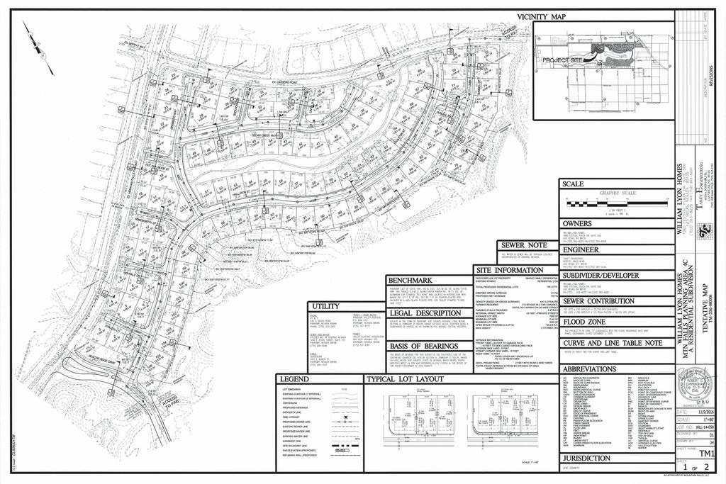
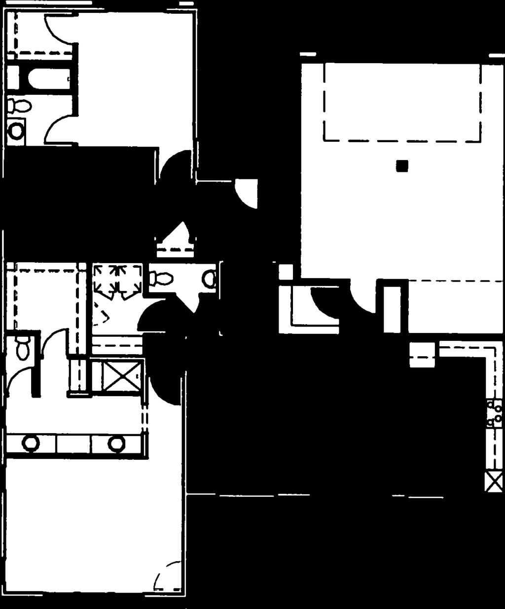
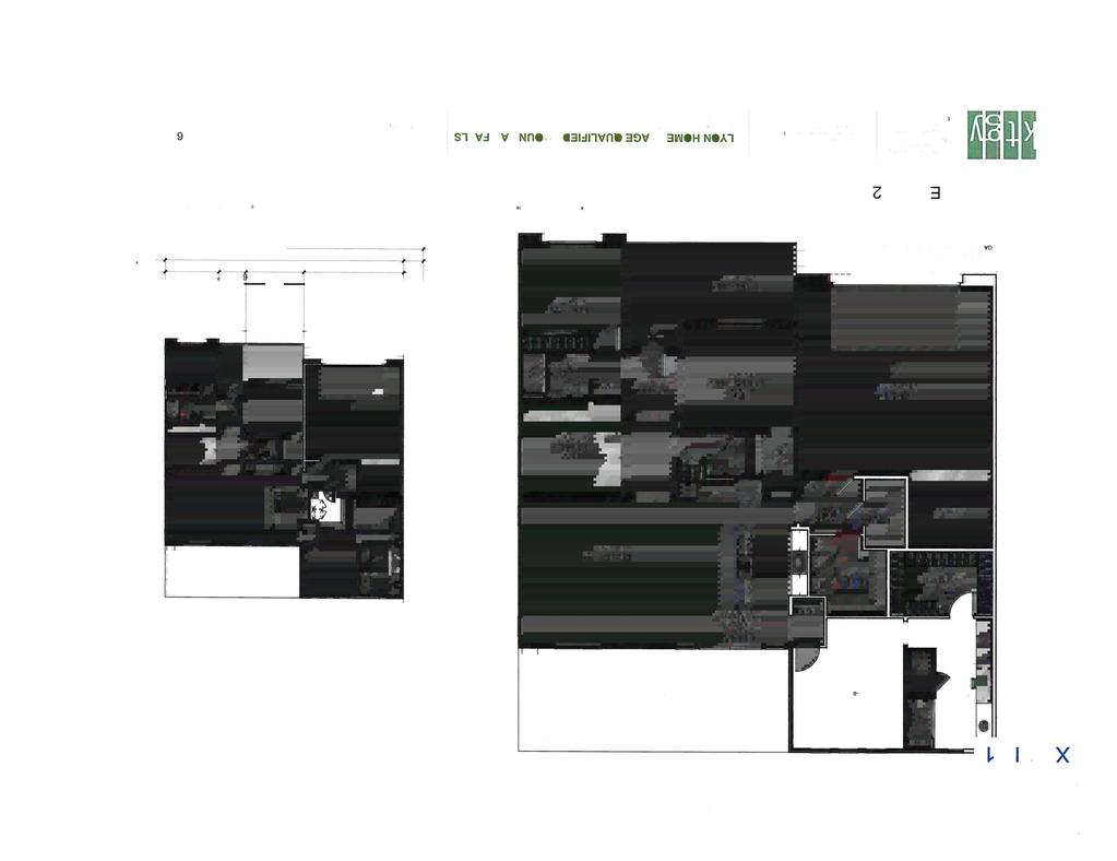
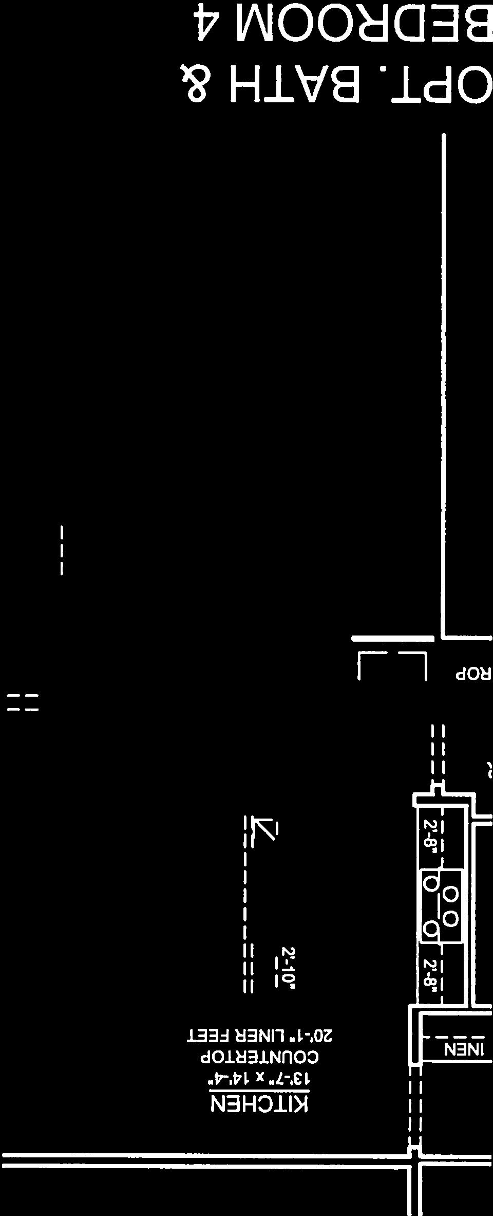
1 CASE DESCRIPTION(S): LOCATION: APN NUMBER(S): AP# NYE COUNTY, NV PAHRUMP REGIONAL PLANNING COMMISSION REGULAR MEETING JANUARY 11, 2017 a. For Possible Action TM : Tentative Map application for a subdivision containing 106 residential lots on approximately acres, located within the Mountain Falls Master Planned Community. b. For Possible Action Waivers from Design Standards: 1. Waiver from the street design standards to allow for a 28-foot private street section where 29-ft. is the standard. 2. Waiver from the subdivision street entry design standards to allow for a 51-foot private street standard where 59-ft. is the standard. 3. Waiver from the front Residential low setback design standard to allow for a 10-foot front building setback where 15-ft is the minimum. 4. Waiver from the rear Residential low setback design standard to allow for a 10-foot rear building setback where 15-ft is the minimum. (CB) Mountain Falls master planned community, located just west of Fontana Street and south of the northern Parkway Planning. AKA: Planning Area 4C LEGAL DESCRIPTION(S): Parcel 4C per File Map # Staff Report Agenda Items No. 8 PROPERTY OWNER(S): APPLICANT(S): AGENT(S): Mountain Falls LLC Mountain Falls LLC Taney Engineering STAFF CONTACT: Cheryl Beeman, AICP & Principal Planner (775) PROJECT SYNOPSIS: The applicant is requesting approval of a Tentative Subdivision Map for one-hundred three (106) residential lots and 20 common element lots on the approximately acre site for an overall density of 4.9 du/ac within this Planning Area. The subject property is located within the Mountain Falls Master Planned Community, and subject to a Development Agreement between Nye County and Mountain Falls Acquisition Corp., that is valid and in effect until December 31, This subdivision is being marketed as a gated and age-qualified community with a proposed resident s facility (facility to be located within Planning Area 6). Figure 1: Planning Area 4C APN
2 Pahrump Regional Planning Commission Staff Report; TM January 11, 2017 Page 2 of 10 The following waivers from design standards have been requested; 1. Waiver from the street design standards to allow for a 28-foot private street section where 29-ft. is the standard (document ). 2. Waiver from the subdivision street entry design standards to allow for a 29-foot private street standard where 59-ft. is the standard (document ). 3. Waiver from the front Residential low setback design standard to allow for a 10-foot front building setback where 15-ft is the minimum, (document ). 4. Waiver from the rear Residential low setback design standard to allow for a 10-foot rear building setback where 15- ft is the minimum, (document ). Pursuant to NCC , the Board has delegated authority to the RPC to take final action on Tentative Subdivision Maps. This action requires a simple majority vote of the members present to pass a motion. Conclusions The proposed Tentative Subdivision is in conformance with Nye County Code, and the minimum requirements outlined in Nevada Revised Statutes (NRS) The RPC may, condition their approval to ensure that the tentative map is in conformance with the Development Agreement, County and State standards prior to submittal of the Final map.. RECOMMENDED MOTION(S): Move to (Options include approve, conditionally approve, continue, or deny) TM , and the Waivers from Design Standards based upon the findings as outlined below and subject to the conditions as stipulated within this report or as based upon additional conditions and/or alternate findings as established by the Pahrump Regional Planning Commission. Applicable NRS Sections: 1. NRS , (Tentative map to be forwarded to school board; acquisition or disposal of school site) outlines and governs the mechanisms involved in the acquisition of school sites. The NRS does not make a distinction between a commercial/industrial subdivision and a residential subdivision for purposes of a school site. 2. NRS , (Application for matter relating to land use planning required to be complete for acceptance by governing body; review for completeness; procedure for return of incomplete application), outlines the timeframe for declaring an application incomplete. 3. NRS Section ; (Action on tentative map by governing body; considerations in determining action on tentative map; final disposition) provides for the timeframe that the Planning Commission has to take action on a tentative map (60-days from the date that the application has been deemed complete), and outlines the matters that shall be considered by a planning commission that is authorized to take action on a tentative map and are as follows: (a) Environmental and health laws and regulations concerning water and air pollution, the disposal of solid waste, facilities to supply water, community or public sewage disposal and, where applicable, individual systems for sewage disposal; Environmental and health laws and regulations will be adhered to and facilities for the disposal of solid waste, supply water and provide public sewage disposal will be installed and managed by Great Basin Water Co. (formerly known as; Utilities Inc. of Central Nevada). (b) The availability of water which meets applicable health standards and is sufficient in quantity for the reasonably foreseeable needs of the subdivision; Applicant has provided that no additional water rights are being required by Great Basin Water Co., that sufficient water-rights have been deeded to the utility company to provide service for this property.
3 Pahrump Regional Planning Commission Staff Report; TM January 11, 2017 Page 3 of 10 (c) The availability and accessibility of utilities; Public utilities are available and will be installed and maintained under the Great Basin Water Co. (formerly known as; Utilities Inc. of Central Nevada) (d) The availability and accessibility of public services such as schools, police protection, transportation, recreation and parks; Impact Fee Ordinance #302 adopted August 17, 2005 established Fire, Park, Police and Street impact fees, Nye County Resolution No was adopted August 23, 2004 which imposed a tax on new residential construction to finance schools. May 9, 2011 WLH filed a lawsuit against the County to adjudicate WLH claims of exemption from the impact fees and school tax. The Settlement Agreement between WLH, Mountain Falls LLC and Nye County stipulates that the lands under the Development Agreement (Amended and Restated as Doc. # ), shall remain subject to the school tax, the fire station impact fee, the police impact fee and shall be exempt from the park impact fee and street impact fee. Therefore, the availability and accessibility of public services outside of the master planned community may be considered diminished with respect to transportation, public parks and recreation, (example: Homestead Rd. between Manse and Gamebird). (e) Conformity with the zoning ordinances and master plan, except that if any existing zoning ordinance is inconsistent with the master plan, the zoning ordinance takes precedence; The proposed map is consistent with the 2014 Master Plan Update and with the Mountain Falls Development Agreement land use plan which designates the subject parcel as Residential Low, allowing for a density of up to 8 units per acre. The tentative map is about 4.7 units per acre are planned. (f) General conformity with the governing body s master plan of streets and highways; The proposal is in conformance with the streets and highways plan of the Adequate Public Facilities Plan (g) The effect of the proposed subdivision on existing public streets and the need for new streets or highways to serve the subdivision; The Settlement Agreement between WLH, Mountain Falls LLC and Nye County stipulates that the lands under the Development Agreement (Amended and Restated as Doc. # ), shall be exempt from the street impact fee. Streets within Planning Area 4C are planned as 43-ft. wide private streets, providing an 8-ft. parking lane on each side, a 4-ft. sidewalk and two 10-ft. wide travel lanes (17-ft. travel lane if no vehicles are parking in the street). The 28-ft. wide private street section provides for no on street parking, no sidewalk and two ft. travel lanes. Neither of these street sections are markedly different than those approved in document # (Amendment # 1). Main access for Planning Area 4C is from Mountain Falls Parkway. All internal streets are planned as private streets, and will not be dedicated to Nye County for future ownership or maintenance. 43 Ft. and 28 Ft. Street Cross Sections per this Planning Area provided below.
4 Pahrump Regional Planning Commission Staff Report; TM January 11, 2017 Page 4 of 10 Figure 2: Proposed 43-ft. Private Street Cross Section Figure 3: Proposed 28-ft. Private Street Cross Section w/out Parking or Sidewalks, (Drive Lane width is 11.5 feet more or less)
5 Pahrump Regional Planning Commission Staff Report; TM January 11, 2017 Page 5 of 10 Figure 4: 20-Ft. Street Section per Document # Amendment No. 1 to the Mtn. Falls DA (h) Physical characteristics of the land such as floodplain, slope and soil; The planning areas within Mountain Falls master planned community have been engineered out of the FEMA mapped special flood hazard area (SFHA), site exhibits minimal slopes. (i) The recommendations and comments of those entities and persons reviewing the tentative map pursuant to NRS to , inclusive; Nevada Division of Environmental Protection recommends approval of the subdivision with respect to water pollution and sewage disposal, and based upon a commitment from Utilities Inc.. of Central Nevada to provide sewage service to the subdivision. (j) The availability and accessibility of fire protection, including, but not limited to, the availability and accessibility of water and services for the prevention and containment of fires, including fires in wild lands; and Fire hydrant locations are noted in the map. Pahrump Fire and Rescue Services have provided comments under External Comments. Staff from these departments have expressed concern regarding the 28-ft. street standards and the responsibility to enforce no parking on the private streets, noting that the County will not be the enforcement agency. (k) The submission by the subdivider of an affidavit stating that the subdivider will make provision for payment of the tax imposed by chapter 375 of NRS and for compliance with the disclosure and recording requirements of subsection 5 of NRS , if applicable, by the subdivider or any successor in interest.
6 Pahrump Regional Planning Commission Staff Report; TM January 11, 2017 Page 6 of 10 According to the Nye County Treasurer s Office only the 1 st & 2 nd quarters of have been paid. Payment in full is required prior to recording a final map. ANALYSIS Background: The property has an extensive background, the table below describes the Development Agreements, Amendments and Settlement Agreements and does not cover the extensive parcel mapping, merger & resubdivisions, tentative or final subdivision mapping. Date Document # Description 10/18/ EA Collins purchases lands in Pahrump 11/30/ Mountain Falls Phase 1 Final Map recorded 12/5/ Adoption of a Development Agreement with E.A. Collins Development Corporation for the Mountain Falls Common Interest Community 07/12/ Commercial Federal files a lawsuit for bankruptcy against EA Collins 06/17/ Commercial Federal sells Mt. Falls holdings to Mountain Falls Acquisition Corp. 04/25/ A Settlement Agreement and Mutual Release 11/17/ Amended and Restated Development Agreement Revised Mountain Falls Development Agreement 06/30/ Assignment and Assumption of Agreement between Mountain Falls Acquisition Corp., WLH, Inc. and Mountain Falls Golf Course, LLC. 09/21/ Mountain Falls Revised Development Agreement Amendment # 1 09/21/ Settlement Agreement between WLH, MF LLC and Nye County Area Characteristics: The subject property is located within a Master Planned Golf Course Community, and is within flood zone X (unshaded), which corresponds to areas outside the 500-year flood hazard area as indicated by the Flood Insurance Rate Map (FIRM). Applicant is requesting approval of a Tentative Residential Subdivision Map for 106 residential lots. The area to be subdivided does not match the current parcel configuration. The tentative map shows the old boundary vs. the proposed new boundary. Adjusting the parcel boundary will require a separate mapping action and the applicants request that the RPC condition approval on this (see Condition of Approval # 23). A Parcel Map to remap the boundaries of the Golf Course, Planning Area 4C, 6 & 7 has been submitted for review on 12/15/2016. Planning Area 4C is located along Mountain Falls Parkway and is bordered by E. Cassero Road on the east. Access is from the Parkway. The proposed subdivision design shows a meandering road with 1 planned access point to the Parkway. The subdivision design provides one long 43-ft. road that terminates in a hammer-head design. Several stubstreets are proposed for use. In most cases the stub street provided access to 6 SFR lots, and in one case provides access to 8 SFR lots. A large expanse of useable open space is provided (93,262 sq. ft. situated in the middle of the subdivision. Map shows a meandering sidewalk through this common element lot. Traffic count for 106 age qualified residential units is estimated at 4 trips /dwelling unit (Senior housing) or about 424 average daily trips. The plan indicates an average lot size of 60 X 110 or 6,600 sq. ft., a minimum lot size of 60 X 102 or 6,120 sq. ft., and the maximum lot size of 12,262 sq. ft. The smallest residential lot in the subdivision is 5,630 sq. ft. staff notes that the typical or average lot size appears to be 6,180 sq. ft. rather than 6,600 sq. ft. External Comments: Nye County School District: There may be some interest in re-visiting the school site pursuant to NRS (see page 2 of this report Applicable NRS Sections). Public Works comments: Public Works supports and facts, findings or conditions determined by the PRPC at this time, reserving the right to provide additional facts, findings and conditions upon the submission of the improvement
7 Pahrump Regional Planning Commission Staff Report; TM January 11, 2017 Page 7 of 10 plans for any commercial/industrial development of the property and/or complying with Nye County Code. 1. All improvements are to be built to Nye County Public works Guidelines for Design and Review of Development Engineering Submission and Nye County standards. 2. On-street parking along the 28 wide private ROW will not be supported by PW. 3. All streets are to remain private. 4. All streets are to be a minimum of 31/2 of AC over 10 of Type II Base. 5. Cross-slope of the street section shall be no less than 2.5% and no greater than 5%. 6. Site information needs to be changed to indicate private streets. Town of Pahrump Fire Department: No parking on the streets will need to be enforced. Turn around areas for larger apparatus is a concern as is hydrant access. Place an additional hydrant on the T street section. Nye County Emergency Services: in high density housing, the major concerns are turn radii for ladder trucks, hydrants every 300' instead of 500', a parking plan that can be enforced (to prevent access problems), setbacks and side clearances to minimize flame spread from structure to structure, sidewalk and driveway standards that support movement of EMS, possibility of required residential sprinklers, rain run-off diversion designed to not create high speed currents known to grab kids and pets, enforceable landscaping plans that aid law enforcement in daily surveillance, and utilities designed for easy access during emergencies. Pahrump Town Manager: No comments received Nevada Division of Environmental Protection: Recommends approval of said subdivision with respect to water pollution and sewage disposal, provided that Utilities Inc. of Central Nevada (UICN) commits to provide sewage service to said subdivision. The developer is advised that final map approval is contingent upon NDEP approval of Improvement Plans for water and sewer. Public Utilities Commission of Nevada: (Two different responses received) 1. Engineering Dept.: The PUCN is involved in Subdivision Reviews of Tentative Mapping when the utility provider is subject to the provisions of NRS and is under our jurisdiction (Utilities Inc. of Central NV). The applicable statutes are under NRS and NRS Once you file, Staff will conduct an investigation to determine the adequacy of water and sewer supply for the subdivision. The Applicant will file for a Subdivision Clearance (see the following link for the associated fee), and Staff will be in contact with specific questions and requests for information. 2. Legal Dept.: Pursuant to NRS (3), the Regulatory Operations Staff of the Commission believes the Commission does not need to review the Mountain Falls Tentative Map since the utility furnishing the water supply or sewer service already has a certificate of public convenience and necessity granted by the Commission to serve the area set forth in the tentative map. Please be advised that the Regulatory Operations Staff does not have the authority to speak for the Commission. Applicable NCC Sections: NCC Design Standards; Generally F. Residential Subdivision Design: 1. In conventional subdivisions, the planning commission may vary lot areas and dimensions, yards, and setbacks for the purpose of encouraging and promoting flexibility, economy, and environmental soundness in layout and design, provided that the average lots' areas and dimensions, yards, and setbacks within the development conform to the minimum requirements of this chapter, and provided that such standards shall be appropriate to the type of development permitted.
8 Pahrump Regional Planning Commission Staff Report; TM January 11, 2017 Page 8 of Residential lots shall front on residential access or residential subcollector streets, not on collector or arterial streets, highways or other higher order streets. 3. Every lot shall have sufficient access to it for emergency vehicles as well as for those needing access to the property in its intended use. 4. The placement of units in residential developments shall take into consideration topography, privacy, building height, orientation, drainage, and aesthetics. NCC 15.24: Street Naming and Property Numbering within the PRPD I. Requirements for Private Streets: 1. All private streets which provide the only means of access to a minimum of three (3) properties or buildings shall be named and signage shall be provided in accordance with this chapter. 2. A sign, bearing the words "Private Street" may be mounted directly below the street name sign by the street owner(s). 3. All private street signage and hardware, as well as the expense for the material, shall be the responsibility of the landowner and shall conform to the design standards in effect at the time of installation. CONCLUSIONS It is staff s opinion that sufficient review of this application has been provided and the RPC may choose to condition their approval on any outstanding matters. The proposed Tentative Subdivision appears to be in substantial conformance with Nye County Code, but there are discrepancies with the Mountain Falls Development Agreement. The RPC may if they choose to do so, condition their approval so that the tentative map shall be in conformance with all standards prior to submittal of the Final map. The following CONDITIONS FOR APPROVAL are suggested and are subject to the discretion of the Regional Planning Commission: Tentative Map Standard Conditions of Approval 1. Form of the Final Map shall comply with all applicable state and local statutes, ordinances, codes, rules and regulations in effect at the time of recordation as well as compliance with plans, documents, reports, etc. submitted by the Developer(s). 2. Developer(s) shall, at their own cost, perform and complete all work and improvements required under the Development Agreement, state and county statutes, codes, regulations, etc. 3. No construction of public improvements shall occur until construction plans are submitted and approved in accordance with the Document Submittal Requirements along with the calculations of the construction valuation, and plans check and inspection fees shall be borne by the Developer(s). 4. Prior to submittal of the Final Map, a preliminary title report not more than ninety (90) days old must be provided. Should the title report reference additional holders(s) of security interest, written consent of each holder or record of a security interest must be provided by signing the map or by signing a separate document that shall be recorded along with the final subdivision map. If a separate document is recorded with the map, the map must contain notation to that fact. 5. At the time of final map approval, all taxes for the current fiscal year shall be paid in full. (The Treasurer s signature will be obtained by the Planning Department). 6. Final monuments must be set by a professional land surveyor licensed in the State of Nevada before recordation of the final map. In lieu of setting monuments the Surveyor may furnish a performance bond or other suitable assurance to the governing body that will guarantee that the Surveyor will set the monuments on or before a date certain. Please note that the Surveyor s Statement indicates that the monuments depicted will occupy the position.
9 Pahrump Regional Planning Commission Staff Report; TM January 11, 2017 Page 9 of The form of the Final Map shall conform to the requirements outlined within N.R.S and the Document Submittal Requirements for Division of Land Applications within the PRPD. 8. Public utility rights-of-ways and easements must be approved by the utilities in whose favor the rights-of-way are being granted by signature of each utility s authorized representative appearing on the map. 9. All utilities servicing the development shall be provided underground except for main lines entering the subdivision along the perimeter. Utility easements shall be provided ten (10) feet each side of the centerline of all existing pole lines; and a ten (10) foot public utility easement shall be provided along the perimeter of all properties within the boundary of the final map. 10. The Final Map will not be approved until the engineered improvement plans for grading, streets, and utilities, the drainage study, the traffic study and/or traffic impact assessments have been reviewed and approved by the Nye County Public Works Department. These studies will be used to determine on-site improvements and assess developer for all off tract mitigation per NCC. 11. Off-Tract Assessments fees, bonding, and improvement agreements must be in place prior to Final Map approval. 12. All road obstructions and encumbrances shall be removed from the public Right-of-Way. 13. Should the developer submit the Final map in phases, legal, physical and EMS approved access shall be provided to any remnant parcel(s). 14. In such cases where double frontage lots are unavoidable, restrictions shall be implemented to restrict main residential access/addressing to one street. 15. The applicant shall pay for the cost and installation of street name signs in accordance with Manual on Uniform Traffic Control Devices for Streets and Highways (MUTCD) standards and Nye County Public Works Department standards. This cost includes the placement and/or replacement of street name signs at all street intersections affected by this approval. a. Design and placement of traffic signs shall be in accordance with the Nye County Standard Details and Specifications for Public Improvements within the Pahrump Regional Planning District. b. Design and location of street signs shall be shown on the engineer s plans for street improvements and shall be installed prior to final inspection of the roadway. c. At least one (1) street sign shall be placed at each four-way street intersection, and one at each T intersection. Signs shall be installed free of visual obstruction, and shall be installed under light standards where light standards exist. The design of street name signs shall be in accordance with the standards found in the document entitled Standard Details and Specifications for Public Improvements within the Pahrump Regional Planning District. 16. Driveway aprons shall extend from the edge of pavement within the street ROW to the private property and shall conform to the Standard Details and Specifications for Public Improvements Within the Pahrump Regional Planning District and includes: a. Developer shall maintain the drainage swales and shall not obstruct flows adjacent to the subject property. b. The type of ownership of land dedicated for open space purposes shall be defined by a note on the map and shall be subject to approval by the Board of County Commissioners at the time of Final Map review. c. Conformance with the adopted DA and applicable Nye County Standards regarding street ROWs and street improvements. d. Developer(s) shall participate and perform and complete all work (at their own expense related to on-site improvements) required by the Development Agreement and applicable state and county statutes, codes, and regulations. 17. Developer shall dedicate to County up to the full width of half the right of way of any streets and highway on their side of the property if such right of way is required by the Master Plan and/or County Capital Improvement Plan;
10 Pahrump Regional Planning Commission Staff Report; TM January 11, 2017 Page 10 of All future development shall follow Mountain Falls Development Agreement design standards and Nye County standards as applicable or as amended pursuant to Section of the Development Agreement. 19. The need for traffic improvements required as a result of a Traffic Impact Analysis (TIA) shall be reviewed and compared for compliance w/the Master Mtn. Falls revised Transportation Plan. 20. Geotechnical Reports and Technical Drainage Studies when required and must receive Public Department approval prior to submitting any improvement plans for review. Tentative Map Special Conditions of Approval 21. Approval of this tentative map, shall be for a period of four years from the effective date of approval. 22. Applicant shall file and have reviewed, approved and recorded a parcel map that will rectify the boundary between Planning Area 4C (APN: ) and the golf course parcel (APN: ) prior to approval of the final map. The purpose of the map is to rectify the boundary between the golf course and the individual residential lots proposed by this tentative map (TM ). 23. Applicant shall resolve all tentative map concerns per Public Works requirements, Planning Department requirements and Co. Assessor s requirements prior to submitting a Final Map. 24. All open spaces, landscaped areas along or within the ROWs as noted on the Tentative Map shall be installed, irrigated and maintained by the developer or a property owner s association. 25. Lots within the subdivision map shall be renumbered using Block numbers as well as lot numbers. 26. Streets shall be privately owned and maintained. 27. All utility boxes and vaults must be installed within the utility easement and not in Nye County Right-of-Way. 28. Applicant shall submit plans for review and approval before installing any gate, or any other fire apparatus access roadway obstructions. 29. Applicant shall submit fire apparatus access road (fire lane) plans for Fire Department review and approval, including primary and secondary roads from the proposed project to existing paved roadways during construction until such access routes are permanently developed. 30. Prior to approval of the Final Map the Developer will provide an updated Master Plan to show how the 3,200 dwelling units are being distributed throughout the planned community. 31. Street signs shall be installed prior to issuance of building permits.
11
12


13
14
15
16


17


18


19


20


21


22


23


24


25


26


27


28


29


30


31
32
33


34
35
36
NYE COUNTY, NV PAHRUMP REGIONAL PLANNING COMMISSION REGULAR MEETING DECEMBER 14, 2016
 CASE DESCRIPTION(S): LOCATION: APN NUMBER(S): AP# 045-021-21 LEGAL DESCRIPTION(S): PROPERTY OWNER(S): APPLICANT(S): AGENT(S): NYE COUNTY, NV PAHRUMP REGIONAL PLANNING COMMISSION REGULAR MEETING DECEMBER
NYE COUNTY, NV PAHRUMP REGIONAL PLANNING COMMISSION REGULAR MEETING JUNE 14, 2017
 NYE COUNTY, NV PAHRUMP REGIONAL PLANNING COMMISSION REGULAR MEETING JUNE 14, 2017 Staff Report Agenda Item No. 11 CASE DESCRIPTION(S): LOCATION: APN NUMBER(S): 039-585-14 For Possible Action WV-2017-000047:
Parcel Map Review Committee Staff Report
 Parcel Map Review Committee Staff Report Meeting Date: October 11, 2018 Agenda Item: 7A TENTATIVE PARCEL MAP CASE NUMBER: (Larkins) BRIEF SUMMARY OF REQUEST: Request to divide one parcel of ±1.084-acres
LYON COUNTY COMMUNITY DEVELOPMENT DEPARTMENT
 LYON COUNTY COMMUNITY DEVELOPMENT DEPARTMENT B UILDING D EVELOPMENT E NGINEERING P LANNING 27 S. MAIN S TREET Y ERINGTON, NEVADA 89447 (775) 463-6591 F AX: (775) 463-5305 34 LAKES B OULEVARD D AYTON, NEVADA
Parcel Map Review Committee Staff Report Meeting Date: March 12, 2015
 Subject: Applicant(s): Agenda Item Number: Parcel Map Review Committee Staff Report Meeting Date: March 12, 2015 Parcel Map Case Number William and Maryanne Paganetti 7B Project Summary: Dividing a 14.2
NYE COUNTY, NV PAHRUMP REGIONAL PLANNING COMMISSION REGULAR MEETING APRIL 15, 2015
 NYE COUNTY, NV PAHRUMP REGIONAL PLANNING COMMISSION REGULAR MEETING APRIL 15, 2015 Staff Report Agenda Item No. 10 CASE DESCRIPTION(S): For possible action CU-2015-000005: Public hearing, discussion, deliberation
NYE COUNTY, NV PAHRUMP REGIONAL PLANNING COMMISSION REGULAR MEETING May 10, 2017
 NYE COUNTY, NV PAHRUMP REGIONAL PLANNING COMMISSION REGULAR MEETING May 10, 2017 Staff Report Agenda Item No. 12 CASE DESCRIPTION(S): For Possible Action WV-2017-000042: Public hearing, discussion, deliberation
NYE COUNTY, NV PAHRUMP REGIONAL PLANNING COMMISSION REGULAR MEETING OCTOBER 12, 2016
 NYE COUNTY, NV PAHRUMP REGIONAL PLANNING COMMISSION REGULAR MEETING OCTOBER 12, 2016 Staff Report Agenda Item No. 10 CASE DESCRIPTION(S): For possible action ZC-2016-000009: Public hearing, discussion,
CHAPTER 22 SUBDIVISION AND LAND DEVELOPMENT
 CHAPTER 22 SUBDIVISION AND LAND DEVELOPMENT 22-101. Title 22-102. Legislative Intent Part 1 General Provisions 22-201. Development Permits Part 2 Administration 22-301. Fee Schedule Part 3 Fee Schedule
Parcel Map Review Committee Staff Report Meeting Date: October 13, 2016
 Subject: Applicant: Agenda Item Number: Project Summary: Recommendation: Parcel Map Review Committee Staff Report Meeting Date: October 13, 2016 Parcel Map Case Number Spanish Springs Associates Ltd. Ptsp.
-MENDOCINO COUNTY PLANNING AND BUILDING SERVICES- DIVISION OF LAND REGULATIONS TITLE 17
 ARTICLE VI -- GENERAL REGULATIONS AND PROVISIONS Sec. 17-50. Sec. 17-51 General Plan. Sec. 17-52 Lot and Block Design and Configuration. Sec. 17-53 Lot Access. Sec. 17-54 Private Roads. Sec. 17-55 Water
NYE COUNTY, NV PAHRUMP REGIONAL PLANNING COMMISSION REGULAR MEETING December 14, 2016
 NYE COUNTY, NV PAHRUMP REGIONAL PLANNING COMMISSION REGULAR MEETING December 14, 2016 Staff Report Agenda Item No. 13 CASE DESCRIPTION(S): LOCATION: For Possible Action CU-2016-000023: Public hearing,
NYE COUNTY, NV PAHRUMP REGIONAL PLANNING COMMISSION MEETING JANUARY 11, 2017
 NYE COUNTY, NV PAHRUMP REGIONAL PLANNING COMMISSION MEETING JANUARY 11, 2017 Staff Report Agenda Item No. 13 CASE DESCRIPTION(S): For Possible Action CU-2016-000029: Public hearing, discussion, deliberation
Parcel Map Review Committee Staff Report Meeting Date: October 8, 2015
 Parcel Map Review Committee Staff Report Meeting Date: October 8, 2015 Subject: Applicant: Agenda Item Number: Project Summary: Recommendation: Parcel Map Case Number Reeves Business Ventures 7D Divide
Preliminary Subdivision Application (Minor) (Three (3) lots or less)
 (Three (3) lots or less)") Gunnison City Offices www.gunnisoncity.org 38 West Center Gunnison, Utah 84634 (435) 528 7969 Date of Application: Preliminary Subdivision Application (Minor) (Three (3) lots or less) APPLICANT INFORMATION
Gunnison City Offices www.gunnisoncity.org 38 West Center Gunnison, Utah 84634 (435) 528 7969 Date of Application: Preliminary Subdivision Application (Minor) (Three (3) lots or less) APPLICANT INFORMATION
Parcel Map Review Committee Staff Report Meeting Date: May 12, 2016
 Subject: Applicant: Agenda Item Number: Project Summary: Recommendation: Parcel Map Review Committee Staff Report Meeting Date: May 12, 2016 Tentative Parcel Map Case Number TL Mt. Rose Estates, LP 7C
UPPER MOUNT BETHEL TOWNSHIP NORTHAMPTON COUNTY, PENNSYLVANIA
 UPPER MOUNT BETHEL TOWNSHIP NORTHAMPTON COUNTY, PENNSYLVANIA JOINDER DEED / LOT CONSOLIDATION TOWNSHIP REVIEW PROCESS When accepting proposed Joinder Deeds / Lot Consolidations, review the Joinder Deed
STAFF REPORT # CONDITIONAL USE PLANNING COMMISSION MEETING DATE: July 20, 2017
 STAFF REPORT #17-4000-0005 CONDITIONAL USE PLANNING COMMISSION MEETING DATE: July 20, 2017 1. APPLICATION: An application submitted by Stephanie Moye requesting a conditional use permit to allow for a
CITY OF GROVER BEACH COMMUNITY DEVELOPMENT DEPARTMENT Tentative Map Checklist
 CITY OF GROVER BEACH COMMUNITY DEVELOPMENT DEPARTMENT Tentative Map Checklist The following list includes all of the items you must submit for a complete application. Some specific types of information
SUBDIVISION DESIGN PRINCIPLES AND STANDARDS
 SECTION 15-200 SUBDIVISION DESIGN PRINCIPLES AND STANDARDS 15-201 STREET DESIGN PRINCIPLES 15-201.01 Streets shall generally conform to the collector and major street plan adopted by the Planning Commission
NYE COUNTY, NV PAHRUMP REGIONAL PLANNING COMMISSION REGULAR MEETING DECEMBER 14, 2016
 NYE COUNTY, NV PAHRUMP REGIONAL PLANNING COMMISSION REGULAR MEETING DECEMBER 14, 2016 Staff Report Agenda Item No. 14 CASE DESCRIPTION(S): LOCATION: For possible action ZC-2016-000011: Public hearing,
Preliminary Subdivision Application (Major) (Four (4) lots or more)
 (Four (4) lots or more)") Gunnison City Offices www.gunnisoncity.org 38 West Center Gunnison, Utah 84634 (435) 528 7969 Date of Application: Preliminary Subdivision Application (Major) (Four (4) lots or more) APPLICANT INFORMATION
Gunnison City Offices www.gunnisoncity.org 38 West Center Gunnison, Utah 84634 (435) 528 7969 Date of Application: Preliminary Subdivision Application (Major) (Four (4) lots or more) APPLICANT INFORMATION
a. provide for the continuation of collector streets and thoroughfare streets between adjacent subdivisions;
 Section 7.07. Intent The requirements of this Section are intended to provide for the orderly growth of the Town of Holly Springs and its extra-territorial jurisdiction by establishing guidelines for:
COMMERCIAL SITE PLAN & CONDITIONAL USE PERMIT REVIEW PROCESS & CHECKLIST
 Community Development 110 South Main Street Springville, UT 84663 COMMERCIAL SITE PLAN & CONDITIONAL USE PERMIT REVIEW PROCESS & CHECKLIST 801.491.7861 www.springville.org Prior to the issuance of a building
The purpose of this Chapter is to establish rules, regulations, standards and procedures for approval of subdivisions of land to promote and ensure:
 CHAPTER 7 SUBDIVISION SECTION 7.1 PURPOSE The purpose of this Chapter is to establish rules, regulations, standards and procedures for approval of subdivisions of land to promote and ensure: A. Conformity
Guide to Preliminary Plans
 Guide to Preliminary Plans Introduction The Douglas County is committed to providing open, transparent application processes to the public. This Guide is provided to assist anyone interested in the procedures
NYE COUNTY, NV PAHRUMP REGIONAL PLANNING COMMISSION MEETING October 12, 2016
 NYE COUNTY, NV PAHRUMP REGIONAL PLANNING COMMISSION MEETING October 12, 2016 Staff Report Agenda Item No. 12 CASE DESCRIPTION(S): a. For Possible Action CU-2016-000015: Public hearing, discussion, deliberation
SUBDIVISION APPLICATION CHECKLIST SKETCH PLAN PRELIMINARY PLAT FINAL PLAT
 RECEIVED STAMP SUBDIVISION APPLICATION CHECKLIST SKETCH PLAN PRELIMINARY PLAT FINAL PLAT A checklist of background information and submission requirements for processing of a sketch plan, preliminary plat
MAJOR SUBDIVISION APPLICATION
 Revised 2.26.18 The Department is here to assist you with your development application pursuant to the Community Development Code (CDC). This publication outlines the Major Subdivision Development Application
MIDWAY CITY Planning Office 75 North 100 West Phone: x105 Midway, Utah Fax:
 MIDWAY CITY Planning Office 75 North 100 West Phone: 435-654-3223 x105 Midway, Utah 84049 Fax: 435-654-2830 mhenke@midwaycityut.org Preliminary/ Final Application for Small Scale Subdivision Application
TENTATIVE PARCEL MAP TIME EXTENSION
 EL DORADO COUNTY DEVELOPMENT SERVICES ZONING ADMINISTRATOR STAFF REPORT Agenda of: October 15, 2008 Item No.: Staff: 4.a. Mel Pabalinas TENTATIVE PARCEL MAP TIME EXTENSION APPLICATION FILE NO.: APPLICANT:
Parcel Map Review Committee Staff Report Meeting Date: March 12, 2015
 Parcel Map Review Committee Staff Report Meeting Date: March 12, 2015 Subject: Applicant(s): Agenda Item Number: Project Summary: Recommendation: Prepared by: Parcel Map Case Number Eric and Rebecca Swanson
Note to the Owner, Applicant & Agent:
 Note to the Owner, Applicant & Agent: The Nye County Planning Department does not accept incomplete Zoning Review Applications. Please see highlighted requirements below PRIOR to submitting. The Zoning
COUNTY OF EL DORADO DEVELOPMENT SERVICES PLANNING COMMISSION STAFF REPORT TENTATIVE MAP
 COUNTY OF EL DORADO DEVELOPMENT SERVICES PLANNING COMMISSION STAFF REPORT Agenda of: June 27, 2013 Item No.: 9.a Staff: Mel Pabalinas TENTATIVE MAP FILE NUMBER: APPLICANT: REQUEST: LOCATION: TM10-1501/West
BRIDGETON SUBDIVISION APPLICATION CHECKLIST
 APPLICATION NAME AND # CHECKLIST COMPLETED BY: DATE: Signature and printed name BRIDGETON SUBDIVISION APPLICATION CHECKLIST TO SUBDIVISION APPLICANTS: The attached checklist is to assist you in the submission
Memorandum: October 13, 2008 REVISED To: Trowbridge Township Planning Commission From: P. Hudson, AICP Re: Suggested New Ordinance
 1 Memorandum: October 13, 2008 REVISED 2-11-09 To: Trowbridge Township Planning Commission From: P. Hudson, AICP Re: Suggested New Ordinance Because of changes in both the Michigan Planning Enabling Act
City of Leavenworth DEPARTMENT OF DEVELOPMENT SERVICES MAJOR SUBDIVISION APPLICATION 1
 Proposed Name of Subdivision: City of Leavenworth DEPARTMENT OF DEVELOPMENT SERVICES MAJOR SUBDIVISION APPLICATION 1 FOR PRELIMINARY SUBDIVISION APPROVAL This application must be filled out legibly, in
Cover Letter with Narrative Statement
 Cover Letter with Narrative Statement March 31, 2017 rev July 27, 2017 RE: Rushton Pointe Residential Planned Unit Development Application for Public Hearing for RPUD Rezone PL2015 000 0306 Mr. Eric Johnson,
Initial Subdivision Applications Shall Include the Following:
 Initial Subdivision Applications Shall Include the Following: 1) Subdivision Application Form: completely filled out (12 copies) 2) Plat: The Plat must adhere to the requirements set forth in the Town
Town of Lisbon, Maine SUBDIVISION REVIEW APPLICATION
 Date Received: Fee Paid (amount): Applicant: Town of Lisbon, Maine SUBDIVISION REVIEW APPLICATION Subdivision Name/Title: This application must be received at the Town Office by close of business on the
A. Appropriate agency responsible for transportation review for the subject property.
 7.8.10 Procedure Any person desiring to create a minor subdivision shall submit to the Commission for approval an application on forms provided by the Division, and a record plat in conformance with the
I. Requirements for All Applications. C D W
 108-16.1. Application checklists. Checklist for Required Submissions to the Planning Board or Zoning Board of Adjustment of Monroe Township All required submissions are to be made to the Administrative
Guide to Combined Preliminary and Final Plats
 Guide to Combined Preliminary and Final Plats Introduction The Douglas County is committed to providing open, transparent application processes to the public. This Guide is provided to assist anyone interested
WHEREAS, the staff of The Maryland-National Capital Park and Planning Commission recommended APPROVAL of the application with conditions; and
 R E S O L U T I O N WHEREAS, Redeemed Christian Church of God is the owner of a 2.83-acre parcel of land known as Lot 9, Lot 19, P/O Lot 1 and P/O Lot 18, Block B, Plat Book A, Plat 5, said property being
Project File #: SF Project Name: Jackson Ranch Filing No. 4 Parcel Nos.: , and
 COMMISSIONERS: DARRYL GLENN (PRESIDENT) MARK WALLER (PRESIDENT PRO TEMPORE) STAN VANDERWERF LONGINOS GONZALEZ PEGGY LITTLETON PLANNING AND COMMUNITY DEVELOPMENT DEPARTMENT CRAIG DOSSEY, EXECUTIVE DIRECTOR
SUBDIVISION REGULATIONS
 CHAPTER 14 SUBDIVISION REGULATIONS 14-100 Provisions 14-200 Preliminary Plat 14-300 Final Plat 14-400 Replat 14-500 Minor Subdivision 14-600 Administrative Replat 14-700 Vacation of Roadways, Public Easements,
APPLICATION PROCEDURE
 ANTRIM PLANNING BOARD P. O. Box 517 Antrim, New Hampshire 03440 Phone: 603-588-6785 FAX: 603-588-2969 APPLICATION FORM AND CHECKLIST FOR MINOR OR MAJOR SITE PLAN REVIEW File Date Received By APPLICATION
TOWN OF WATERVILLE VALLEY NEW HAMPSHIRE SITE PLAN REVIEW REGULATIONS
 TOWN OF WATERVILLE VALLEY NEW HAMPSHIRE Effective date March 17, 1981 Revised March 16, 1982 Revised March 13, 1986 Revised March 10, 1987 Revised March 14, 2013 Revised March 8, 2016 TOWN OF WATERVILLE
Use permitted by: Right Special Exemption
 CENTER TOWNSHIP 150 Henricks Road Butler, PA 16001-8472 Phone (724) 282-7805 Fax (724) 282-6550 Application Number: FEE COLLECTED: Application for: Preliminary Final Land Development Location: Map and
Township of Little Egg Harbor Planning Board 665 Radio Road Little Egg Harbor, New Jersey Phone: ext. 221 Fax:
 BLOCK(S) LOT(S) Township of Little Egg Harbor Planning Board 665 Radio Road Little Egg Harbor, New Jersey 08087 Phone: 609-296-7241 ext. 221 Fax: 609-294-3040 Development Application Amended Development
Condominium Unit Requirements.
 ARTICLE 19 CONDOMINIUM REGULATIONS Section 19.01 Purpose. The purpose of this Article is to regulate projects that divide real property under a contractual arrangement known as a condominium. New and conversion
ARTICLE V PRELIMINARY PLAN SUBMISSION
 ARTICLE V PRELIMINARY PLAN SUBMISSION 501. Plan Requirements a. On or before the 25 th day of the month prior to a regularly scheduled meeting of the Planning Commission, the applicant shall submit two
ARTICLE 8C SITE CONDOMINIUM DEVELOPMENT ORDINANCE
 ARTICLE 8C SITE CONDOMINIUM DEVELOPMENT ORDINANCE SECTION 8C.01 PURPOSE It is the purpose of this Ordinance to insure that plans for development within Oceola Township proposed under the provisions of
ARTICLE 15. RULES, REGULATIONS AND DEFINITIONS
 ARTICLE 15. RULES, REGULATIONS AND DEFINITIONS Section 1. Interpretation and Construction: The following rules and regulations regarding interpretation and construction of the Ulysses-Grant County, Kansas,
I GENERAL INFORMATION SUMMARY I
 AGENDA ITEM #34 b I PAHRUMP REGIONAL PLANNING COMMISSION I STAFF REPORT Meeting Date: November 9,2006 Prepared By: I GENERAL INFORMATION SUMMARY I Agenda items: Master Plan Amendment with Related Applications:
A GUIDE TO PROCEDURES FOR: SUBDIVISIONS & CONDOMINIUM CONVERSION
 A GUIDE TO PROCEDURES FOR: SUBDIVISIONS & CONDOMINIUM CONVERSION A GUIDE TO PROCEDURES FOR: SUBDIVISIONS (TENTATIVE MAPS) PURPOSE Definition: A subdivision is defined as the division of any improved or
ARTICLE 24 PRIVATE ROAD, SHARED PRIVATE DRIVEWAY AND ACCESS EASEMENT STANDARDS
 ARTICLE 24 PRIVATE ROAD, SHARED PRIVATE DRIVEWAY AND ACCESS EASEMENT STANDARDS SECTION 24.00 INTENT AND PURPOSE The standards of this Article provide for the design, construction and maintenance of private
ARTICLE 5 GENERAL REQUIREMENTS
 5.1 SUITABILITY OF THE LAND ARTICLE 5 GENERAL REQUIREMENTS 5.1.1 Land subject to flooding, improper drainage or erosion, and land deemed to be unsuitable for development due to steep slope, unsuitable
WRITTEN DECISION OF THE HAYDEN CITY COUNCIL REGARDING MAPLE GROVE PRELIMINARY SUBDIVISION APPLICATION (SUB-0013) HAYDEN SIGNATURE, LLC
 HAYDEN SIGNATURE, LLC") WRITTEN DECISION OF THE HAYDEN CITY COUNCIL REGARDING MAPLE GROVE PRELIMINARY SUBDIVISION APPLICATION (SUB-0013) HAYDEN SIGNATURE, LLC Application of Hayden Signature, LLC, an Idaho limited liability company,
WRITTEN DECISION OF THE HAYDEN CITY COUNCIL REGARDING MAPLE GROVE PRELIMINARY SUBDIVISION APPLICATION (SUB-0013) HAYDEN SIGNATURE, LLC Application of Hayden Signature, LLC, an Idaho limited liability company,
Staff Report to the North Ogden Planning Commission
 Staff Report to the North Ogden Planning Commission SYNOPSIS / APPLICATION INFORMATION Application Request: Consideration and action on an administrative application for final approval for the Legacy North
E L M E R B O R O U G H L A N D U S E B O A R D APPLICATION COVER SHEET (to be completed for all applications and appeals)
") E L M E R B O R O U G H L A N D U S E B O A R D APPLICATION COVER SHEET (to be completed for all applications and appeals) 1. Name(s): 2. Address: 3. Telephone Number(s): 4. E-mail: 5. Owner Name(s) (if
E L M E R B O R O U G H L A N D U S E B O A R D APPLICATION COVER SHEET (to be completed for all applications and appeals) 1. Name(s): 2. Address: 3. Telephone Number(s): 4. E-mail: 5. Owner Name(s) (if
MINOR PLAT FILING APPLICATION
 FILING APPLICATION Date of PC Meeting: Date of BCC Meeting: Fee Paid: 1. APPLICANT: DAYTIME PHONE: MAILING ADDRESS: LANDOWNER: DAYTIME PHONE: MAILING ADDRESS: AUTHORIZED AGENT: MAILING ADDRESS: RELATIONSHIP
Subdivision - Minor Plat Submittal
 Subdivision - Minor Plat Submittal This Checklist is intended to provide the information and data that is necessary to assess the merits of the project proposal. Please note that this Checklist is intended
Operating Standards Attachment to Development Application
 Planning & Development Services 2255 W Berry Ave. Littleton, CO 80120 Phone: 303-795-3748 Mon-Fri: 8am-5pm www.littletongov.org Operating Standards Attachment to Development Application 1 PLANNED DEVELOPMENT
Section Preliminary Plat Checklist and Application Forms
 Section 201 - Preliminary Plat Checklist and Application Forms PRELIMINARY SUBDIVISION PLAT REVIEW PROCESS CHART PRELIMINARY SUBDIVISION PLAT APPLICATION PRELIMINARY PLAT REVIEW CHECKLIST CITY OF NAMPA
CONDOMINIUM REGULATIONS
 ARTICLE 37 CONDOMINIUM REGULATIONS SECTION 37.01. Purpose The purpose of this Article is to regulate projects that divide real property under a contractual arrangement known as a condominium. New and conversion
ARTICLE 1 GENERAL PROVISIONS
 ARTICLE 1 GENERAL PROVISIONS SECTION 100 TITLE This Ordinance shall be known and cited as the "Rice Township Subdivision and Land Development Ordinance." SECTION 101 AUTHORITY Rice Township is empowered
géãç Éy VtÇtÇwt zât 5440 Routes 5 & 20 West Canandaigua, NY Phone: (585) / Fax: (585)
 / Fax: (585)") géãç Éy VtÇtÇwt zât 5440 Routes 5 & 20 West Canandaigua, NY 14424 Phone: (585) 394-1120 / Fax: (585) 394-9476 APPLICATION FOR LOT-LINE ADJUSTMENT The applicant is responsible for the completeness of all
géãç Éy VtÇtÇwt zât 5440 Routes 5 & 20 West Canandaigua, NY 14424 Phone: (585) 394-1120 / Fax: (585) 394-9476 APPLICATION FOR LOT-LINE ADJUSTMENT The applicant is responsible for the completeness of all
MINOR SUBDIVISION COMMITTEE COUNTY OF MONTEREY, STATE OF CALIFORNIA
 MINOR SUBDIVISION COMMITTEE COUNTY OF MONTEREY, STATE OF CALIFORNIA RESOLUTION NO. 05010 In the matter the application GIANNINI FAMILY LIMITED PARTNERSHIP (PLN040273) APN# 113-071-006-000 FINDINGS & DECISION
New Private Way Ordinance Westbrook Planning Board Workshop , Planning Board Public Hearing Definitions
 201 Definitions Private Right of Way; Private way A strip of land at least fifty feet wide, meeting the minimum standards for the construction of a gravel base for a public road, over which abutters may
Planning and Zoning Commission STAFF REPORT
 TO: FROM: Planning and Zoning Commission STAFF REPORT CASA GRANDE PLANNING AND ZONING COMMISSION James Gagliardi, AICP, City Planner MEETING DATE: September 1, 2016 REQUEST AGENDA # Request by Marshall
ARTICLE SINGLE FAMILY SITE CONDOMINIUM DEVELOPMENT STANDARDS
 ARTICLE 28.00 SINGLE FAMILY SITE CONDOMINIUM DEVELOPMENT STANDARDS Section 28.01 PURPOSE The purpose of this Article is to recognize that conventional single family developments, traditionally developed
Group Sewer Only** 80 Ft Frontage* 20,000 Sq. Ft. (.46 acre) Minimum** 120 Ft Frontage* 20,000 Sq. Ft. (.46acre) Minimum** 150 Ft Frontage*
 Minimum** 120 Ft Frontage* 20,000 Sq. Ft. (.46acre) Minimum** 150 Ft Frontage*") Residential Lots Minimum Chart The minimum lot size of any minor subdivision where there is no public sewers shall be as shown below or as required by township zoning and/or the Tuscarawas General Health
Residential Lots Minimum Chart The minimum lot size of any minor subdivision where there is no public sewers shall be as shown below or as required by township zoning and/or the Tuscarawas General Health
SECTION 10 STANDARD PLATS
 SECTION 10 - STANDARD PLATS Subdivision 1: Purpose Standard Plats allow the subdivision of land into lots smaller than the minimum metes and bounds size in the zoning district, and control road development
APPLICATION FOR SUBDIVISION APPROVAL OF A SKETCH PLAN with checklist
 Prior to filing any application for SUBDIVISION approval, the applicant shall request in writing that the zoning administrator schedule a pre-submission conference. APPLICATION TO THE PLANNING BOARD TOWN
CHAPTER 18 SITE CONDOMINIUM PROJECTS
 15.1800 CHAPTER 18 SITE CONDOMINIUM PROJECTS 15.1801 SECTION 18.01 PURPOSE AND SCOPE GRAND HAVEN CHARTER TOWNSHIP Site condominium projects are condominium developments in which each condominium unit consists
TOWN OF ELIOT PLANNING BOARD SUBDIVISION APPLICATION
 TOWN OF ELIOT PLANNING BOARD SUBDIVISION APPLICATION This application shall conform in all respects to the Land Subdivision Standards of Chapter 41 of the Planning Board of the Town of Eliot code of ordinances.
DEVELOPMENT POLICY INFRASTRUCTURE GUIDELINES FOR NEW DEVELOPMENT
 CITY OF HAYS SUBJECT DEVELOPMENT POLICY INFRASTRUCTURE GUIDELINES FOR NEW DEVELOPMENT ISSUED BY LAST REVISION DATE POLICY MANUAL REVISION DATE City Commission 3-13-08 10-22-09 POLICY STATEMENT: The City
PLANNED UNIT DEVELOPMENT & SUBDIVISION STAFF REPORT Date: July 20, 2017
 PLANNED UNIT DEVELOPMENT & SUBDIVISION STAFF REPORT Date: July 20, 2017 DEVELOPMENT NAME SUBDIVISION NAME LOCATION Rangeline Crossing III Subdivision Rangeline Crossing III Subdivision 5289 Halls Mill
Site Plan Application
 Site Plan Application City of St. Pete Beach Community Development Department 155 Corey Avenue St. Pete Beach, Florida 33706 (727) 367-2735 www.stpetebeach.org Case Number: PROPERTY OWNER: Name: Address:
APPLICATION SUBMITTAL REQUIREMENTS FOR Tentative Parcel or Subdivision Maps
 CITY OF EL CERRITO Community Development Department Planning and Building Division 10890 San Pablo Avenue, El Cerrito, CA 94530 (510) 215-4330 FA (510) 233-5401 planning@ci.el-cerrito.ca.us APPLICATION
CITY OF OCOEE LAND DEVELOPMENT CODE SUFFICIENCY TABLE WITH NOTES
 CITY OF OCOEE LAND DEVELOPMENT CODE SUFFICIENCY TABLE WITH NOTES The Sufficiency Table is a checklist to help identify the types of information and documentation needed for various types of projects. The
13-2 SUBDIVISION PLANS AND PLATS REQUIRED EXCEPTIONS Subdivision Plats Required To be Recorded
 ARTICLE XIII SUBDIVISIONS 13-1 INTENT AND PURPOSE 13-1-1 Intent: It is the intent of the County Commission through the adoption of this Article to more fully avail itself of the power granted under 17-27-601
SECTION 4: PRELIMINARY PLAT
 SECTION 4: PRELIMINARY PLAT After the completion of the sketch plan process, if submitted, the owner or developer shall file with the City an application for preliminary plat. The preliminary plat stage
Chapter Plat Design (LMC)
") Chapter 18.14 Plat Design (LMC) Sections: 18.14.010 Lot width 18.14.020 Right-of-way requirements 18.14.030 Pipe stem lots 18.14.040 Division resulting in minimum lot sizes 18.14.050 Flood prone and bad
Chapter 18.14 Plat Design (LMC) Sections: 18.14.010 Lot width 18.14.020 Right-of-way requirements 18.14.030 Pipe stem lots 18.14.040 Division resulting in minimum lot sizes 18.14.050 Flood prone and bad
ARTICLE 24 SITE PLAN REVIEW
 ARTICLE 24 SITE PLAN REVIEW 24.1 PURPOSE: The intent of these Ordinance provisions is to provide for consultation and cooperation between the land developer and the Township Planning Commission in order
CITY OF VALDEZ APPLICATION FOR SUBDIVISION
 CITY OF VALDEZ APPLICATION FOR SUBDIVISION The subdivision of any land within the city limits of the City of Valdez is regulated by Title 16 of the Valdez Municipal Code. 16.04.020 Definitions. Subdivision
SITE DEVELOPMENT PLAN REQUIREMENTS CHECKLIST
 SITE DEVELOPMENT PLAN REQUIREMENTS CHECKLIST Completed DRC Application for Review Required for Application Process DRC Processing Fee 1 Commercial $2,500.00 Fire Department Review Fee 150.00 Total $2,650.00
ARTICLE 13 CONDOMINIUM REGULATIONS
 ARTICLE 13 CONDOMINIUM REGULATIONS Section 13.01 Purpose. The purpose of this Article is to regulate projects that divide real property under a contractual arrangement known as a condominium. New and conversion
APPLICATION FOR 555 Washington Street Tentative Map Red Bluff, CA Subdivision Map (530) ext Parcel Map.
 ext Parcel Map.") City of Red Bluff Community Development Department Application No. APPLICATION FOR 555 Washington Street Tentative Map Red Bluff, CA 96080 Subdivision Map (530) 527-2605 ext. 3059 Parcel Map Applicant
City of Red Bluff Community Development Department Application No. APPLICATION FOR 555 Washington Street Tentative Map Red Bluff, CA 96080 Subdivision Map (530) 527-2605 ext. 3059 Parcel Map Applicant
SITE DEVELOPMENT PLAN APPLICATION PAHRUMP REGIONAL PLANNING DISTRICT
 SITE DEVELOPMENT PLAN APPLICATION PAHRUMP REGIONAL PLANNING DISTRICT AREA BETWEEN DOUBLE LINES FOR STAFF USE ONLY FOR SUBMITTAL REQUIREMENTS, PLEASE SEE REVERSE DATE FILED: APPLICATION NUMBER: SD COMMUNITY
A. Preserve natural resources as identified in the Comprehensive Plan.
 1370.08 Conservation Residential Overlay District. Subd. 1 Findings. The City finds that the lands and resources within the Conservation Residential Overlay District are a unique and valuable resource
WASCO COUNTY PRELIMINARY SUBDIVISION APPLICATION
 WASCO COUNTY PRELIMINARY SUBDIVISION APPLICATION DETAILED SPECIFIC WRITTEN REQUEST File Number: SDV- Number of Proposed Lots & their Dimensions: PRELIMINARY SUBDIVISION PLAN REQUIREMENTS The approval of
M-43 CORRIDOR OVERLAY ZONE
 ARTICLE 26.00 M-43 CORRIDOR OVERLAY ZONE Section 26.01 Findings A primary function of the M-43 state highway is to move traffic through the Township and to points beyond. As the primary east-west arterial
MINOR SUBDIVISION INFORMATION
 A. POINTS OF CONTACT: MINOR SUBDIVISION INFORMATION Surveyor: Address: Phone #: Fax # E-Mail Address: Representative (If different from applicant): Address: Phone #: Fax # E-Mail Address: B. GENERAL INFORMATION:
ARTICLE III GENERAL PROCEDURES, MINOR PLANS AND FEE SCHEDULES
 ARTICLE III GENERAL PROCEDURES, MINOR PLANS AND FEE SCHEDULES 301. Prior to Submission a. Copies of this Ordinance shall be available on request, at cost, for the use of any person who desires information
TENTATIVE MAP INFORMATION SHEET
 TENTATIVE MAP INFORMATION SHEET GENERAL INFORMATION This information sheet explains how your Tentative Map application will be processed, what fees you must pay, and what plans you must submit. If you
FINAL SPUD APPLICATION
 The Planning & Development Services Department is here to assist you with your development application pursuant to the Community Development Code (CDC). This publication outlines the Final SPUD Development
PLANNED UNIT DEVELOPMENT & SUBDIVISION STAFF REPORT Date: November 17, 2016
 PLANNED UNIT DEVELOPMENT & SUBDIVISION STAFF REPORT Date: November 17, 2016 DEVELOPMENT NAME SUBDIVISION NAME LOCATION Autonation Ford of Mobile Autonation Ford of Mobile Subdivision 901, 909, and 925
ALBA BEACH SUBDIVISION, RESUBDIVISION OF LOT 17
 ALBA BEACH SUBDIVISION, RESUBDIVISION OF LOT 17 Engineering Comments: FINAL PLAT COMMENTS (should be addressed prior to submitting the FINAL PLAT for acceptance and signature by the City Engineer): A.