LARAMIE COUNTY PLANNING & DEVELOPMENT DEPARTMENT
|
|
|
- Jasper Houston
- 6 years ago
- Views:
Transcription

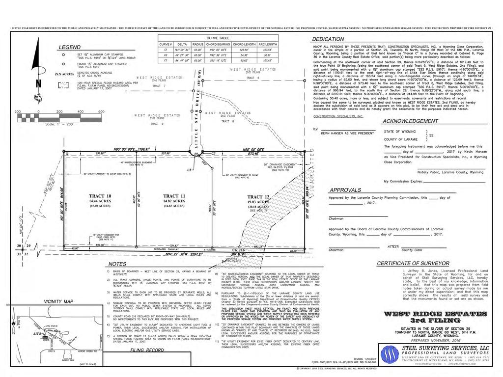
1 LARAMIE COUNTY PLANNING & DEVELOPMENT DEPARTMENT Planning Building MEMORANDUM TO: FROM: Laramie County Planning Commission Jean Vetter, Senior Planner DATE: January 26, 2017 TITLE: Review and action of a Subdivision Permit and Plat for West Ridge Estates 3 rd Filing, located in a portion of Section 29, T. 15 N, R. 68 W, of the 6 th P.M., Laramie County, WY. EXECUTIVE SUMMARY Steil Surveying Services, on behalf of Construction Specialists, Inc., has submitted an application for a Subdivision Permit and Plat for West Ridge Estates 3 rd Filing, situated generally south of the intersection of Little Star Drive & Horse Creek Road. This subdivision would create 3 single-family rural residential lots. BACKGROUND The Laramie County Board of Commissioners approved the West Ridge Estates subdivision permit and plat on April 19, 2016, and the West Ridge Estates 2 nd Filing subdivision permit and plat on August 2, 2016; both plats have subsequently been recorded. Pertinent Regulations Section (a-d) of the Laramie County Land Use Regulations governing the criteria for a subdivision permit. Section (e) of the Laramie County Land Use Regulations governing the criteria for a plat. Page 1 of 6
2 AGENCY REVIEW County Assessor: A more definitive portion of Section 29, such as the South 1/2 South 1/2, seems to be appropriate for the title block. County Real Estate Office: Title block need a more specific legal for what portion of Section 29. As is it is stating ALL of Section 29 County Engineer: 1. I concur with the request for a waiver of a detailed drainage study. However, an engineer should review the plat, site drainage, roadside drainage, etc. to determine if a drainage easement is needed either in Tract 11 or 12 to carry the runoff from the end of the cul de sac to the southeast. 2. I concur with the request for a waiver of a traffic study. 3. Note 7 on the plat indicates there is a portion of Tract 12 that falls within a FEMA floodplain; the approximate floodplain boundary/area should be shown on the plat. County Public Works Department: Additional subdividing and/or road connections in this area will not relieve subsequent plats from requirements pertaining to larger subdivisions Developer indicated private road maintenance plan is being incorporated into HOA docs. Such plan should be submitted for review and approval by Public Works and County Engineer prior to plat being filed. Roads in access easements need to be built to Laramie County road standards. Laramie Co School Dist. No. 1: General: The residential development is within the Central Triad and more specifically: student s home schools for attendance would be Prairie Wind Elementary, McCormick Junior High and Central High Schools. Students living in this development would be eligible for bussing, as they would be beyond the walk distance for each of the schools. School Enrollments: As of the latest enrollment reports, Prairie Wind is near capacity with some space available in some grades, McCormick is below capacity with space available in both grades, Central is below capacity with space available in all grades. Environmental Health Department: WY DEQ Subdivision Regulations Laramie County Small Wastewater System Regulations A completed DEQ Subdivision review and report is needed. This should have been completed with the second filing but filings appear to have been planned to circumvent the DEQ Subdivision Rules Page 2 of 6
3 A copy of the signed final plat with DEQ notes shall be submitted to Environmental Health prior to the issuance of any small wastewater system permit. A USDA soil survey shall be provided to Environmental Health prior to the issuance of any small wastewater system permit. An individual small wastewater permit shall be obtained on each property prior to construction. A perc test and 10 site hole shall be done on each lot prior to issuance of any small wastewater system permit. WYDOT: Access permit for Little Star Drive has been issued for commercial use (more than nine residential lots served.) Permit requires paving of access within WYDOT R/W. Maintain natural drainage paths through the development to prevent concentrating drainage points. Any storm drainage coming into WYDOT R/W must be limited to historic rates. Fire District No. 2: My only concern as stated in previous filings is my concern for one way in and one way out and the lack of water supply for fire protection. Planners: 1. Provide a more specific legal description in the plat title block, as requested by County Assessor and County Real Estate office. 2. Per County Engineer comment, indicate on the plat the approximate floodplain boundary/area. 3. A private road maintenance plan shall be submitted for review and approval by County Public Works and County Engineer prior to recordation of the plat. 4. Upon approval of West Ridge Estates 3rd Filing, the total number of residential lots within the subdivision will equal twelve (12). A second point of access will be required should any further development within West Ridge Estates occur. (LCLUR Sec c (v)) 5. The Owner/Applicant are requesting an exemption from WS for requirement to submit Chapter 23 review to WYDEQ for well and septic with required outcome of "nonadverse" recommendation Subdivision Permits d. Exemptions states: In no case shall the Planning and Development Director exempt an owner from the provisions of W.S if the five (5) or fewer proposed divisions of land are part of a previously exempted division or if there is deliberate attempt to avoid the requirements of (This requirement is not based on tract size but on number of divisions) Page 3 of 6
4 West Ridge Estates 1st Filing (approved ) consisted of 5 divisions and was exempted from these provisions. West Ridge Estates 2nd Filing (approved ) consisted of 4 divisions and was exempted from these provisions. West Ridge Estates 3rd Filing (current application) consists of 3 divisions for a total of 12 divisions of land. Therefore, the current proposed subdivision does not meet the intent for exemption of the DEQ requirement. 6. Fire District No. 2 concerns regarding adequate fire protection water supply and emergency vehicle access/turnaround radius shall be addressed. Provision for a cistern for fire fighting capability in the area is required. The Owner/Applicant shall work with Fire District to include size and location for cistern, and provide an easement, as necessary, on plat prior to recordation. Agencies Responding with No Comments: Combined Communications Center, Cheyenne Light Fuel & Power. Agencies Not Responding: County Treasurer, US Post Office, Emergency Management, Sheriff's Office, CenturyLink. DISCUSSION The Laramie County Comprehensive Plan (2016) describes this area as best suited for Rural Ag Interface (RAI). This category recommends primarily residential development with limited service commercial and retail uses at major intersections. Density of uses should be based on availability and access to water. The Plan also notes that due to lengthy response times, existing topography and limited reliable water resources, cisterns are encouraged in any development within the RAI area as well as utilizing fire-wise planning. The proposed plat would create 3 lots with an average (net) size of acres each. The intended use for the lots is single-family residential. The 3 lots created would require individual well and septic systems. Given the proposed lot size it appears there is adequate area; however, staff makes no assurances that certain permits will be issued, and notes two previous subdivisions were approved for a total of 9 lots immediately adjacent to and north of this 3 rd Filing. Comments were received from agency reviews regarding drainage, road maintenance, requirement to build access easements to Tract 10 to County road standards, requirement to pave in WYDOT ROW for permitted commercial access at Little Star Drive and Horse Creek Road, water supply for fire protection, DEQ small wastewater system requirements, and minor adjustments to information on the plat. A response to the comments has not been received as of the drafting of this report. A copy of the revised plat submitted on January 19, 2017 is attached, Page 4 of 6
5 showing the floodplain area and corrections to the legal description in the title block. Remaining concerns are conditioned below. A sign was posted on the property and notice was sent to adjacent property owners regarding this application. Staff received no public comment regarding this application. The Laramie County Land Use Regulations have criteria for a subdivision permit and plat. This application meets minimum requirements. Staff finds the proposed Subdivision Permit is in conformance with the plans and policies of the Laramie County Comprehensive Plan (2016) and the Laramie County Land Use Regulations (2011). RECOMMENDATION and FINDINGS Based on evidence provided, staff recommends the Planning Commission find that: a. This application meets the criteria for a subdivision permit pursuant to section (a-d) of the Laramie County Land Use Regulations. b. This application meets the criteria for a plat pursuant to section (e) of the Laramie County Land Use Regulations. and that the Planning Commission recommend approval of the Subdivision Permit and Plat for West Ridge Estates 3 rd Filing, located in a portion of Section 29, T. 15 N, R. 68 W, of the 6 th P.M., Laramie County, WY, with the following conditions: Prior to plat recordation: 1. Provide a drainage analysis for review and approval by the County Engineer. 2. Provide civil construction plans for review and approval by County Public Works and County Engineer for all proposed roadways to include those within ingress/egress easements. 3. A private road maintenance plan shall be submitted for review and approval by County Public Works and County Engineer. 4. Add an easement on the plat for a cistern. 5. DEQ approval for septic and well shall be obtained (non-adverse recommendation) and documentation of such approval shall be provided to the Planning Office. 6. The developer shall install a 30,000 gal cistern in the easement indicated on the plat, prior to any building permits being issued for lots within the subdivision OR provide financial assurance for future installation of cistern in the form of non-revocable letter of credit for the dollar amount equal to installation cost of cistern, prior to recordation of the plat. PROPOSED MOTION I move to recommend approval of the Subdivision Permit and Plat for West Ridge Estates 3 rd Filing, located in a portion of Section 29, T. 15 N, R. 68 W, of the 6 th P.M., Laramie County, WY, with conditions 1-6, and adopt the findings of facts a and b of the staff report. Page 5 of 6
6 ATTACHMENTS Attachment 1: Aerial Map Attachment 2: Comprehensive Plan Map Attachment 3: Draft Resolution Attachment 4: Revised Plat January 19, 2017 Page 6 of 6
7 NORTH RIDGE DR Laramie County, Wyoming LITTLE STAR DR HORSE CREEK RD SCENIC RIDGE DR DESPERADO CT RENEGADE CT WEST RIDGE ESTATES 3rd FILING PZ AERIAL MAP Approximate Subject Property Area Printed on Oct 27, 2016 ROAD 113 ROAD 216 ROAD 216 United States Department of Agriculture Feet This map is made possible through the Cheyenne and Laramie County Cooperative GIS Program (CLCCGIS). The data contained herein was collected for its use and is for display and planning purposes only. The CLCCGIS will not be held liable as to the validity, correctness, accuracy, completeness, and/or reliability of the data. The CLCCGIS furthermore assumes no liability associated with the use or misuse of this information.
8 NORTH RIDGE DR Laramie County, Wyoming LITTLE STAR DR HORSE CREEK RD SCENIC RIDGE DR DESPERADO CT RENEGADE CT WEST RIDGE ESTATES 3rd FILING PZ Approximate Subject Property Area RAI Legend Property Lines Future Land Use Districts OTHER Rural Ag Interface (RAI) Subject Properties Printed on January 19, 2017 ROAD 113 ROAD 216 ROAD 216 United States Department of Agriculture Feet This map is made possible through the Cheyenne and Laramie County Cooperative GIS Program (CLCCGIS). The data contained herein was collected for its use and is for display and planning purposes only. The CLCCGIS will not be held liable as to the validity, correctness, accuracy, completeness, and/or reliability of the data. The CLCCGIS furthermore assumes no liability associated with the use or misuse of this information.
9 RESOLUTION NO. A RESOLUTION TO APPROVE A SUBDIVISION PERMIT AND PLAT FOR WEST RIDGE ESTATES 3 RD FILING, LOCATED IN A PORTION OF SECTION 29, T. 15 N, R. 68 W, OF THE 6TH P.M., LARAMIE COUNTY, WY. WHEREAS, Wyoming State Statutes to ; to authorize Laramie County, in promoting the public health, safety, morals and general welfare of the county, to regulate the use of land through zoning in unincorporated Laramie County; and WHEREAS, the Laramie County Board of Commissioners adopted the Laramie County Land Use Regulations; and WHEREAS, the proposed subdivision is in accordance with section (a-d) of the Laramie County Land Use Regulations; and WHEREAS, the proposed plat is in accordance with section (e) of the Laramie County Land Use Regulations; and WHEREAS, this resolution is the subdivision permit for West Ridge Estates 3 rd Filing. NOW THEREFORE BE IT RESOLVED BY THE GOVERNING BODY OF LARAMIE COUNTY, WYOMING, as follows: The Laramie County Board of Commissioners finds that: a. This application is in conformance with section (a-d) of the Laramie County Land Use Regulations. b. This application is in conformance with section (e) of the Laramie County Land Use Regulations. and that the Board approves the Subdivision Permit and Plat for West Ridge Estates 3 rd Filing with the following conditions: Prior to plat recordation: 1. Provide a drainage analysis for review and approval by the County Engineer. 2. Provide civil construction plans for review and approval by County Public Works and County Engineer for all proposed roadways to include those within ingress/egress easements. 3. A private road maintenance plan shall be submitted for review and approval by County Public Works and County Engineer. 4. Add an easement on the plat for a cistern. 5. DEQ approval for septic and well shall be obtained (non-adverse recommendation) and documentation of such approval shall be provided to the Planning Office. 6. The developer shall install a 30,000 gal cistern in the easement indicated on the plat, prior to any building permits being issued for lots within the subdivision OR provide financial assurance for future installation of cistern in the form of non-revocable letter of credit for the dollar amount equal to installation cost of cistern, prior to recordation of the plat. PRESENTED, READ AND ADOPTED THIS DAY OF, LARAMIE COUNTY BOARD OF COMMISSIONERS ATTEST: Troy Thompson, Chairman Debra K. Lee, Laramie County Clerk 1
10 Reviewed and approved as to form: Mark T. Voss, Laramie County Attorney 2
11
LARAMIE COUNTY PLANNING & DEVELOPMENT DEPARTMENT
 LARAMIE COUNTY PLANNING & DEVELOPMENT DEPARTMENT Planning Building MEMORANDUM TO: FROM: Laramie County Planning Commission Bryan Nicholas, Associate Planner DATE: April 11, 2019 TITLE: Review and action
LARAMIE COUNTY PLANNING & DEVELOPMENT DEPARTMENT
 LARAMIE COUNTY PLANNING & DEVELOPMENT DEPARTMENT Planning Building MEMORANDUM TO: FROM: Laramie County Planning Commission Nancy M. Trimble, Associate Planner DATE: July 13, 2017 TITLE: Review and action
LARAMIE COUNTY PLANNING & DEVELOPMENT DEPARTMENT
 LARAMIE COUNTY PLANNING & DEVELOPMENT DEPARTMENT Planning Building MEMORANDUM TO: FROM: Laramie County Planning Commission Nancy M. Trimble, Associate Planner DATE: November 9, 2017 TITLE: Review and action
LARAMIE COUNTY PLANNING & DEVELOPMENT DEPARTMENT
 LARAMIE COUNTY PLANNING & DEVELOPMENT DEPARTMENT Planning Building MEMORANDUM TO: FROM: Laramie County Board of Commissioners Brad Emmons, Planning Director DATE: May 15, 2018 TITLE: Review and action
LARAMIE COUNTY PLANNING & DEVELOPMENT DEPARTMENT
 LARAMIE COUNTY PLANNING & DEVELOPMENT DEPARTMENT Planning Building MEMORANDUM TO: FROM: Laramie County Planning Commission Nancy M. Trimble, Associate Planner DATE: November 9, 2017 TITLE: Review and action
LARAMIE COUNTY PLANNING & DEVELOPMENT DEPARTMENT
 LARAMIE COUNTY PLANNING & DEVELOPMENT DEPARTMENT Planning Building MEMORANDUM TO: FROM: Laramie County Planning Commission Marissa Pomerleau, Planning Technician DATE: March 28, 2019 TITLE: Review and
LARAMIE COUNTY PLANNING & DEVELOPMENT DEPARTMENT
 LARAMIE COUNTY PLANNING & DEVELOPMENT DEPARTMENT Planning Building MEMORANDUM TO: FROM: Laramie County Board of Commissioners Nancy Trimble, Associate Planner DATE: July 18, 2017 TITLE: Review and action
LARAMIE COUNTY PLANNING & DEVELOPMENT DEPARTMENT
 LARAMIE COUNTY PLANNING & DEVELOPMENT DEPARTMENT Planning Building MEMORANDUM TO: FROM: Laramie County Planning Commission Bryan Nicholas, Associate Planner DATE: February 14, 2019 TITLE: Review and action
LARAMIE COUNTY PLANNING & DEVELOPMENT DEPARTMENT
 LARAMIE COUNTY PLANNING & DEVELOPMENT DEPARTMENT Planning Building MEMORANDUM TO: FROM: Laramie County Planning Commission Brett Walker, Planner DATE: January 25, 2018 TITLE: Review and action of a Subdivision
LARAMIE COUNTY PLANNING & DEVELOPMENT DEPARTMENT
 LARAMIE COUNTY PLANNING & DEVELOPMENT DEPARTMENT Planning Building MEMORANDUM TO: FROM: Laramie County Planning Commission Seth Frentheway, Associate Planner DATE: August 23, 2018 TITLE: Review and recommendations
LARAMIE COUNTY PLANNING & DEVELOPMENT DEPARTMENT
 LARAMIE COUNTY PLANNING & DEVELOPMENT DEPARTMENT Planning Building MEMORANDUM TO: FROM: Laramie County Planning Commission Brett Walker, Planner DATE: January 25, 2018 TITLE: Review and action of a Variance
LARAMIE COUNTY PLANNING & DEVELOPMENT DEPARTMENT
 LARAMIE COUNTY PLANNING & DEVELOPMENT DEPARTMENT Planning Building MEMORANDUM TO: FROM: Laramie County Planning Commission Bryan Nicholas, Associate Planner DATE: November 9, 2017 TITLE: Review and action
LARAMIE COUNTY PLANNING & DEVELOPMENT DEPARTMENT
 LARAMIE COUNTY PLANNING & DEVELOPMENT DEPARTMENT Planning Building MEMORANDUM TO: FROM: Laramie County Planning Commission Brad Emmons, Planning Director DATE: March 22, 2018 TITLE: Review and recommendations
LARAMIE COUNTY PLANNING & DEVELOPMENT DEPARTMENT
 LARAMIE COUNTY PLANNING & DEVELOPMENT DEPARTMENT Planning Building MEMORANDUM TO: FROM: Laramie County Board of Commissioners Nancy M. Trimble, Associate Planner DATE: December 5, 2017 TITLE: Review and
LARAMIE COUNTY PLANNING & DEVELOPMENT DEPARTMENT
 LARAMIE COUNTY PLANNING & DEVELOPMENT DEPARTMENT Planning Building MEMORANDUM TO: FROM: Laramie County Board of Commissioners Bryan Nicholas, Associate Planner DATE: May 15, 2018 TITLE: Review and action
LARAMIE COUNTY PLANNING & DEVELOPMENT DEPARTMENT
 LARAMIE COUNTY PLANNING & DEVELOPMENT DEPARTMENT Planning Building MEMORANDUM TO: FROM: Laramie County Planning Commission Nancy Trimble, Associate Planner DATE: July 13, 2017 TITLE: Review and action
LARAMIE COUNTY PLANNING & DEVELOPMENT DEPARTMENT
 LARAMIE COUNTY PLANNING & DEPARTMENT Planning Building MEMORANDUM TO: FROM: Laramie County Planning Commission Nancy M. Trimble, Associate Planner DATE: December 14, 2017 TITLE: Review and action of a
LARAMIE COUNTY PLANNING & DEVELOPMENT DEPARTMENT
 LARAMIE COUNTY PLANNING & DEVELOPMENT DEPARTMENT Planning Building MEMORANDUM TO: FROM: Laramie County Planning Commission Seth Frentheway, Associate Planner DATE: November 8, 2018 TITLE: Review and action
LARAMIE COUNTY PLANNING & DEVELOPMENT DEPARTMENT
 LARAMIE COUNTY PLANNING & DEVELOPMENT DEPARTMENT Planning Building MEMORANDUM TO: FROM: Laramie County Board of Commissioners Bryan Nicholas, Associate Planner DATE: October 2, 2018 TITLE: Review and action
LARAMIE COUNTY PLANNING & DEVELOPMENT DEPARTMENT
 LARAMIE COUNTY PLANNING & DEVELOPMENT DEPARTMENT Planning Building MEMORANDUM TO: FROM: Laramie County Planning Commission Bryan Nicholas, Associate Planner DATE: September 27, 2018 TITLE: Review and action
LARAMIE COUNTY PLANNING & DEVELOPMENT DEPARTMENT
 LARAMIE COUNTY ANNING & DEVELOPMENT DEPARTMENT Planning Building MEMORANDUM TO: FROM: Laramie County Board of Commissioners Seth Frentheway, Associate Planner DATE: June 19 th, 2018 TITLE: Review and action
LARAMIE COUNTY PLANNING & DEVELOPMENT DEPARTMENT
 LARAMIE COUNTY PLANNING & DEVELOPMENT DEPARTMENT Planning Building MEMORANDUM TO: FROM: Laramie County Planning Commission Seth Frentheway, Associate Planner DATE: August 23, 2018 TITLE: Review and action
LARAMIE COUNTY PLANNING & DEVELOPMENT DEPARTMENT
 LARAMIE COUNTY PLANNING & DEVELOPMENT DEPARTMENT Planning Building MEMORANDUM TO: FROM: Laramie County Board of Commissioners Bryan Nicholas, Associate Planner DATE: October 16, 2018 TITLE: Review and
Minutes of the Proceedings Laramie County Planning Commission Prepared by the Laramie County Planning & Development Office Laramie County Wyoming
 Minutes of the Proceedings Laramie County Planning Commission Prepared by the Laramie County Planning & Development Office Laramie County Wyoming Thursday, January 12, 2012 120112 00 The Laramie County
STAFF REPORT - SUMMATION. Saddle Ridge, 7 th Filing. Preliminary Plat Process CASE NUMBER: UDC SUBDIVISION CODE: SDRA-P
 STAFF REPORT - SUMMATION Saddle Ridge, 7 th Filing Preliminary Plat Process CASE NUMBER: UDC-15-00351 SUBDIVISION CODE: SDRA-P PREPARED BY: MEETING DATES: Josh Tetzlaff July 6, 2015 Planning Commission
SUBDIVISION REGULATIONS
 CHAPTER 14 SUBDIVISION REGULATIONS 14-100 Provisions 14-200 Preliminary Plat 14-300 Final Plat 14-400 Replat 14-500 Minor Subdivision 14-600 Administrative Replat 14-700 Vacation of Roadways, Public Easements,
PLANNING AND ZONING COMMISSION VARIANCE
 PLANNING AND ZONING COMMISSION VARIANCE DOÑA ANA COUNTY COMMUNITY DEVELOPMENT DEPARTMENT Doña Ana County Government Center 845 N. Motel Blvd. Las Cruces, New Mexico 88007 Telephone: (575) 647-7350 MEETING
DOÑA ANA COUNTY PLANNING AND ZONNING COMMISSION
 DOÑA ANA COUNTY PLANNING AND ZONNING COMMISSION Doña Ana County Government Complex 845 N. Motel Blvd. Las Cruces, New Mexico 88007 Office: (575) 647-7350 MEETING DATE: June 22, 2017 REQUEST: Variance CASE
ORDINANCE NO. BE IT ORDAINED BY THE GOVERNING BODY OF THE CITY OF CHEYENNE, WYOMING: That the City of Cheyenne hereby finds as follows:
 ORDINANCE NO. ENTITLED: AN ORDINANCE ANNEXING TO THE CITY OF CHEYENNE, WYOMING, A PARCEL OF LAND SITUATED IN THE NORTH 102 FEET OF TRACTS 323 AND 324, SUNNYSIDE ADDITION, 7TH FILING, LARAMIE COUNTY, WYOMING
Planning Department Oconee County, Georgia
 Planning Department Oconee County, Georgia STAFF REPORT REZONE CASE #: 6985 DATE: October 31, 2016 STAFF REPORT BY: Andrew C. Stern, Planner APPLICANT NAME: Williams & Associates, Land Planners PC PROPERTY
MINERAL COUNTY PLANNING STAFF FINDINGS OF FACT Proposed Elk Run at St. Regis. February 12, 2017
 MINERAL COUNTY PLANNING STAFF FINDINGS OF FACT Proposed The proposed is a five-lot subdivision and is located approximately one mile east of St. Regis on Old Highway 10 East. The property is located in
The Laramie County Land Use Regulations
 LARAMIE COUNTY, WYOMING Formatted The Laramie County Land Use Regulations Title 2 County-Wide Land use Regulations 5/24/2018 pg. Adopted February 15, 2011 Table of Contents Title 2 County Wide Land Use
MONTGOMERY COUNTY PLANNING BOARD
 MONTGOMERY COUNTY PLANNING BOARD T H E MARYLAND-NATIONAL CAPITAL PARK A N D P L A N N I N G C O M M I S S I O N MCPB NO. 10-144 Hearing Date: September 30, 2010 MONTGOMERY COUNTY PLANNING BOARD RESOLUTION
Town of Prairie du Sac Sauk County, WI. Land Division Ordinance 07-3
 Town of Prairie du Sac Sauk County, WI Land Division Ordinance 07-3 1.01 DISCLAIMER (1) Multiple Jurisdictions. All persons reviewing the provisions of this Ordinance should be aware that the Town of Prairie
Guide to Replats. Step 1. Step 2. Step 3. Step 4. Step 5. Step 6. Step 7. Step 8. Step 9. Step 10
 Guide to Replats Introduction Douglas County is committed to providing open, transparent application processes to the public. This Guide is provided to assist anyone interested in the procedures and expectations
Article 2 Application Type and Standards Requirements
 Article 1 Article 2 Division 1 Application Type and Standards Requirements General Provisions Sec. 2.1.1 Division 2 Division 3 Division 4 Division 5 Division 6 Division 7 Division 8 Division 9 Sec. 2.9.1
DEPARTMENT OF PLANNING SERVICES 1555 N 17 th Ave Greeley CO Phone (970) Fax (970)
 Fax (970)") DEPARTMENT OF PLANNING SERVICES 1555 N 17 th Ave Greeley CO 80631 Phone (970) 400-6100 Fax (970) 304-6498 SITE SPECIFIC DEVELOPMENT PLAN USE BY SPECIAL REVIEW PROCEDURAL GUIDE SOLID WASTE DISPOSAL SITES
DEPARTMENT OF PLANNING SERVICES 1555 N 17 th Ave Greeley CO 80631 Phone (970) 400-6100 Fax (970) 304-6498 SITE SPECIFIC DEVELOPMENT PLAN USE BY SPECIAL REVIEW PROCEDURAL GUIDE SOLID WASTE DISPOSAL SITES
PLANNING AND ZONING COMMISSION VARIANCE
 PLANNING AND ZONING COMMISSION VARIANCE DOÑA ANA COUNTY COMMUNITY DEVELOPMENT DEPARTMENT Doña Ana County Government Center 845 N. Motel Blvd. Las Cruces, New Mexico 88007 Telephone: (575) 647-7350 MEETING
AGENDA ITEM SUMMARY BUSINESS OF THE CITY COUNCIL CITY OF GOLDEN, COLORADO. Quasi Judicial Matter
 AGENDA ITEM SUMMARY BUSINESS OF THE CITY COUNCIL CITY OF GOLDEN, COLORADO Quasi Judicial Matter MEETING DATE: July 10, 2014 REPORT DATE: June 30, 2014 CASE NO: PC 14-26 DEPT. OF ORIGIN: Community and Economic
DAUPHIN CREEK ESTATES SUBDIVISION
 # 12 SUB-000076-2017 DAUPHIN CREEK ESTATES SUBDIVISION Engineering Comments: FINAL PLAT COMMENTS (should be addressed prior to submitting the FINAL PLAT for review and/or signature by the City Engineer):
Parcel Map Review Committee Staff Report Meeting Date: October 13, 2016
 Subject: Applicant: Agenda Item Number: Project Summary: Recommendation: Parcel Map Review Committee Staff Report Meeting Date: October 13, 2016 Parcel Map Case Number Spanish Springs Associates Ltd. Ptsp.
YELLOWSTONE COUNTY BOARD OF PLANNING FINDINGS OF FACT
 YELLOWSTONE COUNTY BOARD OF PLANNING FINDINGS OF FACT The City-County Planning staff has prepared the Findings of Fact for the Aspen Ridge Subdivision, 2 nd Filing. These findings are based on the preliminary
Marion County Board of County Commissioners
 Marion County Board of County Commissioners Date: 4/26/26 P&Z: 4/25/26 BCC: 5/17/26 Item Number 160509Z Type of Application Request to rezone the property from the Rural Commercial (RC-1) District to the
BOARD OF COUNTY COMMISSIONERS ARCHULETA COUNTY, COLORADO RESOLUTION 2018-
 BOARD OF COUNTY COMMISSIONERS ARCHULETA COUNTY, COLORADO RESOLUTION 2018- ARCHULETA COUNTY IMPROPERLY DIVIDED PARCELS EXEMPTION INTERIM RESOLUTION - A RESOLUTION ADDRESSING PARCELS UNDER THE SIZE OF 35
Parcel Map Review Committee Staff Report Meeting Date: May 12, 2016
 Subject: Applicant: Agenda Item Number: Project Summary: Recommendation: Parcel Map Review Committee Staff Report Meeting Date: May 12, 2016 Tentative Parcel Map Case Number TL Mt. Rose Estates, LP 7C
Amendment to the Zoning and Subdivision Ordinances; Consider Repeal Cluster Development Standards
 2 Board of Supervisors Meg Bohmke, Chairman Gary F. Snellings, Vice Chairman Jack R. Cavalier Thomas C. Coen L. Mark Dudenhefer Wendy E. Maurer Cindy C. Shelton February 28, 2018 Thomas C. Foley County
THE COUNTY BOARD OF SUPERVISORS OF THE COUNTY OF DOUGLAS DOES ORDAIN AS FOLLOWS:
 8.1 SUBDIVISION CONTROL ORDINANCE THE COUNTY BOARD OF SUPERVISORS OF THE COUNTY OF DOUGLAS DOES ORDAIN AS FOLLOWS: SECTION I. GENERAL INTERPRETATION This ordinance shall not repeal, impair or modify private
Board Summary Report
 Board of County Commissioners: Public Hearing Agenda, August 7, 2018 Agenda Item: # Date: July 25, 2018 To: Through: From: Subject: Board of County Commissioners Jan Yeckes, Planning Division Manager Bill
, Assistant County Attorney. when the following proceedings, among others were had and done, to-wit: RESOLUTION NO.
 STATE OF COLORADO ) )ss County of Garfield ) At a regular meeting of the Board of County Commissioners for Garfield County, Colorado, held in the Commissioners' Meeting Room, Garfield County Administration
KENDALL COUNTY LAND CASH ORDINANCE
 KENDALL COUNTY LAND CASH ORDINANCE Last Revised April 15, 2014 (Ordinance 2014-09) Prior Updates: (Amended July 15, 2013- Ord. 2013-16, complete overhaul) (Amended May 19, 2009- Ord. 2009-16) (Amended
BEFORE THE HEARING EXAMINER FOR THURSTON COUNTY
 COUNTY COMMISSIONERS Cathy Wolfe District One Diane Oberquell District Two Robert N. Macleod District Three HEARING EXAMINER BEFORE THE HEARING EXAMINER FOR THURSTON COUNTY In the Matter of the Application
Parcel Map Review Committee Staff Report
 Parcel Map Review Committee Staff Report Meeting Date: October 11, 2018 Agenda Item: 7A TENTATIVE PARCEL MAP CASE NUMBER: (Larkins) BRIEF SUMMARY OF REQUEST: Request to divide one parcel of ±1.084-acres
MINOR SUBDIVISION FINAL PLAT APPLICATION Town of Apex, North Carolina
 MINOR SUBDIVISION FINAL PLAT APPLICATION Town of Apex, North Carolina This document is a public record under the North Carolina Public Records Act and may be published on the Town s website or disclosed
Planning & Zoning Commission
 Planning & Zoning Commission Planning & Development Department August 14, 01 Zoning Map Amendment MAP-1-0001 (Bay View Section 4) Request Rezone approximately 1.19 acres from OS (Open Space) to RSF- (Residential
BEFORE THE HEARING EXAMINER FOR THURSTON COUNTY
 COUNTY COMMISSIONERS Cathy Wolfe District One Diane Oberquell District Two Robert N. Macleod District Three HEARING EXAMINER BEFORE THE HEARING EXAMINER FOR THURSTON COUNTY In the Matter of the Application
(if more than one, give square footage for each) ANNEXATION LOT LINE Adjustments PRE/FINAL PLAT SPECIAL USE PERMIT
 ANNEXATION LOT LINE Adjustments PRE/FINAL PLAT SPECIAL USE PERMIT") Planning Commission Application Building & development office 915 Third ST. Rawlins WY ph. 307-328-4599 fax. 307-328-4590 PROJECT REVIEW: GENERAL INFORMATION Project name: OFFICE USE ONLY Site address
Planning Commission Application Building & development office 915 Third ST. Rawlins WY ph. 307-328-4599 fax. 307-328-4590 PROJECT REVIEW: GENERAL INFORMATION Project name: OFFICE USE ONLY Site address
APPLICATION FOR SUBDIVISION APPROVAL OF A SKETCH PLAN with checklist
 Prior to filing any application for SUBDIVISION approval, the applicant shall request in writing that the zoning administrator schedule a pre-submission conference. APPLICATION TO THE PLANNING BOARD TOWN
Project File #: SF Project Name: Jackson Ranch Filing No. 4 Parcel Nos.: , and
 COMMISSIONERS: DARRYL GLENN (PRESIDENT) MARK WALLER (PRESIDENT PRO TEMPORE) STAN VANDERWERF LONGINOS GONZALEZ PEGGY LITTLETON PLANNING AND COMMUNITY DEVELOPMENT DEPARTMENT CRAIG DOSSEY, EXECUTIVE DIRECTOR
COUNCIL COMMUNICATION
 Meeting Date: October 24, 2017 COUNCIL COMMUNICATION Agenda Item: Agenda Location: Public Hearings Work Plan # Legal Review: X 1 st Reading 2 nd Reading Subject: A public hearing regarding Zoning and a
IV. REVIEW PROCEDURES FOR MINOR SUBDIVISIONS
 IV. REVIEW PROCEDURES FOR MINOR SUBDIVISIONS IV-A. General Minor subdivisions create five or fewer lots from a tract of record, each lot of which has legal and physical access. If the tract of record proposed
ORDINANCE NO.: Adopted: August 2, 2005 Amended: March 27, 2007 Amended: September 23, Fillmore County Rural Addressing Ordinance
 ORDINANCE NO.: 2005-01 Adopted: August 2, 2005 Amended: March 27, 2007 Amended: September 23, 2008 Fillmore County Rural Addressing Ordinance Section 1 Purpose, Scope and Statutory Authorization 1-1 Purpose.
Guide to Preliminary Plans
 Guide to Preliminary Plans Introduction The Douglas County is committed to providing open, transparent application processes to the public. This Guide is provided to assist anyone interested in the procedures
Town of Norwich, Vermont SUBDIVISION REGULATIONS
 Town of Norwich, Vermont SUBDIVISION REGULATIONS Adopted: August 6, 2002 Amended: February 8, 2006 Prepared by Norwich Planning Commission with the assistance of: Burnt Rock Inc. A ssociates in Community
MUNICIPAL BUILDING 2101 O Neil Avenue Cheyenne, WY
 MUNICIPAL BUILDING 2101 O Neil Avenue Cheyenne, WY 82001 http://www.cheyennecity.org To view agenda backup items select the following link: http://cheyenne.granicus.com/generatedagendaviewer.php?view_id=5&event_id=687
HERON LANDING SUBDIVISION
 HERON LANDING SUBDIVISION Engineering Comments: Per FEMA guidelines, any development greater than 5 acres in size or subdivision 50 lots in size, requires a flood study. Width of drainage easement to be
MASTER SUBDIVISION FINAL PLAT APPLICATION Town of Apex, North Carolina
 MASTER SUBDIVISION FINAL PLAT APPLICATION Town of Apex, North Carolina This document is a public record under the North Carolina Public Records Act and may be published to the Town s website or disclosed
ORDINANCE NO. _4.06 AN ORDINANCE TO ESTABLISH BUILDING SITE REGULATIONS SECTION A PURPOSE AND INTENT
 ORDINANCE NO. _4.06 AN ORDINANCE TO ESTABLISH BUILDING SITE REGULATIONS SECTION A PURPOSE AND INTENT This Ordinance provides minimum regulations, provisions and requirements for safe, aesthetically pleasing
Parcel Map Review Committee Staff Report Meeting Date: October 8, 2015
 Parcel Map Review Committee Staff Report Meeting Date: October 8, 2015 Subject: Applicant: Agenda Item Number: Project Summary: Recommendation: Parcel Map Case Number Reeves Business Ventures 7D Divide
Parcel Map Review Committee Staff Report Meeting Date: March 12, 2015
 Parcel Map Review Committee Staff Report Meeting Date: March 12, 2015 Subject: Applicant(s): Agenda Item Number: Project Summary: Recommendation: Prepared by: Parcel Map Case Number Eric and Rebecca Swanson
RESOLUTION R EAST COUNTY MIDDLE SCHOOL SCHOOL SITE PLAN SSP DTS
 RESOLUTION R-18-003 EAST COUNTY MIDDLE SCHOOL SCHOOL SITE PLAN SSP-17-02 DTS20170502 A RESOLUTION OF THE BOARD OF COUNTY COMMISSIONERS OF MANATEE COUNTY, FLORIDA, REGARDING LAND DEVELOPMENT; ALLOWING FOR
CITY OF SANTA CLARITA PLANNING COMMISSION AGENDA REPORT. SUBJECT: Master Case No ; Tentative Parcel Map No
 Agenda Item: 1 CITY OF SANTA CLARITA PLANNING COMMISSION AGENDA REPORT PUBLIC HEARINGS PLANNING MANAGER APPROVAL: DATE: October 4, 2016 SUBJECT: Master Case No. 16-120; Tentative Parcel Map No. 74183 APPLICANT:
Initial Project Review
 Pierce County Department of Planning and Land Services, 2401 South 35th Street, Tacoma, WA (253) 798-7037 Initial Project Review Major Amendment to Preliminary Plat: Hawks Ridge Division 1 Application
BONNER COUNTY PLANNING DEPARTMENT PLANNING & ZONING COMMISION STAFF REPORT APRIL 19, 2018
 BONNER COUNTY PLANNING DEPARTMENT PLANNING & ZONING COMMISION STAFF REPORT APRIL 19, 2018 Project Name: File Number,Type: Request: Legal Description: Location: Parcel Size: Parcel # Applicant: Project
City of Fort Lupton Amended Plat Process
 City of Fort Lupton Amended Plat Process Purpose The Amended Plat process is an administrative process to amend a recorded Plat. An Amended Subdivision is an administrative revision to a recorded Subdivision
CITY OF MERCED Planning & Permitting Division
 CITY OF MERCED Planning & Permitting Division STAFF REPORT: #12-11 AGENDA ITEM: 4.1 FROM: Kim Espinosa, PLANNING COMMISSION Planning Manager MEETING DATE: June 20, 2012 PREPARED BY: Julie Nelson, Planner
Minutes of the Proceedings Laramie County Planning Commission Prepared by the Laramie County Planning & Development Office Laramie County Wyoming
 Minutes of the Proceedings Laramie County Planning Commission Prepared by the Laramie County Planning & Development Office Laramie County Wyoming Thursday, April 10, 2014 140410 00 The Laramie County Planning
Plat Checklist PLAT TYPES AND DESCRIPTIONS
 Master Plan / Revision to Master Plan (For Platting Purposes Only) Preliminary/Final Plat Preliminary Plat Final Plat Minor Plat Replat Amended Plat Plat Checklist So that we may efficiently review your
Legal Description Part of the Western Half of the Eastern Half of the Northwest Quarter of Section 30, Le Ray Township
 Owner and Applicant s 20448 State Highway 83 Mankato, MN 56001 Request and Location Request for review and approval of a Conditional Use Permit to allow an Elder Care Residential Unit to be constructed
BRIDGETON SUBDIVISION APPLICATION CHECKLIST
 APPLICATION NAME AND # CHECKLIST COMPLETED BY: DATE: Signature and printed name BRIDGETON SUBDIVISION APPLICATION CHECKLIST TO SUBDIVISION APPLICANTS: The attached checklist is to assist you in the submission
SUBDIVISION REGULATIONS for Lawrence and the Unincorporated Areas of Douglas County, KS
 SUBDIVISION REGULATIONS for Lawrence and the Unincorporated Areas of Douglas County, KS December 19, 2006 Edition Amended: 09/11/07; 12/04/07; 03/25/08; 09/10/08 Amended: January 6, 2009 Article 8 Subdivision
PARK COUNTY PLANNING COMMISSION PLANNING DEPARTMENT STAFF REPORT
 PARK COUNTY PLANNING COMMISSION PLANNING DEPARTMENT STAFF REPORT Planning Commission Hearing Date: July 14, 2015 To: Planning Commissioners Date: July 8, 2015 Prepared by: Subject: Request: Jill Falchi,
PLANNING COMMISSION STAFF REPORT June 18, 2015
 Community Development Department Planning Division 1600 First Street + P.O. Box 660 Napa, CA 94559-0660 (707) 257-9530 PLANNING COMMISSION STAFF REPORT June 18, 2015 AGENDA ITEM 7.B. PL15-0052 PM, GASSER
STAFF REPORT FOR MAJOR SUBDIVISION
 STAFF REPORT FOR MAJOR SUBDIVISION FINAL PLAT CASE NO. FA-12-003 HEARING DATE: November 6, 2013 CASE NAME: Solterra Subdivision Filing No. 13 PROCEDURE: Planning Commission ADDRESS OF MAJOR SUBDIVISION
All roads developed to access four (4) or more parcels shall be constructed to Park County Road and Bridge Standards.
 or more parcels shall be constructed to Park County Road and Bridge Standards.") P a r k C o u n t y P l a n n i n g a n d Z o n i n g 1002 Sheridan Avenue Cody, WY 82414 Phone: 307-527-8540 35-40 ACRE SUBDIVISIONS www.parkcounty.us/planandzone.htm May 2011 This is only intended as
P a r k C o u n t y P l a n n i n g a n d Z o n i n g 1002 Sheridan Avenue Cody, WY 82414 Phone: 307-527-8540 35-40 ACRE SUBDIVISIONS www.parkcounty.us/planandzone.htm May 2011 This is only intended as
STAFF REPORT FOR MAJOR SUBDIVISION
 STAFF REPORT FOR MAJOR SUBDIVISION FINAL PLAT CASE NO. FA-13-001 HEARING DATE: November 6, 2013 CASE NAME: Solterra Subdivision Filing No. 14 PROCEDURE: Planning Commission ADDRESS OF MAJOR SUBDIVISION
Staff Report: Date: Applicant: Property Identification: Acreage of Request: Current Zoning of Requested Area: Requested Action: Attached:
 Staff Report: Completed by Jeff Palmer Director of Planning & Zoning Date: November 7, 2018, Updated November 20, 2018 Applicant: Greg Smith, Oberer Land Developer agent for Ronald Montgomery ET AL Property
Guide to Minor Developments
 Guide to Minor Developments Introduction The Douglas County (DCD) is committed to providing open, transparent application processes to the public. This Guide is provided to assist anyone interested in
STAFF REPORT FOR MAJOR SUBDIVISION
 STAFF REPORT FOR MAJOR SUBDIVISION FINAL PLAT CASE NO. FA-12-002 HEARING DATE: September 5, 2012 CASE NAME: Solterra Subdivision Filing No. 12 PROCEDURE: Planning Commission ADDRESS OF MAJOR SUBDIVISION
201 General Provisions
 201 General Provisions 201.01 Title 201.09 Amendments 201.02 Purpose and Intent 201.10 Public Purpose 201.03 Authority 201.11 Variances and Appeals 201.04 Jurisdiction 201.12 Nonconformances 201.05 Enactment
FINAL PLAT SUBMITTAL CHECKLIST
 FINAL PLAT SUBMITTAL CHECKLIST The submission requirements for a Final Plat Review are found beginning in Section 24-4-40 of the Weld County Code. The Weld County Code is available on line at www.co.weld.co.us
RESOLUTION NO. R
 RESOLUTION NO. R-2016-1832 RESOLUTION APPROVING ZONING APPLICATION ZV/DOAlR-2016-00660 (CONTROL NO. 1998-00089) a Requested Use APPLICATION OF 2860 Ranch House Road LLC, Scotts Gas LLC, Ranch House Prop
Staff Report: Date: Applicant: Property Identification: Acreage of Request: Current Zoning of Requested Area: Requested Action: Attached:
 Staff Report: Completed by Jeff Palmer Director of Planning & Zoning Date: November 7, 2018 Applicant: Greg Smith, Oberer Land Developer agent for Ronald Montgomery ET AL Property Identification: Frontage
April 19, Planning and Land Development Regulation Commission (PLDRC)
") Page 1 of 15 GROWTH AND RESOURCE MANAGEMENT DEPARTMENT PLANNING AND DEVELOPMENT SERVICES DIVISION 123 W. Indiana Avenue, DeLand, FL 32720 (386) 736-5959 PLDRC HEARING: CASE NO: SUBJECT: LOCATION: APPLICANT:
Page 1 of 15 GROWTH AND RESOURCE MANAGEMENT DEPARTMENT PLANNING AND DEVELOPMENT SERVICES DIVISION 123 W. Indiana Avenue, DeLand, FL 32720 (386) 736-5959 PLDRC HEARING: CASE NO: SUBJECT: LOCATION: APPLICANT:
MINOR SUBDIVISION COMMITTEE COUNTY OF MONTEREY, STATE OF CALIFORNIA
 MINOR SUBDIVISION COMMITTEE COUNTY OF MONTEREY, STATE OF CALIFORNIA RESOLUTION NO. 05010 In the matter the application GIANNINI FAMILY LIMITED PARTNERSHIP (PLN040273) APN# 113-071-006-000 FINDINGS & DECISION
SUBDIVISION REGULATIONS
 SUBDIVISION REGULATIONS for Lawrence and the Unincorporated Areas of Douglas County, KS Regulations Governing Land Divisions in the City of Lawrence and the Unincorporated Areas of Douglas County, Kansas
BYRON TOWNSHIP ZONING APPLICATION
 BYRON TOWNSHIP ZONING APPLICATION Phone: (616) 878-9104 * Fax: (616) 878-3980 * Website: www.byrontownship.org This application will not be accepted if incomplete. APPLICATION FOR & REQUIRED COPIES Private
WESTMINSTER PARK SUBDIVISION
 WESTMINSTER PARK SUBDIVISION Engineering Comments: FINAL PLAT COMMENTS (should be addressed prior to submitting the FINAL PLAT for review and/or signature by the City Engineer): A. Provide all of the required
Instructions for Residential Building Permit Application
 Instructions for Residential Building Permit Application Sublette County, Wyoming Processing Procedure: Paperwork Use this application for residential homes and accessory structures. A Sufficient Building
WESTMINSTER PARK PLACE SUBDIVISION
 WESTMINSTER PARK PLACE SUBDIVISION Engineering Comments: FINAL PLAT COMMENTS (should be addressed prior to submitting the FINAL PLAT for review and/or signature by the City Engineer): A. Provide all of
a. It is the intent of these regulations to encourage the preservation of natural resources and facilitate orderly growth in the County.
 Part V Transfer of Development Rights Section 246. 1. Intent a. It is the intent of these regulations to encourage the preservation of natural resources and facilitate orderly growth in the County. b.