Parcel Map Review Committee Staff Report
|
|
|
- Clementine Lamb
- 5 years ago
- Views:
Transcription
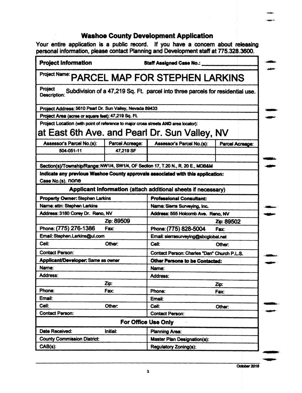
1 Parcel Map Review Committee Staff Report Meeting Date: October 11, 2018 Agenda Item: 7A TENTATIVE PARCEL MAP CASE NUMBER: (Larkins) BRIEF SUMMARY OF REQUEST: Request to divide one parcel of ±1.084-acres into three parcels of ±16,810 sq. ft., ±14,807 sq. ft. and ±15,586 sq. ft. STAFF PLANNER: Kelly Mullin, AICP, Senior Planner CASE DESCRIPTION For possible action, hearing, and discussion to approve a parcel map dividing one parcel of ±1.084-acres into three parcels of ±16,810 sq. ft., ±14,807 sq. ft. and ±15,586 sq. ft. Applicant/Owner: Stephen Larkins Location: 5610 Pearl Dr., at the northeast corner of its intersection with 6 th Ave. APN: Parcel Size: ±1.084-acres Master Plan: Suburban Residential Regulatory Zone: Medium Density Suburban Area Plan: Sun Valley CAB: Sun Valley Development Code: Authorized in Article 606, Parcel Maps Commission District: 3 Commissioner Jung STAFF RECOMMENDATION APPROVE APPROVE WITH CONDITIONS DENY POSSIBLE MOTION I move that, after giving reasoned consideration to the information contained within the staff report and the information received during the public meeting, that the Washoe County Parcel Map Review Committee approve Parcel Map Case Number, subject to the conditions of approval included as Exhibit A with the staff report, and make the determination that the following criteria are or will be adequately provided for pursuant to Washoe County Code Section (Motion with Findings on Page 9) Post Office Box 11130, Reno, NV E. Ninth St., Reno, NV Telephone: Fax: LARKINS
2 Washoe County Parcel Map Review Committee Staff Report Date: September 27, 2018 Staff Report Contents Parcel Map Purpose and Process... 3 Site Plan... 4 Map of Existing Structures on Site... 5 Tentative Parcel Map Evaluation... 6 Sun Valley Area Plan Modifiers... 6 Development Information... 6 Reviewing Agencies... 7 Staff Comments on Required Findings... 7 Recommendation... 9 Possible Motion... 9 Appeal Process Exhibit Contents Conditions of Approval... Exhibit A Agency Comments... Exhibit B Project Application... Exhibit C Tentative Parcel Map Case Number Page 2 of 10 LARKINS
3 Washoe County Parcel Map Review Committee Staff Report Date: September 27, 2018 Parcel Map Purpose and Process The purpose of a parcel map is to allow for the creation of subdivisions, merger and re-subdivision of existing lots, and common-interest communities consisting of four or fewer parcels pursuant to Washoe County Code (WCC) Chapter 110, Article 606, Parcel Maps. A tentative parcel map must be submitted to the Planning and Building Division for the purpose of review prior to or concurrent with the final parcel map. Every tentative parcel map must be prepared by a professional land surveyor. The parcel map process exists to establish reasonable standards of design and procedures for subdividing in order to further the orderly layout and use of land and insure proper legal descriptions and monumenting of subdivided land. Additionally, the process helps to safeguard the public health, safety and general welfare by establishing minimum standards of design and development for any land division platted in the unincorporated area of Washoe County. If the Washoe County Parcel Map Review Committee grants an approval of the tentative parcel map, that approval is subject to Conditions of Approval. Conditions of Approval are requirements that may need to be completed during different stages of the proposed project. Those stages are typically: Prior to recordation of a final map. Prior to obtaining a final inspection and/or a certificate of occupancy on a structure. Prior to the issuance of a business license or other permits/licenses. Some Conditions of Approval are referred to as Operational Conditions. These conditions must be continually complied with for the life of the project. Within 22 months from the date of approval of the tentative parcel map, the applicant must file a final parcel map along with any required supporting materials with the Planning and Building Division and the County Engineer showing that all conditions imposed by the Washoe County Parcel Map Review Committee have been met. Approval or conditional approval of a tentative parcel map imposes no obligation on the part of the Director of the Planning and Building Division or the Washoe County Board of Commissioners to approve the final parcel map or to accept any public dedication shown on the tentative or final parcel map. Failure to submit a complete final parcel map and pay the required fees within the two year time period shall cease any further action on the map and shall render the tentative parcel map as expired. The recommended conditions of approval for Tentative Parcel Map Case Number are attached to this staff report as Exhibit A and will be included with the Action Order if approved by the Parcel Map Review Committee. The subject property has a regulatory zone of Medium Density Suburban, which allows up to three dwelling units per acre, with a minimum lot size of 12,000 square feet, per WCC Section The current request is to divide a ±1.084-acre parcel into three parcels of ±16,810 sq. ft., ±14,807 sq. ft. and ±15,586 sq. ft. Tentative Parcel Map Case Number Page 3 of 10 LARKINS
4 Washoe County Parcel Map Review Committee Staff Report Date: September 27, 2018 Site Plan Tentative Parcel Map Case Number Page 4 of 10 LARKINS
5 Washoe County Parcel Map Review Committee Staff Report Date: September 27, 2018 Map of Existing Structures on Site Tentative Parcel Map Case Number Page 5 of 10 LARKINS
6 Washoe County Parcel Map Review Committee Staff Report Date: September 27, 2018 Tentative Parcel Map Evaluation Regulatory Zone: Medium Density Suburban Maximum Lot Potential: 3 Number of Lots on Parcel Map: 3 Minimum Lot Size Required: Minimum Lot Size on Parcel Map: Minimum Lot Width Required: 12,000 sq. ft. 14,807 sq. ft. 80 feet Minimum Lot Width on Parcel Map: 95 feet The tentative parcel map meets all minimum requirements for the Medium Density Suburban regulatory zone. Development Suitability Constraints: The Sun Valley Development Suitability Map, a part of the Sun Valley Area Plan, identifies the subject parcel as most suitable for development. However, a small portion of the southeastern corner of proposed Parcel 3 is located within a 100-year flood hazard area. Any development in this area will be required to comply with the applicable standards. Hydrographic Basin: The subject parcel is within the Sun Valley Hydrographic Basin. The subject parcel is inside the Truckee Meadows Service Area (TMSA). The proposed subdivision is not a second or subsequent division of a parcel map approved within the last five years. Sun Valley Area Plan Modifiers The subject parcel is located within the Sun Valley Area Plan and this tentative parcel map is subject to the following standards: WCC Section (a) requires residential development of one unit or more per acre be served by community water and sewer facilities. Additionally, Section mandates that new parcels may only be created in areas serviced by recognized water purveyors. The proposed parcel is currently served by Sun Valley General Improvement District and the new parcels will continue to be serviced by that provider. Development Information The application states that the subject parcel is currently developed with three single family homes and several detached accessory structures. However, the applicant-provided survey of existing conditions show a total of four residences on the property, with two of those residences located on proposed Parcel 2. A recommended condition of approval has been included with Exhibit A that requires the second home on Parcel 2 to be removed prior to the recordation of the map. Alternatively, the applicant may obtain a special use permit for a detached accessory dwelling in order to legalize the second dwelling. The required setbacks for the Medium Density Suburban regulatory zone are 20-feet for front and rear yards and 8-feet for the side yards. The primary residences on each proposed parcel meet Tentative Parcel Map Case Number Page 6 of 10 LARKINS
7 Washoe County Parcel Map Review Committee Staff Report Date: September 27, 2018 these required setbacks. However, the second home on Parcel 2 and several of the detached accessory structures do not. A recommended condition of approval has been included with Exhibit A requiring all structures to meet setback standards prior to recordation of the final map. Reviewing Agencies The following agencies received a copy of the project application for review and evaluation. Washoe County Community Services Department o Planning and Building Division o Engineering and Capital Projects Division o Parks and Open Space o Utilities o Water Rights Sun Valley General Improvement District (SVGID) Washoe County Health District o Air Quality Management Division o Environmental Health Services Division Truckee Meadows Fire Protection District Regional Transportation Commission (RTC) Washoe-Storey Conservation District NV Energy and Charter Communications Four of the above-listed agencies/departments provided comments and/or recommended conditions of approval in response to their evaluation of the project application. A summary of each agency s comments and/or recommended conditions of approval and their contact information is provided. The Conditions of Approval document is attached to this staff report and will be included with the Action Order, if granted approval. Washoe County Planning and Building Division requires the final map be in substantial compliance with the tentative parcel map, for all structures to meet setback and density standards, and for the provision of services to be by SVGID. Contacts: Kelly Mullin, , kmullin@washoecounty.us and Vahid Behmaram, , vbehmaram@washoecounty.us Washoe County Engineering and Capital Projects Division provided comments related to drainage, flood plain standards technical map requirements. Contact: Mike Gump, , mgump@washoecounty.us Washoe County Health District identified they had no concerns with the proposal due to the parcels being served by municipal water and sewer. Contact: Wes Rubio, , wrubio@washoecounty.us Staff Comments on Required Findings WCC Section (i) requires that all of the following findings be made to the satisfaction of the Washoe County Parcel Map Review Committee before granting approval of the request. Staff has completed an analysis of the application and has determined that the proposal is in compliance with the required findings as follows. 1) General improvement considerations for all parcel maps including, but not limited to: Tentative Parcel Map Case Number Page 7 of 10 LARKINS
8 Washoe County Parcel Map Review Committee Staff Report Date: September 27, 2018 a) Environmental and health laws and regulations concerning water and air pollution, the disposal of solid waste, facilities to supply water, community or public sewage disposal and, where applicable, individual systems for sewage disposal. Staff Comment: Compliance with all applicable environmental and health laws and regulations concerning water and air pollution, the disposal of solid waste, facilities to supply water, and sewage disposal will be ensured prior to recordation of the final map or prior to approval of a development permit on the subject site. The application was reviewed by the Health District, and water and sewer service will be provided by the Sun Valley General Improvement District. b) The availability of water which meets applicable health standards and is sufficient for the reasonably foreseeable needs of the subdivision. Staff Comment: The existing and proposed lots are and will continue to be served by the Sun Valley General Improvement District. c) The availability and accessibility of utilities. Staff Comment: The existing and proposed lots are and will continue to be served by municipal water and sewer. Power will be provided through NV Energy. d) The availability and accessibility of public services such as schools, police and fire protection, transportation, recreation and parks. Staff Comment: The proposed parcel map would divide an existing parcel into a total of three lots, which are anticipated to have minimal impacts on local services. The application was provided for review by fire and transportation agencies and no adverse comments were received. e) Conformity with the zoning ordinances and master plan. Staff Comment: The proposed division of land is in conformance with the applicable provisions of the Washoe County Development Code and Master Plan, and the regulatory zoning on the property. f) General conformity with the governing body s master plan of streets and highways. Staff Comment: The application was reviewed by the Planning and Building Division, Engineering and Capital Projects Division, and Regional Transportation Commission, and no adverse comments were received. The proposal is in conformance with the Area Plan and Master Plan for streets and highways. g) The effect of the proposed subdivision on existing public streets and the need for new streets or highways to serve the subdivision. Staff Comment: The application was reviewed by the Washoe County Engineering and Capital Projects Division and the Regional Transportation Commission, and no recommendations for new streets or highways to serve the subdivision were received. h) Physical characteristics of the land such as floodplain, slope and soil. Staff Comment: The subject parcel is relatively flat and has already been developed. A small portion of the southeast corner of Parcel 3 is located within the 100-year floodplain. Any future development will be required to comply with all applicable policies. i) The recommendations and comments of those entities reviewing the tentative parcel map pursuant to NRS and , inclusive. Staff Comment: These provisions of statute refer to the preparation and distribution of tentative maps. All recommend conditions of approval from the reviewing agencies have been included with the staff report. Tentative Parcel Map Case Number Page 8 of 10 LARKINS
9 Washoe County Parcel Map Review Committee Staff Report Date: September 27, 2018 j) The availability and accessibility of fire protection including, but not limited to, the availability and accessibility of water and services for the prevention and containment of fires including fires in wild lands. Staff Comment: The application was reviewed by the Truckee Meadows Fire Protection District and no comments were received. k) Community antenna television (CATV) conduit and pull wire. Staff Comment: The application was provided to Charter Communications for review, and no comments were received. l) Recreation and trail easements. Staff Comment: The proposal was provided to Washoe County Parks and Open Space for review, and no comments were received. The Sun Valley Recreational Opportunities Plan map does not identify any recreational features on or nearby the subject property. Recommendation Those agencies which reviewed the application, recommended conditions in support of approval of the tentative parcel map. Therefore, after a thorough analysis and review, Parcel Map Case Number is recommended for approval with conditions. Staff offers the following motion for the Parcel Map Review Committee s consideration. Possible Motion I move that, after giving reasoned consideration to the information contained within the staff report and the information received during the public meeting, that the Washoe County Parcel Map Review Committee approve Parcel Map Case Number for Stephen Larkins, subject to the conditions of approval included as Exhibit A with the staff report, and make the determination that the following criteria is or will be adequately provided for pursuant to Washoe County Code, Section : 1) General improvement considerations for all parcel maps including, but not limited to: a) Environmental and health laws and regulations concerning water and air pollution, the disposal of solid waste, facilities to supply water, community or public sewage disposal and, where applicable, individual systems for sewage disposal; b) The availability of water which meets applicable health standards and is sufficient for the reasonably foreseeable needs of the subdivision; c) The availability and accessibility of utilities; d) The availability and accessibility of public services such as schools, police and fire protection, transportation, recreation and parks; e) Conformity with the zoning ordinances and master plan; f) General conformity with the governing body s master plan of streets and highways; g) The effect of the proposed subdivision on existing public streets and the need for new streets or highways to serve the subdivision; h) Physical characteristics of the land such as floodplain, slope and soil; i) The recommendations and comments of those entities reviewing the tentative parcel map pursuant to NRS and , inclusive; j) The availability and accessibility of fire protection including, but not limited to, the availability and accessibility of water and services for the prevention and containment of fires including fires in wild lands; Tentative Parcel Map Case Number Page 9 of 10 LARKINS
10 Washoe County Parcel Map Review Committee Staff Report Date: September 27, 2018 k) Community antenna television (CATV) conduit and pull wire; and l) Recreation and trail easements. Appeal Process Parcel Map Review Committee action will be effective 10 calendar days after the written decision is filed with the Secretary to the Parcel Map Review Committee, unless the action is appealed to the Washoe County Board of County Commissioners, in which case the outcome of the appeal shall be determined by the Board of County Commissioners. Any appeal must be filed in writing within 10 calendar days from the date the written decision is filed with and signed by the Secretary of the Parcel Map Review Committee and mailed to the applicant. Applicant/Owner: Stephen Larkins 3180 Corey Dr. Reno, NV Consultant: Sierra Surveying Attn: Dan Church 555 Holcombe Ave. Reno, NV Tentative Parcel Map Case Number Page 10 of 10 LARKINS
11 Conditions of Approval Tentative Parcel Map Case Number The tentative parcel map approved under Parcel Map Case Number shall be carried out in accordance with the Conditions of Approval granted by the Washoe County Parcel Map Review Committee on October 11, Conditions of Approval are requirements placed on a permit or development by each reviewing agency. These Conditions of Approval may require submittal of documents, applications, fees, inspections, amendments to plans, and more. These conditions do not relieve the applicant of the obligation to obtain any other approvals and licenses from relevant authorities required under any other act or to abide by all other generally applicable Codes, and neither these conditions nor the approval by the County of this project/use override or negate any other applicable restrictions on uses or development on the property. Unless otherwise specified, all conditions related to the approval of this tentative parcel map shall be met or financial assurance must be provided to satisfy the conditions of approval prior to the recordation of a final parcel map. The agency responsible for determining compliance with a specific condition shall determine whether the condition must be fully completed or whether the applicant shall be offered the option of providing financial assurance. All agreements, easements, or other documentation required by these conditions shall have a copy filed with the County Engineer and the Planning and Building Division. Compliance with the conditions of approval related to this tentative parcel map is the responsibility of the applicant, his/her successor in interest, and all owners, assignees, and occupants of the property and their successors in interest. Failure to comply with any of the conditions imposed in the approval of the tentative parcel map may result in the institution of revocation procedures. Washoe County reserves the right to review and revise the Conditions of Approval related to this tentative parcel map should it be determined that a subsequent license or permit issued by Washoe County violates the intent of this approval. For the purpose of conditions imposed by Washoe County, may is permissive and shall or must is mandatory. Conditions of Approval are usually complied with at different stages of the proposed project. Those stages are typically: Prior to recordation of a final map. Prior to obtaining a final inspection and/or a certificate of occupancy. Prior to the issuance of a business license or other permits/licenses. Some Conditions of Approval are referred to as Operational Conditions. These conditions must be continually complied with for the life of the project. FOLLOWING ARE CONDITIONS OF APPROVAL REQUIRED BY THE REVIEWING AGENCIES. EACH CONDITION MUST BE MET TO THE SATISFACTION OF THE ISSUING AGENCY. Post Office Box 11130, Reno, NV E. Ninth St., Reno, NV Telephone: Fax: EXHIBIT A
12 Washoe County Parcel Map Review Committee Conditions of Approval Washoe County Planning and Building Division 1. The following conditions are requirements of the Planning and Building Division, which shall be responsible for determining compliance with these conditions. General Conditions Contact: Kelly Mullin, , a. The final map shall be in substantial compliance with all plans and documents submitted as part of this tentative parcel map application, and with any amendments imposed by the Parcel Map Review Committee. All documentation necessary to satisfy the conditions noted below shall accompany the final map when submitted to the County Engineer and the Planning and Building Division. b. The applicant shall comply with all the conditions of approval and shall submit a final map for signature by the Director of the Planning and Building Division within 22 months from the date of approval by the Parcel Map Review Committee. Each agency responsible for imposing conditions may determine whether its conditions must be fully completed or whether the applicant shall be offered the option of providing financial assurances as a means of assuring compliance. c. The final map shall contain the following jurat: DIRECTOR OF PLANNING AND BUILDING CERTIFICATE THE FINAL PARCEL MAP CASE NO. MEETS ALL APPLICABLE STATUTES, ORDINANCES AND CODE PROVISIONS; IS IN SUBSTANTIAL CONFORMANCE WITH THE TENTATIVE MAP AND ITS CONDITIONS, WHICH ARE INCORPORATED HEREIN BY THIS REFERENCE, AND THOSE CONDITIONS HAVE BEEN SATISFIED FOR RECORDATION OF THIS MAP. THE OFFER(S) OF DEDICATION IS (ARE) REJECTED AT THIS TIME, BUT WILL REMAIN OPEN IN ACCORDANCE WITH NEVADA REVISED STATUTES CHAPTER 278. THIS FINAL MAP IS APPROVED AND ACCEPTED THIS DAY OF, 20, BY THE DIRECTOR OF PLANNING AND BUILDINIG OF WASHOE COUNTY, NEVADA, IN ACCORDANCE WITH NEVADA REVISED STATUTES THROUGH MOJRA HAUENSTEIN, DIRECTOR, PLANNING AND BUILDING DIVISION d. Any regulations, procedures, and conditions adopted by the Washoe County Health District must be met prior to recordation of a final map. e. The applicant has indicated that the proposed improvements will not exceed the major grading thresholds that require a special use permit. If the final construction drawings for the map include grading that exceeds the Major Grading Permit Thresholds listed in Article 438 Grading Standards, the applicant shall apply for a special use permit for grading; and if approved, may be delayed up to three months processing time. In addition, all related standards within the Washoe County Development Code shall be met on the construction drawings. f. The approval for this tentative parcel map does not include improvements for driveways to building pads. Grading for access to building pads, if they exceed the criteria stated in the previous condition, shall require a special use permit. Tentative Parcel Map Case Number Page 2 of 3 EXHIBIT A
13 Washoe County Parcel Map Review Committee Conditions of Approval g. Prior to recordation of the final map, the applicant shall provide evidence that all existing dwellings and structures on the property meet all required setbacks per the standards of the Washoe County Development Code. h. Prior to recordation of the final map, the applicant shall either remove the second dwelling on Parcel 2, or comply with Washoe County Development Code standards and obtain a special use permit for a detached accessory dwelling. There is no guarantee that a special use permit will be granted. Water Rights Condition Contact: Vahid Behmaram, , vbehmaram@washoecounty.us i. The Parcel Map shall contain Sun Valley General Improvement District s note and acknowledgement regarding all conditions necessary for provision of water service to these parcels prior to approval of building permit. A valid will serve from SVGID for the newly created parcels is also acceptable. Washoe County Engineering and Capital Projects 2. The following conditions are requirements of the Engineering and Capital Projects, which shall be responsible for determining compliance with these conditions. Contact: Mike Gump, , mgump@washoecounty.us a. Comply with the conditions of the Washoe County technical check for this map. Technical Map Check is subject to further review b. Add a graphic border around the proposed division. c. Dash all lines that are not a part of the division. d. Add a note to the map stating: No habitable structures shall be located on a fault that was active during the Holocene Epoch of geological time. e. Add the FEMA floodplain to the map. f. Add the following note to the map; All properties, regardless if they are located within or outside of a FEMA designated flood zone, may be subject to flooding. The property owner is required to maintain all drainage easements and natural drainages and not perform or allow unpermitted and unapproved modifications to the property that may have detrimental impacts to surrounding properties. *** End of Conditions *** Tentative Parcel Map Case Number Page 3 of 3 EXHIBIT A
14 COMMUNITY SERVICES DEPARTMENT Engineering and Capital Projects 1001 EAST 9 TH STREET PO BOX RENO, NEVADA PHONE (775) FAX (775) INTEROFFICE MEMORANDUM DATE: September 11, 2018 PARCEL MAP REVIEW TO: FROM: SUBJECT: Kelly Mullin, Senior Planner - Department of Community Services Mike Gump, PLS, Engineering and Capital Projects Division Parcel Map for: Stephen Larkins Parcel Map Case No.: APN: Review Date: September 5, 2018 The Engineering and Capital Projects Division has reviewed the subject parcel map and the following conditions must be successfully completed prior to final approval of this application by the Division. 1. Comply with the conditions of the Washoe County technical check for this map. Technical Map Check is subject to further review 2. Add a graphic border around the proposed division. 3. Dash all lines that are not a part of the division. 4. Add a note to the map stating: No habitable structures shall be located on a fault that was active during the Holocene Epoch of geological time. 5. Add the FEMA floodplain to the map. 6. Add the following note to the map; All properties, regardless if they are located within or outside of a FEMA designated flood zone, may be subject to flooding. The property owner is required to maintain all drainage easements and natural drainages and not perform or allow unpermitted and unapproved modifications to the property that may have detrimental impacts to surrounding properties. EXHIBIT B
 Project description: The applicant is requesting to approve a parcel map dividing one")
 recommends approval of this project with the following comments and Water Rights conditions: Comments: 1) This")
 The Parcel Map shall contain SVGID s note and acknowledgement regards all conditions necessary for provision of water service to these parcels prior to approval of building permit.")
15 COMMUNITY SERVICES P.O. Box Reno, Nevada Phone: (775) Fax: (775) August 28, 2018 TO: FROM: SUBJECT: Kelly Mullin, AICP, Senior Planner, CSD, Planning & Building Division Vahid Behmaram, Water Management Planner Coordinator, CSD Tentative Parcel Map Case Number (Larkins) Project description: The applicant is requesting to approve a parcel map dividing one parcel of ±1.084-acres into three parcels of ±16,810 sq. ft., ±14,807 sq. ft. and ±15,586 sq. ft. The parcel is located at 5610 Pearl Dr., at the northeast corner of its intersection with 6th Ave., Assessor s Parcel Number: The Community Services Department (CSD) recommends approval of this project with the following comments and Water Rights conditions: Comments: 1) This application indicates the project will annex to and receive water service from Sun Valley GID. Conditions: 1) The Parcel Map shall contain SVGID s note and acknowledgement regards all conditions necessary for provision of water service to these parcels prior to approval of building permit. Or a valid will serve from SVGID for the newly created parcel is also acceptable E. 9 TH Street, Reno, Nevada EXHIBIT B
 has reviewed the above referenced project.")
16 September 19, 2018 Kelly Mullin, Planner Washoe County Community Services Planning and Development Division PO Box Reno, NV RE: Larkins; APN Special Use Permit; Dear Ms. Mullin: The Washoe County Health District, Environmental Health Services Division (WCHD) has reviewed the above referenced project. The following conditions are requirements of the Washoe County Health District, Environmental Health Division, which shall be responsible for determining compliance with these conditions. Contact Name Wesley Rubio, , a. WCHD has no objections to the approval of this project as proposed. All parcels are to be served by municipal water and sewer. If you have any questions or would like clarification regarding the foregoing, please contact Wes Rubio, Senior Environmental Health Specialist at regarding all Health District comments. Sincerely, James English, REHS, CP-FS EHS Supervisor Waste Management/Land Development Programs JE:wr ENVIRONMENTAL HEALTH SERVICES 1001 East Ninth Street I P.O. Box I Reno, Nevada I Fax: I washoecounty.us/health Serving Reno, Sparks and all of Washoe County, Nevada Washoe County is an Equal Opportunity Employer EXHIBIT B
17 EXHIBIT C
18 EXHIBIT C
19 EXHIBIT C
20 EXHIBIT C
21 EXHIBIT C
22 EXHIBIT C
23 EXHIBIT C
24 EXHIBIT C
25 EXHIBIT C
26 EXHlBIT "A" Legal Description All that certain real property situate in the City of Reno, County of Washoe, State of NEVADA, described as follows: Lot 11, in Block G of SUN VALLEY SUBDIVISION NO. 5, according to the official map thereof, filed in the office of the County Recorder of Washoe County, State of Nevada, on January 14, APN: End of Report EXHIBIT C
27 PARCEL 1 LOT CLOSURE.txt Lot Report Thu Aug 02 09:17: Lot File: J:\ \DWG\ lot CRD File: J:\ \SS 2016\ ZAK Lot: PROPOSED LOT, Block: 0, Type: LOT PNT# Bearing Distance Northing Easting Station S 89 22'01" E S 00 43'26" W N 89 22'01" W N 00 45'33" E Closure Error Distance> Total Distance> Area: Sq. Feet, 0.39 Acres Block 0 Total Area: Sq. Feet, 0.39 Acres EXHIBIT C
28 PARCEL 2 LOT CLOSURE.txt Lot Report Thu Aug 02 09:17: Lot File: J:\ \DWG\ lot CRD File: J:\ \SS 2016\ ZAK Lot: PROPOSED LOT, Block: 1006, Type: LOT PNT# Bearing Distance Northing Easting Station S 89 22'17" E S 00 43'26" W N 89 22'17" W N 00 43'26" E Closure Error Distance> Total Distance> Area: Sq. Feet, 0.36 Acres Block 1006 Total Area: Sq. Feet, 0.36 Acres EXHIBIT C
29 PARCEL 3 LOT CLOSURE.txt Lot Report Thu Aug 02 09:17: Lot File: J:\ \DWG\ lot CRD File: J:\ \SS 2016\ ZAK Lot: PROPOSED LOT 2, Block: 0, Type: LOT PNT# Bearing Distance Northing Easting Station S 89 22'35" E S 00 43'26" W N 89 22'34" W N 00 43'26" E Closure Error Distance> Total Distance> Area: Sq. Feet, 0.34 Acres Block 0 Total Area: Sq. Feet, 0.34 Acres EXHIBIT C
30 EXHIBIT C
31 EXHIBIT C
Parcel Map Review Committee Staff Report Meeting Date: October 13, 2016
 Subject: Applicant: Agenda Item Number: Project Summary: Recommendation: Parcel Map Review Committee Staff Report Meeting Date: October 13, 2016 Parcel Map Case Number Spanish Springs Associates Ltd. Ptsp.
Parcel Map Review Committee Staff Report Meeting Date: May 12, 2016
 Subject: Applicant: Agenda Item Number: Project Summary: Recommendation: Parcel Map Review Committee Staff Report Meeting Date: May 12, 2016 Tentative Parcel Map Case Number TL Mt. Rose Estates, LP 7C
Parcel Map Review Committee Staff Report Meeting Date: October 8, 2015
 Parcel Map Review Committee Staff Report Meeting Date: October 8, 2015 Subject: Applicant: Agenda Item Number: Project Summary: Recommendation: Parcel Map Case Number Reeves Business Ventures 7D Divide
Parcel Map Review Committee Staff Report Meeting Date: March 12, 2015
 Subject: Applicant(s): Agenda Item Number: Parcel Map Review Committee Staff Report Meeting Date: March 12, 2015 Parcel Map Case Number William and Maryanne Paganetti 7B Project Summary: Dividing a 14.2
Parcel Map Review Committee Staff Report Meeting Date: March 12, 2015
 Parcel Map Review Committee Staff Report Meeting Date: March 12, 2015 Subject: Applicant(s): Agenda Item Number: Project Summary: Recommendation: Prepared by: Parcel Map Case Number Eric and Rebecca Swanson
Parcel Map Review Committee Staff Report Meeting Date: June 8, 2017
 Parcel Map Review Committee Staff Report Meeting Date: June 8, 2017 Subject: Applicant/Owner: Agenda Item Number: Project Summary: Recommendation: Parcel Map Case Number Dyke and Beth Kauffmann 7C Divide
Parcel Map Review Committee Staff Report Meeting Date: April 13, 2017
 Parcel Map Review Committee Staff Report Meeting Date: April 13, 2017 Subject: Applicant: Agenda Item Number: Project Summary: Recommendation: Prepared by: Parcel Map Case Number Christy Corporation 7A
Board of Adjustment Staff Report Meeting Date: June 1, 2017
 Board of Adjustment Staff Report Meeting Date: June 1, 2017 Subject: Applicant: Agenda Item Number: Summary: Recommendation: Prepared by: Phone: E-Mail: Administrative Permit Case Number Powning Family
Administrative Permit Staff Report Meeting Date: February 2, 2017
 Administrative Permit Staff Report Meeting Date: February 2, 2017 Subject: Applicant: Agenda Item Number: Summary: Recommendation: Administrative Permit Case Number WADMIN16-0001 Carlson and Associates
DRAFT. 1. Determination of Quorum Eric Young called the meeting to order at 1:31 p.m. The following members and staff were present:
 WASHOE COUNTY PARCEL MAP REVIEW COMMITTEE Meeting Minutes Parcel Map Review Committee Members Thursday, December 8, 2016 1:30 p.m. James Barnes, Planning Commission James English, Health District Tim Simpson,
Detached Accessory Dwelling Administrative Review Staff Report Date: August 26, 2014
 Detached Accessory Dwelling Administrative Review Staff Report Subject: Detached Accessory Dwelling Administrative Review Case No: DADAR14-04 Applicant(s): Nick Gibson Summary: To establish a Detached
Planning Commission Staff Report Meeting Date: February 2, 2016
 Planning Commission Staff Report Meeting Date: February 2, 2016 Subject: Applicant(s): Agenda Item Number: Summary: Recommendation: Abandonment Case Number Gary and Rachel Bullock 9B To allow the abandonment
Board of Adjustment Staff Report Meeting Date: April 4, 2013
 Board of Adjustment Staff Report Meeting Date: April 4, 2013 Subject: Applicant(s): Agenda Item No. Project Summary: Recommendation: Prepared by: Variance Case No: VA13-001 Gary R. Taylor on behalf of
Memorandum: October 13, 2008 REVISED To: Trowbridge Township Planning Commission From: P. Hudson, AICP Re: Suggested New Ordinance
 1 Memorandum: October 13, 2008 REVISED 2-11-09 To: Trowbridge Township Planning Commission From: P. Hudson, AICP Re: Suggested New Ordinance Because of changes in both the Michigan Planning Enabling Act
LYON COUNTY COMMUNITY DEVELOPMENT DEPARTMENT
 LYON COUNTY COMMUNITY DEVELOPMENT DEPARTMENT B UILDING D EVELOPMENT E NGINEERING P LANNING 27 S. MAIN S TREET Y ERINGTON, NEVADA 89447 (775) 463-6591 F AX: (775) 463-5305 34 LAKES B OULEVARD D AYTON, NEVADA
LYON COUNTY TITLE 15 LAND USE AND DEVELOPMENT CODE LAND DIVISION REGULATIONS CHAPTERS October 19, 2017 Ordinance Draft DRAFT
 DRAFT LYON COUNTY TITLE 15 LAND USE AND DEVELOPMENT CODE LAND DIVISION REGULATIONS CHAPTERS 15.600 15.607 October 19, 2017 Ordinance Draft This page left blank intentionally DRAFT DRAFT Lyon County Contents
Planning Commission Staff Report Meeting Date: September 6, 2016
 Planning Commission Staff Report Meeting Date: September 6, 2016 Subject: Applicant(s): Agenda Item Number: Project Summary: Recommendation: Tentative Subdivision Map Case Number: Spanish Springs Associates,
Board of Adjustment Staff Report Meeting Date: February 5, 2015
 Board of Adjustment Staff Report Meeting Date: February 5, 2015 Subject: Applicants: Agenda Item Number Project Summary: Recommendation: Variance Case Number: Lawrence and Judith Romiti 7A Reduce the front
ELK RAPIDS TOWNSHIP ANTRIM COUNTY, MICHIGAN ORDINANCE NO
 ELK RAPIDS TOWNSHIP ANTRIM COUNTY, MICHIGAN ORDINANCE NO. 3-2011 AN ORDINANCE TO REPLACE THE SUBDIVISION CONTROL ORDINANCE WITH A NEW SUBDIVISION DEVELOPMENT ORDINANCE, IN ACCORD WITH THE LAND DIVISION
Chapter 100 Planned Unit Development in Corvallis Urban Fringe
 100.100 Scope and Purpose. Chapter 100 Planned Unit Development in Corvallis Urban Fringe (1) All applications for land divisions in the Urban Residential (UR) and Flood Plain Agriculture (FPA) zones within
NYE COUNTY, NV PAHRUMP REGIONAL PLANNING COMMISSION REGULAR MEETING JANUARY 11, 2017
 CASE DESCRIPTION(S): LOCATION: APN NUMBER(S): AP# 045-021-59 NYE COUNTY, NV PAHRUMP REGIONAL PLANNING COMMISSION REGULAR MEETING JANUARY 11, 2017 a. For Possible Action TM-2016-00004: Tentative Map application
LAND USE APPLICATION
 Lincoln County Department of Planning & Development 210 SW 2nd Street, Newport, OR 97365 Phone (541) 265-4192 Fax (541) 265-6945 LAND USE APPLICATION TO BE COMPLETED BY STAFF Conditional Use Non-Conforming
Community Services Department BOUNDARY LINE ADJUSTMENT APPLICATION
 Community Services Department Planning and Building BOUNDARY LINE ADJUSTMENT APPLICATION Community Services Department Planning and Building 1001 E. Ninth St., Bldg. A Reno, NV 89520 Telephone: 775.328.6100
1.0 REQUEST. SANTA BARBARA COUNTY ZONING ADMINISTRATOR Coastal Zone Staff Report for Vincent New Single-Family Dwelling & Septic System
 SANTA BARBARA COUNTY ZONING ADMINISTRATOR Coastal Zone Staff Report for Vincent New Single-Family Dwelling & Septic System Hearing Date: February 26, 2007 Supervisorial District: First Staff Report Date:
UPPER MOUNT BETHEL TOWNSHIP NORTHAMPTON COUNTY, PENNSYLVANIA
 UPPER MOUNT BETHEL TOWNSHIP NORTHAMPTON COUNTY, PENNSYLVANIA JOINDER DEED / LOT CONSOLIDATION TOWNSHIP REVIEW PROCESS When accepting proposed Joinder Deeds / Lot Consolidations, review the Joinder Deed
ARTICLE 1 GENERAL PROVISIONS
 ARTICLE 1 GENERAL PROVISIONS SECTION 100 TITLE This Ordinance shall be known and cited as the "Rice Township Subdivision and Land Development Ordinance." SECTION 101 AUTHORITY Rice Township is empowered
FINAL DRAFT 12/1/16, Rev. to 7/18/17
 FINAL DRAFT 12/1/16, Rev. to 7/18/17 (As Adopted 8/8/17 Effective 9/1/17) SHELTON PLANNING AND ZONING COMMISSION Proposed Amendments to Zoning Regulations I. Amend Section 23 PERMITTED USES by inserting
MINOR SUBDIVISION COMMITTEE COUNTY OF MONTEREY, STATE OF CALIFORNIA
 MINOR SUBDIVISION COMMITTEE COUNTY OF MONTEREY, STATE OF CALIFORNIA RESOLUTION NO. 05010 In the matter the application GIANNINI FAMILY LIMITED PARTNERSHIP (PLN040273) APN# 113-071-006-000 FINDINGS & DECISION
INTERLOCAL AGREEMENT PERMITTING CONSTRUCTION OF SOUTHEAST CONNECTOR ON THE TRUCKEE MEADOWS WATER RECLAMATION FACILITY
 INTERLOCAL AGREEMENT PERMITTING CONSTRUCTION OF SOUTHEAST CONNECTOR ON THE TRUCKEE MEADOWS WATER RECLAMATION FACILITY This Agreement Permitting Construction of SouthEast Connector on the Truckee Meadows
COUNTY OF SANTA BARBARA PLANNING AND DEVELOPMENT MEMORANDUM. Santa Barbara County Planning Commission
 COUNTY OF SANTA BARBARA PLANNING AND DEVELOPMENT MEMORANDUM TO: FROM: HEARING DATE: RE: Santa Barbara County Planning Commission Florence Trotter-Cadena, Planner III North County Development Review October
Community Services Department TENTATIVE PARCEL MAP PARCEL MAP WAIVER APPLICATION
 Community Services Department Planning and Building TENTATIVE PARCEL MAP (see page 5) PARCEL MAP WAIVER (see page 15) APPLICATION Community Services Department Planning and Building 1001 E. Ninth St.,
TOWN OF WATERVILLE VALLEY NEW HAMPSHIRE SITE PLAN REVIEW REGULATIONS
 TOWN OF WATERVILLE VALLEY NEW HAMPSHIRE Effective date March 17, 1981 Revised March 16, 1982 Revised March 13, 1986 Revised March 10, 1987 Revised March 14, 2013 Revised March 8, 2016 TOWN OF WATERVILLE
TENTATIVE MAP INFORMATION SHEET
 TENTATIVE MAP INFORMATION SHEET GENERAL INFORMATION This information sheet explains how your Tentative Map application will be processed, what fees you must pay, and what plans you must submit. If you
CONDOMINIUM REGULATIONS
 ARTICLE 37 CONDOMINIUM REGULATIONS SECTION 37.01. Purpose The purpose of this Article is to regulate projects that divide real property under a contractual arrangement known as a condominium. New and conversion
CHAPTER 3 PERMITS, PLANS AND ANNEXATION
 CHAPTER 3 PERMITS, PLANS AND ANNEXATION SECTION: 10-3-1: General Regulations 10-3-2: Building Permit 10-3-3: Plans 10-3-4: Certificate of Compliance and Occupancy 10-3-5: Conditional Use Permits 10-3-6:
STAFF REPORT # CONDITIONAL USE PLANNING COMMISSION MEETING DATE: July 20, 2017
 STAFF REPORT #17-4000-0005 CONDITIONAL USE PLANNING COMMISSION MEETING DATE: July 20, 2017 1. APPLICATION: An application submitted by Stephanie Moye requesting a conditional use permit to allow for a
ARTICLE 24 SITE PLAN REVIEW
 ARTICLE 24 SITE PLAN REVIEW 24.1 PURPOSE: The intent of these Ordinance provisions is to provide for consultation and cooperation between the land developer and the Township Planning Commission in order
All items include discussion and possible action to approve, modify, deny, or continue unless marked otherwise.
 Jim Hindle Chairman Jim Collins Planning Commissioner Larry Prater Planning Commissioner Summer Pellett- Planning Commissioner Storey County Planning Commission Meeting Agenda Thursday November 1, 2018
COUNTY OF SACRAMENTO CALIFORNIA ZONING ADMINISTRATOR REPORT
 COUNTY OF SACRAMENTO CALIFORNIA ZONING ADMINISTRATOR REPORT For the Agenda of: May 4, 2016 To: From: Subject: Supervisorial District(s): Zoning Administrator Department of Community Development PLNP2015-00222.
Town of Prairie du Sac Sauk County, WI. Land Division Ordinance 07-3
 Town of Prairie du Sac Sauk County, WI Land Division Ordinance 07-3 1.01 DISCLAIMER (1) Multiple Jurisdictions. All persons reviewing the provisions of this Ordinance should be aware that the Town of Prairie
RESOLUTION NO. P15-07
 RESOLUTION NO. P15-07 A RESOLUTION OF THE PLANNING COMMISSION OF THE CITY OF SANTA CLARITA APPROVING MASTER CASE 15-035, CONDITIONAL USE PERMIT 15-002, TO ALLOW FOR THE SALES OF LIQUOR AND SPIRITS WITHIN
Community Services Department Planning and Development ABANDONMENT APPLICATION
 Community Services Department Planning and Development ABANDONMENT APPLICATION Community Services Department Planning and Development 1001 E. Ninth St., Bldg A Reno, NV 89520 Telephone: 775.328.3600 Washoe
STAFF REPORT And INFORMATION FOR THE HEARING EXAMINER
 KITSAP COUNTY DEPARTMENT OF COMMUNITY DEVELOPMENT 614 DIVISION STREET MS-36, PORT ORCHARD WASHINGTON 98366-4682 Louisa Garbo, Director (360) 337-7181 FAX (360) 337-4925 HOME PAGE - www.kitsapgov.com/dcd/
MINOR PLAT FILING APPLICATION
 FILING APPLICATION Date of PC Meeting: Date of BCC Meeting: Fee Paid: 1. APPLICANT: DAYTIME PHONE: MAILING ADDRESS: LANDOWNER: DAYTIME PHONE: MAILING ADDRESS: AUTHORIZED AGENT: MAILING ADDRESS: RELATIONSHIP
Staff Report: Date: Applicant: Property Identification: Acreage of Request: Current Zoning of Requested Area: Requested Action: Attached:
 Staff Report: Completed by Jeff Palmer Director of Planning & Zoning Date: November 7, 2018, Updated November 20, 2018 Applicant: Greg Smith, Oberer Land Developer agent for Ronald Montgomery ET AL Property
STAFF REPORT. To: Planning Commission Meeting date: January 11, 2017 Item: UN Prepared by: Marc Jordan. Schoolhouse Development, LLC
 STAFF REPORT # 9 ) UN-05-17 AMERICAN LEADERSHIP ACADEMY SPECIAL USE PERMIT CHARTER SCHOOL PUBLIC HEARING To: Planning Commission Meeting date: January 11, 2017 Item: UN-05-17 Prepared by: Marc Jordan GENERAL
Conditional Use Permit / Standard Subdivision Application
 Conditional Use Permit / Standard Subdivision Application Name of Proposed Subdivision: Total Area (Acres) Is Proposed Subdivision to be built in phases? Number of Lots If yes, how many phases? Applicant/Owner
PLANNING COMMISSION STAFF REPORT June 18, 2015
 Community Development Department Planning Division 1600 First Street + P.O. Box 660 Napa, CA 94559-0660 (707) 257-9530 PLANNING COMMISSION STAFF REPORT June 18, 2015 AGENDA ITEM 7.B. PL15-0052 PM, GASSER
Group Sewer Only** 80 Ft Frontage* 20,000 Sq. Ft. (.46 acre) Minimum** 120 Ft Frontage* 20,000 Sq. Ft. (.46acre) Minimum** 150 Ft Frontage*
 Minimum** 120 Ft Frontage* 20,000 Sq. Ft. (.46acre) Minimum** 150 Ft Frontage*") Residential Lots Minimum Chart The minimum lot size of any minor subdivision where there is no public sewers shall be as shown below or as required by township zoning and/or the Tuscarawas General Health
Residential Lots Minimum Chart The minimum lot size of any minor subdivision where there is no public sewers shall be as shown below or as required by township zoning and/or the Tuscarawas General Health
HOW TO APPLY FOR A USE PERMIT
 HOW TO APPLY FOR A USE PERMIT MENDOCINO COUNTY PLANNING AND BUILDING SERVICES What is the purpose of a use permit? Throughout the County, people use their properties in many different ways. They build
Tentative Map Application Review Procedures
 FOR REFERENCE ONLY This page is not part of the application. Tentative Map Application Review Procedures The tentative map process in Churchill County is designed to provide a mechanism in order to divide
APPLICATION SUBMITTAL REQUIREMENTS FOR Tentative Parcel or Subdivision Maps
 CITY OF EL CERRITO Community Development Department Planning and Building Division 10890 San Pablo Avenue, El Cerrito, CA 94530 (510) 215-4330 FA (510) 233-5401 planning@ci.el-cerrito.ca.us APPLICATION
NYE COUNTY, NV PAHRUMP REGIONAL PLANNING COMMISSION REGULAR MEETING DECEMBER 14, 2016
 CASE DESCRIPTION(S): LOCATION: APN NUMBER(S): AP# 045-021-21 LEGAL DESCRIPTION(S): PROPERTY OWNER(S): APPLICANT(S): AGENT(S): NYE COUNTY, NV PAHRUMP REGIONAL PLANNING COMMISSION REGULAR MEETING DECEMBER
Planning Commission Staff Report August 6, 2015
 Commission Staff Report August 6, 2015 Project: Capital Reserve Map File: EG-14-008A Request: Tentative Parcel Map Location: 8423 Elk Grove Blvd. APN: 116-0070-014 Staff: Christopher Jordan, AICP Sarah
PUD Ordinance - Caravelle Village #7 of 1995
 PUD Ordinance - Caravelle Village #7 of 1995 CASCADE CHARTER TOWNSHIP Ordinance #17 of 1995 AN ORDINANCE TO AMEND THE CASCADE CHARTER TOWNSHIP ZONING ORDINANE AND ZONING MAP TO ESTABLISH THE CARAVELLE
Community Services Department Planning and Development BOUNDARY LINE ADJUSTMENT APPLICATION
 Community Services Department Planning and Development BOUNDARY LINE ADJUSTMENT APPLICATION Community Services Department Planning and Development 1001 E. Ninth St., Bldg A Reno, NV 89520 Telephone: 775.328.3600
MIDWAY CITY Municipal Code
 MIDWAY CITY Municipal Code TITLE 9 ANNEXATION CHAPTER 9.01 PURPOSE CHAPTER 9.02 GENERAL REQUIREMENTS CHAPTER 9.03 PROPERTY OWNER INITIATION OF ANNEXATION CHAPTER 9.04 PROCEDURES FOR CONSIDERATION OF PETITION
MINUTE ORDER BONNER COUNTY COMMISSIONERS PUBLIC HEARING MINUTES AUGUST 6, 2015
 MINUTE ORDER BONNER COUNTY COMMISSIONERS PUBLIC HEARING MINUTES AUGUST 6, 2015 CALL TO ORDER: Chair Cary Kelly called the Bonner County Commissioners hearing to order at 1:00 p.m. in the 3rd floor meeting
ARTICLE III GENERAL PROCEDURES, MINOR PLANS AND FEE SCHEDULES
 ARTICLE III GENERAL PROCEDURES, MINOR PLANS AND FEE SCHEDULES 301. Prior to Submission a. Copies of this Ordinance shall be available on request, at cost, for the use of any person who desires information
Kitsap County Department of Community Development. Notice of Hearing Examiner Decision
 Kitsap County Department of Community Development 10/09/2018 Notice of Hearing Examiner Decision To: RE: Interested Parties and Parties of Record Project Name: Green-Shire Accessory Dwelling Unit (ADU)
CHAPTER XVIII SITE PLAN REVIEW
 CHAPTER XVIII SITE PLAN REVIEW Section 18.1 Section 18.2 Description and Purpose. The purpose of this chapter is to provide standards and procedures under which applicants would submit, and the Township
ARTICLE 5 MINOR SUBDIVISION/LAND DEVELOPMENT
 ARTICLE 5 MINOR SUBDIVISION/LAND DEVELOPMENT SECTION 501 ONLY FINAL PLAN REQUIRED The classification of a proposed subdivision as a "Minor Subdivision" shall only require the submission, review and approval
# 13 ) UN MARAPHARM LV LLC - CULTIVATION SPECIAL USE PERMIT PUBLIC HEARING
 UN MARAPHARM LV LLC - CULTIVATION SPECIAL USE PERMIT PUBLIC HEARING") # 13 ) UN-38-16 MARAPHARM LV LLC - CULTIVATION SPECIAL USE PERMIT PUBLIC HEARING STAFF REPORT To: Planning Commission Meeting date: June 8, 2016 Item: UN-38-16 Prepared by: Marc Jordan GENERAL INFORMATION:
# 13 ) UN-38-16 MARAPHARM LV LLC - CULTIVATION SPECIAL USE PERMIT PUBLIC HEARING STAFF REPORT To: Planning Commission Meeting date: June 8, 2016 Item: UN-38-16 Prepared by: Marc Jordan GENERAL INFORMATION:
Staff Report: Date: Applicant: Property Identification: Acreage of Request: Current Zoning of Requested Area: Requested Action: Attached:
 Staff Report: Completed by Jeff Palmer Director of Planning & Zoning Date: November 7, 2018 Applicant: Greg Smith, Oberer Land Developer agent for Ronald Montgomery ET AL Property Identification: Frontage
TENTATIVE MAP APPLICATION GUIDE (BCC 20-1)( 20-2 to )( to 20-91)( to )
( 20-2 to )( to 20-91)( to )") Butte County Department of Development Services PERMIT CENTER 7 County Center Drive, Oroville, CA 95965 Planning Division Phone 530.552.3701 Fax 530.538.7785 Email dsplanning@buttecounty.net FORM NO PLG-05
Butte County Department of Development Services PERMIT CENTER 7 County Center Drive, Oroville, CA 95965 Planning Division Phone 530.552.3701 Fax 530.538.7785 Email dsplanning@buttecounty.net FORM NO PLG-05
ARTICLE SINGLE FAMILY SITE CONDOMINIUM DEVELOPMENT STANDARDS
 ARTICLE 28.00 SINGLE FAMILY SITE CONDOMINIUM DEVELOPMENT STANDARDS Section 28.01 PURPOSE The purpose of this Article is to recognize that conventional single family developments, traditionally developed
Preliminary Subdivision Application (Minor) (Three (3) lots or less)
 (Three (3) lots or less)") Gunnison City Offices www.gunnisoncity.org 38 West Center Gunnison, Utah 84634 (435) 528 7969 Date of Application: Preliminary Subdivision Application (Minor) (Three (3) lots or less) APPLICANT INFORMATION
Gunnison City Offices www.gunnisoncity.org 38 West Center Gunnison, Utah 84634 (435) 528 7969 Date of Application: Preliminary Subdivision Application (Minor) (Three (3) lots or less) APPLICANT INFORMATION
A.3. ARTICLE 7 PLAN REQUIREMENTS FOR MINOR SUBDIVISION AND/OR LAND DEVELOPMENT
 700. 701.A.3. ARTICLE 7 PLAN REQUIREMENTS FOR MINOR SUBDIVISION AND/OR LAND DEVELOPMENT SECTION 700 PURPOSE The purpose of this Article is to set forth a streamlined set of Plan Requirements for minor
A G E N D A CITY OF BUENA PARK ZONING ADMINISTRATOR
 A G E N D A CITY OF BUENA PARK ZONING ADMINISTRATOR September 2, 2016 COMMUNITY DEVELOPMENT CONFERENCE ROOM 10:00 a.m. Members of the public who wish to discuss an item should fill out a speaker identification
ACCESSORY SECOND UNIT PERMIT Application Packet
 ACCESSORY SECOND UNIT PERMIT Application Packet Contents Description & List of Requirements Permit Application Draft Deed Restriction Municipal Code Section 16.333 ACCESSORY SECOND UNIT PERMIT Description
Legal Description Part of the Western Half of the Eastern Half of the Northwest Quarter of Section 30, Le Ray Township
 Owner and Applicant s 20448 State Highway 83 Mankato, MN 56001 Request and Location Request for review and approval of a Conditional Use Permit to allow an Elder Care Residential Unit to be constructed
City of Nogales Planning & Zoning Commission Rezoning Application
 City of Nogales Planning & Zoning Commission Rezoning Application REZONING APPLICATION PROCEDURES 1450 N. Hohokam Nogales, Arizona 85621 Office (520) 285-5747 FAX (520) 287-6946 T.D.D. (520) The following
ARTICLE 8C SITE CONDOMINIUM DEVELOPMENT ORDINANCE
 ARTICLE 8C SITE CONDOMINIUM DEVELOPMENT ORDINANCE SECTION 8C.01 PURPOSE It is the purpose of this Ordinance to insure that plans for development within Oceola Township proposed under the provisions of
DEPARTMENT OF FISH AND WILDLIFE ENVIRONMENTAL FILING FEES (Fish and Game Code 711.4)
") PARCEL MAP PROCESS DEPARTMENT OF PLANNING AND BUILDING SERVICES 707 Nevada Street, Suite 5 Susanville, CA 96130-3912 (530) 251-8269 (530) 251-8373 (fax) www.co.lassen.ca.us A subdivision is any division
PARCEL MAP PROCESS DEPARTMENT OF PLANNING AND BUILDING SERVICES 707 Nevada Street, Suite 5 Susanville, CA 96130-3912 (530) 251-8269 (530) 251-8373 (fax) www.co.lassen.ca.us A subdivision is any division
SUBDIVISION DEFINED, EXEMPTIONS FROM DEFINITION:
 12-611: SUBDIVISION DEFINED, EXEMPTIONS FROM DEFINITION: A. 1. Minor Land Division (MLD) shall mean any division of land into four (4) or fewer lots. 2. Minor Subdivision shall mean any division of land
Project Location 1806 & 1812 San Marcos Pass Road
 SANTA BABARA COUNTY PLANNING COMMISSION Staff Report for Staal Lot Line Adjustment and Rezone Deputy Director: Dave Ward Staff Report Date: June 19, 2009 Division: Development Review - South Case Nos.:
MUNICIPAL DISTRICT OF ROCKY VIEW NO. 44 ELBOW VALLEY WEST DIRECT CONTROL DISTRICT BYLAW C
 This document has been consolidated for convenience only. A current listing of any and all amendments can be obtained from the Municpal District Office Bylaw No. Date of Approval Amendment Type Bylaw C-6042-2005
Condominium Unit Requirements.
 ARTICLE 19 CONDOMINIUM REGULATIONS Section 19.01 Purpose. The purpose of this Article is to regulate projects that divide real property under a contractual arrangement known as a condominium. New and conversion
Preliminary Plat/Final Plat Application
 Melissa Municipal Center 3411 Barker Avenue Melissa, Texas 75454 Phone: (972) 838-2036 Applicant: Date: Address: Phone: Contact: Fax: E-mail: Propose Addition Name: Acres: Existing Zoning: Propose Zoning:
Planning Commission Application Summary
 Planning Commission Application Summary Project Name: Ballard Property Rezone Address: 12773 & 12775 South 300 East, 415 East Pheasant View Dr. Current Zoning: RA1 (Residential 40,000 sq. ft. minimum)
Article 6: Planned Unit Developments
 LUDC 2013 GARFIELD COUNTY, COLORADO Article 6: Planned Unit Developments ARTICLE 6 PLANNED UNIT DEVELOPMENTS TABLE OF CONTENTS DIVISION 1. GENERAL.... 1 6-101. GENERAL PROVISIONS.... 1 A. Purpose....
Trio Petroleum, Inc. (PLN010302)
") LYNNE MOUNDAY ZONING ADMINISTRATOR STATE OF CALIFORNIA COUNTY OF MONTEREY RESOLUTION NO. 010302 A.P.# 424-091-021-000 In the matter of the application of Trio Petroleum, Inc. (PLN010302) FINDINGS & DECISION
LYNNE MOUNDAY ZONING ADMINISTRATOR STATE OF CALIFORNIA COUNTY OF MONTEREY RESOLUTION NO. 010302 A.P.# 424-091-021-000 In the matter of the application of Trio Petroleum, Inc. (PLN010302) FINDINGS & DECISION
ARTICLE 15 - PLANNED UNIT DEVELOPMENT
 Section 15.1 - Intent. ARTICLE 15 - PLANNED UNIT DEVELOPMENT A PUD, or Planned Unit Development, is not a District per se, but rather a set of standards that may be applied to a development type. The Planned
APPLICATION FOR LOT SPLIT
 APPLICATION FOR LOT SPLIT ELIGIBILITY Section 12.09.01 of the Land Development Code provides for review and approval of lot split, which shall include any of the following: 1. The division of a single
CHAPTER 14 PLANNED UNIT DEVELOPMENTS
 9-14-1 9-14-1 CHAPTER 14 PLANNED UNIT DEVELOPMENTS SECTION: 9-14-1: Purpose 9-14-2: Governing Provisions 9-14-3: Minimum Area 9-14-4: Uses Permitted 9-14-5: Common Open Space 9-14-6: Utility Requirements
March 26, Sutter County Planning Commission
 March 26, 2003 To: Re: Sutter County Planning Commission Agenda Item #12: Public hearing on Rezoning #03-04 to change the zoning classification of two parcels totaling 324+ acres from the AG (General Agricultural)
SANTA BARBARA COUNTY ZONING ADMINISTRATOR STAFF REPORT August 30, 2007
 SANTA BARBARA COUNTY ZONING ADMINISTRATOR STAFF REPORT August 30, 2007 PROJECT: Detrana Entry Gates HEARING DATE: October 22, 2007 STAFF/PHONE: Sarah Clark, (805) 568-2059 GENERAL INFORMATION Case No.:
SISKIYOU COUNTY PLANNING COMMISSION STAFF REPORT March 21, 2018
 SISKIYOU COUNTY PLANNING COMMISSION STAFF REPORT March 21, 2018 NEW BUSINESS - AGENDA ITEM No. 2: JOANNE RICHARDSON TENTATIVE PARCEL MAP (TPM-17-04) APPLICANT: PROPERTY OWNER: PROJECT SUMMARY: GENERAL
Community Services Department REGULATORY ZONE AMENDMENT WITH SPECIFIC PLAN APPLICATION
 Community Services Department Planning and Development REGULATORY ZONE AMENDMENT WITH SPECIFIC PLAN APPLICATION Community Services Department Planning and Development 1001 E Ninth St., Bldg A. Reno, NV
CHAPTER SUBDIVISION MAPS
 CHAPTER 19.66 SUBDIVISION MAPS SUBDIVISION MAPS 19.66 Section Page 19.66.010 Purpose... IV-56 19.66.020 Application... IV-57 19.66.030 Exclusions... IV-57 19.66.040 Effect of Annexation... IV-57 19.66.050
A G E N D A CITY OF BUENA PARK ZONING ADMINISTRATOR
 A G E N D A CITY OF BUENA PARK ZONING ADMINISTRATOR December 13, 2017 COMMUNITY DEVELOPMENT CONFERENCE ROOM 3:00 p.m. Members of the public who wish to discuss an item should fill out a speaker identification
Planning and Development TENTATIVE SUBDIVISION MAP APPLICATION
 Community Services Department Planning and Development TENTATIVE SUBDIVISION MAP APPLICATION Community Services Department Planning and Development 1001 E Ninth St., Bldg A. Reno, NV 89520 Telephone: 775.328.3600
Town of Lisbon, Maine SUBDIVISION REVIEW APPLICATION
 Date Received: Fee Paid (amount): Applicant: Town of Lisbon, Maine SUBDIVISION REVIEW APPLICATION Subdivision Name/Title: This application must be received at the Town Office by close of business on the
Commercial Requirements Packet Sheridan, Indiana Hamilton County
 Commercial Requirements Packet Sheridan, Indiana Hamilton County Town of Sheridan 506 S. Main Street Sheridan, IN 46069 317 758 5293 FAX: 317 758 2505 Needed Information For All Commercial (Office, Retail,
BOARD OF COUNTY COMMISSIONERS ARCHULETA COUNTY, COLORADO RESOLUTION 2018-
 BOARD OF COUNTY COMMISSIONERS ARCHULETA COUNTY, COLORADO RESOLUTION 2018- ARCHULETA COUNTY IMPROPERLY DIVIDED PARCELS EXEMPTION INTERIM RESOLUTION - A RESOLUTION ADDRESSING PARCELS UNDER THE SIZE OF 35
CHAPTER FINAL AND PARCEL MAPS
 CHAPTER 19.48 FINAL AND PARCEL MAPS Section Page 19.48.010 General... IV-25 19.48.020 Phasing... IV-25 19.48.030 Survey Required... IV-26 19.49.040 Form... IV-26 19.48.050 Contents... IV-27 19.48.060 Preliminary
Reference Document Do Not Copy
 Parcel Map, Division Into Large Parcels, and Reversion to Acreage Map Review Procedures The parcel map process in Churchill County is designed to provide a mechanism in order to divide a parcel or parcels
TENTATIVE PARCEL MAP APPLICATION GUIDE TENTATIVE PARCEL MAP APPLICATION REQUIREMENTS
 TENTATIVE PARCEL MAP APPLICATION GUIDE SISKIYOU COUNTY PLANNING DIVISION 806 South Main Street, Yreka CA 96097 Phone: (530) 841-2100 / Fax: (530) 841-4076 TENTATIVE PARCEL MAP APPLICATION REQUIREMENTS
Kitsap County Department of Community Development. Administrative Staff Report
 Kitsap County Department of Community Development Administrative Staff Report Report Date: Application Complete Date: March 15, 2018 Application Submittal Date: March 12, 2018 Project Name: Nikki Lee Salon
Department of Planning and Development
 COUNTY OF KENOSHA Department of Planning and Development December 2012 VARIANCE APPLICATION Owner: Mailing Address: Phone Number(s): To the Kenosha County Board of Adjustment: Please take notice that the