Parcel Map Review Committee Staff Report Meeting Date: October 8, 2015
|
|
|
- Simon Augustine Freeman
- 5 years ago
- Views:
Transcription
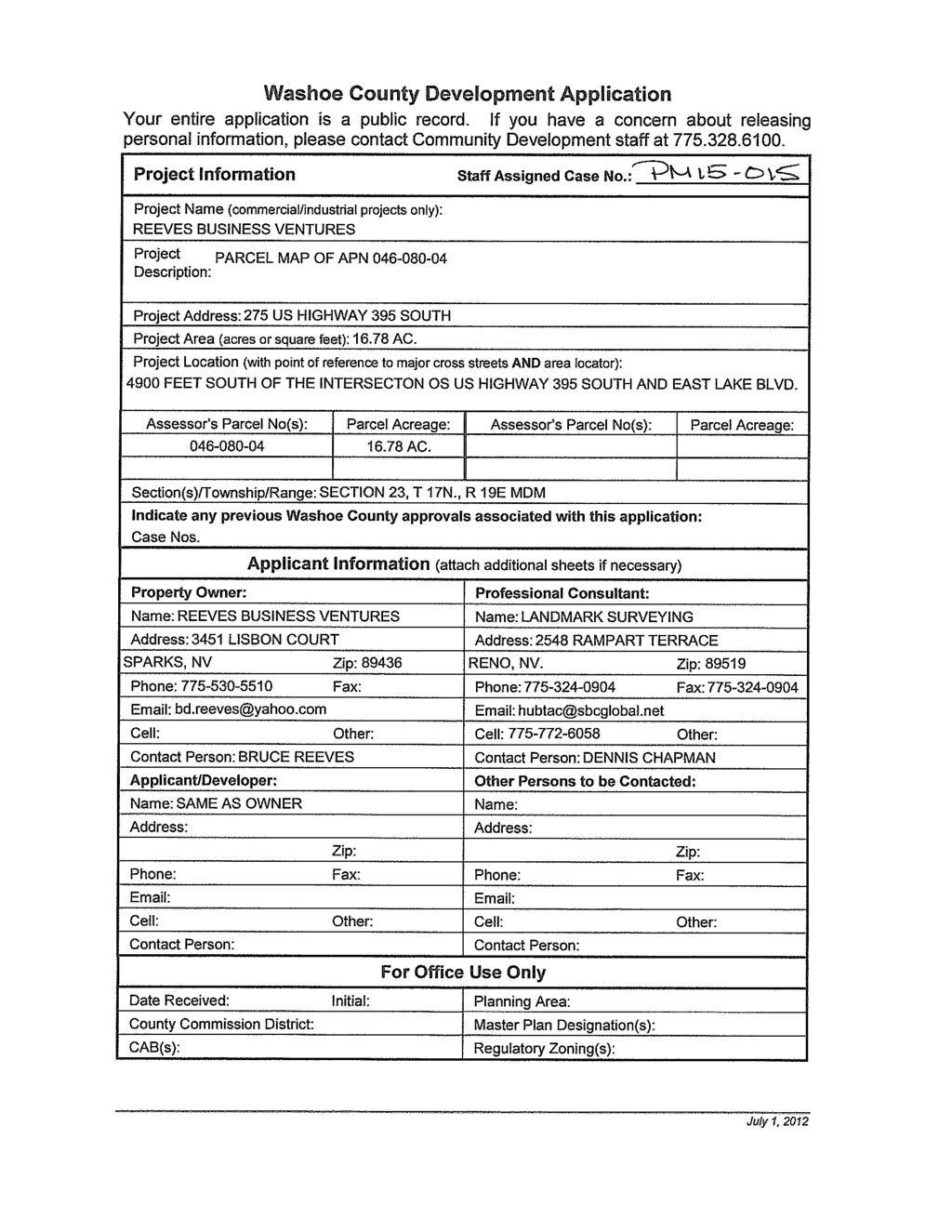
1 Parcel Map Review Committee Staff Report Meeting Date: October 8, 2015 Subject: Applicant: Agenda Item Number: Project Summary: Recommendation: Parcel Map Case Number Reeves Business Ventures 7D Divide a acre parcel into four parcels of varying sizes Approval with Conditions Prepared by: Eva M. Krause - AICP, Planner Washoe County Community Services Department Division of Planning and Development Phone: EKrause@washoecounty.us Description Parcel Map Case Number (Reeves Business Venture) Hearing, discussion, and possible action to approve the division of a acre parcel into a 3.23 acres parcel with a commercial building (parcel 1), a 7.92 acre vacant parcel (parcel 2), a 4.11 acre vacant lot (parcel 3) and a 1.52 acre lot with a single family residence (parcel 4). The property is located 2000 feet north of the intersection of Parker Ranch Road and US highway 395 South. Applicant: Reeves Business Venture Property Owner: Reeves Business Venture Location: 275 US Highway 395 South Assessor s Parcel Number: Parcel Size: acres Master Plan Category: Commercial (C) Regulatory Zone: General Commercial (GC) Area Plan: South Valleys Citizen Advisory Board: South Truckee Meadows/Washoe Valley Development Code: Authorized in Article 606, Parcel Map Commission District: 2 Commissioner Lucey Section/Township/Range: Section 23, T17N, R19E, MDM, Washoe County, NV Post Office Box 11130, Reno, NV E. Ninth St., Reno, NV Telephone: Fax: REEVES BUSINESS VENTURE
2 Washoe County Parcel Map Review Committee Staff Report Date: September 25, 2015 Staff Report Contents Parcel Map... 3 Vicinity Map... 4 Site Plan... 5 Tentative Parcel Map Evaluation... 6 Excerpt of South Valleys Development Suitability Map... 6 South Valleys Area Plan Modifiers... 6 Development Information... 7 Reviewing Agencies... 7 Staff Comment on Review Criteria... 8 Recommendation Motion Appeal Process Exhibits Contents Conditions of Approval... Exhibit A Health District Letter... Exhibit B Nevada Department of Transportation Letter... Exhibit C Parks and Open Space Memo... Exhibit D County Surveyor... Exhibit E Project Application... Exhibit F Parcel Map Case Number: Page 2 of 11 REEVES BUSINESS VENTURE
3 Washoe County Parcel Map Review Committee Staff Report Date: September 25, 2015 Parcel Map The purpose of a parcel map is to allow for the creation of subdivisions, merger and resubdivision of existing lots, and common-interest communities consisting of four or fewer parcels pursuant to Article 606, Parcel Maps, of the Washoe County Development Code. A tentative parcel map must be submitted to the Planning and Development Division for the purpose of review prior to or concurrent with the final parcel map. Every tentative parcel map must be prepared by a professional land surveyor. The parcel map process exists to establish reasonable standards of design and procedures for subdividing in order to further the orderly layout and use of land and insure proper legal descriptions and monumenting of subdivided land. Additionally, the process helps to safeguard the public health, safety and general welfare by establishing minimum standards of design and development for any land division platted in the unincorporated area of Washoe County. If the Washoe County Parcel Map Review Committee grants an approval of the tentative parcel map, that approval is subject to Conditions of Approval. Conditions of Approval are requirements that may need to be completed during different stages of the proposed project. Those stages are typically: Prior to recordation of a final map. Prior to obtaining a final inspection and/or a certificate of occupancy on a structure. Prior to the issuance of a business license or other permits/licenses. Some Conditions of Approval are referred to as Operational Conditions. These conditions must be continually complied with for the life of the project. Within 22 months from the date of approval of the tentative parcel map, the applicant must file a final parcel map along with any required supporting materials with the Planning and Development Division and the County Engineer showing that all conditions imposed by the Washoe County Parcel Map Review Committee have been met. Approval or conditional approval of a tentative parcel map imposes no obligation on the part of the Director of Planning and Development Division or the Board of County Commissioners to approve the final parcel map or to accept any public dedication shown on the tentative or final parcel map. Failure to submit a complete final parcel map and pay the required fees within the two year time period shall cease any further action on the map and shall render the tentative parcel map as expired. The Conditions of Approval for Tentative Parcel Map Case Number is attached to this staff report and will be included with the Action Order. Parcel Map Case Number: Page 3 of 11 REEVES BUSINESS VENTURE

4 Washoe County Parcel Map Review Committee Staff Report Date: September 25, 2015 Vicinity Map Parcel Map Case Number: Page 4 of 11 REEVES BUSINESS VENTURE
5 Washoe County Parcel Map Review Committee Staff Report Date: September 25, 2015 Site Plan Parcel Map Case Number: Page 5 of 11 REEVES BUSINESS VENTURE

6 Washoe County Parcel Map Review Committee Staff Report Date: September 25, 2015 Tentative Parcel Map Evaluation Land Use Designation: Maximum Lot Potential: 73 Number of Lots on Parcel Map: 4 Minimum Lot Size Required: Minimum Lot Size on Parcel Map: Minimum Lot Width Required: General Commercial 10,000 square feet 1.52 acres (66,232 sq. ft.) 75 feet Minimum Lot Width on Parcel Map: 170 feet The tentative parcel map meets all minimum requirements for the General Commercial regulatory zone. Development Suitability Constraints: The South Valleys Development Suitability Map, a part of the South Valleys Area Plan, identifies the northern half of the subject parcel as most suitable for development, and the southern half (closest to highway 395) as being located in the 100 year flood plain. Excerpt of South Valleys Development Suitability Map Hydrographic Basin: The subject parcel is within the Washoe Valley Hydrographic Basin. The subject parcel is outside the Truckee Meadows Service Area (TMSA). South Valleys Area Plan Modifiers Washoe Valley Hydrographic Basin. Dedication of sufficient certificated water rights from the Washoe Valley Hydrographic Basin, or imported water rights from an adjoining hydrographic basin when a parcel is split by the Washoe Valley Hydrographic Basin, or "will serve" letters Parcel Map Case Number: Page 6 of 11 REEVES BUSINESS VENTURE
7 Washoe County Parcel Map Review Committee Staff Report Date: September 25, 2015 when served by a water purveyor, shall be provided for all development in the Washoe Valley Hydrographic Basin, including maps of division into large parcels, parcel maps, and subdivision maps, and new civic, commercial and industrial use types. Development Information The subject parcel is developed with a single family house and a detached garage, as well as one commercial building. The required setbacks for General Commercial zoning are 10 feet from all property lines. The single family dwelling and commercial structure both meet the above-mentioned setbacks. The garage is considered a legal nonconforming structure because it does not met the required setback. The parcel map does not affect the nonconformance of the structure. Standard Development Code regulations do not allow residential uses in General Commercial zoning. Normally the subdivision of this property would result in a legal non-conforming use, but because the subject parcel is located in the South Valleys Area Plan, Old Washoe City Historic District, the use of the house may be reinstated through a special use permit. Appendix A, Table Two: Old Washoe City Historic Commercial District Character Management Area allows, with a special use permit, attached accessory dwellings as a live/work use. Therefore the existing residences may remain on the property, but may not be occupied as a residence until a special use permit is approved. Reviewing Agencies The following agencies received a copy of the project application for review and evaluationtruckee Meadows Fire Protection District Nevada Department of Transportation (NDOT) Regional Transportation Commission (RTC) Truckee Meadows Water Authority (TWMA) Washoe County Community Services Department o o o o Planning and Development Engineering and Capitol Projects Parks and Open Spaces Building and Safety Washoe County Health District o o Air Quality Environmental Health Services Seven out of the ten above listed agencies/departments provided comments and/or recommended conditions of approval in response to their evaluation of the project application. A summary of each agency s comments and/or recommended conditions of approval and their contact information is provided. The Conditions of Approval document is attached to this staff report and will be included with the Action Order if granted approval. Nevada Department of Transportation requires grading plans and drainage reports for work done in NDOT right-of-way. They also address driveway accesses, and the requirements for occupancy permits. Parcel Map Case Number: Page 7 of 11 REEVES BUSINESS VENTURE
8 Washoe County Parcel Map Review Committee Staff Report Date: September 25, 2015 Contact: Anita Lyday, Urban Traffic Engineer, , Truckee Meadows Water Authority stated property owner must provide water rights prior to development of the property. Contact: Levi Kleiber, Supervisor, Land and Mapping Services, , Planning and Development requires that the final map be in substantial compliance with all plans and documents submitted with the tentative parcel map. Approval of the parcel map does not grant approval for grading. Contact: Eva Krause, , County Surveyor requires the inclusion of FEMA floodplains and a drainage easement to the parcel map, the addition of a note to the map, a separate letter certifying roadway improvements, conditions on the access road, and other matters pertaining to the final map. Contact: Mike Gump, PLS, , mgump@washoecounty.us Environmental Health Division requires that water service be provided by a public water service and that existing wells be abandon. Also address the requirements for on-site sewage disposal systems. Contact: Chris Anderson, PE, , canderson@washoecounty.us Vector-Borne Disease addressed the requirements for the design of channel and ditch systems. Contact: J.L. Shaffer, , jshaffer@washoecounty.us Parks and Open Space discussed the need for grading plans and the use of certified weed free fill dirt and management practices to prevent the spread of noxious weeds. Contact: Dennis Troy, , dtroy@washoecounty.us Staff Comment on Review Criteria Section (i) of Article 606, Parcel Maps, within the Washoe County Development Code, requires that all of the following findings be made to the satisfaction of the Washoe County Parcel Map Review Committee before granting approval of the request. Staff has completed an analysis of the application and has determined that the proposal is in compliance with the required findings as follows. 1) General improvement considerations for all parcel maps including, but not limited to: a) Environmental and health laws and regulations concerning water and air pollution, the disposal of solid waste, facilities to supply water, community or public sewage disposal and, where applicable, individual systems for sewage disposal. Staff Comment: The Health Department requires that each parcel be attached to public water service and abandon exiting wells. On-site sewage disposal systems are required. b) The availability of water which meets applicable health standards and is sufficient for the reasonably foreseeable needs of the subdivision. Parcel Map Case Number: Page 8 of 11 REEVES BUSINESS VENTURE
9 Washoe County Parcel Map Review Committee Staff Report Date: September 25, 2015 Staff Comment: Prior to development of the property, the property owner must provide sufficient water rights to support the development to the Truckee Meadows Water Authority. c) The availability and accessibility of utilities. Staff Comment: Utilities are provided to the existing structures on parcels 1 and 3. Utility easements along the eastern property line of parcels 1, 2 and 4 provide accessibility to obtain utility services. d) The availability and accessibility of public services such as schools, police and fire protection, transportation, recreation and parks. Staff Comment: The subject parcels have a regulatory zone of General Commercial, therefore schools, parks and recreation services are not impacted. There are adequate police, fire and transportation services in the area. e) Conformity with the zoning ordinances and master plan. Staff Comment: The proposed parcel map conforms to General Commercial uses. The Old Washoe City Historic Commercial District Character Management Area Plan permits live/work uses by special use permit. f) General conformity with the governing body s master plan of streets and highways. Staff Comment: The proposed parcel map conforms to the streets and highways master plan. g) The effect of the proposed subdivision on existing public streets and the need for new streets or highways to serve the subdivision. Staff Comment: The proposed parcel map does not impact public streets or the need for new streets or highways. The opening of I-580 has significantly reduced traffic on Highway 395 South. h) Physical characteristics of the land such as floodplain, slope and soil. Staff Comment: Portions of Parcels 1, 2 and 3 are within the 100 year flood plain. New developments are required to conform to Washoe County standards for development in a flood plain. i) The recommendations and comments of those entities reviewing the tentative parcel map pursuant to NRS and , inclusive. Staff Comment: All recommendations and conditions submitted by the reviewing agencies are included in the Conditions of Approval (Exhibit A). j) The availability and accessibility of fire protection including, but not limited to, the availability and accessibility of water and services for the prevention and containment of fires including fires in wild lands. Staff Comment: Truckee Meadows Fire Protection District shall determine the availability and accessibility of fire protection at the time new development is proposed. The TMFPD shall require fire protection as required by the fire districts applicable codes. k) Community antenna television (CATV) conduit and pull wire. Staff Comment: Public utility easements are available. Parcel Map Case Number: Page 9 of 11 REEVES BUSINESS VENTURE
10 Washoe County Parcel Map Review Committee Staff Report Date: September 25, 2015 l) Recreation and trail easements. Recommendation Staff Comment: No recreational or trail easements are created, and none are impacted by the parcel map. Those agencies which reviewed the application, recommended conditions in support of approval of the tentative parcel map. Therefore, after a thorough analysis and review, Parcel Map Case Number is being recommended for approval with conditions. Staff offers the following motion for the Parcel Map Review Committee s consideration. Motion I move that, after giving reasoned consideration to the information contained within the staff report and the information received during the public meeting, that the Washoe County Parcel Map Review Committee approve Parcel Map Case Number for Reeves Business Venture which has determined that the following criteria is or will be adequately provided for pursuant to Washoe County Development Code, Section : General improvement considerations for all parcel maps including, but not limited to: a) Environmental and health laws and regulations concerning water and air pollution, the disposal of solid waste, facilities to supply water, community or public sewage disposal and, where applicable, individual systems for sewage disposal; b) The availability of water which meets applicable health standards and is sufficient for the reasonably foreseeable needs of the subdivision; c) The availability and accessibility of utilities; d) The availability and accessibility of public services such as schools, police and fire protection, transportation, recreation and parks; e) Conformity with the zoning ordinances and master plan; f) General conformity with the governing body s master plan of streets and highways; g) The effect of the proposed subdivision on existing public streets and the need for new streets or highways to serve the subdivision; h) Physical characteristics of the land such as floodplain, slope and soil; i) The recommendations and comments of those entities reviewing the tentative parcel map pursuant to NRS and , inclusive; j) The availability and accessibility of fire protection including, but not limited to, the availability and accessibility of water and services for the prevention and containment of fires including fires in wild lands; k) Community antenna television (CATV) conduit and pull wire; and l) Recreation and trail easements. Appeal Process Parcel Map Review Committee action will be effective 10 calendar days after the written decision is filed with the Secretary to the Parcel Map Review Committee, unless the action is appealed to the Washoe County Board of County Commissioners, in which case the outcome of the appeal shall be determined by the Washoe County Board of County Commissioners. Any Parcel Map Case Number: Page 10 of 11 REEVES BUSINESS VENTURE
11 Washoe County Parcel Map Review Committee Staff Report Date: September 25, 2015 appeal must be filed in writing with the Planning and Development Division within 10 calendar days after the written decision is filed with the Secretary to the Parcel Map Review Committee. xc: Property Owner/Applicant: Reeves Business Ventures Attn: Bruce Reeves 3451 Lisbon Court Sparks, NV Representatives: Landmark Surveying Attn: Dennis Chapman 2548 Rampart Terrace Reno, NV Parcel Map Case Number: Page 11 of 11 REEVES BUSINESS VENTURE

12 Conditions of Approval Parcel Map Case Number The tentative parcel map approved under Parcel Map Case Number shall be carried out in accordance with the Conditions of Approval granted by the Washoe County Parcel Map Review Committee on October 8, Conditions of Approval are requirements placed on a permit or development by each reviewing agency. These Conditions of Approval may require submittal of documents, applications, fees, inspections, amendments to plans, and more. These conditions do not relieve the applicant of the obligation to obtain any other approvals and licenses from relevant authorities required under any other act or to abide by all other generally applicable Codes, and neither these conditions nor the approval by the County of this project/use override or negate any other applicable restrictions on uses or development on the property. Unless otherwise specified, all conditions related to the approval of this tentative parcel map shall be met or financial assurance must be provided to satisfy the conditions of approval prior to the recordation of a final parcel map. The agency responsible for determining compliance with a specific condition shall determine whether the condition must be fully completed or whether the applicant shall be offered the option of providing financial assurance. All agreements, easements, or other documentation required by these conditions shall have a copy filed with the County Engineer and the Planning and Development Division. Compliance with the conditions of approval related to this tentative parcel map is the responsibility of the applicant, his/her successor in interest, and all owners, assignees, and occupants of the property and their successors in interest. Failure to comply with any of the conditions imposed in the approval of the tentative parcel map may result in the institution of revocation procedures. Washoe County reserves the right to review and revise the Conditions of Approval related to this tentative parcel map should it be determined that a subsequent license or permit issued by Washoe County violates the intent of this approval. For the purpose of conditions imposed by Washoe County, may is permissive and shall or must is mandatory. Conditions of Approval are usually complied with at different stages of the proposed project. Those stages are typically: Prior to recordation of a final map. Prior to obtaining a final inspection and/or a certificate of occupancy. Prior to the issuance of a business license or other permits/licenses. Some Conditions of Approval are referred to as Operational Conditions. These conditions must be continually complied with for the life of the project. Post Office Box 11130, Reno, NV E. Ninth St., Reno, NV Telephone: Fax: EXHIBIT A
13 Washoe County Parcel Map Review Committee Conditions of Approval The Washoe County Commission oversees many of the reviewing agencies/departments with the exception of the following agencies. The DISTRICT BOARD OF HEALTH, through the Washoe County Health District, has jurisdiction over all public health matters in the Health District. Any conditions set by the Health District must be appealed to the District Board of Health. The NEVADA DEPARTMENT OF TRANSPORTATION (NDOT) is directed and governed by its own board. Therefore, any conditions set by the Nevada Department of Transportation must be appealed to that Board. The TRUCKEE MEADOWS WATER ATHORITY (TMWA) is directed and governed by its own board. Therefore, any conditions set by the Truckee Meadows Water Authority must be appealed to that Board. FOLLOWING ARE CONDITIONS OF APPROVAL REQUIRED BY THE REVIEWING AGENCIES. EACH CONDITION MUST BE MET TO THE SATISFACTION OF THE ISSUING AGENCY. Washoe County Community Services Department 1. The following conditions are requirements of the Planning and Development Division, which shall be responsible for determining compliance with these conditions. Contact: Eva Krause, AICP, Planner, , a. The final map shall be in substantial compliance with all plans and documents submitted as part of this tentative parcel map application, and with any amendments imposed by the Parcel Map Review Committee. All documentation necessary to satisfy the conditions noted below shall accompany the final map when submitted to the County Engineer and the Planning and Development Division. b. The applicant shall comply with all the conditions of approval and shall submit a final map for signature by the Director of the Planning and Development Division within 22 months from the date of approval by the Parcel Map Review Committee. Each agency responsible for imposing conditions may determine whether its conditions must be fully completed or whether the applicant shall be offered the option of providing financial assurances as a means of assuring compliance. c. The final map shall contain the following jurat: DIRECTOR OF PLANNING AND DEVELOPMENT CERTIFICATE THE FINAL PARCEL MAP CASE NO. MEETS ALL APPLICABLE STATUTES, ORDINANCES AND CODE PROVISIONS; IS IN SUBSTANTIAL CONFORMANCE WITH THE TENTATIVE MAP AND ITS CONDITIONS, WHICH ARE INCORPORATED HEREIN BY THIS REFERENCE, AND THOSE CONDITIONS HAVE BEEN SATISFIED FOR RECORDATION OF THIS MAP. THE OFFER(S) OF DEDICATION IS (ARE) REJECTED AT THIS TIME, BUT WILL REMAIN OPEN IN ACCORDANCE WITH NEVADA REVISED STATUTES CHAPTER 278. THIS FINAL MAP IS APPROVED AND ACCEPTED THIS DAY OF, 20, BY THE DIRECTOR OF PLANNING AND Parcel Map Case Number. Page 2 of 5 EXHIBIT A
14 Washoe County Parcel Map Review Committee Conditions of Approval DEVELOPMENT OF WASHOE COUNTY, NEVADA, IN ACCORDANCE WITH NEVADA REVISED STATUTES THROUGH WILLIAM WHITNEY, DIRECTOR, PLANNING AND DEVELOPMENT DIVISION d. Any regulations, procedures, and conditions adopted by the Washoe County Health District must be met prior to recordation of a final map. e. The applicant shall provide verification to the Planning and Development Division that all conditions from the Truckee Meadows Fire Protection District have been satisfied. f. The applicant has indicated that the proposed improvements will exceed the major grading thresholds; therefore a special use grading permit is required. g. The approval for this tentative parcel map does not include improvements for driveways to building pads. Grading for access to building pads shall be included as part of the special use permit application. h. The existing residence shall not be used as a residence unless and until a Special Use Permit is issued for a commercial use with an attached accessory dwelling (Live/Work) as permitted by the Old Washoe City Commercial Historic District CMA. 2. The following conditions are requirements of the Parks and Open Space Program, which shall be responsible for determining compliance with these conditions. Contact: Dennis Troy, , dtroy@washoecounty.us a. The project identifies that 48,750 cubic yards of dirt will be disturbed on the on the site but fill and export amounts are not identified, nor does it mention if it is a balanced site. Please include the following notes on future plan sets: i. All fill dirt imported as part of the project is required to be certified weed free. ii. Best management practices will be used to prevent the spread of noxious and invasive weeds during construction activities. At minimum, the highlighted portion in the attached document provided will be included on future construction plans and specifications. 3. The following conditions are requirements of the Engineering and Capital Projects Division, which shall be responsible for determining compliance with these conditions. Contact: Mike Gump, PLS, , mgump@washoecounty.us a. There appears to be a power pole and business sign within the access easement off of highway 395. b. Add a graphic border around the proposed division. c. Remove structures from the map. d. An NDOT driveway permit is required. e. The applicant shall submit a letter from a PLS certifying that the roadway improvements are within the documented access and do not exceed a 14% gradient f. Add the FEMA floodplains to the map. Parcel Map Case Number. Page 3 of 5 EXHIBIT A
15 Washoe County Parcel Map Review Committee Conditions of Approval g. Add the following note to the map: Any structures within a FEMA flood zone must comply with the Washoe County Development Code Article 416. h. Add a drainage easement for surface drainage. i. Remove debris from the proposed division. j. Any access way shall be upgraded to a gravel road that will allow emergency vehicle travel, issuance of a building permit and take drainage into consideration. Submit plans for review and approval. k. Comply with the conditions of the Washoe County technical check for this map. l. Add a Security Interest Holder s Certificate to the map if applicable. Washoe County Health District 4. The following conditions are requirements of Environment Health Services Division, which shall be responsible for determining compliance with these conditions. Contact: J.L. Shaffer, , jshaffer@washoecounty.us Approval by Vector Borne Disease Program of this Division is subject to the following conditions: a. If a road side ditch system is proposed the Health District will require 4-6 inch cobble rock in the flow line of the channel and ditches to reduce the transport of sediment (Vector ). b. Prior to the sign off of the building plans the above detail designs are required on the plans and a scheduled compliance inspection with the Vector-Borne Diseases Program is required for the above condition(s). Contact: Chris Anderson, PE, , canderson@washoecounty.us Prior to approval of a Final Parcel Map, consent by Engineering of this Division is dependent to the following conditions being performed and submitted for review and approval prior to Final Parcel Map approval: c. The notes on the Final Parcel Map must be revised to include the exclusive provision of water service from public water for each parcel created. d. Any existing wells must be abandoned and a Well Abandonment Permit must be applied for prior to connection of any improvements to the public water system. e. Each proposed parcel must be assessed for the suitability of onsite sewage disposal systems (OSDS). Test trench permit(s) must be obtained from this Division to determine the suitability of the proposed Parcels for OSDS. f. The test trenches shall be plotted on the proposed Parcel Map. g. Any commercial building on proposed Parcel 1 shall be served by an approved commercial OSDS system to be obtained from the Nevada Bureau of Water Pollution Control. The Final Parcel Map shall incorporate this in a note on the Final Parcel Map. 1 District Board of Health Regulations Governing the Prevention of Vector-Borne Diseases. Parcel Map Case Number. Page 4 of 5 EXHIBIT A
16 Washoe County Parcel Map Review Committee Conditions of Approval Nevada Department of Transportation 5. The following conditions are requirements of the Nevada Department of Transportation, which shall be responsible for determining compliance with these conditions. Contact: Anita Lyday, , a. Prior to any grading adjacent to the Nevada Department of Transportation right-of-way, a Drainage Report, including a grading plan, and a Drainage Form must be submitted to the Permits office. Please contact the Permits Office at for more information. b. The Nevada Department of Transportation requires an occupancy permit for any work performed within the State s right-of-way. Please contact the Permits Office at for more information regarding the occupancy permit. c. Existing approaches are personal and not transferable with the sale of the property. All driveway accesses to the state highway system will be required to comply with the NDOT access management guidelines current at the time of the application. d. The state defers to municipal government for land use development decisions. Public involvement for development related improvements within the NDOT right-of-way should be considered during the municipal land use development public involvement process. Significant public improvements within the NDOT right-of-way, developed after the public involvement process, may require additional public involvement. It is the responsibility of the permit applicant to perform such additional public involvement. We would encourage such public involvement to be part of the municipal land use development process. Truckee Meadows Water Authority 6. The following conditions are requirements of the Truckee Meadows Water Authority (TMWA), which shall be responsible for determining compliance with these conditions. Contact: Levi Kleiber, , LKleiber@tmwa.com a. The property owner must provide water rights to the Truckee Meadows Water Authority sufficient to support the proposed development prior to the finalization of any building permits on the property. *** End of Conditions *** Parcel Map Case Number. Page 5 of 5 EXHIBIT A
17 EXHIBIT B
18 EXHIBIT B
19 EXHIBIT C
20 EXHIBIT D


21 Washoe County COMMUNITY SERVICES DEPARTMENT Engineering and Capital Projects INTEROFFICE MEMORANDUM DATE: September 29, 2015 PARCEL MAP REVIEW TO: FROM: Department of Community Services Mike Gump, PLS, Engineering Division SUBJECT: Parcel Map for: Eva Krause Parcel Map Case No.: APN: Review Date: 09/24/2015 Existing Zoning/Land Use Designation: The Engineering Division has reviewed the subject parcel map and the following conditions must be successfully completed prior to final approval of this application by the Engineering Division. 1. There appears to be a power pole and business sign within the access easement off of highway Add a graphic border around the proposed division. 3. Remove structures from the map. 4. An NDOT driveway permit is required. 5. The applicant shall submit a letter from a PLS certifying that the roadway improvements are within the documented access and do not exceed a 14% gradient 6. Add the FEMA floodplains to the map. 7. Add the following note to the map: Any structures within a FEMA flood zone must comply with the Washoe County Development Code Article Add a drainage easement for surface drainage. 9. Remove debris from the proposed division. 10. Any access way shall be upgraded to a gravel road that will allow emergency vehicle travel, issuance of a building permit and take drainage into consideration. Submit plans for review and approval. 11. Comply with the conditions of the Washoe County technical check for this map. 12. Add a Security Interest Holder s Certificate to the map if applicable E. 9 TH Street P.O. Box 11130, Reno, Nevada Phone (775) Fax (775) EXHIBIT E
22 EXHIBIT F
23 EXHIBIT F
24 EXHIBIT F
25 EXHIBIT F
26 EXHIBIT F
27 EXHIBIT F
28 EXHIBIT F
29 EXHIBIT F
Parcel Map Review Committee Staff Report Meeting Date: October 13, 2016
 Subject: Applicant: Agenda Item Number: Project Summary: Recommendation: Parcel Map Review Committee Staff Report Meeting Date: October 13, 2016 Parcel Map Case Number Spanish Springs Associates Ltd. Ptsp.
Parcel Map Review Committee Staff Report Meeting Date: May 12, 2016
 Subject: Applicant: Agenda Item Number: Project Summary: Recommendation: Parcel Map Review Committee Staff Report Meeting Date: May 12, 2016 Tentative Parcel Map Case Number TL Mt. Rose Estates, LP 7C
Parcel Map Review Committee Staff Report Meeting Date: March 12, 2015
 Subject: Applicant(s): Agenda Item Number: Parcel Map Review Committee Staff Report Meeting Date: March 12, 2015 Parcel Map Case Number William and Maryanne Paganetti 7B Project Summary: Dividing a 14.2
Parcel Map Review Committee Staff Report
 Parcel Map Review Committee Staff Report Meeting Date: October 11, 2018 Agenda Item: 7A TENTATIVE PARCEL MAP CASE NUMBER: (Larkins) BRIEF SUMMARY OF REQUEST: Request to divide one parcel of ±1.084-acres
Parcel Map Review Committee Staff Report Meeting Date: March 12, 2015
 Parcel Map Review Committee Staff Report Meeting Date: March 12, 2015 Subject: Applicant(s): Agenda Item Number: Project Summary: Recommendation: Prepared by: Parcel Map Case Number Eric and Rebecca Swanson
Administrative Permit Staff Report Meeting Date: February 2, 2017
 Administrative Permit Staff Report Meeting Date: February 2, 2017 Subject: Applicant: Agenda Item Number: Summary: Recommendation: Administrative Permit Case Number WADMIN16-0001 Carlson and Associates
DRAFT. 1. Determination of Quorum Eric Young called the meeting to order at 1:31 p.m. The following members and staff were present:
 WASHOE COUNTY PARCEL MAP REVIEW COMMITTEE Meeting Minutes Parcel Map Review Committee Members Thursday, December 8, 2016 1:30 p.m. James Barnes, Planning Commission James English, Health District Tim Simpson,
Parcel Map Review Committee Staff Report Meeting Date: April 13, 2017
 Parcel Map Review Committee Staff Report Meeting Date: April 13, 2017 Subject: Applicant: Agenda Item Number: Project Summary: Recommendation: Prepared by: Parcel Map Case Number Christy Corporation 7A
Board of Adjustment Staff Report Meeting Date: June 1, 2017
 Board of Adjustment Staff Report Meeting Date: June 1, 2017 Subject: Applicant: Agenda Item Number: Summary: Recommendation: Prepared by: Phone: E-Mail: Administrative Permit Case Number Powning Family
Parcel Map Review Committee Staff Report Meeting Date: June 8, 2017
 Parcel Map Review Committee Staff Report Meeting Date: June 8, 2017 Subject: Applicant/Owner: Agenda Item Number: Project Summary: Recommendation: Parcel Map Case Number Dyke and Beth Kauffmann 7C Divide
Board of Adjustment Staff Report Meeting Date: April 4, 2013
 Board of Adjustment Staff Report Meeting Date: April 4, 2013 Subject: Applicant(s): Agenda Item No. Project Summary: Recommendation: Prepared by: Variance Case No: VA13-001 Gary R. Taylor on behalf of
Detached Accessory Dwelling Administrative Review Staff Report Date: August 26, 2014
 Detached Accessory Dwelling Administrative Review Staff Report Subject: Detached Accessory Dwelling Administrative Review Case No: DADAR14-04 Applicant(s): Nick Gibson Summary: To establish a Detached
Planning Commission Staff Report Meeting Date: February 2, 2016
 Planning Commission Staff Report Meeting Date: February 2, 2016 Subject: Applicant(s): Agenda Item Number: Summary: Recommendation: Abandonment Case Number Gary and Rachel Bullock 9B To allow the abandonment
Planning Commission Staff Report Meeting Date: September 6, 2016
 Planning Commission Staff Report Meeting Date: September 6, 2016 Subject: Applicant(s): Agenda Item Number: Project Summary: Recommendation: Tentative Subdivision Map Case Number: Spanish Springs Associates,
Board of Adjustment Staff Report Meeting Date: February 5, 2015
 Board of Adjustment Staff Report Meeting Date: February 5, 2015 Subject: Applicants: Agenda Item Number Project Summary: Recommendation: Variance Case Number: Lawrence and Judith Romiti 7A Reduce the front
LYON COUNTY COMMUNITY DEVELOPMENT DEPARTMENT
 LYON COUNTY COMMUNITY DEVELOPMENT DEPARTMENT B UILDING D EVELOPMENT E NGINEERING P LANNING 27 S. MAIN S TREET Y ERINGTON, NEVADA 89447 (775) 463-6591 F AX: (775) 463-5305 34 LAKES B OULEVARD D AYTON, NEVADA
LYON COUNTY TITLE 15 LAND USE AND DEVELOPMENT CODE LAND DIVISION REGULATIONS CHAPTERS October 19, 2017 Ordinance Draft DRAFT
 DRAFT LYON COUNTY TITLE 15 LAND USE AND DEVELOPMENT CODE LAND DIVISION REGULATIONS CHAPTERS 15.600 15.607 October 19, 2017 Ordinance Draft This page left blank intentionally DRAFT DRAFT Lyon County Contents
Memorandum: October 13, 2008 REVISED To: Trowbridge Township Planning Commission From: P. Hudson, AICP Re: Suggested New Ordinance
 1 Memorandum: October 13, 2008 REVISED 2-11-09 To: Trowbridge Township Planning Commission From: P. Hudson, AICP Re: Suggested New Ordinance Because of changes in both the Michigan Planning Enabling Act
Tentative Map Application Review Procedures
 FOR REFERENCE ONLY This page is not part of the application. Tentative Map Application Review Procedures The tentative map process in Churchill County is designed to provide a mechanism in order to divide
Group Sewer Only** 80 Ft Frontage* 20,000 Sq. Ft. (.46 acre) Minimum** 120 Ft Frontage* 20,000 Sq. Ft. (.46acre) Minimum** 150 Ft Frontage*
 Minimum** 120 Ft Frontage* 20,000 Sq. Ft. (.46acre) Minimum** 150 Ft Frontage*") Residential Lots Minimum Chart The minimum lot size of any minor subdivision where there is no public sewers shall be as shown below or as required by township zoning and/or the Tuscarawas General Health
Residential Lots Minimum Chart The minimum lot size of any minor subdivision where there is no public sewers shall be as shown below or as required by township zoning and/or the Tuscarawas General Health
APPLICATION FOR 555 Washington Street Tentative Map Red Bluff, CA Subdivision Map (530) ext Parcel Map.
 ext Parcel Map.") City of Red Bluff Community Development Department Application No. APPLICATION FOR 555 Washington Street Tentative Map Red Bluff, CA 96080 Subdivision Map (530) 527-2605 ext. 3059 Parcel Map Applicant
City of Red Bluff Community Development Department Application No. APPLICATION FOR 555 Washington Street Tentative Map Red Bluff, CA 96080 Subdivision Map (530) 527-2605 ext. 3059 Parcel Map Applicant
Conditional Use Permit / Standard Subdivision Application
 Conditional Use Permit / Standard Subdivision Application Name of Proposed Subdivision: Total Area (Acres) Is Proposed Subdivision to be built in phases? Number of Lots If yes, how many phases? Applicant/Owner
Planning Commission Staff Report Meeting Date: October 6, 2015
 Planning Commission Staff Report Meeting Date: October 6, 2015 Subject: Applicant(s): Agenda Item Number: Summary: Recommendation: Prepared by: Extension for Tentative Subdivision Map Case Number TL Mt.
NYE COUNTY, NV PAHRUMP REGIONAL PLANNING COMMISSION REGULAR MEETING JANUARY 11, 2017
 CASE DESCRIPTION(S): LOCATION: APN NUMBER(S): AP# 045-021-59 NYE COUNTY, NV PAHRUMP REGIONAL PLANNING COMMISSION REGULAR MEETING JANUARY 11, 2017 a. For Possible Action TM-2016-00004: Tentative Map application
CONDOMINIUM REGULATIONS
 ARTICLE 37 CONDOMINIUM REGULATIONS SECTION 37.01. Purpose The purpose of this Article is to regulate projects that divide real property under a contractual arrangement known as a condominium. New and conversion
1.0 REQUEST. SANTA BARBARA COUNTY ZONING ADMINISTRATOR Coastal Zone Staff Report for Vincent New Single-Family Dwelling & Septic System
 SANTA BARBARA COUNTY ZONING ADMINISTRATOR Coastal Zone Staff Report for Vincent New Single-Family Dwelling & Septic System Hearing Date: February 26, 2007 Supervisorial District: First Staff Report Date:
ELK RAPIDS TOWNSHIP ANTRIM COUNTY, MICHIGAN ORDINANCE NO
 ELK RAPIDS TOWNSHIP ANTRIM COUNTY, MICHIGAN ORDINANCE NO. 3-2011 AN ORDINANCE TO REPLACE THE SUBDIVISION CONTROL ORDINANCE WITH A NEW SUBDIVISION DEVELOPMENT ORDINANCE, IN ACCORD WITH THE LAND DIVISION
MUNICIPAL DISTRICT OF ROCKY VIEW NO. 44 ELBOW VALLEY WEST DIRECT CONTROL DISTRICT BYLAW C
 This document has been consolidated for convenience only. A current listing of any and all amendments can be obtained from the Municpal District Office Bylaw No. Date of Approval Amendment Type Bylaw C-6042-2005
LAND USE APPLICATION
 Lincoln County Department of Planning & Development 210 SW 2nd Street, Newport, OR 97365 Phone (541) 265-4192 Fax (541) 265-6945 LAND USE APPLICATION TO BE COMPLETED BY STAFF Conditional Use Non-Conforming
Reference Document Do Not Copy
 Parcel Map, Division Into Large Parcels, and Reversion to Acreage Map Review Procedures The parcel map process in Churchill County is designed to provide a mechanism in order to divide a parcel or parcels
Town of Prairie du Sac Sauk County, WI. Land Division Ordinance 07-3
 Town of Prairie du Sac Sauk County, WI Land Division Ordinance 07-3 1.01 DISCLAIMER (1) Multiple Jurisdictions. All persons reviewing the provisions of this Ordinance should be aware that the Town of Prairie
APPLICATION PROCEDURE
 ANTRIM PLANNING BOARD P. O. Box 517 Antrim, New Hampshire 03440 Phone: 603-588-6785 FAX: 603-588-2969 APPLICATION FORM AND CHECKLIST FOR MINOR OR MAJOR SITE PLAN REVIEW File Date Received By APPLICATION
Project File #: SF Project Name: Jackson Ranch Filing No. 4 Parcel Nos.: , and
 COMMISSIONERS: DARRYL GLENN (PRESIDENT) MARK WALLER (PRESIDENT PRO TEMPORE) STAN VANDERWERF LONGINOS GONZALEZ PEGGY LITTLETON PLANNING AND COMMUNITY DEVELOPMENT DEPARTMENT CRAIG DOSSEY, EXECUTIVE DIRECTOR
Condominium Unit Requirements.
 ARTICLE 19 CONDOMINIUM REGULATIONS Section 19.01 Purpose. The purpose of this Article is to regulate projects that divide real property under a contractual arrangement known as a condominium. New and conversion
CHAPTER 14: DRIVEWAYS, TOWN HIGHWAYS, AND PRIVATE ROADS
 CHAPTER 14: DRIVEWAYS, TOWN HIGHWAYS, AND PRIVATE ROADS TABLE OF CONTENTS CHAPTER 14: PRIVATE DRIVEWAYS, TOWN HIGHWAYS AND PRIVATE ROADS 14-1 14.0100 AUTHORITY... 14-1 14.0200 TITLE... 14-1 14.0300 REGULATION
MINOR SUBDIVISION COMMITTEE COUNTY OF MONTEREY, STATE OF CALIFORNIA
 MINOR SUBDIVISION COMMITTEE COUNTY OF MONTEREY, STATE OF CALIFORNIA RESOLUTION NO. 05010 In the matter the application GIANNINI FAMILY LIMITED PARTNERSHIP (PLN040273) APN# 113-071-006-000 FINDINGS & DECISION
VERDI COMMUNITY MEETING. May 21, 2016
 VERDI COMMUNITY MEETING May 21, 2016 Community Workshop Overview Land Development Presentation Topical Breakout Groups Water & Wastewater Public Safety Transportation Schools Why Do Communities Plan? Make
COUNTY OF SANTA BARBARA PLANNING AND DEVELOPMENT MEMORANDUM. Santa Barbara County Planning Commission
 COUNTY OF SANTA BARBARA PLANNING AND DEVELOPMENT MEMORANDUM TO: FROM: HEARING DATE: RE: Santa Barbara County Planning Commission Florence Trotter-Cadena, Planner III North County Development Review October
MEMORANDUM. TERESA McCLISH, COMMUNITY DEVELOPMENT DIRECTOR
 MEMORANDUM TO: FROM: BY: PLANNING COMMISSION TERESA McCLISH, COMMUNITY DEVELOPMENT DIRECTOR MATTHEW DOWNING, ASSISTANT PLANNER SUBJECT: CONSIDERATION OF TENTATIVE PARCEL MAP CASE NO. 14-002; SUBDIVISION
ARTICLE SINGLE FAMILY SITE CONDOMINIUM DEVELOPMENT STANDARDS
 ARTICLE 28.00 SINGLE FAMILY SITE CONDOMINIUM DEVELOPMENT STANDARDS Section 28.01 PURPOSE The purpose of this Article is to recognize that conventional single family developments, traditionally developed
SUBDIVISION APPLICATION CHECKLIST SKETCH PLAN PRELIMINARY PLAT FINAL PLAT
 RECEIVED STAMP SUBDIVISION APPLICATION CHECKLIST SKETCH PLAN PRELIMINARY PLAT FINAL PLAT A checklist of background information and submission requirements for processing of a sketch plan, preliminary plat
INTERLOCAL AGREEMENT PERMITTING CONSTRUCTION OF SOUTHEAST CONNECTOR ON THE TRUCKEE MEADOWS WATER RECLAMATION FACILITY
 INTERLOCAL AGREEMENT PERMITTING CONSTRUCTION OF SOUTHEAST CONNECTOR ON THE TRUCKEE MEADOWS WATER RECLAMATION FACILITY This Agreement Permitting Construction of SouthEast Connector on the Truckee Meadows
River Rock Estates Sketch Plan, a proposed major subdivision in S24, T35N R2W NMPM on County Rd 119 (PLN18-336)
") MEMORANDUM Archuleta County Development Services Planning Department 1122 HWY 84 P. O. Box 1507 Pagosa Springs, Colorado 81147 970-264-1390 Fax 970-264-3338 TO: Archuleta County Planning Commission FROM:
MEMORANDUM Archuleta County Development Services Planning Department 1122 HWY 84 P. O. Box 1507 Pagosa Springs, Colorado 81147 970-264-1390 Fax 970-264-3338 TO: Archuleta County Planning Commission FROM:
Community Services Department BOUNDARY LINE ADJUSTMENT APPLICATION
 Community Services Department Planning and Building BOUNDARY LINE ADJUSTMENT APPLICATION Community Services Department Planning and Building 1001 E. Ninth St., Bldg. A Reno, NV 89520 Telephone: 775.328.6100
APPLICATION SUBMITTAL REQUIREMENTS FOR Tentative Parcel or Subdivision Maps
 CITY OF EL CERRITO Community Development Department Planning and Building Division 10890 San Pablo Avenue, El Cerrito, CA 94530 (510) 215-4330 FA (510) 233-5401 planning@ci.el-cerrito.ca.us APPLICATION
NYE COUNTY, NV PAHRUMP REGIONAL PLANNING COMMISSION REGULAR MEETING DECEMBER 14, 2016
 CASE DESCRIPTION(S): LOCATION: APN NUMBER(S): AP# 045-021-21 LEGAL DESCRIPTION(S): PROPERTY OWNER(S): APPLICANT(S): AGENT(S): NYE COUNTY, NV PAHRUMP REGIONAL PLANNING COMMISSION REGULAR MEETING DECEMBER
ARTICLE 6 PRELIMINARY PLAT
 ARTICLE 6 PRELIMINARY PLAT SECTION: 30-06-01: Preliminary Plat 30-06-02: Information Required for Preliminary Plat 30-06-03: Determination of Requirement for Environmental Review Documents 30-06-04: Additional
ARTICLE 13 CONDOMINIUM REGULATIONS
 ARTICLE 13 CONDOMINIUM REGULATIONS Section 13.01 Purpose. The purpose of this Article is to regulate projects that divide real property under a contractual arrangement known as a condominium. New and conversion
204 Minor Subdivision & Large Lot Division
 204 Minor Subdivision & Large Lot Division 204.01 Purpose and Intent 204.05 General Procedures 204.10 Large Lot Division 204.02 Comprehensive Land Use 204.06 Submittal Requirements Plan Policies 204.07
All items include discussion and possible action to approve, modify, deny, or continue unless marked otherwise.
 Jim Hindle Chairman Jim Collins Planning Commissioner Larry Prater Planning Commissioner Summer Pellett- Planning Commissioner Storey County Planning Commission Meeting Agenda Thursday November 1, 2018
Chapter 100 Planned Unit Development in Corvallis Urban Fringe
 100.100 Scope and Purpose. Chapter 100 Planned Unit Development in Corvallis Urban Fringe (1) All applications for land divisions in the Urban Residential (UR) and Flood Plain Agriculture (FPA) zones within
This Ordinance is adopted under the authority and provisions of the General Statutes of North Carolina, Article 6, Chapter 153A 121.
 Section 74, Regulations Governing Manufactured Home Parks 1. Purpose The purpose of these regulations to be known and cited as the Madison County Manufactured Home Park Ordinance is to regulate and guide
MUNICIPALITY OF THE DISTRICT OF CLARE SUBDIVISION BY-LAW
 MUNICIPALITY OF THE DISTRICT OF CLARE SUBDIVISION BY-LAW 1 Table of Contents PART 1 - TITLE... 4 PART 2 - INTERPRETATION... 4 PART 3 - DEFINITIONS... 4 PART 4 - PROCEDURE FOR APPROVAL OF PLANS OR INSTRUMENTS
TENTATIVE MAP APPLICATION GUIDE (BCC 20-1)( 20-2 to )( to 20-91)( to )
( 20-2 to )( to 20-91)( to )") Butte County Department of Development Services PERMIT CENTER 7 County Center Drive, Oroville, CA 95965 Planning Division Phone 530.552.3701 Fax 530.538.7785 Email dsplanning@buttecounty.net FORM NO PLG-05
Butte County Department of Development Services PERMIT CENTER 7 County Center Drive, Oroville, CA 95965 Planning Division Phone 530.552.3701 Fax 530.538.7785 Email dsplanning@buttecounty.net FORM NO PLG-05
This is a conditional use permit request to establish a commercial wind energy conversion system.
 Public Works 600 Scott Boulevard South Hutchinson, Kansas 67505 620-694-2976 Road & Bridge Planning & Zoning Noxious Weed Utilities Date: March 28, 2019 To: From: Reno County Planning Commission Russ Ewy,
COUNTY OF SACRAMENTO CALIFORNIA ZONING ADMINISTRATOR REPORT
 COUNTY OF SACRAMENTO CALIFORNIA ZONING ADMINISTRATOR REPORT For the Agenda of: May 4, 2016 To: From: Subject: Supervisorial District(s): Zoning Administrator Department of Community Development PLNP2015-00222.
Community Services Department REGULATORY ZONE AMENDMENT WITH SPECIFIC PLAN APPLICATION
 Community Services Department Planning and Development REGULATORY ZONE AMENDMENT WITH SPECIFIC PLAN APPLICATION Community Services Department Planning and Development 1001 E Ninth St., Bldg A. Reno, NV
Community Services Department TENTATIVE PARCEL MAP PARCEL MAP WAIVER APPLICATION
 Community Services Department Planning and Building TENTATIVE PARCEL MAP (see page 5) PARCEL MAP WAIVER (see page 15) APPLICATION Community Services Department Planning and Building 1001 E. Ninth St.,
The purpose of this Chapter is to establish rules, regulations, standards and procedures for approval of subdivisions of land to promote and ensure:
 CHAPTER 7 SUBDIVISION SECTION 7.1 PURPOSE The purpose of this Chapter is to establish rules, regulations, standards and procedures for approval of subdivisions of land to promote and ensure: A. Conformity
HOW TO APPLY FOR A USE PERMIT
 HOW TO APPLY FOR A USE PERMIT MENDOCINO COUNTY PLANNING AND BUILDING SERVICES What is the purpose of a use permit? Throughout the County, people use their properties in many different ways. They build
SISKIYOU COUNTY PLANNING COMMISSION STAFF REPORT March 21, 2018
 SISKIYOU COUNTY PLANNING COMMISSION STAFF REPORT March 21, 2018 NEW BUSINESS - AGENDA ITEM No. 2: JOANNE RICHARDSON TENTATIVE PARCEL MAP (TPM-17-04) APPLICANT: PROPERTY OWNER: PROJECT SUMMARY: GENERAL
201 General Provisions
 201 General Provisions 201.01 Title 201.09 Amendments 201.02 Purpose and Intent 201.10 Public Purpose 201.03 Authority 201.11 Variances and Appeals 201.04 Jurisdiction 201.12 Nonconformances 201.05 Enactment
MONTEREY COUNTY ZONING ADMINISTRATOR
 MONTEREY COUNTY PLANNING AND BUILDING INSPECTION DEPARTMENT COASTAL OFFICE, 2620 1 ST AVENUE, MARINA, CA 93933 (831) 883-7500, main line / (831) 384-3261, facsimile SCOTT HENNESSY, DIRECTOR MONTEREY COUNTY
-MENDOCINO COUNTY PLANNING AND BUILDING SERVICES- DIVISION OF LAND REGULATIONS TITLE 17
 ARTICLE VI -- GENERAL REGULATIONS AND PROVISIONS Sec. 17-50. Sec. 17-51 General Plan. Sec. 17-52 Lot and Block Design and Configuration. Sec. 17-53 Lot Access. Sec. 17-54 Private Roads. Sec. 17-55 Water
SECTION 4: PRELIMINARY PLAT
 SECTION 4: PRELIMINARY PLAT After the completion of the sketch plan process, if submitted, the owner or developer shall file with the City an application for preliminary plat. The preliminary plat stage
Preliminary Subdivision Application (Minor) (Three (3) lots or less)
 (Three (3) lots or less)") Gunnison City Offices www.gunnisoncity.org 38 West Center Gunnison, Utah 84634 (435) 528 7969 Date of Application: Preliminary Subdivision Application (Minor) (Three (3) lots or less) APPLICANT INFORMATION
Gunnison City Offices www.gunnisoncity.org 38 West Center Gunnison, Utah 84634 (435) 528 7969 Date of Application: Preliminary Subdivision Application (Minor) (Three (3) lots or less) APPLICANT INFORMATION
Lake County Planning, Building and Development Department
 SUBMISSION CHECKLIST FOR SUBDIVISION FINAL PLAT Lake County Planning, Building and Development Department 500 W. Winchester Rd. Unit 101 Libertyville, Illinois 60048-1331 Telephone (847) 377-2600 E-mail:
WEBSTER TOWNSHIP LAND DIVISION ORDINANCE. Summary Table of Amendments
 WEBSTER TOWNSHIP LAND DIVISION ORDINANCE Ordinance No. 2012 02 As Adopted 04-17-12 Summary Table of Amendments Adoption Date Affected Sections Summary October 10, 3 Added definition of Township Engineer
CHAPTER 3 PRELIMINARY PLAT
 10-3-1 10-3-3 SECTION: CHAPTER 3 PRELIMINARY PLAT 10-3-1: Consultation 10-3-2: Filing 10-3-3: Requirements 10-3-4: Approval 10-3-5: Time Limitation 10-3-6: Grading Limitation 10-3-1: CONSULTATION: Each
Planning and Zoning Commission STAFF REPORT
 TO: FROM: Planning and Zoning Commission STAFF REPORT CASA GRANDE PLANNING AND ZONING COMMISSION James Gagliardi, AICP, City Planner MEETING DATE: September 1, 2016 REQUEST AGENDA # Request by Marshall
DEPARTMENT OF FISH AND WILDLIFE ENVIRONMENTAL FILING FEES (Fish and Game Code 711.4)
") PARCEL MAP PROCESS DEPARTMENT OF PLANNING AND BUILDING SERVICES 707 Nevada Street, Suite 5 Susanville, CA 96130-3912 (530) 251-8269 (530) 251-8373 (fax) www.co.lassen.ca.us A subdivision is any division
PARCEL MAP PROCESS DEPARTMENT OF PLANNING AND BUILDING SERVICES 707 Nevada Street, Suite 5 Susanville, CA 96130-3912 (530) 251-8269 (530) 251-8373 (fax) www.co.lassen.ca.us A subdivision is any division
UPPER MOUNT BETHEL TOWNSHIP NORTHAMPTON COUNTY, PENNSYLVANIA
 UPPER MOUNT BETHEL TOWNSHIP NORTHAMPTON COUNTY, PENNSYLVANIA JOINDER DEED / LOT CONSOLIDATION TOWNSHIP REVIEW PROCESS When accepting proposed Joinder Deeds / Lot Consolidations, review the Joinder Deed
ARTICLE 1 GENERAL PROVISIONS
 ARTICLE 1 GENERAL PROVISIONS SECTION 100 TITLE This Ordinance shall be known and cited as the "Rice Township Subdivision and Land Development Ordinance." SECTION 101 AUTHORITY Rice Township is empowered
13-2 SUBDIVISION PLANS AND PLATS REQUIRED EXCEPTIONS Subdivision Plats Required To be Recorded
 ARTICLE XIII SUBDIVISIONS 13-1 INTENT AND PURPOSE 13-1-1 Intent: It is the intent of the County Commission through the adoption of this Article to more fully avail itself of the power granted under 17-27-601
FINAL DRAFT 12/1/16, Rev. to 7/18/17
 FINAL DRAFT 12/1/16, Rev. to 7/18/17 (As Adopted 8/8/17 Effective 9/1/17) SHELTON PLANNING AND ZONING COMMISSION Proposed Amendments to Zoning Regulations I. Amend Section 23 PERMITTED USES by inserting
COUNTY OF EL DORADO DEVELOPMENT SERVICES PLANNING COMMISSION STAFF REPORT TENTATIVE MAP
 COUNTY OF EL DORADO DEVELOPMENT SERVICES PLANNING COMMISSION STAFF REPORT Agenda of: June 27, 2013 Item No.: 9.a Staff: Mel Pabalinas TENTATIVE MAP FILE NUMBER: APPLICANT: REQUEST: LOCATION: TM10-1501/West
ARTICLE 5 MINOR SUBDIVISION/LAND DEVELOPMENT
 ARTICLE 5 MINOR SUBDIVISION/LAND DEVELOPMENT SECTION 501 ONLY FINAL PLAN REQUIRED The classification of a proposed subdivision as a "Minor Subdivision" shall only require the submission, review and approval
Guide to Combined Preliminary and Final Plats
 Guide to Combined Preliminary and Final Plats Introduction The Douglas County is committed to providing open, transparent application processes to the public. This Guide is provided to assist anyone interested
TENTATIVE MAP INFORMATION SHEET
 TENTATIVE MAP INFORMATION SHEET GENERAL INFORMATION This information sheet explains how your Tentative Map application will be processed, what fees you must pay, and what plans you must submit. If you
DEPARTMENT OF PLANNING SERVICES 1555 N 17 th Ave Greeley CO Phone (970) Fax (970)
 Fax (970)") DEPARTMENT OF PLANNING SERVICES 1555 N 17 th Ave Greeley CO 80631 Phone (970) 400-6100 Fax (970) 304-6498 SITE SPECIFIC DEVELOPMENT PLAN USE BY SPECIAL REVIEW PROCEDURAL GUIDE SOLID WASTE DISPOSAL SITES
DEPARTMENT OF PLANNING SERVICES 1555 N 17 th Ave Greeley CO 80631 Phone (970) 400-6100 Fax (970) 304-6498 SITE SPECIFIC DEVELOPMENT PLAN USE BY SPECIAL REVIEW PROCEDURAL GUIDE SOLID WASTE DISPOSAL SITES
CERTIFICATION OF THE APPROVAL OF WATER AND SEWERAGE SYSTEMS
 ARTICLE 9 FORMS AND CHECK LISTS 9.100 On preliminary layout & final subdivision plat CERTIFICATION OF THE APPROVAL OF WATER AND SEWERAGE SYSTEMS I hereby certify that the (...type: private or pubic...)
SUBDIVISION REGULATIONS OF THE CITY OF DERBY, KANSAS
 SUBDIVISION REGULATIONS OF THE CITY OF DERBY, KANSAS ARTICLE 1. TITLE, PURPOSE, AUTHORITY, JURISDICTION, APPLICABILITY AND EXEMPTIONS 100 TITLE. These regulations shall be known and may be cited as the
STATE OF MICHIGAN COUNTY OF MARQUETTE, TOWNSHIP OF NEGAUNEE LAND DIVISION, SUBDIVISION AND CONDOMINIUM ORDINANCE
 STATE OF MICHIGAN COUNTY OF MARQUETTE, TOWNSHIP OF NEGAUNEE LAND DIVISION, SUBDIVISION AND CONDOMINIUM ORDINANCE Adopted: August 8 th, 2008 Effective: August 28 th, 2008 Sec.100. Title ARTICLE I GENERAL
A.3. ARTICLE 7 PLAN REQUIREMENTS FOR MINOR SUBDIVISION AND/OR LAND DEVELOPMENT
 700. 701.A.3. ARTICLE 7 PLAN REQUIREMENTS FOR MINOR SUBDIVISION AND/OR LAND DEVELOPMENT SECTION 700 PURPOSE The purpose of this Article is to set forth a streamlined set of Plan Requirements for minor
PROVINCIAL SUBDIVISION REGULATIONS. Municipal Government Act
 PROVINCIAL SUBDIVISION REGULATIONS Made under Section 270 of the Municipal Government Act Chapter 18 of the Statutes of Nova Scotia, 1998 Service Nova Scotia and Municipal Relations April 1, 1999 (with
Residential Major Subdivision Review Checklist
 Residential Major Subdivision Review Checklist Plan Submittal Requirements: 2 full sets of stamped plans Electric submittal - all plans contained in a single PDF 3 full sets if commercial kitchen or dining
Planning Commission Hearing Date: 2/21/2017 Board of County Commissioners Hearing Date: 3/8/2017
 COMMISSIONERS: DARRYL GLENN (PRESIDENT) MARK WALLER (PRESIDENT PRO TEMPORE) STAN VANDERWERF LONGINOS GONZALEZ PEGGY LITTLETON PLANNING AND COMMUNITY DEVELOPMENT DEPARTMENT CRAIG DOSSEY, EXECUTIVE DIRECTOR
REQUIREMENTS FOR RESIDENTIAL PLAN REVIEW New Constructions, additions and remodel
 Department of Development P. O. Box 628 (985) 898-2574 or (985) 646-4166 Fax: (985) 898-2785 or (985) 646-4174 permits@stpgov.org Revised 03/03/16 Completed Permit Application REQUIREMENTS FOR RESIDENTIAL
ARTICLE VI. SPECIAL EXCEPTION REGULATIONS
 ARTICLE VI. SPECIAL EXCEPTION REGULATIONS SECTION 601. GENERAL DESCRIPTION Special exceptions are deemed to be permitted uses in their respective districts, subject to the satisfaction of the requirements
TOWN OF WATERVILLE VALLEY NEW HAMPSHIRE SITE PLAN REVIEW REGULATIONS
 TOWN OF WATERVILLE VALLEY NEW HAMPSHIRE Effective date March 17, 1981 Revised March 16, 1982 Revised March 13, 1986 Revised March 10, 1987 Revised March 14, 2013 Revised March 8, 2016 TOWN OF WATERVILLE
This is a New Findings of Adequacy for a Recorded Plat (Plat Book 179, Page 131) LAND USE Vacant Effective Plan: Pompano Beach
 LAND USE Vacant Effective Plan: Pompano Beach") Page 1 of 11 Board of County Commissioners, Broward County, Florida Environmental Protection and Growth Management Department Planning and Development Management Division DEVELOPMENT REVIEW REPORT PROJECT
Page 1 of 11 Board of County Commissioners, Broward County, Florida Environmental Protection and Growth Management Department Planning and Development Management Division DEVELOPMENT REVIEW REPORT PROJECT
6.1 SCHEDULE OF AREA, FRONTAGE, YARD AND HEIGHT REQUIREMENTS
 SECTION 6.0 6.1 SCHEDULE OF AREA, FRONTAGE, YARD AND HEIGHT REQUIREMENTS Minimum Minimum Minimum Minimum Minimum Maximum Maximum Lot Lot Front Side Rear Height Lot District Area Front Yard Yard Yard Coverage
LARAMIE COUNTY PLANNING & DEVELOPMENT DEPARTMENT
 LARAMIE COUNTY PLANNING & DEVELOPMENT DEPARTMENT Planning Building MEMORANDUM TO: FROM: Laramie County Planning Commission Bryan Nicholas, Associate Planner DATE: April 11, 2019 TITLE: Review and action
TOWNSHIP OF DOYLESTOWN APPLICATION FOR REVIEW OF SUBDIVISION OR LAND DEVELOPMENT PROPOSAL. Please PRINT; all information MUST be filled out completely
 TOWNSHIP OF DOYLESTOWN APPLICATION FOR REVIEW OF SUBDIVISION OR LAND DEVELOPMENT PROPOSAL Please PRINT; all information MUST be filled out completely Date: Name of Subdivision or Land Development: Location:
Planning and Development TENTATIVE SUBDIVISION MAP APPLICATION
 Community Services Department Planning and Development TENTATIVE SUBDIVISION MAP APPLICATION Community Services Department Planning and Development 1001 E Ninth St., Bldg A. Reno, NV 89520 Telephone: 775.328.3600
Legal Description Part of the Western Half of the Eastern Half of the Northwest Quarter of Section 30, Le Ray Township
 Owner and Applicant s 20448 State Highway 83 Mankato, MN 56001 Request and Location Request for review and approval of a Conditional Use Permit to allow an Elder Care Residential Unit to be constructed
PRELMINARY PLAT CHECKLIST
 PRELMINARY PLAT CHECKLIST A. All preliminary plat submitted for approval shall be prepared by a Registered Professional Land Surveyor. B. Preliminary plats must be drawn to a scale of XXX with such accuracy
Preliminary Subdivision Application (Major) (Four (4) lots or more)
 (Four (4) lots or more)") Gunnison City Offices www.gunnisoncity.org 38 West Center Gunnison, Utah 84634 (435) 528 7969 Date of Application: Preliminary Subdivision Application (Major) (Four (4) lots or more) APPLICANT INFORMATION
Gunnison City Offices www.gunnisoncity.org 38 West Center Gunnison, Utah 84634 (435) 528 7969 Date of Application: Preliminary Subdivision Application (Major) (Four (4) lots or more) APPLICANT INFORMATION
Residential Minor Subdivision Review Checklist
 Residential Minor Subdivision Review Checklist Plan Submittal Requirements: 2 full sets of stamped plans Electric submittal - all plans contained in a single PDF 3 full sets if commercial kitchen or dining
CONCEPT PLAN APPLICATION Meeting with Staff Commercial Projects
 COMMUNITY DEVELOPMENT City of South Salt Lake Community Development Department 220 E. Morris Avenue South Salt Lake City, Utah 84115 Phone (801) 483-6011 Fax (801) 483-6060 CONCEPT PLAN APPLICATION Meeting