PLANNING COMMISSION AGENDA CITY COUNCIL CHAMBERS JULY 11, 2006 THE PLANNING COMMISSION S VISION OF ITS ROLE IN THE COMMUNITY
|
|
|
- Gavin Gilmore
- 5 years ago
- Views:
Transcription
1 PLANNING COMMISSION AGENDA CITY COUNCIL CHAMBERS JULY 11, 2006 THE PLANNING COMMISSION S VISION OF ITS ROLE IN THE COMMUNITY The Planning Commission sees its role as the preparation and implementation of the Comprehensive Plan through which the Commission seeks to promote orderly growth, preserve the quality of Coeur d Alene, protect the environment, promote economic prosperity and foster the safety of its residents. 5:30 P.M. CALL TO ORDER: ROLL CALL: Bruning, Bowlby,George, Jordan, Rasor, Messina, Souza APPROVAL OF MINUTES: June 13, 2006 PUBLIC COMMENTS: COMMISSION COMMENTS: STAFF COMMENTS: ADMINISTRATIVE ITEMS: 1. Applicant: Joe Lamphiear Location: 1021 Crestline Request: Proposed 3-lot preliminary plat Rock Haven Estates SHORT PLAT, (SS Applicant: D.A.C. Inc. Location: 3107 N. 2 nd Street Request: Proposed 17-unit Condominium plat Autumn Crest Condominiums SHORT PLAT, (SS-16-06) 3. Applicant: George Ciccone Location: 830 N. 23 rd Request: Proposed 2-lot preliminary plat Creekside Meadows SHORT PLAT, (SS-17-06) PUBLIC HEARINGS: 1. Applicant: Brian and Brenda Goetz Location: 3932 N. Schreiber Way Request: A proposed Professional Office special use permit in the LM (light manufacturing) zone QUASI-JUDICIAL, (SP-9-06)
2 2. Applicant: Shefoot Investments, LLC Location: In the vicinity of 19 th Street and Nettleton Gulch Road adjacent to Greystone Subdivision Request: A. A proposed annexation for a 3.5 acre parcel from County Agricultural Suburban to City R-3 (Residential at 3 units/acre) QUASI-JUDICIAL, (A-4-06) B. A proposed 5-lot preliminary plat Shefoot QUASI-JUDICIAL, (S-8-06) 3 Applicant: Charles Morgan and Associates Location: S.W. corner of Marie Avenue and Julia Street Request: A proposed R-34 Residential Density special use permit in the C-17(Commercial at 17 units/acre) zoning district QUASI-JUDICIAL, (SP-10-06) 4. Applicant: Riverstone West, LLC Location: 2800 Seltice Way Request: A proposed 26-lot preliminary plat Riverstone West Phase II QUASI-JUDICIAL, (S-1-05.m) 5. Applicant: City of Coeur d Alene Request: Updating the 2003 Bikeways Plan LEGISLATIVE, (0-2-06) ADJOURNMENT/CONTINUATION: Motion by, seconded by, to continue meeting to,, at p.m.; motion carried unanimously. Motion by,seconded by, to adjourn meeting; motion carried unanimously. *The City of Coeur d Alene will make reasonable accommodations for anyone attending this meeting who requires special assistance for hearing, physical or other impairments. Please contact Shana Stuhlmiller at (208) at least 24 hours in advance of the meeting date and time.
3
4 PLANNING COMMISSION MINUTES JUNE 13, 2006 CITY COUNCIL CHAMBERS COMMISSIONERS PRESENT John Bruning, Chairman Heather Bowlby Melinda George Brad Jordan Tom Messina Scott Rasor Mary Souza STAFF MEMBERS PRESENT John Stamsos, Associate Planner Shana Stuhlmiller, Public Hearing Assistant Warren Wilson, Deputy City Attorney Gordon Dobler, Engineering Services Director COMMISSIONERS ABSENT Mary Souza CALL TO ORDER Chairman Bruning called the meeting to order at 5:30 p.m. APPROVAL OF MINUTES: Motion by Rasor, seconded by Bowlby, to approve the minutes of the Planning Commission Meetings held on April 19, 2002, May 9, 2006 and May 15, Motion approved COMMISSION COMMENTS: None. STAFF COMMENTS: Associate Planner Stamsos announced the up-coming meetings for the month of June and announced that Building Heart nominations are due to be selected. He noted that since the Commission has a workshop scheduled with the Bike/Ped Committee on Tuesday, June 27 th, that if the Commission would like any items added to that agenda, him their ideas by next week. The Planning Commission decided that Wednesday June 28 th will be the next Comp-plan meeting. Associate Planner Stamsos announced that Mayor Bloem appointed a new Planning Commissioner, Melinda George. Deputy City Attorney Wilson updated the Commission on a bill recently passed by the State legislature dealing with local land use planning. He explained that this bill states that if a Commissioner has a conflict with a hearing that they should be excused from the hearing and be allowed to testify at that hearing. He explained that this bill is vague and until there is further clarification would advise that any Commissioner that has a conflict to consult with him. PLANNING COMMISSION MINUTES: June 13, 2006 PAGE 1
5 PUBLIC COMMENTS: There were none. ADMINISTRATIVE ITEMS: 1. Applicant: E & R Properties, LLC Location: Lot 3, Block 1, Lake Forest, 9 th Addition Request: Proposed 4-lot preliminary Plat Marblewood Addition SHORTPLAT (SS-11-06) Engineering Services Director Dobler presented the staff report and then asked if the Commission had any questions. The Commission did not have any questions for staff. Motion by Rasor, seconded by Messina, to approve Item SS Motion approved. 2. Applicant: Courtyard Homes Development, INC. Location: Lot 8, Block 2 of Bellerive Subdivision Request: Proposed 14-unit Condominium Plat Courtyard Homes SHORTPLAT (SS-12-06) Engineering Services Director Dobler presented the staff report and then asked if the Commission had any questions. The Commission did not have any questions for staff. Motion by Rasor, seconded by Bowlby, to approve Item SS Motion approved. 3. Applicant: Bill Thompson Location: 4397 Bourban Drive Request: Proposed 5-unit Condominium Plat Royal Crown Condominiums SHORTPLAT (SS-13-06) Engineering Services Director Dobler presented the staff report and then asked if the Commission had any questions. The Commission did not have any questions for staff. Motion by Rasor, seconded by Bowlby, to approve Item SS Motion approved. 4. Applicant: Mike Tilford Request: Modification to Riverstone West phasing plan INTERPRETATION, (I-2-06) Associate Planner Stamsos presented the staff report and then asked if the Commission had any questions. PLANNING COMMISSION MINUTES: June 13, 2006 PAGE 2
6 Commissioner Rasor inquired if the lots proposed on the plat are intended to be for single-family homes. Associate Planner Stamsos answered that the applicant is present and would be able to address that question. Mike Tilford, Applicant representative, explained the proposed modifications to the Commission. He commented that in this proposal a number of the lots have been reduced to allow the designer more flexibility, and that by eliminating the lots located between Riverstone Drive and the pond will provide a more traditional lot configurations. He added at the request of staff, two rectangular lots located to the south of the pond, next to the parking lot, have been consolidated for a future public park. He then asked if the Commission had any questions. Commissioner Bowlby questioned if the lots planned in phase 2 on the preliminary plat will include any residential housing. Mr. Tilford answered that, in the future, those lots will be a combination of a mixed-use development that will incorporate the original vision approved with the original PUD. Commissioner Rasor commented that when the original plat was submitted it showed various boxes naming a specific use intended for each lot. Mr. Tilford explained that the market is changing and that the vision for those lots has changed. He commented that the purpose for naming those lots in the past was intended to not be defining, but only to give a flavor of how the development could look in the future. Commissioner Bowlby commented that she feels that these modifications are not a significant change from the original plat presented in the past. Commissioner Jordan concurred and feels that the intended use has not changed. Commissioner Messina concurred. Motion by Jordan, seconded by Rasor, to approve Item I-2-06, that these modifications are not a significant change from the original plat. Motion approved. 5. Applicant: Copper Basin Construction, Inc. Request: Interpretation of Mill River Final Development Plan INTERPRETATION (I-3-06) Chairman Bruning commented if any Commissioner had a conflict with this item. Commissioner Rasor commented that he had a conflict with this item and was excused from the hearing. Associate Planner Stamsos presented the staff report and asked if the Commission had any questions. Commissioner Jordan questioned what is the difference between this request and what was previously approved with the original PUD. Associate Planner Stamsos explained that the layout approved with PUD-4-04 was for illustrative purposes only and that recently this parcel has been sold. He continued that the applicant feels that the original layout should not be binding and the restrictions removed, similar to what was approved for the mult-family parcel to the immediate west of the subject parcel. PLANNING COMMISSION MINUTES: June 13, 2006 PAGE 3
7 Steve White, Applicant representative, explained that he recently purchased the property and is asking for removal of the restrictions approved with PUD He explained that the original owners, Neighborhood Inc. did not intend for the drawings submitted at the original hearing to be binding, and only to be use for illustrative purposes. He added that this is a great piece of property with a lot of potential if these restrictions are removed. He added that the goals and the intent of the project are still intact from what was presented in the past by Neighborhood Inc. Cliff Mort, Neighborhood Inc., commented that when the original PUD was submitted the drawings submitted for that parcel were only intended to be conceptional showing the Commission the vision of the project. He commented that he is confident that Copper Basin will do great things with this parcel and still maintain the vision intended with this project. Chairman Bruning commented that the underlying zoning is already established, so the issue is the additional units that will be added to the parcel. Commissioner Jordan concurred and commented there are not a lot of restrictions to be enforced with commercial zoning. Commissioner Bowlby commented that she feels this is not a significant change from what was submitted with the original PUD. Motion by Jordan, seconded by Messina, to approve Item I-3-06, and that this request is not a significant change. Motion approved. PUBLIC HEARINGS 1. Applicant: Coeur d Alene Congregation of Jehovah s Witnesses, Inc. Location: 486 W. Fuller Court Request: A proposed Religious Assembly special use permit in the MH-8 zoning district. QUASI-JUDICIAL (SP-7-06) Associate Planner Stamsos presented the staff report, gave the mailing tally as 0 in favor, 2 opposed, 1 neutral, and answered questions from the Commission. Commissioner Jordan inquired that in the packet there are copies of the elevations of the building and questioned why these were submitted. Associate Planner Stamsos answered that those drawings were submitted so the Commission could get an idea how the building will look. Matt Gibb, Applicant representative, 1931 N. 6 th, Coeur d Alene, commented that he recently attended a project review with staff, and in that meeting, staff recommended changes to the site plan that were not incorporated to the copies given to the Commission tonight. He explained that the set backs and width of approaches have changed because staff felt that traffic in this area is a concern, so additional egress and ingress have been added to the property that will cut down on the congestion in that area. He commented that the church holds two services on Sunday, with an estimate of 40 to 45 cars generated by the combined services. He added that lighting provided to the site would be low-level site specific with the lighting fixtures turned towards the ground to protect the surrounding neighborhood from any light trespass. He then asked if the Commission had any questions. Chairman Bruning commented that five mobile homes are currently on the property, and questioned if the applicant has made arrangements for these folks to be relocated. PLANNING COMMISSION MINUTES: June 13, 2006 PAGE 4
8 Mr. Gibb answered that recently one of the mobile homes had been relocated, and that the owner has made arrangements for the others to be relocated to another area in the City. Ron Cope, 3864 N. Miners Loop, Coeur d Alene, commented that he owns the property west of the applicant s parcel and questioned if this is the same process he will have to go through to construct a church with a capacity of 300 people. Chairman Bruning answered that Mr. Cope s property is the same zoning and that he would also need to go through the public hearing process for approval. Bill Bryant, 3735 Fruitland Lane, Coeur d Alene, commented that he owns the storage units next to the applicant s parcel and feels that traffic is a concern. He commented that he is not against religion but traffic on this road is bad. Zach Lennon, 879 Warm Springs Avenue, Post Falls, explained the various activities that the church has during the week and would estimate that those activities would generate between 40 to 50 cars per meeting. He commented that the meetings that church conducts are very peaceful; quiet and will not are not intended to disturb the neighborhood. Public testimony closed. Commissioner Bowlby commented that she feels that this project is a compatible use with the area and that with the addition of more entries will help ease traffic to the neighborhood. Chairman Bruning concurred and feels that this is a good use for this parcel. Motion by Rasor, seconded by Bowlby, to approve Item SP Motion approved. ROLL CALL: Commissioner Bowlby Commissioner Jordan Commissioner Messina Commissioner Rasor Voted Aye Voted Aye Voted Aye Voted Aye Motion to approve carried by a 4 to 0 vote. 2. Applicant: Ken Sand Location: 720 E. Poplar Avenue Request: A proposed Community Education special use permit in the R-12 (Residential at 12 units/acre) zoning district QUASI-JUDICIAL (SP-8-06) Associate Planner Stamsos presented the staff report, gave the mailing tally as, 2 in favor, 2 opposed, and 0 neutral, and answered questions from the Commission. The Commission did not have any questions for staff. Ken Sand, Applicant representative, 111 Homestead Avenue, Coeur d Alene, commented that both his children attended the Litehouse Academy that was established in He added that this school has been a benefit to the community and the children who have benefited from the academy in the past. He commented that he feels the school is compatible with the area that also includes North Idaho College and Project Coeur d Alene that is within close proximity of this building. He commented that the goal of the PLANNING COMMISSION MINUTES: June 13, 2006 PAGE 5
9 school is to have no more than 16 students per classroom and provide a good Christian school to the community. He noted that the school is located on a dead end road and that the property is fully fenced. Commissioner Jordan commented that with an increase to the enrollment from the school, it might create a disturbance to the neighborhood. Mr. Sand answered that the property behind the school is fenced with a vegetative buffer along the fence that acts as a buffer between the school and the neighborhood. He added that the school operates Monday through Thursday and explained that with only 75 students enrolled, it should not have a major impact to traffic in the area. Keith Clemans, 4127 Maple Leaf Road, Coeur d Alene, commented that he is the school board president and that his children currently attend the school. He added that this school has been a great benefit to the community in the past. He commented that he works for the City as a building inspector and will testify that this school meets all the codes for any safety issues. He added that recently he did is own traffic count for the school and found that there was 23 cars in the morning when parents were dropping off kids and in the afternoon 31 cars when kids were being picked up. David Konigsberg, 1716 N. 7 th Street, commented that the school abuts his property and is concerned with kids peering into his yard and violating his privacy. He added that traffic is a concern especially at 7:00 a.m. with 30 cars going to drop off their kids for school. He suggested that the City might want to consider either the load is decreased or reduce the speed limit on that street. Commissioner Bowlby commented that she feels that this school will benefit the neighborhood by decreasing activity especially on Saturdays and Sundays when the school is closed. She suggested that maybe staff could recommend traffic calming or signage placed at the school to remind people to slow down on this street. Mr. Konigsberg concurred that this would help tremendously with traffic. Chairman Bruning questioned if this school would qualify as a school zone which would require a sign be posted at the school. Associate Planner Stamsos answered that City Engineer, Gordon Dobler, would be the one to address that question to. REBUTTAL: Ken Sand, commented that he feels that this school is compatible with the surrounding neighborhood and that with the various ages of the children who attend the school recesses will be staggered so kids are not outside all at once. Public testimony is closed. DISCUSSION: Commissioner Bowlby questioned if staff could see if this would quality as a school zone designation Motion by Jordan, seconded by Rasor, to approve Item SP Motion approved. PLANNING COMMISSION MINUTES: June 13, 2006 PAGE 6
10 ROLL CALL: Commissioner Bowlby Commissioner Jordan Commissioner Messina Commissioner Rasor Voted Aye Voted Aye Voted Aye Voted Aye Motion to approve carried by a 4 to 0 vote. 3. Applicant: Roxana Rams-Dunteman Location: 110 E. Homestead Request: A proposed zone change from R-12 (Residential at 12 units/acre) to C-17L (Commercial Limited at 17 units/acre) QUASI-JUDICIAL (ZC-5-06) Associate Planner Stamsos presented the staff report, gave the mailing tally as 2 in favor, 2 opposed, and 2 neutral, and answered questions from the Commission. Commissioner Rasor questioned if this parcel would be considered a mid-block issue and if the old rule would apply. Associate Planner Stamsos explained that the mid-block rule applies if the Commission determines a parcel such as this one is appropriate for commercial zoning, and if so, how far should it encroach into the adjoining residential area. Commissioner Jordan commented that he feels that this parcel fronts on a side street and would disagree that the mid-block rule should be the determining factor for approval. Roxana Rams-Dunteman, Applicant, 2205 White Tail, Coeur d Alene, commented that she started her business, Coeur d Alive, LLC, as a service that would help women in the community by providing a women s health and welfare referral database. She explained that the residence will be used primarily for the business and that the rest of building will be leased out. She commented that there will not be a lot of traffic generated from this business since it a data-base service, and has plans to use the backyard as a sanctuary where women will be able to relax and garden. She added that this is a unique lot with a lot of potential, if approved. Commissioner Bowlby commented that she feels that the concept is great and will benefit many women in the community and explained that her concern is that once the zone is changed it is permanent. Ms. Dunteman commented that she has driven around Coeur d Alene searching to find a spot for her business and that when she located this parcel felt it was unique a piece of property not surrounded by a lot of homes. Commissioner Bowlby commented that there is a lot of established older homes in the area and has heard numerous remarks that the City has enough commercial. She added that she cannot ignore the mid-block rule and questioned if a homeowner s occupation would work for this project. Associate Planner Stamsos explained that since the applicant is leasing out the basement and will not live in the residence it would not qualify for a Home Occupation certificate. PLANNING COMMISSION MINUTES: June 13, 2006 PAGE 7
11 Ms. Dunteman commented that this is a web-based business and how the underlying component reason for starting this business was that when moving to the area she did not know where anything was in the area. She added that this would be a great resource to help disadvantaged women in the area find help. Gerald Martin, 206 Homestead Avenue, commented that he has lived in his house for 38 years does not plan on moving, feels that this is an established neighborhood and is opposed to the request. Rob Worth, 822 N. 18 TH Coeur d Alene, commented that the business sounds like something the community needs but is concerned that if the business leaves who might move into the building. REBUTTAL: Ms. Dunteman expressed that she is sensitive to the neighborhood but feels that this will be an asset to the neighborhood, if approved. She commented that this parcel is surrounded by various commercial properties but also feels that she does not want to stir up the neighborhood. Public testimony closed. DISCUSSION: Commissioner Jordan commented that our community is blessed because of people who want to make a difference like the applicant. He added that this is a tough decision to make but a decision needs to be made regarding land use and feels that if the zone is changed and the applicant decides to move, what kind of use might occupy the property. Commissioner Bowlby commented that she is hesitant to grant the zone change and still feels that this is a good candidate for the mid-block rule. Motion by Rasor, seconded by Messina, to reopen testimony for the applicant. Motion approved. Ms. Dunteman commented that she feels this does not qualify for the mid block rule since the property is surrounded by a commercial businesses and how this business will be an asset to the community. Commissioner Jordan commented that he feels that this does not qualify for a traditional midblock issue but is concerned once the zone is changed it is permanent. He feels that there are a lot of established homes in the area and if the applicant leaves, the zoning stays, with potential for a business to move in that is not as desirable. Commissioner Messina commented that if the zone change is granted and the applicant moves the neighborhood will be in jeopardy and feels that this is a lot to risk. Ms. Dunteman commented that the City has had a lot of changes in the past, and feels that this is a good area for her business. She added that the current zone, which is an R-12, allows mult-family and feels that it could be more detrimental to the neighborhood than what she is proposing. Commissioner Bowlby commented that this zone change is premature for the area at this time and feels that there are many older established homes in this area that would be jeopardized by this approval. Chairman Bruning commented that the use the applicant has presented would be something the community could use, but concurs with Commissioner Bowlby, that once the zone change is granted it is permanent. PLANNING COMMISSION MINUTES: June 13, 2006 PAGE 8
12 Motion by Bowlby, seconded by Jordan, to deny Item ZC Motion approved. ROLL CALL: Commissioner Bowlby Commissioner Jordan Commissioner Messina Commissioner Rasor Voted Aye Voted Aye Voted Aye Voted Aye Motion to approve carried by a 4 to 0 vote. ADJOURNMENT: Motion by Rasor, seconded by Jordan, to adjourn the meeting. Motion approved. The meeting was adjourned at 9:30 p.m. Respectfully submitted by John Stamsos, Associate Planner Prepared by Shana Stuhlmiller, Public Hearing Assistant PLANNING COMMISSION MINUTES: June 13, 2006 PAGE 9
13
14 TO: Planning Commission FROM: Christopher H. Bates, Project Manager DATE: July 11, 2006 SUBJECT: SS-15-06, Rock Haven Estates DECISION POINT Approve or deny the applicant's request for a 3 lot residential development. GENERAL INFORMATION 1. Applicant: Joe Lamphiear 1021 Crestline Drive Coeur d Alene, ID Request: Approval of a three (3) lot residential development. Lot 1: Lot 2: Lot 3: 30,937 square feet 37,486 square feet 33,966 square feet 3. Location: Between Crestline Drive & Stanley Hill Road, directly east of US-90. PERFORMANCE ANALYSIS 1. Zoning: Existing zoning for the subject property is R-3 which is intended as a residential area that allows single family dwelling units at three (3) units per gross acre. Minimum lot size is 11,500 square feet. 2. Land Use: The subject property has an existing single family dwelling situated on proposed Lot 1, while proposed lots 2 and 3 are vacant. Lots 2 and 3 are hillside lots and will be required to meet all of the development requirements of the Hillside Ordinance. Infrastructure: Utilities, Streets, & Storm Water Facilities Utilities: Sewer & Water The existing structure situated on Lot 1 currently receives City sewer and water services. The two remaining lots have access to the sanitary sewer adjoining US- 90 or in Crestline Drive, and, water service from Stanley Hill Road (Water Dept. requirement). Service laterals will be required to be extended onto the subject property and to the proposed lots prior to final plat approval. Any applicable easements will be required on the final plat. Streets: Fire: The public streets adjoining the subject property were constructed to the highway district standards of Kootenai County that were in effect at the time of development (1964/65). Right-of-way is sufficient and there are no plans to enlarge or reconstruct the existing roadways. Although Lots 2 and 3 have frontage on Stanley Hill Road, access to all of the lots is proposed from Crestline Drive. Fire hydrant installation will be required for development on the subject property. The City Fire Department is going to require that a new hydrant be installed at ss1506pc
15 the northeast corner of the proposed Lot 1 to provide adequate fire service to residences constructed on Lots 2 and 3. This hydrant will be required to be installed prior to final plat approval. Storm Water: Street drainage is managed by the existing stormwater facilities in the adjoining streets. A stormwater management plan completed by an Idaho licensed engineer or landscape architect will be required to be submitted and approved prior to final plat approval for the access roadway. Site Access: Access to Lots 2 and 3 is via a common access point adjoining the easterly boundary of Lot 1. A common access easement will be required to be noted on the plat document for all lots. The access road to Lots 2 and 3 will be required to be paved, a minimum of twenty feet (20 ) wide to allow for fire truck access to the site, and will require a constructed turnaround point for fire trucks. Fire Department approval of the turnaround type and location will be required (contact Brian Halverson, Fire Inspector). If Lot 1 will also use the common access road, it will be required to be twenty four feet (24 ) wide. Proposed Conditions: 1. Service laterals will be required to be extended onto the subject property and to the proposed lots prior to final plat approval. Any applicable easements will be required on the final plat. 2. The City Fire Department is going to require that a new hydrant be installed at the northeast corner of the proposed Lot 1 to provide adequate fire service to residences constructed on Lots 2 and 3. This hydrant will be required to be installed prior to final plat approval 3. A stormwater management plan completed by an Idaho licensed engineer or landscape architect will be required to be submitted and approved prior to final plat approval for the access roadway. 4. A common access easement will be required to be noted on the plat document for all lots. The access road to Lots 2 and 3 will be required to be paved, a minimum of twenty feet (20 ) wide to allow for fire truck access to the site, and will require a constructed turnaround point for fire trucks. Fire Department approval of the turnaround type and location will be required (contact Brian Halverson, Fire Inspector). If Lot 1 will also use the common access road, it will be required to be twenty four feet (24 ) wide. 5. All requirements of the Hillside Ordinance will be required to be addressed at the time of development of the subject properties. DECISION POINT RECOMMENDATION Approve the proposed subdivision plat in its submitted configuration with the attached conditions. ss1506pc
16
17
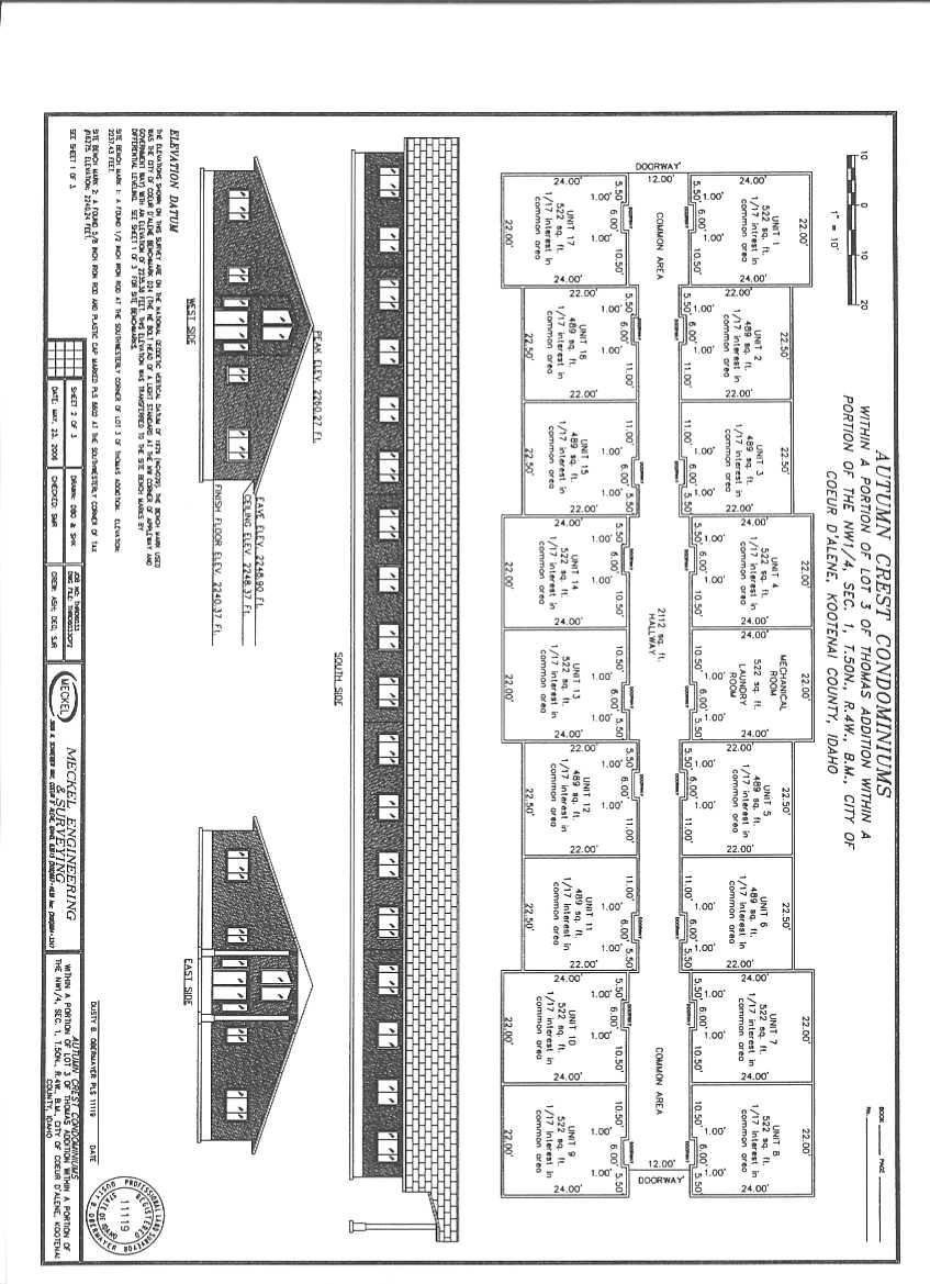
18 TO: Planning Commission FROM: Christopher H. Bates, Project Manager DATE: July 11, 2006 SUBJECT: SS-16-06, Autumn Crest Condominiums DECISION POINT Approve or deny the applicant's request for a 1 building, 17 unit condominium development on Second Street. GENERAL INFORMATION 1. Applicant: Dwight Dirkmaat D.A.C., Inc. PO Box 203 Hayden, ID Request: Approval of a 1 building, 17 unit condominium development. 3. Location: Northerly terminus of 2 nd Street, north of Anton Avenue. PERFORMANCE ANALYSIS 1. Zoning: Existing zoning for the subject property is R-17 which is intended as a medium/high residential area that permits a mix of housing types at a density of 17 units/acre. 2. Land Use: A seventeen (17) unit apartment building currently occupies the sight. 3. Infrastructure: Utilities, Streets, & Storm Water Facilities Utilities: Sewer & Water The subject property is connected to existing City utilities. Streets: Fire: The roadway improvements adjoining the subject property have been previously installed. There is an existing hydrant adjacent to the subject property that meets the spacing requirements of the City Fire Department. Storm Water: Street drainage is already contained in the existing City system. 4. Subdivision Requirement: Due to the condominium nature of the subject development, any and all lien holders on the subject property, will be required to acknowledge the condominium plat and consent to its recordation. Proposed Condition: 1. Any mortgage or lien holder that has a securing interest on the subject property, must acknowledge the condominium development and consent to its recordation by signing an acknowledgement on the final plat document. ss1606pc
19 DECISION POINT RECOMMENDATION Approve the proposed plat in its submitted configuration with the attached condition. ss1606pc
20
21
22 TO: Planning Commission FROM: Christopher H. Bates, Project Manager DATE: July 11, 2006 SUBJECT: SS-17-06, Creekside Meadows DECISION POINT Approve or deny the applicant's request for a two (2) lot residential development. GENERAL INFORMATION 1. Applicant: George Ciccone 3129 E. Springview Drive Coeur d Alene, ID Request: Approval of a two (2) lot residential development. Lot 1: Lot 2: 27,612 square feet 47,619 square feet 3. Location: 23 rd Street, south of French Gulch Road. PERFORMANCE ANALYSIS 1. Zoning: Existing zoning for the subject property is R-3 which is intended as a residential area that allows single family dwelling units at three (3) units per gross acre, on lots that are a minimum of 11,500 square feet. 2. Land Use: The subject property has existing single family dwellings situated on the proposed lots. Infrastructure: Utilities, Streets, & Storm Water Facilities Utilities: Sewer & Water Both structures are connected to City sewer and water utilities. Streets: Fire: The public streets adjoining the subject property are fully developed. No alterations to the site will be required. There is an existing fire hydrant adjacent to the subject property that meets the criteria of the City Fire Department. Proposed Conditions: None Storm Water: Street drainage is managed by the existing stormwater facilities in the adjoining streets and the existing residences drain into the on-site landscaping. DECISION POINT RECOMMENDATION Approve the proposed subdivision plat in its submitted configuration. ss1706pc
23

24 PLANNING COMMISSION STAFF REPORT FROM: JOHN J. STAMSOS, ASSOCIATE PLANNER DATE: JULY 11, 2006 SUBJECT: SP-9-06 REQUEST FOR A PROFESSIONAL OFFICE SPECIAL USE PERMIT IN A LM ZONING DISTRICT LOCATION +/- 1-ACRE PARCEL AT 3932 SCHREIBER WAY IN COMMERCE PARK DECISION POINT: Brian and Brenda Goetz are requesting a Professional Office Special Use Permit in the LM (Light Manufacturing) zoning district to allow construction of two 5,139 sq. ft. buildings (Each building will have a 4,167 sq. ft. main floor and a 972 sq ft. upper level) with a 35 space parking lot for professional offices. GENERAL INFORMATION: A. Site photo. SP-9-06 JULY 11, 2006 PAGE 1
25 B. Zoning C. Generalized land use pattern: SP-9-06 JULY 11, 2006 PAGE 2

26 D. Approved special use permits and zone changes in area. D. Site plan: E. Building elevation. SP-9-06 JULY 11, 2006 PAGE 3
27 F. Applicant/ Brian and Brenda Goetz Owner: 2356 W. Dalton Avenue Cœur d'alene, ID G. Existing land uses in the area include commercial service, professional and administrative offices, civic, wholesale distribution, and vacant lots. G. The subject property is vacant. H. There have been seven Special Use Permits approved in Commerce Park since 1993 for professional and administrative offices or retail uses. (See map on page 3) PERFORMANCE ANALYSIS: A. Zoning: The requested professional office activity is allowed by Special Use Permit in a C-17L zone and is classified as a commercial service activity. Evaluation: The requested use is located in a LM zone and meets the definition of a professional office activity. B. Finding #B8A: That this proposal (is) (is not) in conformance with the Comprehensive Plan policies. 1. The subject property is within the existing city limits. 2. The City Comprehensive Plan Map designates this area as a Transition Area. The subject property is also located on Kathleen Avenue, which is designated as a Medium Intensity Corridor, as follows: Transition Areas: These areas represent the locations where the character of neighborhoods is in transition and, overall, should be developed with care. The street network, the number of building lots and general land use are planned to change greatly within the planning period. Protect and/or enhance the integrity of existing residential areas. Encourage residential when close to jobs and other services. Discourage uses that are detrimental to neighboring uses. Encourage commercial clusters that will serve adjacent neighborhoods vs. city as a whole. Pedestrian/bicycle connections. Encourage cluster developments to maintain open space and forest lands. Overall buildout density approximately = 3 units/acre. Individual lat size will typically not be smaller than 8,000 sq. ft. (5 units/acre). Higher densities and mixed uses encouraged close to abutting transportation corridors. Medium Intensity Corridors: These areas primarily consist of areas where commercial and residential uses may be SP-9-06 JULY 11, 2006 PAGE 4
28 encouraged. Residential/commercial mix. Possible residential density = 17/34 du/acre Encourage lower intensity commercial service and manufacturing uses close or abutting major transportation routes. Discourage uses that are detrimental to neighboring stable established neighborhoods. Arterial/collector corridors defined by landscaping/street trees. Page 28 All requests for zone changes, special use permits etc., will be made considering, but not limited to: 1. The individual characteristics of the site; 2. The existing conditions within the area, and 3. The goals of the community. Significant policies for consideration: 6A: Promote the orderly development of land use at locations that are compatible with public facilities and adjacent land uses. 6A2: Encourage high-intensity commercial development, including professional offices, to concentrate in existing areas so as to minimize negative influences on adjacent land uses, such as traffic congestion, parking and noise. 6A3: Commercial development should be limited to collector and arterial streets. 6A5: Encourage renewal and enhancement of commercial sales and service corridors. 42A: The development of Coeur d Alene should be directed by consistent and thoughtful decisions, recognizing alternatives, effects and goals of citizens. 42A2: Property rights of citizens should be protected in land use decisions. 46A: Provide for the safe and efficient circulation of vehicular traffic. 51A: Protect and preserve neighborhoods both old and new. 62A: Examine all new developments for appropriateness in regard to the character of the proposed area. Inform developers of City requirements and encourage environmentally harmonious projects. Evaluation: The Planning Commission must determine, based on the information before them, whether the Comprehensive Plan policies do or do not support the request. Specific ways in which the policy is or is not supported by this request should be stated in the finding. B. Finding #B8B: The design and planning of the site (is) (is not) compatible with the location, setting, and existing uses on adjacent properties. The subject property is in an existing industrial/commercial park with several existing office and retail uses, has a building design that is compatible with other buildings in the area and provides parking for 35 SP-9-06 JULY 11, 2006 PAGE 5
29 cars. Evaluation: Based on the information presented, the Planning Commission must determine if the request is compatible with surrounding uses and is designed appropriately to blend in with the area. C. Finding #B8C: The location, design, and size of the proposal are such that the development (will) (will not) be adequately served by existing streets, public facilities and services. WATER: Water is available to the site. Evaluation: Discussed need for separate services to the two buildings if any possibility of splitting and selling individually. There are currently two services to the existing lot. Will need additional service for irrigation. Information presented at project review. Submitted by Terry Pickel, Assistant Water Superintendent SEWER: Public sewer is available. Evaluation: The sewer lateral for the applicant s lot was installed as part of the Commerce Park Subdivision. This proposed use will be adequately served by the existing public sewer. Submitted by Don Keil, Assistant Wastewater Superintedent STORMWATER: City Code requires a stormwater management plan to be submitted and approved prior to any construction activity on the site. Any alteration to the subject property will require submission of a stormwater plan detailing the treatment for new impervious surfaces. TRAFFIC: The ITE Trip Generation Manual estimates the project may generate approximately 17 trips per day during the peak hour periods. Evaluation: The adjacent and/or connecting streets will accommodate the traffic volume. STREETS: The subject property is situated on Kathleen Avenue between US Hwy 95 and Ramsey Road, a main east/west collector that is signalized at both opposing intersections. Evaluation: The roadway is fully developed; therefore, no improvements will be required. Submitted by Chris Bates, Engineering Project Manager SP-9-06 JULY 11, 2006 PAGE 6
30 FIRE: We will address issues such as water supply, fire hydrants, Fire Department access, prior to any site development. Submitted by Dan Cochran, Deputy Fire Chief POLICE: The Police department was contacted and had no concerns. Submitted by Steve Childers, Captain Police Department E. Proposed conditions: None proposed. F. Ordinances and Standards Used In Evaluation: ACTION ALTERNATIVES: Comprehensive Plan - Amended Municipal Code. Idaho Code. Wastewater Treatment Facility Plan. Water and Sewer Service Policies. Urban Forestry Standards. Transportation and Traffic Engineering Handbook, I.T.E. Manual on Uniform Traffic Control Devices. The Planning Commission must consider this request and make appropriate findings to approve, deny or deny without prejudice. The findings worksheet is attached. [F:staffrptsSP906] SP-9-06 JULY 11, 2006 PAGE 7
31
32
33 COEUR D'ALENE PLANNING COMMISSION FINDINGS AND ORDER A. INTRODUCTION This matter having come before the Planning Commission on July 11, 2006, and there being present a person requesting approval of ITEM SP-9-06, a request for a Professional Office Special Use Permit in the LM (Light Manufacturing) zoning district LOCATION +/- 1-acre parcel at 3932 Schreiber Way in Commerce Park APPLICANT: Brian and Brenda Goetz B. FINDINGS: JUSTIFICATION FOR THE DECISION/CRITERIA, STANDARDS AND FACTS RELIED UPON (The Planning Commission may adopt Items B1 to B7.) B1. That the existing land uses are commercial service, professional and administrative offices, civic, wholesale distribution, and vacant lots. B2. That the Comprehensive Plan Map designation is Transition B3. That the zoning is LM (Light Manufacturing) B4. That the notice of public hearing was published on, June 24, 2006, and, July 4, 2006,which fulfills the proper legal requirement. B5. That the notice of public hearing was posted on the property on, June 30, 2006, which fulfills the proper legal requirement. B6. That 12 notices of public hearing were mailed to all property owners of record within threehundred feet of the subject property on June 23, 2006, and responses were received: in favor, opposed, and neutral. B7. That public testimony was heard on July 11, B8. Pursuant to Section , Special Use Permit Criteria, a special use permit may be approved only if the proposal conforms to all of the following criteria to the satisfaction of the Planning Commission: PLANNING COMMISSION FINDINGS: SP-9-06 JULY 11, 2006 PAGE 1
34 B8A. B8B. The proposal (is) (is not) in conformance with the comprehensive plan, as follows: The design and planning of the site (is) (is not) compatible with the location, setting, and existing uses on adjacent properties. This is based on Criteria to consider for B8B: 1. Does the density or intensity of the project fit the surrounding area? 2. Is the proposed development compatible with the existing land use pattern i.e. residential, commercial, residential w churches & schools etc? 3. Is the design and appearance of the project compatible with the surrounding neighborhood in terms of architectural style, layout of buildings, building height and bulk, off-street parking, open space, and landscaping? B8C The location, design, and size of the proposal are such that the development (will) (will not) be adequately served by existing streets, public facilities and services. This is based on Criteria to consider B8C: 1. Is there water available to meet the minimum requirements for domestic consumption & fire flow? 2. Can sewer service be provided to meet minimum requirements? 3. Can police and fire provide reasonable service to the property? C. ORDER: CONCLUSION AND DECISION The Planning Commission, pursuant to the aforementioned, finds that the request of BRIAN AND BRENDA GOETZ for a Professional Office special use permit, as described in the application should be (approved)(denied)(denied without prejudice). Special conditions applied are as follows: PLANNING COMMISSION FINDINGS: SP-9-06 JULY 11, 2006 PAGE 2
35 Motion by, seconded by, to adopt the foregoing Findings and Order. ROLL CALL: Commissioner Bowlby Commissioner George Commissioner Jordan Commissioner Messina Commissioner Rasor Commissioner Souza Chairman Bruning Voted Voted Voted Voted Voted Voted Voted (tie breaker) Commissioners were absent. Motion to carried by a to vote. CHAIRMAN JOHN BRUNING PLANNING COMMISSION FINDINGS: SP-9-06 JULY 11, 2006 PAGE 3

36 PLANNING COMMISSION STAFF REPORT FROM: JOHN J. STAMSOS, ASSOCIATE PLANNER DATE: JULY 11, 2006 SUBJECT: A-4-06 ZONE PRIOR TO ANNEXATION S LOT PRELIMINARY PLAT SUBDIVISION LOCATION +/- 3.5 ACRE PARCEL IN THE VICINITY OF 19TH STREET AND NETTLETON GULCH ROAD ADJACENT TO GREYSTONE SUBDIVISION DECISION POINT: Shefoot Investments, LLC is requesting: A. Zoning Prior to Annexation from County Agricultural Suburban to City R-3 (Residential at 3 units/acre). B. Preliminary Plat approval for Shefoot a 5-lot subdivision on +/- 3.5 acres. GENERAL INFORMATION: A. Site photo: A-4-06 & S-8-06 JULY 11, 2006 PAGE 1
37 B. Zoning C. Generalized land use pattern: A-4-06 & S-8-06 JULY 11, 2006 PAGE 2
38 D. Preliminary Plat for Shefoot SUBJECT PROPERTY A-4-06 & S-8-06 JULY 11, 2006 PAGE 3
39 E. Five foot elevation contours: F. Applicant/ Shefoot Investments, LLC Property owner 2863 Sugarpines Drive Coeur d'alene, ID G. Land uses in the area include single-family dwellings and duplexes. H. The subject property contains a single-family dwelling with a tree cover of Ponderosa pine and other native conifers. PERFORMANCE ANALYSIS: A. Zoning: 1. Annexation: A. The proposed zoning is R-3 (Residential at 3 units per gross acre), which is intended as a residential zone for single-family detached housing. B. The zoning in the surrounding area includes R-3, R-3PUD, R-8PUD, R-12 and County Agricultural Suburban. A-4-06 & S-8-06 JULY 11, 2006 PAGE 4
40 C. The minimum requirements in an R-3 zone are 75-feet of frontage on a public street and 11,500 sq. ft. of lot size. 2. Preliminary Plat: A. The maximum allowable density on the site at 3 units/gross acre would be 14-units. The proposal is for 5 single-family lots with an average lot size of 24, 306 sq. ft. (lots range in size from 15, 943 sq. ft. to 38, 159 sq. ft.) for an overall density of 1.4 dwelling units per acre. 3. Evaluation: A. The zoning is generally compatible with the existing development in the area. B. The proposed preliminary plat has a density of 1.4 units per acre, which is less than the maximum allowable density in the R-3 zone of 3 units per acre. C. The preliminary plat should be evaluated to determine that it is consistent with the land use pattern in the area, the street layout is compatible with surrounding streets and the proposal is consistent with Comprehensive Plan policies. D. The Planning Commission, as a condition of approval of the preliminary plat, may establish reasonable requirements as deemed necessary to mitigate any adverse effects of the request. B. ANNEXATION FINDINGS: Finding #B8: That this proposal (is) (is not) in conformance with the Comprehensive Plan policies. 1. The portion of the subject property to be annexed is within the Area of City Impact Boundary. 2. The City Comprehensive Plan Map designates the subject property a Transition Area, as follows: Transition Areas: These areas represent the locations where the character of neighborhoods is in transition and, overall, should be developed with care. The street network, the number of building lots and general land use are planned to change greatly within the planning period. Protect and/or enhance the integrity of existing residential areas. Encourage lower intensity commercial service and manufacturing uses close or abutting major transportation routes. Encourage residential when close to jobs and other services. Discourage uses that are detrimental to neighboring uses. Encourage commercial clusters that will serve adjacent neighborhoods vs. city as a whole. Pedestrian/bicycle connections. Encourage cluster housing developments to maintain open space and forestlands. Overall build-out density approximately 3 dwelling units per acre. Individual lot A-4-06 & S-8-06 JULY 11, 2006 PAGE 5
41 size will typically not be smaller than 8,000 sq. ft. (5 du s/acre). Higher densities and mixed uses encouraged close or abutting transportation corridors. Neighborhood development should consist of: Size of 25 to 65 acres Urban services Sidewalks/bike paths Street trees Neighborhood parks Interconnecting street network Significant policies: 4A: Establish limits and priorities of urban services. 4A1: Initial limits should be based upon existing capabilities. 4B1: Annexations should be made within the adopted city impact area". 4B2: Annexations should be effected in a manner that promotes an orderly growth pattern. 4C: New growth should enhance the quality and character of existing areas and the general community. 4C1: Development that proposes to increase the density of a given area may be allowed, provided that the increase maintains the character of the community. 4C2: Urban developments that propose to decrease the need for expanded transportation facilities should be encouraged. 4C3: Population growth should be compatible with preserving Coeur d Alene s character and quality of life. 4C4: Residential and mixed use development should be encouraged. 4C5: New development should provide for bike paths and pedestrian walkways in accordance with the transportation plan and bike plan. 6A: Promote the orderly development of land use at locations that are compatible with public facilities and adjacent land uses. 14A3: All new developments must provide for immediate hook up to the sanitary sewer system. 24C: Natural vegetative cover should remain as a dominant characteristic of Coeur d Alene. 42A2: Property rights of citizens should be protected in land use decisions. 42B2: Expansion of the City should be based upon conformance to the urban service area. 42C1: Providing service to new areas should not be at the expense of areas presently being serviced. A-4-06 & S-8-06 JULY 11, 2006 PAGE 6
42 Transportation Plan policies: The Transportation Plan is an addendum to the Comprehensive Plan and is a policy document that is intended to guide decisions that affect transportation issues. Its goal is to correct existing deficiencies and to anticipate, plan and provide for future transportation needs. 31A: Develop an improved arterial system that integrates with existing street patterns. 33A: Safe vehicular and pedestrian circulation should be enhanced through careful design and active enforcement. 34A: Use existing street systems better. 34B: Reduce automobile dependency by providing bike paths and sidewalks. 38A: Improve traffic safety by zoning actions and infrastructure improvements. 40A: New street construction should enhance the visual and physical environment. 3. Evaluation: The Planning Commission must determine, based on the information before them, whether the Comprehensive Plan policies do or do not support the request. Specific ways in which the policy is or is not supported by this request should be stated in the finding. Finding #B9: That public facilities and utilities (are) (are not) available and adequate for the proposed use. See preliminary plat finding #B8B pages 7 & 8. Finding #B10: That the physical characteristics of the site (make) (do not make) it suitable for the request at this time. The subject property is relatively flat with the exception of lots 4 and 5 that have contours in excess of 15% average slope, which would require compliance with the City's Hillside Regulations.. Evaluation: Development of lots 4 and 5 would "trigger" compliance with the Hillside Regulations.. Finding #B11: That the proposal (would) (would not) adversely affect the surrounding neighborhood with regard to traffic, neighborhood character, (and) (or) existing land uses. The subject property is in an established single-family neighborhood, the proposed zoning is R-3, which allows single-family development only and has an overall density of 1.4 dwelling units per acre, A-4-06 & S-8-06 JULY 11, 2006 PAGE 7
43 which is consistent with the Comprehensive Plan Transition Area designation (Overall build-out density approximately 3 dwelling units per acre. Individual lot size will typically not be smaller than 8,000 sq. ft. (5 du's/acre). The proposed annexation will also partially fill in one of the unincorporated areas surrounded by city limits and provide an opportunity for infill development. C. PRELIMINARY PLAT FINDINGS: Finding #B8A: That all of the general preliminary plat requirements (have) (have not) been met, as attested to by the City Engineer. The preliminary plat submitted contained all of the general information required by Section of the Municipal Code, General Requirements. Finding #B8B: That the provisions for streets, alleys, rights-of-way, easements, street lighting, fire protection, planting, drainage, and utilities (are) (are not) adequate where applicable. SEWER: Sanitary sewer is available to the proposed subdivision. Evaluation: There is an existing sanitary main line located at the intersection of 19 th Street and Nettleton Gulch Road. This line is of adequate size to serve the proposed subdivision; however, the sewer main will need to be extended from this location to the proposed development. Design plans will be required to be submitted and approved prior to any construction activity on the subject property. Service laterals will be required to be installed for the adjoining properties situated between the subject property and Nettleton Gulch Road to provide future connections to the sewer without cutting into the newly constructed street. All sanitary main lines and laterals will be extended at no cost to the City. WATER: City water is available to the proposed subdivision. There is an existing six inch (6 ) water main located in Nettleton Gulch Road that serves as a single feed that provides water service to the existing residence on the subject property. Evaluation: 1. the existing water main is undersized for the development and does not provide fire flows necessary to provide service. The developer will be required to replace the existing water main in Nettleton Gulch Road with a City standard eight inch (8 ) C-900 water main that will be required to make a looping connection to Willow Road adjoining the subject property. 2. The loop connection to Willow Road will be required to be placed within a twenty foot (20 ) easement dedicated to the City, with a ten foot (10 ) paved pathway over the top, and, fenced along both sides. 3. The replacement of this six inch (6 ) line will be required to extend to the connection point in Nettleton Gulch Road where there is an existing eight A-4-06 & S-8-06 JULY 11, 2006 PAGE 8
44 STORMWATER: inch (8 ) main at 19 th Street. The City Water Department will participate in the cost difference between the 6 and the 8 pipe sizing. All cost of installation will be the responsibility of the developer with the City only participating in the pipe upsizing. 4. Fire hydrant installations will be determined during the review of subdivision improvement plans for the subject property. City Code requires a stormwater management plan to be submitted and approved prior to any construction activity on the site. Evaluation: A detailed stormwater plan with sizing calculations and showing swale locations will be required to be submitted with any infrastructure plans for the subject property. TRAFFIC: The ITE Trip Generation Manual estimates the project will generate approximately 4.5 trips during the peak hour periods. Evaluation: The adjacent and/or connecting streets will accommodate the additional traffic volume. STREETS: 1. The proposed subdivision is bordered by Nettleton Gulch Road to the south. The current right-of-way width varies along its length, as does the jurisdictional control over the roadway (City & Lakes Highway District). Evaluation: Additional right-of-way (if necessary) on Nettleton Gulch Road along the subject property s frontage will be required to be dedicated to the City if the existing r/w for the half section of roadway is less than thirty feet (30 ). The applicant's surveyor will need to present adequate information to the City in order to make that determination. 2. The proposed street accessing the development is situated within a fifty foot (50 ) r/w that widens to the standard sixty feet (60 ) with a ten foot (10 ) utility easement after it passes some intervening properties. Evaluation: The proposed interior right-of-way meets City standards, however, the utility easement will be required to be widened to fifteen feet (15 ) in order to accommodate sidewalk. A City standard thirty six foot (36 ) street width, with a minimum fifty foot (50 ) radius cul-de-sac will be required to be constructed. The required typical section of will consist of the street/swale section in the right-ofway and the sidewalk/private utilities in the easement. APPLICABLE CODES AND POLICIES: UTILITIES 1. All proposed utilities within the project shall be installed underground. 2. All water and sewer facilities shall be designed and constructed to the requirements of the City of Coeur d Alene. Improvement plans conforming to City guidelines shall be A-4-06 & S-8-06 JULY 11, 2006 PAGE 9
45 submitted and approved by the City Engineer prior to construction. 3. All water and sewer facilities servicing the project shall be installed and approved prior to issuance of building permits. 4. All required utility easements shall be dedicated on the final plat. STREETS 5. All new streets shall be dedicated and constructed to City of Coeur d Alene standards. 6. Street improvement plans conforming to City guidelines shall be submitted and approved by the City Engineer prior to construction. 7. All required street improvements shall be constructed prior to issuance of building permits. 8. An encroachment permit shall be obtained prior to any work being performed in the existing right-of-way. STORMWATER 9. A stormwater management plan shall be submitted and approved prior to start of any construction. The plan shall conform to all requirements of the City. GENERAL 10. The final plat shall conform to the requirements of the City. Submitted by Chris Bates, Engineering Project Manager FIRE: We will address any fire department issues such as water supply and fire department access, prior to any site development. Submitted by Dan Cochran, Deputy Fire Chief POLICE: I have no comments at this time. Submitted by Steve Childers, Captain, Police Department Finding #B8C: That the preliminary plat (is) (is not) in conformance with the Comprehensive Plan as follows: See annexation finding #B8 on pages 5-7. Finding #B8D. That the public interest (will) (will not) be served. The proposed plat is within the Coeur d Alene Area of City Impact boundary, is requesting an R-3 A-4-06 & S-8-06 JULY 11, 2006 PAGE 10
46 zoning classification, which has a density that is consistent with the Transition Area designation, is compatible with existing development in the area, is served adequately by public services and facilities and has a street layout plan that adequately connects proposed streets to existing streets. Evaluation: The Planning Commission must determine, based on the information before them, whether the request will or will not serve the public interest. Specific ways in which this request does or does not should be stated in the finding. Finding #B8E: That all of the required engineering elements of the preliminary plat (have) (have not) been met, as attested to by the City Engineer. A preliminary utility design was submitted indicating that all proposed lots can be served. Finding #B8F: That the lots proposed in the preliminary plat (do) (do not) meet the requirements of the applicable zoning district. All lots within the proposed plat meet the R-3 zone minimum lot size and frontage requirements. Evaluation: The Planning Commission must determine, based on the information before them, whether the request does or does not meet the minimum requirements of the R-3 zoning district. Finding #B9: That the proposal (would) (would not) adversely affect the surrounding neighborhood at this time with regard to traffic, neighborhood character, and existing land uses. See annexation finding # B11 pages 7 & 8. D. Proposed conditions for S-8-06: 1. The sanitary sewer main will need to be extended from its location at Nettleton Gulch Road and 19 th Street to the proposed development. Service laterals will be required to be installed for the adjoining properties situated between the subject property and Nettleton Gulch Road to provide future connections. All sanitary main lines and laterals will be extended at no cost to the City. 2. The developer will be required to replace the existing water main in Nettleton Gulch Road with a City standard eight inch (8 ) C-900 water main that will be required to make a looping connection to Willow Road adjoining the subject property. 3. The loop connection to Willow Road will be required to be placed within a twenty foot (20 ) easement dedicated to the City with a ten foot (10 ) paved pathway over the top and fenced along both sides. A-4-06 & S-8-06 JULY 11, 2006 PAGE 11
47 4. The replacement of this six inch (6 ) line will be required to extend to the connection point in Nettleton Gulch Road where there is an existing eight inch (8 ) main at 19 th Street. The City Water Department will participate in the cost difference between the 6 and the 8 pipe sizing. All cost of installation will be the responsibility of the developer with the City only participating in the pipe upsizing. 5. Additional right-of-way (if necessary) on Nettleton Gulch along the subject property s frontage will be required to be dedicated to the City if the existing rightof-way for the half section of roadway is less than thirty feet (30 ). The applicant's surveyor will need to present adequate information to the City in order to make that determination. E. Ordinances and Standards Used In Evaluation: Comprehensive Plan - Amended Municipal Code. Idaho Code. Wastewater Treatment Facility Plan. Water and Sewer Service Policies. Urban Forestry Standards. Transportation and Traffic Engineering Handbook, I.T.E. Manual on Uniform Traffic Control Devices. ACTION ALTERNATIVES: The Planning Commission must consider this request and make appropriate findings to approve, deny or deny without prejudice. The findings worksheet is attached. [D:staffrptsA406&S806] A-4-06 & S-8-06 JULY 11, 2006 PAGE 12
48
49
50 COEUR D'ALENE PLANNING COMMISSION FINDINGS AND ORDER A. INTRODUCTION This matter having come before the Planning Commission on July 11, 2006, and there being present a person requesting approval of ITEM A-4-06, a request for zoning prior to annexation from County Agricultural Suburban to City R-3 (Residential at 3 units/acre). LOCATION: +/- 3.5 acre parcel in the vicinity of 19th Street and Nettleton Gulch Road adjacent to Greystone Subdivision APPLICANT: Shefoot Investments, LLC B. FINDINGS: JUSTIFICATION FOR THE DECISION/CRITERIA, STANDARDS AND FACTS RELIED UPON (The Planning Commission may adopt Items B1-through7.) B1. That the existing land uses are single-family dwellings and duplexes. B2. That the Comprehensive Plan Map designation is Transition B3. That the zoning is County Agricultural Suburban B4. That the notice of public hearing was published on, June 24, 2006, and, July 4, 2006, which fulfills the proper legal requirement. B5. That the notice of public hearing was not required to be posted, which fulfills the proper legal requirement. B6. That 78 notices of public hearing were mailed to all property owners of record within threehundred feet of the subject property on June 23, 2006,and responses were received: in favor, opposed, and neutral. B7. That public testimony was heard on July 11, B8. That this proposal (is) (is not) in conformance with the Comprehensive Plan policies as follows: PLANNING COMMISSION FINDINGS: A-4-06 JULY 11, 2006 PAGE 1
51 B9. That public facilities and utilities (are) (are not) available and adequate for the proposed use. This is based on Criteria to consider for B9: 1. Can water be provided or extended to serve the property? 2. Can sewer service be provided or extended to serve the property? 3. Does the existing street system provide adequate access to the property? 4. Is police and fire service available to the property? B10. That the physical characteristics of the site (do) (do not) make it suitable for the request at this time because Criteria to consider for B10: 1. Topography. 2. Streams. 3. Wetlands. 4. Rock outcroppings, etc. 5. vegetative cover. B11. That the proposal (would) (would not) adversely affect the surrounding neighborhood with regard to traffic, neighborhood character, (and) (or) existing land uses because Criteria to consider for B11: 1. Traffic congestion. 2. Is the proposed zoning compatible with the surrounding area in terms of density, types of uses allowed or building types allowed? 3. Existing land use pattern i.e. residential, commercial, residential w churches & schools etc. PLANNING COMMISSION FINDINGS: A-4-06 JULY 11, 2006 PAGE 2
52 C. ORDER: CONCLUSION AND DECISION The Planning Commission, pursuant to the aforementioned, finds that the request of SHEFOOT INVESTMENTS, LLC for zoning prior to annexation, as described in the application should be (approved) (denied) (denied without prejudice). Suggested provisions for inclusion in an Annexation Agreement are as follows: Motion by, seconded by, to adopt the foregoing Findings and Order. ROLL CALL: Commissioner Bowlby Commissioner George Commissioner Jordan Commissioner Messina Commissioner Rasor Commissioner Souza Chairman Bruning Voted Voted Voted Voted Voted Voted Voted (tie breaker) Commissioners were absent. Motion to carried by a to vote. CHAIRMAN JOHN BRUNING PLANNING COMMISSION FINDINGS: A-4-06 JULY 11, 2006 PAGE 3
53
54
55 COEUR D'ALENE PLANNING COMMISSION FINDINGS AND ORDER A. INTRODUCTION This matter having come before the Planning Commission on July 11, 2006, and there being present a person requesting approval of ITEM S-8-06: a request for preliminary plat approval of Shefoot, a 5-lot subdivision located in the R-3 (Residential at 3 units/acre). zoning district.. LOCATION: +/- 3.5 acre parcel in the vicinity of 19th Street and Nettleton Gulch Road adjacent to Greystone Subdivision APPLICANT: Shefoot Investments, LLC B. FINDINGS: JUSTIFICATION FOR THE DECISION/CRITERIA, STANDARDS AND FACTS RELIED UPON (The Planning Commission may adopt Items B1-through7.) B1. That the existing land uses are single-family dwellings and duplexes. B2. That the Comprehensive Plan Map designation is Transition B3. That the zoning is County Agricultural Suburban B4. That the notice of public hearing was published on, June 24, 2006, and, July 4, 2006, which fulfills the proper legal requirement. B5. That the notice was not required to be posted on the property. B6. That 78 notices of public hearing were mailed to all property owners of record within three-hundred feet of the subject property on June 23, 2006,and responses were received: in favor, opposed, and neutral. B7. That public testimony was heard on July 11, B8. Pursuant to Section A.1, Preliminary Plats: In order to approve a preliminary plat, the Planning Commission must make the following findings: PLANNING COMMISSION FINDINGS: S-8-06 JULY 11, 2006 PAGE 1
56 B8A. That all of the general preliminary plat requirements (have) (have not) been met as attested to by the City Engineer. This is based on B8B. That the provisions for streets, alleys, rights-of-way, easements, street lighting, fire protection, planting, drainage, and utilities (are) (are not) adequate where applicable. This is based on B8C. That the preliminary plat (is) (is not) in conformance with the Comprehensive Plan as follows: B8D. That the public interest (will) (will not) be served based on Criteria to consider for B8D: 1. Does this request achieve the goals and policies of the comp plan? 2. Does it provide for orderly growth and development that is compatible with uses in the surrounding area? 3. Does it protect the public safety by providing adequate public utilities and facilities to mitigate any development impacts? 4. Does the it protect and preserve the natural beauty of Coeur d Alene? 5. Does this have a positive impact on Coeur d Alene s economy? 6. Does it protect property rights and enhance property values? B8E. That all of the required engineering elements of the preliminary plat (have) (have not) been met, as attested to by the City Engineer. This is based on PLANNING COMMISSION FINDINGS: S-8-06 JULY 11, 2006 PAGE 2
57 B8F That the lots proposed in the preliminary plat (do) (do not) meet the requirements of the applicable zoning district for the following reasons: Criteria to consider for B8F: 1. Do all lots meet the required minimum lat size? 2. Do all lots meet the required minimum street frontage? 3. Is the gross density within the maximum allowed for the applicable zone? B9. That the proposal (would) (would not) adversely affect the surrounding neighborhood at this time with regard to traffic, neighborhood character, and existing land uses because Criteria to consider for B9: 1. Can the existing street system support traffic generated by this request? 2. Does the density or intensity of the project fit the surrounding area? 3. Is the proposed development compatible with the existing land use pattern? i.e. residential, commercial, residential w churches & schools etc. 4. Is the design and appearance of the project compatible with the surrounding neighborhood? C. ORDER: CONCLUSION AND DECISION The Planning Commission, pursuant to the aforementioned, finds that the request of SHEFOOT INVESTMENTS, LLC for preliminary plat of approval as described in the application should be (approved) (denied) (denied without prejudice). Special conditions applied to the motion are: Motion by, seconded by, to adopt the foregoing Findings and Order. PLANNING COMMISSION FINDINGS: S-8-06 JULY 11, 2006 PAGE 3
58 ROLL CALL: Commissioner Bowlby Commissioner George Commissioner Jordan Commissioner Messina Commissioner Rasor Commissioner Souza Chairman Bruning Voted Voted Voted Voted Voted Voted Voted (tie breaker) Commissioners were absent. Motion to carried by a to vote. CHAIRMAN JOHN BRUNING PLANNING COMMISSION FINDINGS: S-8-06 JULY 11, 2006 PAGE 4

59 PLANNING COMMISSION STAFF REPORT FROM: JOHN J. STAMSOS, ASSOCIATE PLANNER DATE: JULY 11, 2006 SUBJECT: S-1-05m A 26-LOT RE-PLAT OF THE ORIGINAL PRELIMINARY PLAT SUBDIVISION LOCATION +/- 77-ACRE PARCEL KNOWN AS THE CENTRAL PRE-MIX SITE AT 2800 SELTICE WAY. DECISION POINT: Riverstone West, LLC is requesting approval of a 26-lot re-plat of the original 82-lot "Riverstone West" Preliminary Plat subdivision. The following changes are the only changes from the original preliminary plat: Reduce the number of lots from 82 to 26. Change the phasing boundaries and expand from 2 to 3 phases. Re-configure Park Lane to better access future park and lake. GENERAL INFORMATION: A. Site photo SUBJECT PROPERTY S-1-05m JULY 11, 2006 PAGE 1

60 B. Zoning. C. Generalized land use. S-1-05m JULY 11, 2006 PAGE 2


61 D. The original "Riverstone West" Preliminary Plat : Riverstone Drive Seltice Way E. Proposed revisions to original Preliminary Plat: S-1-05m JULY 11, 2006 PAGE 3
62 Seltice Way Riverstone Drive S-1-05m JULY 11, 2006 PAGE 4
63 F. Applicant: Riverstone West LLC 104 S. Division Street Spokane, WA G. Land uses in the area include residential multi-family, commercial retail sales service. H. The subject property contains the Central Pre-mix gravel and concrete operations. I. Previous actions on subject property: 1. A Zoning prior to annexation was approved by the Planning Commission on October 12, A-3-04 Annexation in conjunction with zoning was approved by the City Council on November 16, I Interpretation - Approved by the Planning Commission on January 12, I Interpretation - Approved by the Planning Commission June 13, PERFORMANCE ANALYSIS: A. Zoning: The subject property is zoned C-17 and will not change with this request. The C-17 zoning district is intended as a broad spectrum commercial district that permits limited service, wholesale/retail and heavy commercial in addition to allowing residential development at a density of seventeen (17) units per gross acre. This District should be located adjacent to arterials. The C-17 zone allows 57 uses by right and 10 uses by special use permit. The zoning pattern in the area shows C-17 zoning in the Riverstone development to the south and along both Seltice and Northwest Boulevards, which are designated as minor arterials on the Transportation Plan. There are no minimum lot size or frontage requirements for commercial lots in a C-17 zone and the minimum requirement for access is legal access. Evaluation: The preliminary plat should be evaluated to determine that it is compatible with the land uses in the area, the surrounding street pattern, and the Comprehensive Plan. B. Finding #B8A: That all of the general preliminary plat requirements (have) (have not) been met, as attested to by the City Engineer. The preliminary plat submitted contained all of the general information required by Section of the Municipal Code, General Requirements. S-1-05m JULY 11, 2006 PAGE 5
64 C. Finding #B8B: That the provisions for streets, alleys, rights-of-way, easements, street lighting, fire protection, planting, drainage, and utilities (are) (are not) adequate where applicable. SEWER: 1. A portion of the proposed development will be utilizing the sanitary sewer lift station that was installed as an element of the public improvements for the Riverstone 1 st Addition. The new lift station is substantially complete but has not yet been accepted by the City. Evaluation: The City must accept The Riverstone lift station, prior to the approval of the subdivision improvement plans for Phase 1 of the proposed development. 2. There is an existing sanitary sewer interceptor with an easement that crosses Lots 8, 9, & 10 of Block 3 (shown on the preliminary plat submittal) along the westerly boundary of proposed Phase 2. Evaluation: Development adjoining the existing sanitary interceptor will not be able to encroach into the existing easement without prior City approval. Access to the line situated within the easement will need to be maintained. 3. A portion of the development will connect to the existing Riverside Interceptor to provide sewer to portions of the project that are at a grade that will allow connection. Evaluation: Any collection sewers connected to the existing sanitary interceptor line will be required to connect at an existing manhole. Individual connections (i.e.: service taps) are not allowed on any City line greater than fifteen inches (15 ) in diameter. 4. The north side of this proposed development has an existing oversized and older gravity line that requires replacement. Evaluation: The preliminary plat shows a replacement line that improves the delivery of sewer to the properties bordering Seltice Way (north of the subject property). The Wastewater Department supports the change of this line, which reduces the impact on development of the adjoining lots, reduces the odors associated with the greatly reduced flows that now exist, and, the abandonment or the easement that exists over that line. A new easement will need to be dedicated over the replacement line on the final plat. 5. The proposed subdivision is a heavily used surface mining facility that has a large open pit gravel mine that is still in operation and in places approaches 100-feet in depth. The proposed development is planning to have public roadways and utilities located over and through the area constituted by the pit. S-1-05m JULY 11, 2006 PAGE 6
65 Evaluation: All facilities that are placed into the area that constitutes the pit site will need to be installed following the recommendations and supervision of a licensed geo-technical engineer. An extended warranty period (3 years) will be required for all facilities located in the fill zones to warrant against damage to installed facilities due to differential settlement that may occur in the fill. Submitted by Don Keil, Assistant Water Superintendent WATER: 1. City water is available to the proposed subdivision. Evaluation: There are existing twelve-inch (12 ) water mains located in Seltice Way, and at the southeast corner of the subject property in Beebe Boulevard in the Riverstone development. These lines are of adequate size to serve the area and will need to be extended to the far property westerly line as the subject property is developed. With Phase 1, a looping connection will need to be made from the connection point at Beebe Boulevard and Riverstone Drive, to the existing main in Seltice Way. A twenty- to foot (20 ) easement will need to be provided over the water line provide for access and maintenance of the installed line. With the initiation of phase 2 of the development, the twelve inch (12 ) main will need to be extended to the westerly boundary of the subject property where it adjoins the railroad right-of-way, as shown on the preliminary submittal. Other mains will be 8" and 6" as approved during the formal review of the utility plans. All utility extensions will be the responsibility of the developer and installed at no cost to the City. 2. Prior water use on the subject property has been furnished by private individual water wells. Evaluation: The developer is proposing to utilize the existing private wells for irrigation and for the water feature in the development. All wells will be required to be located on the plat document and shown on individual lots to facilitate any future transfer of ownership, should that situation arise. 3. There are existing off-site private wells and private water mains situated on the subject property that provide water service to the Cougar Ridge development, which is located south of the Spokane River. Evaluation: Easements for these private mains will need to be identified and dedicated on the plat document. Because these water lines are considered a private utility and not under the jurisdiction of the City, the development layout will need to be designed to keep the private water line out of the public right-of-ways. 4. The proposed subdivision is a heavily used surface mining facility that has a large open pit gravel mine that is still in operation and in places approaches 100-feet in S-1-05m JULY 11, 2006 PAGE 7
66 depth. The proposed development is planning to have public roadways and utilities located over and through the area constituted by the pit. Evaluation: All facilities that are placed into the area that constitutes the pit site will need to be installed following the recommendations and supervision of a licensed geo-technical engineer. An extended warranty period (3 years) will be required for all facilities located in the fill zones to warrant against damage to installed facilities due to differential settlement that may occur in the fill. The installed water mains will need to be placed so that the amount of cover over the pipe never exceeds six (6 ) feet, nor is less than four and one-half feet (4 6 ). 5. Lots 8-12, Block 1 and 7 & 8, Block 2 are proposed to have access by easement across another parcel or by private driveway/roadway, rather than fronting directly on a public street. Evaluation: It will be required that all lots will have direct access to the water main utilities, and, that these utilities be installed across the frontage of all proposed lots. Submitted by Jim Markley, Water Superintendent STORMWATER: 1. City Code requires a stormwater management plan to be submitted and approved prior to any construction activity on the site. Best Management Practices (BMP s) need to be utilized that will control all areas that may pose any threat of erosion to the Spokane River. Also, the developer will need to adhere to any Idaho Department of Environmental Quality (IDEQ) or Idaho Department of Lands requirements, including but not limited to permits or erosion control practices, that may be required due to the proximity to a water resource. TRAFFIC: 1. Due to the complexity of the proposed development, a traffic impact analysis was performed to address existing and future traffic concerns. The evaluation addresses the concerns, current, and future remediation requirements that will need to occur as conditions of approval. The traffic study calls for the signalization of the Lakewood Drive/Riverstone Drive intersection with the build out of Phase 1 construction and the signalization of the Seltice Way/Riverstone Drive intersection with the build out of Phase 2. Evaluation: The installation of the signalization and intersection modifications at the Lakewood/Riverstone intersection will be required with the build out of Phase 1, or, three (3) years from final plat approval of Phase 1, whichever comes first. Bonding for the signal installation and intersection modifications will need to accompany final plat approval of Phase 1 to assure the installation of the facilities should the developer default on the installation. S-1-05m JULY 11, 2006 PAGE 8
67 Construction of the signalized intersection at Seltice Way and Riverstone Drive, will be required to be completed with the initiation of the Phase 2 improvements. No roadway access will be allowed onto Seltice Way from the subject property until the signalized intersection is installed. 2. The scheduled replacement of the Seltice Way/UPRR bridge and the portion of Seltice Way adjoining the subject property have been postponed pending the resolution of the abandonment of the UPRR track line. Construction of the new bridge structure and the associated improvements will have an impact and/or be impacted by Phase 2 of the development. Evaluation: Should this bridge and road project come to fruition prior to the initiation of Phase 2 of the subject development, the developer will be required to install the improvements required for the signalization, or, provide the funding necessary for the design, purchase, and installation for all materials, required for the signalization of the future Riverstone Drive/Seltice Way intersection. STREETS: 1. The proposed subdivision is bordered by Seltice Way on the north and connects with Riverstone Drive to the east. The current and proposed right-of-way widths meet City standards. Evaluation: All streets within the right-of-ways will be required to follow City of Coeur d' Alene standards and will be measured to the face of curb, not the back of curb. The proposed Riverstone Drive will need to be 40-feet to the face of curb. 2. The proposed Phase 1 has a street, John Loop, which extends into the excavated pit site. Evaluation: The pit site underlying the roadway section will be required to be brought up to grade following the recommendations of the geotechnical report and to the satisfaction of the City Engineer, prior to the submission of the infrastructure improvement plans for Phase Improvements to the Seltice Way frontage will be are required. These improvements include but are not limited to curb & gutter, sidewalk installation, pavement widening and stormwater drainage facilities construction. Evaluation: These improvements are scheduled to be constructed with the Seltice Way reconstruction project, however, since that State of Idaho project has been postponed indefinitely, the developer will be required to install those improvements, at no cost to the City and per the plans on file in the City Engineers office, if they are not in place at the time of the initiation of Phase 2 of the Riverstone West project. SUBDIVISION IMPROVEMENTS: S-1-05m JULY 11, 2006 PAGE 9
68 1. A certified geotechnical report detailing the entire development (Phases 1 & 2) will be required to be submitted prior to the approval of improvement plans for Phase 1. This report will need to address site remediation, grading, fill and compaction, erosion control, building site development, footing and foundation requirements, utility main installations and roadway construction with recommendations and procedures necessary for the proper development of the subject property. The report should also address the disparity between the depth of the Spokane River, the depth of the excavated pit site on the subject property (which is considerably lower than the bottom of the river), and any precautions that should be undertaken to ensure that there is no breech in the barrier separating them. 2. The proposed water feature is shown on the preliminary submittal as being its own separate lot (Lot 9), therefore, an access easement will be required across Lot 8 that provides for access and maintenance to/for Lot 9. APPLICABLE CODES AND POLICIES: UTILITIES All proposed utilities within the project shall be installed underground. All water and sewer facilities shall be designed and constructed to the requirements of the City of Coeur d Alene. Improvement plans conforming to City guidelines shall be submitted and approved by the City Engineer prior to construction. All water and sewer facilities servicing the project shall be installed and approved prior to issuance of building permits. All required utility easements shall be dedicated on the final plat. STREETS All new streets shall be dedicated and constructed to City of Coeur d Alene standards. Street improvement plans conforming to City guidelines shall be submitted and approved by the City Engineer prior to construction. All required street improvements shall be constructed prior to issuance of building permits. An encroachment permit shall be obtained prior to any work being performed in the existing right-of-way. STORMWATER A stormwater management plan shall be submitted and approved prior to start of any construction. The plan shall conform to all requirements of the City. FIRE PROTECTION A fire hydrant(s) shall be installed at locations and per the spacing requirements of the City of Coeur d' Alene Fire Department. GENERAL S-1-05m JULY 11, 2006 PAGE 10
69 The final plat shall conform to the requirements of the City. Prior to approval of the final plat, all required improvements must be installed and accepted by the City. The developer may enter into an agreement with the City guaranteeing installation of the improvements and shall provide security acceptable to the City in an amount equal to 150 percent of the cost of installation of the improvements as determined by the City Engineer. The agreement and security shall be approved by the City Council prior to recording the final plat. The Covenants, Conditions, and Restrictions and/or Articles of Incorporation of the homeowner s association shall be subject to review for compliance with the conditions herein by the City Attorney. Submitted by Chris Bates, Project Manager PARKS: Riverstone Development contacted the CDA Parks Department approximately one year ago regarding a six-acre lake and an acre of open space land surrounding the lake. Riverstone had suggested that the City own and maintain the lake and the open space. I advised Riverstone at that time that it would not be in the City s best interest to own the lake or the land. Long term care of a body of water can be very expensive and there is always the concern of adults and/or children entering the lake and drowning. The CDA City Parks Department is not equipped to maintain bodies of water. Several developers in the community have explored this concept and have abandoned the idea largely due to the problems associated with long term maintenance and liability issues. I suggested to Riverstone that they form an association, transfer ownership of the lake and land to the association and let them maintain it through association dues. I also suggested that they contact other agencies that are better equipped to manage bodies of water. To date there has not been an interest by other entities to own and maintain the lake. The one-acre of open space around the lake is only large enough to serve as a buffer. If owned by the city, this small strip of land would have little recognizable benefit to the public. Also, the maintenance costs of this small strip around the lake would likely be higher than other parklands. Riverstone West is a commercial development. Although it is feasible for residents to enter a commercial area for outdoor leisure activity, it is not common. More direct beneficiaries to this project would be the business owners and their clients, not necessarily the general public. The Parks and Recreation Commission has discussed this concept several times and their consensus recommendation is that the City does not participate in ownership or maintenance of the lake or the land. Comments submitted by Doug Eastwood, Parks Director FIRE: We will address any Fire Department issues such as water supply, fire hydrants and fire department access, prior to any site development. Submitted by Dan Cochran, Deputy Fire Chief S-1-05m JULY 11, 2006 PAGE 11
70 POLICE: No further comments. Submitted by Steve Childers, Captain, Police Department D. Finding #B8C: That the preliminary plat (is) (is not) in conformance with the Comprehensive Plan as follows: 1. The subject property is within the existing city limits. 2. The City Comprehensive Plan Map designates the subject property as Transition as follows: Transition: These areas represent the locations where the character of neighborhoods is in transition and, overall, should be developed with care. The street network, the number of building lots, and general land use are planned to change greatly within the planning period. Protect and/or enhance the integrity of existing residential areas. Encourage lower intensity commercial service and manufacturing uses close or abutting major transportation routes. Encourage residential when close to jobs and other services. Discourage uses that are detrimental to neighboring uses. Encourage commercial clusters that will serve adjacent neighborhoods vs. city as a whole. Pedestrian/bicycle connections. Encourage cluster housing developments to maintain open space and forestlands. Overall build-out density approximately 3 dwelling units per acre. Individual lot size will typically not be smaller than 8,000 sq. ft. (5 du s/acre). Higher densities and mixed uses encouraged close or abutting transportation corridors. Neighborhood development should consist of: Size of 25 to 65 acres Urban services Sidewalks/bike paths Street trees Neighborhood parks Interconnecting street network Medium Intensity Corridors: These areas primarily consist of areas where commercial and residential uses may be encouraged. Residential/commercial mix. Possible residential density = 17/34 du/acre Encourage lower intensity commercial service and manufacturing uses close S-1-05m JULY 11, 2006 PAGE 12
71 or abutting major transportation routes. Discourage uses that are detrimental to neighboring stable established neighborhoods. Arterial/collector corridors defined by landscaping/street trees. Page 28 All requests for zone changes, special use permits etc., will be made considering, but not limited to: The individual characteristics of the site; The existing conditions within the area, and The goals of the community. Significant policies: 4C: New growth should enhance the quality and character of existing areas and the general community. 4C1: Development that proposes to increase the density of a given area may be allowed, provided that the increase maintains the character of the community. 4C3: Population growth should be compatible with preserving Coeur d Alene s character and quality of life. 4C5: New development should provide for bike paths and pedestrian walkways in accordance with the transportation plan and bike plan. 6A: Promote the orderly development of land use at locations that are compatible with public facilities and adjacent land uses. 6A2: Encourage high-intensity commercial development, including professional offices, to concentrate in existing areas so as to minimize negative influences on adjacent land uses, such as traffic congestion, parking and noise. 6A3: Commercial development should be limited to collector and arterial streets. 14A3: All new developments must provide for immediate hook up to the sanitary sewer system. 14A5: Assess and design the future needs of City services for those areas outside of the present city limits, but within the planning area. 18A: Acquire suitable recreation land. 18B1: Parks, open space, and recreational facilities should be provided for neighborhoods as well as for the community. 23B1: New developments should be required to be within an existing sewage service area or provide a system that does not pollute the aquifer. S-1-05m JULY 11, 2006 PAGE 13
72 42A2: Property rights of citizens should be protected in land use decisions. 42B2: Expansion of the City should be based on conformance to the urban service area. 46A: Provide for the safe and efficient circulation of vehicular traffic. 48E: Encourage development of circulation patterns and/or parking that would make pedestrian oriented business districts feasible. 51A: Protect and preserve neighborhoods both old and new. 51A5: Residential neighborhood land uses should be protected from intrusion of incompatible land uses and their effects. 52B: Promote a high standard of landscaping, building design and community development. 62A: Examine all new developments for appropriateness in regard to the character of the proposed area. Inform developers of City requirements and encourage environmentally harmonious projects. Transportation Plan policies: The Transportation Plan is an addendum to the Comprehensive Plan and is a policy document that is intended to guide decisions that affect transportation issues. Its goal is to correct existing deficiencies and to anticipate, plan and provide for future transportation needs. 31A: Develop an improved arterial system that integrates with existing street patterns. 33A: Safe vehicular and pedestrian circulation should be enhanced through careful design and active enforcement. 34A: Use existing street systems better. 34B: Reduce automobile dependency by providing bike paths and sidewalks. Evaluation: The Planning Commission must determine, based on the information before them, whether the Comprehensive Plan policies do or do not support the request. Specific ways in which the policy is or is not supported by this request should be stated in the finding. E. Finding #B8D: That the public interest (will) (will not) be served. The proposed plat will re-develop an existing industrial site into a mixed use commercial/residential development similar to the existing Riverstone development to the S-1-05m JULY 11, 2006 PAGE 14
73 south, provide additional land for future growth in Coeur d Alene, and provide new street connections between the existing Riverstone development and Seltice Way to the northwest. Evaluation: The Planning Commission must determine, based on the information before them, whether the request will or will not serve the public interest. F. Finding #B8E: That all of the required engineering elements of the preliminary plat (have) (have not) been met, as attested to by the City Engineer. A preliminary utility design was submitted indicating that all proposed lots could be served. G. Finding #B8F: That the lots proposed in the preliminary plat (do) (do not) meet the requirements of the applicable zoning district. All lots within the proposed plat meet the minimum requirements of the C-17 zoning district. Evaluation: The Planning Commission must determine, based on the information before them, whether the request does or does not meet the minimum requirements of the C-17 zoning district. H. Finding #B9: That the proposal (would) (would not) adversely affect the surrounding neighborhood at this time with regard to traffic, neighborhood character, and existing land uses. The proposed subdivision is in a developing commercial area along the Northwest Boulevard/Seltice Way commercial corridor and adjacent to streets that, with conditions attached to the request. Will be able to accommodate future traffic. Evaluation: The Planning Commission must determine, based on the information before them, what affect the request would have on traffic, neighborhood character, and existing land uses. I. Proposed conditions: 1. The sanitary sewer lift station in the Riverstone 1 st Addition that is to be utilized will need to be accepted by the City prior to the approval of the final plat for Phase 1. S-1-05m JULY 11, 2006 PAGE 15
74 2. Any development adjoining the existing sanitary interceptor on Lots 8, 9, & 10, Block 3 will not be able to encroach into the existing easement without City approval. Access to the line situated within the easement will need to be maintained. 3. Any collection sewers connected to the existing Riverside interceptor line will be required to connect at an existing manhole. 4. The twelve-inch (12 ) water line to be located in Riverstone Drive will be required to be extended, and a connection made into the existing twelve-inch (12 ) water line located in Seltice Way to be done within 3 years of the phase one final plat approval. A twenty-foot (20 ) easement providing for access and maintenance to the installed water line will be required on the final plat. 5. The twelve-inch (12 ) water main will be required to be extended to the westerly boundary with the initiation of the Phase 3 improvements. 6. All existing private water lines will be required to be kept out of the public right-ofways and future streets. Easements for access and maintenance will be required across lots that the existing waterlines cross. 7. Any onsite water wells will need to be located on in individual lots to facilitate any future transfer of ownership should that situation arise. 8. It will be required that all lots will have direct access to the water main utilities, and, that these utilities be installed across the frontage of all proposed lots. 9. In addition to the stormwater management plan that is required to be submitted and approved, the developer will need to adhere to any Idaho Department of Environmental Quality (IDEQ) or Idaho Department of Lands requirements, including but not limited to permits or erosion control practices, that may be required due to the proximity to a water resource. 10. The installation of the signalization and intersection modifications at the Lakewood/Riverstone intersection will be required with the build out of Phase 1, or, three (3) years from final plat approval of Phase 1, whichever comes first. Security for the signal installation and intersection modifications will need to accompany final plat approval of Phase 1 to assure the installation of the facilities, should the developer default on the installation. Construction of the signalized intersection of Seltice Way and Riverstone Drive will be required to be completed with the initiation of the Phase 3 improvements. No roadway access will be allowed onto Seltice Way from the subject property until the signalized intersection is installed. 11. The developer will be required to provide for the design of the future intersection and to install conduit necessary for the construction of a future traffic signal at Riverside Drive and Seltice Way, to be installed at the time of the initiation of the phase II improvements, if the Seltice bridge/road construction project commences prior to the start of proposed Phase 2. The developer will be required to dedicate the public right-of-way necessary to connect Riverstone Drive to Seltice Way by February 13, The developer will be required to install all of the Seltice Way road improvements along the development frontage, if the development s Phase 2 precedes the start of the ITD Seltice Way bridge/road construction project. 13. A certified geotechnical report detailing the entire development (Phases 1 & 2) will be required to be submitted prior to the approval of improvement plans for Phase 1. S-1-05m JULY 11, 2006 PAGE 16
75 This report will need to address site remediation, grading, fill and compaction, erosion control, building site development, footing and foundation recommendations, utility main installations and roadway construction with recommendations and procedures necessary for the proper development of the subject property. The existence of the geotechnical report shall be noted on the final plat document. 14. The proposed water feature is shown on the preliminary submittal as being its own separate lot (Lot 9), therefore, an access easement will be required across Lot 8 that provides for access and maintenance to/for Lot An extended warranty period of three (3) years will be required for ALL improvements (utilities, roads, and associated infrastructure) located in the fill zones to warrant against damage to the installed facilities due to any differential settlement that may occur. 16. That area shown as Suzanne Road on the preliminary plat shall be reserved for future dedication to the City of Coeur d Alene and construction of the road, as part of the final plat approval for phase 3. Construction shall not proceed until the adjacent property to the west has been annexed into the City of Coeur d Alene and its zoning and uses have changed to be comparable to or compatible with the mixed-use residential and commercial uses in the Riverstone development. J. Ordinances and Standards Used In Evaluation: Comprehensive Plan - Amended Municipal Code. Idaho Code. Wastewater Treatment Facility Plan. Water and Sewer Service Policies. Urban Forestry Standards. Transportation and Traffic Engineering Handbook, I.T.E. Manual on Uniform Traffic Control Devices. ACTION ALTERNATIVES: The Planning Commission must consider this request and make appropriate findings to approve, deny or deny without prejudice. The findings worksheet is attached. [F:pcstaffreportsS105m] S-1-05m JULY 11, 2006 PAGE 17
76
77
78 COEUR D'ALENE PLANNING COMMISSION FINDINGS AND ORDER A. INTRODUCTION. This matter having come before the Planning Commission on July 11, 2006, and there being present a person requesting approval of ITEM S-1-05m: a request for preliminary plat approval of Riverstone West, a 26 -lot re-plat of the original 82-lot subdivision located in the C-17 (Commercial at 17 units/acre) zoning district. APPLICANT: Riverstone West, LLC LOCATION: +/- 77-acre parcel known as the Central Pre-Mix site at 2800 Seltice Way. B. FINDINGS: JUSTIFICATION FOR THE DECISION/CRITERIA, STANDARDS AND FACTS RELIED UPON (The Planning Commission may adopt Items B1-through7.) B1. That the existing land uses are residential multi-family, commercial retail sales service. B2. That the Comprehensive Plan Map designation is Transition B3. That the zoning is C-17 (Commercial at 17 units/acre) B4. That the notice of public hearing was published on June 24, 2006, and July 4, 2006, which fulfills the proper legal requirement. B5. That the notice was not required to be posted on the property. B6. That 14 notices of public hearing were mailed to all property owners of record within three-hundred feet of the subject property on June 23, 2006, and responses were received: in favor, opposed, and neutral. B7. That public testimony was heard on July 11, B8. Pursuant to Section A.1, Preliminary Plats: In order to approve a preliminary plat, the Planning Commission must make the following findings: PLANNING COMMISSION FINDINGS: S-1-05m JULY 11, 2006 PAGE 1
79 B8A. That all of the general preliminary plat requirements (have) (have not) been met as attested to by the City Engineer. This is based on B8B. That the provisions for streets, alleys, rights-of-way, easements, street lighting, fire protection, planting, drainage, and utilities (are) (are not) adequate where applicable. This is based on B8C. That the preliminary plat (is) (is not) in conformance with the Comprehensive Plan as follows: B8D. That the public interest (will) (will not) be served based on Criteria to consider for B8D: 1. Does this request achieve the goals and policies of the comp plan? 2. Does it provide for orderly growth and development that is compatible with uses in the surrounding area? 3. Does it protect the public safety by providing adequate public utilities and facilities to mitigate any development impacts? 4. Does the it protect and preserve the natural beauty of Coeur d Alene? 5. Does this have a positive impact on Coeur d Alene s economy? 6. Does it protect property rights and enhance property values? B8E. That all of the required engineering elements of the preliminary plat (have) (have not) been met, as attested to by the City Engineer. This is based on B8F That the lots proposed in the preliminary plat (do) (do not) meet the requirements of the applicable zoning district for the following reasons: PLANNING COMMISSION FINDINGS: S-1-05m JULY 11, 2006 PAGE 2
80 Criteria to consider for B8F: 1. Do all lots meet the required minimum lat size? 2. Do all lots meet the required minimum street frontage? 3. Is the gross density within the maximum allowed for the applicable zone? B9. That the proposal (would) (would not) adversely affect the surrounding neighborhood at this time with regard to traffic, neighborhood character, and existing land uses because Criteria to consider for B9: 1. Can the existing street system support traffic generated by this request? 2. Does the density or intensity of the project fit the surrounding area? 3. Is the proposed development compatible with the existing land use pattern? i.e. residential, commercial, residential w churches & schools etc. 4. Is the design and appearance of the project compatible with the surrounding neighborhood? C. ORDER: CONCLUSION AND DECISION The Planning Commission, pursuant to the aforementioned, finds that the request of RIVERSTONE WEST LLC, for preliminary plat of approval as described in the application should be (approved) (denied) (denied without prejudice). Special conditions applied to the motion are: Motion by, seconded by, to adopt the foregoing Findings and Order. PLANNING COMMISSION FINDINGS: S-1-05m JULY 11, 2006 PAGE 3
81 ROLL CALL: Commissioner Bowlby Commissioner George Commissioner Jordan Commissioner Messina Commissioner Rasor Commissioner Souza Chairman Bruning Voted Voted Voted Voted Voted Voted Voted (tie breaker) Commissioners were absent. Motion to carried by a to vote. CHAIRMAN JOHN BRUNING PLANNING COMMISSION FINDINGS: S-1-05m JULY 11, 2006 PAGE 4
82 Date: July 11, 2006 To: From: Subject: Planning Commission Hugo Lecomte Item O-2-06 Coeur d Alene Bikeways Plan Update Decision Point The Planning Commission is requested to review and adopt the 2006 Bikeways Plan. History The City has had a bikeways plan since 1980 which was last revised in The staff and Pedestrian and Bicycle Committee have reviewed the 2003 plan and provided proposed changes to the plan. 15 th Street (City Council made priority) South of Harrison (Class II) with possible widening north of Harrison. North of I-90 (Class II both sides). Government Way Spokane South to NW Blvd (Class II both sides). North of I-90 to connect to City of Hayden (Class II both sides). Ramsey Road Canfield to Prairie (Class I). Nursery Road/Kathleen Avenue/Margaret Avenue/Shadduck Adelphia Driveway to Ramsey (Class I- continue existing). Atlas to 15 th (Class II both sides). 15 th East (Class I- continue existing). Atlas Road Centennial Trail to Peartree Rd. and Kathleen to the Landings (Class I). Nursery Road to Prairie (Class II both sides). Hanley Avenue Huetter to Government Way (Class II both sides). Dalton Avenue Ramsey to 4th (Class II both sides). Best Avenue 4 th East (Class II both sides). Nettleton Gulch 15 th East (Class III- Share the Roads Signs). The proposal brought forth here is considered to be practical in terms of what could reasonably be constructed. The Bikeways Committee will provide separate testimony on other recommended areas for consideration. Financial Analysis There is no financial impact associated with the proposed plan. The cost of the implementation, undetermined at this time, will be addressed for each project.
83 Performance Analysis The priorities stated in this plan could be implemented this year. This year, the Parks Department is updating its Master Plan, which will bring-up some development to the 2006 bikeway plan. Decision Point Recommendation Staff is asking the Planning Commission to adopt the proposed plan.

84 PLANNING COMMISSION STAFF REPORT FROM: JOHN J. STAMSOS, ASSOCIATE PLANNER DATE: JULY 11, 2006 SUBJECT: SP R-34 RESIDENTIAL DENSITY SPECIAL USE PERMIT IN THE C- 17 ZONING DISTRICT LOCATION: A +/- 8-ACRE PARCEL AT THE SOUTHWEST CORNER OF MARIE AVENUE AND JULIA STREET DECISION POINT: Charles Morgan and associates is requesting a Special Use Permit for the R-34 Residential Density in the C-17 (Commercial at 17units/acre) zoning district. The Planning Commission s only role is to determine the impact of the 17-unit density increase allowed by the R-34 density over and above the 17-unit density allowed by right in the C-17 zone. The applicant is proposing a 170 unit multi-family project which is 34 units above the 136 units that would be allowed by right in the C-17 zone. If the applicant were to maximize his development potential with the R-34 density, he could build up to 273 units. GENERAL INFORMATION: A. Site photo. SP JULY 11, 2006 PAGE 1
85 B. Zoning: C. Land use D. Site plan: SP JULY 11, 2006 PAGE 2
86 E. Elevation SP JULY 11, 2006 PAGE 3
87 F. The applicant is proposing a 170-unit multi-family development in five 3-story buildings and two 2-story buildings with 462 parking spaces. G. Applicant: Charles Morgan & Associates 7301 Beverly Lane Everett, WA H. Property owner: Harlan Douglas 815 E. Rosewood Spokane, WA I. The subject property is vacant with a partial tree cover of Ponderosa Pine. H. Land uses in the area include retail sales, commercial service, civic, manufacturing (Gravel pit on adjoining property) and residential - single-family, multi-family and mobile homes. PERFORMANCE ANALYSIS: SP JULY 11, 2006 PAGE 4
88 A. Zoning analysis: The R-34 District is intended as a high density residential district, permitting thirty four (34) units per gross acre that the City has the option of granting, through the special use permit procedure, to any property zoned R-17, C-17, C-17L or ML. To warrant consideration, the property must in addition to having the R-17, C-17, C-17L or ML designation meet the following requirements: 1. Be in close proximity to an arterial, as defined in the Coeur d'alene Transportation Plan, sufficient to handle the amount of traffic generated by the request in addition to that of the surrounding neighborhood; and the project and accessing street must be designed in such a way so as to minimize vehicular traffic through adjacent residential neighborhoods. Evaluation: The subject property is approximately two blocks from Appleway Avenue, which is designated as a minor arterial on the Transportation Plan and a High Intensity Corridor on the Comprehensive Plan. 2. Be in close proximity to shopping, schools and park areas (if it is an adult only apartment complex proximity to schools and parks is not required). Evaluation: The subject property is within one mile of commercial stores on both Appleway and Highway 95, Ramsey school and Ramsey Park. 3. In determining whether the R-34 density is appropriate in this location and setting, the Planning Commission can only consider what impact the 17 additional units per acre will have, as follows: A greater density; (17 units per acre would allow 136 units - The applicant is requesting 170 units or 21 units per acre) A greater total impervious surface area; (The amount of additional impervious surface area required to accommodate the additional 34 units above the 136 units allowed by right equals approximately 43,915 sq. ft. or 12.6% of the total lot area) A greater parking requirement; (462 spaces for 170 units and 375 spaces for 136 units - a difference of 87 spaces) Potentially taller buildings; (For R /4 feet and R /2 feet - they are proposing 34-foot tall buildings) Increased traffic; (Average daily trips for peak hours 7 to 9 AM & 4 to 6 PM - for 170 units - 67 ADT's - for 136 units - 53 ADT's or for the 170 units an additional 14 ADT's during the peak hour periods. Increased demand for water, sewer, police and fire services. Evaluation: The Planning Commission s only role is to determine the impact of the 17-unit density increase allowed by the R-34 density over and above the 17-unit density allowed by right in the C- 17 zone. B. Finding #B8A: That this proposal (is) (is not) in conformance with the SP JULY 11, 2006 PAGE 5
89 Comprehensive Plan policies. The Comprehensive Plan Map designates this area as a Transition Area, as follows: Transition Areas: These areas represent the locations where the character of neighborhoods is in transition and, overall, should be developed with care. The street network, the number of building lots and general land use are planned to change greatly within the planning period. Protect and/or enhance the integrity of existing residential areas. Encourage residential when close to jobs and other services. Discourage uses that are detrimental to neighboring uses. Encourage commercial clusters that will serve adjacent neighborhoods vs. city as a whole. Pedestrian/bicycle connections. Encourage cluster developments to maintain open space and forest lands. Overall buildout density approximately = 3 units/acre. Individual lat size will typically not be smaller than 8,000 sq. ft. (5 units/acre). Higher densities and mixed uses encouraged close to abutting transportation corridors. In reviewing all projects, the following should be considered: Page 28 All requests for zone changes, special use permits etc., will be made considering, but not limited to: 1. the individual characteristics of the site; 2. the existing conditions within the area, and 3. the goals of the community. Significant policies for consideration: 4C1: Development that proposes to increase the density of a given area may be allowed, provided that the increase maintains the character of the community. 4C4: Residential and mixed use development should be encouraged. 6A: Promote the orderly development of land use at locations that are compatible with public facilities and adjacent land uses. 15G: City government should be responsive to the needs and desires of the citizenry. 24C: Natural vegetative cover should remain as a dominant characteristic of Coeur d Alene. 42A: The development of Coeur d Alene should be directed by consistent and thoughtful decisions, recognizing alternatives, effects and goals of citizens. 42A2: Property rights of citizens should be protected in land use decisions. 46A: Provide for the safe and efficient circulation of vehicular traffic. SP JULY 11, 2006 PAGE 6
90 51A: Protect and preserve neighborhoods both old and new. 51A4: Trees should be preserved and protected by support of the Urban Forestry Program and indiscriminate removal discouraged. 51A5: Residential neighborhood land uses should be protected from intrusion of incompatible land uses and their effects. 52B: Promote a high standard of landscaping, building design and community development. 53C: New multiple-family residential areas should be compatible with the existing character of Coeur d Alene and the immediate neighborhood. 53C1: Multi-family residential development should be either adjacent to or immediately accessible to major streets and should be permitted in close proximity to major retail, employment, and cultural centers including the Central Business District. ` 53C2: In order to protect the market value of adjacent property, all multi-story buildings must meet special performance standards, including setbacks and height restrictions. 62A: Examine all new developments for appropriateness in regard to the character of the proposed area. Inform developers of City requirements and encourage environmentally harmonious projects. 62C: Encourage the rehabilitation of the downtown business district to provide a more pleasant living and working atmosphere. 62C1: Continue implementation of the Sherman Avenue Corridor Plan. 62C2: Continue the redevelopment of the Central Business District consistent with the Main Street Guidelines. Evaluation: The Planning Commission must determine, based on the information before them, whether the Comprehensive Plan policies do or do not support the request. Specific ways in which the policy is or is not supported by this request should be stated in the finding. C. Finding #B8B: The design and planning of the site (is) (is not) compatible with the location, setting, and existing uses on adjacent properties. The subject property is in an area of single-family, multi-family, mobile home, commercial and civic uses and an adjoining gravel pit. The zoning in the area ranges from R-8, MH-8, R-17 and C-17 zoning. The proposed development would provide a transition and some buffering between the commercial development to the south and the residential development to the north. Evaluation: Based on the information presented, the Planning Commission must determine if the request is compatible with the location, setting, and adjacent properties. D. Finding #B8C: The location, design, and size of the proposal are such that the SP JULY 11, 2006 PAGE 7
91 development (will) (will not) be adequately served by existing streets, public facilities and services. WATER: Water is available to the subject property. Evaluation: Property bordered on three sides by 8 mains and one fire hydrant. Should be sufficient flow for project. May require internal loop if extra hydrants required. Submitted by Terry Pickel, Assistant Water Superintendent SEWER: Evaluation: Public sewer is available but may be of inadequate capacity. The Public Sewer within Julia Street and Marie Avenue was sized for both the City s Compost Facility and the ultimate Sewer density needed using the present zoning. The sewer approval for this Special Use Permit will require a signed engineer report that adequate sewer line capacity is available for the higher density. If the report indicates existing inadequate pipe sizing, this applicant will need to upgrade the public utility within Julia and Marie to handle their additional capacity request at no cost to the city. The P & Z Commission should condition the Special Permit (density change) to reflect this concern. COMMENTS SUBMITTED BY DON KEIL, ASSISTANT WASTEWATER SUPERINTEDENT STORMWATER: City Code requires a stormwater management plan to be submitted and approved prior to any construction activity on the site. A complete plan with detailed calculations completed by an Idaho licensed civil engineer or landscape architect, will be required to be submitted with any application for building permit on the subject property. TRAFFIC: The ITE Trip Generation Manual estimates the project may generate approximately 67 trips per day during the peak hour periods (7-9 a.m. & 4-6 p.m.). Evaluation: All of the traffic accessing the site will have to utilize either the Julia/Appleway intersection, or, the Howard/Appleway intersection. Neither of these intersections is signalized and left turn movements onto Appleway during peak periods may incur delays. If the R-34 density is approved, a detailed traffic analysis completed by a licensed engineer will be required to be submitted, and, any/all mitigation requirements would need to be addressed prior to the issuance of any building permit for the subject property. STREETS: The proposed subdivision is bordered by Marie Avenue and Julia Street. The current right-of-way width for both streets is 50 feet, which is below the current 60 foot City standard; the street widths are 36 feet and 40 feet respectively. The curb-curb street section is installed; however, sidewalks are not in place. SP JULY 11, 2006 PAGE 8
92 Evaluation: Dedication of an additional 5 feet of right-of-way would be required to allow placement of sidewalk within the right-of-way, which will be a requirement of any construction activity on the subject property. Dedication of the additional right-of-way will be required before the submission of any building permit for the subject property. APPLICABLE CODES AND POLICIES: UTILITIES 1. All proposed utilities within the project shall be installed underground. 2. All water and sewer facilities shall be designed and constructed to the requirements of the City of Coeur d Alene. Improvement plans conforming to City guidelines shall be submitted and approved by the City Engineer prior to construction. 3. All water and sewer facilities servicing the project shall be installed and approved prior to issuance of building permits. 4. Any required utility easements shall be dedicated before issuance of any Certificates of Occupancy (C.O. s) for any structures on the subject property. STREETS 5. Street improvement plans conforming to City guidelines shall be submitted and approved by the City Engineer prior to construction. 6. All required street improvements shall be constructed prior to issuance of building permits. 7. An encroachment permit shall be obtained prior to any work being performed in the existing right-of-way. STORMWATER 8. A stormwater management plan shall be submitted and approved prior to start of any construction. The plan shall conform to all requirements of the City. FIRE PROTECTION A fire hydrant(s) shall be installed at any/all locations specified by the City Fire Department. SUBMITTED BY CHRIS BATES, PROJECT MANAGER FIRE: We will address any fire department issues such as water supply and fire department access, prior to any site development. Submitted by Dan Cochran, Deputy Fire Chief POLICE: I have no comments at this time. SP JULY 11, 2006 PAGE 9
93 Submitted by Steve Childers, Captain, Police Department E. Proposed conditions: 1. An engineering report signed by a licensed engineer indicating that adequate sewer line capacity is available for the requested higher density. If the report indicates existing inadequate pipe sizing, the applicant will need to upgrade the sewer lines in both Julia Street and Marie Avenue to handle the additional capacity request, at no cost to the city. 2. If the R-34 density is approved, a detailed traffic analysis completed by a licensed engineer will be required to be submitted, and, any/all mitigation requirements would need to be addressed prior to the issuance of any building permit for the subject property. 3. Dedication of an additional 5 feet of right-of-way would be required to allow placement of sidewalk within the right-of-way, which will be a requirement of any construction activity on the subject property. Dedication of the additional right-of-way will be required before the submission of any building permit for the subject property. F. Ordinances and Standards Used In Evaluation: ACTION ALTERNATIVES: Comprehensive Plan - Amended Municipal Code. Idaho Code. Wastewater Treatment Facility Plan. Water and Sewer Service Policies. Urban Forestry Standards. Coeur d Alene Bikeways Plan. Transportation and Traffic Engineering Handbook, I.T.E. Manual on Uniform Traffic Control Devices. The Planning Commission must consider this request and make appropriate findings to approve, deny or deny without prejudice. The findings worksheet is attached. [G:staffrptsSP1006] SP JULY 11, 2006 PAGE 10
94
95
96 COEUR D'ALENE PLANNING COMMISSION FINDINGS AND ORDER A. INTRODUCTION This matter having come before the Planning Commission on July 11, 2006, and there being present a person requesting approval of ITEM SP-10-06, a request for a R-34 Residential Density special use permit in the C-17 (Commercial at 17units/acre) zoning district. LOCATION: A +/- 8-acre parcel at the Southwest Corner of Marie Avenue and Julia Street APPLICANT: Charles Morgan B. FINDINGS: JUSTIFICATION FOR THE DECISION/CRITERIA, STANDARDS AND FACTS RELIED UPON (The Planning Commission may adopt Items B1 to B7.) B1. That the existing land uses are retail sales, commercial service, civic, manufacturing (Gravel pit on adjoining property) and residential - single-family, multi-family and mobile homes. B2. That the Comprehensive Plan Map designation is Transition B3. That the zoning is C-17 (Commercial at 17units/acre) zoning district B4. That the notice of public hearing was published on, and, which fulfills the proper legal requirement. B5. That the notice of public hearing was posted on the property on, June 30, 2006, which fulfills the proper legal requirement. B6. That 111 notices of public hearing were mailed to all property owners of record within threehundred feet of the subject property on June 23, 2006,and responses were received: in favor, opposed, and neutral. B7. That public testimony was heard on July 11, B8. Pursuant to Section , Special Use Permit Criteria, a special use permit may be approved only if the proposal conforms to all of the following criteria to the satisfaction of the Planning Commission: PLANNING COMMISSION FINDINGS: SP JULY 11, 2006 PAGE 1
97 B8A. B8B. The proposal (is) (is not) in conformance with the comprehensive plan, as follows: The design and planning of the site (is) (is not) compatible with the location, setting, and existing uses on adjacent properties. This is based on Criteria to consider for B8B: 1. Does the density or intensity of the project fit the surrounding area? 2. Is the proposed development compatible with the existing land use pattern i.e. residential, commercial, residential w churches & schools etc? 3. Is the design and appearance of the project compatible with the surrounding neighborhood in terms of architectural style, layout of buildings, building height and bulk, off-street parking, open space, and landscaping? B8C The location, design, and size of the proposal are such that the development (will) (will not) be adequately served by existing streets, public facilities and services. This is based on Criteria to consider B8C: 1. Is there water available to meet the minimum requirements for domestic consumption & fire flow? 2. Can sewer service be provided to meet minimum requirements? 3. Can police and fire provide reasonable service to the property? C. ORDER: CONCLUSION AND DECISION be The Planning Commission, pursuant to the aforementioned, finds that the request of CHARLES MORGAN for a Residential Density special use permit, as described in the application should (approved)(denied)(denied without prejudice). Special conditions applied are as follows: PLANNING COMMISSION FINDINGS: SP JULY 11, 2006 PAGE 2
98 Motion by, seconded by, to adopt the foregoing Findings and Order. ROLL CALL: Commissioner Bowlby Commissioner George Commissioner Jordan Commissioner Messina Commissioner Rasor Commissioner Souza Chairman Bruning Voted Voted Voted Voted Voted Voted Voted (tie breaker) Commissioners were absent. Motion to carried by a to vote. CHAIRMAN JOHN BRUNING PLANNING COMMISSION FINDINGS: SP JULY 11, 2006 PAGE 3
99
100 2005 Planning Commission Retreat Priorities Progress JULY 2006.A note on the colors from from Tony Berns: I use the stop light analogy: Red is bad either that initiative has failed, or our Board goal for the year will not be met. Yellow is caution could get to red if we don t do something pronto. Green is good. The other colors like pending are place holders until action on those items can occur. Administration of the Commission s Business Follow-up of Commission requests & comments Meeting with other boards and Ped/Bike Committee meeting held June 27th committees Goal achievement Checklist of projects Building Heart Awards Discussed 7/05 No awards will be given nominees received Speakers ULI educational opportunities provided. Council sponsored Idaho Smart Growth presentation held. Public Hearings Aug. 2 mtgs 13 items scheduled Long Range Planning Comprehensive Plan Update Next mtg July 18. Staff compiling changes from june Education Corridor Meeting October completed(souza) Workshop w/prop river corridor owners took place in January. Master planning RFPs due to LCDC 7/14 Neighborhood Parks & Open Coordinate w/ P&R & Open Space Comm. Space Nothing new Neighborhood Planning Discussed neighborhood designation in 3/28 Complan mtg. Public Hearing Management Continued work on Findings and Motions Warren and Plg staff to review Public hearing scheduling Chrman Bruning consulted on agenda Regulation Development Downtown Design Regs Hght Council Hearing hearing July 5th. Approved. Chrmn Bruning and Commissioner Souza attend Cluster Housing standards in process wkshop w/ Hinshaw draft material. 7/5 endorsed and begin process for public hearing asap Subdivision Standards Prelim review began. PC road trip 10/05 Tweaks of condo plats and lot frontages being processed Revise Landscaping Regulations Future. Hinshaw reviewing budget to determine what services he might be able to provide. Commercial Zoning Pending 4/11 some interest in bringing forward Bruning to discuss w/ staff. 7/05 additional interest in bringing forward. See landscaping comment. Parking Standards Future Lighting standards in process Hinshaw Accessory Dwelling Units See cluster housing. Ph to be scheduled asap District and Corridor Design Review Future Home Occupations by SP Council chose not to pursue Other Action Eminent domain letter Mayor & Council responded Commissioner Vacancy Appointment made 6/6
101
102
103

104
PLANNING COMMISSION AGENDA COEUR D ALENE PUBLIC LIBRARY LOWER LEVEL, COMMUNITY ROOM 702 E. FRONT AVENUE
 PLANNING COMMISSION AGENDA COEUR D ALENE PUBLIC LIBRARY LOWER LEVEL, COMMUNITY ROOM 702 E. FRONT AVENUE OCTOBER 13, 2009 THE PLANNING COMMISSION S VISION OF ITS ROLE IN THE COMMUNITY The Planning Commission
PLANNING COMMISSION AGENDA CITY COUNCIL CHAMBERS AUGUST 28, 2007 THE PLANNING COMMISSION S VISION OF ITS ROLE IN THE COMMUNITY
 PLANNING COMMISSION AGENDA CITY COUNCIL CHAMBERS AUGUST 28, 2007 THE PLANNING COMMISSION S VISION OF ITS ROLE IN THE COMMUNITY The Planning Commission sees its role as the preparation and implementation
PLANNING COMMISSION AGENDA CITY COUNCIL CHAMBERS NOVEMBER 14, 2006 THE PLANNING COMMISSION S VISION OF ITS ROLE IN THE COMMUNITY
 PLANNING COMMISSION AGENDA CITY COUNCIL CHAMBERS NOVEMBER 14, 2006 THE PLANNING COMMISSION S VISION OF ITS ROLE IN THE COMMUNITY The Planning Commission sees its role as the preparation and implementation
PLANNING COMMISSION AGENDA CITY COUNCIL CHAMBERS MAY 9, 2006 THE PLANNING COMMISSION S VISION OF ITS ROLE IN THE COMMUNITY
 PLANNING COMMISSION AGENDA CITY COUNCIL CHAMBERS MAY 9, 2006 THE PLANNING COMMISSION S VISION OF ITS ROLE IN THE COMMUNITY The Planning Commission sees its role as the preparation and implementation of
PLANNING COMMISSION AGENDA COEUR D ALENE PUBLIC LIBRARY LOWER LEVEL, COMMUNITY ROOM 702 E. FRONT AVENUE. June 9, 2015
 PLANNING COMMISSION AGENDA COEUR D ALENE PUBLIC LIBRARY LOWER LEVEL, COMMUNITY ROOM 702 E. FRONT AVENUE June 9, 2015 THE PLANNING COMMISSION S VISION OF ITS ROLE IN THE COMMUNITY The Planning Commission
Glades County Staff Report and Recommendation Unified Staff Report for Small Scale Plan Amendment and Rezoning
 Glades County Staff Report and Recommendation Unified Staff Report for Small Scale Plan Amendment and Rezoning CASE NUMBERS: COMP17-02 and RZ17-02 DATE of STAFF REPORT: May 1, 2017 CASE TYPE: Application
SUBJECT: Application for Planned Unit Development and Rezoning 1725 Winnetka Road
 TO: FROM: CHAIRMAN BILL VASELOPULOS AND MEMBERS OF THE PLAN & ZONING COMMISSION STEVE GUTIERREZ DIRECTOR OF COMMUNITY DEVELOPMENT MEETING DATE: September 5, 2017 SUBJECT: Application for Planned Unit Development
AGENDA ITEM SUMMARY GLADES COUNTY BOARD OF COUNTY COMMISSIONERS
 AGENDA ITEM SUMMARY GLADES COUNTY BOARD OF COUNTY COMMISSIONERS SUBJECT: Case Number COMP17-01, Legend Moto LLC This is a Legislative Hearing. DEPARTMENT REQUEST: The Community Development Department requests
DEVELOPMENT DEPARTMENT STAFF REPORT THE PARK AT 5 TH
 DEVELOPMENT DEPARTMENT STAFF REPORT ARB Meeting Date: July 3, 2018 Item #: _PZ2018-293_ THE PARK AT 5 TH Request: Site Address: Project Name: Parcel Number: Applicant: Proposed Development: Current Zoning:
SECTION 10.7 R-PUD (RESIDENTIAL PLANNED UNIT DEVELOPMENT) ZONE
 ZONE") Article X Zones 10-20 SECTION 10.7 R-PUD (RESIDENTIAL PLANNED UNIT DEVELOPMENT) ZONE A. PURPOSE AND INTENT: The R-PUD Residential PUD Zone is intended to provide alternative, voluntary zoning procedures
Article X Zones 10-20 SECTION 10.7 R-PUD (RESIDENTIAL PLANNED UNIT DEVELOPMENT) ZONE A. PURPOSE AND INTENT: The R-PUD Residential PUD Zone is intended to provide alternative, voluntary zoning procedures
Financial Impact Statement There are no immediate financial impacts associated with the adoption of this report.
 STAFF REPORT Planning and Development Department Subject: Application by RYC Property to rezone a portion of lands on John Murray Dr. and Megan Lynn Dr. from R2 to R3 and to enter into a Development Agreement
1. Roll Call. 2. Minutes a. September 24, 2018 Special Joint Meeting with Clay County Planning Commission. 3. Adoption of the Agenda
 1. Roll Call City of Vermillion Planning Commission Agenda 5:30 p.m. Regular Meeting Tuesday, October 9, 2018 City Council Chambers 2 nd Floor City Hall 25 Center Street Vermillion, SD 57069 2. Minutes
PLANNING COMMISSION AGENDA COEUR D ALENE PUBLIC LIBRARY LOWER LEVEL, COMMUNITY ROOM 702 E. FRONT AVENUE JUNE 13, 2017
 PLANNING COMMISSION AGENDA COEUR D ALENE PUBLIC LIBRARY LOWER LEVEL, COMMUNITY ROOM 702 E. FRONT AVENUE JUNE 13, 2017 THE PLANNING COMMISSION S VISION OF ITS ROLE IN THE COMMUNITY The Planning Commission
ARTICLE 14 PLANNED UNIT DEVELOPMENT (PUD) DISTRICT
 DISTRICT") ARTICLE 14 PLANNED UNIT DEVELOPMENT (PUD) DISTRICT Section 14.01 Intent. It is the intent of this Article to allow the use of the planned unit development (PUD) process, as authorized by the Michigan Zoning
ARTICLE 14 PLANNED UNIT DEVELOPMENT (PUD) DISTRICT Section 14.01 Intent. It is the intent of this Article to allow the use of the planned unit development (PUD) process, as authorized by the Michigan Zoning
Glades County Staff Report and Recommendation REZONING
 Glades County Staff Report and Recommendation REZONING CASE NUMBER: RZ15-01 DATE: October 2, 2015 CASE TYPE: Application for Rezoning REQUEST: J.J. Wiggins Memorial Trust is requesting a rezoning of 22.1±
UPPER MOUNT BETHEL TOWNSHIP NORTHAMPTON COUNTY, PENNSYLVANIA
 UPPER MOUNT BETHEL TOWNSHIP NORTHAMPTON COUNTY, PENNSYLVANIA JOINDER DEED / LOT CONSOLIDATION TOWNSHIP REVIEW PROCESS When accepting proposed Joinder Deeds / Lot Consolidations, review the Joinder Deed
AAAA. Planning and Zoning Staff Report Lake Shore Land Holdings, LLC CU-PH Analysis
 AAAA Planning and Zoning Staff Report Lake Shore Land Holdings, LLC CU-PH2016-28 Hearing Date: April 21, 2016 Development Services Department Applicant: BRS Architects/Cindy Huebert Staff: Kyle McCormick,
REPORT TO THE SHELBY COUNTY PLANNING COMMISSION From the Department of Development Services Planning Services. February 4, 2019
 REPORT TO THE SHELBY COUNTY PLANNING COMMISSION From the Department of Development Services Planning Services February 4, 2019 Case No. Request for Rezoning Approval From E-1 to E-2 SD This is a request
CITY PLANNING COMMISSION AGENDA ITEMS: J & K STAFF: NATALIE BECKER FILE NOS: CPC ZC QUASI-JUDICIAL CPC DP QUASI-JUDICIAL
 Page 92 CITY PLANNING COMMISSION AGENDA ITEMS: J & K STAFF: NATALIE BECKER FILE NOS: CPC ZC 05-00151 - QUASI-JUDICIAL CPC DP 05-00152 - QUASI-JUDICIAL PROJECT: APPLICANT: OWNER: MERCURY CAR WASH SCOTT
ARTICLE XI CONDITIONAL USE PERMITS
 ARTICLE XI CONDITIONAL USE PERMITS 11.1 Purpose. The City of Hailey recognizes that certain uses possess unique and special characteristics with respect to their location, design, size, method of operation,
O-I (Office-Institutional) and AG-1(Agricultural)
 and AG-1(Agricultural)") PROPERTY INFORMATION ADDRESS 3503 and 3505 Bethany Bend DISTRICT, LAND LOTS 2/1 973 and 974 OVERLAY DISTRICT State Route 9 PETITION NUMBERS EXISTING ZONING O-I (Office-Institutional) and AG-1(Agricultural)
PROPERTY INFORMATION ADDRESS 3503 and 3505 Bethany Bend DISTRICT, LAND LOTS 2/1 973 and 974 OVERLAY DISTRICT State Route 9 PETITION NUMBERS EXISTING ZONING O-I (Office-Institutional) and AG-1(Agricultural)
WRITTEN DECISION OF THE HAYDEN CITY COUNCIL REGARDING MAPLE GROVE PRELIMINARY SUBDIVISION APPLICATION (SUB-0013) HAYDEN SIGNATURE, LLC
 HAYDEN SIGNATURE, LLC") WRITTEN DECISION OF THE HAYDEN CITY COUNCIL REGARDING MAPLE GROVE PRELIMINARY SUBDIVISION APPLICATION (SUB-0013) HAYDEN SIGNATURE, LLC Application of Hayden Signature, LLC, an Idaho limited liability company,
WRITTEN DECISION OF THE HAYDEN CITY COUNCIL REGARDING MAPLE GROVE PRELIMINARY SUBDIVISION APPLICATION (SUB-0013) HAYDEN SIGNATURE, LLC Application of Hayden Signature, LLC, an Idaho limited liability company,
PLANNING COMMISSION AGENDA COEUR D ALENE PUBLIC LIBRARY LOWER LEVEL, COMMUNITY ROOM 702 E. FRONT AVENUE OCTOBER 8, 2013
 PLANNING COMMISSION AGENDA COEUR D ALENE PUBLIC LIBRARY LOWER LEVEL, COMMUNITY ROOM 702 E. FRONT AVENUE OCTOBER 8, 2013 THE PLANNING COMMISSION S VISION OF ITS ROLE IN THE COMMUNITY The Planning Commission
PALM BEACH COUNTY PLANNING, ZONING AND BUILDING DEPARTMENT ZONING DIVISION
 PALM BEACH COUNTY PLANNING, ZONING AND BUILDING DEPARTMENT ZONING DIVISION Application No.: CA-2012-00688 Control No.: 2011-00552 Applicant: Garry Bernardo Owners: Garry Bernardo Agent: Frogner Consulting,
AGENDA ITEM SUMMARY GLADES COUNTY BOARD OF COUNTY COMMISSIONERS
 AGENDA ITEM SUMMARY GLADES COUNTY BOARD OF COUNTY COMMISSIONERS SUBJECT: Case Number COMP17-02, RFYC, LLC This is a Legislative Hearing. DEPARTMENT REQUEST: The Community Development Department requests
Staff Report PLANNING DIVISION COMMUNITY & ECONOMIC DEVELOPMENT. Alley Closure
 Staff Report PLANNING DIVISION COMMUNITY & ECONOMIC DEVELOPMENT To: From: Salt Lake City Planning Commission Doug Dansie, 801-535-6182, doug.dansie@slcgov.com Date: March 23, 2016 Re: PLNPCM2015-00941
PLANNED UNIT DEVELOPMENT & SUBDIVISION STAFF REPORT Date: July 20, 2017
 PLANNED UNIT DEVELOPMENT & SUBDIVISION STAFF REPORT Date: July 20, 2017 DEVELOPMENT NAME SUBDIVISION NAME LOCATION Rangeline Crossing III Subdivision Rangeline Crossing III Subdivision 5289 Halls Mill
URBANDALE PLANNING AND ZONING COMMISSION MINUTES. July 9, 2018
 URBANDALE PLANNING AND ZONING COMMISSION MINUTES The Urbandale Planning and Zoning Commission met in regular session on Monday,, at the Urbandale City Hall, 3600 86th Street. Chairperson Jeff Hatfield
PALM BEACH COUNTY PLANNING, ZONING AND BUILDING DEPARTMENT ZONING DIVISION
 PALM BEACH COUNTY PLANNING, ZONING AND BUILDING DEPARTMENT ZONING DIVISION Application No.: Z/CA-2013-00493 Application Name: Trails Charter School Control No.: 2013-00085 Applicant: MG3 ALF Military LLC
VILLAGE OF DOWNERS GROVE PLAN COMMISSION VILLAGE HALL COUNCIL CHAMBERS 801 BURLINGTON AVENUE. June 2, :00 p.m. AGENDA
 VILLAGE OF DOWNERS GROVE PLAN COMMISSION VILLAGE HALL COUNCIL CHAMBERS 801 BURLINGTON AVENUE June 2, 2014 7:00 p.m. AGENDA 1. Call to Order 2. Roll Call a. Pledge of Allegiance 3. Approval of Minutes April
PALM BEACH COUNTY PLANNING, ZONING AND BUILDING DEPARTMENT ZONING DIVISION
 PALM BEACH COUNTY PLANNING, ZONING AND BUILDING DEPARTMENT ZONING DIVISION Application No.: DOA-2014-01111 Application Name: World Class Academy Control No.: 1998-00052 Applicant: World Class Academy Inc
WHEREAS, the staff of The Maryland-National Capital Park and Planning Commission recommended APPROVAL of the application with conditions; and
 R E S O L U T I O N WHEREAS, Redeemed Christian Church of God is the owner of a 2.83-acre parcel of land known as Lot 9, Lot 19, P/O Lot 1 and P/O Lot 18, Block B, Plat Book A, Plat 5, said property being
DRAFT Smithfield Planning Board Minutes Thursday, May 7, :00 P.M., Town Hall, Council Room
 DRAFT Smithfield Planning Board Minutes Thursday, May 7, 2015 6:00 P.M., Town Hall, Council Room Members Present: Chairman Eddie Foy Vice-Chairman Stephen Upton Daniel Sanders Gerald Joyner Mark Lane Jack
CHAPTER 14 SPECIAL DEVELOPMENTS
 10-14-1 10-14-1 CHAPTER 14 SPECIAL DEVELOPMENTS SECTION: 10-14-1: Cluster and Inner Block Development 10-14-2: Planned Unit Development 10-14-1: CLUSTER AND INNER BLOCK DEVELOPMENT: A. Land Use: Cluster
SUBDIVISION, PLANNED UNIT DEVELOPMENT, ZONING AMENDMENT, & SIDEWALK WAIVER STAFF REPORT Date: July 19, 2018
 SUBDIVISION, PLANNED UNIT DEVELOPMENT, ZONING AMENDMENT, & SIDEWALK WAIVER STAFF REPORT Date: July 19, 2018 NAME SUBDIVISION NAME LOCATION West Mobile Properties, LLC U.S. Machine Subdivision 556, 566,
Planning Department Oconee County, Georgia
 Planning Department Oconee County, Georgia STAFF REPORT REZONE CASE #: 6985 DATE: October 31, 2016 STAFF REPORT BY: Andrew C. Stern, Planner APPLICANT NAME: Williams & Associates, Land Planners PC PROPERTY
Medical Marijuana Special Exception Use Information
 Medical Marijuana Special Exception Use Information The Special Exception Use information below is a modified version of the Unified Development Code. It clarifies the current section 5:104 Special Exceptions
ARTICLE 23 CONDOMINIUM STANDARDS
 ARTICLE 23 CONDOMINIUM STANDARDS Section 23.01 Intent. The intent of this Article is to provide regulatory standards for condominiums and site condominiums similar to those required for projects developed
City of Fayetteville, Arkansas Page 1 of 3
 City of Fayetteville, Arkansas 113 West Mountain Street Fayetteville, AR 72701 (479) 575-8323 Legislation Text File #: 2018-0144, Version: 1 ADM 18-6094 (AMEND UDC 164.19/ACCESSORY DWELLING UNITS): AN
ARTICLE 15 - PLANNED UNIT DEVELOPMENT
 Section 15.1 - Intent. ARTICLE 15 - PLANNED UNIT DEVELOPMENT A PUD, or Planned Unit Development, is not a District per se, but rather a set of standards that may be applied to a development type. The Planned
CITY OF CHARLOTTESVILLE DEPARTMENT OF NEIGHBORHOOD DEVELOPMENT SERVICES STAFF REPORT APPLICATION FOR A SPECIAL USE PERMIT
 CITY OF CHARLOTTESVILLE DEPARTMENT OF NEIGHBORHOOD DEVELOPMENT SERVICES STAFF REPORT APPLICATION FOR A SPECIAL USE PERMIT PLANNING COMMISSION AND CITY COUNCIL JOINT PUBLIC HEARING DATE OF HEARING: December
Draft Model Access Management Overlay Ordinance
 Draft Model Access Management Overlay Ordinance This model was developed using the City of Hutchinson and the Trunk Highway 7 corridor. The basic provisions of this model may be adopted by any jurisdiction
PLANNED UNIT DEVELOPMENT & SUBDIVISION STAFF REPORT Date: April 18, 2019
 PLANNED UNIT DEVELOPMENT & SUBDIVISION STAFF REPORT Date: April 18, 2019 DEVELOPMENT NAME SUBDIVISION NAME Springhill Village Subdivision Springhill Village Subdivision LOCATION 4350, 4354, 4356, 4358,
City of Poulsbo PLANNING COMMISSION
 City of Poulsbo PLANNING COMMISSION Tuesday, April 5, 2016 MINUTES Members Present James Thayer (JT), Bob Nordnes (BN), Ray Stevens (RS), Kate Nunes (KN) Members Absent Shane Skelley (SS), Gordon Hanson
ZONING AMENDMENT, PLANNED UNIT DEVELOPMENT & SUBDIVISION STAFF REPORT Date: September 15, 2011
 ZONING AMENDMENT, PLANNED UNIT DEVELOPMENT & SUBDIVISION STAFF REPORT Date: September 15, 2011 NAME SUBDIVISION NAME LOCATION Stratford, L.L.C. Grelot Office Park Subdivision North side of Grelot Road,
M-43 CORRIDOR OVERLAY ZONE
 ARTICLE 26.00 M-43 CORRIDOR OVERLAY ZONE Section 26.01 Findings A primary function of the M-43 state highway is to move traffic through the Township and to points beyond. As the primary east-west arterial
Staff Report PLANNED DEVELOPMENT. Salt Lake City Planning Commission. From: Lauren Parisi, Associate Planner; Date: December 14, 2016
 Staff Report PLANNING DIVISION COMMUNITY & NEIGHBORHOODS To: Salt Lake City Planning Commission From: Lauren Parisi, Associate Planner; 801-535-7932 Date: December 14, 2016 Re: 1611 South 1600 East PLANNED
CHAPTER XVIII SITE PLAN REVIEW
 CHAPTER XVIII SITE PLAN REVIEW Section 18.1 Section 18.2 Description and Purpose. The purpose of this chapter is to provide standards and procedures under which applicants would submit, and the Township
Cover Letter with Narrative Statement
 Cover Letter with Narrative Statement March 31, 2017 rev July 27, 2017 RE: Rushton Pointe Residential Planned Unit Development Application for Public Hearing for RPUD Rezone PL2015 000 0306 Mr. Eric Johnson,
Marion County Board of County Commissioners
 Marion County Board of County Commissioners Date: 12/29/2015 P&Z: 12/28/2015 BCC: 1/12/2016 Item Number 160113Z Type of Application Rezoning Request From: A-1 (General Agriculture) To: PUD (Planned Unit
The following regulations shall apply in the R-E District:
 "R-E" RESIDENTIAL ESTATE DISTRICT (8/06) The following regulations shall apply in the R-E District: 1. Uses Permitted: The following uses are permitted. A Zoning Certificate may be required as provided
Courtyards at Kinnamon Park Sketch Plan
 Courtyards at Kinnamon Park Sketch Plan Courtyards at Kinnamon Park Sketch Plan Staff Analysis PART 1: PROJECT SUMMARY Applicant: EPCON Communities Property Owner: Johnsie M. Kinnamon Heirs, Douglas and
Special Use Permit - Planned Unit Development Checklist. Property Address:
 Special Use Permit - Planned Unit Development Checklist Special Use Permit Number. Parcel Code/s #28-11- - - Property Address: Applicant: ARTICLE VIII Ordinance Reference - Section 8.1.2 Permit Procedures:
FINAL DRAFT 12/1/16, Rev. to 7/18/17
 FINAL DRAFT 12/1/16, Rev. to 7/18/17 (As Adopted 8/8/17 Effective 9/1/17) SHELTON PLANNING AND ZONING COMMISSION Proposed Amendments to Zoning Regulations I. Amend Section 23 PERMITTED USES by inserting
Chapter Planned Residential Development Overlay
 Chapter 19.29 Planned Residential Development Overlay Sections 010 Purpose 020 Scope 030 Definitions 030 Minimum Size 040 Allowable Uses 050 Minimum Development Standards 060 Density Bonus 070 Open Space
City of Peachtree City. Annexation Review Process
 City of Peachtree City Annexation Review Process Page 1 Annexation Review Process Step One: Initial annexation information The following information is to be completed by the property owner and/ or their
1.0 Introduction. November 9, 2017
 November 9, 2017 Andrew Bone, Planner III Regional Planning Policy and Strategic Initiatives Halifax Regional Municipality 40 Alderney Drive Dartmouth, NS, B2Y 2N5 Subject: Application to amend the Bedford
Planning and Zoning Commission STAFF REPORT REQUEST. DSA : Zone Change from R-3 (Multi-Family Residential) to B-4 (Community Services).
 to B-4 (Community Services).") Planning and Zoning Commission STAFF REPORT AGENDA # TO: FROM: PLANNING AND ZONING COMMISSION Joseph Horn, City Planner MEETING DATES: August 4, 2016 SUBJECT: Gino Tarantini zone change requests REQUEST
Planning and Zoning Commission STAFF REPORT AGENDA # TO: FROM: PLANNING AND ZONING COMMISSION Joseph Horn, City Planner MEETING DATES: August 4, 2016 SUBJECT: Gino Tarantini zone change requests REQUEST
EDGERTON CITY HALL PLANNING COMMISSION MEETING REGULAR SESSION March 12, 2019
 EDGERTON CITY HALL PLANNING COMMISSION MEETING REGULAR SESSION The met in regular session with Chair John Daley calling the meeting to order at 7:00 p.m. All present participated in the Pledge of Allegiance.
French, Bruce. The applicant is requesting a zone change from Suburban to Rural Service Center.
 BONNER COUNTY PLANNING DEPARTMENT PLANNING AND ZONING COMMISSION STAFF REPORT FOR FEBRUARY 2, 2017 Project Name: French, Bruce File Number,Type: ZC358-16, Zone Change Request: The applicant is requesting
CLEARFIELD PLANNING COMMISSION MEETING May 3, :00 P.M. - Regular Session
 CLEARFIELD PLANNING COMMISSION MEETING May 3, 2017 7:00 P.M. - Regular Session PRESIDING: Brady Jugler Chair PRESENT: Kathryn Murray Commissioner Michael Millard Commissioner Robert Browning Commissioner
PLANNING COMMISSION STAFF REPORT. Merrimac PLNSUB Planned Development 38 West Merrimac November 9, Request. Staff Recommendation
 PLANNING COMMISSION STAFF REPORT Merrimac PLNSUB2011-00374 Planned Development 38 West Merrimac November 9, 2011 Planning and Zoning Division Department of Community and Economic Development Applicant:
DIVISION 1 PURPOSE OF DISTRICTS
 ARTICLE 2 ZONING DISTRICTS AND MAP DIVISION 1 PURPOSE OF DISTRICTS Section 2.101 Zoning Districts. For the purpose of this Ordinance, the City of Richmond is hereby divided into districts as follows: DISTRICT
SECTION 7000 LAND DEVELOPMENT REQUIREMENTS
 SECTION 7000 LAND DEVELOPMENT REQUIREMENTS 7000 LAND DEVELOPMENT REQUIREMENTS... 1 7001 LEGISLATIVE AUTHORITY... 1 7001.1 LAND DEVELOPMENT... 1 7001.1.1 Title 40, Idaho Code... 1 7001.1.2 Idaho Code 40-1415
Paul D. Ralph, BES, RPP, MCIP, Commissioner, Development Services Department
 Public Report To: From: Report Number: Development Services Committee Paul D. Ralph, BES, RPP, MCIP, Commissioner, Development Services Department DS-16-50 Date of Report: April 14, 2016 Date of Meeting:
PLANNED UNIT DEVELOPMENT (PUD)
") SECTION 38.01. ARTICLE 38 PLANNED UNIT DEVELOPMENT (PUD) Purpose The purpose of this Article is to implement the provisions of the Michigan Zoning Enabling Act, Public Act 110 of 2006, as amended, authorizing
SECTION 38.01. ARTICLE 38 PLANNED UNIT DEVELOPMENT (PUD) Purpose The purpose of this Article is to implement the provisions of the Michigan Zoning Enabling Act, Public Act 110 of 2006, as amended, authorizing
9. REZONING NO Vicinity of the northwest corner of 143 rd Street and Metcalf Avenue
 9. REZONING NO. 2002-15 Vicinity of the northwest corner of 143 rd Street and Metcalf Avenue 1. APPLICANT: Andrew Schlagel is the applicant for this request. 2. REQUESTED ACTION: The applicant is requesting
(a) Commercial uses on Laurel Avenue, abutting the TRO District to the
 Commercial uses on Laurel Avenue, abutting the TRO District to the") 32X Zoning Code 150.36 TRANSITIONAL RESIDENTIAL OVERLAY DISTRICT. (A) Intent and purpose. (1) It is the intent of the Transitional Residential Overlay District (hereinafter referred to as the "TRO District")
32X Zoning Code 150.36 TRANSITIONAL RESIDENTIAL OVERLAY DISTRICT. (A) Intent and purpose. (1) It is the intent of the Transitional Residential Overlay District (hereinafter referred to as the "TRO District")
MINUTE ORDER. BONNER COUNTY PLANNING and ZONING COMMISSION PUBLIC HEARING MINUTES NOVEMBER 5, 2015
 MINUTE ORDER BONNER COUNTY PLANNING and ZONING COMMISSION PUBLIC HEARING MINUTES NOVEMBER 5, 2015 CALL TO ORDER: Chair Temple called the Bonner County Planning and Zoning Commission hearing to order at
City of Valdosta Land Development Regulations
 Chapter 206 Section 206-1 Base Zoning Districts Standards for Uses, Structures, and Property Development (B) (C) Principal Uses and Structures. Principal uses and structures permitted in each base zoning
DATE: February 28, Marilynn Lewis, Principal Planner
 DATE: February 28, 2007 TO: FROM: RE: Salt Lake City Planning Commission Marilynn Lewis, Principal Planner Planning Commission Hearing for Petition 400-06-41 Zoning Map Amendment to Rezone 6 Properties,
ADMINISTRATIVE HEARING STAFF REPORT
 ADMINISTRATIVE HEARING STAFF REPORT Providence Place Apartments Utility Box No. 2 Conditional Use Petition PLNPCM2011-00426 309 East 100 South September 22, 2011 Planning and Zoning Division Department
4.2 RESIDENTIAL ZONING DISTRICTS
 4.2 RESIDENTIAL ZONING DISTRICTS A. Purpose: To define regulations and standards for each residential zoning district in the City. The following sections identify uses, regulations, and performance standards
PLAINFIELD CHARTER TOWNSHIP COMMUNITY DEVELOPMENT DEPARTMENT PLANNING, ZONING & BUILDING SERVICES MEMORANDUM
 PLAINFIELD CHARTER TOWNSHIP COMMUNITY DEVELOPMENT DEPARTMENT PLANNING, ZONING & BUILDING SERVICES 6161 BELMONT AVENUE N.E. BELMONT, MI 49306 PHONE 616-364-1190 FAX: 616-364-1170 www.plainfieldchartertwp.org
STATE OF ALABAMA SHELBY COUNTY
 STATE OF ALABAMA SHELBY COUNTY Members Present: Members Absent: Staff Present: SHELBY COUNTY PLANNING COMMISSION MINUTES Regular Meeting March 6, 2017 6:00 PM Michael O Kelley, Chairman; Jim Davis, Vice
PLANNED UNIT DEVELOPMENTS (Ordinance No.: 3036, 12/3/07; Repealed & Replaced by Ordinance No.: 4166, 10/15/12)
") 159.62 PLANNED UNIT DEVELOPMENTS (Ordinance No.: 3036, 12/3/07; Repealed & Replaced by Ordinance No.: 4166, 10/15/12) A. PURPOSE 1. General. The Planned Unit Development (PUD) approach provides the flexibility
159.62 PLANNED UNIT DEVELOPMENTS (Ordinance No.: 3036, 12/3/07; Repealed & Replaced by Ordinance No.: 4166, 10/15/12) A. PURPOSE 1. General. The Planned Unit Development (PUD) approach provides the flexibility
CHAPTER 14 PLANNED UNIT DEVELOPMENTS
 9-14-1 9-14-1 CHAPTER 14 PLANNED UNIT DEVELOPMENTS SECTION: 9-14-1: Purpose 9-14-2: Governing Provisions 9-14-3: Minimum Area 9-14-4: Uses Permitted 9-14-5: Common Open Space 9-14-6: Utility Requirements
Action Recommendation: Budget Impact:
 City of Fayetteville Staff Review Form Garner Stoll Submitted By 2018-0144 Legistar File ID 4/17/2018 City Council Meeting Date - Agenda Item Only N/A for Non-Agenda Item 3/22/2018 Submitted Date Action
PALM BEACH COUNTY PLANNING, ZONING AND BUILDING DEPARTMENT ZONING DIVISION
 PALM BEACH COUNTY PLANNING, ZONING AND BUILDING DEPARTMENT ZONING DIVISION Application No.: Z-2016-00663 Application Name: Autism School Control No.: 2014-00133 Applicant: Dayna2, LLC Owners: Dayna2, LLC
PUBLIC REVIEW MEETING
 Douglas S. Wright, Jr., chair, opened the meeting at 7:01 p.m., on Wednesday, September 26, 2018, in the Council Chamber, Second Floor, City Hall. Also present were commission members S. McIntire, J. Stone,
PLANNING COMMISSION STAFF REPORT
 PLANNING COMMISSION STAFF REPORT West Capitol Hill Zoning Map Amendment Petition No. PLNPCM2011-00665 Located approximately at 548 W 300 North Street, 543 W 400 North Street, and 375 N 500 West Street
ATTENDING THE MEETING Robert Balogh, Vice-Chairman Sonia Stopperich, Supervisor Marcus Staley, Supervisor Bob Ross, Supervisor
 SPECIAL HEARING - TUESDAY, APRIL 12, 2016 PAGE 1 The North Strabane Township Board of Supervisors held a Special Meeting- Conditional Use Hearing, Tuesday, April 12, 2016, at approximately 6:30 P.M., at
SUBDIVISION, PLANNED UNIT DEVELOPMENT, PLANNING APPROVAL, ZONING AMENDMENT, & SIDEWALK WAIVER REQUEST STAFF REPORT Date: February 17, 2010
 SUBDIVISION, PLANNED UNIT DEVELOPMENT, PLANNING APPROVAL, ZONING AMENDMENT, & SIDEWALK WAIVER REQUEST STAFF REPORT Date: February 17, 2010 APPLICANT NAME SUBDIVISION NAME DEVELOPMENT NAME LOCATION David
THE CITY OF RAYMORE, MISSOURI Single-Family Residential Zoning Districts
 THE CITY OF RAYMORE, MISSOURI Single-Family Residential Zoning Districts REGULATIONS COMMON TO ALL DISTRICTS: Uses permitted in each district include detached single-family dwellings, manufactured homes
Midwest City, Oklahoma Zoning Ordinance
 2010 Midwest City, Oklahoma Zoning Ordinance 9/2/2010 Table of Contents Section 1. General Provisions... 5 1.1. Citation... 5 1.2. Authority... 5 1.3. Purpose... 5 1.4. Nature and Application... 5 1.5.
Mount Airy Planning Commission March 26, Staff Report
 Mount Airy Planning Commission March 26, 2018 Staff Report Special Exception Request Mixed Use Development in CC District Recommendation to Board of Appeals CASE MA-A-18-01 Applicant: Location: Zoning:
550 North 800 West West Bountiful, Utah Phone (801) FAX (801) PLANNING COMMISSION MEETING
 FAX (801) PLANNING COMMISSION MEETING") Mayor Kenneth Romney City Council James Ahlstrom James Bruhn Kelly Enquist Debbie McKean Mark Preece WEST BOUNTIFUL CITY 550 North 800 West West Bountiful, Utah 84087 Phone (801) 292-4486 FAX (801) 292-6355
Mayor Kenneth Romney City Council James Ahlstrom James Bruhn Kelly Enquist Debbie McKean Mark Preece WEST BOUNTIFUL CITY 550 North 800 West West Bountiful, Utah 84087 Phone (801) 292-4486 FAX (801) 292-6355
Watkinsville First Baptist Church Building and Parking Masterplan Norton Road & Simonton Bridge Road Oconee County Georgia
 Watkinsville First Baptist Church Building and Parking Masterplan Norton Road & Simonton Bridge Road Oconee County Georgia Special Use Approval A-1 CUP to A-1 with Special Use Approval Total Site Area
Lincoln County Board of Commissioner s Agenda Item Cover Sheet
 Lincoln County Board of Commissioner s Agenda Item Cover Sheet Board Meeting Date: Agenda Item Type: Consent Agenda: Public Hearing: Regular Agenda: Presentation Time (est): Submitting Person: Phone Number/Ext:
Community Dev. Coord./Deputy City Recorder
 1 2 3 4 5 6 7 8 9 10 11 12 13 14 15 16 17 18 19 20 21 22 23 24 25 26 27 28 29 30 31 32 33 34 35 36 37 38 39 40 41 42 43 44 45 46 NORTH OGDEN PLANNING COMMISSION MEETING MINUTES December 18, 2013 The North
MINUTES OF THE PLANNING AND ZONING COMMISSION CITY OF HAYDEN, KOOTENAI COUNTY, IDAHO. September 17, 2018
 MINUTES OF THE PLANNING AND ZONING COMMISSION CITY OF HAYDEN, KOOTENAI COUNTY, IDAHO September 17, 2018 Regular Meeting: 5:00 PM Council Chambers Hayden City Hall, 8930 N. Government Way, Hayden, ID 83835
CREEKSIDE TOWNHOMES Chevy Chase, Maryland Site Plan No Preliminary Plan No
 +1 (301) 656 5901 info@nova-habitat.com CREEKSIDE TOWNHOMES Chevy Chase, Maryland Site Plan No. 820160050 Preliminary Plan No. 120160130 Application Statement of Justification October 28, 2015 Nova-Habitat,
Special Use Permit Application to Allow Short Term Rental
 Planning & Community Development Department Planning Division 550 Landa St. New Braunfels, Tx 78130 (830) 221-4050 www.nbtexas.org CC/Cash/Check No.: Amount Recd. $ Receipt No.: Case No.: Submittal date
EDMOND PLANNING COMMISSION 20 S. Littler, Edmond, Oklahoma Tuesday, May 6, :30 p.m.
 City of Edmond NOTICE OF PUBLIC MEETING The City of Edmond encourages participation from all its citizens. If participation at any Public meeting is not possible due to a disability, notification to the
PALM BEACH COUNTY PLANNING, ZONING AND BUILDING DEPARTMENT ZONING DIVISION
 PALM BEACH COUNTY PLANNING, ZONING AND BUILDING DEPARTMENT ZONING DIVISION Application No.: Z-2014-01627 Application Name: Dazco Center Control No.: 2003-00040 Applicant: 4730 Hypoluxo LLC Owners: 4730
THE REDEVELOPMENT PLAN
 PAGE 37 THE REDEVELOPMENT PLAN FUTURE LAND USE The Silver Terrace Redevelopment Area is currently designated as Redevelopment Area #4 on the City of Delray Beach Future Land Use Map (FLUM). This designation
TOWN OF ORO VALLEY PLANNING & ZONING COMMISSION MEETING DATE: December 6, 2011
 PLANNING & ZONING COMMISSION MEETING DATE: December 6, 2011 TO: FROM: SUBJECT: PLANNING & ZONING COMMISSION Matt Michels, Senior Planner mmichels@orovalleyaz.gov; tel. 229-4822 Public Hearing: Rancho de
INDIAN RIVER COUNTY, FLORIDA. The Honorable Members of the Planning and Zoning Commission DEPARTMENT HEAD CONCURRENCE
 Public Hearing Legislative INDIAN RIVER COUNTY, FLORIDA M E M O R A N D U M TO: The Honorable Members of the Planning and Zoning Commission DEPARTMENT HEAD CONCURRENCE Robert M. Keating, AICP; Community
Chapter Plat Design (LMC)
") Chapter 18.14 Plat Design (LMC) Sections: 18.14.010 Lot width 18.14.020 Right-of-way requirements 18.14.030 Pipe stem lots 18.14.040 Division resulting in minimum lot sizes 18.14.050 Flood prone and bad
Chapter 18.14 Plat Design (LMC) Sections: 18.14.010 Lot width 18.14.020 Right-of-way requirements 18.14.030 Pipe stem lots 18.14.040 Division resulting in minimum lot sizes 18.14.050 Flood prone and bad
PLANNED UNIT DEVELOPMENT & SUBDIVISION STAFF REPORT August 18, 2016
 PLANNED UNIT DEVELOPMENT & SUBDIVISION STAFF REPORT August 18, 2016 DEVELOPMENT NAME SUBDIVISION NAME Mullinax Ford Subdivision Mullinax Ford Subdivision LOCATION CITY COUNCIL DISTRICT District 6 Southeast