PLANNING COMMISSION AGENDA CITY COUNCIL CHAMBERS NOVEMBER 14, 2006 THE PLANNING COMMISSION S VISION OF ITS ROLE IN THE COMMUNITY
|
|
|
- Joella Caldwell
- 5 years ago
- Views:
Transcription
1 PLANNING COMMISSION AGENDA CITY COUNCIL CHAMBERS NOVEMBER 14, 2006 THE PLANNING COMMISSION S VISION OF ITS ROLE IN THE COMMUNITY The Planning Commission sees its role as the preparation and implementation of the Comprehensive Plan through which the Commission seeks to promote orderly growth, preserve the quality of Coeur d Alene, protect the environment, promote economic prosperity and foster the safety of its residents. 5:30 P.M. CALL TO ORDER: ROLL CALL: Bruning, Bowlby, George, Jordan, Rasor, Messina, Souza, McCloskey, (Student Rep) APPROVAL OF MINUTES: October 12, 2006 PUBLIC COMMENTS: COMMISSION COMMENTS: STAFF COMMENTS: ADMINISTRATIVE ITEMS: 1. Applicant: TJAHJONO Real Estate Idaho, L.L.C Location: Lt 1, Blk 1 White Subdivision Request: Proposed 2-lot preliminary plat First Addition to White Subdivision SHORT PLAT, (SS-25-06) 2. Applicant: Rainbow Ridge L.L.C. Location: Lt 6, Blk 1 Spring Addition Request: A proposed 8-unit Condominium Plat Rainbow Ridge Condominium Plat SHORT PLAT, (SS-26-06) 3. Applicant: Ruen-Yeager and Associates Location: Lt 2 Blk 1, Joes Place Request: A proposed 2-unit Condominium Plat Voget Group Condos SHORT PLAT, (SS-27-06) PUBLIC HEARINGS: 1. Applicant: SMS Investments Location: 7677 N. Ramsey Road Request: A proposed annexation for a 4.96 acre parcel from County Agricultural to City R-8 (Residential at 8 units/acre) QUASI-JUDICIAL, (A-5-06)
2 2. Applicant: Lake Coeur d Alene Development Location: 500 Island Green Drive Request: Modification to Limited Design PUD to allow an 8 high gate and fence. QUASI-JUDICIAL, (PUD-2-04m) 3. Applicant: Jim and Nancy Hoffman Location: 15 th and Best Avenue Request: A proposed PUD 15 th and Best Townhouses QUASI-JUDICIAL, (PUD-5-06) 4. Applicant: Dave Schreiber Location: 311 S. 11 th Street Request: A proposed 24-lot preliminary plat Iceplant Townhouses QUASI-JUDICIAL, (S-11-06) 5. Applicant: City of Coeur d Alene Request: To propose a new commercial zoning designation LEGISLATIVE, (0-4-06) ADJOURNMENT/CONTINUATION: Motion by, seconded by, to continue meeting to,, at p.m.; motion carried unanimously. Motion by,seconded by, to adjourn meeting; motion carried unanimously. *The City of Coeur d Alene will make reasonable accommodations for anyone attending this meeting who requires special assistance for hearing, physical or other impairments. Please contact Shana Stuhlmiller at (208) at least 24 hours in advance of the meeting date and time.
3
4 PLANNING COMMISSION MINUTES OCTOBER 10, 2006 CITY COUNCIL CHAMBERS COMMISSIONERS PRESENT John Bruning, Chairman Heather Bowlby Brad Jordan Tom Messina Scott Rasor Mary Souza Annie McCloskey, Student Rep. STAFF MEMBERS PRESENT John Stamsos, Associate Planner Shana Stuhlmiller, Public Hearing Assistant Warren Wilson, Deputy City Attorney Gordon Dobler, Engineering Services Director COMMISSIONERS ABSENT Melinda George CALL TO ORDER Chairman Bruning called the meeting to order at 5:30 p.m. APPROVAL OF MINUTES: Motion by Rasor, seconded by Bowlby, to approve the minutes of the Planning Commission meeting held on August 22, 2006 and September 12, COMMISSION COMMENTS: Commissioner Souza inquired if it would be allowed for her to voice her opinion at the upcoming election. Deputy City Attorney Wilson replied that it would be all right to voice your personal feelings but not as a Commissioner. Chairman Bruning announced that there will be a Comprehensive Workshop scheduled on October 24 th and that a mock hearing will be held to try out the new policies in the Comprehensive Plan. STAFF COMMENTS: There were none. PUBLIC COMMENTS: There were none. ADMINISTRATIVE ITEMS: PLANNING COMMISSION MINUTES: OCTOBER 10, 2006 PAGE 1
5 1. Applicant: Ruen-Yeager and Associates Location: 1377 and 1379 Kaleigh Court Request: Proposed 2-unit Condominium Plat Daniel Condominiums SHORT PLAT (SS-23-06) Engineering Services Director Dobler presented the staff report and then asked if the Commission had any questions. Commissioner Bowlby inquired if staff has had any recent information for people who are being forced to leave their apartments because the owners want to convert the apartments to condominiums. Deputy City Attorney Wilson commented that he has passed the information to Troy Tymesen, City Finance Director who is responsible to handle issues in the City for affordable housing. Motion by Rasor, seconded by Souza, to approve Item SS Motion approved. 2. Applicant: Ruen-Yeager and Associates Location: 1501 and 1503 N. 9 th Street Request: Proposed 2-unit Condominium Plat DeCorna Condominiums SHORT PLAT (SS-24-06) Engineering Services Director Dobler presented the staff report and then asked if the Commission had any questions. There were no questions for staff. Motion by Rasor, seconded by Souza, to approve Item SS Motion approved. 3. Applicant: Kohl s Department Inc. Request: Approval of Landscaping plan ADMINISTRATIVE (LS-2-06) Assistant Planner Holmes presented the staff report and then asked if the Commission had any questions. Chairman Bruning inquired if Karen Haskew, the City s Urban Forester, has seen this landscaping plan. Assistant Planner Holmes responded that he is not aware if staff has seen this plan and explained that the permit is still in the review stage. Motion by Jordan, seconded by Souza, to approve Item LS Motion approved. PUBLIC HEARINGS PLANNING COMMISSION MINUTES: OCTOBER 10, 2006 PAGE 2
6 1. Applicant: Riverstone West, LLC Location: 2800 Seltice Way Request: A proposed PUD Riverstone West QUASI-JUDICIAL (PUD-4-06) Associate Planner Stamsos presented the staff report, gave the mailing tally as 0 in favor, 0 opposed, and 2 neutral and answered questions from the Commission. Commissioner Souza inquired what is the street width on Tilford Lane. Associate Planner Stamsos answered that the street is 24 feet wide with no parking allowed on the side of the street. Commissioner Souza inquired if there are walking trails intended for this project. Associate Planner Stamsos commented that the Centennial Trail is next to Tilford Lane. Commissioner Bowlby inquired how staff feels that Tilford Lane is a private road and not be built to City standards. Deputy City Attorney Wilson explained that staff is comfortable and explained that the road will be maintained by the Homeowner s Association. Public testimony open. David Rivard, applicant representative, 104 S. Division, Spokane, explained the three issues needed for approval. He continued that the changes to consider are the height requirements for the commercial section of the plan, to reduce the parking stall widths from 9 feet to 8 feet in the retail section, and to redesign the PUD area so that the density is distributed evenly allowing more cluster development rather than looking at a solid wall of buildings. Commissioner Souza questioned if it is necessary for the commercial buildings to be as high as 220 feet. Mr. Rivard explained that number was picked to be consistent with the height requirements for downtown and then described that the design of the buildings which have a big base and then taper upward to offices. Commissioner Souza explained that she would disagree, since this area is not consistent with the downtown regulations because this area does not use the same criteria as the downtown area. Chairman Bruning inquired if the applicant can show how the high-rise buildings will be designed for this area. Mr. Rivard answered that they do have designs of the buildings located in the commercial area of the project. Commissioner Jordan commented he is hesitant to give free rein for building heights in this area. Commissioner Souza commented if it would be appropriate for the Commission to continue this hearing so the applicant can provide design details of these buildings, so that the Commission can get an idea of how they will impact this area. PLANNING COMMISSION MINUTES: OCTOBER 10, 2006 PAGE 3
7 The Commission concurred to continue this item. Motion by Rasor, seconded by Souza, to continue Item PUD-4-06 to the next Planning Commission Meeting scheduled on October 24, 2006 at 6:00 p.m. Motion approved. 2. Applicant: Michael R. O Malley Location: 2003 Lincoln Way Request: A proposed 21-foot height variance above the maximum 62.5 feet allowed in the C-17L (Commercial limited at 17 units/acre) zoning district. QUASI-JUDICIAL (V-4-06) Associate Planner Stamsos presented the staff report, gave the mailing tally as 0 in favor, 2 opposed, and 2 neutral and answered questions from the Commission. Commissioner Messina commented if this variance is approved, would the approval include the entire parcel as noted in the legal description. Associate Planner Stamsos answered that is correct and complimented Commissioner Messina on his observation. Commissioner Bowlby inquired if more than one person owns this parcel. Associate Planner Stamsos commented that one person owns this parcel. Public testimony open. Michael O Malley, applicant representative, 1203 W. Riverside, Spokane, explained that the additional height is needed for three additional floors to be added to the existing parking garage. He then pointed to a tower on the existing garage and explained that the addition will not go beyond that point. Commissioner Rasor commented that if this variance is approved feels that the approval should be for just the parking garage and not the entire parcel. Commissioner Souza concurred. Public testimony closed. DISCUSSION: Commissioner Bowlby commented that in the future the hospital will expand and need the additional height in order to add on to the existing hospital. She recommended that the applicant should request a zone change to C-17, so this type of request does not have to come back for the Commission to approve. Commissioner Jordan commented that the approval for height should include the entire parcel and concurs with Commissioner Bowlby that in the future the hospital will expand. Commissioner Rasor disagreed that because of the sensitivity of requests for heights in the area these requests should be looked at on a case-by-case process. The Commission concurred, and decided to add a condition stating that the variance will only apply to the construction of the parking garage and not the entire parcel. Motion by Rasor, seconded by Messina, to approve Item V Motion approved. PLANNING COMMISSION MINUTES: OCTOBER 10, 2006 PAGE 4
8 ROLL CALL: Commissioner Bowlby Commissioner Jordan Commissioner Messina Commissioner Rasor Commissioner Souza Voted Aye Voted Aye Voted Aye Voted Aye Voted Aye Motion to approve carried by a 5 to 0 vote. 3. Applicant: Ron Ayers Location: 1101, 1103 and 1113 W. Davidson Request: A proposed zone change from R-12 (Residential at 12 units/acre) to C-17 (Commercial at 17 units/acre) QUASI-JUDICIAL (ZC-10-06) Commissioner Rasor declared a conflict and was excused from the hearing. Associate Planner Stamsos presented the staff report, gave the mailing tally as 0 in favor, 3 opposed, and 2 neutral and answered questions from the Commission. The Commission did not have any questions for staff. Public testimony open. Dick Stauffer, Applicant representative, 701 Front Avenue, commented that the applicant came to them years ago to get an idea on the type of project he could do on this parcel. He added that this zone request is more of a housekeeping issue since the applicant owns the other parcel across the street and wants this parcel to be contiguous with the other parcels in the area. He then asked if the Commission had any questions. The Commission did not have any questions for the applicant. Public testimony closed. Motion by Jordan, seconded by Messina, to approve Item ZC Motion approved. ROLL CALL: Commissioner Bowlby Commissioner Jordan Commissioner Messina Commissioner Souza Voted Aye Voted Aye Voted Aye Voted Aye Motion to approve carried by a 4 to 0 vote. PLANNING COMMISSION MINUTES: OCTOBER 10, 2006 PAGE 5
9 4. Applicant: Stephen Shortridge and Harry Robertson Location: 821 Mullan Ave. Coeur d Alene Request: 1. A zone change from R-17 (Residential at 17 units/acre) to DC (Downtown Core) 2. Amend Downtown East Infill Overlay District to exclude subject property 3. Amend Downtown Design Regulations Overlay district boundary to include subject property. QUASI-JUDICIAL (ZC-11-06) Associate Planner Stamsos presented the staff report, gave the mailing tally as 2 in favor, 4 opposed, and 0 neutral and answered questions from the Commission. Commissioner Souza inquired regarding the maximum height allowed in a C-17L zone. Associate Planner Stamsos answered that the maximum height allowed is 43 ¾ feet. Commissioner Souza inquired how tall the future library would be. Associate Planner Stamsos answered that he would estimate that the library will be 30 feet and three stores high. Public testimony open: Kevin Jester, Applicant representative, 316 Forest Drive, Coeur d Alene, explained the possibilities proposed for this parcel and commented that he would like to address questions to help eliminate fear and speculation regarding this parcel. He commented that the information in the staff report was great and then asked if the Commission had any questions. Commissioner Rasor inquired if approval of this project would affect future projects and questioned with all the controversy regarding heights in this area, if this is the right time to ask for approval. Mr. Jester explained that for downtown to be rejuvenated, this type of project would help downtown become vibrant and that what is proposed is just speculation of what could be done on this parcel. He added that eventually this area will be changing. Commissioner Rasor commented that he considered buying a house on Front Street that had some historic qualities, but did not go through with the purchase because the house needed too many repairs. He commented that as he was driving around this area noticed many homes that should be torn down, and questioned if this project is denied, is there something else that can be built on this parcel other than a high-rise. Mr. Jester commented that, for example, a type of project such as the Iceplant development on Mullan would be a possibility that would fit with the current zoning on this property and maximize the density which is a factor for a successful downtown core. Commissioner Rasor commented he can see the positives for this project and agrees that downtown needs to be rejuvenated but maybe the timing is a little premature Chairman Bruning commented that for this project to be approved, findings need to be done to justify the PLANNING COMMISSION MINUTES: OCTOBER 10, 2006 PAGE 6
10 approval. He added that a finding stating that this project would not have an impact on the neighborhood would be a hard finding to make. Commissioner Bowlby commented that she understands the applicant s desire for this type of project, but feels that by approving this project would be setting a precedence. She explained that if this request is approved, then in the future other similar requests might want to move the dividing line further. She continued that the guidelines were put in place for a reason and should be left alone to work. Rita Sims-Snyder, 818 Front Avenue, Coeur d Alene, commented that her house was considered a teardown and with some remodeling is now presentable. She feels that the notice of the public hearing was hard to understand and feels if it was easier to understand more people would have responded. She added that the type of housing the applicant is proposing will not be affordable housing and that parking is a concern. Rebekah Garvin, 802 Front Street, Coeur d Alene, presented the Commission a copy of a petition with 154 signatures from people around the area opposed to this request. She explained that her family has lived in this area for nine years and is in the process of fixing up their home they just purchased. She continued that her family spends a lot of time in their backyard and that if a high-rise is approved, it will take away the sun for her family to enjoy, especially her two children. She added that people have rights for homeownership and by approving this request feels that those rights are violated. She added if this request is approved it will change the heart of the City. Commissioner Messina inquired if a building was approved for this property, would a three-story building be too high. Ms. Garvin feels that a three-story building would be the maximum and that anything taller would be intrusive. Katie Gore, 812 Front Avenue, Coeur d Alene, commented that she just bought her house and fell in love with the area. She commented that she has a beautiful backyard and enjoys her privacy and if this request is approved will take away her rights. Chris Garvin, 802 Front Street, Coeur d Alene, commented that he and his wife have been working hard remodeling their home, and is opposed to the request. He explained that in the neighborhood they live in, everyone knows everyone except the people living in McQuen Terrace. He commented that in this neighborhood, people do not always stay in their homes, but are out in their yards enjoying their property. He commented that something does need to be done on this corner, but putting in a high-rise is not the answer. He asked the Commission to please not approve this request and take away the enjoyment and the pride in this neighborhood. James Ragsdale, 814 E. Mullan Avenue, Coeur d Alene, commented that he bought his home a long time ago intending to retire. He added that they chose Coeur d Alene because of the views and vistas and is opposed to this request because a high-rise will take that away. June Ragsdale, 814 E.Mullan Avenue, Coeur d Alene, commented that she is opposed to this request and feels it will not blend with the neighborhood. She commented that a project like the Icehouse project would be a more compatible use for this area. Robert Goetz, 813 Bancroft Avenue, Coeur d Alene, commented that he has lived in the area for 17 years and can see some positive and negatives to this request. He added that something does need to be done to replace the Shady Pines, but feels that a high-rise is not a compatible use. Barb Reynolds, 806 Bancroft Avenue, Coeur d Alene, commented that by approving a high-rise on this property this would dwarf the library that was designed to blend with the neighborhood. She is opposed to the request. PLANNING COMMISSION MINUTES: OCTOBER 10, 2006 PAGE 7
11 Andy Osborn, 803 Young Avenue, Coeur d Alene, commented he is opposed to the request and added that all three of his children were born in this house and does not want to leave this neighborhood. REBUTTAL: Steve Shortridge commented that he has lived here for 16 years and wants the best for Coeur d Alene and felt this project would be good for the community. He commented that his intent was not to take away from the community but only enhance this property. He added that he is aware of many people in the community who are in support of this project, and feels that if he had known this many people would be opposed; he would have called up the people who are in favor to come and testify tonight. Mr. Jester commented that he appreciates all the comments from the community and explained under the current zoning, which is R-17; they would be allowed, with bonuses, to have 30 units on this property. He commented that he lives in an old neighborhood and would hope for good neighbors if a high-rise moved next door to his home, and understands the communities concerns. He commented that parking would not have an impact since it would be self contained and located underground. Public testimony closed. DISCUSSION: Commissioner Bowlby commented that she feels this is a good project but is not compatible with the neighborhood and that to approve this project would have to benefit everyone and not just a few people. Commissioner Souza commented that when the Iceplant came before the Commission for approval, the issue with density was a concern, and now this project has been a positive for the community and feels that a compatible project, such as the Icehouse, would be better for the community. Commissioner Rasor feels that this project is too close to an established neighborhood to be compatible. Commissioner Jordan commented that a project like this one is needed if downtown wants to be rejuvenated, and added that this is a tough decision. He commented that he understands the community s emotions and has issues with a high-rise located on this property. He added that once a zone change is approved it sticks with the property no matter if the property is sold, and who knows what can happen long-term. Commissioner Messina commented that he agrees that a project like this one would improve this area, but the intensity of the project is too much for the area. He added that if the project were toned down it would work with the neighborhood. Chairman Bruning commented that this is a great project, but in the wrong area. He added that when it was determined where the line separates the downtown core from the neighborhood was intended for a reason and could not approve this request. Motion by Jordan, seconded by Rasor, to deny Item ZC Motion approved. PLANNING COMMISSION MINUTES: OCTOBER 10, 2006 PAGE 8
12 ROLL CALL: Commissioner Bowlby Commissioner Jordan Commissioner Messina Commissioner Rasor Commissioner Souza Voted Aye Voted Aye Voted Aye Voted Aye Voted Aye Motion to deny carried by a 5 to 0 vote. ADJOURNMENT: Motion by Messina, seconded by Jordan, to adjourn the meeting. Motion approved. The meeting was adjourned at 10:00 p.m. Respectfully submitted by John Stamsos, Associate Planner Prepared by Shana Stuhlmiller, Public Hearing Assistant PLANNING COMMISSION MINUTES: OCTOBER 10, 2006 PAGE 9
13
14 TO: Planning Commission FROM: Christopher H. Bates, Project Manager DATE: November 14, 2006 SUBJECT: SS-25-06, First Addition to White Subdivision DECISION POINT Approve or deny the applicant's request for a two lot (2) commercial subdivision. GENERAL INFORMATION 1. Applicant: TJAHJONE Real Estate Idaho, LLC c/o Don Murrell Coldwell Banker Commercial 435 W. Hanley Avenue Coeur d Alene, ID Request: Approval of a two (2) lot commercial subdivision. 3. Location: North side of Appleway Avenue, +/- 200 east of Howard Street. PERFORMANCE ANALYSIS 1. Zoning: Existing zoning for the subject property is C-17 which is intended to be a broad spectrum commercial district that permits wholesale, retail, heavy commercial and residential uses at a density not to exceed 17 units/gross acre. 2. Land Use: The subject property is vacant. Infrastructure: Utilities, Streets, & Storm Water Facilities Utilities: Sewer & Water Sewer and water utilities are available to the subject property. Lateral services will be required to be extended to the subject lots prior to final plat approval. Streets: Fire: The public street adjoining the subject property is fully developed, however, sidewalk is not present. Sidewalk installation will be required prior to final plat approval. Due to the excessive number of approaches on Appleway and the problems that arise w/ vehicle turning movements, one joint, City standard urban approach (Std. Dwg. C-9) will be required for ingress/egress to the subject lots. This approach will be required to be centered on the common property boundary. Fire hydrants meet the current spacing requirements of the City Fire Department. Future construction may require additional service, however, that will be addressed at the time of development. Proposed Conditions: Storm Water: Street drainage is contained within the City hard pipe system, therefore, street side swales will not be required. 1. Install sewer and water lateral services to the subject lots prior to final plat approval. ss2506pc
15 2. Install sidewalk across the Appleway Avenue frontage prior to final plat approval. 3. Installation of a joint, City standard urban approach (Std. Dwg. C-9) will be required to be installed prior to final plat approval. DECISION POINT RECOMMENDATION Approve the proposed subdivision plat in its submitted configuration with the attached conditions. ss2506pc
16
17 TO: Planning Commission FROM: Christopher H. Bates, Project Manager DATE: November 14, 2006 SUBJECT: SS-26-06, Rainbow Ridge Condominium Plat DECISION POINT Approve or deny the applicant's request for a one (1) lot, four (4) unit residential condominium subdivision. GENERAL INFORMATION 1. Applicant: Rainbow Ridge, LLC N Cedar Mountain Road Athol, ID Request: Approval of a one (1) lot, four (4) unit residential condominium subdivision. 3. Location: East side of 9 th Street, south of Spruce Avenue. PERFORMANCE ANALYSIS 1. Zoning: Existing zoning for the subject property is R-12 which is intended to be a residential area that permits a mix of housing types at a density not to exceed 12 units/acre. 2. Land Use: The subject property has four (4) structures on the subject property that are existing and were permitted as a duplex units. Infrastructure: Utilities, Streets, & Storm Water Facilities Utilities: Sewer & Water The existing structures are connected to City sewer and water utilities. Streets: Fire: The public street adjoining the subject property is fully developed. Fire protection was adequately addressed at the time of building construction on the subject property. Proposed Conditions: Storm Water: Street and site drainage were addressed with the underlying development and meet City requirements. 1. Submission of the Declaration of Condominium documents prior to final plat approval. DECISION POINT RECOMMENDATION Approve the proposed subdivision plat in its submitted configuration with the attached condition. ss2606pc
18
19 TO: Planning Commission FROM: Christopher H. Bates, Project Manager DATE: November 14, 2006 SUBJECT: SS-27-06, Voget Group Condos DECISION POINT Approve or deny the applicant's request for a one (1) building, two (2) unit residential condominium subdivision. GENERAL INFORMATION 1. Applicant: Mike Hathaway Ruen-Yeager & Associates 3201 N Huetter Road Suite 102 Coeur d Alene, ID Request: Approval of a one (1) building, two (2) unit residential condominium subdivision. 3. Location: Kaleigh Court, north of Spokane Avenue between 7 th & 9 th Streets. PERFORMANCE ANALYSIS 1. Zoning: Existing zoning for the subject property is R-12 which is intended to be a residential area that permits a mix of housing types at a density not to exceed 12 units/acre. 2. Land Use: The structure on the subject property is existing and was permitted as a duplex unit. Construction of the structure on the existing lot encroached two feet (2 ) into the side yard, street side set back which is required to be ten feet (10 ) of clear space. Because of this, if the structure is damaged and needs to be reconstructed, it will be required to meet current set backs and will not be allowed to construct into the setback zone that it presently encroaches into. The existing footing that encroaches into the setback zone would have to be removed. Also, the existing structure encroached into the private utility easement that is situated along the southerly boundary of the parent lot. Per Idaho Code Section A (5), the portion of the easement encroached upon may be vacated upon receipt of a letter from the affected utility and then shown on the newly recorded subdivision plat. Those letters from the phone, gas, electric and cable have been received. Infrastructure: Utilities, Streets, & Storm Water Facilities Utilities: Sewer & Water The existing structure is connected to City sewer and water utilities. Streets: Fire: The public street adjoining the subject property is fully developed. Fire protection was adequately addressed at the time of building construction on the subject property, and, with the underlying subdivision. Storm Water: Street and site drainage were addressed with the underlying development and meet City requirements. ss2706pc
20 Proposed Conditions: 1. Should the existing structure be damaged and require reconstruction, the existing building footprint will be required to be removed and the structure built per the setbacks of the R-12 zone. 2. Graphic representation of the new utility easement, and, the vacated easement must be shown on the revised subdivision plat. 3. Submission of the Declaration of Condominium documents prior to final plat approval. DECISION POINT RECOMMENDATION Approve the proposed subdivision plat in its submitted configuration with the attached conditions. ss2706pc
21

22 PLANNING COMMISSION STAFF REPORT FROM: JOHN J. STAMSOS, ASSOCIATE PLANNER DATE: NOVEMBER 14, 2006 SUBJECT: PUD-2-04 LIMITED DESIGN PLANNED UNIT DEVELOPMENT LOCATION: +/- 273-ACRE PARCEL INCLUDING A PORTION OF THE COEUR D ALENE RESORT GOLF COURSE, BEACH HOUSE RESTAURANT, PROPERTIES AT THE NORTHEAST CORNER OF COEUR D ALENE LAKE DR. AND SILVER BEACH ROAD, AND PORTIONS OF INTERSTATE 90, COEUR D ALENE LAKE DRIVE, AND POTLATCH HILL ROAD RIGHT-OF-WAYS DECISION POINT: Hagadone Hospitality Co. is requesting a modification to Section A, Fencing Regulation, For Residential Uses, In All Zoning Districts: A. The applicant is requesting an 8 foot high fence on a portion of Site # 1 Luxury apartment site 2.2 acres. (Site plan on page 4) No other changes to PUD-2-04 are requested. GENERAL INFORMATION: A. Site photo: SITE #1 OF PUD-2-04 LUXURY CONDO SITE PUD-2-04m NOVEMBER 14, 2006 PAGE 1
23 B. Proposed building C. General location of fence Approximate location of fence in this area PUD-2-04m NOVEMBER 14, 2006 PAGE 2
24 D. Site plan: CONDO BUILDING UNDER CONSTRUCTION POTLATCH HILL ROAD STATE RIGHT-OF- WAY LINE PUD-2-04m NOVEMBER 14, 2006 PAGE 3
25 E. Close up view of fence. STATE RIGHT- OF WAY LINE THE PORTION OF FENCE OUTSIDE THE SOLID LINES IS ON STATE ROW, APPROVED BY THEM AND NOT PART OF THIS REQUEST THE PROPOSED 8 FOOT FENCE INSIDE THE ARROWS IS ON THE SUBJECT PROPERTY AND THE BASIS FOR THE PUD REQUEST F. Fence profile: PUD-2-04m NOVEMBER 14, 2006 PAGE 4
26 G. Applicant/ Lake CDA Development, LLC Property owner: P. O. Box 6200 Coeur d Alene, ID H. Existing land uses in the area include residential single-family, duplex and multi-family, commercial sales and service, commercial recreation and civic. I. The Terraces Condominiums are currently under construction on the subject property. PERFORMANCE ANALYSIS: A. Finding #B8A: The proposal (does) (does not) produce a functional, enduring and desirable environment. The proposed 8 foot fence will provide additional security and landscaping for the condominium development on the subject property. B. Finding #B8B: The proposal (is) (is not) consistent with the City Comprehensive Plan, as follows: 1. The subject property is within the Area of City Impact Boundary. 2. The Comprehensive Plan Map designates this area as Stable Established and Transition. Their descriptions are as follows: Stable Established Areas: These areas represent the locations where the character of neighborhoods has largely been established and, in general, should be maintained. The street network, number of building lots and general land use are not planned to change greatly within the planning period. Transition Areas: These areas represent the locations where the character of neighborhoods is in transition and, overall, should be developed with care. The street network, the number of building lots and general land use are planned to change greatly within the planning period. 3. Significant policies: 6A: Promote the orderly development of land use at locations that are compatible with public facilities and adjacent land uses. 42A2: Property rights of citizens should be protected in land use decisions. 42C1: Providing service to new areas should not be at the expense of areas presently being serviced. 51A: Protect and preserve neighborhoods both old and new. 52B: Promote a high standard of landscaping, building design and community PUD-2-04m NOVEMBER 14, 2006 PAGE 5
27 development. 563: Developers shall be encouraged to utilize marginal lands by incorporating them in their development plans as open space and/or as a less intensive use area. 62A: Examine all new developments for appropriateness in regard to the character of the proposed area. Inform developers of City requirements and encourage environmentally harmonious projects. Evaluation: The Planning Commission must determine, based on the information before them, whether the Comprehensive Plan policies do or do not support the request. Specific ways in which the policy is or is not supported by this request should be stated in the finding. C. Finding #B8C: The building envelope(s) (is/are) (is not/are not) compatible with or sufficiently buffered from uses on adjacent properties. Design elements that may be considered include building heights and bulk, off-street parking, open space, privacy and landscaping. The proposed fence is located along Coeur d'alene Lake Drive and Potlatch Hill Road and, along with the proposed vegetative landscaping, will provide a significant buffer between these two streets and the condominium development. D. Finding #B8D: The proposal (is) (is not) compatible with natural features of the site and adjoining properties. Natural features to be considered include topography, native vegetation, wildlife habitats and watercourses. The fence location is on relatively level topography and is adjacent to Lake Coeur d'alene Drive and Potlatch Hill Road. E. Finding #B8E: The proposal (does) (does not) provide adequate private common open space area, as determined by the Planning Commission, no less than ten percent 10% of gross land area, free of buildings, streets, driveways or parking areas. The common open space shall be accessible to all users of the development and usable for open space and recreational purposes. Not applicable to this request. F. Finding #B8F: The location, design and size of the proposed building envelope is such that the traffic generated by the development (can) (can not) be PUD-2-04m NOVEMBER 14, 2006 PAGE 6
28 accommodated safely on minor arterials and collector streets, and without requiring unnecessary utilization of other residential streets. Not applicable to this request. G. Finding #B8G: The proposed setbacks (do) (do not) provide: 1. Sufficient emergency vehicle access. 2. That neighborhood character will be protected by adequate buffering. 3. For maintenance of any wall exterior from the development's property. Not applicable to this request. H. Finding #B8H: The proposed building envelope(s) (will) (will not) provide for adequate sunlight, fresh air and usable open space. Not applicable to this request. I. Finding #B8I: The proposal ensures that adequate provisions (have) (have not) been made in respect to flood and landslide hazards. Not applicable to this request. J. Proposed conditions. None. K. Ordinances and Standards Used In Evaluation: Comprehensive Plan - Amended Municipal Code. Idaho Code. Wastewater Treatment Facility Plan. Water and Sewer Service Policies. Urban Forestry Standards. Transportation and Traffic Engineering Handbook, I.T.E. Manual on Uniform Traffic Control Devices. PUD-2-04m NOVEMBER 14, 2006 PAGE 7
29 ACTION ALTERNATIVES: The Planning Commission must consider the requests and make appropriate findings to approve, deny or deny without prejudice the annexation first and the zone change second. The findings worksheet is attached. [F:staffrptsPUD204m] PUD-2-04m NOVEMBER 14, 2006 PAGE 8
30
31
32
33 COEUR D'ALENE PLANNING COMMISSION FINDINGS AND ORDER A. INTRODUCTION This matter having come before the Planning Commission on November 14, 2006, and there being present a person requesting approval of ITEM PUD-2-04.m a request for a Limited Design Planned Unit Development known as Coeur d Alene Resort Golf Course PUD in a C-17 (Commercial at 17 units/acre) zoning district. LOCATION: APPLICANT: +/ acre parcel including a portion of the Coeur d Alene Resort Golf Course, Beach House Restaurant, properties at the northeast corner of Coeur d Alene Lake Drive and Silver Beach Road. Hagadone Hospitality Company B. FINDINGS: JUSTIFICATION FOR THE DECISION/CRITERIA, STANDARDS AND FACTS RELIED UPON (The Planning Commission may adopt Items B1-through7.) B1. That the existing land uses are residential single-family, duplex and multi-family, commercial sales and service, commercial recreation and civic. B2. That the Comprehensive Plan Map designation is Stable Established and Transition. B3. That the zoning is C-17 (Commercial at 17 units/acre). B4. That the notice of public hearing was published on October 28, 2006, and November 7, which fulfills the proper legal requirement. B5. That the notice of public hearing was posted on the property on November 6, 2006, which fulfills the proper legal requirement. B6. That 150 notices of public hearing were mailed to all property owners of record within three-hundred feet of the subject property on October 27, 2006, and responses were received: in favor, opposed, and neutral. B7. That public testimony was heard on November 14, PLANNING COMMISSION FINDINGS: PUD-2-04.M NOVEMBER 14, 2006 PAGE 1
34 B8. Pursuant to Section , Limited Design Planned Unit Development Review Criteria, a planned unit development may be approved only if the proposal conforms to the following criteria to the satisfaction of the Planning Commission: B8A. The proposal (does) (does not) produce a functional, enduring and desirable environment. This is based on B8B. The proposal (is) (is not) consistent with the City Comprehensive Plan, as follows: B8C. The building envelope(s) (is/are) (is not/are not) compatible with or sufficiently buffered from uses on adjacent properties. Design elements that may be considered include: building heights and bulk, off-street parking, open space, privacy and landscaping. B8D. The proposal (is) (is not) compatible with natural features of the site and adjoining properties. Natural features to be considered include: topography, native vegetation, wildlife habitats and watercourses. B8E. The proposal (does) (does not) provide adequate private common open space area, as determined by the Planning Commission, no less than ten percent 10% of gross land area, free of buildings, streets, driveways or parking areas. The common open space shall be accessible to all users of the development and usable for open space and recreational purposes. This is based on Not applicable to this request. B8F. The location, design and size of the proposed building envelope is such that the traffic generated by the development (can) (can not) be accommodated safely on minor arterials and collector streets, and without requiring unnecessary utilization of other residential streets. This is based on Not applicable to this request. PLANNING COMMISSION FINDINGS: PUD-2-04.M NOVEMBER 14, 2006 PAGE 2
35 B8G. The proposed setbacks (do) (do not) provide: 1. Sufficient emergency vehicle access. 2. That neighborhood character will be protected by adequate buffering. 3. For maintenance of any wall exterior from the development's property. This is based on Not applicable to this request. B8H The proposed building envelope(s) (will) (will not) provide for adequate sunlight, fresh air and usable open space. This is based on Not applicable to this request. B8I. The proposal ensures that adequate provisions (have) (have not) been made in respect to flood and landslide hazards. Not applicable to this request. C. ORDER: CONCLUSION AND DECISION The Planning Commission, pursuant to the aforementioned, finds that the request of HAGADONE HOSPITALITY CO for approval of the Limited Design Planned Unit Development, as described in the application should be (approved) (denied) (denied without prejudice). Special conditions applied are: Motion by seconded by to adopt the foregoing Findings and Order. PLANNING COMMISSION FINDINGS: PUD-2-04.M NOVEMBER 14, 2006 PAGE 3
36 ROLL CALL: Commissioner Bowlby Commissioner George Commissioner Jordan Commissioner Messina Commissioner Rasor Commissioner Souza Chairman Bruning Voted Voted Voted Voted Voted Voted Voted (tie breaker) Commissioners were absent. Motion to carried by a to vote. CHAIRMAN JOHN BRUNING PLANNING COMMISSION FINDINGS: PUD-2-04.M NOVEMBER 14, 2006 PAGE 4

37 PLANNING COMMISSION STAFF REPORT FROM: JOHN J. STAMSOS, ASSOCIATE PLANNER DATE: NOVEMBER 14, 2006 SUBJECT: PUD TH & BEST TOWNHOMES PUD PLANNED UNIT DEVELOPMENT S LOT 15TH & BEST TOWNHOMES PRELIMINARY PLAT CONDOMINIUM SUBDIVISION LOCATION +/- 3.6-ACRE PARCEL AT THE NORTHEAST CORNER OF 15TH STREET AND BEST AVENUE SITE PHOTO: PUD-5-06&S NOVEMBER 14, 2006 PAGE 1

38 PHOTOS OF SURROUNDING AREA: A. Looking at subject property from Best Avenue B. Looking at subject property from 17th Street. PUD-5-06&S NOVEMBER 14, 2006 PAGE 2
 zoning district")
39 C. Looking North on 17th Street with subject property to the left. DECISION POINT: A. Jim & Nancy Hoffman are requesting Preliminary Plat approval of 15th and Best Townhomes, a 34-lot condominium subdivision on private streets in the R-12 (Residential at 12 units/acre) zoning district and approval of 15th and Best Townhomes PUD Planned Unit Development a 34 unit single-family attached townhouse development consisting of 17-duplexes. Each dwelling unit is on a separate lot with a +/- 200 sq. ft. back yard adjacent to each dwelling and, as shown in the PUD plan, the common wall between each unit is a lot line so that the owner of each parcel owns both the lot and the dwelling unit. All property owners in the development will also have a proportionate share of ownership in the common areas including identified common area and the private streets. A homeowner s association through a management company will manage, control and maintain the use of all common areas. The proposed development includes: ,820 sq. ft. lots single-family two-story attached dwelling units with a maximum height of +/- 27-feet, zero setbacks and arranged in 17 duplexes with a density of 9.4 units per acre. PUD-5-06&S NOVEMBER 14, 2006 PAGE 3
40 acres of usable open space area, which is 31% of the 3.6 acre total area of the subject property. (Open space less City retention basin, designated swales and streets). 4. The development would be served by a private street system with 24 feet of pavement, curb & gutter and 4-foot wide sidewalks meandering through out the development. 5. The parking requirement would be two parking spaces per unit for a total of 68 spaces. Each unit will have a two car garage and there will be approximately 19 spaces distributed throughout the development adjacent to the private drives. 6. On each lot, garage doors would be located at the front property line adjacent to the private street creating a situation where there would not be the required 20 foot driveway between the garage door and the front property line. 7. Extensive landscaping of the open space areas and perimeter fencing. B. The following modifications to various provisions of the Zoning and Subdivision Ordinances are requested through the PUD to facilitate this request: Zoning Ordinance: 1. All proposed lots are 1,819 sq. ft. which, are below the minimum lot size requirement of 5,500 sq. ft per unit for single-family dwellings in an R-12 zone. 2. Zero frontage on a public street because the proposed development is on private streets 3. Reduce building setbacks: Front yard From 20-feet to 0-feet Side yards From 5/10-feet to 0-feet Rear yard From 25-feet to 0-feet 4. Reduce driveway standards, as follows: Reduce driveway length between garage door and front property line from 20 feet to 0 feet. 5. Waive the one tree per lot street tree requirement for single-family and duplex uses. Subdivision Ordinance: 6. Private streets: 24-foot paved street, curb & gutter, 5-foot sidewalks meandering throughout the development and 21 visitor parking spaces at various locations along the private streets. Tract A on subdivision plat accommodates the streets, curb and gutter, varies in width PUD-5-06&S NOVEMBER 14, 2006 PAGE 4
41 between 16 feet and 40 feet and is common area owned by the homeowner's association. (The standard street is 60-feet of right-of-way, 36-foot wide paved street with curb, gutter and 5-foot sidewalks on both sides). C. Evaluation: The Commission should bear in mind that a PUD is intended to provide for flexibility and diversity of use by removing the limitations in the typical lot-by-lot approach to development. It is not intended to be a means to waive certain development regulations. The Commission must, therefore, determine if the concept of the proposal is unique enough that it merits the flexibility afforded by the PUD regulations. In making this determination, the Planning Commission should decide if the modifications requested represent a substantial change over what would be allowed if the regulations were applied on a lot-by-lot basis. Since the proposal adheres to most site performance standards, the chief benefits of this PUD for the applicant are: A type of development that utilizes attached singlefamily housing built in a duplex arrangement on smaller than standard lots with less than standard setbacks at a density that is much higher than the surrounding area. (9.4 units/acre vs. +/- 2.8 units/acre for surrounding residential neighborhoods) A development with private streets. Streets built to design standards that are less than what is required in the Subdivision Ordinance. The Commission must decide if this request meets the intent of the PUD regulations and in so doing may wish to consider that certain benefits accrue to the city and the public by virtue of a planned unit development: Ability to add conditions to an approval. Ability to lock in development plans for the future. Ability to negotiate solutions that benefit all. PUD-5-06&S NOVEMBER 14, 2006 PAGE 5
42 GENERAL INFORMATION: A. Zoning B. Generalized land use pattern: PUD-5-06&S NOVEMBER 14, 2006 PAGE 6


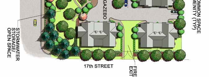
43 C. Site Plan 15th and Best Townhouses PUD PUD-5-06&S NOVEMBER 14, 2006 PAGE 7
44 D. "15th & Best Addition" Preliminary Plat PUD-5-06&S NOVEMBER 14, 2006 PAGE 8
45 E. Typical elevation 15th and Best Townhouses F. Typical building layout PUD-5-06&S NOVEMBER 14, 2006 PAGE 9

46 G. Average residential density in surrounding area: H. Applicant/ Jim and Nancy Hoffman Owner 8085 Salmon Berry Loop Hayden, ID I. Land uses in the area include residential - single-family, duplex, multifamily, commercial sales and service and vacant land. J. The subject property is vacant with a small number of significant Ponderosa Pine on the perimeter of the property. PERFORMANCE ANALYSIS: Planned Unit Development Findings: A. Finding #B8A: The proposal (is) (is not) in conformance with the Comprehensive Plan. 1. The subject property is within the existing city limits. 2. The City Comprehensive Plan Map designates this area as a Transition Area, as follows: Transition Areas: PUD-5-06&S NOVEMBER 14, 2006 PAGE 10
47 These areas represent the locations where the character of neighborhoods is in transition and, overall, should be developed with care. The street network, the number of building lots and general land use are planned to change greatly within the planning period. Page 28 All requests for zone changes, special use permits etc., will be made considering, but not limited to: 1. The individual characteristics of the site; 2. The existing conditions within the area, and 3. The goals of the community. Significant policies: 4C: New growth should enhance the quality and character of existing areas and the general community. 4C1: Development that proposes to increase the density of a given area may be allowed, provided that the increase maintains the character of the community. 4C3: Population growth should be compatible with preserving Coeur d Alene s character and quality of life. 4C5: New development should provide for bike paths and pedestrian walkways in accordance with the transportation plan and bike plan. 6A: Promote the orderly development of land use at locations that are compatible with public facilities and adjacent land uses. 14A3: All new developments must provide for immediate hook up to the sanitary sewer system. 23B1: New developments should be required to be within an existing sewage service area or provide a system that does not pollute the aquifer. 24C: Natural vegetative cover should remain as a dominant characteristic of Coeur d Alene. 42A2: Property rights of citizens should be protected in land use decisions. 46A: Provide for the safe and efficient circulation of vehicular traffic. 51A: Protect and preserve neighborhoods both old and new. 51A4: Trees should be preserved and protected by support of the Urban Forestry Program and indiscriminate removal discouraged. 51A5: Residential neighborhood land uses should be protected from intrusion of incompatible land uses and their effects. 62A: Examine all new developments for appropriateness in regard to the character of the proposed area. Inform developers of City requirements and encourage environmentally harmonious projects. Transportation Plan policies: The Transportation Plan is an addendum to the Comprehensive Plan and is a policy document that is intended to guide decisions that affect transportation issues. Its goal is to correct existing deficiencies and to anticipate, plan and provide for future transportation needs. PUD-5-06&S NOVEMBER 14, 2006 PAGE 11
48 31A: Develop an improved arterial system that integrates with existing street patterns. 33A: Safe vehicular and pedestrian circulation should be enhanced through careful design and active enforcement. 34A: Use existing street systems better. 34B: Reduce automobile dependency by providing bike paths and sidewalks. Coeur d Alene Bikeways Plan: MISSION: The essence of the City bicycle plan is to provide bike lanes on arterial and major collector streets to provide direct, continuous, and convenient transportation access to all parts of the community. GOAL: The plan should be used to require dedication of right-of-way with land partitions or street construction with all new subdivisions, roadway improvement projects and wherever possible with land use applications. This practical solution will provide bicycles and pedestrians with access into all residential, commercial and industrial areas of the community thereby encouraging use of bicycles for all type of trips, to decrease reliance on the automobile and to provide low cost transportation options for people without cars the young, the elderly, the poor and the disabled. To coordinate the City of Coeur d Alene Bicycle Plan with other cities, districts and state agencies to develop a regional network of bicycle transportation facilities. 3. Evaluation: The Planning Commission must determine, based on the information before them, whether the Comprehensive Plan policies do or do not support the request. Specific ways in which the policy is or is not supported by this request should be stated in the finding. B. Finding #B8B: The design and site planning (is) (is not) compatible with existing uses on adjacent properties. The request is adjacent to the Best Hills Meadows single-family subdivision to the east and a mixed single-family and duplex neighborhood to the north. While the proposed buildings in the development look like duplexes, the form of development is a type of single-family housing where the units are attached by a common wall to adjoining unit but the owner of each unit owns both the dwelling unit and the property it sits on. The two major differences with the surrounding area are that the development looks more like a duplex than a single-family neighborhood and the proposed density is 9.4 units per acre as opposed to approximately 2.8 units per acre for the surrounding single-family neighborhoods. The development, however, is below the maximum density allowed in an R-12 zone of 12 units per gross acre or for this parcel 34 units proposed and 45 units allowed by right. The development has one access on Best Avenue and an emergency only access on 17th Street, is designed to be compatible with a single-family neighborhood, has 1.1-acres of usable open space area, which is 31% of the 3.6 PUD-5-06&S NOVEMBER 14, 2006 PAGE 12
49 acre total area of the subject property and has two parking spaces per dwelling located in garages and 19 guest parking spaces spread throughout the development adjacent to the private streets. The development will be landscaped in accordance with the proposed PUD plan with a 6 foot perimeter fence. Evaluation: The Planning Commission must determine, based on the information before them, that the request is compatible with uses on adjacent properties in terms of density, design, parking, and open space and landscaping. C. Finding #B8C: The proposal (is) (is not) compatible with natural features of the site and adjoining properties. The subject property is relatively flat with no significant topographic features. There are, however, a number of significant Ponderosa Pines spread throughout the property. D. Finding #B8D: The location, design, and size of the proposal are such that the development (will) (will not) be adequately served by existing public facilities and services. See Preliminary plat finding #B8B. E. Finding #B8E: The proposal (does) (does not) provide adequate private common open space area, as determined by the Commission, no less than 10% of gross land area, free of buildings, streets, driveways or parking areas. The common open space shall be accessible to all users of the development and usable for open space and recreational purposes. The subject property for the PUD is 3.6 acres in size or 156,816 sq. ft. The required 10% open space requirement would be 15,681 sq. ft. and must be free of buildings, streets, driveways, parking areas, and swales and be accessible to all users of the development, and usable for open space and recreational purposes. There is 49,274 sq. ft. of usable open space or 31% of the entire property with the recreational amenities including 4 foot walking paths throughout the development, gazebo, open grassy areas and sitting areas. Evaluation: The Planning Commission must determine that the open space is accessible to all users of the development and usable for open space and recreational purposes. F. Finding #B8F: Off-street parking (does) (does not) provide parking sufficient for users of the development. The single-family residential parking requirement is two on-site parking spaces per unit or a total of 68 spaces. Each unit has a two car garage for 68 spaces plus 19 guest spaces for a total of 87 parking spaces. Evaluation: The number of spaces provided exceeds the minimum requirement of 68 parking spaces. PUD-5-06&S NOVEMBER 14, 2006 PAGE 13
50 G. Finding #B8G: That the proposal (does) (does not) provide for an acceptable method for the perpetual maintenance of all common property. A homeowner s association will own and maintain all common areas. Pursuant to Section of the Planned Unit Development Regulations, the Planning Commission can require the formation of a homeowners association to perpetually maintain all open space areas. The association shall be created in such a manner that owners of property shall automatically be members and shall be subject to assessments levied to maintain the open space. The association shall perpetually exist and can only be terminated by a majority vote of the members and consent of the City Council shall terminate it. Evaluation: As a condition of approval of the PUD, the Planning Commission should require the formation of a property owners association to ensure the maintenance of all common open space areas. H. Finding #B8H: That the proposal (would) (would not) adversely affect the surrounding neighborhood at this time with regard to traffic, neighborhood character (and) (or) existing land uses. The proposed development is a single-family attached development that is similar in character to surrounding residential uses and is located at the intersection of 15th Street (Minor arterial) and Best Avenue (local street). Evaluation: The proposed development appears to be compatible with the surrounding uses and would not adversely impact traffic on adjoining streets. Preliminary Plat Findings: I. Zoning: The subject property is zoned R-12 and will not change with this request. Residential uses allowed in this zone include single-family, duplexes and cluster housing up to 12 units/acre. The applicant is requesting 34 single-family lots with 34 units of single-family attached housing at an overall density of 9.4 units per gross acre, which is a lower density than 12 units/acre or 45 units allowed by right. The minimum lot size in the R-12 zone is 5500 sq. ft. per unit for single-family uses. With approval of the PUD, the lot sizes would be allowed below the 5500 sq. ft. minimum to 1,819 sq. ft. There would also be reduced building setbacks for each lot as follows: Front yard From 20-feet to 0-feet Side yards From 5/10-feet to 0-feet Rear yard From 25-feet to 0-feet The development is proposed on private streets, which would allow development with zero frontage rather than the 50 feet of frontage required on a public street. PUD-5-06&S NOVEMBER 14, 2006 PAGE 14
51 J. Finding #B8A: That all of the general preliminary plat requirements (have) (have not) been met, as attested to by the City Engineer. Per Gordon Dobler, City Engineer, the preliminary plat submitted contains all of the general information required by Section of the Municipal Code, General Requirements. K. Finding #B8B: That the provisions for streets, alleys, rights-of-way, easements, street lighting, fire protection, planting, drainage, and utilities (are) (are not) adequate where applicable. SEWER: Sanitary sewer is available to the proposed subdivision. There are sanitary main lines located in 15 th Street along the westerly boundary and Best Avenue along the southerly boundary of the subject property. Evaluation: The design layout for the subject property will require the applicant to construct a sanitary main extension from the existing sanitary facility located in Best Avenue to the south. The proposed layout for the sanitary sewer consists of a central main line with four (4) separate dead end legs running to the north to provide service for 2 4 units. This design will lead to odor problems caused by low flows through the dead end sanitary main lines and become a high maintenance issue requiring continual monitoring and flushing by the Wastewater Department personnel. One means of alleviating this situation would be to utilize a smaller diameter main line (6 ), however, the 10 States Standards which is the criteria by which City public mains are designed and built, requires that the minimum size pipe for public sewer be eight inch (8 ) in diameter. In order to reduce the disproportionate amount of maintenance that would be associated with this design, a redesign that will provide for some scouring of the sanitary main will be required. All public sanitary main lines will be required to have easements for access and maintenance dedicated over them, 20 wide for single and 30 wide for joint sewer and water. WATER: City water is available to the proposed subdivision. There is an existing twelve inch (12 ) A.C. water main in 15 th Street, a twelve inch (12 ) C-900 water main in Best Avenue and a six inch (6 ) A.C. water main in 17 th Street. Evaluation: These lines are adequate to serve the proposed subdivision. It will be required that the developer construct a water main loop connecting the existing mains in 17 th Street and Best Avenue. It would also be desirable for enhanced flow capacity and future maintenance, to make a secondary loop to the existing water main in 15 th Street. To facilitate maintenance and insure sufficient water flows and fire protection into the four proposed dead ends, the developer will be required to install fire hydrants at the northerly ends and install eight inch (8 ) mains to them. Looping of the dead end PUD-5-06&S NOVEMBER 14, 2006 PAGE 15
52 STORMWATER: lines would also facilitate the flows and lessen maintenance issues for the City Water Department. All public water main lines will be required to have easements for access and maintenance dedicated over them, 20 wide for single and 30 wide for joint sewer and water. Easements over the water mains will be required to extend to encompass the installed fire hydrants. City Code requires a stormwater management plan to be submitted and approved prior to any construction activity on the site. Evaluation: A detailed stormwater plan submittal is a requirement of the site design and is required to be submitted with the on-site civil design for the subject property. It will be reviewed at that time for conformance with the City requirements. The on-site drainage will not be allowed to utilize the existing City drainage facility located on the subject property. The existing City stormwater swale located on the subject property may be reconfigured to facilitate the development; however, the capacity of the swale cannot be lessened. TRAFFIC: The ITE Trip Generation Manual estimates the project will generate approximately 8.9 trips per day during the peak hour periods (utilizing an average peak hour trip factor of 0.52) Evaluation: Best Avenue, the adjacent street which will serve as the point of ingress and egress, is controlled by a signalized intersection and will accommodate the additional traffic volume. Due to the proximity to the 15 th /Best intersection and conflicts with the southbound, left turn lane, access onto 15 th Street if proposed, will be restricted to right turn egress, northbound only. No ingress traffic would be allowed. STREETS: The proposed subdivision is bordered by 15 th Street on the West, Best Avenue on the south and 17 th Street on the east. The current right-of-way width s all meet City standards. Evaluation: Both 15 th Street and Best Avenue are fully developed street sections, however, sidewalk needs to be installed on the Best Avenue frontage. Seventeenth Street, which is considered a fire lane, barricaded at both ends between Best and Haycraft Avenues has only a paved surface. The interior streets have been proposed to be private and twenty four feet (24 ) wide with a four foot (4 ) pedestrian walking lane for a twenty eight foot (28 ) width. PUD-5-06&S NOVEMBER 14, 2006 PAGE 16
53 Evaluation: The proposed interior roadway will suffice in the proposed configuration. The addition of the four foot (4 ) walkway will allow sufficient width to meet City Fire Department width criteria. The roadway in the subject development will be private, owned and maintained by the requisite homeowners association. Evaluation: The roadways will be required to posted with names that have been previously approved by the Kootenai County Planning Department, and, have the names installed per City Standards with white lettering on a blue background. Also, since the roadway is private, it will be required to be designated as a Tract on the subdivision plat document. FIRE PROTECTION: Due to the number of units (17 duplex type structures, 34 units), secondary access for emergency vehicles is required. The Developer will be required to install gates, approved by the City Fire Department at the secondary access point on the easterly boundary, and, at the 17 th Street/Best Avenue connection. All costs associated with these gates will be the responsibility of the developer. APPLICABLE CODES AND POLICIES: UTILITIES: 1. All proposed utilities within the project shall be installed underground. 2, All water and sewer facilities shall be designed and constructed to the requirements of the City of Coeur d Alene. Improvement plans conforming to City guidelines shall be submitted and approved by the City Engineer prior to construction. 3. All water and sewer facilities servicing the project shall be installed and approved prior to issuance of building permits. 4. All required utility easements shall be dedicated on the final plat. STREETS: 5. Street improvement plans conforming to City guidelines shall be submitted and approved by the City Engineer prior to construction. 6. All required street improvements shall be constructed prior to issuance of building permits. 7. An encroachment permit shall be obtained prior to any work being performed in the existing right-of-way. STORMWATER: 8. A stormwater management plan shall be submitted and approved prior to start of any construction. The plan shall conform to all requirements of the City. PUD-5-06&S NOVEMBER 14, 2006 PAGE 17
54 GENERAL 9. The final plat shall conform to the requirements of the City. 10. The Covenants, Conditions, and Restrictions and/or Articles of Incorporation of the homeowners association shall be subject to review for compliance with the conditions herein by the City Attorney. Submitted by Chris Bates, Project Manager FIRE: The standard Fire Dept. issues of access, water supplies, etc. will be addressed at the plan review phase. However, the bigger issue is the ability of the Fire Dept. (and other city services) to meet the increased demands on services such developments bring to the table, without increasing personnel and equipment. Submitted by Dan Cochran, Deputy Fire Chief POLICE: I have no comments at this time. Submitted by Captain Steve Childers L. Finding #B8C: That the preliminary plat (is) (is not) in conformance with the Comprehensive Plan as follows: See Finding #B8A in Planned Unit Development Findings. M. Finding #B8D: That the public interest (will) (will not) be served. The subject property is within the corporate limits and will create a 34-lot subdivision on private streets that will provide an alternative form of housing for the Coeur d'alene area. Evaluation: The Planning Commission must determine, based on the information before them, whether the request will or will not serve the public interest. Specific ways in which this request does or does not should be stated in the finding. N. Finding #B8E: That all of the required engineering elements of the preliminary plat (have) (have not) been met, as attested to by the City Engineer. A preliminary utility design was submitted indicating that all proposed lots could be served. O. Finding #B8F: That the lots proposed in the preliminary plat (do) (do not) meet the requirements of the applicable zoning district. If the requested PUD is approved, a new set of development standards would be created for the items below. Except for these modifications, all other applicable development standards in the R-12 zone would apply to this project. Zoning Ordinance: PUD-5-06&S NOVEMBER 14, 2006 PAGE 18
55 1. All proposed lots are 1,819 sq. ft. which, are below the minimum lot size requirement of 5,500 sq. ft per unit for single-family dwellings in an R-12 zone. 2. Zero frontage on a public street because the proposed development is on private streets 3. Reduce building setbacks: Front yard From 20-feet to 0-feet Side yards From 5/10-feet to 0-feet Rear yard From 25-feet to 0-feet 4. Reduce driveway standards, as follows: Reduce driveway length between garage door and front property line from 20 feet to 0 feet. 5. Waive the one tree per lot street tree requirement for single-family and duplex uses. Subdivision Ordinance: 6. Private streets: 24-foot paved street, curb & gutter, 5-foot sidewalks meandering throughout the development and 21 visitor parking spaces at various locations along the private streets. Tract A on subdivision plat accommodates the streets, curb and gutter, varies in width between 16 feet and 40 feet and is common area owned by the homeowner's association. (The standard street is 60-feet of right-of-way, 36-foot wide paved street with curb, gutter and 5-foot sidewalks on both sides). Evaluation: The Planning Commission must determine if the new set of standards requested through the PUD are appropriate in the ec- 17L zoning district. P. Finding #B9: That the proposal (would) (would not) adversely affect the surrounding neighborhood at this time with regard to traffic, neighborhood character, and existing land uses. See PUD finding B8H. Q. Proposed conditions: 1. Formation of a homeowners association with CC&R s that includes detailed maintenance responsibilities of all private infrastructure (roads, drainage structures, street lighting, and all open space areas etc.), prior to recordation of the final plat. 2. Redesign the sanitary sewer to reduce or eliminate the dead end lines and increase the flow necessary to achieve scouring in the sanitary mains. PUD-5-06&S NOVEMBER 14, 2006 PAGE 19
56 3. Construct looping connections for the water main between 17 th Street and Best Avenue, with a secondary connection to 15 th Street. 4. Install fire hydrants at the end of the dead end legs to facilitate the water system and fire protection. Water mains to these hydrants will be required to be eight inch (8 ). 5. The existing City stormwater swale situated in an easement in the southeast corner of the subject property can be reconfigured if necessary; however, swale capacity cannot be diminished. 6. Access if proposed on to 15 th Street would be restricted to egress and northbound only. No ingress or southbound egress turning movements would be allowed. 7. Sidewalk installation is required along the Best Avenue frontage. 8. The interior private roadway may be twenty four feet (24 ) in width with a four foot (4 ) pedestrian path, for a total twenty eight foot (28 ) width. 9. The private roadway shall have a tract designation and shall be maintained by the homeowners association of the development. 10. The developer shall install access gates at the easterly emergency access point to the site, and, at the 17 th /Best connection. All costs will be the responsibility of the developer. 11. Access and maintenance easements will be required to be dedicated over the public sewer and water mains located on the subject property that are not situated within public right-of-way. Easement widths will be twenty feet (20 ) for single utility and thirty feet (30 ) for double utility. R. Ordinances and Standards Used In Evaluation: ACTION ALTERNATIVES: Comprehensive Plan - Amended Transportation Plan Municipal Code. Idaho Code. Wastewater Treatment Facility Plan. Water and Sewer Service Policies. Urban Forestry Standards. Transportation and Traffic Engineering Handbook, I.T.E. Manual on Uniform Traffic Control Devices. Coeur d Alene Bikeways Plan Kootenai County Assessor's Department property records The Planning Commission must consider this request and make appropriate findings to approve, deny or deny without prejudice. The findings worksheet is attached. [F:pcstaffrptsPUD506&S1206] PUD-5-06&S NOVEMBER 14, 2006 PAGE 20
57
58
59
60
61
62
63
64
65
66
67
68
69
70
71
72 COEUR D'ALENE PLANNING COMMISSION FINDINGS AND ORDER A. INTRODUCTION This matter having come before the Planning Commission on November 14, 2006, and there being present a person requesting approval of ITEM PUD-5-06 a request for a planned unit development known as 15th and Best Townhomes PUD LOCATION: APPLICANT: Location +/- 3.6-acre parcel at the northeast corner of 15th Street and Best Avenue Jim & Nancy Hoffman B. FINDINGS: JUSTIFICATION FOR THE DECISION/CRITERIA, STANDARDS AND FACTS RELIED UPON (The Planning Commission may adopt Items B1-through7.) B1. That the existing land uses are residential - single-family, duplex, multi-family, commercial sales and service and vacant land. B2. That the Comprehensive Plan Map designation is Transition B3. That the zoning is R-12 (Residential at 12 units/acre) B4. That the notice of public hearing was published on October 28, 2006, and November 7, 2006 which fulfills the proper legal requirement. B5. That the notice of public hearing was posted on the property on November 3, 2006, which fulfills the proper legal requirement. B6. That 96 notices of public hearing were mailed to all property owners of record within threehundred feet of the subject property on October 27, 2006, and responses were received: in favor, opposed, and neutral. B7. That public testimony was heard on November 14, B8. Pursuant to Section , Planned Unit Development Review Criteria, a planned unit development may be approved only if the proposal conforms to the following criteria to the satisfaction of the Planning Commission: PLANNING COMMISSION FINDINGS: PUD-5-06 NOVEMBER 14, 2006 PAGE 1
73 B8A. The proposal (is) (is not) in conformance with the Comprehensive Plan. This is based upon the following policies: B8B. The design and site planning (is) (is not) compatible with existing uses on adjacent properties. This is based on Criteria to consider for B8B: 1. Density 6. Open space 2. Architectural style 7. Landscaping 3. Layout of buildings 4. Building heights & bulk 5. Off-street parking B8C The location, design, and size of the proposal are such that the development (will) (will not) be adequately served by existing public facilities and services. This is based on Criteria to consider for B8C: 1. Is there water available to meet the minimum requirements for domestic consumption & fire flow? 2. Can sewer service be provided to meet minimum requirements? 3. Can the existing street system accommodate the anticipated traffic to be generated by this development? 4. Can police and fire provide reasonable service to the property? PLANNING COMMISSION FINDINGS: PUD-5-06 NOVEMBER 14, 2006 PAGE 2
74 B8D The proposal (does) (does not) provide adequate private common open space area, as determined by the Commission, no less than 10% of gross land area, free of buildings, streets, driveways or parking areas. The common open space shall be accessible to all users of the development and usable for open space and recreational purposes. This is based on B8E Off-street parking (does)(does not) provide parking sufficient for users of the development. This is based on B8F That the proposal (does) (does not) provide for an acceptable method for the perpetual maintenance of all common property. This is based on B8G That the proposal (would) (would not) adversely affect the surrounding neighborhood at this time with regard to traffic, neighborhood character (and) (or) existing land uses because Criteria to consider for B8G: 1. Will the change in traffic flow adversely affect the livability of the surrounding neighborhood? 2. Does the proposed development fit with the surrounding area in terms of density, layout & appearance? 3. Is the proposed development compatible with the existing land use pattern? i.e. residential, commercial, residential w churches & schools PLANNING COMMISSION FINDINGS: PUD-5-06 NOVEMBER 14, 2006 PAGE 3
75 C. ORDER: CONCLUSION AND DECISION The Planning Commission, pursuant to the aforementioned, finds that the request of JIM AND NANCY HOFFMAN for approval of the planned unit development, as described in the application should be (approved) (denied) (denied without prejudice). Special conditions applied are: Motion by seconded by to adopt the foregoing Findings and Order. ROLL CALL: Commissioner Bowlby Commissioner George Commissioner Jordan Commissioner Messina Commissioner Rasor Commissioner Souza Chairman Bruning Voted Voted Voted Voted Voted Voted Voted (tie breaker) Commissioners were absent. Motion to carried by a to vote. CHAIRMAN JOHN BRUNING PLANNING COMMISSION FINDINGS: PUD-5-06 NOVEMBER 14, 2006 PAGE 4
76
77 COEUR D'ALENE PLANNING COMMISSION FINDINGS AND ORDER A. INTRODUCTION This matter having come before the Planning Commission on November 14, 2006, and there being present a person requesting approval of ITEM S-12-06: a request for preliminary plat approval of 15th and Best Town homes, a 34-lot condominium subdivision on private streets in the R-12 (Residential at 12 units/acre) zoning district. LOCATION: APPLICANT: Location +/- 3.6-acre parcel at the northeast corner of 15th Street and Best Avenue Jim & Nancy Hoffman B. FINDINGS: JUSTIFICATION FOR THE DECISION/CRITERIA, STANDARDS AND FACTS RELIED UPON (The Planning Commission may adopt Items B1 to B7.) B1. That the existing land uses are residential - single-family, duplex, multi-family, commercial sales and service and vacant land. B2. That the Comprehensive Plan Map designation is Transition B3. That the zoning is R-12 (Residential at 12 units/acre) B4. That the notice of public hearing was published on October 28, 2006, and November 7, 2006 which fulfills the proper legal requirement. B5. That the notice of public hearing was posted on the property on November 3, 2006, which fulfills the proper legal requirement. B6. That 96 notices of public hearing were mailed to all property owners of record within three-hundred feet of the subject property on October 27, 2006, and responses were received: in favor, opposed, and neutral. B7. That public testimony was heard on November 14, B8. Pursuant to Section A.1, Preliminary Plats: In order to approve a preliminary plat, the Planning Commission must make the following findings:
78 B8A. That all of the general preliminary plat requirements (have) (have not) been met, as attested to by the City Engineer. This is based on B8B. That the provisions for streets, alleys, rights-of-way, easements, street lighting, fire protection, planting, drainage, and utilities (are) (are not) adequate where applicable. This is based on B8C. That the preliminary plat (is) (is not) in conformance with the Comprehensive Plan as follows: B8D. That the public interest (will) (will not) be served based on B8E. That all of the required engineering elements of the preliminary plat (have) (have not) been met, as attested to by the City Engineer. This is based on B8F. That the lots proposed in the preliminary plat (do) (do not) meet the requirements of the applicable zoning district for the following reasons: B9. That the proposal (would) (would not) adversely affect the surrounding neighborhood at this time with regard to traffic, neighborhood character, and existing land uses because C. ORDER: CONCLUSION AND DECISION The Planning Commission, pursuant to the aforementioned, finds that the request of JIM AND NANCY HOFFMAN for preliminary plat of approval as described in the application should be (approved) (denied) (denied without prejudice). Special conditions applied to the motion are: PLANNING COMMISSION FINDINGS: S NOVEMBER 14, 2006 PAGE 2
79 Motion by, seconded by, to adopt the foregoing Findings and Order. ROLL CALL: Commissioner Bowlby Commissioner George Commissioner Jordan Commissioner Messina Commissioner Rasor Commissioner Souza Chairman Bruning Voted Voted Voted Voted Voted Voted Voted (tie breaker) Commissioners were absent. Motion to carried by a to vote. CHAIRMAN JOHN BRUNING PLANNING COMMISSION FINDINGS: S NOVEMBER 14, 2006 PAGE 3

80 PLANNING COMMISSION STAFF REPORT FROM: JOHN J. STAMSOS, ASSOCIATE PLANNER DATE: NOVEMBER 14, 2006 SUBJECT: S LOT ICE PLANT PRELIMINARY PLAT SUBDIVISION LOCATION +/ ACRE PARCEL AT 311 SOUTH 11TH STREET DECISION POINT: A. Dave Schreiber, Ice Plant Development, Inc. is requesting Preliminary Plat approval of Ice Plant, a 24-lot subdivision in the R-12 (Residential at12 units/acre) Downtown East Infill Overlay zoning district. This is a 24 unit attached single-family zero lot line townhouse development, currently under construction, consisting of two 12-unit buildings with each dwelling unit on a separate lot with a 24 foot wide access and utility easement centered on the interior property lines to access the parking areas for each dwelling unit. SITE PHOTOS: A. Aerial photo of surrounding area. S NOVEMBER 14, 2006 PAGE 1
PLANNING COMMISSION AGENDA COEUR D ALENE PUBLIC LIBRARY LOWER LEVEL, COMMUNITY ROOM 702 E. FRONT AVENUE
 PLANNING COMMISSION AGENDA COEUR D ALENE PUBLIC LIBRARY LOWER LEVEL, COMMUNITY ROOM 702 E. FRONT AVENUE OCTOBER 13, 2009 THE PLANNING COMMISSION S VISION OF ITS ROLE IN THE COMMUNITY The Planning Commission
PLANNING COMMISSION AGENDA CITY COUNCIL CHAMBERS JULY 11, 2006 THE PLANNING COMMISSION S VISION OF ITS ROLE IN THE COMMUNITY
 PLANNING COMMISSION AGENDA CITY COUNCIL CHAMBERS JULY 11, 2006 THE PLANNING COMMISSION S VISION OF ITS ROLE IN THE COMMUNITY The Planning Commission sees its role as the preparation and implementation
PLANNING COMMISSION AGENDA CITY COUNCIL CHAMBERS AUGUST 28, 2007 THE PLANNING COMMISSION S VISION OF ITS ROLE IN THE COMMUNITY
 PLANNING COMMISSION AGENDA CITY COUNCIL CHAMBERS AUGUST 28, 2007 THE PLANNING COMMISSION S VISION OF ITS ROLE IN THE COMMUNITY The Planning Commission sees its role as the preparation and implementation
PLANNING COMMISSION AGENDA CITY COUNCIL CHAMBERS MAY 9, 2006 THE PLANNING COMMISSION S VISION OF ITS ROLE IN THE COMMUNITY
 PLANNING COMMISSION AGENDA CITY COUNCIL CHAMBERS MAY 9, 2006 THE PLANNING COMMISSION S VISION OF ITS ROLE IN THE COMMUNITY The Planning Commission sees its role as the preparation and implementation of
PLANNING COMMISSION AGENDA COEUR D ALENE PUBLIC LIBRARY LOWER LEVEL, COMMUNITY ROOM 702 E. FRONT AVENUE. June 9, 2015
 PLANNING COMMISSION AGENDA COEUR D ALENE PUBLIC LIBRARY LOWER LEVEL, COMMUNITY ROOM 702 E. FRONT AVENUE June 9, 2015 THE PLANNING COMMISSION S VISION OF ITS ROLE IN THE COMMUNITY The Planning Commission
PLANNED UNIT DEVELOPMENTS
 PLANNED UNIT DEVELOPMENTS SECTION 9.01 DESCRIPTION AND PURPOSE. A. The purpose of a planned unit development (PUD) is to permit greater flexibility in development than is generally possible under standard
Appendix J - Planned Unit Development (PUD)
") Appendix J - Planned Unit Development (PUD) Intent and Purpose The purpose of the PUD is: 1. To provide development that is consistent with the Comprehensive Land Use Plan and promote the goals and objectives
Appendix J - Planned Unit Development (PUD) Intent and Purpose The purpose of the PUD is: 1. To provide development that is consistent with the Comprehensive Land Use Plan and promote the goals and objectives
The following regulations shall apply in the R-E District:
 "R-E" RESIDENTIAL ESTATE DISTRICT (8/06) The following regulations shall apply in the R-E District: 1. Uses Permitted: The following uses are permitted. A Zoning Certificate may be required as provided
PLANNING COMMISSION AGENDA COEUR D ALENE PUBLIC LIBRARY LOWER LEVEL, COMMUNITY ROOM 702 E. FRONT AVENUE OCTOBER 8, 2013
 PLANNING COMMISSION AGENDA COEUR D ALENE PUBLIC LIBRARY LOWER LEVEL, COMMUNITY ROOM 702 E. FRONT AVENUE OCTOBER 8, 2013 THE PLANNING COMMISSION S VISION OF ITS ROLE IN THE COMMUNITY The Planning Commission
Article Optional Method Requirements
 Article 59-6. Optional Method Requirements [DIV. 6.1. MPDU DEVELOPMENT IN RURAL RESIDENTIAL AND RESIDENTIAL ZONES Sec. 6.1.1. General Requirements... 6 2 Sec. 6.1.2. General Site and Building Type Mix...
Cover Letter with Narrative Statement
 Cover Letter with Narrative Statement March 31, 2017 rev July 27, 2017 RE: Rushton Pointe Residential Planned Unit Development Application for Public Hearing for RPUD Rezone PL2015 000 0306 Mr. Eric Johnson,
Planned Unit Development (PUD). Sections:
. Sections:") Chapter 19.07. Planned Unit Development (PUD). Sections: 19.07.01. Purpose. 19.07.02. PUD Definition and Design Compatibility. 19.07.03. General PUD Standards. 19.07.04. Underlying Zones. 19.07.05. Permitted
Chapter 19.07. Planned Unit Development (PUD). Sections: 19.07.01. Purpose. 19.07.02. PUD Definition and Design Compatibility. 19.07.03. General PUD Standards. 19.07.04. Underlying Zones. 19.07.05. Permitted
1. Roll Call. 2. Minutes a. September 24, 2018 Special Joint Meeting with Clay County Planning Commission. 3. Adoption of the Agenda
 1. Roll Call City of Vermillion Planning Commission Agenda 5:30 p.m. Regular Meeting Tuesday, October 9, 2018 City Council Chambers 2 nd Floor City Hall 25 Center Street Vermillion, SD 57069 2. Minutes
FINAL DRAFT 12/1/16, Rev. to 7/18/17
 FINAL DRAFT 12/1/16, Rev. to 7/18/17 (As Adopted 8/8/17 Effective 9/1/17) SHELTON PLANNING AND ZONING COMMISSION Proposed Amendments to Zoning Regulations I. Amend Section 23 PERMITTED USES by inserting
4.2 RESIDENTIAL ZONING DISTRICTS
 4.2 RESIDENTIAL ZONING DISTRICTS A. Purpose: To define regulations and standards for each residential zoning district in the City. The following sections identify uses, regulations, and performance standards
CHAPTER 14 PLANNED UNIT DEVELOPMENTS
 9-14-1 9-14-1 CHAPTER 14 PLANNED UNIT DEVELOPMENTS SECTION: 9-14-1: Purpose 9-14-2: Governing Provisions 9-14-3: Minimum Area 9-14-4: Uses Permitted 9-14-5: Common Open Space 9-14-6: Utility Requirements
PALM BEACH COUNTY PLANNING, ZONING AND BUILDING DEPARTMENT ZONING DIVISION
 PALM BEACH COUNTY PLANNING, ZONING AND BUILDING DEPARTMENT ZONING DIVISION Application No.: CA-2012-00688 Control No.: 2011-00552 Applicant: Garry Bernardo Owners: Garry Bernardo Agent: Frogner Consulting,
MINUTES OF THE PLANNING AND ZONING COMMISSION CITY OF HAYDEN, KOOTENAI COUNTY, IDAHO. September 17, 2018
 MINUTES OF THE PLANNING AND ZONING COMMISSION CITY OF HAYDEN, KOOTENAI COUNTY, IDAHO September 17, 2018 Regular Meeting: 5:00 PM Council Chambers Hayden City Hall, 8930 N. Government Way, Hayden, ID 83835
Financial Impact Statement There are no immediate financial impacts associated with the adoption of this report.
 STAFF REPORT Planning and Development Department Subject: Application by RYC Property to rezone a portion of lands on John Murray Dr. and Megan Lynn Dr. from R2 to R3 and to enter into a Development Agreement
PLANNING COMMISSION STAFF REPORT. Merrimac PLNSUB Planned Development 38 West Merrimac November 9, Request. Staff Recommendation
 PLANNING COMMISSION STAFF REPORT Merrimac PLNSUB2011-00374 Planned Development 38 West Merrimac November 9, 2011 Planning and Zoning Division Department of Community and Economic Development Applicant:
UPPER MOUNT BETHEL TOWNSHIP NORTHAMPTON COUNTY, PENNSYLVANIA
 UPPER MOUNT BETHEL TOWNSHIP NORTHAMPTON COUNTY, PENNSYLVANIA JOINDER DEED / LOT CONSOLIDATION TOWNSHIP REVIEW PROCESS When accepting proposed Joinder Deeds / Lot Consolidations, review the Joinder Deed
1. Cuyler-Brownsville planned neighborhood conservation (P-N-C) districtphase I (section ). (2) Single-family semiattached dwellings;
 districtphase I (section ). (2) Single-family semiattached dwellings;") Sec. 8-3035. Planned unit development multifamily (PUD-M). A. Purpose. The PUD-M district is intended to allow a variety of residential development including single-family residential, two-family residential,
Sec. 8-3035. Planned unit development multifamily (PUD-M). A. Purpose. The PUD-M district is intended to allow a variety of residential development including single-family residential, two-family residential,
ARTICLE 14 PLANNED UNIT DEVELOPMENT (PUD) DISTRICT
 DISTRICT") ARTICLE 14 PLANNED UNIT DEVELOPMENT (PUD) DISTRICT Section 14.01 Intent. It is the intent of this Article to allow the use of the planned unit development (PUD) process, as authorized by the Michigan Zoning
ARTICLE 14 PLANNED UNIT DEVELOPMENT (PUD) DISTRICT Section 14.01 Intent. It is the intent of this Article to allow the use of the planned unit development (PUD) process, as authorized by the Michigan Zoning
PALM BEACH COUNTY PLANNING, ZONING AND BUILDING DEPARTMENT ZONING DIVISION
 PALM BEACH COUNTY PLANNING, ZONING AND BUILDING DEPARTMENT ZONING DIVISION Application No.: Z/CA-2013-00493 Application Name: Trails Charter School Control No.: 2013-00085 Applicant: MG3 ALF Military LLC
Planning Department Oconee County, Georgia
 Planning Department Oconee County, Georgia STAFF REPORT REZONE CASE #: 6985 DATE: October 31, 2016 STAFF REPORT BY: Andrew C. Stern, Planner APPLICANT NAME: Williams & Associates, Land Planners PC PROPERTY
City of Poulsbo PLANNING COMMISSION
 City of Poulsbo PLANNING COMMISSION Tuesday, April 5, 2016 MINUTES Members Present James Thayer (JT), Bob Nordnes (BN), Ray Stevens (RS), Kate Nunes (KN) Members Absent Shane Skelley (SS), Gordon Hanson
AGENDA. 2. Review of Agenda by the Board and Addition of items of New Business to the Agenda for Consideration by the Board
 BOARD OF ADJUSTMENT/APPEALS REGULAR MEETING October 24, 2013 7:00 P.M. Town Board Chambers, 301 Walnut Street, Windsor, CO 80550 The Town of Windsor will make reasonable accommodations for access to Town
SECTION 10.7 R-PUD (RESIDENTIAL PLANNED UNIT DEVELOPMENT) ZONE
 ZONE") Article X Zones 10-20 SECTION 10.7 R-PUD (RESIDENTIAL PLANNED UNIT DEVELOPMENT) ZONE A. PURPOSE AND INTENT: The R-PUD Residential PUD Zone is intended to provide alternative, voluntary zoning procedures
Article X Zones 10-20 SECTION 10.7 R-PUD (RESIDENTIAL PLANNED UNIT DEVELOPMENT) ZONE A. PURPOSE AND INTENT: The R-PUD Residential PUD Zone is intended to provide alternative, voluntary zoning procedures
ASHLAND PLANNING COMMISSION REGULAR MEETING AUGUST 9, 2011 AGENDA
 Note: Anyone wishing to speak at any Planning Commission meeting is encouraged to do so. If you wish to speak, please rise and, after you have been recognized by the Chair, give your name and complete
MINUTES JOINT MEETING LINCOLN COUNTY and SIOUX FALLS PLANNING COMMISSIONS 7:00 pm August 10, 2011
 MINUTES JOINT MEETING LINCOLN COUNTY and SIOUX FALLS PLANNING COMMISSIONS 7:00 pm August 10, 2011 Commissioners Room - Lincoln County Court House A joint meeting of the Lincoln County and Sioux Falls Planning
1. The meeting was called to Order with Roll Call by Chairman Richard Hemphill.
 PLANNING COMMISSION City Hall, 32905 W. 84 th Street 6:00 PM., August 22nd, 2017 MINUTES 1. The meeting was called to Order with Roll Call by Chairman Richard Hemphill. 2. Roll Call: Allenbrand Absent
Operating Standards Attachment to Development Application
 Planning & Development Services 2255 W Berry Ave. Littleton, CO 80120 Phone: 303-795-3748 Mon-Fri: 8am-5pm www.littletongov.org Operating Standards Attachment to Development Application 1 PLANNED DEVELOPMENT
Joint City-County Planning Commission of Barren County, Kentucky. November 18, 2013
 Joint City-County Planning Commission of Barren County, Kentucky The Joint City-County Planning Commission of Barren County, Kentucky met in regular session on Monday, at 7:00 PM in the Glasgow City Building.
LETTER OF APPLICATION
 Description of Proposed Land Division: LETTER OF APPLICATION The proposed land division would split a 1.94 acres rectangular lot into two lots. The general configuration would have one lot in front of
REPORT TO THE SHELBY COUNTY PLANNING COMMISSION From the Department of Development Services Planning Services. February 4, 2019
 REPORT TO THE SHELBY COUNTY PLANNING COMMISSION From the Department of Development Services Planning Services February 4, 2019 Case No. Request for Rezoning Approval From E-1 to E-2 SD This is a request
Organized with a "core" curriculum (the first five modules) and "electives" (the remaining modules in the program.
 and electives (the remaining modules in the program.") Introduction Sponsored by The North Carolina Chapter - American Planning Association These materials are the result of an effort by volunteer members of the North Carolina Chapter of the American Planning
Introduction Sponsored by The North Carolina Chapter - American Planning Association These materials are the result of an effort by volunteer members of the North Carolina Chapter of the American Planning
RP-2, RP-3, RP-4, AND RP-5 PLANNED RESIDENTIAL DISTRICTS
 6.10 - RP-2, RP-3, RP-4, AND RP-5 PLANNED RESIDENTIAL DISTRICTS 6.10.1 GENERAL DESCRIPTION: 6.10.1.1 The regulations established in this Section are intended to provide optional methods of land development
PLANNED UNIT DEVELOPMENT & SUBDIVISION STAFF REPORT Date: April 18, 2019
 PLANNED UNIT DEVELOPMENT & SUBDIVISION STAFF REPORT Date: April 18, 2019 DEVELOPMENT NAME SUBDIVISION NAME Springhill Village Subdivision Springhill Village Subdivision LOCATION 4350, 4354, 4356, 4358,
AGENDA ITEM 1. Call to Order, Roll Call and Approval of Minutes.
 PC00-0 0 0 0 WAYZATA PLANNING COMMISSION MEETING MINUTES March, 0 AGENDA ITEM. Call to Order, Roll Call and Approval of Minutes. Chair Gonzalez called the meeting to order at :00 p.m. Present at roll call
Chapter Planned Residential Development Overlay
 Chapter 19.29 Planned Residential Development Overlay Sections 010 Purpose 020 Scope 030 Definitions 030 Minimum Size 040 Allowable Uses 050 Minimum Development Standards 060 Density Bonus 070 Open Space
INDIAN RIVER COUNTY, FLORIDA. The Honorable Members of the Planning and Zoning Commission DEPARTMENT HEAD CONCURRENCE
 Public Hearing Legislative INDIAN RIVER COUNTY, FLORIDA M E M O R A N D U M TO: The Honorable Members of the Planning and Zoning Commission DEPARTMENT HEAD CONCURRENCE Robert M. Keating, AICP; Community
EDMOND PLANNING COMMISSION 20 S. Littler, Edmond, Oklahoma Tuesday, May 6, :30 p.m.
 City of Edmond NOTICE OF PUBLIC MEETING The City of Edmond encourages participation from all its citizens. If participation at any Public meeting is not possible due to a disability, notification to the
PLANNING COMMISSION AGENDA COEUR D ALENE PUBLIC LIBRARY LOWER LEVEL, COMMUNITY ROOM 702 E. FRONT AVENUE JUNE 13, 2017
 PLANNING COMMISSION AGENDA COEUR D ALENE PUBLIC LIBRARY LOWER LEVEL, COMMUNITY ROOM 702 E. FRONT AVENUE JUNE 13, 2017 THE PLANNING COMMISSION S VISION OF ITS ROLE IN THE COMMUNITY The Planning Commission
Subdivision and Land Development Regulations. Jefferson County, West Virginia
 Subdivision and Land Development Regulations Jefferson County, West Virginia Adopted October 9, 2008 Amended September 29, 2016 Amendment Reference This document contains additions and amendments approved
Box Elder County Land Use Management & Development Code Article 3: Zoning Districts
 Chapter 3-6 Mobile Homes, Mobile Home Subdivisions, & Recreational Vehicle Parks Box Elder Zoning Ordinance as Adopted October 2007 Sections. 3-6-010. Purpose and Intent. 3-6-020. Conditional Use Permit
PLANNING AND ZONING DEPARTMENT
 Town of Minturn Development Review Process: Guide To Planned Unit Developments (Concept Plan) This guide describes the Planned Unit Development Process. This guide should be utilized in conjunction with
PLAINFIELD CHARTER TOWNSHIP COMMUNITY DEVELOPMENT DEPARTMENT PLANNING, ZONING & BUILDING SERVICES MEMORANDUM
 PLAINFIELD CHARTER TOWNSHIP COMMUNITY DEVELOPMENT DEPARTMENT PLANNING, ZONING & BUILDING SERVICES 6161 BELMONT AVENUE N.E. BELMONT, MI 49306 PHONE 616-364-1190 FAX: 616-364-1170 www.plainfieldchartertwp.org
DEVELOPMENT DEPARTMENT STAFF REPORT THE PARK AT 5 TH
 DEVELOPMENT DEPARTMENT STAFF REPORT ARB Meeting Date: July 3, 2018 Item #: _PZ2018-293_ THE PARK AT 5 TH Request: Site Address: Project Name: Parcel Number: Applicant: Proposed Development: Current Zoning:
Community Dev. Coord./Deputy City Recorder
 1 2 3 4 5 6 7 8 9 10 11 12 13 14 15 16 17 18 19 20 21 22 23 24 25 26 27 28 29 30 31 32 33 34 35 36 37 38 39 40 41 42 43 44 45 46 NORTH OGDEN PLANNING COMMISSION MEETING MINUTES December 18, 2013 The North
2. Rezone a portion of the lot from R2 (Small Lot Residential) to RD2 (Duplex: Housing Lane).
 to RD2 (Duplex: Housing Lane).") Public Notice September 6, 2018 Subject Property Subject Property: 337 Hastings Ave Lot 24, District Lot 1, Group 7, Similkameen Division Yale (Formerly Yale-Lytton) District, Plan 932 Application: The
Public Notice September 6, 2018 Subject Property Subject Property: 337 Hastings Ave Lot 24, District Lot 1, Group 7, Similkameen Division Yale (Formerly Yale-Lytton) District, Plan 932 Application: The
PLANNED UNIT DEVELOPMENT & SUBDIVISION STAFF REPORT August 18, 2016
 PLANNED UNIT DEVELOPMENT & SUBDIVISION STAFF REPORT August 18, 2016 DEVELOPMENT NAME SUBDIVISION NAME Mullinax Ford Subdivision Mullinax Ford Subdivision LOCATION CITY COUNCIL DISTRICT District 6 Southeast
MINUTES ADJUSTMENTS AND APPEALS BOARD. April 3, 2013
 MINUTES ADJUSTMENTS AND APPEALS BOARD April 3, 2013 A Public Hearing of the City of South Daytona s Adjustments and Appeals Board was called to order in the South Daytona City Council Chambers, 1672 South
Community Development Department 333 Broadalbin Street SW, P.O. Box 490 Albany, OR 97321
 SUMMARY Community Development Department 333 Broadalbin Street SW, P.O. Box 490 Albany, OR 97321 STAFF REPORT Application for Tentative Partition Plat Review Planning File PA-06-17 Phone: 541-917-7550
LETTER OF APPLICATION
 Description of Proposed Land Division: LETTER OF APPLICATION The proposed land division would split a 1.94 acres rectangular lot into two lots. The general configuration would have one lot in front of
LEWES PLANNING COMMISSION Special Meeting Minutes August 28, 2018
 LEWES PLANNING COMMISSION Special Meeting Minutes August 28, 2018 The special meeting of the Lewes Planning Commission was held on Tuesday, August 28, 2018 at 6:00 P.M. in Lewes City Hall in accordance
CITY OF ALBERT LEA PLANNING COMMISSION ADVISORY BOARD
 CITY OF ALBERT LEA PLANNING COMMISSION ADVISORY BOARD 9/1/2015, 5:30 p.m. City Council Chambers AGENDA A. CALL TO ORDER AND ROLL CALL B. APPROVAL OF THE AGENDA C. APPROVAL OF MINUTES 1. PC Minutes from
Medical Marijuana Special Exception Use Information
 Medical Marijuana Special Exception Use Information The Special Exception Use information below is a modified version of the Unified Development Code. It clarifies the current section 5:104 Special Exceptions
Staff Report PLANNING DIVISION COMMUNITY & ECONOMIC DEVELOPMENT. Alley Closure
 Staff Report PLANNING DIVISION COMMUNITY & ECONOMIC DEVELOPMENT To: From: Salt Lake City Planning Commission Doug Dansie, 801-535-6182, doug.dansie@slcgov.com Date: March 23, 2016 Re: PLNPCM2015-00941
Charter Township of Lyon. Planning Commission. Meeting Minutes. September 13, 2010
 Charter Township of Lyon Planning Commission Meeting Minutes September 13, 2010 The meeting was called to order by Mr. O Neil at 7:00 p.m. Approved: September 27, 2010, as corrected Roll Call: Lise Blades
PLANNING COMMISSION STAFF REPORT
 PLANNING COMMISSION STAFF REPORT ZONING MAP AMENDMENT PLNPCM2011-00091- Zoning Map Amendment PLNSUB2011-00090 Subdivision Amendment Approximately 700 North Columbus Court August 10, 2011 Planning and Zoning
TOWN OF PORTSMOUTH PLANNING BOARD 2200 East Main Road Portsmouth, RI
 TOWN OF PORTSMOUTH PLANNING BOARD 2200 East Main Road Portsmouth, RI 02871 401-683-3717 PORTSMOUTH PLANNING BOARD Continuation of the Regular Meeting of February 8, 2017 February 15, 2017 Members Present:
1. Roll Call. 2. Minutes a. September 26, 2016 Regular Meeting. 3. Adoption of the Agenda. 4. Visitors to Be Heard
 1. Roll Call City of Vermillion Planning Commission Agenda 5:30 p.m. Regular Meeting Tuesday, October 11, 2016 Large Conference Room 2 nd Floor City Hall 25 Center Street Vermillion, SD 57069 2. Minutes
APPLICANT NAME SUBDIVISION NAME DEVELOPMENT NAME LOCATION. CITY COUNCIL DISTRICT Council District 4 PRESENT ZONING PROPOSED ZONING
 SUBDIVISION, PLANNED UNIT DEVELOPMENT, PLANNING APPROVAL, ZONING AMENDMENT, & SIDEWALK WAIVER REQUEST STAFF REPORT Date: February 17, 2010 APPLICANT NAME SUBDIVISION NAME DEVELOPMENT NAME LOCATION David
PLNSUB Meridian Commerce Center Subdivision Amendment & PLNPCM Meridian Commerce Center Street Closure
 Staff Report PLANNING DIVISION COMMUNITY & ECONOMIC DEVELOPMENT To: From: Salt Lake City Planning Commission Daniel Echeverria, 801-535-7165, daniel.echeverria@slcgov.com Date: September 4, 2014 Re: PLNSUB2014-000469
ARTICLE 15 - PLANNED UNIT DEVELOPMENT
 Section 15.1 - Intent. ARTICLE 15 - PLANNED UNIT DEVELOPMENT A PUD, or Planned Unit Development, is not a District per se, but rather a set of standards that may be applied to a development type. The Planned
HISTORIC PRESERVATION BOARD BOARD AGENDA
 HISTORIC PRESERVATION BOARD BOARD AGENDA Historic Preservation Board Regular Meeting - Monday, November 24, 2014-6:00 p.m. City Hall - City Commission Chambers, 100 North U.S. #1, Fort Pierce, Florida
PLANNING COMMISSION STAFF REPORT
 PLANNING COMMISSION STAFF REPORT West Capitol Hill Zoning Map Amendment Petition No. PLNPCM2011-00665 Located approximately at 548 W 300 North Street, 543 W 400 North Street, and 375 N 500 West Street
TOWN OF MINNESOTT BEACH PLANNING BOARD MEETING August 6, 2009
 TOWN OF MINNESOTT BEACH PLANNING BOARD MEETING August 6, 2009 MEMBERS PRESENT: Tim Fowler, Buddy Belangia, Bill Schmidt, Dave Gaskins, and Mac Rubel via telephone. Valerie Calcavecchia arrived after the
610 LAND DIVISIONS AND PROPERTY LINE ADJUSTMENTS OUTSIDE A UGB
 ARTICLE VI: LAND DIVISIONS AND PROPERTY LINE ADJUSTMENTS VI-21 610 LAND DIVISIONS AND PROPERTY LINE ADJUSTMENTS OUTSIDE A UGB 610-1 Property Line Adjustments (Property Line Relocation) A property line
Washington County, Minnesota Ordinances
 Washington County, Minnesota Ordinances Ordinance No. 153 Text Amendment to the Washington County Development Code - Chapter One, Section 2 and Chapter Two, Part 1, Part 2, Part 3, of the Development Code
Chapter Plat Design (LMC)
") Chapter 18.14 Plat Design (LMC) Sections: 18.14.010 Lot width 18.14.020 Right-of-way requirements 18.14.030 Pipe stem lots 18.14.040 Division resulting in minimum lot sizes 18.14.050 Flood prone and bad
Chapter 18.14 Plat Design (LMC) Sections: 18.14.010 Lot width 18.14.020 Right-of-way requirements 18.14.030 Pipe stem lots 18.14.040 Division resulting in minimum lot sizes 18.14.050 Flood prone and bad
MINUTES OF THE ROCK ISLAND BOARD OF ZONING APPEALS. Regular Meeting 7:00 p.m. May 11, ( ) Gary Snyder (x) Robert Wild (x) Faye Jalloh
 Gary Snyder (x) Robert Wild (x) Faye Jalloh") MINUTES OF THE ROCK ISLAND BOARD OF ZONING APPEALS Regular Meeting 7:00 p.m. May 11, 2011 ATTENDANCE: (x) Present ( ) Absent (x) Kevin Day (x) Karen Williams (x) Dave McAdam (x) Larry Tschappat ( ) Gary
MINUTES OF THE ROCK ISLAND BOARD OF ZONING APPEALS Regular Meeting 7:00 p.m. May 11, 2011 ATTENDANCE: (x) Present ( ) Absent (x) Kevin Day (x) Karen Williams (x) Dave McAdam (x) Larry Tschappat ( ) Gary
APPLICATION FOR SUBDIVISION APPROVAL OF A SKETCH PLAN with checklist
 Prior to filing any application for SUBDIVISION approval, the applicant shall request in writing that the zoning administrator schedule a pre-submission conference. APPLICATION TO THE PLANNING BOARD TOWN
MINUTES JOINT MEETING LINCOLN COUNTY and SIOUX FALLS PLANNING COMMISSIONS 7:00 pm July 14, 2010
 MINUTES JOINT MEETING LINCOLN COUNTY and SIOUX FALLS PLANNING COMMISSIONS 7:00 pm July 14, 2010 Commissioners Room - Lincoln County Court House A joint meeting of Lincoln County and Sioux Falls Planning
WRITTEN DECISION OF THE HAYDEN CITY COUNCIL REGARDING MAPLE GROVE PRELIMINARY SUBDIVISION APPLICATION (SUB-0013) HAYDEN SIGNATURE, LLC
 HAYDEN SIGNATURE, LLC") WRITTEN DECISION OF THE HAYDEN CITY COUNCIL REGARDING MAPLE GROVE PRELIMINARY SUBDIVISION APPLICATION (SUB-0013) HAYDEN SIGNATURE, LLC Application of Hayden Signature, LLC, an Idaho limited liability company,
WRITTEN DECISION OF THE HAYDEN CITY COUNCIL REGARDING MAPLE GROVE PRELIMINARY SUBDIVISION APPLICATION (SUB-0013) HAYDEN SIGNATURE, LLC Application of Hayden Signature, LLC, an Idaho limited liability company,
THE AREA PLAN COMMISSION OF ST. JOSEPH COUNTY, IN AGENDA
 THE AREA PLAN COMMISSION OF ST. JOSEPH COUNTY, IN AGENDA Tuesday, June 20, 2017 Fourth-Floor Council Chambers 3:30 p.m. County-City Building, South Bend, IN PUBLIC HEARINGS: 1. Rezonings: A. A combined
ZONING AMENDMENT, PLANNED UNIT DEVELOPMENT & SUBDIVISION STAFF REPORT Date: August 8, 2013
 ZONING AMENDMENT, PLANNED UNIT DEVELOPMENT & SUBDIVISION STAFF REPORT Date: August 8, 2013 NAME SUBDIVISION NAME PV-Magnolia, LLC Twelve Trees Subdivision LOCATION 2860, 2862 and 2866 Pleasant Valley Road
MINUTES of the Vernal City PLANNING COMMISSION Vernal City Council Chambers 447 East Main Street August 13, 2009
 MINUTES of the Vernal City PLANNING COMMISSION Vernal City Council Chambers 447 East Main Street Members Present: Freida Parker, Shirley Wilkins, Gordon Seitz, Eric Olsen, Sonja Norton, Troy Allred Alternates
SPECIAL ZONING DISTRICTS
 SPECIAL ZONING DISTRICTS 5.01 5.99 RESERVED 5.100 PLANNED DEVELOPMENTS: Purpose: This district is intended to accommodate unified design of residential, commercial, office, professional services, retail
PORTER COUNTY PLAN COMMISSION Regular Meeting Minutes April 26, 2017
 PORTER COUNTY PLAN COMMISSION Regular Meeting Minutes April 26, 2017 The regular meeting of the was held at 5:30 p.m. on Wednesday, April 26, 2017 in the Porter County Administrative Center, 155 Indiana
CHAPTER 14 SPECIAL DEVELOPMENTS
 10-14-1 10-14-1 CHAPTER 14 SPECIAL DEVELOPMENTS SECTION: 10-14-1: Cluster and Inner Block Development 10-14-2: Planned Unit Development 10-14-1: CLUSTER AND INNER BLOCK DEVELOPMENT: A. Land Use: Cluster
ALPINE TOWNSHIP PLANNING COMMISSION REGULAR MEETING June 15, 2017
 Page 1 of 6 ALPINE TOWNSHIP PLANNING COMMISSION REGULAR MEETING 17-26 CALL TO ORDER / APPROVAL OF THE REGULAR MEETING MINUTES OF MAY 18, 2017 AND THE / PUBLIC COMMENT ON NON-AGENDA ITEMS The Alpine Township
REZONING APPLICATION INSTRUCTIONS
 REZONING APPLICATION INSTRUCTIONS All required information, as stated on the Rezoning Application Checklist, must be included to qualify as a complete application. Upon receipt, staff will review the application
MINUTES PARK TOWNSHIP PLANNING COMMISSION Park Township Hall nd Street Holland, MI Regular Meeting September 12, :30 P.M.
 MINUTES PARK TOWNSHIP PLANNING COMMISSION Park Township Hall 52 152 nd Street Holland, MI 49418 Regular Meeting September 12, 2018 6:30 P.M. DRAFT COPY CALL TO ORDER: Chair Pfost called to order the regular
550 North 800 West West Bountiful, Utah Phone (801) FAX (801) PLANNING COMMISSION MEETING
 FAX (801) PLANNING COMMISSION MEETING") Mayor Kenneth Romney City Council James Ahlstrom James Bruhn Kelly Enquist Debbie McKean Mark Preece WEST BOUNTIFUL CITY 550 North 800 West West Bountiful, Utah 84087 Phone (801) 292-4486 FAX (801) 292-6355
Mayor Kenneth Romney City Council James Ahlstrom James Bruhn Kelly Enquist Debbie McKean Mark Preece WEST BOUNTIFUL CITY 550 North 800 West West Bountiful, Utah 84087 Phone (801) 292-4486 FAX (801) 292-6355
Action Recommendation: Budget Impact:
 City of Fayetteville Staff Review Form 2018-0477 Legistar File ID 9/18/2018 City Council Meeting Date - Agenda Item Only N/A for Non-Agenda Item Garner Stoll Submitted By 8/28/2018 Submitted Date Action
BOARD OF ZONING APPEALS CITY OF PRAIRIE VILLAGE, KANSAS AGENDA July 10, 2018 **MULTI-PURPOSE ROOM 6:30 P.M.
 BOARD OF ZONING APPEALS CITY OF PRAIRIE VILLAGE, KANSAS AGENDA July 10, 2018 **MULTI-PURPOSE ROOM 6:30 P.M. I. ROLL CALL II. APPROVAL OF MINUTES - June 5, 2018 III. PUBLIC HEARINGS BZA2018-02 Variance
SUBDIVISION, PLANNED UNIT DEVELOPMENT, ZONING AMENDMENT, & SIDEWALK WAIVER STAFF REPORT Date: July 19, 2018
 SUBDIVISION, PLANNED UNIT DEVELOPMENT, ZONING AMENDMENT, & SIDEWALK WAIVER STAFF REPORT Date: July 19, 2018 NAME SUBDIVISION NAME LOCATION West Mobile Properties, LLC U.S. Machine Subdivision 556, 566,
Subdivision and Land Development Regulations. Jefferson County, West Virginia
 Subdivision and Land Development Regulations Jefferson County, West Virginia Adopted October 9, 2008 Amended April 16, 2015 Amendment Reference This document contains additions and amendments approved
YELLOWSTONE COUNTY BOARD OF PLANNING FINDINGS OF FACT
 YELLOWSTONE COUNTY BOARD OF PLANNING FINDINGS OF FACT The City-County Planning staff has prepared the Findings of Fact for the Aspen Ridge Subdivision, 2 nd Filing. These findings are based on the preliminary
PLANNED UNIT DEVELOPMENT (PUD)
") SECTION 38.01. ARTICLE 38 PLANNED UNIT DEVELOPMENT (PUD) Purpose The purpose of this Article is to implement the provisions of the Michigan Zoning Enabling Act, Public Act 110 of 2006, as amended, authorizing
SECTION 38.01. ARTICLE 38 PLANNED UNIT DEVELOPMENT (PUD) Purpose The purpose of this Article is to implement the provisions of the Michigan Zoning Enabling Act, Public Act 110 of 2006, as amended, authorizing
PLANNING COMMISSION STAFF REPORT. QUEST ASSISTED LIVING CONDITIONAL USE PLNPCM West 800 North Hearing date: October 14, 2009
 PLANNING COMMISSION STAFF REPORT QUEST ASSISTED LIVING CONDITIONAL USE PLNPCM2009-00971 1820 West 800 North Hearing date: October 14, 2009 Planning Division Department of Community & Economic Development
TOWN OF ORO VALLEY PLANNING & ZONING COMMISSION MEETING DATE: December 6, 2011
 PLANNING & ZONING COMMISSION MEETING DATE: December 6, 2011 TO: FROM: SUBJECT: PLANNING & ZONING COMMISSION Matt Michels, Senior Planner mmichels@orovalleyaz.gov; tel. 229-4822 Public Hearing: Rancho de
SUBJECT: Application for Planned Unit Development and Rezoning 1725 Winnetka Road
 TO: FROM: CHAIRMAN BILL VASELOPULOS AND MEMBERS OF THE PLAN & ZONING COMMISSION STEVE GUTIERREZ DIRECTOR OF COMMUNITY DEVELOPMENT MEETING DATE: September 5, 2017 SUBJECT: Application for Planned Unit Development
THE REDEVELOPMENT PLAN
 PAGE 37 THE REDEVELOPMENT PLAN FUTURE LAND USE The Silver Terrace Redevelopment Area is currently designated as Redevelopment Area #4 on the City of Delray Beach Future Land Use Map (FLUM). This designation
Planned Residence District (PR) To review a plan to construct 11 single family homes on approximately 4.01 acres.
 To review a plan to construct 11 single family homes on approximately 4.01 acres.") STAFF REPORT PLANNING & ZONING COMMISSION Village Green Municipal Building, Council Chambers 47 Hall Street Wednesday, March 13, 2019 7:00 P.M. 1. FINAL DEVELOPMENT PLAN REVIEW Applicant: Romanelli and
STAFF REPORT PLANNING & ZONING COMMISSION Village Green Municipal Building, Council Chambers 47 Hall Street Wednesday, March 13, 2019 7:00 P.M. 1. FINAL DEVELOPMENT PLAN REVIEW Applicant: Romanelli and
BETHLEHEM TOWNSHIP PLANNING COMMISSION REGULAR PUBLIC MEETING September 25, 2006
 BETHLEHEM TOWNSHIP PLANNING COMMISSION REGULAR PUBLIC MEETING September 25, 2006 1 CALL TO ORDER Ms. Snover called the meeting to order at 7:03 p.m. The following members were present: Stan Rugis, Shana
13-2 SUBDIVISION PLANS AND PLATS REQUIRED EXCEPTIONS Subdivision Plats Required To be Recorded
 ARTICLE XIII SUBDIVISIONS 13-1 INTENT AND PURPOSE 13-1-1 Intent: It is the intent of the County Commission through the adoption of this Article to more fully avail itself of the power granted under 17-27-601
TO: Glynn County Board of Commissioners. Eric Landon, Planner II. ZM2773 Peppertree Crossing Phase II
 COMMUNITY DEVELOPMENT DEPARTMENT Planning and Zoning Division 1725 Reynolds Street, Suite 200, Brunswick, GA 31520 Phone: 912-554-7428/Fax: 1-888-252-3726 TO: Glynn County Board of Commissioners MEMO FROM:
PLANNED UNIT DEVELOPMENT & SUBDIVISION STAFF REPORT Date: November 17, 2016
 PLANNED UNIT DEVELOPMENT & SUBDIVISION STAFF REPORT Date: November 17, 2016 DEVELOPMENT NAME SUBDIVISION NAME LOCATION Autonation Ford of Mobile Autonation Ford of Mobile Subdivision 901, 909, and 925