701 G Street Brunswick, Georgia Phone: (912) Fax: (912)
|
|
|
- Fay Potter
- 5 years ago
- Views:
Transcription
) Dover Hall DATE: August 13, 2008 BACKGROUND: REQUEST: Consider a request to rezone from Forest Agriculture (FA) to Planned Development (PD), including")
1 GLYNN COUNTY BOARD OF COMMISSIONERS MEMO TO: Glynn County Board of Commissioners 701 G Street Brunswick, Georgia Phone: (912) Fax: (912) FROM: SUBJECT: Kristina L. Wright, Planner I ZM1199 (ZM (M)) Dover Hall DATE: August 13, 2008 BACKGROUND: REQUEST: Consider a request to rezone from Forest Agriculture (FA) to Planned Development (PD), including approval of a Planned Development Master Plan and Planned Development Text for property located on the south side of SR 99, generally between Buffalo Creek and Green Creek and north of the Turtle River. The property consists of 5, acres. The purpose of this request is to allow a development of up to 9,051 residential units and up to 1.16 million s.f. of commercial development. HISTORY: A workshop was held for this project on March 25, 2008 at the Joint Planning Commission Meeting prior to the submittal of this request. At that time, Thomas and Hutton, agents for Dover Hall presented an overview of the project to staff and planning commission members. As part of this submittal, the following studies have been included: Phase I Environmental Assessment, Threatened and Endangered Species Report, Cultural Resource Overview, and Traffic Report. Staff received recommendation from the Coastal Georgia Regional Development Center (CGRDC) on April 24, Since that time, staff has met with Thomas and Hutton as well as representatives for the owner/applicant regarding water and sanitary sewer provision. At the request of staff and the Brunswick-Glynn Joint Water and Sewer Commission (BGJWSC), recommendation from ATM, consultants for BGJWSC, is required. APPLICANT: Thomas and Hutton, agent for Dover Hall Plantation, LLC, owner PARCEL NUMBER(S): and CURRENT ZONING: FA- Forest Agricultural PROPOSED ZONING: PD- Planned Development
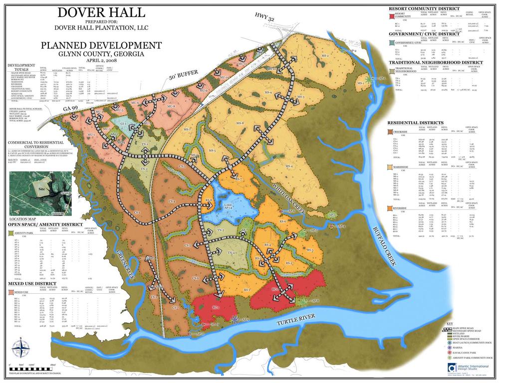
2 COMPREHENSIVE PLAN LAND USE DESIGNATION: Agricultural/Forestry and Undeveloped/Unused. EXISTING LAND USE: Vacant PROPOSED LAND USE: Mixed-Use Residential, Commercial and Public. As to the proposed use of the land, the applicant states that: The Dover Hall PD will be a mixed use residential community that will offer various residential housing opportunities, civic uses, shopping avenues, recreational activities, and other amenities. The project will develop over a period of twenty (20) to thirty (30) years. It is anticipated (that) the first resident could occupy a home in early The intent of the Dover Hall PD is to create an active residential community complete with amenities and recreational opportunities. The Master Plan envisions five neighborhoods located throughout the property. The neighborhoods will be established based on natural features of the site which create logical neighborhood edges. All neighborhoods will be linked by a system of main roads and pedestrian trail systems. The residential neighborhoods within Dover Hall will offer residents a choice of lot sizes and home types. The Mixed use designation is for the development of an active commercial and retail area to serve Dover Hall and the surrounding area. Elements of the Mixed Use Area may include a government center, shopping centers, church sites, a school site, a 10-acre park, a variety of housing types and back-of-thehouse (office warehouse) uses. The Mixed Use Area is planned to be open to the public. Amenity and Recreation areas are generally located on the conceptual Master Plan and will offer residents central locations to congregate and share in the recreational activities. Activities at the recreation areas may include pavilions, tennis courts, (an) aquatic center, playgrounds, community centers, or site(s) that all residents can use to access the tidal waters of the Turtle River, Buffalo Creek, White Oak Creek and Green Creek. SITE DESCRIPTION: The site is adjacent to, and south of GA Hwy 99. The site is generally between Buffalo Creek and Green Creek and north of the Turtle River. The property will be accessed from GA Hwy. 99. The total property is approximately 5, acres consisting of 3, acres of uplands, acres of freshwater wetlands, and 1, acres of salt marsh. Maps were submitted depicting the land and its marsh, wetland and flood prone areas (see GA DNR marsh/upland boundary survey (Exhibit A), USACOE survey depicting freshwater wetlands, and Exhibit A depicts the property s flood zones X, AE and VE according to FIRM No x Panel No. 0100C, 0200C and 205C dated September 6, Together the wetlands and marsh comprise approximately 39% of the total property ( acres wetlands acres saltwater marsh = acres/ 5, acres=.3902). The site has over 13,864 linear feet of frontage on GA Highway 99. PLANNING: Community Development has received the letter of recommendation for the Development of Regional Impact (DRI) from the Coastal Georgia Regional Development Center dated April 24, 2008 (see attached), staff awaits the recommendation of the Water and Sanitary Sewer Master Plan from ATM, consultants for the Brunswick Glynn Joint Water and Sewer Commission. In summary, the Master Plan for this development is proposing a maximum of 9,051 dwelling units proposed within three (3) residential districts: Creekside ( acres), Marshside ( acres) and Riverside ( acres) with an average density of
3 approximately +/- 3 du/ac, in addition to proposing a Traditional Neighborhood District ( acres) that will feature a higher density of approximately +/- 4 du/ac. In support of the proposed residential development, 1.16 million s.f. of commercial development is proposed to serve the area and acres will be conveyed for Government/Civic Use. Likewise, the Resort Community District ( acres) with a proposed density of approximately +/- 6.8 du/ac, Mixed Use District ( acres) and the Open Space/ Amenity District ( acres) will provide additional services and amenities to serve the district. According to the CGRDC report (see attached) in response to the demands on public infrastructure including roads, water and wastewater, the report provides the following: GDOT has determined that the project s impacts on the surrounding infrastructure will be significant and will need to be addressed in the local Metropolitan Planning Organization s Long Range Transportation Plan update due in Please be advised that subject to the Georgia Department of Community Affairs Rules for Developments of Regional Impact, Glynn County and the water supply/ wastewater treatment provider for this project may be required to submit future DRI applications pertaining to the additional water supply intake facilities and wastewater treatment facilities that will serve this project. Furthermore, staff is requesting the applicant to determine the needs for public educational facilities. As for the justification for the request to rezone the property, the applicant has responded to the following: The project would be in harmony with the Character of the Neighborhood because: The property is located west of Interstate 95 in a Growth Corridor of Glynn County and will compliment future and existing residential neighborhoods. The project would not be detrimental to the property or persons in the area because: The community will add value to adjacent properties, and provide planned/controlled growth. ENGINEERING: Previous review comments were responded to, in detail, by the applicant, and there are no further engineering comments. TRANSPORTATION: The definition for Average Daily Traffic (ADT) contained within the Glynn County Subdivision Regulations Section 501 describes the number of trips generated during a twenty-four hour period based on the total number of residential units have access to the street, and states that Ten (10) trips per day per residential unit shall be used for design purposes in this Ordinance. The Preliminary Traffic Projections report (Exhibit H) demonstrates a prorated amount due to the projected amount of internal circulation. As a result, staff accepts the calculations as submitted with the requirement that all impacted roads shall maintain a Service Level of C. UTILITIES: Water system Dover Hall shall be responsible for the design and phased construction of a water system that will provide 1000 gpm at 20 psi residual pressure at the most remote fire hydrant in any phase of development. As a part of preliminary plat approval, the applicant shall demonstrate the compliance with this performance standard. The method to demonstrate modeling compliance shall be mutually agreed upon by the applicant and BGJWSC. No preliminary plat or site plan shall be approved without demonstrating compliance with this requirement.
4 Sewer system Dover Hall is proposing to connect into a system that was not planned to carry flows from this part of the County. The specific transmission line was constructed using a mixture of public and private funds to which also allocated capacity within that line to carry waste flows from specific projects. Dover Hall was not included in these calculations. Therefore, there is not enough planned capacity in the public system at full build-out of the committed projects. In the interim there may be some capacity based upon projected building schedules. The BGJWSC master plan consultant is looking at the location and construction need for a new North Glynn treatment plant. Until the time the report is complete the ultimate waste load allocation from this development cannot be addressed. The applicant should look at an interim use of onsite treatment and disposal using spray quality effluent standards until the study is completed and then implement all required improvements to pump and transmit the wastewater to the designated connection point in the public system. SCHOOLS: It is anticipated that this development will generate approximately 4,888 school age children (9,051 DU X.54 students/du 4,888). Schools currently serving this site include: School Name Current Capacity (including portables) Current Enrollment (October, 2007 data) Glyndale Elementary School Jane Macon Middle School Brunswick High School 1,775 1,694 FIRE / POLICE: Fire review approved as submitted. FINDINGS: A workshop was held with Thomas and Hutton, agents and staff on March 25, At that time, the agents for the project provided an overview of the master plan and planned development text and discussed possibilities for water and sanitary sewer provision. This workshop was followed by a meeting held on April 21, 2008 between staff, BGJWSC and agents for the project to explore, in detail, water and sanitary sewer opportunities that exist and potential solutions for the development at full build-out. For example, Thomas and Hutton discussed the possibility of utilizing the Academy Creek Plant in lieu of on-site treatment due to the soils onsite. As a result of this meeting, staff and BGJWSC is seeking the recommendation of their consultants at ATM. In conformance with Section 1103 of the Glynn County Zoning Ordinance, the following findings of fact are to be considered in making a decision on a request for rezoning: Whether the zoning proposal will permit a use that is suitable in view of the use and development of adjacent and nearby property. The proposed project is surrounded by the Turtle Creek CID and the future Hopewell Creek project. As a result, the proposal to combine residential development with commercial development to serve the area will result in a development that is suitable in view of the use and development of adjacent and nearby properties. Whether the zoning proposal will adversely affect the existing use or usability of adjacent or nearby property. The request to rezone this property to a Planned Development will allow for greater usability and compatibility of design within the site and throughout the surrounding areas.
5 Whether the property to be affected by the zoning proposal has a reasonable economic use as currently zoned. No. Currently, the property is zoned as FA (Forest Agricultural) and would not allow for this level of intensity, featuring a mixture of residential and commercial development. Whether the zoning proposal will result in a use, which will or could cause an excessive or burdensome use of existing streets, transportation facilities, utilities, or schools. Yes, the project will produce a substantial increase in the average daily vehicle trips, and will increase the impacts upon utilities and schools. As a result, the applicant is proposing to make contributions towards the water and sewer infrastructure and roadways, and is proposing to contribute over acres to the County for public services. Whether the zoning proposal is in conformity with the policy and intent of the Comprehensive Land Use Plan. The Future Land Use Map shows the area as Agriculture/Forestry and Undeveloped/Unused. Whether there are other existing or changing conditions affecting the use and development of the property, which give supporting grounds for approval or disapproval. The proposal consists of a mixture of housing types, commercial development and additional community services allowing this Development of Regional Impact to advance the level of services and amenities in West Glynn County. CONCLUSIONS: In summary, the Coastal Georgia Regional Development Center found the project to be compliant with the Development of Regional Impact (DRI) requirements with conditions. At this time, staff awaits the recommendation of ATM, consultants for the BGJWSC, regarding the provision of water and sanitary sewer for this development of regional impact. ALTERNATIVES: 1. Approve the request as submitted. 2. Deny the request as submitted. 3. Defer the request at the request of the applicant or at the request of staff. RECOMMENDATION: Staff recommends approval of the rezoning request and acceptance of the Master Plan for ZM1199 Dover Hall from FA (Forest Agricultural) to PD (Planned Development), subject to the following conditions: 1. The developer and staff shall work together with the Glynn County School Board. 2. Traffic: The applicant shall maintain the level of service in place at the time a site plan or subdivision is submitted for all proposed roads within the development and intersections of proposed streets or driveways with SR99. The lowest Level of Service within the development shall be C. Due to the size of the development, it is anticipated that it will have a significant impact on SR 99, adjacent to the development and for some distance to the intersection with state
6 routes, which provide an east/west connection. The County shall take traffic counts on at least an annual basis when the development begins to establish a proportional division of the increased traffic on these routes from the development. When a roadway improvement project is defined, the applicant shall be responsible for their proportional share of the required improvements, including any additional built capacity that accrues, benefiting the applicant. Should the County adopt impact fees for transportation improvements, the applicant may request credit for expenditures made to SR 99 associated with adding capacity but not associated with required improvements for entrances or intersections. The amount of the credit shall not exceed the cost to construct the improvements so long as the cost is of equal or greater value than that which would have been collected through the payment(s) of the road component of the impact fees as determined by the County Engineer. Once the sum total amount of the credit exceeds the cost of the improvements, as determined by the County Engineer, the applicant shall thereafter commence paying the impact fee as set forth in any adopted Impact Fee Ordinance. For the purposes of this condition, the costs, as approved by the County Engineer, shall include, but not be limited to, the cost of right-of-way acquisition, engineering costs, costs of relocating utilities and actual costs of construction (including labor, materials, and overhead) ( Work ). Before any Work is performed, the applicant shall receive prior written approval by the County Engineer and County Administrator for the improvements and any credit amount. 3. A recommendation is required for the Water and Sanitary Sewer Master Plan from ATM, consultants of The Brunswick Glynn County Water and Sewer Commission while addressing the following criteria with regards to water and sewer provision: Water system Dover Hall shall be responsible for the design and phased construction of a water system that will provide 1000 gpm at 20 psi residual pressure at the most remote fire hydrant in any phase of development. As a part of preliminary plat approval, the applicant shall demonstrate the compliance with this performance standard. The method to demonstrate modeling compliance shall be mutually agreed upon by the applicant and BGJWSC. No preliminary plat or site plan shall be approved without demonstrating compliance with this requirement. Sewer system Dover Hall is proposing to connect into a system that was not planned to carry flows from this part of the County. The specific transmission line was constructed using a mixture of public and private funds to which also allocated capacity within that line to carry waste flows from specific projects. Dover Hall was not included in these calculations. Therefore, there is not enough planned capacity in the public system at full build-out of the committed projects. In the interim there may be some capacity based upon projected building schedules. The BGJWSC master plan consultant is looking at the location and construction need for a new North Glynn treatment plant. Until the time the report is complete, the ultimate waste load allocation from this development cannot be addressed. The applicant should look at an interim use of onsite treatment and disposal using spray quality effluent standards until the study is completed and then implement all required improvements to pump and transmit the wastewater to the designated connection point in the public system. GLYNN COUNTY MAINLAND PLANNING COMMISSION ACTION: At its meeting of July 1, 2008 the Mainland Planning Commission recommended approval of the rezoning, along with the Planned Development Master Plan and Text with the staff recommended conditions, as follows: Motion: Second: Bill Brunson William Buck Crosby
7 Aye: Bill Brunson, Jason Counts, Eric Croft, William Buck Crosby, Leman L. Buddy Hutchinson, Gary Nevill Nay: Abstaining: Absent: None None Wayne Stewart ADDENDUM TO MAINLAND PLANNING COMMISSION ACTION: At a workshop meeting on August 12 the Mainland Planning Commission discussed conditions recommended for larger projects, such as this one. The consensus was to have Chairman Gary Nevill forward a letter to the Board of Commissioners reflecting the discussion. The letter is attached to this report (Attachment A1) and contains suggestions for modifying the conditions as originally recommended. RECOMMENDED MOTION: The following motion shows modifications suggested in the attached letter from the Chairman: I move to approve the rezoning request and accept the Master Plan for ZM1199 Dover Hall from FA (Forest Agricultural) to PD (Planned Development), subject to the following conditions: 1. The developer and staff shall work together with the Glynn County School Board. 2. Traffic: The applicant shall maintain the level of service in place at the time a site plan or subdivision is submitted for all proposed roads within the development and intersections of proposed streets or driveways with SR99. The lowest Level of Service within the development shall be C. Due to the size of the development, it is anticipated that it will have a significant impact on SR 99, adjacent to the development and for some distance to the intersection with state routes, which provide an east/west connection. The County shall take traffic counts on at least an annual basis when the development begins to establish a proportional division of the increased traffic on these routes from the development. When a roadway improvement project is defined, the applicant shall be responsible for their proportional share of the required improvements, including any additional built capacity that accrues, benefiting the applicant. Should the County adopt impact fees for transportation improvements, the applicant may request credit for expenditures made to SR 99 associated with adding capacity but not associated with required improvements for entrances or intersections. The amount of the credit shall not exceed the cost to construct the improvements so long as the cost is of equal or greater value than that which would have been collected through the payment(s) of the road component of the impact fees as determined by the County Engineer. Once the sum total amount of the credit exceeds the cost of the improvements, as determined by the County Engineer, the applicant shall thereafter commence paying the impact fee as set forth in any adopted Impact Fee Ordinance. For the purposes of this condition, the costs, as approved by the County Engineer, shall include, but not be limited to, the cost of right-of-way acquisition, engineering costs, costs of relocating utilities and actual costs of construction (including labor, materials, and overhead) ( Work ). Before any Work is performed, the applicant shall receive prior written approval by the County Engineer and County Administrator for the improvements and any credit amount.
8 3. A recommendation is required for the Water and Sanitary Sewer Master Plan from ATM, consultants of The Brunswick Glynn County Water and Sewer Commission while addressing the following criteria with regards to water and sewer provision: Water system Dover Hall shall be responsible for the design and phased construction of a water system that will provide 1000 gpm at 20 psi residual pressure at the most remote fire hydrant in any phase of development. As a part of preliminary plat approval, the applicant shall demonstrate the compliance with this performance standard. The method to demonstrate modeling compliance shall be mutually agreed upon by the applicant and BGJWSC. No preliminary plat or site plan shall be approved without demonstrating compliance with this requirement. Sewer system Dover Hall is proposing to connect into a system that was not planned to carry flows from this part of the County. The specific transmission line was constructed using a mixture of public and private funds to which also allocated capacity within that line to carry waste flows from specific projects. Dover Hall was not included in these calculations. Therefore, there is not enough planned capacity in the public system at full build-out of the committed projects. In the interim there may be some capacity based upon projected building schedules. The BGJWSC master plan consultant is looking at the location and construction need for a new North Glynn treatment plant. Until the time the report is complete, the ultimate waste load allocation from this development cannot be addressed. The applicant should look at an interim use of onsite treatment and disposal using spray quality effluent standards until the study is completed and then implement all required improvements to pump and transmit the wastewater to the designated connection point in the public system. ATTACHMENTS: APPENDIX A1 AUGUST 12 LETTER FROM CHAIRMAN GARY NEVILL APPENDIX A2 LOCATION MAP APPENDIX B ZONING MASTER PLAN APPENDIX C PLANNED DEVELOPMENT TEXT APPENDIX D COASTAL GEORGIA REGIONAL DEVELOPMENT CENTER RESPONSE LETTER APPENDIX E STAFF COMMENTS APPENDIX F APPLICANT RESPONSE LETTERS
9 Aug :22p p.2 August 12,2008 Glynn County Board of Commissioners 701 G Street Brunswic~ GA Dear Commissioners; The Glynn County Mainland Planning Commission met today with David Hainley, York Phillips and some ofthe owners, developers and representatives connected with the Dover Hall (ZM 1199) rezoning and the Northwest Quadrant (ZM 1270) rezoning. Both ofthese projects have been approved by the MPC. The discussion centered on the conditions attached to the recommendation for approval ofthe rezoning which were principally the same for both projects. The Dover Hall rezoning was approved by the Mainland Planning Commission with the conditions attached while the Northwest Quadrant was approved with deletions and modifications to the conditions, The meeting raised questions and concerns about the implementation and legality of condition No.2, Traffic. While not formerly approved by a vote, it was the consensus and recommendation of the MPC that you approve the Dover Hall rezoning as we did but with the same deletions and revisions we applied to the Northwest Quadrant approval. They were as follows: Condition No.1 (School Board): Approve as submitted. Condition No.2 (Traffic): Delete condition in entirety. Condition No.3 (Water and Sewer): Strike all but a portion ofthe first sentence to read as follows. "A recommendation is required for the Water and Sanitary Sewer Master Plan From ATM, consultants of the Brunswick - Glynn Joint Water and Sewer Commission." I would like to commend David Hainley and his staff for looking out for Glynn County and its transportation funding needs. If you have any questions please do not hesitate to call. ~~DCerelY' JL;<[} Gary C. Nevill an, MPC
10 W FA 144 FA FA FA 127 FA FA FA CP 109 FA BLADEN 145 FA HIGHWAY 99 JAMAICA ZM1199 (ZM (M)) Dover Hall FA FA PDG FA FA PDG PDG PDG 110 OAK GROVE ISLAND PDG RE PDG CP PDG PDG SHIPMASTER PDG PDG PDG PDG 146 BOGIE CP PDG FA FA CP PDG CP ,450 2,900 5,800 Feet³
11
12 DOVER HALL Glynn County, Georgia PLANNED DEVELOPMENT REZONING APPLICATION April 2, 2008 Revised May 22, 2008 Revised June 11, 2008 Prepared for: Dover Hall Plantation, LLC 1299 Thompson Drive Douglas, GA Prepared by: Atlantic International Design Studio 5 Dunmore Court, Suite 2 Hilton Head, SC (843) Thomas & Hutton Engineering Co. P.O. Box 2727 Savannah, GA (912) Submitted to: The Glynn County Planning Commission and The Glynn County Board of Commissioners
13 TABLE OF CONTENTS i. Formal Application for a PD Written Zoning Text Requirements (Sec (c)) Section 1 Introduction and Description of Proposal Page A. The Property 1 B. Property Ownership and Legal Description 1 C. Intent of Dover Hall PD 1 D. Planned Development Process 2 E. Zoning Master Plan and Development Schedule 2 F. Storm Water Management 3 G. Wetlands and Salt Marsh 3 H. Water and Sewer Services 3 I. Site Access and Traffic 6 J. Environmental and Cultural Resource Studies 6 K. Dedications to Glynn County 6 L. Restrictive Covenants 7 M. Development Standards 7 Section 2 Dover Hall Land Use Designation, Development Standards, and Definitions A. Introduction 8 B. Allowed Density and Transfer of Density Between Planning Districts 8 C. Allowed Land Uses and Development Standards 9 D. Dover Hall Development Standards Table 14 E. Exceptions to Glynn County Zoning and Subdivision Ordinances 15 F. Definitions of Land Use Terms and Density Terms 15 Exhibits Exhibit A Plat of Dover Hall Plantation Exhibit B Corps of Engineers Wetland Jurisdictional Determination Approval/Georgia Department of Natural Resource Salt Marsh Letter Exhibit C The Dover Hall Conceptual Master Plan Exhibit D The Dover Hall 2006 Aerial Photograph Exhibit E The Dover Hall Topographic Map Exhibit F The Dover Hall Digital Elevation Model Exhibit G The Dover Hall Water and Sewer Demands Exhibit H The Dover Hall Traffic Report Exhibit I Phase I Environmental Site Assessment Exhibit J Cultural Resource Overview Exhibit K Threatened and Endangered Species Report Appendices Appendix A - Glynn County Zoning Ordinance Appendix B - Glynn County Subdivision Regulations
14 Formal Application for a PD Written Zoning Text Requirements Sec (c): A written Zoning Text shall also be submitted for review and approval and shall include: a) A general description of the proposal; Refer to Section 1 A. and C. b) A statement of the present ownership and a legal description of the property; Refer to Section 1 B. c) Proposed land uses and development standards, density and height limitations, yard requirements all of which shall be compatible with other nearby uses within and without the proposed district and in keeping with the intent of the Glynn County Comprehensive Plan. Refer to Section 2 C. and D. d) A listing of permitted uses for each separate tract within a particular PD. The uses permitted in the district shall be restricted to those listed, approved, and adopted by the Board of Commissioners. Refer to Section 2 C. e) Exceptions or variations from the requirements of the Zoning Ordinance, if any are being requested; Refer to Section 2 E. f) Tables showing the total number of acres in the proposed development and the percentage designated for each proposed type of land use, including public facilities; Refer to Section 2 B. and the Concept Plan. g) Tabulations showing the maximum number, type and density of dwelling units proposed for each building site; Refer to Section 2 B. and the Concept Plan. h) Proposed dedication or reservation of land for public use, including streets, easements, parks and school sites; Refer to Section 1 J. i) Proposed uses or development standards for open space, courts, walks and common areas; Refer to the Concept Plan and Section 2 F. 2. and 11. j) Information pertaining to the provision for utilities, including water, sewer and drainage facilities including projected demands; Refer to Section 1 F. and H. k) Plans for parking, loading, access ways, signs, buffers and means of protecting adjacent areas from lighting and other potential adverse effects; Refer to Section 1 and Section 2. l) A development schedule indicating the approximate date when construction of each site or phase of development can be expected to begin and be completed; and Refer to Section 1 E. m) A statement regarding landscaping and tree preservation. Refer to Section 2 F. 2., 11., and 15. i.
15 SECTION 1 INTRODUCTION AND DESCRIPTION OF PROPOSAL A. The Property The Dover Hall Planned Development is located in south-western Glynn County. The property is currently zoned agriculture. The site is adjacent to GA Highway 99 which links to Interstate 95 at I-95 Exit 42. The site is bounded to the north by GA Highway 99 and to the east by Buffalo Creek and on the west by Green Creek and to the south by the Turtle River. Boundary Surveys of the property prepared by Thomas & Hutton Engineering Company are included as Exhibit A. The total property is approximately +/-5,245 acres consisting of +/-3,198 acres of uplands, +/-292 acres of freshwater wetlands, and +/-1,754 acres of salt marsh. The Georgia DNR marsh/upland boundary delineating the salt marsh has been surveyed and is shown on the Boundary Survey (Exhibit A). The freshwater wetlands have been surveyed and approved by the United States Army Corps of Engineers Jurisdictional wetlands approval. Exhibit A also includes the flood zones for the property which includes Zone X, Zone AE and Zone VE according to FIRM No Panel No. 0100C, 0200C and 205C dated September 6, B. Property Ownership and Legal Description The Dover Hall property is comprised of two Tracts. The largest tract (+/- 5,345 acres) is owned by Dover Hall Plantation, LLC and a smaller tract (+/- 100 acres) is owned by Dover Hall Tract 100, LLC. Exhibit B contains the property deeds and legal descriptions. The property is currently being used for silviculture. Exhibit D is a 2006 photo of the property and illustrates the amount of pine plantation that occupies the property. Exhibit E and Exhibit F are topographic maps of the property. The topography is based on aerial digital information collected and processed to obtain one (1) foot contour intervals. The information has an accuracy of +/- six inches over ninety percent of the property and is adequate for use in planning the property. Elevations on the property range from elevation 6 to 15 NGVD (1929 datum). C. Intent of the Dover Hall PD The intent of the Dover Hall PD is to create an active residential community complete with amenities and recreational opportunities. The Master Plan envisions five neighborhoods located throughout the property. The neighborhoods will be established based on natural features of the site which create logical neighborhood edges. All neighborhoods will be linked by a system of main roads and pedestrian trail systems. The residential neighborhoods within Dover Hall will offer residents a choice of lot sizes and home types. The Mixed Use designation is for the development of an active commercial and retail area to serve Dover Hall and the surrounding area. Elements of the Mixed Use Area may include a government center, shopping centers, church sites, a school site, a 10 acre park, a variety of housing types and back-of-the-house (office warehouse) uses. The Mixed Use Area is planned to be open to the public. Amenity and Recreation areas are generally located on the Conceptual Master Plan and will offer residents central locations to congregate and share in the recreational activities. Activities at the recreation areas may include pavilions, tennis courts, aquatic center, playgrounds, community centers, or site(s) that all residents can use to access the tidal waters of the Turtle River, Buffalo Creek, White Oak Creek and Green Creek. The impact on the Glynn County school system is difficult to determine. The targeted market for Dover Hall will be retirees and empty nesters. Certainly, active families with children will also be a component of the neighborhood. Approximately 25 acres has been reserved for a school site. The general location of the school site is depicted on the Conceptual Master Plan. Dover Hall Plantation, LLC or its successor shall work with the 1
16 school district to determine school needs and a preferred location of a site within the property if it is determined a school is needed. The property is located in the following school districts: Glyndale Elementary School Jane Macon Middle School Brunswick High School. D. Planned Development Process The Planned Development Process is based on the Glynn County Zoning Ordinance. The following process will be established for submittal and approval of the Dover Hall PD. 1. The review and approval of the Planned Development Zoning Master Plan (rezoning) is by the Glynn County Planning Commission, and subsequently Glynn County Commission. The Conceptual Master Plan establishes the framework for development of Dover Hall over an extended time frame. Land uses, density, environmental quality, utility service are described in this document. 2. Development Plans consist of: Preliminary and Final Plats for single family residential, and Site Plans for traditional neighborhood, amenity recreation areas, and/or neighborhood commercial tracts. 3. The Development Plans will be submitted for approval to the County for each portion/phase of the tract to be developed. The Development Plans will describe specific development in detail as studies and designs are prepared. Specific development standards for individual lot setbacks, buffers, minimum lot area, lot coverage, road design standards, building heights and other development standards shall be in accordance with those established in this document or as amended by the Owner and accepted by Glynn County. Specific subdivisions (final plats), Multi-family, Amenity Recreation areas, and commercial site plans will be submitted to the County for development approval. Supporting documentation of the appropriate detail is required at each level of approval. E. Zoning Master Plan and Development Schedule The Dover Hall Planned Development is anticipated to be constructed in multiple phases (neighborhoods) over a period of approximately 20 to 30 years. Development will occur in accordance with the Conceptual Master Plan (Exhibit C) as set forth in this document or amended in the future. The Conceptual Master Plan outlines the general scope of the development including number of units, development standards, open space and other issues. The Conceptual Master plan is non-specific in regard to the final location of land uses and location of residential development to allow flexibility in the future. Actual development may yield significantly less density. Based on changing market conditions over the time of development of Dover Hall, reduction of density shall be allowed. Additionally, allowing a particular land use or amenity does not obligate Dover Hall, LLC or its successors to provide them. The goal of the development is to produce a high quality, environmentally sensitive community. The large tract of land provides an opportunity for a mix of land uses that may be developed over a long period of time. The PD designation is necessary to accommodate the mix of land uses and provide for the responsible planning and development of the property over a long time frame. The Dover Hall property is currently used for timber production. A commitment to forestry will be maintained as part of the Master Plan, with silviculture exemptions for applicable regulations and taxes remaining in place until such time as a particular tract of land is platted for subdivision. The Conceptual Master Plan (refer to Exhibit C) for the Dover Hall project shows a maximum development density of 3.0 du/upland acres or 9,051 dwelling units, 1,160,000 square feet of commercial, and 260,000 square feet of institution, government, and civic uses. Additionally the concept plan shall allow for the conversion of commercial acreage to residential. A cap of 400 DU s shall be placed on the residential to commercial conversion. Refer to Section 2 B. for conversion specifics. Proposed land uses in the development are detailed under Section 2 Land Use Designation, Development Standards, and Definitions. The land uses 2
17 anticipate development of residential communities with amenities, recreational facilities, and a commercial use area. The Conceptual Master Plan seeks to maintain significant areas of open space including neighborhood parks and open space corridors. The open space and amenities will be owned and maintained by the developer, homeowner s association, or other legally designated entity. Property deeded to a governmental entity becomes the maintenance responsibility of that entity. The Conceptual Master Plan constitutes an amendment to the current Glynn County Ordinances. The Master Plan introduces land uses that do not exist or have different requirements than those found in the current zoning documents. Land uses such as: Community Recreation and Community River Access are part of the Conceptual Master Plan. The provisions of the Conceptual Master Plan, Exhibits, and Appendices shall apply to development of the Dover Hall Planned Development. In the event of a conflict, the hierarchy of documents is this document and then the Zoning Ordinance of Glynn County or the Subdivision Regulations contained in this document as Appendices A and B. Future ordinance changes by Glynn County will not apply to this PD zoning. F. Storm Water Management The developer or his successors will prepare a storm water management plan for each phase of the Dover Hall project. The plan will address site hydrological characteristics, predevelopment conditions, post development runoff, and storm water management facilities for flood control and treatment. The storm water management plan will consider future construction, and it will detail the ability of the lagoon system to treat runoff and control release rates during storm events as required. As part of the development process, the Owners or its assignees will implement Best Management Practices (BMPs) for Storm Water Management. The BMPs dictate storm water management standards. Use of detention lagoons, where possible, is a practice of treating storm water prior to release to the receiving stream in order to meet water quality standards defined by local and state regulations. G. Wetlands Freshwater wetlands on the property are typical of coastal Georgia. Approximately 5 percent of the land area above mean high water consists of jurisdictional and isolated/non jurisdictional freshwater wetlands. The salt marsh and freshwater wetlands are shown on Exhibits A and B. The freshwater wetlands have been flagged, surveyed and verified by the Corps of Engineers (COE). H. Water and Sewer Services 1. General: The project site consists of an approximately 5,245-acre parcel located in southwestern Glynn County and is shown as Parcel ID Numbers and The site is adjacent to GA Highways 99 and 32, which link directly to Interstate 95 at exit 42. The approximate longitude and latitude for the site are 31º N, 81º W. The site presently is wooded and used for silviculture. The central portion of the site is transected by a right-of-way for the Colonel s Island Railroad. To the north of the site are GA Highways 99 and 32, and low density residential and agricultural/timber land. To the east are the marshes and waterway of Buffalo Creek, to the south are the marshes and waterway of the Turtle River, and to the west are the marshes and waterway of Green Creek. The Master Plan for the project consists of 2, upland development acres, divided into eight districts as follows: 3
18 TABLE 1: DOVER HALL DEVELOPMENT DISTRICTS Development District Upland Acres Open Space/Amenity District Mixed Use District Resort Community District Government/Civic District Traditional Neighborhood District Creekside Residential District Marshside Residential District Riverside Residential District TOTAL 2, Development type and density, and hence water demands and wastewater generation, will vary within each development district. The overall maximum development for the project will be 9,451 dwelling units, 640,000 square feet of commercial development, and 260,000 square feet of Institutional/Civic development. The estimated build-out timeframe for the project is twenty years to forty years. 2. Wastewater Generation Projections: Wastewater generation projections were estimated by using the unit loading rates presented in Table 2 as follows: TABLE 2: WASTEWATER UNIT LOADING RATES Development Type Residential* Commercial Institutional/Civic Ancillary, Municipal, Recreation** Unit Loading 350 GPD/Unit 200 GPD/1,000 SF 20 GPD/1,000 SF 25 GPD/Acre * For master planning purposes flow projections are based on Georgia EPD required 350 gpd per single residential lot. ** Total of acres of Open Space Corridor planned. Wastewater generation based on the unit loadings provided in Table 2 has been calculated for the development. Table 3 presents the anticipated build-out wastewater flows as follows: TABLE 3: BUILD-OUT WASTEWATER GENERATION PROJECTIONS Development Type Ave. Day Wastewater Generation (GPD) Peak Wastewater * Generation (GPD) Residential 3,307,850 8,269,625 Commercial 128, ,000 Institutional/Civic 5,200 13,000 Ancillary, Municipal, Recreation 4,635 11,588 TOTAL 3,445,685 8,614,213 *Peaking factor equals
19 3. Water Demand Projections: Water demands for the project were calculated based on projected land use and development as discussed previously. Unit loadings for water demands are as follows: TABLE 4: WATER UNIT LOADING RATES Development Type Residential * Commercial Institutional/Civic Ancillary, Municipal, Recreation** Unit Loading 400 GPD/Unit GPD/1,000 SF 26.7 GPD/1,000 SF 33.3 GPD/Acre * For master planning purposes flow projections are based on the Georgia EPD required 400gpd per single residential lot. ** Total of acres of Open Space Corridor planned. Water demand based on unit loading provided in Table 4 has been calculated for the development. Table 5 presents the anticipated build-out water demand as follows: TABLE 5: BUILD-OUT WATER DEMAND PROJECTIONS Development Type Average Day Water Demand (GPD) Peak Day Water * Demand (GPD) Peak Hour Water ** Demand (GPD) Residential 3,780,400 6,804,720 10,207,080 Commercial 170, , ,858 Institutional/Civic 6,942 12,496 18,743 Ancillary, Municipal, Recreation 6,174 11,113 16,670 TOTAL 3,964,204 7,135,567 10,703,351 * Peak Day factor equals 1.8. ** Peak Hour factor equals 2.7. Actual build-out demands may vary based on actual development and individual usage. 4. Water Supply and Wastewater Treatment/Disposal: It is proposed that the Dover Hall development be served by the newly formed Brunswick-Glynn Joint Water & Sewer Commission (BGJWSC) combined City/County water and sewer systems. The Developer desires to enter into a water and sewer agreement with the BGJWSC that specifies the Commission s commitment to serve the project and the associated cost responsibility of the Developer. The Developer wishes to work with the BGJWSC to determine the best method for wastewater treatment and disposal for the project and to develop a cost sharing program for the water and sanitary sewer systems. Existing BGJWSC water infrastructure does not extend to the immediate vicinity of the Dover Hall development. Infrastructure needed to meet water demands from the development under build-out conditions likely would include three water supply wells, each with a capacity of 2,000 GPM to 3,000 GPM at a connection pressure of approximately 80 PSI, an elevated water storage tank of a minimum 500,000-gallon capacity, and a network of water transmission and distribution mains throughout the development. The conceptual layout of the water supply system improvements at development build-out is shown on the Water Distribution System Master Plan (refer to Exhibit H). Actual water system requirements for the development will be determined from final design. Over time, it is expected that the 5
20 water system improvements constructed for the development would be connected to the BGJWSC water infrastructure through extensions along Highway Route 82 to the South and Highway Routes 99 and 341 to the north and east. Within the development, wastewater collection will be accomplished with a combination of gravity sewers, multiple regional sewer pump stations, and a master sewer pump station. The conceptual layout of the sanitary sewer collection system at development build-out is shown on the Sanitary Sewer System Master Plan (refer to Exhibit H). Actual sanitary sewer system requirements will be determined from final design. The master sewer pump station will pump wastewater from the development, and possibly from other offsite developments, to BGJWSC collection, treatment, and disposal facilities. Wastewater generated from interim development (first roughly 1,000 ERU) will be conveyed to the BGJWSC collection system, and ultimately to the Academy Creek Water Pollution Control facility for treatment and disposal. Preliminary calculations indicate that connection to the BGJWSC collection system will be accomplished through the installation of a 10-inch diameter force main along Highway Routes 99 and 341 with a manifold connection to an existing 10-inch diameter force main located along Highway Route 341. Beyond the initial +/-1,000 ERU, it is anticipated that sewer flows would reach the maximum capacities of the existing collection and conveyance system to the Academy Creek Water Pollution Control facility. Potential options to accommodate increased future wastewater flows from the development include the installation of a dedicated parallel force main along Highway 341 to the Academy Creek Water Pollution Control facility in conjunction with upgrades to existing pump stations, or installation of a force main to the planned North Mainland Water Pollution Control facility. I. Site Access and Traffic Access to Dover Hall will be from GA Highway 99. Three main entrances off GA Highway 99 are proposed. The main entries may be supplemented by limited access entries at six other locations along GA Highway 99. A copy of Exhibit H Preliminary Traffic Projections, J-18548, March 2008, includes traffic count projections for the project at build-out. J. Environmental and Cultural Resource Studies 1. Phase I Environmental Site Assessment Newbank s Environmental Team performed a Phase I Environmental Site Assessment. The assessment revealed no evidence of Recognized Environmental Conditions in connection with the Dover Hall PD site. Refer to Exhibit I for the complete study. 2. Cultural Resource Overview Brockington and Associates, Inc. conducted a preliminary cultural resource study for the Dover Hall PD site in April of The report identified locations where potential site of significance may be. Prior to the development within a master planned area of the site cultural resource issues shall be addressed with the appropriate government agencies and mitigation/preservation issues will be resolved as required by law. A copy of the Brockington report is included as Exhibit J. 3. Threatened and Endangered Species Report Sligh Environmental Consultants (SEC) was retained to conduct a survey of endangered plants and animals on the site. SEC concluded that the site affords little suitable habitat to support threatened or endangered species due to the historic timber management activities and lack of prescribed burning. No evidence of any listed endangered species was found. A copy of the full report is included as Exhibit K. 6
21 K. Dedications to Glynn County 1. Dedication of Roads and Storm Drainage Systems The Owner will construct all roads and storm drainage in accordance with Glynn County Standards. All roads that are accessible by the public will be dedicated to Glynn County. The Developer will establish a Home Owners Association (HOA) or other approved entity to own and maintain the roads and drainage system within any gated community. 2. Coordination of Water and Waste Water Systems The proposed water and waste water system will be designed and constructed to the standards of the Brunswick Glynn County Joint Water and Sewer Commission (BGCJWSC) specifications. The Developer will dedicate the completed and accepted systems to the BGCJWSC for ownership, maintenance, and operation. 3. Approximately 31 acres of land parallel to GA Highway 99 (100 depth) has been reserved for future road access considerations and a minimum 50 buffer zone. 4. Three government/civic sites are located within the Mixed Use Area and along Highway 99 consisting of approximately 35 acres of upland and 5 acres of wetland as indicated on the Conceptual Master Plan. Uses may include government offices, schools, police, fire station, well sites, water towers and EMC uses. The exact location of the government/civic sites shall be coordinated with the county and other appropriate county agencies. 5. The conveyance of the property to be dedicated to Glynn County and included as part of the government/civic district shall occur upon request from Glynn County within a mutually agreed upon time frame between the owners of Dover Hall and Glynn County. L. Restrictive Covenants The Owner will prepare Restrictive Covenants that will be applied to Dover Hall. The Restrictive Covenants will be recorded with the Glynn County Clerk of Superior Court and will be enforced by the Owner or its designee. M. Development Standards Site development within the Dover Hall PD will be controlled by the development standards that are established in Section 2 of this document and the Glynn County Water Resource Protection Ordinance. In the event of a conflict, the hierarchy of documents shall be this document and then the Glynn County Zoning Ordinance and Subdivision Regulations included as Appendices A and B. 7
TO: Glynn County Board of Commissioners. Eric Landon, Planner II. ZM2773 Peppertree Crossing Phase II
 COMMUNITY DEVELOPMENT DEPARTMENT Planning and Zoning Division 1725 Reynolds Street, Suite 200, Brunswick, GA 31520 Phone: 912-554-7428/Fax: 1-888-252-3726 TO: Glynn County Board of Commissioners MEMO FROM:
TO: Glynn County Mainland Planning Commission. Iris M Thielen Johnston, AICP, Planner III. ZM2459 Planting Hammock. DATE: September 24, 2012
 MEMO COMMUNITY DEVELOPMENT DEPARTMENT Planning and Zoning Division 1725 Reynolds Street, Suite 200, Brunswick, GA 31520 Phone: 912-554-7428/Fax: 1-888-252-3726 TO: Glynn County Mainland Planning Commission
701 G Street Brunswick, Georgia Phone: (912) Fax: (912)
 Fax: (912)") GLYNN COUNTY BOARD OF COMMISSIONERS MEMO TO: Glynn County Mainland Planning Commission 701 G Street Brunswick, Georgia 31520 Phone: (912) 554-7400 Fax: (912) 554-7596 FROM: SUBJECT: Eric Landon, Planner
GLYNN COUNTY BOARD OF COMMISSIONERS MEMO TO: Glynn County Mainland Planning Commission 701 G Street Brunswick, Georgia 31520 Phone: (912) 554-7400 Fax: (912) 554-7596 FROM: SUBJECT: Eric Landon, Planner
LAMPADOSHIA DEVELOPMENT
 COLDWELL BANKER COMMERCIAL SAUNDERS REAL ESTATE LAMPADOSHIA DEVELOPMENT WAVERLY, GA CAMDEN COUNTY 10,779 +/- ACRES SREland.com/Lampadoshia David Hitchcock ALC, CCIM 863.727.7155 Dean Saunders, ALC, CCIM
Marion County Board of County Commissioners
 Marion County Board of County Commissioners Date: 6/4/217 P&Z: 9/25/217 BCC Transmittal: 1/17/217 BCC Adopt: TBD Amendment No: 217-L6 Type of Application Large-Scale Comp Plan Amendment Request: Change
GLYNN COUNTY BOARD OF COMMISSIONERS OFFICE OF COMMUNITY DEVELOPMENT
 GLYNN COUNTY BOARD OF COMMISSIONERS OFFICE OF COMMUNITY DEVELOPMENT 1725 Reynolds Street - Suite 200 - Brunswick, Georgia 31520-6435 Phone: (912) 554-7428 MEMO TO: Glynn County Mainland Planning Commission
PLANNED UNIT DEVELOPMENTS (Ordinance No.: 3036, 12/3/07; Repealed & Replaced by Ordinance No.: 4166, 10/15/12)
") 159.62 PLANNED UNIT DEVELOPMENTS (Ordinance No.: 3036, 12/3/07; Repealed & Replaced by Ordinance No.: 4166, 10/15/12) A. PURPOSE 1. General. The Planned Unit Development (PUD) approach provides the flexibility
159.62 PLANNED UNIT DEVELOPMENTS (Ordinance No.: 3036, 12/3/07; Repealed & Replaced by Ordinance No.: 4166, 10/15/12) A. PURPOSE 1. General. The Planned Unit Development (PUD) approach provides the flexibility
PLANNING COMMISSION STAFF REPORT
 COMMUNITY DEVELOPMENT DEPARTMENT Planning and Zoning Division 1725 Reynolds Street, Suite 200, Brunswick, GA 31520 Phone: 912-554-7428/Fax: 1-888-252-3726 PLANNING COMMISSION STAFF REPORT DATE: January
CHECKLIST FOR DEVELOPMENT REVIEW
 CHECKLIST FOR DEVELOPMENT REVIEW Petitions and related documents and plans for land development or other proposals regulated by Title 16 of the Municipal Code (Development Ordinance) and Title 17 of the
SECTION 16. "PUD" PLANNED UNIT DEVELOPMENT OVERLAY DISTRICT
 SECTION 6. "PUD" PLANNED UNIT DEVELOPMENT OVERLAY DISTRICT Subsection. Purpose. This district is established to achieve the coordinated integration of land parcels and large commercial and retail establishments
Cobb County Community Development Agency Zoning Division 1150 Powder Springs St. Marietta, Georgia 30064
 Cobb County Community Development Agency Zoning Division 1150 Powder Springs St. Marietta, Georgia 30064 Case # Z-63 Public Hearing Dates: PC: 11-06-18 BOC: 11-20-18 SITE BACKGROUND Applicant: Loyd Development
Chapter 100 Planned Unit Development in Corvallis Urban Fringe
 100.100 Scope and Purpose. Chapter 100 Planned Unit Development in Corvallis Urban Fringe (1) All applications for land divisions in the Urban Residential (UR) and Flood Plain Agriculture (FPA) zones within
APPLICATION REVIEW CHECKLISTS
 APPLICATION REVIEW CHECKLISTS The following must be submitted with and are part of each application. No application is complete until all required documentation has been submitted to the Community Development
Cover Letter with Narrative Statement
 Cover Letter with Narrative Statement March 31, 2017 rev July 27, 2017 RE: Rushton Pointe Residential Planned Unit Development Application for Public Hearing for RPUD Rezone PL2015 000 0306 Mr. Eric Johnson,
HERON LANDING SUBDIVISION
 HERON LANDING SUBDIVISION Engineering Comments: Per FEMA guidelines, any development greater than 5 acres in size or subdivision 50 lots in size, requires a flood study. Width of drainage easement to be
TO: Glynn County Islands Planning Commission. Karl W. Bursa, AICP, Planner II. PP3105 Stillwater Phase III. DATE: November 10, 2015
 COMMUNITY DEVELOPMENT DEPARTMENT Planning and Zoning Division 1725 Reynolds Street, Suite 200, Brunswick, GA 31520 Phone: 912-554-7428/Fax: 1-888-252-3726 TO: Glynn County Islands Planning Commission FROM:
BY BOARD OF COUNTY COMMISSIONERS AN ACT TO BE ENTITLED
 BY BOARD OF COUNTY COMMISSIONERS ORDINANCE NO. AN ACT TO BE ENTITLED AN ORDINANCE AMENDING THE PASCO COUNTY LAND DEVELOPMENT CODE, ARTICLE 700, BY REPEALING EXISTING SECTION 702, ENVIRONMENTALLY SENSITIVE
Initial Subdivision Applications Shall Include the Following:
 Initial Subdivision Applications Shall Include the Following: 1) Subdivision Application Form: completely filled out (12 copies) 2) Plat: The Plat must adhere to the requirements set forth in the Town
9. REZONING NO Vicinity of the northwest corner of 143 rd Street and Metcalf Avenue
 9. REZONING NO. 2002-15 Vicinity of the northwest corner of 143 rd Street and Metcalf Avenue 1. APPLICANT: Andrew Schlagel is the applicant for this request. 2. REQUESTED ACTION: The applicant is requesting
Appendix J - Planned Unit Development (PUD)
") Appendix J - Planned Unit Development (PUD) Intent and Purpose The purpose of the PUD is: 1. To provide development that is consistent with the Comprehensive Land Use Plan and promote the goals and objectives
Appendix J - Planned Unit Development (PUD) Intent and Purpose The purpose of the PUD is: 1. To provide development that is consistent with the Comprehensive Land Use Plan and promote the goals and objectives
Minor Revision to Amend an Existing PD (Rezoning) RLF Kingsland Properties, LLC R-4 Tract Golden Isles Gateway Planned Development
 RLF Kingsland Properties, LLC R-4 Tract Golden Isles Gateway Planned Development") COMMUNITY DEVELOPMENT DEPARTMENT Planning and Zoning Division 1725 Reynolds Street, Suite 200, Brunswick, GA 31520 Phone: 912-554-7428/Fax: 1-888-252-3726 MAINLAND PLANNING COMMISSION STAFF REPORT MEETING
COMMUNITY DEVELOPMENT DEPARTMENT Planning and Zoning Division 1725 Reynolds Street, Suite 200, Brunswick, GA 31520 Phone: 912-554-7428/Fax: 1-888-252-3726 MAINLAND PLANNING COMMISSION STAFF REPORT MEETING
COMPREHENSIVE PLAN FUTURE LAND USE MAP AMENDMENT APPLICATION
 COUNTY STAFF DATA ONLY Date Received: Project No. CPA-20 - GADSDEN COUNTY DEPARTMENT OF PLANNING & COMMUNITY DEVELOPMENT 1-B East Jefferson Street, Post Office Box 1799, Quincy, FL 32353-1799 PLANNING
701 G Street Brunswick, Georgia Phone: (912) Fax: (912) York L. Phillips, AICP, Planning & Zoning Division Manager
 Fax: (912) York L. Phillips, AICP, Planning & Zoning Division Manager") GLYNN COUNTY BOARD OF COMMISSIONERS MEMO TO: Glynn County Islands Planning Commission 701 G Street Brunswick, Georgia 31520 Phone: (912) 554-7400 Fax: (912) 554-7596 FROM: SUBJECT: York L. Phillips, AICP,
GLYNN COUNTY BOARD OF COMMISSIONERS MEMO TO: Glynn County Islands Planning Commission 701 G Street Brunswick, Georgia 31520 Phone: (912) 554-7400 Fax: (912) 554-7596 FROM: SUBJECT: York L. Phillips, AICP,
Exhibit "A" have applied for a re-zoning and re-classification of that property from OPEN RURAL (OR) to that of a PLANNED UNIT DEVELOPMENT (PUD); and
 to that of a PLANNED UNIT DEVELOPMENT (PUD); and") I NSTR # 200632845 OR BK 61439 PGS 0728-0750 RECORDED 06/24/2066 12:25:50 PR JOHN Q. CRAWFOKD CLERK OF CIRCUIT COURT NASSAU COUNTY, FLORIDA RECORDING FEES 1.37.80 ORDINANCE NO. 2006-65 AN ORDINANCE AMENDING
I NSTR # 200632845 OR BK 61439 PGS 0728-0750 RECORDED 06/24/2066 12:25:50 PR JOHN Q. CRAWFOKD CLERK OF CIRCUIT COURT NASSAU COUNTY, FLORIDA RECORDING FEES 1.37.80 ORDINANCE NO. 2006-65 AN ORDINANCE AMENDING
Special Use Permit - Planned Unit Development Checklist. Property Address:
 Special Use Permit - Planned Unit Development Checklist Special Use Permit Number. Parcel Code/s #28-11- - - Property Address: Applicant: ARTICLE VIII Ordinance Reference - Section 8.1.2 Permit Procedures:
In order to permit maximum applicability of the PUD District, PUD-1 and PUD-2 Districts are hereby created.
 ARTICLE III. PUD ned Unit Development Overlay District 205-128. Purpose. The PUD ned Unit Development Overlay District is intended to provide flexibility in the design of planned projects; to encourage
CHAPTER34 PRUD - PLANNED RESIDENTIAL UNIT DEVELOPMENT
 CHAPTER34 PRUD - PLANNED RESIDENTIAL UNIT DEVELOPMENT 17-34-1 17-34-2 17-34-3 17-34-4 17-34-5 17-34-6 17-34-7 17-34-8 17-34-9 Purpose Planned Residential Unit Development Defined Planned Residential Unit
APPLICANT: Brunswick & Glynn County Development Authority, owner.
 GLYNN COUNTY BOARD OF COMMISSIONERS MEMO TO: Glynn County Mainland Planning Commission 701 G Street Brunswick, Georgia 31520 Phone: (912) 554-7400 Fax: (912) 554-7596 FROM: SUBJECT: Eric Landon, Planner
Chapter Planned Residential Development Overlay
 Chapter 19.29 Planned Residential Development Overlay Sections 010 Purpose 020 Scope 030 Definitions 030 Minimum Size 040 Allowable Uses 050 Minimum Development Standards 060 Density Bonus 070 Open Space
LABEL PLEASE NOTE: ALL APPLICATIONS AND SITE PLANS MUST BE COMPLETED IN BLACK OR BLUE INK ONLY Intake by:
 STAFF USE ONLY Thurston County Resource Stewardship 2000 Lakeridge Dr. S.W. Olympia, WA 98502 (360)786-5490 / (360)754-2939 (Fax) TDD Line (360) 754-2933 Email: permit@co.thurston.wa.us Supplemental Application
TO: Glynn County Mainland Planning Commission. Eric Lee Johnson, Planning Division Manager. PP2944 McKenzie Gardens. DATE: November 20, 2014
 MEMO COMMUNITY DEVELOPMENT DEPARTMENT Planning and Zoning Division 1725 Reynolds Street, Suite 200, Brunswick, GA 31520 Phone: 912-554-7428/Fax: 1-888-252-3726 TO: Glynn County Mainland Planning Commission
CHAPTER 3 PRELIMINARY PLAT
 10-3-1 10-3-3 SECTION: CHAPTER 3 PRELIMINARY PLAT 10-3-1: Consultation 10-3-2: Filing 10-3-3: Requirements 10-3-4: Approval 10-3-5: Time Limitation 10-3-6: Grading Limitation 10-3-1: CONSULTATION: Each
Community Development
 Land Use Petition RZ-16-002 Date of Staff Recommendation Preparation: April 15, 2016 (CEL) Date of Planning Commission Recommendation: May 3, 2016 PROJECT LOCATION: DISTRICT/SECTION/LANDLOT(S): ACREAGE
ZONING AMENDMENT & SUBDIVISION STAFF REPORT Date: July 3, 2014
 ZONING AMENDMENT & SUBDIVISION STAFF REPORT Date: July 3, 2014 APPLICANT NAME SUBDIVISION NAME LOCATION Georgia Crown Distributing Subdivision Georgia Crown Distributing Subdivision Southwest corner of
SECTION 4: PRELIMINARY PLAT
 SECTION 4: PRELIMINARY PLAT After the completion of the sketch plan process, if submitted, the owner or developer shall file with the City an application for preliminary plat. The preliminary plat stage
ARTICLE 14 PLANNED UNIT DEVELOPMENT (PUD) DISTRICT
 DISTRICT") ARTICLE 14 PLANNED UNIT DEVELOPMENT (PUD) DISTRICT Section 14.01 Intent. It is the intent of this Article to allow the use of the planned unit development (PUD) process, as authorized by the Michigan Zoning
ARTICLE 14 PLANNED UNIT DEVELOPMENT (PUD) DISTRICT Section 14.01 Intent. It is the intent of this Article to allow the use of the planned unit development (PUD) process, as authorized by the Michigan Zoning
Charter Township of Plymouth Zoning Ordinance No. 99 Page 208 Article 21: Residential Unit Developments Amendments: ARTICLE XXI
 Charter Township of Plymouth Zoning Ordinance No. 99 Page 208 ARTICLE XXI RESIDENTIAL UNIT DEVELOPMENTS PURPOSE The purpose of the Residential Unit Development (RUD) is to permit two (2) optional methods
Plans shall be drawn at a readable scale, signed, and sealed by a Florida Registered Engineer. The application package shall include:
 CHAPTER 400. SECTION 403. PERMIT TYPES AND APPLICATIONS SITE DEVELOPMENT 403.3. Preliminary Site Plans (PSP) A. Intent and Purpose PSPs are used to identify existing site conditions and demonstrate general
The following regulations shall apply in the R-E District:
 "R-E" RESIDENTIAL ESTATE DISTRICT (8/06) The following regulations shall apply in the R-E District: 1. Uses Permitted: The following uses are permitted. A Zoning Certificate may be required as provided
CONDOMINIUM REGULATIONS
 ARTICLE 37 CONDOMINIUM REGULATIONS SECTION 37.01. Purpose The purpose of this Article is to regulate projects that divide real property under a contractual arrangement known as a condominium. New and conversion
Plan nt Plan Filing and
 PARISH OF ASCENSION OFFICE OF PLANNING AND DEVELOPMENT PLANNING DEPARTMENT APPENDIX VI PLANNED UNIT DEVELOPMENT (PUD) CODE Contents: 17-601. General Purpose: Procedures... 3 17-602. General Character:...
ARTICLE 15 - PLANNED UNIT DEVELOPMENT
 Section 15.1 - Intent. ARTICLE 15 - PLANNED UNIT DEVELOPMENT A PUD, or Planned Unit Development, is not a District per se, but rather a set of standards that may be applied to a development type. The Planned
Bowie Marketplace Residential Detailed Site Plan Statement of Justification January 13, 2017 Revised February 2, 1017
 Bowie Marketplace Residential Detailed Site Plan Statement of Justification January 13, 2017 Revised February 2, 1017 Submitted on behalf of: BE Bowie LLC 5410 Edson Lane, Suite 220 Rockville, MD 20852
TO: Glynn County Islands Planning Commission. Eric Landon, Planner II. PP2754 Stones Throw Cottages. DATE: February 6, 2014
 COMMUNITY DEVELOPMENT DEPARTMENT Planning and Zoning Division 1725 Reynolds Street, Suite 200, Brunswick, GA 31520 Phone: 912-554-7428/Fax: 1-888-252-3726 TO: Glynn County Islands Planning Commission FROM:
Staff Report: Date: Applicant: Property Identification: Acreage of Request: Current Zoning of Requested Area: Requested Action: Attached:
 Staff Report: Completed by Jeff Palmer Director of Planning & Zoning Date: November 7, 2018, Updated November 20, 2018 Applicant: Greg Smith, Oberer Land Developer agent for Ronald Montgomery ET AL Property
Condominium Unit Requirements.
 ARTICLE 19 CONDOMINIUM REGULATIONS Section 19.01 Purpose. The purpose of this Article is to regulate projects that divide real property under a contractual arrangement known as a condominium. New and conversion
City of Sanibel. Planning Department STAFF REPORT
 City of Sanibel Planning Department STAFF REPORT Planning Commission Meeting: July 23, 2013 Planning Commission Agenda Item: No 7b. Application Number: 13-7438DP Applicant Name: Attorney Beverly Grady
ARTICLE IV: DEVELOPMENT STANDARDS
 ARTICLE IV: DEVELOPMENT STANDARDS IV-53 409 PRIVATE STREETS A private street means any way that provides ingress to, or egress from, property by means of vehicles or other means, or that provides travel
CONCEPTUAL MASTER PLAN CHECKLIST Major Land Development Project
 CONCEPTUAL MASTER PLAN CHECKLIST Major Land Development Project To initiate the application, the applicant shall submit to the Administrative Officer: 1. The application review fee, as established by the
1 November 13, 2013 Public Hearing APPLICANT & PROPERTY OWNER: HOME ASSOCIATES OF VIRGINIA, INC.
 1 November 13, 2013 Public Hearing APPLICANT & PROPERTY OWNER: HOME ASSOCIATES OF VIRGINIA, INC. STAFF PLANNER: Carolyn A.K. Smith REQUEST: Conditional Change of Zoning (AG-1 & AG-2 Agricultural Districts
Section 4 Master Plan Framework
 Section 4 Master Plan Framework 4.1 PURPOSE The Master Plan, as an implementation tool of the SPC District, establishes the primary framework for the overall development of the Property. Detailed site
Medical Marijuana Special Exception Use Information
 Medical Marijuana Special Exception Use Information The Special Exception Use information below is a modified version of the Unified Development Code. It clarifies the current section 5:104 Special Exceptions
ARTICLE XXI GENERAL SITE DEVELOPMENT PLAN REQUIREMENTS
 1 2 3 4 5 6 7 8 9 10 11 12 13 14 15 16 17 18 19 20 21 22 23 24 25 ARTICLE XXI GENERAL SITE DEVELOPMENT PLAN REQUIREMENTS Section 21.1 Purpose and Intent... 2 Section 21.2 Administrative Site Plan Review
DRAFT FOR PUBLIC HEARING (rev. March, 2016)
") Chapter 200. ZONING Article VI. Conservation/Cluster Subdivisions 200-45. Intent and Purpose These provisions are intended to: A. Guide the future growth and development of the community consistent with
Chapter 200. ZONING Article VI. Conservation/Cluster Subdivisions 200-45. Intent and Purpose These provisions are intended to: A. Guide the future growth and development of the community consistent with
SUBJECT: Application for Planned Unit Development and Rezoning 1725 Winnetka Road
 TO: FROM: CHAIRMAN BILL VASELOPULOS AND MEMBERS OF THE PLAN & ZONING COMMISSION STEVE GUTIERREZ DIRECTOR OF COMMUNITY DEVELOPMENT MEETING DATE: September 5, 2017 SUBJECT: Application for Planned Unit Development
R e z o n i n g A p p l i c a t i o n S u b m i s s i o n R e q u i r e m e n t s
 H O R R Y C O U N T Y P L A N N I N G & Z O N I N G 1 3 0 1 2 N D A V E., S U I T E 1 D - 0 9 C O N W A Y, S. C. 2 9 5 2 6 P H O N E : 8 4 3. 9 1 5. 5 3 4 0 F A X : 8 4 3. 9 1 5. 6 3 4 1 R e z o n i n
CASE NUMBER: 16SN0504 APPLICANT: Windswept Development LLC
 CASE NUMBER: 16SN0504 APPLICANT: Windswept Development LLC ADDENDUM CHESTERFIELD COUNTY, VIRGINIA Magisterial District: MIDLOTHIAN 2200 N Otterdale Road Board of Supervisors (BOS) Public Hearing Date:
ARTICLE 12 PLANNED UNIT DEVELOPMENT DISTRICTS (PUDS) Sec Intent CHARTER TOWNSHIP OF BRIGHTON ZONING ORDINANCE
 Sec Intent CHARTER TOWNSHIP OF BRIGHTON ZONING ORDINANCE") ARTICLE 12 PLANNED UNIT DEVELOPMENT DISTRICTS (PUDS) Sec. 12-01 Intent 1 2 (a) The intent of this Article is to permit the coordinated development on larger sites, protect significant natural features
ARTICLE 12 PLANNED UNIT DEVELOPMENT DISTRICTS (PUDS) Sec. 12-01 Intent 1 2 (a) The intent of this Article is to permit the coordinated development on larger sites, protect significant natural features
SECTION 10.7 R-PUD (RESIDENTIAL PLANNED UNIT DEVELOPMENT) ZONE
 ZONE") Article X Zones 10-20 SECTION 10.7 R-PUD (RESIDENTIAL PLANNED UNIT DEVELOPMENT) ZONE A. PURPOSE AND INTENT: The R-PUD Residential PUD Zone is intended to provide alternative, voluntary zoning procedures
Article X Zones 10-20 SECTION 10.7 R-PUD (RESIDENTIAL PLANNED UNIT DEVELOPMENT) ZONE A. PURPOSE AND INTENT: The R-PUD Residential PUD Zone is intended to provide alternative, voluntary zoning procedures
LINCOLN COUNTY PLANNING & INSPECTIONS DEPARTMENT
 LINCOLN COUNTY PLANNING & INSPECTIONS DEPARTMENT 302 NORTH ACADEMY STREET, SUITE A, LINCOLNTON, NORTH CAROLINA 28092 704-736-8440 OFFICE 704-736-8434 INSPECTION REQUEST LINE 704-732-9010 FAX To: Board
BARROW COUNTY, GEORGIA
 BARROW COUNTY, GEORGIA Application For Rezoning, Special Use, and Change in Conditions BARROW COUNTY DEPARTMENT OF PLANNING AND DEVELOPMENT 30 North Broad Street Winder, Georgia 30680 770-307-3034 APPLICATION
SITE DEVELOPMENT PLAN REQUIREMENTS CHECKLIST
 SITE DEVELOPMENT PLAN REQUIREMENTS CHECKLIST Completed DRC Application for Review Required for Application Process DRC Processing Fee 1 Commercial $2,500.00 Fire Department Review Fee 150.00 Total $2,650.00
Chapter 22 PLANNED UNIT DEVELOPMENT.
 Chapter 22 PLANNED UNIT DEVELOPMENT. Sec. 22.1 INTENT. The use of land and the construction and use of buildings and other structures as Planned Unit Developments in Georgetown Township may be established
MAJOR SUBDIVISION PRELIMINARY PLAT CHECKLIST
 TOWNSHIP OF EGG HARBOR PLANNING BOARD/ZONING BOARD OF ADJUSTMENT 3515 BARGAINTOWN ROAD EGG HARBOR TOWNSHIP, NJ 08234 MAJOR SUBDIVISION PRELIMINARY PLAT CHECKLIST The following checklist is designed to
Residential Major Subdivision Review Checklist
 Residential Major Subdivision Review Checklist Plan Submittal Requirements: 2 full sets of stamped plans Electric submittal - all plans contained in a single PDF 3 full sets if commercial kitchen or dining
ZONING AMENDMENT, PLANNED UNIT DEVELOPMENT & SUBDIVISION STAFF REPORT Date: August 8, 2013
 ZONING AMENDMENT, PLANNED UNIT DEVELOPMENT & SUBDIVISION STAFF REPORT Date: August 8, 2013 NAME SUBDIVISION NAME PV-Magnolia, LLC Twelve Trees Subdivision LOCATION 2860, 2862 and 2866 Pleasant Valley Road
SUBJECT PARCEL(S) Property Owner(s) TMS Number Approximate Acreage Carolina Park Development, LLC
 Property Owner(s) TMS Number Approximate Acreage Carolina Park Development, LLC") Staff Report Special Planning Commission Meeting November 19, 2014 For reference, the Zoning Code and Land Development Regulations are available online. AGENDA ITEM 5c. SKETCH PLAN APPROVAL REQUEST: Request
Staff Report Special Planning Commission Meeting November 19, 2014 For reference, the Zoning Code and Land Development Regulations are available online. AGENDA ITEM 5c. SKETCH PLAN APPROVAL REQUEST: Request
Planned Residence District (PR) To review a plan to construct 11 single family homes on approximately 4.01 acres.
 To review a plan to construct 11 single family homes on approximately 4.01 acres.") STAFF REPORT PLANNING & ZONING COMMISSION Village Green Municipal Building, Council Chambers 47 Hall Street Wednesday, March 13, 2019 7:00 P.M. 1. FINAL DEVELOPMENT PLAN REVIEW Applicant: Romanelli and
STAFF REPORT PLANNING & ZONING COMMISSION Village Green Municipal Building, Council Chambers 47 Hall Street Wednesday, March 13, 2019 7:00 P.M. 1. FINAL DEVELOPMENT PLAN REVIEW Applicant: Romanelli and
APPLICATION PROCEDURE
 ANTRIM PLANNING BOARD P. O. Box 517 Antrim, New Hampshire 03440 Phone: 603-588-6785 FAX: 603-588-2969 APPLICATION FORM AND CHECKLIST FOR MINOR OR MAJOR SITE PLAN REVIEW File Date Received By APPLICATION
This is a conditional use permit request to establish a commercial wind energy conversion system.
 Public Works 600 Scott Boulevard South Hutchinson, Kansas 67505 620-694-2976 Road & Bridge Planning & Zoning Noxious Weed Utilities Date: March 28, 2019 To: From: Reno County Planning Commission Russ Ewy,
City of Peachtree City. Annexation Review Process
 City of Peachtree City Annexation Review Process Page 1 Annexation Review Process Step One: Initial annexation information The following information is to be completed by the property owner and/ or their
Town of Cary, North Carolina Rezoning Staff Report 14-REZ-31 Cary Park PDD Amendment (Waterford II) Town Council Meeting January 15, 2015
 Town Council Meeting January 15, 2015") Town of Cary, North Carolina Rezoning Staff Report 14-REZ-31 Cary Park PDD Amendment (Waterford II) Town Council Meeting January 15, 2015 REQUEST To amend the Town of Cary Official Zoning Map by amending
Town of Cary, North Carolina Rezoning Staff Report 14-REZ-31 Cary Park PDD Amendment (Waterford II) Town Council Meeting January 15, 2015 REQUEST To amend the Town of Cary Official Zoning Map by amending
Planning Department Oconee County, Georgia
 Planning Department Oconee County, Georgia STAFF REPORT REZONE CASE #: 6985 DATE: October 31, 2016 STAFF REPORT BY: Andrew C. Stern, Planner APPLICANT NAME: Williams & Associates, Land Planners PC PROPERTY
Staff Report: Date: Applicant: Property Identification: Acreage of Request: Current Zoning of Requested Area: Requested Action: Attached:
 Staff Report: Completed by Jeff Palmer Director of Planning & Zoning Date: November 7, 2018 Applicant: Greg Smith, Oberer Land Developer agent for Ronald Montgomery ET AL Property Identification: Frontage
Diamond Falls Subdivision PROPOSED YELLOWSTONE COUNTY BOARD OF PLANNING FINDINGS OF FACT
 Diamond Falls Subdivision PROPOSED YELLOWSTONE COUNTY BOARD OF PLANNING FINDINGS OF FACT The City/County Planning Staff has prepared the Findings of Fact for the Diamond Falls Subdivision. These findings
A. Preserve natural resources as identified in the Comprehensive Plan.
 1370.08 Conservation Residential Overlay District. Subd. 1 Findings. The City finds that the lands and resources within the Conservation Residential Overlay District are a unique and valuable resource
FINAL DRAFT 12/1/16, Rev. to 7/18/17
 FINAL DRAFT 12/1/16, Rev. to 7/18/17 (As Adopted 8/8/17 Effective 9/1/17) SHELTON PLANNING AND ZONING COMMISSION Proposed Amendments to Zoning Regulations I. Amend Section 23 PERMITTED USES by inserting
GWINNETT COUNTY CSO CONSERVATION SUBDIVISION OVERLAY DISTRICT REQUIREMENTS
 GWINNETT COUNTY CSO CONSERVATION SUBDIVISION OVERLAY DISTRICT REQUIREMENTS Section 1316. CSO Conservation Subdivision Overlay District. 1. Purposes. The purposes of this overlay district are as follows:
Project Description: Consider site plan approval for the construction of a new car wash in the Gateway Center subdivision.
 COMMUNITY DEVELOPMENT DEPARTMENT Planning and Zoning Division 1725 Reynolds Street, Suite 200, Brunswick, GA 31520 Phone: 912-554-7428/Fax: 1-888-252-3726 MAINLAND PLANNING COMMISSION STAFF REPORT August
TOWN OF ORO VALLEY PLANNING & ZONING COMMISSION MEETING DATE: December 6, 2011
 PLANNING & ZONING COMMISSION MEETING DATE: December 6, 2011 TO: FROM: SUBJECT: PLANNING & ZONING COMMISSION Matt Michels, Senior Planner mmichels@orovalleyaz.gov; tel. 229-4822 Public Hearing: Rancho de
BY THE CITY COMMISSION ORDINANCE NO.:
 BY THE CITY COMMISSION ORDINANCE NO.: 2005-0868 AN ORDINANCE BY THE CITY COMMISSION OF THE CITY OF DADE CITY, FLORIDA CREATING A DEVELOPMENT REVIEW PROCEDURES ORDINANCE; PROVIDING FOR INTENT, PURPOSE,
SUBDIVISION APPLICATION CHECKLIST SKETCH PLAN PRELIMINARY PLAT FINAL PLAT
 RECEIVED STAMP SUBDIVISION APPLICATION CHECKLIST SKETCH PLAN PRELIMINARY PLAT FINAL PLAT A checklist of background information and submission requirements for processing of a sketch plan, preliminary plat
City of Grande Prairie Development Services Department
 City of Grande Prairie Development Services Department COUNTRYSIDE SOUTH OUTLINE PLAN Prepared by: GPEC Consulting Ltd. #202, 10712-100th Street Grande Prairie, AB Council Resolution of August 20, 2001
Project File #: SF Project Name: Jackson Ranch Filing No. 4 Parcel Nos.: , and
 COMMISSIONERS: DARRYL GLENN (PRESIDENT) MARK WALLER (PRESIDENT PRO TEMPORE) STAN VANDERWERF LONGINOS GONZALEZ PEGGY LITTLETON PLANNING AND COMMUNITY DEVELOPMENT DEPARTMENT CRAIG DOSSEY, EXECUTIVE DIRECTOR
APPLICATION FOR SUBDIVISION APPROVAL OF A SKETCH PLAN with checklist
 Prior to filing any application for SUBDIVISION approval, the applicant shall request in writing that the zoning administrator schedule a pre-submission conference. APPLICATION TO THE PLANNING BOARD TOWN
UPPER MOUNT BETHEL TOWNSHIP NORTHAMPTON COUNTY, PENNSYLVANIA
 UPPER MOUNT BETHEL TOWNSHIP NORTHAMPTON COUNTY, PENNSYLVANIA JOINDER DEED / LOT CONSOLIDATION TOWNSHIP REVIEW PROCESS When accepting proposed Joinder Deeds / Lot Consolidations, review the Joinder Deed
APPLICATION SUBMITTAL REQUIREMENTS FOR Tentative Parcel or Subdivision Maps
 CITY OF EL CERRITO Community Development Department Planning and Building Division 10890 San Pablo Avenue, El Cerrito, CA 94530 (510) 215-4330 FA (510) 233-5401 planning@ci.el-cerrito.ca.us APPLICATION
Letter of Intent May 2017 (Revised November 2017)
") THE BEACH AT WOODMOOR LETTER OF INTENT MAY 2017 (REVISED NOVEMBER 2017) OWNER/APPLICANT: CONSULTANT: Lake Woodmoor Holdings LLC N.E.S. Inc. 1755 Telstar Drive, Suite 211 619 North Cascade Avenue Colorado
THE BEACH AT WOODMOOR LETTER OF INTENT MAY 2017 (REVISED NOVEMBER 2017) OWNER/APPLICANT: CONSULTANT: Lake Woodmoor Holdings LLC N.E.S. Inc. 1755 Telstar Drive, Suite 211 619 North Cascade Avenue Colorado
ORDINANCE WHEREAS, the adoption of this Ordinance shall not be construed as an admission that the aforesaid claim has merit or is correct; and
 ORDINANCE 12-24 AN ORDINANCE OF THE CITY OF WINTER GARDEN, FLORIDA, REPEALING ORDINANCE 12-02 AND REPLACING IT WITH THE AMENDMENTS TO ARTICLE V OF CHAPTER 118 OF THE WINTER GARDEN CODE OF ORDINANCES CONTAINED
O-I (Office-Institutional) and AG-1(Agricultural)
 and AG-1(Agricultural)") PROPERTY INFORMATION ADDRESS 3503 and 3505 Bethany Bend DISTRICT, LAND LOTS 2/1 973 and 974 OVERLAY DISTRICT State Route 9 PETITION NUMBERS EXISTING ZONING O-I (Office-Institutional) and AG-1(Agricultural)
PROPERTY INFORMATION ADDRESS 3503 and 3505 Bethany Bend DISTRICT, LAND LOTS 2/1 973 and 974 OVERLAY DISTRICT State Route 9 PETITION NUMBERS EXISTING ZONING O-I (Office-Institutional) and AG-1(Agricultural)
Article 2 Application Type and Standards Requirements
 Article 1 Article 2 Division 1 Application Type and Standards Requirements General Provisions Sec. 2.1.1 Division 2 Division 3 Division 4 Division 5 Division 6 Division 7 Division 8 Division 9 Sec. 2.9.1
ARTICLE 13 CONDOMINIUM REGULATIONS
 ARTICLE 13 CONDOMINIUM REGULATIONS Section 13.01 Purpose. The purpose of this Article is to regulate projects that divide real property under a contractual arrangement known as a condominium. New and conversion
PLAINFIELD CHARTER TOWNSHIP COMMUNITY DEVELOPMENT DEPARTMENT PLANNING, ZONING & BUILDING SERVICES MEMORANDUM
 PLAINFIELD CHARTER TOWNSHIP COMMUNITY DEVELOPMENT DEPARTMENT PLANNING, ZONING & BUILDING SERVICES 6161 BELMONT AVENUE N.E. BELMONT, MI 49306 PHONE 616-364-1190 FAX: 616-364-1170 www.plainfieldchartertwp.org
ZONING AMENDMENT, PLANNED UNIT DEVELOPMENT & SUBDIVISION STAFF REPORT Date: March 5, 2009
 ZONING AMENDMENT, PLANNED UNIT DEVELOPMENT & SUBDIVISION STAFF REPORT Date: March 5, 2009 NAME SUBDIVISION NAME LOCATION Kentress Morrisette Booker T. Washington Highlands Subdivision, First Addition,
FINDINGS OF FACT. Page 1 of 8
 FINDINGS OF FACT The City/County Planning staff has prepared the Findings of Fact for the Emerald View Park Subdivision, Amended Lot 1A, Block 3. These findings are based on the preliminary plat application
Residential Minor Subdivision Review Checklist
 Residential Minor Subdivision Review Checklist Plan Submittal Requirements: 2 full sets of stamped plans Electric submittal - all plans contained in a single PDF 3 full sets if commercial kitchen or dining
SUBDIVISION REGULATIONS
 CHAPTER 14 SUBDIVISION REGULATIONS 14-100 Provisions 14-200 Preliminary Plat 14-300 Final Plat 14-400 Replat 14-500 Minor Subdivision 14-600 Administrative Replat 14-700 Vacation of Roadways, Public Easements,
1.94 acres. Gwinnett Prado, L.P. c/o Brogdon Consulting Duluth, GA Contact: Ted Sandler
 Land Use Petition RZ-15-006 Date of Staff Recommendation Preparation: April 21, 2015 Revised to Incorporate Planning Commission Recommendations: 5/6/15 PROJECT LOCATION: 10800 Block of State Bridge Road
FINAL SUBDIVISION AND LAND DEVELOPMENT PLAN CHECKLIST. Plan Name. Applicant's Name:
 TOWNSHIP OF UPPER ST. CLAIR FINAL SUBDIVISION AND LAND DEVELOPMENT PLAN CHECKLIST Date Filed Plan Name PLC Applicant's Name: Phone Filing Date for Final Application Final Plat 114.22. FINAL APPLICATION
SUBDIVISION, PLANNED UNIT DEVELOPMENT, PLANNING APPROVAL, ZONING AMENDMENT, & SIDEWALK WAIVER REQUEST STAFF REPORT Date: February 17, 2010
 SUBDIVISION, PLANNED UNIT DEVELOPMENT, PLANNING APPROVAL, ZONING AMENDMENT, & SIDEWALK WAIVER REQUEST STAFF REPORT Date: February 17, 2010 APPLICANT NAME SUBDIVISION NAME DEVELOPMENT NAME LOCATION David