CITY OF BAYTOWN AGENDA NOTICE OF MEETING
|
|
|
- Gloria Hancock
- 5 years ago
- Views:
Transcription
1 CITY OF BAYTOWN NOTICE OF MEETING PLANNING AND ZONING COMMISSION REGULAR MEETING TUESDAY, OCTOBER 17, :00 P.M. CITY COUNCIL CHAMBER BAYTOWN CITY HALL 2401 MARKET STREET BAYTOWN, TEXAS AGENDA CALL TO ORDER AND ANNOUNCEMENT OF QUORUM 1. MINUTES a. Consider approving the regular meeting minutes of the September 19, 2017, Planning and Zoning Commission meeting. 2. PLATS a. Consider approving Goose Creek Reserve Section 2B Final Plat, located west of Emmett Hutto and south of Country Club View Drive, a subdivision of approximately acres, out of and part of the Harvey Whiting Survey Abstract 840, Harris County, Texas. 3. ZONING a. Conduct the second public hearing concerning a proposed amendment to the official zoning map to rezone approximately 3.48 acres of land, approximately 360 feet north of West Baker Road, legally described as Tract 26 in Lot 6, Abstract No. 44, Nathaniel Lynch Survey, Harris County, Texas, from Neighborhood Serving Commercial (NSC) Zoning District to General Commercial (GC) Zoning District. b. Consider making a recommendation and preparing a report concerning a proposed amendment to the official zoning map to rezone approximately 3.48 acres of land, approximately 360 feet north of West Baker Road, legally described as Tract 26 in Lot 6, Abstract No. 44, Nathaniel Lynch Survey, Harris County, Texas, from Neighborhood Serving Commercial (NSC) Zoning District to General Commercial (GC) Zoning District.

2
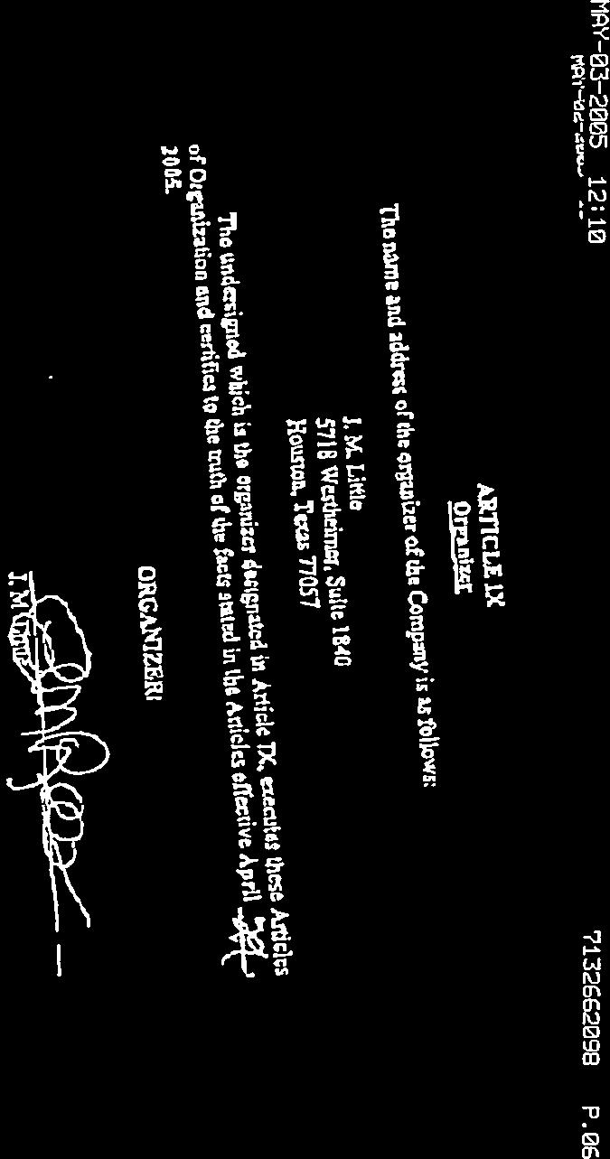
3 PLANNING AND ZONING COMMISSION 1. a. Meeting Date: 10/17/2017 Subject: Consider approving the regular meeting minutes of the September 19, 2017, meeting. Prepared for: Tiffany Foster, Planning and Development Services Prepared by: Nathan Dietrich, Planning and Development Services Information ITEM Consider approving the regular meeting minutes of the September 19, 2017, Planning and Zoning Commission meeting. PREFACE The minutes of the September 19, 2017, Planning and Zoning Commission regular meeting are attached for your review. RECOMMENDATION Staff recommends approval. Minutes Attachments 1

4 CITY OF BAYTOWN PLANNING AND DEVELOPMENT SERVICES MINUTES OF THE PLANNING AND ZONING COMMISSION MEETING September 19, 2017 The Planning and Zoning Commission met at 5:00 p.m. on Tuesday, September 19, 2017, in the Council Chamber at Baytown City Hall located at 2401 Market Street, Baytown, Texas. Members Present: Shawn McDonald Chairman Bo Cox Vice-chairman Pete Côté Member Donna Winfrey-Varner Member Gilbert Chambers Member Spencer Carnes Member Benjamin Boul Member Members Not Present: R.D. Burnside Member Brandon Benoit Member Staff Present: Tiffany Foster Planning Director Nathan Dietrich Senior Planning Manager Chris Chavis Principal Planning Manager Harold Cheek Long Range Planner Shelly Shelton Planner II Chris Guess Planner II Yvonne Briscoe Planner I CALL TO ORDER Chairman Shawn McDonald called the September 19, 2017, Planning and Zoning Commission meeting to order at 5:00 p.m., with a quorum present. 1. MINUTES a. Consider approving the meeting minutes of the August 15, 2017, Planning and Zoning Commission Meeting. Mr. Pete Côté motioned to approve the minutes of the August 15, 2017, Planning and Zoning Commission meeting, seconded by Ms. Donna Winfrey-Varner. Motion PASSED unanimously. 2. PLATS a. Consider approving Trinity Oaks Sec 1. Preliminary Plat, being approximately acres located on the west side of Tri-City Beach Road approximately 2,500 feet south of the intersection of State Highway 99 and Tri-City Beach Road, legally described as acres out of Williams Scott League Abstract 65, Harris County, Baytown, Texas. Mr. Chris Guess summarized the item. Mr. Gil Chambers asked about the elevation of the property. Chairman McDonald chose to revisit Item 2.a. and moved to the next item on the agenda, Item 3.a. 2
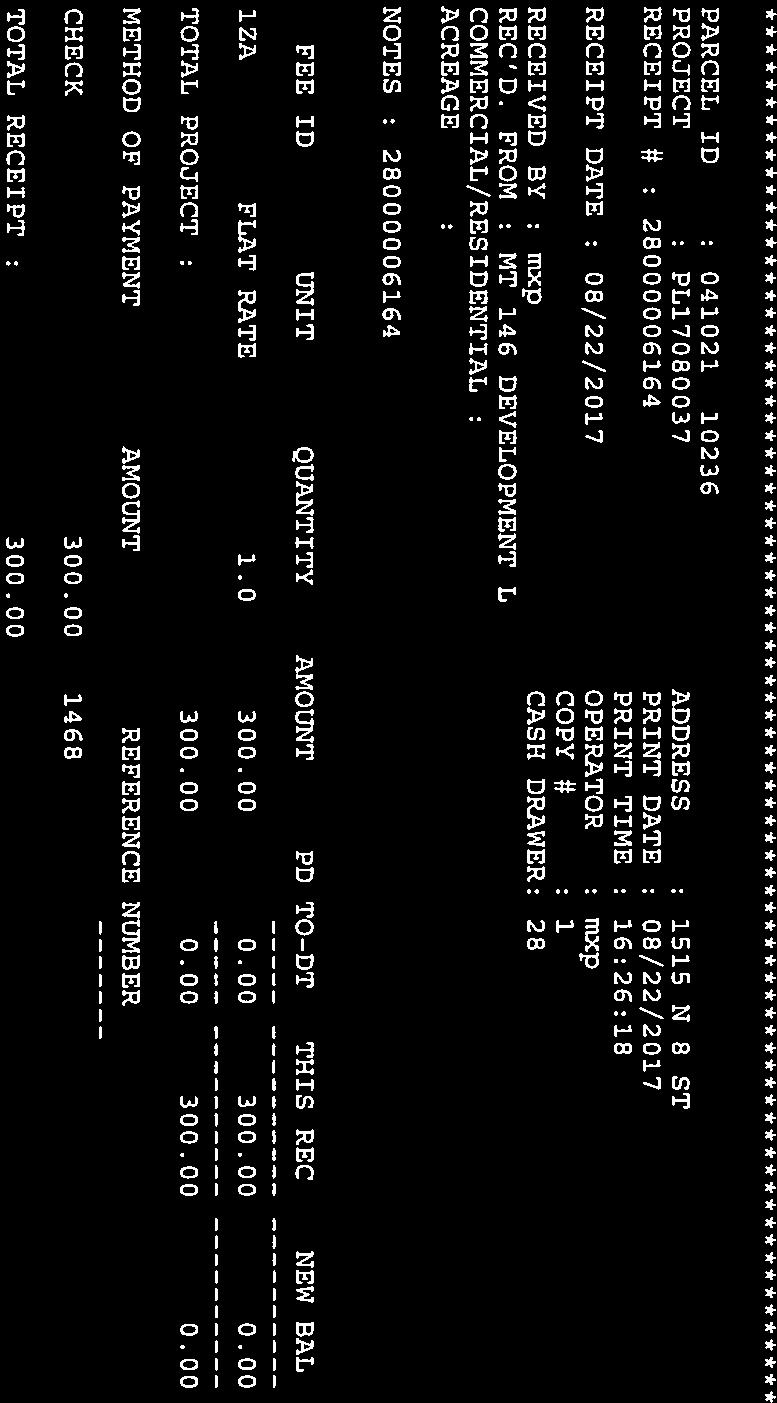
5 3. ZONING a. Conduct the first public hearing concerning a proposed amendment to the official zoning map to rezone approximately 3.48 acres of land, approximately 360 feet north of West Baker Road, legally described as Tract 26 in Lot 6, Abstract No. 44, Nathaniel Lynch Survey, Harris County, Texas, from Neighborhood Serving Commercial (NSC) Zoning District to General Commercial (GC) Zoning District. Ms. Shelly Shelton summarized the item. Chairman McDonald read the public hearing procedures. Ms. Lisa Little, a resident of Lakewood, stated that she is concerned about the precedent that approval of this item would set. She feels that a better plan of how we want Bayway to look is needed. Mr. Al Busch, architect for the project, stated that the intent of the property owner is to consolidate their two tortilla factories that exist on Bayway with their corporate office and construct it all at this location. Ms. Ray Jones does not understand why the property must be rezoned if the two factories already exist; she feels that rezoning to GC would allow many uses that are not good for the neighborhood. Mr. Steven Adrian stated that the street behind the subject property floods; the drainage issue needs to be addressed. He is concerned that changing this property to GC will allow other properties to be zoned GC and that is not good for the area. Chariman McDonald asked if the applicant could build the desired project in the NSC zoning district. Mr. Busch stated that the size of the proposed building is not allowed in NSC. With no one else desiring to speak, Chairman McDonald closed the public hearing. 2. PLATS (continued) Chairman McDonald returned to Item 2.a. Mr. Spencer Carnes motioned to approve the preliminary plat; seconded by Mr. Benjamin Boul. Mr. Chambers asked if part of the plat is in the 100 year floodplain; Mr. Guess answered yes. Mr. Chambers asked if it was the intent of the builder to cut and fill the property; Mr. Guess stated that the method to be used is unknown. Mr. Chambers opposed the plat as he feels the low elevation puts citizens at risk. Ms. Tiffany Foster stated that there are engineering reports that are not complete at this stage in the process; the reports will verify that the project is constructed to comply with all regulations. Mr. Chambers main concern is storm surge. Motion PASSED with all in favor except Mr. Chambers who is opposed to approval of the preliminary plat. b. Conduct the first public hearing concerning a proposed amendment to the official zoning map to rezone approximately 1.14 acres of land, at 708 Peggy Avenue and 1515 N. 8th Street, located on the northwest corner of the intersection of N. Eighth Street and Peggy Avenue, Harris County, Texas, from Mixed Use (MU) Zoning District to Mixed Residential at Low to Medium Densities (SF2) Zoning District. Ms. Shelton summarized the item. Mr. Chambers asked if the proposed Habitat for Humanity houses would comply with masonry standards set forth in the ULDC; Ms. Foster answered yes. 4. DIRECTOR S REPORT Minutes of the September 19, 2017, Planning & Zoning Commission Meeting 2 3
6 a. Present a report regarding action taken by City Council on planning and zoning items. Ms. Tiffany Foster stated that the following item was not heard by the Commission but was approved by City Council: The annexation of San Jacinto area, east of John Martin and north of Cedar Bayou Lynchburg. Although the annexation item was not heard by the Commission, Ms. Foster wanted to keep them abreast of new area added to the City. 5. ADJOURN Chairman McDonald called for the meeting to adjourn at 5:25 p.m. Minutes of the September 19, 2017, Planning & Zoning Commission Meeting 3 4
7 PLANNING AND ZONING COMMISSION 2. a. Meeting Date: 10/17/2017 Subject: Consider - Goose Creek Reserve Section 2B Final Plat Prepared for: Tiffany Foster, Planning and Development Services Prepared by: Shelly Shelton, Planning and Development Services Information ITEM Consider approving Goose Creek Reserve Section 2B Final Plat, located west of Emmett Hutto and south of Country Club View Drive, a subdivision of approximately acres, out of and part of the Harvey Whiting Survey Abstract 840, Harris County, Texas. PREFACE This is the consideration for approval of Goose Creek Reserve Section 2B Final Plat, formerly the Goose Creek Golf Course and Country Club. The purpose of the plat is to create 82 single-family residential lots in four (4) blocks and three (3) reserves. This is the fourth phase in the development. The application has been reviewed by the Development Review Committee, which found that the application met the minimum requirements of the Code of Ordinances. The application, plat and supporting documentation are attached for your review. RECOMMENDATION Staff recommends approval. Application and Supporting Documents Vicinity Map Plat Sheet 1 Plat Sheet 2 Attachments 5


8 9/21/17 9/19/17 6

9 7

10 8

11 9
12 10


13 CARRIAGE LN COACHMAN DR FAIRWAY DR HOMEWOOD SOMERSET DR TAMARACH DR GOOSE CREEK DR INVERNESS DR ASHWOOD DR LN GLEN HAVEN DR GOOSE CREEK DR CREEK RIPPLE DR COUNTRY CLUB DR COUNTRY CLUB VIEW DR ** SPECKLEBELLY DR PROPOSED 9 Sec 4 ** WOODSTONE DR! CLUB DR ** COUNTRY W BAKER RD ** MAGELLAN RIDGE LN Sec 5 ** HYBRID CT SKOKIE LN! W BAKER RD Sec 3 QUAIL HOLLOW DR Sec2B BURNING TREE DR ST ANDREW DR ** MAGELLAN RIDGE LN ** PROPOSED 4 CT ** BARNACLE ** EMPORER VALLEY LN GOOSE CT! ** EGYPTIAN SPURWING LN Sec 2A!!!! CAPE BARREN LN GREYLAG CT Sec 1B CANADIAN GOOSE LN! CACKLING GOOSE CT! BROOKE DR IRONWOOD DR BUSH RD MANOR DR CYNDA! CT SUMMERLIN SANTEE CIR W BAKER RD SAWGRASS DR GOOSE SANTEE DR TEE DR GREEN CREEK PARK DR RAM ROCK DR APPLERO CK DR ALAMANCE DR EMMETT HUTTO BLVD EMMETT HUTTO BLVD LEGEND Subject Property City Limit µ Goose Creek Reserve Section 2B Vicinity Map CREEK DR GOOSE PEBBLE BROOK ST OAK HOLLOW ST CT FOREST BRIAR CT GATE GATE ROLLINGBROOK DR DECKER DR SS 330 DECKER DR SS 330 INDIAN TRL BRAMBLE CREEK DR SHADY HILL DR DR ROLLINGBROOK ROLLINGCREEK DR Document Path: G:\Maps_By_Baytown\Planning Staff\Emmett_Hutto_blvd_3919_Goose_Creek_Reserve_sub\Goose_Creek_Reserve_Sec_2B\GIS\Goose_Creek_Reserve_2B_8-5x11L_ _Yellow_Locater.mxd The City of Baytown Texas makes no warranty, representation, or guarantee regarding the accuracy of this map. This map is intended for display purposes only and does not replace official recorded documents. 1 inch = 667 feet Date
14 N VICINITY MAP GOOSE CREEK RESERVE SECTION 2B FINAL PLAT GBI PARTNERS, L.P. LAND SURVEYING CONSULTANTS S. GESSNER RD. MISSOURI CITY, TX PHONE: TBPLS FIRM # D.R. HORTON-TEXAS, LTD. A TEXAS LIMITED PARTNERSHIP LJA Engineering, Inc W. Grand Parkway North Phone Suite 100 Fax Katy, Texas FRN-F
15 N N VICINITY MAP GOOSE CREEK RESERVE SECTION 2B FINAL PLAT GBI PARTNERS, L.P. LAND SURVEYING CONSULTANTS S. GESSNER RD. MISSOURI CITY, TX PHONE: TBPLS FIRM # D.R. HORTON-TEXAS, LTD. A TEXAS LIMITED PARTNERSHIP LJA Engineering, Inc W. Grand Parkway North Phone Suite 100 Fax Katy, Texas FRN-F
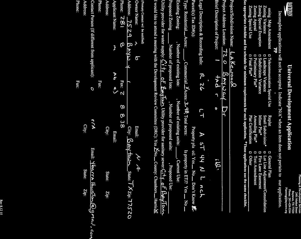
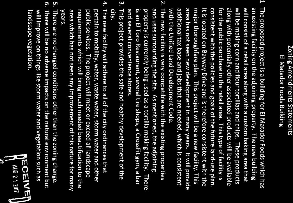
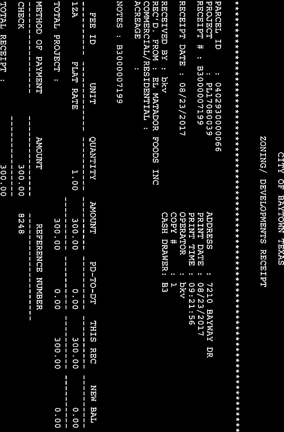
16 PLANNING AND ZONING COMMISSION 3. a. Meeting Date: 10/17/2017 Subject: Second Public Hearing - Zoning Map Amendment from NSC to GC Prepared for: Tiffany Foster, Planning and Development Services Prepared by: Shelly Shelton, Planning and Development Services Information ITEM Conduct the second public hearing concerning a proposed amendment to the official zoning map to rezone approximately 3.48 acres of land, approximately 360 feet north of West Baker Road, legally described as Tract 26 in Lot 6, Abstract No. 44, Nathaniel Lynch Survey, Harris County, Texas, from Neighborhood Serving Commercial (NSC) Zoning District to General Commercial (GC) Zoning District. PREFACE This is the second public hearing regarding the rezoning of approximately 3.48 acres, approximately 360 feet north of West Baker Road. The applicant is proposing to rezone vacant and undeveloped property to build a new manufacturing facility. The property owner has been a partner in a facility that consists of tortilla, tortilla chip, salsa and other Mexican food manufacturing next door at 7201 Bayway Drive. The new facility will manufacture the Mexican food products and house an office, storage and some retail space for the sale of the goods to the general public. The proposed use, manufacturing is not permitted in the NSC Zoning District and by nature the NSC Zoning District does not lend itself to the land uses appropriate for large tracts and/ or bigger swaths of land, which prompted the request to rezone the subject property to GC as manufacturing is permitted with conditions. Additionally, the GC Zoning District designation would allow a larger tract like the subject property to be developed at its full potential. The FLUP is the component of the Baytown 2025 Comprehensive Plan used to guide decision making with regard to growth management and development. On the FLUP, the subject property is designated as part of a Commercial Corridor area. The request to rezone to GC is consistent with the FLUP. The application, supporting documentation, and staff report are attached for your review. RECOMMENDATION Application and supporting documentation Notice Area Map Proposed Zoning Staff Report Attachments 14


17 15
18 16
19 17

20 18
21 19
22 20

 MAYHAW DR BURNETT DR MU (Mixed Use) NSC (Neighborhood Serving Commercial) OR (Open Space/Recreation) SF1 (Low Density Single-Fam. Res.) W BAKER RD SF2 (Mixed Res. Low/Med. Density) SFE (Single-Fam.")
23 TIMBER LN WILDWOOD DR WILDROSE DR SF1 LI µ Notification Area El Matador Foods Rezoning of Approximately 3.48 Acres from NSC to GC LEGEND SF1 HACKBERRY LN MEADOR LN PETTERSON ST BAYWAY DR Subject Property Properties to be notified 300 Property Selection Zone Zoning Districts ACE (Arts, Cultural and Entertainment) GC (General Commercial) HI (Heavy Industrial) LC (Livable Center) NSC GC LI (Light Industrial) MF1 (Med. Density Mixed Res.) MF2 (Mid-Rise Mixed Res.) MF3 (High Density Mixed Res.) MAYHAW DR BURNETT DR MU (Mixed Use) NSC (Neighborhood Serving Commercial) OR (Open Space/Recreation) SF1 (Low Density Single-Fam. Res.) W BAKER RD SF2 (Mixed Res. Low/Med. Density) SFE (Single-Fam. Estate) UN (Urban Neighborhood) MAYHAW DR MU LAKEWOOD DR GREENBRIAR DR MAYHAW DR LAKEWOOD DR 1 inch = 333 feet Document Path: Q:\GIS\Maps_By_Baytown\Planning Staff\Bayway_Dr_7210_Rezoning_ \GIS\Bayway_Dr_7210_Rezoning_ mxd MU The City of Baytown Texas makes no warranty, representation, or guarantee regarding the accuracy of this map. This map is intended for display purposes only and does not replace official recorded documents. Date
24 TIMBER LN WILDWOOD DR WILDROSE DR SF1 NSC LI µ Proposed GC El Matador Foods Rezoning of Approximately 3.48 Acres from NSC to GC LEGEND SF1 PETTERSON ST NSC Subject Property Zoning Districts ACE (Arts, Cultural and Entertainment) GC (General Commercial) HACKBERRY LN MEADOR LN HI (Heavy Industrial) LC (Livable Center) LI (Light Industrial) BAYWAY DR MF1 (Med. Density Mixed Res.) GC GC MF2 (Mid-Rise Mixed Res.) MF3 (High Density Mixed Res.) MU (Mixed Use) MAYHAW DR NSC NSC (Neighborhood Serving Commercial) OR (Open Space/Recreation) SF1 (Low Density Single- Fam. Res.) W BAKER RD SF2 (Mixed Res. Low/Med. Density) SFE (Single-Fam. Estate) MAYHAW DR BURNETT DR UN (Urban Neighborhood) MU LAKEWOOD DR MU GREENBRIAR DR MAYHAW DR LAKEWOOD DR Document Path: Q:\GIS\Maps_By_Baytown\Planning Staff\Bayway_Dr_7210_GC_ mxd The City of Baytown Texas makes no warranty, representation, or guarantee regarding the accuracy of this map. This map is intended for display purposes only and does not replace official recorded documents. 1 inch = 333 feet Date
25 Zoning Map Amendment El Matador Foods Staff Report Requested Action: Zoning Map Amendment to the official zoning map to rezone approximately 3.48 acres from Neighborhood Serving Commercial (NSC) Zoning District to General Commercial (GC) Zoning District. Applicant: John Ybarra Subject Property: Is approximately 3.48 acres of land, approximately 360 feet north of West Baker Road, legally described as Tract 26 in Lot 6, Abstract No. 44, Nathaniel Lynch Survey, Harris County, Texas. Parcel Information Current Use: Vacant Proposed Use: Light Manufacturing and Retail Future Land Use Plan: Commercial Corridor Adjacent Parcel Information North: Exxon Pipeline right-of-way, Garages (mechanic), NSC South: El Matador Tortilla Factory, NSC East: Bayway Drive right-of-way West: Meador Lane right-of-way Staff Analysis (Background): The applicant is proposing to rezone vacant and undeveloped property to build a new manufacturing facility. The property owner has been a partner in a facility that consists of tortilla, tortilla chip, salsa and other Mexican food manufacturing next door at 7201 Bayway Drive. The new facility will manufacture the Mexican food products and house an office, storage and some retail space for the sale of the goods to the general public. The proposed use, manufacturing is not permitted in the NSC Zoning District and by nature the NSC Zoning District does not lend itself to the land uses appropriate for large tracts and/ or bigger swaths of land, which prompted the request to rezone the subject property to GC as light manufacturing is permitted with conditions. Additionally, the GC Zoning District designation would allow a larger tract like the subject property to be developed at its full potential. As Bayway Drive is a minor arterial, it is an appropriate location for commercial land uses. However, Meador Lane would not be appropriate for heavy truck access to an industrial land use. In order to recommend approval of an application for a zoning amendment, the Planning and Zoning Commission shall consider the following factors: 1. Consistency with guiding documents. The FLUP is the component of the Baytown 2025 Comprehensive Plan used to guide decision making with regard to growth management and development. On the FLUP, 23
26 the subject property is designated as part of a Commercial Corridor. The request to change the subject property zoning designation to GC is consistent with the Land Use Narratives for the FLUP. Commercial Corridors (Red) May accommodate all types of commercial activity, including big box, medical services, restaurants, entertainment, offices, and large multi-family development. Corridors of commercial activities with variable depths along or near major arterials and freeways. Improved traffic mobility by discouraging continuous commercial strips with numerous driveways along major streets. Commercial corridor proposed along the east side of Wade Road, south of IH 10, as a buffer between existing rail yards west of Wade Road and proposed residential use to the east toward Goose Creek. 2. Compatible with the Surrounding Area. The conditions for light manufacturing land uses in GC serve to ensure that there are no compatibility issues with the surrounding land uses. 3. Promotion of health, safety, or general welfare. Appropriately locating commercial land uses on arterials, including Bayway Drive promotes the basic health, safety and welfare of the City of Baytown. Bayway Drive provides connectivity to other local businesses, which promotes and encourages a healthy economy. 4. Facilitation of infrastructure. Adequate public facilities are available to the subject property, including Bayway Drive, water and waste water. If any infrastructure needs to be extended or capacity has to be added due to the future development of the subject property, the developer must finance it. 5. There are changed conditions. Recently, City Staff analyzed the land uses along Bayway Drive from SH 330 to Crow Road. The analysis was prompted by an increase in development in Baytown. The FLUP designated the properties along Bayway Drive as Low Density Residential. The City sponsored FLUP amendment-to change Bayway Drive s designation to a Commercial Corridor-were presented to the City of Baytown Planning and Zoning Commission and the City Council: the FLUP Amendment was approved. 6. Effect on natural environment. The proposed project will develop a greenfield site. The development will be required to mitigate any drainage issues that may arise due to the increased impervious surface. 7. Community need. 24
27 This parcel is ripe for development, as it has frontage on an arterial and existing utilities. Additionally, these same attributes make the parcel a prime candidate for development at a scale beyond what would be permitted by the regulations set forth in the NSC Zoning District, e.g. buildings are limited to 10,000 square feet. The 10,000 square foot limitation does not make sense for development for large swaths of land on arterials but rather smaller lots surrounded by neighborhoods. Appropriate development in the NSC Zoning District is a barbershop or a mom and pop grocery store. The economic development (growth) of the community is important, as the other options are stasis or decline. Retaining our local growing businesses in Baytown is a basic tenet of economics and sustainable economic development. Taking measures to allow our industries to flourish in our local economy is imperative to our success as a thriving economy. Additionally, the more local businesses we have that are sustainable the deeper our economy is and the less susceptible it is to the ups and downs of outside influences, which intern benefits all of us. 25
28 PLANNING AND ZONING COMMISSION 3. b. Meeting Date: 10/17/2017 Subject: Consider - Zoning Map Amendment from NSC to GC Prepared for: Tiffany Foster, Planning and Development Services Prepared by: Shelly Shelton, Planning and Development Services Information ITEM Consider making a recommendation and preparing a report concerning a proposed amendment to the official zoning map to rezone approximately 3.48 acres of land, approximately 360 feet north of West Baker Road, legally described as Tract 26 in Lot 6, Abstract No. 44, Nathaniel Lynch Survey, Harris County, Texas, from Neighborhood Serving Commercial (NSC) Zoning District to General Commercial (GC) Zoning District. PREFACE This is the consideration item regarding the rezoning of approximately 3.48 acres, approximately 360 feet north of West Baker Road. The applicant is proposing to rezone vacant and undeveloped property to build a new manufacturing facility. The property owner has been a partner in a facility that consists of tortilla, tortilla chip, salsa and other Mexican food manufacturing next door at 7201 Bayway Drive. The new facility will manufacture the Mexican food products and house an office, storage and some retail space for the sale of the goods to the general public. The proposed use, manufacturing is not permitted in the NSC Zoning District and by nature the NSC Zoning District does not lend itself to the land uses appropriate for large tracts and/ or bigger swaths of land, which prompted the request to rezone the subject property to GC as manufacturing is permitted with conditions. Additionally, the GC Zoning District designation would allow a larger tract like the subject property to be developed at its full potential. The FLUP is the component of the Baytown 2025 Comprehensive Plan used to guide decision making with regard to growth management and development. On the FLUP, the subject property is designated as part of a Commercial Corridor area. The request to rezone to GC is consistent with the FLUP. The application, supporting documentation, and staff report are attached to the previous agenda item for your review. The Planning and Zoning Commission's Report to City Council is attached for your consideration. RECOMMENDATION 26
29 P&Z Report to City Council Attachments 27
30 PLANNING AND ZONING COMMISSION REPORT TO City COUNCIL TO: City Council FROM: Planning and Zoning Commission RE: Zoning Map Amendment from NSC to GC DATE: October 17, 2017 This is the report required to be submitted by the Planning and Zoning Commission per Section 1.26 of the Unified Land Development Code, Baytown Code of Ordinances to the City Council. This report also serves as the final report that is to be used by the Council in its consideration of the amendment as set forth in Section 1.26 of the code. Requested Action: Zoning Map Amendment to the official zoning map to rezone approximately 3.48 acres from Neighborhood Serving Commercial (NSC) Zoning District to General Commercial (GC) Zoning District. Applicant: John Ybarra Subject Property: Is approximately 3.48 acres of land, approximately 360 feet north of West Baker Road, legally described as Tract 26 in Lot 6, Abstract No. 44, Nathaniel Lynch Survey, Harris County, Texas. Parcel Information Current Use: Vacant Proposed Use: Light Manufacturing and Retail Future Land Use Plan: Commercial Corridor Adjacent Parcel Information North: Exxon Pipeline right-of-way, Garages (mechanic), NSC South: El Matador Tortilla Factory, NSC East: Bayway Drive right-of-way West: Meador Lane right-of-way Staff Analysis (Background): The applicant is proposing to rezone vacant and undeveloped property to build a new manufacturing facility. The property owner has been a partner in a facility that consists of tortilla, tortilla chip, salsa and other Mexican food manufacturing next door at 7201 Bayway Drive. The new facility will manufacture the Mexican food products and house an office, storage and some retail space for the sale of the goods to the general public. 28
31 The proposed use, manufacturing is not permitted in the NSC Zoning District and by nature the NSC Zoning District does not lend itself to the land uses appropriate for large tracts and/ or bigger swaths of land, which prompted the request to rezone the subject property to GC as light manufacturing is permitted with conditions. Additionally, the GC Zoning District designation would allow a larger tract like the subject property to be developed at its full potential. As Bayway Drive is a minor arterial, it is an appropriate location for commercial land uses. However, Meador Lane would not be appropriate for heavy truck access to an industrial land use. In order to recommend approval of an application for a zoning amendment, the Planning and Zoning Commission shall consider the following factors: 1. Consistency with guiding documents. The FLUP is the component of the Baytown 2025 Comprehensive Plan used to guide decision making with regard to growth management and development. On the FLUP, the subject property is designated as part of a Commercial Corridor. The request to change the subject property zoning designation to GC is consistent with the Land Use Narratives for the FLUP. Commercial Corridors (Red) May accommodate all types of commercial activity, including big box, medical services, restaurants, entertainment, offices, and large multi-family development. Corridors of commercial activities with variable depths along or near major arterials and freeways. Improved traffic mobility by discouraging continuous commercial strips with numerous driveways along major streets. Commercial corridor proposed along the east side of Wade Road, south of IH 10, as a buffer between existing rail yards west of Wade Road and proposed residential use to the east toward Goose Creek. 2. Compatible with the Surrounding Area. The conditions for light manufacturing land uses in GC serve to ensure that there are no compatibility issues with the surrounding land uses. 3. Promotion of health, safety, or general welfare. Appropriately locating commercial land uses on arterials, including Bayway Drive promotes the basic health, safety and welfare of the City of Baytown. Bayway Drive provides connectivity to other local businesses, which promotes and encourages a healthy economy. 29
32 4. Facilitation of infrastructure. Adequate public facilities are available to the subject property, including Bayway Drive, water and wastewater. If any infrastructure needs to be extended or capacity has to be added due to the future development of the subject property, the developer must finance it. 5. There are changed conditions. Recently, City Staff analyzed the land uses along Bayway Drive from SH 330 to Crow Road. The analysis was prompted by an increase in development in Baytown. The FLUP designated the properties along Bayway Drive as Low Density Residential. The City sponsored FLUP amendment-to change Bayway Drive s designation to a Commercial Corridor-were presented to the City of Baytown Planning and Zoning Commission and the City Council: the FLUP Amendment was approved. 6. Effect on natural environment. The proposed project will develop a greenfield site. The development will be required to mitigate any drainage issues that may arise due to the increased impervious surface. 7. Community need. This parcel is ripe for development, as it has frontage on an arterial and existing utilities. Additionally, these same attributes make the parcel a prime candidate for development at a scale beyond what would be permitted by the regulations set forth in the NSC Zoning District, e.g. buildings are limited to 10,000 square feet. The 10,000 square foot limitation does not make sense for development for large swaths of land on arterials but rather smaller lots surrounded by neighborhoods. Appropriate development in the NSC Zoning District is a barbershop or a mom and pop grocery store. The economic development (growth) of the community is important, as the other options are stasis or decline. Retaining our local growing businesses in Baytown is a basic tenet of economics and sustainable economic development. Taking measures to allow our industries to flourish in our local economy is imperative to our success as a thriving economy. Additionally, the more local businesses we have that are sustainable the deeper our economy is and the less susceptible it is to the ups and downs of outside influences, which intern benefits all of us. The Commission recommends approval / disapproval of the proposed zoning map amendment from NSC to GC on the 17th day of October, Shawn McDonald, Chairman City of Baytown, Texas Planning and Zoning Commission 30
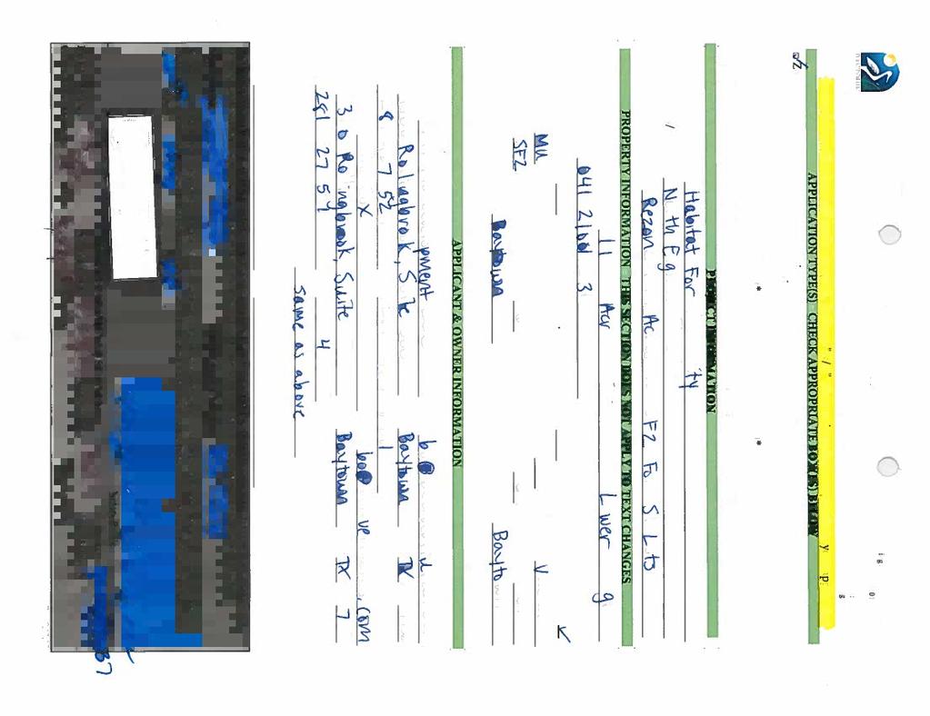
33 PLANNING AND ZONING COMMISSION 3. c. Meeting Date: 10/17/2017 Subject: Second Public Hearing - Zoning Map Amendment from MU to SF2 Prepared for: Tiffany Foster, Planning and Development Services Prepared by: Shelly Shelton, Planning and Development Services Information ITEM Conduct the second public hearing concerning a proposed amendment to the official zoning map to rezone approximately 1.14 acres of land at 708 Peggy Avenue and 1515 North 8th Street, located on the northwest corner of the intersection of North 8th Street and Peggy Avenue, Harris County, Texas, from Mixed Use (MU) Zoning District to Mixed Residential at Low to Medium Densities (SF2) Zoning District. PREFACE This is the second public hearing regarding the rezoning of approximately 1.14 acres of land at 708 Peggy Avenue and 1515 North 8th Street, located on the northwest corner of the intersection of North 8th Street and Peggy Avenue. The subject property is vacant and undeveloped. The goal is to donate this property to Habitat for Humanity who plans to build six (6) single-family homes on the subject property, which consists of a little over one (1) acre. The proposed development meets the density regulations set forth in the SF2 Zoning District. Currently, the zoning designation is MU, which permits a variety of land uses, including residential; however, single-family residential land uses in MU have conditions. As set forth in the Unified Land Development Code (ULDC), one of the conditions is rezoning to an appropriate single-family zoning district, which is the purpose of the request to change the zoning designation to SF2. The Future Land Use Plan (FLUP) is the component of the Baytown 2025 Comprehensive Plan used to guide decision making with regard to growth management and development. The subject property is designated as Low-Medium Density Residential District on the FLUP.The request is consistent with the Low-Medium Density Residential District Land Use Narratives for the FLUP. The application, supporting documentation, and staff report are attached for your review. RECOMMENDATION This is the second public hearing. Application and Supporting Documents Attachments 31
34 Notification Area Map Proposed Zoning Staff Report 32


35 33

36 34

37 35


38 36
39 37
40 38
41 39
42 SF2 NSC MU BEAUMONT RD MU µ Notification Area 708 Peggy Ave 1515 N. 8th St N 6TH ST SF2 WARD RD Rezoning of Approximately 1.14 Acres from MU to SF2 LEGEND MU Subject Property 300_Property_Selection_Zone_ Property Selection Zone Zoning Districts ACE (Arts, Cultural and Entertainment) PEGGY AVE N 7TH ST SF2 MU MU GC (General Commercial) HI (Heavy Industrial) LC (Livable Center) LI (Light Industrial) MF1 (Med. Density Mixed Res.) MF2 (Mid-Rise Mixed Res.) MF3 (High Density Mixed Res.) PEARL AVE SF2 SF2 PEGGY AVE N 8TH ST PEGGY AVE N ALEXANDER DR N ALEXANDER DR MU (Mixed Use) NSC (Neighborhood Serving Commercial) OR (Open Space/Recreation) SF1 (Low Density Single-Fam. Res.) SF2 (Mixed Res. Low/Med. Density) SFE (Single-Fam. Estate) UN (Urban Neighborhood) CenterlineMaster_ PEARL AVE RUTH AVE 1 inch = 127 feet Document Path: Q:\GIS\Maps_By_Baytown\Planning Staff\Peggy_Ave_708_Rezoning_ \GIS\Peggy_Ave_708_Rezoning_ mxd The City of Baytown Texas makes no warranty, representation, or guarantee regarding the accuracy of this map. This map is intended for display purposes only and does not replace official recorded documents. Date
43 SF2 NSC MU BEAUMONT RD MU µ Proposed SF2 708 Peggy Ave 1515 N. 8th St N 6TH ST SF2 WARD RD Rezoning of Approximately 1.14 Acres from MU to SF2 MU LEGEND Subject Property Zoning Districts ACE (Arts, Cultural and Entertainment) PEGGY AVE N 7TH ST SF2 MU GC (General Commercial) HI (Heavy Industrial) LC (Livable Center) LI (Light Industrial) MF1 (Med. Density Mixed Res.) MF2 (Mid-Rise Mixed Res.) MF3 (High Density Mixed Res.) PEARL AVE SF2 SF2 PEGGY AVE N 8TH ST PEGGY AVE N ALEXANDER DR N ALEXANDER DR MU (Mixed Use) NSC (Neighborhood Serving Commercial) OR (Open Space/Recreation) SF1 (Low Density Single-Fam. Res.) SF2 (Mixed Res. Low/Med. Density) SFE (Single-Fam. Estate) UN (Urban Neighborhood) CenterlineMaster_ PEARL AVE RUTH AVE 1 inch = 127 feet Document Path: Q:\GIS\Maps_By_Baytown\Planning Staff\Peggy_Ave_708_Rezoning_ \GIS\Peggy_Ave_708_SF2_ mxd The City of Baytown Texas makes no warranty, representation, or guarantee regarding the accuracy of this map. This map is intended for display purposes only and does not replace official recorded documents. Date
44 Zoning Map Amendment 708 Peggy Ave and 1515 N. 8 th Street Staff Report Requested Action: Zoning Map Amendment to the official zoning map to rezone approximately 1.14 acres from Mixed Use (MU) Zoning District to Mixed residential at low to medium densities (SF2) Zoning District. Applicant: James Cox Subject Property: Is approximately 1.14 acres of land at 708 Peggy Avenue and 1515 N. Eighth Street, located on the northwest corner of the intersection of N. Eighth Street and Peggy Avenue, Harris County, Texas. Parcel Information Current Use: Vacant and undeveloped Proposed Use: Single-family residential Future Land Use Plan: Low-Medium Density Residential Adjacent Parcel Information North: Single-Family Residential Development (MU) South: Single-Family Residential Development (SF2) East: Commercial (MU) West: Single-Family Residential Development (SF2) Staff Analysis (Background): The subject property is vacant and undeveloped. The goal is to donate this property to Habitiat for Humanity who plans to build six (6) single-family homes on the subject property, which consists of a little over one (1) acre. The proposed development meets the density regulations set forth in the SF2 Zoning District. Currently, the zoning designation is MU, which permits a variety of land uses, including residential; however, single-family residential land uses in MU have conditions. As set forth in the ULDC, one of the conditions is rezoning to an appropriate single-family zoning district, which is the purpose of the request to change the zoning designation to SF2. In order to recommend approval of an application for a zoning amendment, the Planning and Zoning Commission shall consider the following factors: 1. Consistency with guiding documents. The FLUP is the component of the Baytown 2025 Comprehensive Plan used to guide decision making with regard to growth management and development. The subject property is designated as Low-Medium Density Residential District on the Future Land Use Plan (FLUP). The request is consistent with the Low-Medium Density Residential District Land Use Narratives for the FLUP. Low-Medium Density Residential (Peach) 42
45 Includes a range of existing residential uses from rural residential to limited multi-family residential. Primarily conventional, single-family detached dwellings and manufactured housing on platted lots; smaller lots are satisfactory if common open space is provided. The scale and mass of any multi-family development should be reviewed and considered for compatibility to neighboring uses. Uses including places of assembly, schools, parks, and other community facilities such as libraries with pedestrian links to residential. Commercial that serves neighborhoods not regions, such as office buildings, and neighborhood services to support and compliment residential area. Small-scale, neighborhood commercial located within a convenient walking distance of residences and buffered when adjacent to a residential use. Appropriate area for pedestrian and bicycle-friendly streets. Medium density development along perimeter of neighborhoods and generally along collector streets. This proposed zoning change is also consistent with Baytown s Vision Statement, To be a community that celebrates families and community interaction by ensuring diverse and high-quality opportunities for housing, employment, education, and recreation. The developer proposes building new homes in an established area. This affords homeownership opportunities in an established neighborhood and provides infill development. This development fulfills the vision of the Comprehensive Plan, Plan Element Goals for Land Use Development patterns resulting in the efficient use of land, infrastructure, and fiscal resources as this project is infill development since there are public facilities available. Additionally, infill development meets some of the City s Infrastructure Policies for Growth Capacity in the Comprehensive Plan e.g., To encourage development in close proximity to existing infrastructure. As a City it is crucial to steer growth to areas where there are adequate public facilities in order to capitalize upon existing vs. future resources. We as the City are trying to manage these resources rather than continuing the leapfrog development that stresses our resources. 2. Compatible with the Surrounding Area. With regard to the surrounding area, the existing development is mostly residential so the proposed homes would be compatible and there would not be any adverse effect on existing development. Further, this development may have a positive impact as Habitat for Humanity requires homeowners to contribute sweat equity-they contribute by taking part in the construction of their own homes-so there is deep-rooted pride in ownership that helps to revitalize neighborhoods and communities, as there is a sense of belonging. 3. Promotion of health, safety, or general welfare. Section 1-1 states The purpose of the Unified Land Development Code is to promote the health, safety and general welfare by promoting safe, orderly and economical 43
46 sustainable development. The purpose of the code will be met, as the proposed development will comply with all ordinances ensuring that concerns with regard to health and safety are followed. The proposed homes will promote the general welfare as the location has public facilities, which is far more sustainable than development along the fringe. 4. Facilitation of infrastructure. As stated above, this development is proposed along existing roadways with existing infrastructure. 5. There are changed conditions. The City of Baytown has grown so the need for more housing and housing options has increased. 6. Effect on natural environment. The proposed housing will develop a greenfield site, but has limited impact on the natural environment other than a decrease in the pervious surface. However, the limitations on the lot coverage in the ULDC provide some mitigation with regard to the amount of impervious allowed in the SF2 Zoning District. The maximum lot coverage in SF2 is 60 percent. 7. Community need. Granting the zoning change will allow development in an area that needs revitalization. The rezoning also supports Habitat for Humanity s mission to provide home ownership opportunities in the City of Baytown. 44
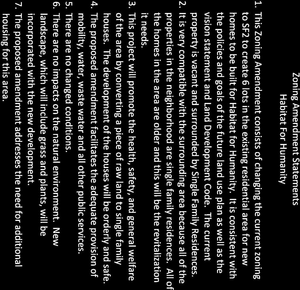
47 PLANNING AND ZONING COMMISSION 3. d. Meeting Date: 10/17/2017 Subject: Consider - Zoning Map Amendment for approximately from MU to SF2. Prepared for: Tiffany Foster, Planning and Development Services Prepared by: Shelly Shelton, Planning and Development Services Information ITEM Consider making a recommendation and preparing a report concerning a proposed amendment to the official zoning map to rezone approximately 1.14 acres of land, at 708 Peggy Avenue and 1515 N. 8th Street, located on the northwest corner of the intersection of N. Eighth Street and Peggy Avenue, Harris County, Texas, from Mixed Use (MU) Zoning District to Mixed Residential at Low to Medium Densities (SF2) Zoning District. PREFACE This is the consideration item regarding the rezoning of approximately 1.14 acres of land, at 708 Peggy Avenue and 1515 N. 8th Street, located on the northwest corner of the intersection of N. Eighth Street and Peggy Avenue. The subject property is vacant and undeveloped. The goal is to donate this property to Habitat for Humanity who plans to build six (6) single-family homes on the subject property, which consists of a little over one (1) acre. The proposed development meets the density regulations set forth in the SF2 Zoning District.Currently, the zoning designation is MU, which permits a variety of land uses, including residential; however, single-family residential land uses in MU have conditions. As set forth in the ULDC, one of the conditions is rezoning to an appropriate single-family zoning district, which is the purpose of the request to change the zoning designation to SF2. The FLUP is the component of the Baytown 2025 Comprehensive Plan used to guide decision making with regard to growth management and development. The subject property is designated as Low-Medium Density Residential District on the Future Land Use Plan (FLUP).The request is consistent with the Low-Medium Density Residential District Land Use Narratives for the FLUP. The application, supporting documentation, and staff report are attached to the previous agenda item for your review. The Planning and Zoning Commission's Report to City Council is attached for your consideration. RECOMMENDATION P & Z Report to City Council Attachments 45
48 PLANNING AND ZONING COMMISSION REPORT TO City COUNCIL TO: City Council FROM: Planning and Zoning Commission RE: Zoning Map Amendment from MU to SF2 DATE: October 17, 2017 This is the report required to be submitted by the Planning and Zoning Commission per Section 1.26 of the Unified Land Development Code, Baytown Code of Ordinances to the City Council. This report also serves as the final report that is to be used by the Council in its consideration of the amendment as set forth in Section 1.26 of the code. Requested Action: Zoning Map Amendment to the official zoning map to rezone approximately 1.14 acres from Mixed Use (MU) Zoning District to Mixed residential at low to medium densities (SF2) Zoning District. Applicant: James Cox Subject Property: Is approximately 1.14 acres of land at 708 Peggy Avenue and 1515 N. Eighth Street, located on the northwest corner of the intersection of N. Eighth Street and Peggy Avenue, Harris County, Texas. Parcel Information Current Use: Vacant and undeveloped Proposed Use: Single-family residential Future Land Use Plan: Low-Medium Density Residential Adjacent Parcel Information North: Single-Family Residential Development (MU) South: Single-Family Residential Development (SF2) East: Commercial (MU) West: Single-Family Residential Development (SF2) Staff Analysis (Background): The subject property is vacant and undeveloped. The goal is to donate this property to Habitiat for Humanity who plans to build six (6) single-family homes on the subject property, which consists of a little over one (1) acre. The proposed development meets the density regulations set forth in the SF2 Zoning District. Currently, the zoning 46
49 designation is MU, which permits a variety of land uses, including residential; however, single-family residential land uses in MU have conditions. As set forth in the ULDC, one of the conditions is rezoning to an appropriate single-family zoning district, which is the purpose of the request to change the zoning designation to SF2. In order to recommend approval of an application for a zoning amendment, the Planning and Zoning Commission shall consider the following factors: 1. Consistency with guiding documents. The FLUP is the component of the Baytown 2025 Comprehensive Plan used to guide decision making with regard to growth management and development. The subject property is designated as Low-Medium Density Residential District on the Future Land Use Plan (FLUP). The request is consistent with the Low-Medium Density Residential District Land Use Narratives for the FLUP. Low-Medium Density Residential (Peach) Includes a range of existing residential uses from rural residential to limited multi-family residential. Primarily conventional, single-family detached dwellings and manufactured housing on platted lots; smaller lots are satisfactory if common open space is provided. The scale and mass of any multi-family development should be reviewed and considered for compatibility to neighboring uses. Uses including places of assembly, schools, parks, and other community facilities such as libraries with pedestrian links to residential. Commercial that serves neighborhoods not regions, such as office buildings, and neighborhood services to support and compliment residential area. Small-scale, neighborhood commercial located within a convenient walking distance of residences and buffered when adjacent to a residential use. Appropriate area for pedestrian and bicycle-friendly streets. Medium density development along perimeter of neighborhoods and generally along collector streets. This proposed zoning change is also consistent with Baytown s Vision Statement, To be a community that celebrates families and community interaction by ensuring diverse and high-quality opportunities for housing, employment, education, and recreation. The developer proposes building new homes in an established area. This affords homeownership opportunities in an established neighborhood and provides infill development. This development fulfills the vision of the Comprehensive Plan, Plan Element Goals for Land Use Development patterns resulting in the efficient use of land, infrastructure, and fiscal resources as this project is infill development since there are public facilities 47
50 available. Additionally, infill development meets some of the City s Infrastructure Policies for Growth Capacity in the Comprehensive Plan e.g., To encourage development in close proximity to existing infrastructure. As a City it is crucial to steer growth to areas where there are adequate public facilities in order to capitalize upon existing vs. future resources. We as the City are trying to manage these resources rather than continuing the leapfrog development that stresses our resources. 2. Compatible with the Surrounding Area. With regard to the surrounding area, the existing development is mostly residential so the proposed homes would be compatible and there would not be any adverse effect on existing development. Further, this development may have a positive impact as Habitat for Humanity requires homeowners to contribute sweat equity-they contribute by taking part in the construction of their own homes-so there is deep-rooted pride in ownership that helps to revitalize neighborhoods and communities, as there is a sense of belonging. 3. Promotion of health, safety, or general welfare. Section 1-1 states The purpose of the Unified Land Development Code is to promote the health, safety and general welfare by promoting safe, orderly and economical sustainable development. The purpose of the code will be met, as the proposed development will comply with all ordinances ensuring that concerns with regard to health and safety are followed. The proposed homes will promote the general welfare as the location has public facilities, which is far more sustainable than development along the fringe. 4. Facilitation of infrastructure. As stated above, this development is proposed along existing roadways with existing infrastructure. 5. There are changed conditions. The City of Baytown has grown so the need for more housing and housing options has increased. 6. Effect on natural environment. The proposed housing will develop a greenfield site, but has limited impact on the natural environment other than a decrease in the pervious surface. However, the limitations on the lot coverage in the ULDC provide some mitigation with regard to the amount of impervious allowed in the SF2 Zoning District. The maximum lot coverage in SF2 is 60 percent. 7. Community need. Granting the zoning change will allow development in an area that needs revitalization. The rezoning also supports Habitat for Humanity s mission to provide home ownership opportunities in the City of Baytown. 48
51 The Commission recommends approval / disapproval of the proposed zoning map amendment from MU to SF2 on the 17th day of October, Shawn McDonald, Chairman City of Baytown, Texas Planning and Zoning Commission 49
MINUTES OF THE PLANNING AND ZONING COMMISSION MEETING April 19, 2016
 CITY OF BAYTOWN PLANNING AND DEVELOPMENT SERVICES MINUTES OF THE PLANNING AND ZONING COMMISSION MEETING April 19, 2016 The Planning and Zoning Commission met at 5:00 p.m. on Tuesday, April 19, 2016, in
CITY OF BAYTOWN AGENDA NOTICE OF MEETING
 CITY OF BAYTOWN NOTICE OF MEETING ZONING BOARD OF ADJUSTMENT SPECIAL MEETING THURSDAY, JULY 6, 2017 4:00 P.M. HULLUM CONFERENCE ROOM BAYTOWN CITY HALL 2401 MARKET STREET BAYTOWN, TEXAS 77520 AGENDA CALL
BOARD OF ADJUSTMENT TUESDAY, NOVEMBER 13, :00 P.M. COUNCIL CHAMBER, CITY HALL 2401 MARKET STREET, BAYTOWN, TEXAS AGENDA
 CITY OF BAYTOWN NOTICE OF MEETING BOARD OF ADJUSTMENT TUESDAY, NOVEMBER 13, 2018 4:00 P.M. COUNCIL CHAMBER, CITY HALL 2401 MARKET STREET, BAYTOWN, TEXAS 77520 AGENDA CALL TO ORDER AND ANNOUNCEMENT OF QUORUM
ZONING BOARD OF ADJUSTMENT TUESDAY, MAY 10, :00 P.M. HULLUM CONFERENCE ROOM BAYTOWN CITY HALL 2401 MARKET STREET BAYTOWN, TEXAS AGENDA
 CITY OF BAYTOWN NOTICE OF MEETING ZONING BOARD OF ADJUSTMENT TUESDAY, MAY 10, 2016 4:00 P.M. HULLUM CONFERENCE ROOM BAYTOWN CITY HALL 2401 MARKET STREET BAYTOWN, TEXAS 77520 AGENDA CALL TO ORDER AND ANNOUNCEMENT
CITY OF BAYTOWN AGENDA NOTICE OF MEETING
 CITY OF BAYTOWN NOTICE OF MEETING PLANNING AND ZONING COMMISSION REGULAR MEETING TUESDAY, NOVEMBER 17, 2015 5:00 P.M. CITY COUNCIL CHAMBER, CITY HALL 2401 MARKET STREET BAYTOWN, TEXAS 77520 AGENDA CALL
MINUTES OF THE PLANNING AND ZONING COMMISSION MEETING March 18, Members Present: Spencer Carnes Chairman Shawn McDonald Vice-Chair
 CITY OF BAYTOWN PLANNING AND DEVELOPMENT SERVICES MINUTES OF THE PLANNING AND ZONING COMMISSION MEETING March 18, 2014 The Planning and Zoning Commission met at 5:00 p.m. on Tuesday, March 18, 2014, in
CITY COUNCIL SPECIAL MEETING THURSDAY, SEPTEMBER 1, :00 P.M. CITY COUNCIL CHAMBER, CITY HALL 2401 MARKET STREET BAYTOWN, TEXAS AGENDA
 CITY OF BAYTOWN NOTICE OF MEETING CITY COUNCIL SPECIAL MEETING THURSDAY, SEPTEMBER 1, 2016 5:00 P.M. CITY COUNCIL CHAMBER, CITY HALL 2401 MARKET STREET BAYTOWN, TEXAS 77520 AGENDA CALL TO ORDER AND ANNOUNCEMENT
MINUTES OF THE PLANNING AND ZONING COMMISSION MEETING February 17, 2015
 CITY OF BAYTOWN PLANNING AND DEVELOPMENT SERVICES MINUTES OF THE PLANNING AND ZONING COMMISSION MEETING February 17, 2015 The Planning and Zoning Commission met at 5:00 p.m. on Tuesday, February 17, 2015,
RESPONSIVE RESULTS-ORIENTED TRUST-BUILDERS ACCOUNTABLE
 RESPONSIVE RESULTS-ORIENTED TRUST-BUILDERS ACCOUNTABLE PZ - 0015 Staff Report City of Pearland TO: Planning and Zoning Commission FROM: Planning and Community Development MEETING: Planning & Zoning - 20
Planning & Zoning Commission
 Planning & Zoning Commission Planning & Development Department August 14, 01 Zoning Map Amendment MAP-1-0001 (Bay View Section 4) Request Rezone approximately 1.19 acres from OS (Open Space) to RSF- (Residential
ARTICLE 3: Zone Districts
 ARTICLE 3: Zone Districts... 3-1 17.3.1: General...3-1 17.3.1.1: Purpose and Intent... 3-1 17.3.2: Districts and Maps...3-1 17.3.2.1: Applicability... 3-1 17.3.2.2: Creation of Districts... 3-1 17.3.2.3:
THE AREA PLAN COMMISSION OF ST. JOSEPH COUNTY, IN AGENDA
 THE AREA PLAN COMMISSION OF ST. JOSEPH COUNTY, IN AGENDA Tuesday, June 20, 2017 Fourth-Floor Council Chambers 3:30 p.m. County-City Building, South Bend, IN PUBLIC HEARINGS: 1. Rezonings: A. A combined
Planning Department Oconee County, Georgia
 Planning Department Oconee County, Georgia STAFF REPORT REZONE CASE #: 6985 DATE: October 31, 2016 STAFF REPORT BY: Andrew C. Stern, Planner APPLICANT NAME: Williams & Associates, Land Planners PC PROPERTY
July 18, 2017 Planning & Zoning Meeting 6:30 p.m.
 July 18, 2017 Planning & Zoning Meeting 6:30 p.m. Date: July 18, 2017 PLANNING AND ZONING MEETING ATTENDANCE LIST Commissioners Position Present Absent R.G. Reeder Bill Bonham Greg Smith Leslie Boudwin
Planning and Development Department. City of La Porte. Zoning Board of Adjustment Agenda
 City of La Porte Established 1892 Planning and Development Department Director Richard Mancilla City of La Porte Zoning Board of Adjustment Agenda Notice is hereby given of a Meeting of the La Porte Zoning
EDGERTON CITY HALL PLANNING COMMISSION MEETING REGULAR SESSION March 12, 2019
 EDGERTON CITY HALL PLANNING COMMISSION MEETING REGULAR SESSION The met in regular session with Chair John Daley calling the meeting to order at 7:00 p.m. All present participated in the Pledge of Allegiance.
Agenda Information Sheet
 Page 90 Agenda Information Sheet December 13, 2018 Agenda Item Z-18-10 - Conduct a public hearing and consider approval of an ordinance rezoning a 33.4 tract of land out of the H. Teal Survey Abstract
RESPONSIVE RESULTS-ORIENTED TRUST-BUILDERS ACCOUNTABLE
 RESPONSIVE RESULTS-ORIENTED TRUST-BUILDERS ACCOUNTABLE PZ - 0019 Staff Report City of Pearland TO: Planing and Zoning Commission FROM: Planning and Community Development MEETING: Regular Meeting - Dec.
Chapter 2 Land Use. State of Land Use
 Ch2 6/21/2016 1 Chapter 2 Land Use The responsibility of a municipality to manage and regulate land use is rooted in its need to protect the health, safety, and welfare of local citizens. Although only
Comprehensive Plan 2015 to 2030 STATE OF LAND USE
 Chapter 2 Land Use The responsibility of a municipality to manage and regulate land use is rooted in its need to protect the health, safety, and welfare of local citizens. Although only acting as one section
PLANNING COMMISSION REPORT
 PLANNING COMMISSION REPORT CASE: WINDSOR COURT GPA18-05 & ZON18-06 CASE #: GPA18-05 & ZON18-06 MEETING DATE: 12/06/2018 FROM: Thomas Ritz, Senior Planner, Planning, tritz@glendaleaz.com, 623-930-2588 SUBJECT
THE CITY OF RAYMORE, MISSOURI Single-Family Residential Zoning Districts
 THE CITY OF RAYMORE, MISSOURI Single-Family Residential Zoning Districts REGULATIONS COMMON TO ALL DISTRICTS: Uses permitted in each district include detached single-family dwellings, manufactured homes
PLANNING & DEVELOPMENT
 PLANNING & DEVELOPMENT STAFF REPORT Rezoning PETITION: APPLICANT: PROPERTY OWNER: TYPE OF REQUEST: SIZE OF TRACT: LOCATION: (#17-22) Rezone from A-PUD (Agri-Business Planned Unit Development) to A-PUD
A. Land Use Relationships
 Chapter 9 Land Use Plan A. Land Use Relationships Development patterns in Colleyville have evolved from basic agricultural and residential land uses, predominate during the early stages of Colleyville
PLANNING COMMISSION REPORT Regular Agenda Public Hearing Item
 PC Staff Report 11/12/12 Item No. 2B- 1 PLANNING COMMISSION REPORT Regular Agenda Public Hearing Item ITEM NO. 2B: A TO GPI; 110 ACRES; E OF K-10 & N OF W 6 TH ST (MKM) : Consider a request to rezone approximately
PLANNING COMMISSION REPORT Regular Agenda Public Hearing Item
 PC Staff Report 6/20/16 Item No. 4-1 PLANNING COMMISSION REPORT Regular Agenda Public Hearing Item PC Staff Report 06/20/16 ITEM NO. 4: IG to CS 1.56 ACRES; 706 E 23 RD STREET (MKM) : Consider a request
A G E N D A. Rock Hill Zoning Board of Appeals. December 18, 2018
 TO: FROM: RE: Rock Hill Zoning Board of Appeals Melody Kearse, Zoning Coordinator Meeting Agenda DATE: December 13, 2018 The Rock Hill Zoning Board of Appeals will hold a public hearing on Tuesday, December
RECOMMENDATION Following the public hearing, consider Zoning Case PD14-16, with a Development Plan.
 Staff Report Zoning Case PD14-16 (Helzer Tract) Planning and Zoning Meeting Date: 12-17-14 Document Being Considered: Ordinance RECOMMENDATION Following the public hearing, consider Zoning Case PD14-16,
ZONING BOARD OF ADJUSTMENTS (ZBOA) MEETING AGENDA
 MEETING AGENDA") ZONING BOARD OF ADJUSTMENTS (ZBOA) MEETING AGENDA Notice is hereby given of a Regular Meeting of the La Porte Zoning Board of Adjustments to be held on Thursday, April 27, 2017 at 6:00 p.m. at City Hall
ZONING BOARD OF ADJUSTMENTS (ZBOA) MEETING AGENDA Notice is hereby given of a Regular Meeting of the La Porte Zoning Board of Adjustments to be held on Thursday, April 27, 2017 at 6:00 p.m. at City Hall
Marion County Board of County Commissioners
 Marion County Board of County Commissioners Date: 12/2/2015 P&Z: 11/30/2015 BCC: 12/16/2015 Item Number 151210SU Type of Application Special Use Permit Request To establish a Clay Electric Co-Operative
Comprehensive Plan /24/01
 IV The is a central component of the Comprehensive Plan. It is an extension of the general goals and policies of the community, as well as a reflection of previous development decisions and the physical
Department of Planning & Development Services
 Department of Planning & Development Services S T A F F R E P O R T August 29, 2014 CASE NO: PROJECT: EXECUTIVE SUMMARY: DETAILS: ZA14-102 Zoning Change and Development Plan for the Carillon Corporate
Rezoning Report October 2018
 Zone Change Request 3099 W. Parkwood Ave. Request to change from Light Industrial (LI) to Light Industrial / Specific Use Permit (LI/SUP) to allow NAICS Use #7139 Other Amusement and Recreation Industries
Town of Jamestown Planning Board Zoning Staff Report June 14, 2010
 Town of Jamestown Planning Board Zoning Staff Report June 14, 2010 The information provided in this staff report has been included for the purpose of reviewing proposed zoning changes. Since the zoning
MINUTES OF THE WORK STUDY MEETING OF THE QUEEN CREEK PLANNING AND ZONING COMMISSION AGENDA
 November 14, 2012, Page 1 of 5 MINUTES OF THE WORK STUDY MEETING OF THE QUEEN CREEK PLANNING AND ZONING COMMISSION WHEN: WEDNESDAY, NOVEMBER 14, 2012 WHERE: TOWN HALL COUNCIL CHAMBERS TIME: 6:00 p.m. Pursuant
PLANNING AND ZONING COMMISSION FEBRUARY 20, :30 P.M. PLANNING AND ZONING MEMBERS PRESENT MEMBERS ABSENT: STAFF PRESENT:
 PLANNING AND ZONING COMMISSION FEBRUARY 20, 2018 5:30 P.M. PLANNING AND ZONING MEMBERS PRESENT Chair Lester Fettig Omar Crisp Paulino Castillo Lydia Alaniz Bryant Ward Jessica Walker Jeremy Langley MEMBERS
United States Post Office and Multi-Family Residential; and, Single- Family Residence with an Apartment
 Planning Commission File No.: AME2013 0009 January 9, 2014 Page 2 of 9 Existing Land Use: United States Post Office and Multi-Family Residential; and, Single- Family Residence with an Apartment Surrounding
ACTION FORM BRYAN CITY COUNCIL
 ACTION FORM BRYAN CITY COUNCIL DATE OF COUNCIL MEETING: July 8, 2014 DATE SUBMITTED: June 17, 2014 DEPARTMENT OF ORIGIN: Development Services SUBMITTED BY: Maggie Dalton MEETING TYPE: CLASSIFICATION: ORDINANCE:
City of Sachse, Texas Page 1
 City of Sachse, Texas Meeting Agenda 3815 Sachse Road, Building B Sachse, TX 75048 Planning & Zoning Commission Monday, September 24, 2018 6:30 PM Council Chambers Conference Room / Council Chambers To
CITY OF NORTH LAS VEGAS MEMORANDUM
 CITY OF NORTH LAS VEGAS MEMORANDUM TO: FROM: SUBJECT: Planning Commission Community Development and Compliance Department # 28 ) AMP-03-15; Coleman Airpark II & III - Comprehensive Plan Amendment (Public
PLANNING ANALYSIS ZONING CASE 18-TOD-Z-026 NAK S CROSSING PUD AMENDMENT. GC-3-A (General Commercial) GC-3-A (General Commercial)
 GC-3-A (General Commercial)") PLANNING ANALYSIS ZONING CASE 18-TOD-Z-026 NAK S CROSSING PUD AMENDMENT GENERAL INFORMATION Applicant/Owner: Current Zoning: Bruce Nakfoor PUD/TOD (Planned Unit Development/Transit Oriented Development
PLANNING ANALYSIS ZONING CASE 18-TOD-Z-026 NAK S CROSSING PUD AMENDMENT GENERAL INFORMATION Applicant/Owner: Current Zoning: Bruce Nakfoor PUD/TOD (Planned Unit Development/Transit Oriented Development
Marion County Board of County Commissioners
 Marion County Board of County Commissioners Date: 12/29/2015 P&Z: 12/28/2015 BCC: 1/12/2016 Item Number 160113Z Type of Application Rezoning Request From: A-1 (General Agriculture) To: PUD (Planned Unit
EDMOND PLANNING COMMISSION 20 S. Littler, Edmond, Oklahoma Tuesday, May 6, :30 p.m.
 City of Edmond NOTICE OF PUBLIC MEETING The City of Edmond encourages participation from all its citizens. If participation at any Public meeting is not possible due to a disability, notification to the
Also present were Bill Mann, Senior Planner and Senior Secretary Amber Lehman.
 held Monday, August 26, 2013, at 7:00 P.M. in the Council Chambers, 11 North 3 rd Street, Jacksonville Beach, Florida Call to Order The meeting was called to order by Chairman Greg Sutton. Roll Call Greg
Land Use, Transportation, and Infrastructure Committee of Denver City Council FROM: Scott Robinson, Senior City Planner DATE: December 6, 2018 RE:
 Community Planning and Development Planning Services 201 W. Colfax Ave., Dept. 205 Denver, CO 80202 p: 720.865.2915 f: 720.865.3052 www.denvergov.org/cpd TO: Land Use, Transportation, and Infrastructure
Town of Cary, North Carolina Rezoning Staff Report 14-REZ-31 Cary Park PDD Amendment (Waterford II) Town Council Meeting January 15, 2015
 Town Council Meeting January 15, 2015") Town of Cary, North Carolina Rezoning Staff Report 14-REZ-31 Cary Park PDD Amendment (Waterford II) Town Council Meeting January 15, 2015 REQUEST To amend the Town of Cary Official Zoning Map by amending
Town of Cary, North Carolina Rezoning Staff Report 14-REZ-31 Cary Park PDD Amendment (Waterford II) Town Council Meeting January 15, 2015 REQUEST To amend the Town of Cary Official Zoning Map by amending
ORDINANCE NO. NOW, THEREFORE, BE IT ORDAINED BY THE CITY COUNCIL OF THE CITY OF BRYAN, TEXAS:
 LOCATION MAPS: ORDINANCE NO. AN ORDINANCE OF THE CITY OF BRYAN, TEXAS, AMENDING CHAPTER 130, ZONING, OF THE CITY OF BRYAN CODE OF ORDINANCES, BY CHANGING THE ZONING CLASSIFICATION FROM AGRICULTURAL - OPEN
Conditional Use Permit case no. CU 14-06: Bristol Village Partners, LLC
 PLANNING AND ZONING COMMISSION STAFF REPORT August 7, 2014 Conditional Use Permit case no. CU 14-06: Bristol Village Partners, LLC CASE DESCRIPTION: LOCATION: LEGAL DESCRIPTION: EXISTING LAND USE: ZONING:
PLANNING COMMISSION STAFF REPORT
 PLANNING COMMISSION STAFF REPORT REZONING CASE: RZ-15-002 REPORT DATE: January 26, 2016 CASE NAME: Thursday Lunch Club Rezoning PLANNING COMMISSION DATE: February 17, 2016 ADDRESS OF REZONING PROPOSAL:
STAFF REPORT FOR MAJOR SUBDIVISION
 STAFF REPORT FOR MAJOR SUBDIVISION FINAL PLAT CASE NO. FA-12-003 HEARING DATE: November 6, 2013 CASE NAME: Solterra Subdivision Filing No. 13 PROCEDURE: Planning Commission ADDRESS OF MAJOR SUBDIVISION
AGENDA ITEM SUMMARY GLADES COUNTY BOARD OF COUNTY COMMISSIONERS
 AGENDA ITEM SUMMARY GLADES COUNTY BOARD OF COUNTY COMMISSIONERS SUBJECT: Case Number COMP17-01, Legend Moto LLC This is a Legislative Hearing. DEPARTMENT REQUEST: The Community Development Department requests
Planning and Zoning Commission STAFF REPORT REQUEST. DSA : Zone Change from R-3 (Multi-Family Residential) to B-4 (Community Services).
 to B-4 (Community Services).") Planning and Zoning Commission STAFF REPORT AGENDA # TO: FROM: PLANNING AND ZONING COMMISSION Joseph Horn, City Planner MEETING DATES: August 4, 2016 SUBJECT: Gino Tarantini zone change requests REQUEST
Planning and Zoning Commission STAFF REPORT AGENDA # TO: FROM: PLANNING AND ZONING COMMISSION Joseph Horn, City Planner MEETING DATES: August 4, 2016 SUBJECT: Gino Tarantini zone change requests REQUEST
PC Staff Report 11/18/2013 Z Item No. 1-1
 Z-13-00401 Item No. 1-1 PLANNING COMMISSION REPORT Regular Agenda - Public Hearing Item PC Staff Report 11/18/2013 ITEM NO. 1: Z-13-00401 IG (General Industrial) District TO CS (Strip Commercial) District;
Planning Justification Report
 Planning Justification Report Kellogg s Lands City of London E&E McLaughlin Ltd. June 14, 2017 Zelinka Priamo Ltd. Page i TABLE OF CONTENTS Page No. 1.0 2.0 2.1 2.2 3.0 4.0 5.0 5.1 5.2 5.3 5.4 5.5 5.6
Campbell County Planning Commission Minutes April 26, 2010
 10-1 Campbell County Planning Commission Minutes April 26, 2010 The regular meeting of the Campbell County Planning Commission was held on Monday, April 26, 2010, in the Board of Supervisors Meeting Room,
AGENDA BURLESON PLANNING AND ZONING COMMISSION February 10, 2015 BURLESON CITY HALL 141 W. RENFRO BURLESON, TX 76028
 AGENDA BURLESON PLANNING AND ZONING COMMISSION BURLESON CITY HALL 141 W. RENFRO BURLESON, TX 76028 REGULAR SESSION 6:00 p.m. Call to Order Invocation Pledge of Allegiance 1. Consent Agenda All items listed
M E M O R A N D U M. Meeting Date: April 9, Item No. F-1. Planning and Zoning Commission. Scott Bradburn, Planner I
 M E M O R A N D U M Meeting Date: April 9, 2018 Item No. F-1 To: From: Subject: Planning and Zoning Commission Scott Bradburn, Planner I PUBLIC HEARING: Consider a recommendation for a Specific Use Permit
Dennis & Donna Blanchard, Agent. Dennis & Donna Blanchard/Disbrow Builders, Inc.
 Nassau County Growth Management Department 96161 Nassau Place Yulee, FL 32097 (904) 491-7328 (904) 491-3611 FAX Date of Hearing: March 3, 2015 Public Hearing Number: R15-001 BOARD MEMBERS Thomas Ford (Chairman)
Introduction. General Development Standards
 Introduction The development standards will set the zoning regulations for the East Park development. This section will illustrate lot standards, approximate open space locations and road standards. The
City of Poulsbo PLANNING COMMISSION
 City of Poulsbo PLANNING COMMISSION Tuesday, April 5, 2016 MINUTES Members Present James Thayer (JT), Bob Nordnes (BN), Ray Stevens (RS), Kate Nunes (KN) Members Absent Shane Skelley (SS), Gordon Hanson
LILLIAN WEBB PARK DEVELOPMENT PROPOSAL. City of Norcross, Georgia 2034 Comprehensive Plan
 LILLIAN WEBB PARK DEVELOPMENT PROPOSAL City of Norcross, Georgia 2034 Comprehensive Plan AGENDA Overview: Zoning/Process: Market Studies: Design: Benefits: Bucky Johnson, Mayor John Bemis, DDA Chair Matt
Lincoln County Board of Commissioner s Agenda Item Cover Sheet
 Lincoln County Board of Commissioner s Agenda Item Cover Sheet Board Meeting Date: Agenda Item Type: Consent Agenda: Public Hearing: Regular Agenda: Presentation Time (est): Submitting Person: Phone Number/Ext:
Planning Commission 16 February 4, 2014 EDMOND PLANNING COMMISSION MEETING. Tuesday, February 4, 2014
 Planning Commission 16 EDMOND PLANNING COMMISSION MEETING Tuesday, 5:30 P.M. The Edmond Planning Commission Meeting was called to order by Chairperson Barry K. Moore at 5:30 p.m., Tuesday,, in the City
PLANNED UNIT DEVELOPMENT & SUBDIVISION STAFF REPORT Date: April 18, 2019
 PLANNED UNIT DEVELOPMENT & SUBDIVISION STAFF REPORT Date: April 18, 2019 DEVELOPMENT NAME SUBDIVISION NAME Springhill Village Subdivision Springhill Village Subdivision LOCATION 4350, 4354, 4356, 4358,
M E M O R A N D U M. Meeting Date: May 1, Item No. H-4. Steve Polasek, Interim City Manager. David Hawkins, Senior Planner
 M E M O R A N D U M Meeting Date: May 1, 2012 Item No. H-4 To: From: Subject: Steve Polasek, Interim City Manager David Hawkins, Senior Planner PUBLIC HEARING: Consider an ordinance approving a planned
PLANNING COMMISSION STAFF REPORT
 PLANNING COMMISSION STAFF REPORT ZONING MAP AMENDMENT PLNPCM2011-00091- Zoning Map Amendment PLNSUB2011-00090 Subdivision Amendment Approximately 700 North Columbus Court August 10, 2011 Planning and Zoning
UPPER MOUNT BETHEL TOWNSHIP NORTHAMPTON COUNTY, PENNSYLVANIA
 UPPER MOUNT BETHEL TOWNSHIP NORTHAMPTON COUNTY, PENNSYLVANIA JOINDER DEED / LOT CONSOLIDATION TOWNSHIP REVIEW PROCESS When accepting proposed Joinder Deeds / Lot Consolidations, review the Joinder Deed
AAAA. Planning and Zoning Staff Report Lake Shore Land Holdings, LLC CU-PH Analysis
 AAAA Planning and Zoning Staff Report Lake Shore Land Holdings, LLC CU-PH2016-28 Hearing Date: April 21, 2016 Development Services Department Applicant: BRS Architects/Cindy Huebert Staff: Kyle McCormick,
1.0 Introduction. November 9, 2017
 November 9, 2017 Andrew Bone, Planner III Regional Planning Policy and Strategic Initiatives Halifax Regional Municipality 40 Alderney Drive Dartmouth, NS, B2Y 2N5 Subject: Application to amend the Bedford
SUBDIVISION, PLANNED UNIT DEVELOPMENT, ZONING AMENDMENT, & SIDEWALK WAIVER STAFF REPORT Date: July 19, 2018
 SUBDIVISION, PLANNED UNIT DEVELOPMENT, ZONING AMENDMENT, & SIDEWALK WAIVER STAFF REPORT Date: July 19, 2018 NAME SUBDIVISION NAME LOCATION West Mobile Properties, LLC U.S. Machine Subdivision 556, 566,
Jefferson County. Case RZ. Presenter: Alan Tiefenbach. Planning and Zoning Division
 Green Gables Official Development Plan Case 11-119319RZ Presenter: Alan Tiefenbach Proposal Rezone from Agricultural-Two (A-2) to Planned Development (PD) 225,000 square feet of commercial uses, including
CITY OF CHARLOTTESVILLE DEPARTMENT OF NEIGHBORHOOD DEVELOPMENT SERVICES STAFF REPORT APPLICATION FOR A SPECIAL USE PERMIT
 CITY OF CHARLOTTESVILLE DEPARTMENT OF NEIGHBORHOOD DEVELOPMENT SERVICES STAFF REPORT APPLICATION FOR A SPECIAL USE PERMIT PLANNING COMMISSION AND CITY COUNCIL JOINT PUBLIC HEARING DATE OF HEARING: December
THE AREA PLAN COMMISSION OF ST. JOSEPH COUNTY, IN AGENDA
 THE AREA PLAN COMMISSION OF ST. JOSEPH COUNTY, IN AGENDA Tuesday, January 17, 2017 Fourth-Floor Council Chambers 3:30 p.m. County-City Building, South Bend, IN EXECUTIVE SESSION: A. Election of Officers
Concept Plan Project Narrative For 852 River Ranch Court
 Concept Plan Project Narrative For 852 River Ranch Court Date: January 5, 2016 Prepared by: Robert W. Jones II, P.E. Vortex Engineering, Inc. 2394 Patterson Rd., Ste 201 Grand Junction, CO 81505 970-245-9051
PLANNING AND DEVELOPMENT DEPARTMENT STAFF REPORT SAVOY DRIVE AREA ZONING MAP AMENDMENT II
 PLANNING AND DEVELOPMENT DEPARTMENT STAFF REPORT Meeting Date: March 14, 2019 Item #: PZ2019-429 SAVOY DRIVE AREA ZONING MAP AMENDMENT II Project Name: Savoy Drive Area Zoning Map Amendment II Site Addresses:
Glades County Staff Report and Recommendation Unified Staff Report for Small Scale Plan Amendment and Rezoning
 Glades County Staff Report and Recommendation Unified Staff Report for Small Scale Plan Amendment and Rezoning CASE NUMBERS: COMP17-02 and RZ17-02 DATE of STAFF REPORT: May 1, 2017 CASE TYPE: Application
REPORT TO THE SHELBY COUNTY PLANNING COMMISSION From the Department of Development Services Planning Services. February 4, 2019
 REPORT TO THE SHELBY COUNTY PLANNING COMMISSION From the Department of Development Services Planning Services February 4, 2019 Case No. Request for Rezoning Approval From E-1 to E-2 SD This is a request
NYE COUNTY, NV PAHRUMP REGIONAL PLANNING COMMISSION REGULAR MEETING May 10, 2017
 NYE COUNTY, NV PAHRUMP REGIONAL PLANNING COMMISSION REGULAR MEETING May 10, 2017 Staff Report Agenda Item No. 12 CASE DESCRIPTION(S): For Possible Action WV-2017-000042: Public hearing, discussion, deliberation
David J. Gellner, AICP, Principal Planner; (801) ; Zoning Map Amendment
 ; Zoning Map Amendment") Staff Report PLANNING DIVISION DEPARTMENT of COMMUNITY and NEIGHBORHOODS To: From: Salt Lake City Planning Commission David J. Gellner, AICP, Principal Planner; (801) 535-6107; david.gellner@slcgov.com
Staff Report PLANNING DIVISION DEPARTMENT of COMMUNITY and NEIGHBORHOODS To: From: Salt Lake City Planning Commission David J. Gellner, AICP, Principal Planner; (801) 535-6107; david.gellner@slcgov.com
Planning & Zoning Commission
 Zoning Change 13-03 (FM 646) Planning & Zoning Commission Planning & Development Department June 3, 2013 Request Permitted Uses Rezone approximately 24.89 acres of undeveloped land from RSF-7 (Residential
CITY OF TYLER CITY COUNCIL COMMUNICATION
 CITY OF TYLER CITY COUNCIL COMMUNICATION Agenda Number: Z-2 Date: January 23, 2019 Subject: PD18-035 FAIR NANCY WOOD (2801 AND 2835 SOUTH BROADWAY AVENUE) Request that the City Council consider approving
PLAINFIELD CHARTER TOWNSHIP COMMUNITY DEVELOPMENT DEPARTMENT PLANNING, ZONING & BUILDING SERVICES MEMORANDUM
 PLAINFIELD CHARTER TOWNSHIP COMMUNITY DEVELOPMENT DEPARTMENT PLANNING, ZONING & BUILDING SERVICES 6161 BELMONT AVENUE N.E. BELMONT, MI 49306 PHONE 616-364-1190 FAX: 616-364-1170 www.plainfieldchartertwp.org
M E M O R A N D U M. Meeting Date: April 19, Item No. H-2. Mark Hafner, City Manager. Michele Berry, Planner II
 M E M O R A N D U M Meeting Date: April 19, 2016 Item No. H-2 To: From: Subject: Mark Hafner, City Manager Michele Berry, Planner II PUBLIC HEARING: Consider an ordinance approving a Specific Use Permit
M E M O R A N D U M. Planning and Zoning Commission. Daniel Turner, Planner I
 M E M O R A N D U M Meeting Date: Monday, April 10, 2017 Item No. F-4 To: From: Planning and Zoning Commission Daniel Turner, Planner I Subject: Consider a recommendation of a Preliminary Site Evaluation
LEWES PLANNING COMMISSION Special Meeting Minutes August 28, 2018
 LEWES PLANNING COMMISSION Special Meeting Minutes August 28, 2018 The special meeting of the Lewes Planning Commission was held on Tuesday, August 28, 2018 at 6:00 P.M. in Lewes City Hall in accordance
Cover Letter with Narrative Statement
 Cover Letter with Narrative Statement March 31, 2017 rev July 27, 2017 RE: Rushton Pointe Residential Planned Unit Development Application for Public Hearing for RPUD Rezone PL2015 000 0306 Mr. Eric Johnson,
ZONING CLASSIFICATION SUMMARY SHEET
 Growth and Resource Management Planning and Development Services 123 West Indiana Avenue Room 202 DeLand, Florida 32720-4253 Telephone (386) 943-7059 Fax (386) 626-6570 www.volusia.org ZONING CLASSIFICATION
1. Roll Call. 2. Minutes a. September 24, 2018 Special Joint Meeting with Clay County Planning Commission. 3. Adoption of the Agenda
 1. Roll Call City of Vermillion Planning Commission Agenda 5:30 p.m. Regular Meeting Tuesday, October 9, 2018 City Council Chambers 2 nd Floor City Hall 25 Center Street Vermillion, SD 57069 2. Minutes
STAFF REPORT. Raymond Management Company 8333 Greenway Blvd, Suite 2000 Middleton, WI 53562
 STAFF REPORT Planning and Zoning Case 16-26FDP Staff: Katherine Sharp, Assistant Director of Planning & Development Date: June 27, 2016 GENERAL INFORMATION Application: Applicant: Location: Site Acreage:
AGENDA. EDMOND PLANNING COMMISSION 20 S. Littler, Edmond, Oklahoma Tuesday, February 18, :30 p.m. CITY COUNCIL WORKSHOP
 City of Edmond NOTICE OF PUBLIC MEETING The City of Edmond encourages participation from all its citizens. If participation at any Public meeting is not possible due to a disability, notification to the
Metropolitan Planning Commission. DATE: April 5, 2016
 TO: FROM: Metropolitan Planning Commission MPC Staff DATE: April 5, 2016 SUBJECT: Petition of Nine Line Inc. Robert McCorkle, Agent PIN: 2-1034-01-002 380.5 Acres Aldermanic District: 5 (Shabazz) County
Town of Cary, North Carolina Rezoning Staff Report 14-REZ-20 Habitat for Humanity Evans Road Town Council Meeting October 16, 2014
 Town of Cary, North Carolina Rezoning Staff Report 14-REZ-20 Habitat for Humanity Evans Road Town Council Meeting October 16, 2014 REQUEST To amend the Town of Cary Official Zoning Map by rezoning 0.53
CITY OF FARMERSVILLE CITIZEN ADVISORY COMMITTEE AGENDA November 17, :30 P.M. 1, COUNCIL CHAMBERS, CITY HALL
 I. PRELIMINARY MATTERS CITY OF FARMERSVILLE CITIZEN ADVISORY COMMITTEE AGENDA November 17, 2014 6:30 P.M. 1, COUNCIL CHAMBERS, CITY HALL Call to Order, Roll Call, Prayer and Pledge of Allegiance Welcome
Mohave County General Plan
 63 64 65 66 67 68 69 70 71 The Land Use Diagram is not the County's zoning map. 13 It is a guide to future land use patterns. Zoning and area plan designations may be more restrictive than the land use
ZONING AMENDMENT & SUBDIVISION STAFF REPORT Date: March 1, 2018
 #13 SUB-000406-2018 & ZON-000407-2018 ZONING AMENDMENT & SUBDIVISION STAFF REPORT Date: March 1, 2018 NAME SUBDIVISION NAME LOCATION Creekside @ Kooiman Dairy Creekside @ Kooiman Dairy Subdivision (South
PLANNING AND ZONING COMMISSION MEETING CITY COUNCIL CHAMBERS 757 North Galloway Avenue May 29, :00 P.M.
 PLANNING AND ZONING COMMISSION PRE-MEETING CITY COUNCIL CONFERENCE ROOM 757 North Galloway Avenue May 29, 2018-6:30 P.M. To discuss the items on the regular agenda PLANNING AND ZONING COMMISSION MEETING
STAFF REPORT FOR ANNEXATION AND ZONING. CASE NAME: Taylor Annexation and Zoning PC DATE: August 7, 2013
 STAFF REPORT FOR ANNEATION AND ZONING ANNEATION CASE NO: A-13-001 ZONING CASE NO: RZ-13-002 REPORT DATE: July 30, 2013 CASE NAME: Taylor Annexation and Zoning PC DATE: August 7, 2013 ADDRESS OF PROPOSAL:
PLANNED UNIT DEVELOPMENT & SUBDIVISION STAFF REPORT Date: July 20, 2017
 PLANNED UNIT DEVELOPMENT & SUBDIVISION STAFF REPORT Date: July 20, 2017 DEVELOPMENT NAME SUBDIVISION NAME LOCATION Rangeline Crossing III Subdivision Rangeline Crossing III Subdivision 5289 Halls Mill
Planned Residence District (PR) To review a plan to construct 11 single family homes on approximately 4.01 acres.
 To review a plan to construct 11 single family homes on approximately 4.01 acres.") STAFF REPORT PLANNING & ZONING COMMISSION Village Green Municipal Building, Council Chambers 47 Hall Street Wednesday, March 13, 2019 7:00 P.M. 1. FINAL DEVELOPMENT PLAN REVIEW Applicant: Romanelli and
STAFF REPORT PLANNING & ZONING COMMISSION Village Green Municipal Building, Council Chambers 47 Hall Street Wednesday, March 13, 2019 7:00 P.M. 1. FINAL DEVELOPMENT PLAN REVIEW Applicant: Romanelli and
PLANNING COMMISSION STAFF REPORT
 PLANNING COMMISSION STAFF REPORT REZONING CASE: RZ-16-001 REPORT DATE: March 8, 2016 CASE NAME: Trailbreak Partners Rezoning PLANNING COMMISSION DATE: March 16, 2016 ADDRESSES OF REZONING PROPOSAL: 5501