CITY OF BAYTOWN AGENDA NOTICE OF MEETING
|
|
|
- Geoffrey Henderson
- 5 years ago
- Views:
Transcription
1 CITY OF BAYTOWN NOTICE OF MEETING PLANNING AND ZONING COMMISSION REGULAR MEETING TUESDAY, NOVEMBER 17, :00 P.M. CITY COUNCIL CHAMBER, CITY HALL 2401 MARKET STREET BAYTOWN, TEXAS AGENDA CALL TO ORDER AND ANNOUNCEMENT OF QUORUM 1. MINUTES a. Consider approving the meeting minutes of the October 20, 2015, Planning and Zoning Commission meeting. 2. PLATS a. Consider approving Goose Creek Landing Section Two Preliminary Plat, being approximately acres, generally located northwest of the intersection of Garth and Wallisv Wallisville Roads, legally described as part of and out of Talcott Patching Survey, Abstract No. 620, Harris County, Texas. 3. ZONING a. Conduct the second public hearing concerning a proposed amendment to the official zoning map to rezone approximately 1.5 acres of area, generally located at the southwest corner of I-10 and Sjolander Road, legally described as being a portion of Tract 1K Abstract 954 of the Ashbel Smith Survey, Harris County, Texas, from Open Space/Recreation (OR) to General Commercial (GC). b. Consider making a recommendation and preparing a report concerning a proposed amendment to the official zoning map to rezone approximately 1.5 acres of area, generally located at the southwest corner of I-10 and Sjolander Road, legally described as being a portion of Tract 1K Abstract 954 of the Ashbel Smith Survey, Harris County, Texas, from Open Space/Recreation (OR) to General Commercial (GC).
2 c. Conduct the second public hearing concerning a proposed amendment to the official zoning map to rezone approximately 3.62 acres of land, save and except land previously annexed by Ordinance No. 1365, located at the intersection of N. Main Street along the north right-of-way of Blue Heron Parkway, part of and out of J. W. Singleton Survey, Abstract No. 709, Harris County, Texas, from Open Space/Recreation (OR) to General Commercial (GC). d. Consider making a recommendation and preparing a report concerning a proposed amendment to the official zoning map to rezone approximately 3.62 acres of land, save and except land previously annexed by Ordinance No. 1365, located at the intersection of N. Main Street along the north right-of-way of Blue Heron Parkway, part of and out of J. W. Singleton Survey, Abstract No. 709, Harris County, Texas, from Open Space/Recreation (OR) to General Commercial (GC). e. Conduct the second public hearing concerning amending the text of the Unified Land Development Code (ULDC) to provide for additional heavier commercial uses in the General Commercial (GC) zoning district, to develop definitions and compatibly standards related thereto, and to clarify and consolidate terms, uses and conditions for all zoning districts to better differentiate between adjacent uses and districts. f. Consider making a recommendation and preparing a report concerning amending the text of the Unified Land Development Code (ULDC) to provide for additional heavier commercial uses in the General Commercial (GC) zoning district, to develop definitions and compatibly standards related thereto, and to clarify and consolidate terms, uses and conditions for all zoning districts to better differentiate between adjacent uses and districts. 4. BUSINESS ITEMS a. Consider the installation of five (5) stop signs on Country Club Drive where it intersects with Burning Tree Drive, St. Andrews Drive and Country Club View Drive, and one (1) stop sign at the intersection of Country Club View Drive and Quail Hollow Drive. b. Consider the installation of six (6) no parking signs on E. Wright Ave. between 4th and 7th Street for Ashbel Elementary School. c. Consider the removal of three (3) one way signs, two (2) do not enter signs, one (1) stop sign and the installation of three (3) stop signs, three (3) stop bars, and three (3) no parking signs on Loop Road near Clark Elementary School along State Highway 146. d. Consider a request to establish a school zone and sign placement for Early Impact College High School on Market Street and Lee Drive. 5. DIRECTOR'S REPORT


3
4 PLANNING AND ZONING COMMISSION 1. a. Meeting Date: 11/17/2015 Subject: Consider approving the regular meeting minutes of the October 20, Prepared for: Tiffany Foster, Planning and Development Services Prepared by: Tiffany Foster, Planning and Development Services Information ITEM Consider approving the meeting minutes of the October 20, 2015, Planning and Zoning Commission meeting. PREFACE The minutes of the Planning and Zoning Commission meeting held on October 20, 2015, are attached for your review. RECOMMENDATION Staff recommends approval. Minutes Attachments 1

5 CITY OF BAYTOWN PLANNING AND DEVELOPMENT SERVICES MINUTES OF THE PLANNING AND ZONING COMMISSION MEETING October 20, 2015 The Planning and Zoning Commission met at 5:00 p.m. on Tuesday, October 20, 2015, in the Council Chamber at Baytown City Hall located at 2401 Market Street, Baytown, Texas. Members Present: Spencer Carnes Chairman Shawn McDonald Vice-Chair Pete Côté Member Donna Winfrey-Varner Member Bo Cox Member Gilbert Chambers Member Brandon Benoit Member Benjamin Boul Member Members Not Present: R.D. Burnside Member CALL TO ORDER Staff Present: Tiffany Foster Planning Director Kevin Cummings Assistant Planning Director Karen Horner Assistant City Attorney Nathan Dietrich Senior Planning Manager Harold Cheek Comprehensive Planner Shelly Shelton Planner II Nai Mongiello Administrative Assistant Chairman Spencer Carnes called the October 20, 2015, Planning and Zoning Commission meeting to order at 5:00 p.m., with a quorum present. 1. MINUTES a. Consider approving the minutes of the Tuesday, September 15, 2015, Planning and Zoning Commission Meeting. Mr. Brandon Benoit made a motion to approve the minutes as written for the September 15, 2015, meeting of the Planning and Zoning Commission, seconded by Mr. Pete Côté. Mr. Gilbert Chambers abstained as he was not present at the meeting. Motion PASSED unanimously. Chairman Spencer Carnes proceeded to Item 4.a. on the agenda. 4. BUSINESS ITEMS a. Consider the installation of one (1) stop sign on each of the following streets at its intersection with E. Baker Road: (i) Longhorn Dr., Tumbleweed Lane., and Lariat Dr., and to install one (1) yield sign on Mesa Dr. at its intersection with Tumbleweed Ln. 2
6 Mr. Joe Jobe summarized the item. Mr. Benoit motioned to approve installation of the signs, seconded by Mr. Côté. Motion PASSED unanimously. b. Consider the establishment of speed limits and hours of enforcement in school zones for (i) Banuelos Elementary School, (ii) Victoria Walker Elementary School. and (iii) all of Goose Creek Consolidated Independent School District's junior high schools and high schools within the City of Baytown. Mr. Jobe summarized the item. Mr. Chambers asked if cell phone use in school zones is prohibited by state or city mandate and does the law apply to other devices. Ms. Karen Horner stated that State Law prohibits cell phone use where signs are posted; she was unsure if the law applies to other devices but will check. Mr. Benoit asked how we would ensure that, in the future, the signs are flashing at the proper times. Mr. Benoit motioned to approve the establishment of the speed zones and hours of enforcement, seconded by Mr. Bo Cox. Mr. Côté abstained from the discussion and the vote as he has a conflict of interest. Motion PASSED unanimously. c. Consider the installation of two (2) stops signs on Ferry Rd. at its intersections with N. Alexander Dr. for the north and southbound traffic. Mr. Jobe summarized the item. Mr. Cox and Mr. Benoit questioned the necessity of the signs; Mr. Benoit stated that he feels the signs would make the intersection more confusing. Mr. Jobe cited safety as the reason for the signs. Mr. Côté motioned to approve the placement of the signs, seconded by Mr. Chambers. Motion PASSED with Mr. Benoit opposed. d. Consider the installation of three (3) one way signs, two (2) do not enter signs, one (1) stop sign, three (3) no parking signs, and additional road striping on Loop Road near Clark Elementary School along State Highway 146. Mr. Jobe summarized the item while explaining the proposed changes on the map provided. Ms. Brenda Dykes passed her time to Mr. Norman Dykes. Mr. Dykes presented the Commission with a petition signed by several tenants in the Landing at Cedar Bayou and Cedar Bayou Estates, two manufactured home subdivisions nearby Loop Road, who are not in favor of the proposed changes. Mr. Dykes and many of the tenants want to access State Highway 146 (SH 146) via Loop Road and that will not be possible if the road is one way. There is a traffic signal on SH 146 at Loop Road and it is safer for drivers to enter the highway there. There is a great deal of congestion at school drop-off and pick-up times. Mr. Shawn McDonald asked if Mr. Dykes donated the land for Loop Road to the City or to the school. Mr. Dykes said he gave the land to the school to build a road. Chairman Carnes asked what we are trying to accomplish with making the road a one way; Mr. Jobe replied that we are trying to relieve congestion at the school exit. Mr. Dykes discussed with the Commission some alternatives to mitigate the congestion such as construction of another road on school property. Mr. McDonald asked if Mr. Dykes had a cross-access agreement with the school when he turned over the land. He said they agreed to stub out a water line and do a turn out. Mr. Chambers motioned that this item be tabled, seconded by Mr. McDonald. Mr. Cox asked how making the road a one way is going to alleviate the congestion. Mr. Jobe stated by eliminating Minutes of the October 20, 2015, Planning & Zoning Commission Meeting 2 3
7 northbound traffic. Mr. Chambers stated that consideration should be given to all parties, not just the school district. Ms. Tiffany Foster suggested that the Commission give staff some specific questions or parameters. Motion PASSED unanimously. Mr. Côté abstained citing a conflict of interest. e. Consider the installation of two (2) "No Truck" signs at the intersection of Devinwood Drive and State Highway 146. Mr. Jobe summarized the item. Mr. Benoit motioned to approve placement of the signs, seconded by Mr. Cox. Motion PASSED unanimously. f. Consider the installation of one (1) stop sign on Harbor View Blvd at its intersection with Tri-Cities Beach Rd. Mr. Jobe summarized the item citing safety reasons for the placement of the sign. Mr. Benoit motioned to approve placement of the sign, seconded by Mr. Côté. Motion PASSED unanimously. g. Consider the installation of two (2) stop signs on Dallas St. at its intersection with Stewart Ave, and two (2) stop signs on Dallas St. at its intersection with E. Francis Ave. Mr. Benoit motioned to approve the placement of the signs, seconded by Mr. Côté. Motion PASSED unanimously. 3. PLATS Chairman Carnes read the procedure for the public hearings. a. Conduct a public hearing concerning Baker Court Replat, being approximately 1.9 acres generally located on the south side of West Baker Road approximately 500 feet east of Garth Road and legally described as a replat of Baker Court Final Plat, Harris County, Texas in the Harvey Whiting Survey, Abstract 840, Harris County, Texas. Mr. Harold Cheek summarized the item. Mr. Cox asked if the lots were owned by the same person and if there was ample parking on both lots; Mr. Cheek stated that ownership was not the issue and there are reciprocal parking and easement agreements governing all properties involved. Mr. Nathan Dietrich stated that there is an elevation change from one lot to the other and allocating parking to Lot 2 would be beneficial if the owner decided to sell. With no further discussion, Chairman Carnes closed the public hearing. b. Consider approving Baker Court Replat, being approximately 1.9 acres, generally located on the south side of West Baker Road approximately 500 feet east of Garth Road, legally described as a replat of Baker Court Final Plat, Harris County, Texas in the Harvey Whiting Survey, Abstract 840, Harris County, Texas. Mr. Cheek summarized the item. Mr. Benoit motioned to approve the plat, seconded by Mr. Côté. Motion PASSED unanimously. Minutes of the October 20, 2015, Planning & Zoning Commission Meeting 3 4
8 c. Consider approving Baytown Hotel Group Final Replat, being approximately 2.75 acres, generally located west of Garth Road approximately 2,100 feet on the south side of East Freeway (Interstate Highway 10), legally described as Tract 61A-3, Block 19, Highlands Farms Subdivision, Harris County, Texas. Ms. Shelly Shelton summarized the item. Mr. Benoit motioned to approve the replat, seconded by Ms. Donna Winfrey-Varner. Mr. Chambers asked if the adjacent street was a City street. Ms. Shelton stated that the developer bought it so it is a private street. Mr. Chambers asked how that affects the streetscape; Ms. Shelton explained that the developer will be installing landscaping in excess of the required amount. She also demonstrated where the detention will be. Motion PASSED unanimously. d. Consider approving Thompson Ten Section 1, a final plat, being approximately acres, generally located approximately 1,500 feet south of East Freeway (Interstate Highway 10) on Thompson Road, legally described as being out of Nathaniel Lynch Survey, Abstract No. 44, Baytown, Harris County, Texas. Ms. Shelton summarized the item. Mr. Jeff Boute stated he was present to answer any questions. Mr. Côté motioned to approve the final plat, seconded by Mr. Benoit. Motion PASSED unanimously. 3. ZONING a. Conduct the first public hearing concerning a proposed amendment to the official zoning map to rezone approximately 1.5 acres of area, generally located at the southwest corner of I-10 and Sjolander Road, legally described as being a portion of Tract 1K Abstract 954 of the Ashbel Smith Survey, Harris County, Texas, from Open Space/Recreation (OR) to General Commercial (GC). Mr. Cheek summarized the item. With no questions from the Commission, Chairman Carnes closed the public hearing. b. Conduct the first public hearing concerning a proposed amendment to the official zoning map to rezone approximately 3.62 acres of land, save and except land previously annexed by Ordinance No. 1365, located at the intersection of N. Main Street along the north right-of-way of Blue Heron Parkway, part of and out of J. W. Singleton Survey, Abstract No. 709, Harris County, Texas, from Open Space/Recreation (OR) to General Commercial (GC). Ms. Shelton summarized the item. Mr. Chambers asked Ms. Shelton what the applicant intends to develop; Ms. Shelton said that there has been some speculation but nothing has been confirmed, but it will definitely be commercial in nature. a. Conduct the first public hearing concerning amending the Unified Land Development Code (ULDC) to provide for additional heavier commercial uses in the General Commercial (GC) zoning district, to develop definitions and compatibly standards related thereto, and to clarify and consolidate terms, uses and conditions for all zoning districts to better differentiate between adjacent uses and districts. Ms. Foster opened the discussion with some background on the issue adding that staff felt that it was more appropriate to expand uses in the existing GC district as opposed to creating an entirely new zoning Minutes of the October 20, 2015, Planning & Zoning Commission Meeting 4 5
9 district. She cited the short timeframe and all of the additional tasks associated with creating a new district, such as changing the FLUP etc, as reasons for choosing this solution. The goal is to make any development in GC fit the district and not seem out of place. She went on to say along with these additional uses being proposed there would be additional clean up and changes to use conditions and definitions currently in the code. She added that although some uses that were previously not allowed in GC will be permitted, and the developments will still need to follow development standards such as masonry and open space requirements. Mr. Kevin Cummings presented the proposed changes. Mr. Benoit asked the difference between arterials and collectors. Ms. Foster stated that an example of an arterial would be Garth Road (approximately 45 mph or greater) and a collector would be South Road (44 mph and lower). Mr. Chambers is concerned about increasing traffic in HI which is a dangerous area. Ms. Foster stated that there is very little HI land without something on it and staff did not add or remove anything in HI as that was not in the scope of the current task. Mr. McDonald asked if the business at 5115 North Main would be more nonconforming than they are today. Ms. Foster stated that with these changes, the owners should be allowed to do what they want to do. Mr. Benoit made two statements (1) in the past we had definitions that encapsulated the meaning as opposed to defining things within the use table, and (2) if more intense uses are to be allowed in GC, factors not related to aesthetics, such as increased traffic, should be considered. Ms. Foster explained that traffic mitigation is handled in the development process with tools such as site plan reviews; not as much in the zoning portion. Mr. McDonald asked about Manufacturing (heavy) and Manufacturing (light); Ms. Foster stated that those uses refer to primary uses. Ms. Foster asked if the Commission was comfortable with the direction that staff has taken; the Commission concurred with staff. With no further discussion at this time, Chairman Carnes closed the public hearing. 4. BUSINESS ITEMS (continued) h. Discuss and consider dates for special Planning and Zoning Commission meetings. After some discussion, the Commission decided to have a special work session on Tuesday, November 10, 2015, at 4:30 p.m. 5. DIRECTOR S REPORT a. Present a report regarding action taken by City Council on planning and zoning items. The following items were before this Commission and have gone to City Council with the results listed below: The railroad right-of-way; rezoning was approved. The S.U.P for the old Carbon Black Plant was approved. The change of the F.L.U.P from a Business Park land use to an Industrial land use was approved. 6. ADJOURN Chairman Carnes called for the meeting to adjourn at 6:55 p.m. Minutes of the October 20, 2015, Planning & Zoning Commission Meeting 5 6
10 PLANNING AND ZONING COMMISSION 2. a. Meeting Date: 11/17/2015 Subject: Consider - Goose Creek Landing Section Two Preliminary Plat Prepared for: Tiffany Foster, Planning and Development Services Prepared by: Shelly Shelton, Planning and Development Services Information ITEM Consider approving Goose Creek Landing Section Two Preliminary Plat, being approximately acres, generally located northwest of the intersection of Garth and Wallisville Roads, legally described as part of and out of Talcott Patching Survey, Abstract No. 620, Harris County, Texas. PREFACE This consideration item is concerning the preliminary plat for a residential subdivision. The proposed residential subdivision plat shows the development of 69 lots and eight (8) reserves within six (6) blocks. This preliminary plat is the second phase of the overall general plan and the proposed areas are currently vacant. The General Plan for the subdivision was approved at the Planning and Zoning Commission meeting on October 21, We are currently working with the applicant on some last minute changes to the plat and will provide a copy of the final version to you at your respective seats at the meeting. The application has been reviewed by the Development Review Committee and was found to meet the minimum requirements of the Code of Ordinances. The application, supporting documentation, and vicinity map are attached for your review. RECOMMENDATION Staff recommends approval. Application and Supporting Documents Vicinity Map w Phase Plan Plat Attachments 7

11 8

12 9
13 10
14 11

15 12
16 HANEY GARTH E WALLISVILLE N MAIN GOOSE CREEK LANDING SECTION TWO LEGEND = BOUNDARY CORNER = EASEMENT CORNER B.L. = BUILDING LINE D.E. = DRAINAGE EASEMENT U.E. = UTILITY EASEMENT E.E. = ELECTRICAL EASEMENT S.S.E. = SANITARY SEWER EASEMENT W.L.E. = WATER LINE EASEMENT N.R. = NON-RADIAL W.S.E. = WATER & SANITARY EASEMENT U.V.E. = UNOBSTRUCTED VISIBILITY EASEMENT = BENCH MARK = STREET NAME BREAK 3 = BLOCK NUMBER STATE OF TEXAS COUNTY OF HARRIS I,, VICE PRESIDENT OF CASTLEROCK COMMUNITIES, ITS GENERAL PARTNER OWNER OF THE ACRE TRACT DESCRIBED IN THE ABOVE AND FOREGOING MAP OF GOOSE CREEK LANDING SECTION TWO PRELIMINARY PLAT, TALCOTT PATCHING SURVEY, A-620 HARRIS COUNTY, TEXAS: AND DEDICATE TO PUBLIC USE, AS SUCH, THE STREETS, ALLEYS, PARKS, AND EASEMENTS SHOWN HEREON FOREVER; AND DO HEREBY WAIVE ANY CLAIMS FOR DAMAGES OCCASIONED BY THE SURFACE OF ANY PORTION OF STREETS OR ALLEYS, TO CONFORM TO SUCH GRADES; AND DO HEREBY BIND OURSELVES, OUR HEIRS, SUCCESSORS AND ASSIGNS TO WARRANT AND FOREVER DEFEND THE TITLE TO THE LAND SO DEDICATED. THIS PRELIMINARY PLAT OF GOOSE CREEK LANDING SECTION TWO ACCURATELY REPRESENTS THE PROPOSED PLAN AND TYPE OF DEVELOPMENT OF THAT CERTAIN ACRE TRACT OF LAND SHOWN HEREON. WE DO FURTHER DEDICATE TO THE PUBLIC ALL EASEMENTS AND PUBLIC UTILITIES THEREIN, AND WE HEREBY COVENANT AND RESTRICT THE LAND SHOWN HEREON THIS PLAT TO THE USES AS SHOWN ON THE PLAT, AND NO USE OF SUCH LAND, DIFFERENT FROM THAT SHOWN ON THE RECORDED PLAT SHALL BE MADE UNLESS AND UNTIL ALL ORDINANCE REQUIREMENTS OF THE CITY OF BAYTOWN AND THE LAWS OF THE STATE OF TEXAS APPLICABLE TO SUCH PROPOSED USES SHALL HAVE FIRST BEEN COMPLIED WITH. FURTHER, OWNERS HAVE DEDICATED AND BY THESE PRESENTS DO DEDICATE TO THE USE OF THE PUBLIC FOR PUBLIC UTILITY PURPOSES FOREVER UNOBSTRUCTED AERIAL EASEMENTS. THE AERIAL EASEMENTS SHALL EXTEND HORIZONTALLY AN ADDITIONAL ELEVEN FEET, SIX INCHES (11' 6") FOR TEN FEET (10' 0") PERIMETER GROUND EASEMENTS OR SEVEN FEET, SIX INCHES (7' 6") FOR FOURTEEN FEET (14' 0") PERIMETER GROUND EASEMENTS OR FIVE FEET, SIX INCHES (5' 6") FOR SIXTEEN FEET (16' 0") PERIMETER GROUND EASEMENTS, FROM A PLANE SIXTEEN FEET (16' 0") ABOVE GROUND LEVEL UPWARD, LOCATED ADJACENT TO AND ADJOINING SAID PUBLIC UTILITY EASEMENTS THAT ARE DESIGNED WITH AERIAL EASEMENTS (U.E. AND A.E.) AS INDICATED AND DEPICTED, HEREON, WHEREBY THE AERIAL EASEMENT TOTALS TWENTY ONE FEET, SIX INCHES (21' 6") IN WIDTH. GOOSE CREEK IH-10 N MAIN BARKULOO FURTHER, OWNERS HAVE DEDICATED AND BY THESE PRESENTS DO DEDICATE TO THE USE OF THE PUBLIC FOR PUBLIC UTILITY PURPOSE FOREVER UNOBSTRUCTED AERIAL EASEMENTS. THE AERIAL EASEMENTS SHALL EXTEND HORIZONTALLY AN ADDITIONAL TEN FEET (10' 0") FOR TEN FEET (10' 0") BACK-TO-BACK GROUND EASEMENTS, OR EIGHT FEET (8' 0") FOR FOURTEEN FEET (14' 0") BACK-TO-BACK GROUND EASEMENTS OR SEVEN FEET (7' 0") FOR SIXTEEN FEET (16' 0") BACK-TO-BACK GROUND EASEMENTS, FROM A PLANE SIXTEEN FEET (16' 0") ABOVE GROUND LEVEL UPWARD, LOCATED ADJACENT TO BOTH SIDES AND ADJOINING SOLD PUBLIC UTILITY EASEMENTS THAT ARE DESIGNED WITH AERIAL EASEMENTS (U.E. AND A.E.) AS INDICATED AND DEPICTED HEREON, WHEREBY THE AERIAL EASEMENT TOTALS THIRTY FEET (30' 0") IN WIDTH. JOHN MARTIN FURTHER, OWNERS DO HEREBY DECLARE THAT ALL PARCELS OF LAND DESIGNATED AS LOTS ON THIS PLAT ARE ORIGINALLY INTENDED FOR THE CONSTRUCTION OF SINGLE FAMILY RESIDENTIAL DWELLING UNITS THEREON AND SHALL BE RESTRICTED FOR SAME UNDER THE TERMS AND CONDITIONS OF SUCH RESTRICTIONS FILED SEPARATELY. LOCATION MAP KEY MAP #461-N & P NORTH FURTHER, OWNERS DO HEREBY DEDICATE TO THE PUBLIC A STRIP OF LAND FIFTEEN (15) FEET WIDE ON EACH SIDE OF THE CENTERLINE OF ANY AND ALL BAYOUS, CREEKS, GULLIES, RAVINES, DRAWS, SLOUGHS OR OTHER NATURAL DRAINAGE COURSES LOCATED IN SAID PLAT, AS EASEMENTS FOR DRAINAGE PURPOSES, GIVING THE CITY OF BAYTOWN, HARRIS COUNTY, OR ANY OTHER GOVERNMENTAL AGENCY, THE RIGHT TO ENTER UPON SAID EASEMENT AT ANY AND ALL TIMES FOR THE PURPOSE OF CONSTRUCTION AND MAINTENANCE OF DRAINAGE FACILITIES AND STRUCTURES. FURTHER, OWNERS DO HEREBY COVENANT AND AGREE THAT ALL OF THE PROPERTY WITHIN THE BOUNDARIES OF THIS PLAT AND ADJACENT TO ANY DRAINAGE EASEMENT, DITCH, GULLY, CREEK OR NATURAL DRAINAGE WAY SHALL HEREBY BE RESTRICTED TO KEEP SUCH DRAINAGE WAYS AND EASEMENTS CLEAR OF FENCES, BUILDINGS, PLANTING AND OTHER OBSTRUCTIONS TO THE OPERATIONS AND MAINTENANCE OF THE DRAINAGE FACILITY AND THAT SUCH ABUTTING PROPERTY SHALL NOT BE PERMITTED TO DRAIN DIRECTLY INTO THIS EASEMENT EXCEPT BY MEANS OF AN APPROVED DRAINAGE STRUCTURE. FURTHER, OWNERS DO HEREBY COVENANT AND AGREE THAT ALL OF THE PROPERTY WITHIN THE BOUNDARIES OF THIS PLAT IS HEREBY RESTRICTED TO PREVENT THE DRAINAGE OF ANY SEPTIC TANKS INTO ANY PUBLIC OR PRIVATE STREET, PERMANENT ACCESS EASEMENT, ROAD OR ALLEY OR ANY DRAINAGE DITCH, EITHER DIRECTLY OR INDIRECTLY. IN TESTIMONY WHEREOF, THE CASTLEROCK COMMUNITIES, ITS GENERAL PARTNER, HAS CAUSED THESE PRESENTS TO BE SIGNED BY,, THEREUNTO AUTHORIZED, THIS DAY OF, BY: ATTEST: STATE OF TEXAS COUNTY OF HARRIS BEFORE ME, THE UNDERSIGNED AUTHORITY, ON THIS DAY PERSONALLY APPEARED, OF CASTLEROCK COMMUNITIES, KNOWN TO ME TO BE THE PERSONS WHOSE NAMES ARE SUBSCRIBED TO THE FOREGOING INSTRUMENT AND ACKNOWLEDGED TO ME THAT THEY EXECUTED THE SAME FOR THE PURPOSES AND CONSIDERATIONS THEREIN EXPRESSED. GIVEN UNDER MY HAND AND SEAL OF OFFICE THIS DAY OF, NOTARY PUBLIC IN AND FOR THE STATE OF TEXAS MY COMMISSION EXPIRES: I, BLAINE FISHER, AM AUTHORIZED UNDER THE LAWS OF THE STATE OF TEXAS TO PRACTICE THE PROFESSION OF SURVEYING AND HEREBY CERTIFY THAT THE ABOVE SUBDIVISION IS TRUE AND CORRECT; WAS PREPARED FROM AN ACTUAL SURVEY OF THE PROPERTY MADE UNDER MY SUPERVISION ON THE GROUND; THAT ALL BOUNDARY CORNERS, ANGLE POINTS, POINTS OF CURVATURE AND OTHER POINTS OF REFERENCE SHOWN AS SET HAVE BEEN MARKED WITH IRON PIPES OR RODS HAVING AN OUTSIDE DIAMETER OF NOT LESS THAN THREE-QUARTER INCH (3/4") AND A LENGTH OF NOT LESS THAN THREE FEET (3'-0"); AND THAT THE PLAT BOUNDARY CORNERS HAVE BEEN TIED TO THE NEAREST STREET CORNER. BLAINE FISHER REGISTERED PROFESSIONAL LAND SURVEYOR TEXAS REGISTRATION NO THIS IS TO CERTIFY THAT THE PLANNING AND ZONING COMMISSION OF THE CITY OF BAYTOWN, TEXAS, HAS APPROVED THIS MAP AND FINAL PLAT OF GOOSE CREEK LANDING SECTION TWO AND THAT THIS PLAT FULFILLS ALL THE PRESENT ORDINANCES. IN ACCORDANCE WITH THE LAWS OF THE STATE OF TEXAS AND THE ORDINANCE OF THE CITY OF BAYTOWN AS SHOWN HEREON AND AUTHORIZED THE RECORDING OF THIS PLAT THIS, DAY OF BY: BY: D. SPENCER CARNES TIFFANY FOSTER CHAIRMAN OF PLANNING AND SECRETARY TO THE COMMISSION ZONING COMMISSION I, STAN STANART, COUNTY CLERK OF HARRIS COUNTY, DO HEREBY CERTIFY THAT THE WITHIN INSTRUMENT WITH ITS CERTIFICATE OF AUTHENTICATION WAS FILED FOR REGISTRATION IN MY OFFICE ON, 2015, AT O'CLOCK.M., AND DULY RECORDED ON, 2015, AT O'CLOCK.M., AND AT FILM CODE NO. OF THE MAP RECORDS OF HARRIS COUNTY FOR SAID COUNTY. WITNESS MY HAND AND SEAL OF OFFICE, AT HOUSTON, THE DAY AND DATE LAST ABOVE WRITTEN. BY: STAN STANART DEPUTY COUNTY CLERK OF HARRIS COUNTY, TEXAS NOTES: 1.) DRAINAGE FACILITIES ARE TO BE OWNED, OPERATED, AND MAINTAINED BY THE OWNERS AND NOT THE CITY OF BAYTOWN. 2.) EASEMENTS ARE HEREBY RESERVED AS SHOWN TO FACILITATE ROADWAYS, DRAINAGE AND INSTALLATION OF UTILITIES, INCLUDING BUT NOT LIMITED TO ELECTRICAL LINES, WASTE WATER DISPOSAL LINES, GAS AND WATER LINES. THERE IS ALSO A RESERVED TEN (10) FOOT STRIP CENTERED ALONG ALL TRACT LINES FOR A GENERAL DRAINAGE AND UTILITY EASEMENT. 3.) THE COORDINATES AND BEARINGS SHOWN HEREON ARE TEXAS SOUTH CENTRAL ZONE NO STATE PLANE GRID COORDINATES (NAD83, 2001 ADJ.) AND MAY BE BROUGHT SURFACE BY APPLYING THE FOLLOWING COMBINED SCALE FACTOR OF ) RESERVE A IS RESTRICTED TO LANDSCAPING AND DEDICATED TO THE HOMEOWNERS ASSOCIATION. 5.) ALL BOUNDARY CORNERS HAVE BEEN MARKED WITH 3/4" IRON RODS UNLESS OTHERWISE NOTED. 6.) ALL DRAINAGE EASEMENTS SHALL BE KEPT CLEAR OF FENCES, BUILDING, PLANTING AND OTHER OBSTRUCTIONS TO THE OPERATIONS AND MAINTENANCE OF DRAINAGE FACILITY, AND ABUTTING PROPERTY SHALL NOT BE PERMITTED TO DRAIN INTO THIS EASEMENT EXCEPT BY MEANS OF AN APPROVED DRAINAGE STRUCTURE. 7.) RESERVES ARE DESIGNATED FOR THE FOLLOWING PURPOSES: A SUBDIVISION CONTAINING ACRES OUT OF THE TALCOTT PATCHING SURVEY, A-620 FLOOD PLAIN: RESERVE A: LANDSCAPE, OPEN SPACE & SANITARY SEWER RESERVE B: LANDSCAPE, OPEN SPACE, WATER LINE & DRAINAGE RESERVE C: LANDSCAPE, OPEN SPACE, WATER LINE & DRAINAGE RESERVE D: LANDSCAPE, OPEN SPACE, WATER LINE & DRAINAGE RESERVE E: LANDSCAPE, OPEN SPACE & SANITARY SEWER RESERVE F: LANDSCAPE, OPEN SPACE & DRAINAGE RESERVE G: LANDSCAPE, OPEN SPACE & DRAINAGE RESERVE H: LANDSCAPE, OPEN SPACE & PUMP STATION ACCORDING TO THE FLOOD INSURANCE RATE MAPS NO C0755L DATED JUNE 18, 2007, THE ACRE TRACT SHOWN HEREON IS SITUATED IN ZONE "X" (UNSHADED) AND IS IN AN AREA DETERMINED TO BE OUTSIDE THE 500-YEAR FLOOD PLAIN. HARRIS COUNTY, TEXAS BENCHMARK : 3-1/4" ALUMINUM DISK IN CONCRETE, STAMPED "CITY OF BAYTOWN MON. 322", LOCATED AT THE SOUTHEAST CORNER OF BASALT DR. AT STOCK BRIDGE ST IN EAST POINT SUBD., SEC. 3. SCALE: 1"=100' ELEV. = NAVD ADJ. NOVEMBER 2015 TO CREATE 69 LOTS 8 RESERVES IN 6 BLOCKS 1 OF 2 OWNER: CASTLEROCK COMMUNITIES 7670 WOODWAY DRIVE, STE 300 HOUSTON, TX TBPE Firm Registration No. 274 TBPLS Firm Registration No Northwest Freeway, Suite 1100 Houston, Texas fax SITE TEMPORARY BENCHMARKS: BM 2 = TOP 5 8" IR W/CAP STAMPED "COBB FENDLEY & ASSOCIATES" LOCATED ON THE NORTHEAST SIDE OF THE INTERSECTION OF GARTH RD. AT WALLISVILLE RD. 7.3' FROM EDGE OF ROAD, 23.9' SOUTHWEST FROM A FENCE CORNER AND 29.5' NORTHWEST FROM A TRAFFIC PULLBOX. ELEV BM 4 = TOP 5 8" IR W/CAP STAMPED "COBB FENDLEY & ASSOCIATES" LOCATED 300'± EAST OF EASTPOINT BLVD., 21.5' SOUTH OF THE SOUTH EDGE OF WALLISVILLE RD AND 30.0' EAST OF A POWER POLE. ELEV. =
17 GARTH N MAIN HANEY E WALLISVILLE GOOSE CREEK LANDING SECTION TWO BLOCK 1 PARCEL AREA BLOCK 2 PARCEL AREA BLOCK 3 PARCEL AREA BLOCK 4 PARCEL AREA BLOCK 5 PARCEL AREA BLOCK 6 PARCEL AREA BLOCK 6 PARCEL AREA GOOSE CREEK N MAIN BARKULOO IH JOHN MARTIN NORTH LEGEND = BOUNDARY CORNER = EASEMENT CORNER LOCATION MAP KEY MAP #461-N & P B.L. = BUILDING LINE D.E. = DRAINAGE EASEMENT U.E. = UTILITY EASEMENT E.E. = ELECTRICAL EASEMENT S.S.E. = SANITARY SEWER EASEMENT W.L.E. = WATER LINE EASEMENT N.R. = NON-RADIAL W.S.E. = WATER & SANITARY EASEMENT U.V.E. = UNOBSTRUCTED VISIBILITY EASEMENT = BENCH MARK = STREET NAME BREAK 3 = BLOCK NUMBER OWNER: CASTLEROCK COMMUNITIES 7670 WOODWAY DRIVE, STE 300 HOUSTON, TX TBPE Firm Registration No. 274 TBPLS Firm Registration No Northwest Freeway, Suite 1100 Houston, Texas fax A SUBDIVISION CONTAINING ACRES OUT OF THE TALCOTT PATCHING SURVEY, A-620 HARRIS COUNTY, TEXAS SCALE: 1"=100' NOVEMBER 2015 TO CREATE 69 LOTS 8 RESERVES IN 6 BLOCKS 2 OF 2 14
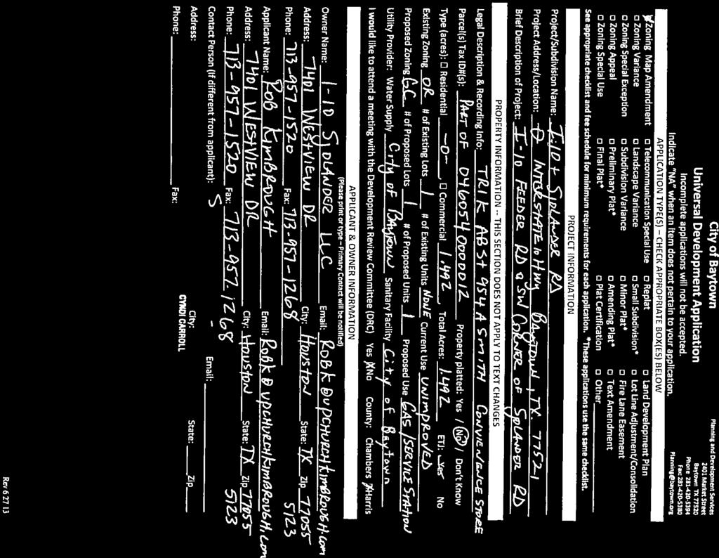
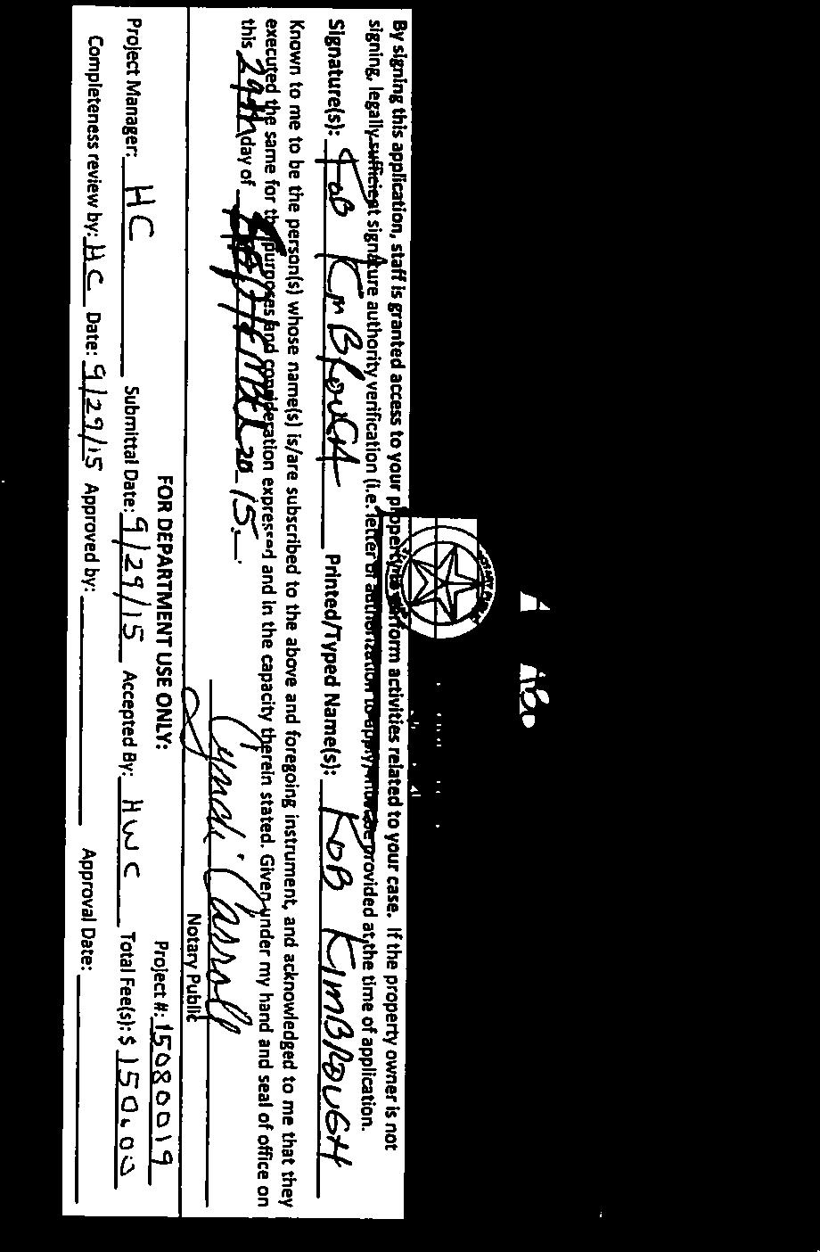
18 PLANNING AND ZONING COMMISSION 3. a. Meeting Date: 11/17/2015 Subject: Second Public Hearing - Zoning Map Amendment for approximately 1.5 acres from OR to GC. Prepared for: Tiffany Foster, Planning and Development Services Prepared by: Harold Cheek, Planning and Development Services Information ITEM Conduct the second public hearing concerning a proposed amendment to the official zoning map to rezone approximately 1.5 acres of area, generally located at the southwest corner of I-10 and Sjolander Road, legally described as being a portion of Tract 1K Abstract 954 of the Ashbel Smith Survey, Harris County, Texas, from Open Space/Recreation (OR) to General Commercial (GC). PREFACE This public hearing is concerning a property that is currently vacant and the applicant is proposing to develop the site as a convenience store and gas station. To develop the subject property as a convenience store and receive city utilities, the parcel must be annexed and rezoned to General Commercial (GC). The annexation petition has also been submitted and is being processed concurrently. This proposed location has many qualities conducive to a convenience store and gas station development. It is located at the intersection of two major thoroughfares for access at I-10 and Sjolander. Both roads are heavily traveled and there is a mix of nearby residential and commercial land uses. The first public hearing was held on October 20, 2015, before the Planning and Zoning Commission. The annexation and rezoning will conclude at the January 14, 2016 City Council meeting. The application, supporting documentation, and staff report are attached for your review. RECOMMENDATION This is the second public hearing. Application and Supporting Documents Attachments 15
19 Vicinity Map Notice Area Map Site Plan Staff Report 16

20 17

21 18

22 19


23 20

24 21


25 µ Zoning Amendment Exhibit A Zoning Change of approximately 1.49 Acres Southwest corner of I-10 and Sjolander From OR to GC Subject Property Harris Parcels 2015 IH 10 SH 330 SH 146 SH 146 Document Path: M:\Maps_By_Baytown\Planning Staff\I-10_Main_to_Sjloander_Annexation_ \I-10_Main_and_Sjloander_Zoning_8-5x11L_ mxd The City of Baytown Texas makes no warranty, representation, or guarantee regarding the accuracy of this map. This map is intended for display purposes only and does not replace official recorded documents. 1 inch = feet Date

 GC (General Commercial) HI (Heavy Industrial) LC (Livable Center) LI (Light Industrial) MF1")
 MU (Mixed Use) NSC (Neighborhood Serving Commercial) OR (Open Space/Recreation) SF1 (Low Density")
 UN (Urban Neighborhood) IH 10 SH 330 SH 146 SH 146 Document Path: M:\Maps_By_Baytown\Planning")

26 GC µ Zoning Amendment Exhibit A Zoning Change of approximately 1.49 Acres Southwest corner of I-10 and Sjolander From OR to GC LI GC SF1 Subject Property 300' Property Selection Zone Properties to be Notified Harris Parcels 2015 Zoning Districts ACE (Arts, Cultural and Entertainment) GC (General Commercial) HI (Heavy Industrial) LC (Livable Center) LI (Light Industrial) MF1 (Med. Density Mixed Res.) MF2 (Mid-Rise Mixed Res.) MF3 (High Density Mixed Res.) MU (Mixed Use) NSC (Neighborhood Serving Commercial) OR (Open Space/Recreation) SF1 (Low Density Single-Fam. Res.) SF2 (Mixed Res. Low/Med. Density) SFE (Single-Fam. Estate) UN (Urban Neighborhood) IH 10 SH 330 SH 146 SH 146 Document Path: M:\Maps_By_Baytown\Planning Staff\I-10_Main_to_Sjloander_Annexation_ \I-10_Main_and_Sjloander_Zoning_8-5x11L_ mxd The City of Baytown Texas makes no warranty, representation, or guarantee regarding the accuracy of this map. This map is intended for display purposes only and does not replace official recorded documents. 1 inch = feet Date
27 z j;1 ::0 "' ~ iii ~ 0 "' c z 0 ill m 0 m ;o ~ ~ :\_ / / =:;;;:_ 0} ;;'~- I ~ I I I I ' ~- I I : I I I F I I I I I I I I I --.. it- :\-1- i I 4f-..,._, ~~~ Ill ' I I - 7 : -' I I ~ / ~ / ~L j ~ r E~ ~~ ] ls - - :-,_ u ~! l -. -! - / ~ 0 j i ~~! ~ i5 z """, ,_, - ' - +,!I :: STORE NAME CONVENIENCE STORE J.IO SJOI.ANDER I!A Yl'OWN, TX 24
28 Staff Report I-10 and Sjolander Road Zoning Map Amendment Requested Action: Zoning Map Amendment request to change the zoning designation from Open Space/Recreational (OR) to General Commercial (GC). Applicant: Rob Kimbrough Subject Property: Is approximately 1.5 acres, located at the southwest corner of I-10 and Sjolander Road and legally described as a portion of Tract 1K out of the Ashbel Smith Survey, abstract 954, Harris County, Texas. Parcel Information Current Use: Vacant land Proposed Use: Convenience Store Future Land Use Plan: Business Park Adjacent Parcel Information North: I-10 South: Vacant, (ETJ) East: Sjolander Road West: Vacant, (ETJ) Staff Analysis (Background): This property is currently outside the City limits and vacant. The applicant is proposing to develop a convenience store and gas station. To develop the subject property as a convenience store and receive city utilities, the property would have to be annexed and rezoned (GC). The applicant has submitted an annexation petition which is being processed concurrently. This location has many qualities conducive to a convenience store and gas station development like being located at the intersection of two major thoroughfares for access and having a mix of nearby commercial and residential land uses. In order to recommend approval of an application for a zoning amendment, the Planning and Zoning Commission shall consider the following factors: 1. Consistency with guiding documents. The request is consistent with the Baytown 2025 Comprehensive Plan Future Land Use Plan (FLUP) as the subject property is designated as Business Park and a convenience store being a retail use is appropriate according to the FLUP Land Use Narratives (shown below). One of the FLUP criteria for a Business Park is a development that has adequate access to freeways, major arterials, rail, and/or navigable waterways and is of variable depths along or near major arterials and freeways. Sjolander Road is a major arterial and I-10 is a freeway on the Baytown Major Thoroughfare Plan providing ample access to and from the subject property. 25
29 Business Park (Purple) Accommodates business activities in planned campus-like settings with interdependent and complementary uses. Preferred uses and forms include office buildings of various heights, research and development facilities, light manufacturing, high-tech industries, warehousing, and distribution. Includes a mix of light industrial and retail uses, along with indoor and outdoor commercial activities. Development should have adequate access to freeways, major arterials, rail, and/or navigable waterways and be of variable depths along or near major arterials and freeways. Excludes heavy industrial uses. 2. Compatible with the Surrounding Area. The surrounding area, to the west and south, are currently vacant and outside the city limits. Being located adjacent to I-10 and Sjolander Road, and near established residential and commercial facilities means that the area is ripe for development and a convenience store would be a compatible use. Single family residences are located to the east of Sjolander Road, commercial to the west along I-10, and industrial on the north side of I-10. The adjacent properties to the south and west are vacant and currently outside the City limits. It is unlikely that the proposed development would adversely affect adjacent properties that are undeveloped. 3. Promotion of health, safety, or general welfare. The proposed use promotes orderly development as it recognizes that the subject tract is a prime location for general commercial development. Future development on this property would need to meet the ULDC zoning requirements, as well as, all other building codes to promote health, safety, and general welfare. 4. Facilitation of infrastructure. The needed infrastructure will be constructed with the development; however, water and sewer utilities are adjacent to the property. 5. There are changed conditions. With the economic upturn in Baytown, a lot of new development is being proposed. Parcels and sites which have been vacant and undeveloped in the past are being considered for development. The property is currently being annexed into the City for commercial development, and owner is looking to develop into a commercial venture. 6. Effect on natural environment. This zone change will permit greenfield development but has limited impact on the natural environment other than the impervious coverage and loss of habitat. 26
30 7. Community need. Continued greenfield development and growth of the City is good for the tax base. This development will provide for some commercial retail and passenger vehicle fueling needs to the I-10 and Sjolander Road area. Public Notification: Public notification was posted at the city website and City Hall on October 2, 2015, posted in the Baytown Sun on October 4, 2015, and mailed to surrounding properties on October 6,
31 PLANNING AND ZONING COMMISSION 3. b. Meeting Date: 11/17/2015 Subject: Consider - Zoning Map Amendment for approximately 1.5 acres from OR to GC. Prepared for: Tiffany Foster, Planning and Development Services Prepared by: Harold Cheek, Planning and Development Services Information ITEM Consider making a recommendation and preparing a report concerning a proposed amendment to the official zoning map to rezone approximately 1.5 acres of area, generally located at the southwest corner of I-10 and Sjolander Road, legally described as being a portion of Tract 1K Abstract 954 of the Ashbel Smith Survey, Harris County, Texas, from Open Space/Recreation (OR) to General Commercial (GC). PREFACE This consideration item is concerning a property that is currently vacant and the applicant is proposing to develop the site as a convenience store and gas station. To develop the subject property as a convenience store and receive city utilities, the parcel must be annexed and rezoned to General Commercial (GC). The annexation petition has also been submitted and is being processed concurrently. This proposed location has many qualities conducive to a convenience store and gas station development. It is located at the intersection of two major thoroughfares for access at I-10 and Sjolander. Both roads are heavily traveled and there is a mix of nearby residential and commercial land uses. The first public hearing was held on October 20, 2015, before the Planning and Zoning Commission. The annexation and rezoning will conclude at the January 14, 2016 City Council meeting. The application, supporting documentation, and staff report are attached to the previous agenda item for your review. The Planning and Zoning Commission's report to City Council is attached for your consideration. RECOMMENDATION 28
32 P&Z Report to City Council Attachments 29
33 PLANNING AND ZONING REPORT TO COUNCIL TO: City Council FROM: Planning and Zoning Commission RE: Zoning Map Amendment from Open Space/Recreational (OR) to General Commercial (GC). DATE: November 17, 2015 This is the report required to be submitted by the Planning and Zoning Commission per Section 1.26 of the Unified Land Development Code, Baytown Code of Ordinances to the City Council. This report also serves as the final report that is to be used by the Council in its consideration of the amendment as set forth in Section 1.26 of the code. Requested Action: Zoning Map Amendment request to change the zoning designation from Open Space/Recreational (OR) to General Commercial (GC). Applicant: Rob Kimbrough Subject Property: Is approximately 1.5 acres, located at the southwest corner of I-10 and Sjolander Road and legally described as a portion of Tract 1K out of the Ashbel Smith Survey, abstract 954, Harris County, Texas. Parcel Information Current Use: Vacant land Proposed Use: Convenience Store Future Land Use Plan: Business Park Adjacent Parcel Information North: I-10 South: Vacant, (ETJ) East: Sjolander Road West: Vacant, (ETJ) Staff Analysis (Background): This property is currently outside the City limits and vacant. The applicant is proposing to develop a convenience store and gas station. To develop the subject property as a convenience store and receive city utilities, the property would have to be annexed and rezoned (GC). The applicant has submitted an annexation petition which is being processed concurrently. This location has many qualities conducive to a convenience store and gas station development like being located at the intersection of two major thoroughfares for access and having a mix of nearby commercial and residential land uses. 30
34 In order to recommend approval of an application for a zoning amendment, the Planning and Zoning Commission shall consider the following factors: 1. Consistency with guiding documents. The request is consistent with the Baytown 2025 Comprehensive Plan Future Land Use Plan (FLUP) as the subject property is designated as Business Park and a convenience store being a retail use is appropriate according to the FLUP Land Use Narratives (shown below). One of the FLUP criteria for a Business Park is a development that has adequate access to freeways, major arterials, rail, and/or navigable waterways and is of variable depths along or near major arterials and freeways. Sjolander Road is a major arterial and I-10 is a freeway on the Baytown Major Thoroughfare Plan providing ample access to and from the subject property. Business Park (Purple) Accommodates business activities in planned campus-like settings with interdependent and complementary uses. Preferred uses and forms include office buildings of various heights, research and development facilities, light manufacturing, high-tech industries, warehousing, and distribution. Includes a mix of light industrial and retail uses, along with indoor and outdoor commercial activities. Development should have adequate access to freeways, major arterials, rail, and/or navigable waterways and be of variable depths along or near major arterials and freeways. Excludes heavy industrial uses. 2. Compatible with the Surrounding Area. The surrounding area, to the west and south, are currently vacant and outside the city limits. Being located adjacent to I-10 and Sjolander Road, and near established residential and commercial facilities means that the area is ripe for development and a convenience store would be a compatible use. Single family residences are located to the east of Sjolander Road, commercial to the west along I-10, and industrial on the north side of I- 10. The adjacent properties to the south and west are vacant and currently outside the City limits. It is unlikely that the proposed development would adversely affect adjacent properties that are undeveloped. 3. Promotion of health, safety, or general welfare. The proposed use promotes orderly development as it recognizes that the subject tract is a prime location for general commercial development. Future development on this property would need to meet the ULDC zoning requirements, as well as, all other building codes to promote health, safety, and general welfare. 4. Facilitation of infrastructure. 31
35 The needed infrastructure will be constructed with the development; however, water and sewer utilities are adjacent to the property. 5. There are changed conditions. With the economic upturn in Baytown, a lot of new development is being proposed. Parcels and sites which have been vacant and undeveloped in the past are being considered for development. The property is currently being annexed into the City for commercial development, and owner is looking to develop into a commercial venture. 6. Effect on natural environment. This zone change will permit greenfield development but has limited impact on the natural environment other than the impervious coverage and loss of habitat. 7. Community need. Continued greenfield development and growth of the City is good for the tax base. This development will provide for some commercial retail and passenger vehicle fueling needs to the I-10 and Sjolander Road area. Public Notification: Public notification was posted at the city website and City Hall on October 2, 2015, posted in the Baytown Sun on October 4, 2015, and mailed to surrounding properties on October 6, The Commission recommends approval disapproval of the proposed zoning map amendment from OR to GC. Passed, Failed by vote of the Planning and Zoning Commission of the City of Baytown the 17 th of November, Spencer Carnes, Chairman City of Baytown, Texas Planning and Zoning Commission 32
36 PLANNING AND ZONING COMMISSION 3. c. Meeting Date: 11/17/2015 Subject: Second Public Hearing - Zoning Map Amendment for approximately 3.62 acres from OR to GC Prepared for: Tiffany Foster, Planning and Development Services Prepared by: Nathan Dietrich, Planning and Development Services Information ITEM Conduct the second public hearing concerning a proposed amendment to the official zoning map to rezone approximately 3.62 acres of land, save and except land previously annexed by Ordinance No. 1365, located at the intersection of N. Main Street along the north right-of-way of Blue Heron Parkway, part of and out of J. W. Singleton Survey, Abstract No. 709, Harris County, Texas, from Open Space/Recreation (OR) to General Commercial (GC). PREFACE This public hearing is concerning a property that is currently vacant and the applicant is proposing to develop it commercially. A small portion of this property, approximately 0.40 acres (the save and except portion in the legal description), on the northeast corner of the intersection is currently in the City limits and zoned GC. The remainder of the property is outside the City limits. To develop the subject property commercially and receive City utilities, the remaining portion of the parcel would have to be annexed and rezoned to GC. An annexation petition has also been submitted and is being processed concurrently. This proposed location has many qualities conducive to commercial development like being located at the intersection of two major thoroughfares for access; North Main Street and Blue Heron Parkway both arterials, and having a mix of nearby residential and commercial land uses. The first public hearing was heard at the Planning and Zoning meeting on October 20, The annexation and rezoning will conclude together at the December 10, 2015 City Council meeting. The application, supporting documentation, and staff report are attached for your review. RECOMMENDATION This is the second public hearing. 33
37 Application and Supporting Documents Vicinty Map Notice Area Map Staff Report Attachments 34


38 35

39 36

40 37


41 38

42 39

43 40


44 41

45 42

46 43

47 44


48 45


49 46

50 47

51 48

52 49


 MF1 (Med. Density Mixed Res.) MF2 (Mid-Rise Mixed Res.) W BAKER RD CINNAMON ST THYME CIR MF3 (High Density Mixed Res.")
 SF2 (Mixed Res. Low/Med. Density) SFE (Single-Fam.")

53 MF2 NORTHRIDGE DR BARKULOO RD µ µ Zoning Amendment CRAIG ST Blue Heron and N. Main Exhibit A BELVIEW ST DENT DR SHEARER LN GC From OR to GC BLUE HERON PARKWAY CURRY ST SF2 OLEANDER ST ALMOND ST Approximately 3.62 Acres at Blue Heron and N. Main, save and except previously annexed land by Ordinance No. 1365, From OR to GC Subject Property 300' Property Selection Zone Properties to be Notified Subject Property Harris Parcels 2015 Subject Property Zoning Districts ACE (Arts, Cultural and Entertainment) GC (General Commercial) HI (Heavy Industrial) LC (Livable Center) LI (Light Industrial) MF1 (Med. Density Mixed Res.) MF2 (Mid-Rise Mixed Res.) W BAKER RD CINNAMON ST THYME CIR MF3 (High Density Mixed Res.) MU (Mixed Use) NSC (Neighborhood Serving Commercial) OR (Open Space/Recreation) SF2 SAGE ST SF1 (Low Density Single-Fam. Res.) SF2 (Mixed Res. Low/Med. Density) SFE (Single-Fam. Estate) UN (Urban Neighborhood) GC N MAIN ST CHAD LN SH 330 IH 10 SH 146 JEAN LN SH 146 GC CHARLES PL CHRISTOPHER LN HARTMAN DR The City of Baytown Texas makes no warranty, representation, or guarantee regarding the accuracy of this map. This map is intended for display purposes only and does not replace official recorded documents. Document Path: M:\Maps_By_Baytown\Planning Staff\Blue_Heron_and_N_Main\ZONE_CHANGE\Blue_Heron_Zoning_8-5x11L_ mxd 1 inch = feet Date
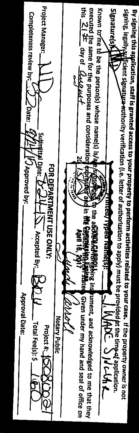
54 Staff Report North Main Street and Blue Heron Parkway Zoning Map Amendment Requested Action: Zoning Map Amendment request to change the zoning designation from Open Space/Recreational (OR) to General Commercial (GC). Applicant: Wade Sinclair Subject Property: Is approximately 3.62 acres of land, save and except previously annexed land by Ordinance No. 1365, located at the intersection of N. Main Street along the north right-of-way of Blue Heron Parkway, part of and out of J. W. Singleton Survey, Abstract No. 709, Harris County, Texas. Parcel Information Current Use: Vacant land Proposed Use: Commercial Future Land Use Plan: Commercial Corridor and Low-Medium Density Residential Adjacent Parcel Information North: Commercial uses, General Commercial zoning designation South: Blue Heron Parkway, ETJ East: Public infrastructure (Man-made drainage ditch and Blue Heron Parkway), ETJ West: North Main Street Staff Analysis (Background): This property is currently outside the City limits and vacant. A small portion of this property, approximately 0.40 acres (the save and except portion in the legal description) on the northeast corner of the intersection is currently in the City limits and zoned GC. The applicant is proposing to develop the subject property commercially. To develop the subject property commercially and receive city utilities, the remaining portion of the parcel would have to be annexed and rezoned (GC). The applicant has submitted a petition for annexation and this application is being processed concurrently. The proposed location has many qualities conducive to commercial development like being located at the intersection of two major thoroughfares for access; North Main Street and Blue Heron Parkway both arterials, and having a mix of nearby land uses of commercial and residential. In order to recommend approval of an application for a zoning amendment, the Planning and Zoning Commission shall consider the following factors: 1. Consistency with guiding documents. The request is consistent with the Baytown 2025 Comprehensive Plan Future Land Use Plan (FLUP) as the subject property is designated as Commercial Corridor and Low- Medium Density Residential. As described in the Land Use Narratives below General Commercial (GC) zoning is conducive with the applicant s request and many types of commercial development that could be accommodated by the subject property. 51
55 Commercial Corridors (Red) May accommodate all types of commercial activity, including big box, medical services, restaurants, entertainment, offices, and large multi-family development. Corridors of commercial activities with variable depths along or near major arterials and freeways. Low-Medium Density Residential (Peach) Uses including places of assembly, schools, parks, and other community facilities such as libraries with pedestrian links to residential. Commercial that serves neighborhoods not regions, such as office buildings, and neighborhood services to support and compliment residential area. Small-scale, neighborhood commercial located within a convenient walking distance of residences and buffered when adjacent to a residential use. Appropriate area for pedestrian and bicycle-friendly streets. Medium density development along perimeter of neighborhoods and generally along collector streets. 2. Compatible with the Surrounding Area. The surrounding areas, to the south and east, are currently vacant and outside the city limits. The proposed rezoning of the subject property to GC would be compatible with the surrounding properties to the north and west because they are commercial uses with GC zoning designations. North and west of the subject property are compatible since they are zoned GC and have existing commercial uses. 3. Promotion of health, safety, or general welfare. The proposed zoning change promotes orderly development as the subject tract is a prime location for general commercial development. Future development on this property would need to meet the Unified Land Development Code zoning requirements, as well as, all other building codes to promote health, safety, and general welfare. 4. Facilitation of infrastructure. If infrastructure is required it will be constructed with the development. The water and waste water lines are located along North Main Street; west side and east side respectively. There are storm sewer lines on North Main Street and along Blue Heron Parkway (southeast side). 5. There are changed conditions. With the economic upturn in Baytown, a lot of new development is being proposed. Parcels and sites which have been vacant and undeveloped in the past are being considered for development. The Baker Road Extension project: Blue Heron Parkway is a new and viable east/west collector that will provide more east/west connectivity and facilitate more development. Regarding to the subject property, a petition for voluntary annexation has been requested and is running concurrently with the rezoning request. 52
56 6. Effect on natural environment. This zone change will permit greenfield development but has limited impact on the natural environment other than the impervious coverage and loss of habitat. 7. Community need. Continued economic development and growth of the City is good for the tax base. Additionally, development of vacant land near existing services and other established businesses helps build the local economy without stressing existing infrastructure. Public Notification: Posted at the City website and City Hall on October 2, 2015, posted in the Baytown Sun on October 4, 2015, and mailed to surrounding properties on October 6,
57 PLANNING AND ZONING COMMISSION 3. d. Meeting Date: 11/17/2015 Subject: Consider - Zoning Map Amendment for approximately 3.62 acres from OR to GC. Prepared for: Tiffany Foster, Planning and Development Services Prepared by: Shelly Shelton, Planning and Development Services Information ITEM Consider making a recommendation and preparing a report concerning a proposed amendment to the official zoning map to rezone approximately 3.62 acres of land, save and except land previously annexed by Ordinance No. 1365, located at the intersection of N. Main Street along the north right-of-way of Blue Heron Parkway, part of and out of J. W. Singleton Survey, Abstract No. 709, Harris County, Texas, from Open Space/Recreation (OR) to General Commercial (GC). PREFACE This consideration item is is concerning a property that is currently vacant and the applicant is proposing to develop it commercially. A small portion of this property, approximately 0.40 acres (the save and except portion in the legal description), on the northeast corner of the intersection is currently in the City limits and zoned GC. The remainder of the property is outside the City limits. To develop the subject property commercially and receive City utilities, the remaining portion of the parcel would have to be annexed and rezoned to GC. The annexation petition has also been submitted and is being processed concurrently. This proposed location has many qualities conducive to commercial development like being located at the intersection of two major thoroughfares for access; Main Street and Blue Heron Parkway both arterials, and having a mix of nearby residential and commercial land uses. The first public hearing was heard at the Planning and Zoning meeting on October 20, The annexation and rezoning will conclude together at the December 10, 2015 City Council meeting. The application, supporting documentation and staff report are attached under the previous public hearing for your review. The Planning and Zoning Commission's Report to City Council is attached for your consideration. RECOMMENDATION 54
58 P&Z Report to City Council Attachments 55
59 PLANNING AND ZONING REPORT TO CITY COUNCIL TO: City Council FROM: Planning and Zoning Commission RE: Zoning Map Amendment from OR to GC DATE: November 17, 2015 This is the report required to be submitted by the Planning and Zoning Commission per Section 1.26 of the Unified Land Development Code, Baytown Code of Ordinances to the City Council. This report also serves as the final report that is to be used by the Council in its consideration of the amendment as set forth in Section 1.26 of the code. Requested Action: Zoning Map Amendment request to change the zoning designation from Open Space/Recreational (OR) to General Commercial (GC). Applicant: Wade Sinclair Subject Property: Is approximately 3.62 acres of land, save and except previously annexed land by Ordinance No. 1365, located at the intersection of N. Main Street along the north right-of-way of Blue Heron Parkway, part of and out of J. W. Singleton Survey, Abstract No. 709, Harris County, Texas. Parcel Information Current Use: Vacant land Proposed Use: Commercial Future Land Use Plan: Commercial Corridor and Low-Medium Density Residential Adjacent Parcel Information North: Commercial uses, General Commercial zoning designation South: Blue Heron Parkway, ETJ East: Public infrastructure (Man-made drainage ditch and Blue Heron Parkway), ETJ West: North Main Street Staff Analysis (Background): This property is currently outside the City limits and vacant. A small portion of this property, approximately 0.40 acres (the save and except portion in the legal description) on the northeast corner of the intersection is currently in the City limits and zoned GC. The applicant is proposing to develop the subject property commercially. To develop the subject property commercially and receive city utilities, the remaining portion of the parcel would have to be annexed and rezoned (GC). The applicant has submitted a petition for annexation and this application is being processed concurrently. The proposed location has many qualities conducive to commercial development like being located at the intersection of two major thoroughfares for access; North Main Street and Blue Heron Parkway both arterials, and having a mix of nearby land uses of commercial and residential. In order to recommend approval of an application for a zoning amendment, the Planning and Zoning Commission shall consider the following factors: 56
60 1. Consistency with guiding documents. The request is consistent with the Baytown 2025 Comprehensive Plan Future Land Use Plan (FLUP) as the subject property is designated as Commercial Corridor and Low-Medium Density Residential. As described in the Land Use Narratives below General Commercial (GC) zoning is conducive with the applicant s request and many types of commercial development that could be accommodated by the subject property. Commercial Corridors (Red) May accommodate all types of commercial activity, including big box, medical services, restaurants, entertainment, offices, and large multi-family development. Corridors of commercial activities with variable depths along or near major arterials and freeways. Low-Medium Density Residential (Peach) Uses including places of assembly, schools, parks, and other community facilities such as libraries with pedestrian links to residential. Commercial that serves neighborhoods not regions, such as office buildings, and neighborhood services to support and compliment residential area. Small-scale, neighborhood commercial located within a convenient walking distance of residences and buffered when adjacent to a residential use. Appropriate area for pedestrian and bicycle-friendly streets. Medium density development along perimeter of neighborhoods and generally along collector streets. 2. Compatible with the Surrounding Area. The surrounding areas, to the south and east, are currently vacant and outside the city limits. The proposed rezoning of the subject property to GC would be compatible with the surrounding properties to the north and west because they are commercial uses with GC zoning designations. North and west of the subject property are compatible since they are zoned GC and have existing commercial uses. 3. Promotion of health, safety, or general welfare. The proposed zoning change promotes orderly development as the subject tract is a prime location for general commercial development. Future development on this property would need to meet the Unified Land Development Code zoning requirements, as well as, all other building codes to promote health, safety, and general welfare. 4. Facilitation of infrastructure. If infrastructure is required it will be constructed with the development. The water and waste water lines are located along North Main Street; west side and east side respectively. There are storm sewer lines on North Main Street and along Blue Heron Parkway (southeast side). 5. There are changed conditions. With the economic upturn in Baytown, a lot of new development is being proposed. Parcels and sites which have been vacant and undeveloped in the past are being considered for development. The Baker Road Extension project: Blue Heron Parkway is a new and viable east/west collector that will provide more east/west connectivity and facilitate more development. Regarding to the subject property, a petition for voluntary annexation has been requested and is running concurrently with the rezoning request. 57
61 6. Effect on natural environment. This zone change will permit greenfield development but has limited impact on the natural environment other than the impervious coverage and loss of habitat. 7. Community need. Continued economic development and growth of the City is good for the tax base. Additionally, development of vacant land near existing services and other established businesses helps build the local economy without stressing existing infrastructure. Public Notification: Posted at the City website and City Hall on October 2, 2015, posted in the Baytown Sun on October 4, 2015, and mailed to surrounding properties on October 6, The Commission recommends approval disapproval of the proposed zoning map amendment from OR to GC. Passed, Failed by vote of the Planning and Zoning Commission of the City of Baytown the 17th day of November, Spencer Carnes, Chairman City of Baytown, Texas Planning and Zoning Commission 58
62 PLANNING AND ZONING COMMISSION 3. e. Meeting Date: 11/17/2015 Subject: Second Public Hearing: ULDC text change to add heavier uses in GC Prepared for: Tiffany Foster, Planning and Development Services Prepared by: Nathan Dietrich, Planning and Development Services Information ITEM Conduct the second public hearing concerning amending the text of the Unified Land Development Code (ULDC) to provide for additional heavier commercial uses in the General Commercial (GC) zoning district, to develop definitions and compatibly standards related thereto, and to clarify and consolidate terms, uses and conditions for all zoning districts to better differentiate between adjacent uses and districts. PREFACE This public hearing is concerning proposed amendments to the text of the Unified Land Development Code (ULDC). With recent expansion of the local economy, staff has received many requests for uses or expansions that could be included in General Commercial with the adoption of appropriate conditions. These proposed changes expand the uses and widen allowances for heavier commercial uses within GC, while providing stronger conditions to limit the impact of these uses to nearby residents and neighboring businesses. In addition to the proposed expanded uses and conditions above, the application also includes clarifying changes to the text and terms in order to better integrate into the ULDC as a whole. On November 10, 2015, the Planning and Zoning Commission held a special meeting in order to discuss and comment on the text changes that were being proposed. Additional comments and clarification were discussed and the revised version will be included with this agenda item. The application statement, supporting documents, and staff report, are attached for your review. RECOMMENDATION This is the second public hearing. Application Staff Report Amendments Attachments 59
63 60


64 61

65 62

66 63

67 64
68 Request to make Zoning Text Amendments Staff Report for Zoning Text Amendment These proposed Zoning Text Amendments are to amend the Unified Land Development Code (ULDC) to provide for additional heavier commercial uses in the General Commercial (GC) zoning district; to develop conditions, definitions, and compatibility standards related thereto; and to clarify and consolidate terms, uses and conditions for all zoning districts to better differentiate between uses and districts. Existing and Proposed Land Uses This is an application to amend text of the ULDC but does not specifically apply to any one parcel. Criteria for Rezoning Applications 1. Consistency with guiding documents. The proposed text amendments are in line with the City s guiding documents (City s Comprehensive Plan (Future Land Use Plan and Major Thoroughfare Plan). These amendments will have limited impact on the guiding documents since the proposed changes will have a more impact relating to property development and operational standards. 2. Compatible with the Surrounding Area. The proposed amendments provide changes to uses within the General Commercial zoning district mostly. One of the overall goals to this amendment is to ensure that harmony and compatibility is kept or improved by adding additional conditions within the land use table. 3. Promotion of health, safety, or general welfare. The proposed amendments will further define uses in the ULDC. Where these uses are more intense than what was previously allowed, the amendment adds use conditions to ensure the promotion of a healthy community. 4. Facilitation of infrastructure. There is no effect on the facilitation of infrastructure. 65
69 5. There are changed conditions. Baytown is historically an industrialized City. As the continued roll out of the plant expansions we in turn have received many requests for expansions to all of the ancillary and complementary businesses to the plants. What staff has noticed is a need to further define some of the uses and conditions for these districts allowing for further integration and blending to achieve a better mix of uses in the General Commercial District. 6. Effect on Natural Environment. The proposed text amendments have a limited effect on the natural environment. 7. Community need. The community will benefit from these changes by further defining land uses, conditions and their roles within the community. It is felt that these changes will help better facilitate planning and development and the allowed uses throughout the community while better integrating heavier commercial uses in commercial districts. 66
70 Proposed ULDC Text Amendments for General Commercial November 17, 2015 Draft Article II. Use Districts, Division 2. Zoning Districts, Sec Commercial zoning districts (d) (f) General commercial ("GC"). This district is intended to provide for a variety of uses including offices, retail, personal and commercial services, and related uses that are mixed within buildings either vertically and/or horizontally. Uses in this district are generally conducted wholly within an enclosed building but may include outdoor display merchandise or storage of materials. The GC district may be used as a transitional district between more intensive nonresidential districts (e.g., industrial) and higher density residential districts or as the primary district for such corridors as Garth Road or Main Street. Light industrial ("LI"). This district is intended to provide for low-intensity industrial and manufacturing activities that may generate some nuisances. Uses in this district are not appropriate adjacent to any residential use or residential district unless separated by an arterial or collector street and/or setbacks and screening. Article II. Use Districts, Division 2. Zoning Districts, Sec Land Use Tables This section sets forth the land uses allowed in each zoning district. In the following tables "P" means permitted use and "PC" means permitted use with conditions as set forth in the conditions tables in division 3 of this article. Where neither a "P" nor a "PC" exists in the table, the use is prohibited. To the extent that there is a conflict between the use tables and the conditions, the use table controls. The conditions expressed in the use table are cumulative of applicable conditions contained elsewhere in the code. USES Table 2-2. Non-residential uses. MU NSC ACE GC LC LI HI COND REF Agriculture PC PC PC PC PC A4 Animals PC PC PC A5, A25 Vehicle repair, commercial PC PC A1 Vehicle repair, non-commercial PC PC P A2 Boat and RV storage PC PC P A36, A52 Building, heating, plumbing, general, service or electrical contractors with outdoor storage... PC PC P A3 1 67
71 USES MU NSC ACE GC LC LI HI COND REF Dwelling unit PC PC PC PC A44, A47 Gas stations P PC P PC PC A15, A16, A47 Manufacturing (light) PC PC PC P A48 Nursing homes and assisted living facilities PC PC PC A20, A22, A47 Outdoor sales and display PC PC PC PC PC P P A 47, A50 Recreational vehicle park PC PC PC A31 Repair business PC PC PC PC PC P A47, A55 Retail, General P PC P P PC P A18, A47 Retail, Big box PC PC A17 Supply houses PC PC PC P A54 Truck stop PC P P A46 Towing Service PC P A36, A38 Vehicle Storage PC P A36, A38 Warehouse and freight movement PC PC P P A40... Wholesale trade PC PC P A
72 ... Table 2-3. Non-residential accessory use table. ACCESSORY USE MU NSC ACE GC LC LI HI COND REF Sandblasting PC PC PC PC PC PC PC A56, A
73 Sec Land use conditions. This section sets forth the conditions associated with identified land uses in section No. Land Use Applicable Zoning District A. Non-residential categories Conditions 1 Vehicle repair, commercial LI, HI (a) (b) Vehicles must be kept on the private property of the vehicle repair facility. Vehicle storage is subject to the outdoor storage conditions of this ordinance and must be kept behind opaque screening and in accordance with chapter 112 of the Code of Ordinances. (a) Vehicle repair shall be separated from all adjacent uses by opaque screening. 2 Vehicle repair, noncommercial GC, MU (b) (c) Vehicles must be kept on the private property of the automobile repair. Vehicle storage is subject to the outdoor storage conditions of this ordinance and must be kept behind opaque screening and in accordance with chapter 112 of the Code of Ordinances. 3 Building, heating, plumbing, general, service or electrical contractors with outdoor storage GC, MU (a) Outdoor storage shall be separated from all adjacent uses and public rights-of-way by opaque screening. 4 Agriculture All, where permitted Agricultural uses involving animal, livestock, exotic, or similar animal uses are regulated pursuant to chapter 14 and/or chapter 42, article V of the Code of Ordinances. 5 Animals All, where permitted Animals are regulated pursuant to chapter 14 and/or chapter 42, article V of the Code of Ordinances. 4 70
74 Food Service establishments All, where permitted Mobile Food Establishments are subject to the restrictions under chapter 42 of the Code of Ordinances Gas station NSC 16 Gas station... All, where permitted 25 Kennels GC, MU, LI Vehicle Storage MU 38 Towing service MU (a) Gas station shall not exceed 5,000 square feet in building size. (b) Gas station shall not have a drive through for food service in NSC. (c) Gas station is allowed only if located on (i) an arterial street, (ii) a collector street, or (iii) a local street intersecting a street of higher classification. Gas stations must provide opaque screening adjacent to any residential dwelling or property zoned for residential use. (a) Kennels are not allowed within 100 feet of any residential use. (b) Kennels are not allowed within 300 feet of a church, school, hospital, or place of assembly. (c) Kennels are not allowed within 300 feet from where food is sold or consumed. (d) Kennels shall not house exotic animals. (a) Stored vehicles shall be screened from all adjacent properties by opaque screening. (b) Vehicles that contain hazardous materials pursuant to the standards of the state department of transportation, the state commission on environmental quality, or any other regulatory agency of the state or federal government are not allowed to be in such vehicle storage. (a) Towing service shall install and maintain an opaque screen when adjacent to any other use and/or zoning district other than LI or HI. 5 71
75 (b) Towing service shall comply with all state laws and subject to the restrictions under chapter 102 of the Code of Ordinances. (a) Warehouse and freight movement excludes shipment or storage of hazardous cargo and/or materials. (b) Warehouse shall have a maximum building height of 40 feet. 40 Warehouse and freight movement, Wholesale Trade MU, GC (c) (d) (e) Outdoor storage shall be separated by opaque screening from all adjacent properties and all public rights-of-way. If warehouse exceeds 10,000 square feet, must adhere to LI vegetative buffer described in Sec of the Code of Ordinances. (f) No rail, boat, or air transport of cargo may be used for freight movement on site. (g) The primary activity must be done within the enclosed warehouse structure Outdoor storage, Container, 44 Dwelling Unit All, where permitted MU, ACE, LC, GC, LI, HI (h) Warehouse must be located on an arterial. All outdoor storage shall be separated by opaque screening from all adjacent properties and all public rights-of-way. (a) New dwelling units are allowed in MU where the residential lot provides an open space setback of 20 feet from any adjacent, existing nonresidential use. (b) New residential subdivisions proposed in MU shall only be approved where the subdivision is rezoned to an appropriate residential zoning district. (c) Dwelling units are allowed in ACE following the standards set forth in this ULDC. 6 72
76 Manufacturing (light) All, where permitted (d) Live-work uses may be located in an ACE district (e) (f) (g) (h) (a) i. Behind a business on its first floor as long as: ii. The exterior wall of the residential area is not along Texas Avenue; The exterior wall of the commercial use and the primary entrance to the commercial use is along Texas Avenue; and The commercial use occupies at least 25% of the area of the first floor; and Above the first floor where the residential unit has frontage on Texas Avenue. When a mixed-use building fronts on Texas Avenue in the ACE district, a residential use is allowed only i. If: ii. No residential dwelling unit on the first floor has a door opening onto the primary street; Less than 50% of the mixed-use building's frontage on the first floor along a primary street is used for residential dwelling unit(s); and The mixed-use building is not new construction; or If the residential unit is above the ground floor. Dwelling units are allowed in LC in cases in which they are allowed in the approved detailed plan. A dwelling unit is allowed in MU, GC, LI, and HI as an accessory use for on-site security and management purposes. Except as provided in condition A44(g), new dwelling units cannot be constructed after April 13, 2013, are not allowed in GC. All manufacturing activities must be contained entirely within a building. 7 73
77 49 Manufacturing (custom) Vehicle and boat sales, rental or leasing facility Equipment sales and rental facilities All, where permitted All, where permitted MU, GC 54 Supply houses MU, GC, LI 55 Repair Business All, where permitted (b) Manufacturing of hazardous cargo and/or materials is prohibited. (a) (b) (c) (a) (b) (c) (d) (a) (b) (a) (b) (c) (a) (b) All manufacturing (custom) activities are to be contained entirely within a building. Storage or manufacturing of hazardous cargo and/or materials is prohibited. All manufacturing (custom) activities shall be limited to 10,000 square feet of floor area or less. Repair work, if any, shall be done wholly inside of a building. Vehicles and boats sold, rented and leased may not have a gross vehicle weights greater than 13,000 pounds. Opaque screening is required in accordance with section of the Code of Ordinances. Vehicle storage areas must be designed and maintained in accordance with chapter 112 of the Code of Ordinances. All equipment shall be separated by opaque screening from all adjacent properties and all public rights-of-way, except one of each equipment type may be used for display purposes. The sale or rental of tools, tractors or equipment, which are over 13,000 lbs. GVWR and/ or are greater in height than 10 feet in its storage configuration and/or are designed and used solely for industrial purposes is not permitted. Outdoor storage shall be separated by opaque screening from all adjacent properties and all public rights-of-way. Storage or sales of hazardous cargo and/or materials is prohibited. Outdoor storage shall be separated by opaque screening from all adjacent properties and all public rights-of-way. Repair work shall be performed wholly inside of an enclosed structure. 8 74
78 56 Sandblasting MU, GC, NSC, ACE, LC 57 Sandblasting LI, HI Sandblasting must be conducted wholly within an enclosed structure. Sandblasting shall be permitted if (i) contained wholly inside of an enclosed structure or (ii) outside of an enclosed structure with an approved special use permit. Article III. Design and Compatibility Standards, DIVISION 5. - DISTRICT COMPATIBILITY STANDARDS Sec Compatibility standards. The following additional standards are applicable to property that is located at the boundary of two or more zoning districts. The following standards are also applicable to the portion of the LI or HI boundary that is within 300 feet of the referenced zoning district. The more intense new non-residential or multifamily use shall implement the applicable compatibility standards before a certificate of occupancy or completion will be issued. (a) (b) (c) (d) Medium density mixed residential (MF1). New development that is zoned MF1 and located adjacent to a property zoned, UN, SFE, SF1, or SF2 shall meet all requirements of the property development standards table in article three, division 1 of the ULDC and install a minimum of a six-foot-tall opaque screen between any property zoned OR,, UN, SFE, SF1 or SF2. Mid-rise density mixed residential dwellings (MF2). New development that is zoned MF2 and located adjacent to a property zoned, UN, SFE, SF1, SF2 or MF1 shall meet all requirements of the property development standards table in article three, division 1 of the ULDC, install a minimum of a six-foot-tall opaque screen, and provide a minimum of a 20-foot open space between any property zoned OR, UN, SFE, SF1, SF2 or MF1. Any building over 40 feet in height also shall comply with the residential proximity slope in subsection 3.12(c)(3) of the ULDC. High density residential dwelling units (MF3). New development that is zoned MF3 and located adjacent to a property zoned, UN, SFE, SF1, SF2, MF1, or MF2 shall meet all requirements of the property development standards table in article three, division 1 of the ULDC, install a minimum of a six-foot-tall opaque screen, and provide a minimum of a 20-foot open space between any property zoned OR, UN, SFE, SF1, SF2, MF1, or MF2. Any building over 40 feet in height also shall comply with the residential proximity slope in subsection 3.12(c)(3) of the ULDC. Neighborhood serving commercial (NSC). New development that is zoned NSC and located adjacent to a property zoned OR, UN, SFE, SF1, SF2, MF1 or MF2 shall meet all the requirements of the property development standards table in article three, division 1 of the ULDC and install a minimum of a six-foot-tall opaque screen between any property zoned OR, UN, SFE, SF1, SF2, MF1 or MF
79 (e) General commercial (GC). New development that is zoned GC and located adjacent to a property zoned OR, UN, SFE, SF1, SF2, or MF1 shall meet all the requirements of the property development standards table in article three division 1 of the ULDC, install a minimum of a six-foot-tall opaque screen and provide a minimum of a 20-foot open space between any property OR, UN, SFE, SF1, SF2, or MF1. Any building over 40 feet in height also shall comply with the residential proximity slope in subsection 3.12(c)(3) of the ULDC. New development that is zoned GC and located adjacent to a property zoned MF2 or MF3 shall meet all the requirements of the property development standards table in article three, division 1 of the ULDC and install a minimum of a six-foot-tall opaque screen between any property zoned MF2 or MF3. Any building over 40 feet in height also shall comply with the residential proximity slope in subsection 3.12(c)(3) of the ULDC. (f) (g) Mixed use (MU). MU that is located adjacent to a property zoned OR, UN, SFE, SF1, SF2, MF1, MF2, MF3 or NSC shall meet all the requirements of the property development standards table in article three, division 1 of the ULDC, install a minimum of a six-foot tall opaque screen and provide a minimum of a 20-foot open space between any property zoned OR, UN, SFE, SF1, SF2, MF1, MF2, MF3 or NSC. Any building over 40 feet in height also shall comply with the residential proximity slope in subsection 3.12(c)(3) of the ULDC. Light industrial (LI). New development that is zoned LI and located adjacent to (i) a property zoned OR, UN, SFE, SF1, SF2, ACE, LC, MF1, MF2, MF3, NSC; (ii) a lot that contains a single-family use; (iii) a public right-of-way designated as an arterial or collector on the city's adopted thoroughfare plan; or (iv) a navigable waterway shall meet all the requirements of the property development standards table in article three, division 1 of the ULDC and provide a minimum 200-foot building setback. New development that is zoned LI and located adjacent to a property zoned MU or GC shall meet all the requirements of the property development standards table in article three, division 1 of the ULDC and provide a minimum 100-foot building setback. Within the applicable setback, a 50-foot open space, a 50-foot vegetative buffer and an opaque screen shall be installed between any property zoned OR, UN, SFE, SF1, SF2, MF1, MF2, MF3, NSC, GC, or MU in accordance to section Any building over 40 feet in height also shall comply with the residential proximity slope in subsection 3.12(c)(3) of the ULDC. (h) Heavy industrial (HI). New development that is zoned HI and located (i) adjacent to a property zoned OR, NSC, MU or GC; (ii) adjacent to a public right-of-way designated as an arterial or collector on the city's adopted thoroughfare plan; or (iii) adjacent to a navigable waterway shall meet all the requirements of the property development standards table in article three, division 1 of the ULDC, and provide a minimum 300- foot building setback between (i) any property zoned OR, NSC or GC; (ii) a public 10 76
80 right-of-way designated as an arterial or collector on the city's adopted thoroughfare plan; or (iii) a navigable waterway. Within the setback a 100-foot vegetative buffer and a minimum of a six-foot-tall opaque screen shall be installed between any property that is (i) zoned OR, NSC or GC; (ii) a public right-of-way designated as an arterial or collector on the city's adopted thoroughfare plan; or (iii) a navigable waterway. Any building over 40 feet in height also shall comply with the residential proximity slope in subsection 3.12(c)(3) of the ULDC. HI zoned property is not permitted to be located adjacent to OR, UN, SFE, SF1, SF2, MU, ACE, LC, MF1, MF2 or MF3 zoned properties. Article IV. DEFINITIONS Agriculture refers to use of land that is actively used in the production of food or fiber, including the plowing, tillage, cropping, installing best management practices, seeding, cultivating, harvesting and storing food or fiber produced on site. This term also includes the raising of grazing animals, including but not limited to cattle, horses, sheep, goats or other exotic grazing animals, but excludes swine. This use does not include feedlots, animal hospital, kennel/boarding facility, pet store, livestock distribution, meat packing/processing operations and related uses such as abattoir, slaughterhouse, or rendering plant, stockyard or similar confined animal feeding and holding operations. Animals include all nonhuman members of the animal kingdom including domestic, exotic, and livestock. This term also includes pet/companion animal operations such as Animal Hospital, Kennel/Boarding facility, or Pet Store and/or live outdoor exhibitions. Equipment sales and rental facility means an establishment that is engaged in the sale or rental of tools, tractors, construction equipment, farm equipment, other similar equipment. This includes the servicing of such equipment. Gas station means a site used for the retail sale of automobile fuels, oils, travel aids, food items, and general merchandise. Masonry materials means and includes that form of construction defined below and composed of clay brick, natural stone, decorative concrete block, stucco, glass block, tilt-wall, rock, synthetic stucco material meeting applicable windspeed requirements, exterior insulation and finish systems (EIFS) complying with ASTM-E 330 structural testing and ASTM-C 1093 fastening, or other materials of equal characteristics laid up unit by unit set in mortar. The following materials shall not qualify nor be defined as "masonry materials" in meeting the minimum requirements for exterior construction of buildings, unless specifically approved by variance: exterior plaster or mortar wash surface material;, acrylic matrix, synthetic plaster, or other similar synthetic material; cementitious fiber board siding (such as "Hardy Plank" or "Hardy Board")
81 Vehicle, commercial means a motor vehicle or combination of motor vehicles used to transport passengers or property that: (1) has a gross combination weight rating of 26,001 or more pounds including a towed unit with a gross vehicle weight rating of more than 10,000 pounds; (2) has a gross vehicle weight rating of 26,001 or more pounds; or (3) is transporting hazardous materials and is required to be placarded under 49 C.F.R. Part 172, Subpart F. Vehicle, non -commercial means a motor vehicle, including a motorcycle, or other device in or by which a person or property is or may be transported or drawn on a public highway, but is otherwise not considered a commercial vehicle, farm vehicle, farm equipment, or farm implement
82 PLANNING AND ZONING COMMISSION 3. f. Meeting Date: 11/17/2015 Subject: Consider: ULDC text change to add heavier uses in GC Prepared for: Tiffany Foster, Planning and Development Services Prepared by: Nathan Dietrich, Planning and Development Services Information ITEM Consider making a recommendation and preparing a report concerning amending the text of the Unified Land Development Code (ULDC) to provide for additional heavier commercial uses in the General Commercial (GC) zoning district, to develop definitions and compatibly standards related thereto, and to clarify and consolidate terms, uses and conditions for all zoning districts to better differentiate between adjacent uses and districts. PREFACE This consideration item is concerning proposed amendments to the text of the Unified Land Development Code (ULDC). With recent expansion of the local economy, staff has received many requests for uses or expansions that could be included in General Commercial with the adoption of appropriate conditions. These proposed changes expand the uses and widen allowances for heavier commercial uses within GC, while providing stronger conditions to limit the impact of these uses to nearby residents and neighboring businesses. In addition to the proposed expanded uses and conditions above, the application also includes clarifying changes to the text and terms in order to better integrate into the ULDC as a whole. On November 10, 2015, the Planning and Zoning Commission held a special meeting in order to discuss and comment on the text changes that were being proposed. Additional comments and clarification were discussed and the revised version will be included with revision attached to previous item. The application statement, supporting documents, and staff report, are attached under the previous public hearing item for your review. The Planning and Zoning Commission's Report to City Council is attached for your consideration. RECOMMENDATION P&Z Report to City Council Attachments 79
83 PLANNING AND ZONING REPORT TO CITY COUNCIL TO: City Council FROM: Planning and Zoning Commission RE: Zoning Text Amendment to amend uses, add conditions and clarify and consolidate terms and definitions related to the General Commercial (GC) zoning district. DATE: November 17, 2015 This is the report required to be submitted by the Planning and Zoning Commission per Section 1.26 of the Unified Land Development Code, Baytown Code of Ordinances to the City Council. This report also serves as the final report that is to be used by the Council in its consideration of the amendment as set forth in Section Background These proposed Zoning Text Amendments are to amend the Unified Land Development Code (ULDC) to provide for additional heavier commercial uses in the General Commercial (GC) zoning district; to develop conditions, definitions, and compatibility standards related thereto; and to clarify and consolidate terms, uses and conditions for all zoning districts to better differentiate between uses and districts. This is an application to amend text of the ULDC but does not specifically apply to any one parcel. Considerations for All Zoning Amendments In determining whether to adopt, adopt with modifications or disapprove the zoning text amendment request, the following factors must be addressed: 1. Consistency with guiding documents. The proposed text amendments are in line with the City s guiding documents (City s Comprehensive Plan (Future Land Use Plan and Major Thoroughfare Plan). These amendments will have limited impact on the guiding documents since the proposed changes will have a more impact relating to property development and operational standards. 2. Compatible with the Surrounding Area. The proposed amendments provide changes to uses within the General Commercial zoning district mostly. One of the overall goals to this amendment is to ensure that harmony and compatibility is kept or improved by adding additional conditions within the land use table. 3. Promotion of health, safety, or general welfare. The proposed amendments will further define uses in the ULDC. Where these uses are more intense than what was previously allowed, the amendment adds use conditions to ensure the promotion of a healthy community. 4. Facilitation of infrastructure. There is no effect on the facilitation of infrastructure. 80
84 5. There are changed conditions. Baytown is historically an industrialized City. As the continued roll out of the plant expansions we in turn have received many requests for expansions to all of the ancillary and complementary businesses to the plants. What staff has noticed is a need to further define some of the uses and conditions for these districts allowing for further integration and blending to achieve a better mix of uses in the General Commercial District. 6. Effect on Natural Environment. The proposed text amendments have a limited effect on the natural environment. 7. Community need. The community will benefit from these changes by further defining land uses, conditions and their roles within the community. It is felt that these changes will help better facilitate planning and development and the allowed uses throughout the community while better integrating heavier commercial uses in commercial districts. The Commission recommends approval disapproval of the proposed zoning text amendment. Passed, Failed by vote of the Planning and Zoning Commission of the City of Baytown the 17th day of November, Spencer Carnes, Chairman City of Baytown, Texas Planning and Zoning Commission 81
85 PLANNING AND ZONING COMMISSION 4. a. Meeting Date: 11/17/2015 Subject: Request for installation and permanent placement of six (6) Stop Signs Prepared for: Jose Pastrana, Engineering Prepared by: Linda Newsted, Engineering Information ITEM Consider the installation of five (5) stop signs on Country Club Drive where it intersects with Burning Tree Drive, St. Andrews Drive and Country Club View Drive, and one (1) stop sign at the intersection of Country Club View Drive and Quail Hollow Drive. PREFACE Per Section of the Baytown Code of Ordinances, the Planning and Zoning Commission receives and considers requests for changes to the traffic control devices in the City of Baytown. The purpose of this item is to request approval for permanent placement of six (6) stop signs at the following locations: Country Club Dr. East and West bound, at Burning Tree Country Club Dr. East and West bound, at St. Andrews Dr Country Club Dr. West bound, on Country Club View Dr. Quail Hollow Dr. Southbound, on at Country Club View Dr. The City of Baytown Engineering Department has evaluated the placement at these locations and has found them to be in accordance with the guidelines set forth in the Texas Manual on Uniform Traffic Control Devices. The Commission may approve these changes and forward such recommendation to the City Council for its consideration. RECOMMENDATION Staff recommends approval. Site Map Attachments 82

86 83
87 PLANNING AND ZONING COMMISSION 4. b. Meeting Date: 11/17/2015 Subject: Consider - Request for installation and permanent placement of six "No Parking Signs" Prepared for: Jose Pastrana, Engineering Prepared by: Linda Newsted, Engineering Information ITEM Consider the installation of six (6) no parking signs on E. Wright Ave. between 4th and 7th Street for Ashbel Elementary School. PREFACE Per Section of the Baytown Code of Ordinances, the Planning and Zoning Commission receives and considers requests for changes to the traffic control devices in the City of Baytown. The purpose of this item is to request approval for permanent placement of six (6) no parking signs along E. Wright Ave. between 4th St. and 7th St., for Ashbel Elementary School. These signs will be in effect during the hours of: 7:00 AM - 9:00 AM and 2:00 PM - 4:00 PM Monday-Friday. These signs allow for "Buses Only" parking during these hours. These signs were requested by GCCISD. The City of Baytown Engineering Department has evaluated the placement at these locations and has found them to be in accordance with the guidelines set forth in the Texas Manual on Uniform Traffic Control Devices. The Commission may approve these changes and forward such recommendation to the City Council for its consideration. RECOMMENDATION Staff recommends approval. No Parking Signs Attachments 84

88 85
89 PLANNING AND ZONING COMMISSION 4. c. Meeting Date: 11/17/2015 Subject: Consider - Request for installation and permanent placement of signs and additional road striping on Loop Road Prepared for: Jose Pastrana, Engineering Prepared by: Linda Newsted, Engineering Information ITEM Consider the removal of three (3) one way signs, two (2) do not enter signs, one (1) stop sign and the installation of three (3) stop signs, three (3) stop bars, and three (3) no parking signs on Loop Road near Clark Elementary School along State Highway 146. PREFACE Per Section of the Baytown Code of Ordinances, the Planning and Zoning Commission receives and considers requests for changes to the traffic control devices in the City of Baytown. The purpose of this item is to request the approval of the following : Sign removal of temporary signs 1. three (3) one way signs; 2. two (2) do not enter signs; 3. one (1) stop sign; Sign and striping installation 1. Three (3) stop signs 2. Three (3) no parking sign 3. Three (3) stop bars These sign and striping modifications are proposed to convert Loop Road from a one-way street into a two-way and increase safety for the west end parking entrance and exit for Clark Elementary School. This resolution was agreed upon after a joint meeting with Goose Creek Independent School District representatives, Mr. Norman Dykes and the City of Baytown. The City of Baytown Engineering Department found the proposed changes to be in accordance with the guidelines set forth in the Texas Manual on Uniform Traffic Control Devices. The Commission may approve these changes and forward such recommendation to the City Council for its consideration. 86
90 RECOMMENDATION Staff recommends approval. Proposed Installed Map Proposed Removal Map Attachments 87

91 88

92 89
93 PLANNING AND ZONING COMMISSION 4. d. Meeting Date: 11/17/2015 Subject: Create school zones and sign placement for Early Impact College High School Prepared for: Jose Pastrana, Engineering Prepared by: Linda Newsted, Engineering Information ITEM Consider a request to establish a school zone and sign placement for Early Impact College High School on Market Street and Lee Drive. PREFACE Per Section of the Code of Ordinances, the Planning and Zoning Commission recommends to the City Council changes in traffic control devices, regulations and improvements in the City of Baytown. The purpose of this item is to request approval of the school zone extension on Market Street and a school zone addition on Lee Drive. Goose Creek Consolidated Independent School District (GCCISD) approached the City of Baytown for an extension of the school zone in front of Lee High School to include the newly constructed Early College High School campus, immediately to the east on Market St. GCCISD also requested a school zone on the south side of Early College High School on Lee Dr. 200-ft. on each side of the existing crosswalk. In addition to these new school zones, the school is proposing updated and new signage along both Market and Lee, they are as follows: 960 ft. to the east of Lee High School, change the end school zone sign to a standard school zone sign for east bound traffic and change the school zone times on the sign for west bound traffic ft. to the east of Lee High School, add an end school zone sign for east bound traffic and a standard school zone sign for west bound traffic. 940 ft. to the west of Lee High School, change the school zone times on the sign for east bound traffic. On Lee Drive, 200 ft. to the north and 200 ft. to the south of the crosswalk, add school zone signs. The times for the school zone signs on Market Street will encompass both Lee and Early College High School beginning and ending times. 6:45 AM 8:30 AM and 2:00 PM 3:45 PM school days. The times for the school zone signs on Lee Drive will apply to Early College High School beginning and ending times only. 7:30 AM 8:30 AM and 2:45 PM 3:45 PM school days. The City of Baytown Engineering Department evaluated these changes and has found them to be in accordance with the guidelines set forth in the Texas Manual on Uniform Traffic Control Devices. 90
94 The Commission may approve these changes and forward such recommendation to the City Council for its consideration. RECOMMENDATION Staff recommends approval. Lee Street Sign Map Market Street Sign Map Attachments 91

95 92

96 93
RULES, REGULATIONS AND REQUIREMENTS RELATING TO THE APPROVAL AND ACCEPTANCE OF IMPROVEMENTS IN SUBDIVISIONS OR RE-SUBDIVISIONS
 GALVESTON COUNTY RULES, REGULATIONS AND REQUIREMENTS RELATING TO THE APPROVAL AND ACCEPTANCE OF IMPROVEMENTS IN SUBDIVISIONS OR RE-SUBDIVISIONS GALVESTON COUNTY ENGINEERING DEPARTMENT MARCH 3, 1997 Amendment
MINUTES OF THE PLANNING AND ZONING COMMISSION MEETING April 19, 2016
 CITY OF BAYTOWN PLANNING AND DEVELOPMENT SERVICES MINUTES OF THE PLANNING AND ZONING COMMISSION MEETING April 19, 2016 The Planning and Zoning Commission met at 5:00 p.m. on Tuesday, April 19, 2016, in
ZONING BOARD OF ADJUSTMENT TUESDAY, MAY 10, :00 P.M. HULLUM CONFERENCE ROOM BAYTOWN CITY HALL 2401 MARKET STREET BAYTOWN, TEXAS AGENDA
 CITY OF BAYTOWN NOTICE OF MEETING ZONING BOARD OF ADJUSTMENT TUESDAY, MAY 10, 2016 4:00 P.M. HULLUM CONFERENCE ROOM BAYTOWN CITY HALL 2401 MARKET STREET BAYTOWN, TEXAS 77520 AGENDA CALL TO ORDER AND ANNOUNCEMENT
MINUTES OF THE PLANNING AND ZONING COMMISSION MEETING March 18, Members Present: Spencer Carnes Chairman Shawn McDonald Vice-Chair
 CITY OF BAYTOWN PLANNING AND DEVELOPMENT SERVICES MINUTES OF THE PLANNING AND ZONING COMMISSION MEETING March 18, 2014 The Planning and Zoning Commission met at 5:00 p.m. on Tuesday, March 18, 2014, in
OWNERS ACKNOWLEDGMENT
 OWNERS ACKNOWLEDGMENT STATE OF TEXAS COUNTY OF GALVESTON/HARRIS I (or we), (name of owner or owners) acting by and through (name and title of officer) being officers of (name of company or corporation),
CITY OF BAYTOWN AGENDA NOTICE OF MEETING
 CITY OF BAYTOWN NOTICE OF MEETING PLANNING AND ZONING COMMISSION REGULAR MEETING TUESDAY, OCTOBER 17, 2017 5:00 P.M. CITY COUNCIL CHAMBER BAYTOWN CITY HALL 2401 MARKET STREET BAYTOWN, TEXAS 77520 AGENDA
MINUTES OF THE PLANNING AND ZONING COMMISSION MEETING February 17, 2015
 CITY OF BAYTOWN PLANNING AND DEVELOPMENT SERVICES MINUTES OF THE PLANNING AND ZONING COMMISSION MEETING February 17, 2015 The Planning and Zoning Commission met at 5:00 p.m. on Tuesday, February 17, 2015,
Planning & Zoning Commission Meeting Minutes City of Spring Valley Village Tuesday, December 6, 2016
 Planning & Zoning Commission Meeting Minutes City of Spring Valley Village Tuesday, December 6, 2016 1. The Planning & Zoning Commission meeting was called to order by Chairman Trey Hoffman at 7:00 p.m.
BOARD OF ADJUSTMENT TUESDAY, NOVEMBER 13, :00 P.M. COUNCIL CHAMBER, CITY HALL 2401 MARKET STREET, BAYTOWN, TEXAS AGENDA
 CITY OF BAYTOWN NOTICE OF MEETING BOARD OF ADJUSTMENT TUESDAY, NOVEMBER 13, 2018 4:00 P.M. COUNCIL CHAMBER, CITY HALL 2401 MARKET STREET, BAYTOWN, TEXAS 77520 AGENDA CALL TO ORDER AND ANNOUNCEMENT OF QUORUM
CITY OF BAYTOWN AGENDA NOTICE OF MEETING
 CITY OF BAYTOWN NOTICE OF MEETING ZONING BOARD OF ADJUSTMENT SPECIAL MEETING THURSDAY, JULY 6, 2017 4:00 P.M. HULLUM CONFERENCE ROOM BAYTOWN CITY HALL 2401 MARKET STREET BAYTOWN, TEXAS 77520 AGENDA CALL
CITY COUNCIL SPECIAL MEETING THURSDAY, SEPTEMBER 1, :00 P.M. CITY COUNCIL CHAMBER, CITY HALL 2401 MARKET STREET BAYTOWN, TEXAS AGENDA
 CITY OF BAYTOWN NOTICE OF MEETING CITY COUNCIL SPECIAL MEETING THURSDAY, SEPTEMBER 1, 2016 5:00 P.M. CITY COUNCIL CHAMBER, CITY HALL 2401 MARKET STREET BAYTOWN, TEXAS 77520 AGENDA CALL TO ORDER AND ANNOUNCEMENT
ACTION FORM BRYAN CITY COUNCIL
 ACTION FORM BRYAN CITY COUNCIL DATE OF COUNCIL MEETING: July 8, 2014 DATE SUBMITTED: June 17, 2014 DEPARTMENT OF ORIGIN: Development Services SUBMITTED BY: Maggie Dalton MEETING TYPE: CLASSIFICATION: ORDINANCE:
Planning. the propertyy. Texas Local. Government. Code. size of 2,0000 RSF-2-PUD. Road within the Wharf at a. Citizen. 0 Letter of. 1.
 Planning & Zoning Commissionn Replat Phase I of the Wharf at Clear Lake, Dock 18, Slips 1 and 2 Planning & Development Department February 15, 20166 Request Replat approximately 0.0209 acres of a previouslyy
SUBDIVISION APPLICATION
 SUBDIVISION APPLICATION Preliminary Plat Minor Plat Final Plat Amended Plat Applicant Name: Owner (if different from applicant) Name: Company: Company: Address: Address: City, State, Zip City, State, Zip
Honorable Mayor Bill Agan and members of the Richland Hills City Council. Final Plat Richland Hills, Lots 1 & 2, Block 1 Brumlow Addition
 2B - 1 Memorandum To: From: Date: Subject: Honorable Mayor Bill Agan and members of the Richland Hills City Council Jason Moore, Assistant City Manager January 17, 2017 Final Plat Richland Hills, Lots
Planning. Preliminary. .70 acres into. tract of land. an unplatted. Edgar Barlow. 1. Proposed 2. Aerial Map. Subdivision
 Preliminary / Final Plat Glenmont, Section Two Planning & Zoning Commissionn Planning & Development Department May 19, 20144 Request Applicant Owner Zoning Location Attachments Subdivide approximately.70
FINAL PLAT APPLICATION
 FINAL PLAT APPLICATION (Page 1 of 3) LEGAL OWNER(s): NAME: STREET ADDRESS OWNER(s): CITY, STATE, ZIP CODE: PHONE NUMBER: BILLING ADDRESS: NAME OF ENGINEER/SURVEYOR: Engineer/Surveyor Address, Phone: PROPERTY
City of Grand Forks Staff Report
 City of Grand Forks Staff Report Planning and Zoning Commission March 6, 2019 City Council March 18, 2019 Agenda Item: 4-1 (Preliminary) Preliminary approval of the plat of University Place First Resubdivision
MINOR PLAT. The following documents are provided as required by the City of Conroe for use in the above titled platting submittals:
 Public Works - Engineering Division CITY OF CONROE MINOR PLAT The following documents are provided as required by the City of Conroe for use in the above titled platting submittals: Submittal Questionnaire
APPLICATION FOR FINAL PLAT APPROVAL
 APPLICATION FOR FINAL PLAT APPROVAL Section 1. General. The undersigned Applicant (Applicant is synonymous with owner) makes this Application for Final Plat Approval in accordance with Chapter 21, Port
DIVISION 2 - CONSTRUCTION PLAN AND MISCELLANEOUS REQUIREMENTS
 DIVISION 2 - CONSTRUCTION PLAN AND MISCELLANEOUS REQUIREMENTS 2.1 Required Plan Sheets 2.2 Drawing Requirements 2.3 Graphic Standards 2.4 Easements 2.5 Utility Locations 2.6 Private Facility Locations
E. 140TH AVE. VICINITY MAP SCALE: 1"=600' LAND USE TABLE NET AREA 599,946 SQFT AC. GROSS AREA 741,420 SQFT AC.
 SHEET OF PURPOSE STATEMENT: THIS PLAT IS INTENDED TO SUBDIVIDE. ACRES INTO SINGLE FAMILY ATTACHED LOTS, TRACTS, DEDICATE AND GRANT EASEMENTS. LEGAL DESCRIPTION: THE UNDERSIGNED BEING THE OWNER(S) OF A
CITY OF DECATUR, TEXAS
 Final Plat or Amending Plat / Replat Checklist A submittal of a complete application will facilitate a timely review. Failure of the applicant to provide required information or obtain a waiver from the
FINAL PLAT. Community Development Department 8101 Ralston Road Arvada, Colorado 80002
 FINAL PLAT Community Development Department 8101 Ralston Road Arvada, Colorado 80002 September 2015 FINAL SUBDIVISION PLAT Final Subdivision Plat Review Applications for a Final Plat shall be submitted
FINAL PLAT GUIDE TO SUBDIVIDING PROPERTY. Background
 FINAL PLAT GUIDE TO SUBDIVIDING PROPERTY Background A final plat is the second step in the process of subdividing land into separate parcels for future sale or lease. Once a preliminary plat has been approved
A Final Plat will be reviewed concurrently with any other development review application(s) that is required.
 that is required.") RELATED FACTS TO KNOW: Adams County Recording Requirements, Annexation, Common Wall Subdivision, Development Plan (PUD Development Permit), Fees, Helpful Contact Information, Lot Line Adjustment, Neighborhood
RELATED FACTS TO KNOW: Adams County Recording Requirements, Annexation, Common Wall Subdivision, Development Plan (PUD Development Permit), Fees, Helpful Contact Information, Lot Line Adjustment, Neighborhood
SUBDIVISION APPLICATION
 SUBDIVISION APPLICATION City of Horn Lake Planning Department 3101 Goodman Road, W Horn Lake, MS 38637 662-342-3559 Fax: 662-342-3485 Applications due the 1st working day of the month. Submit application
Agenda Information Sheet
 Page 90 Agenda Information Sheet December 13, 2018 Agenda Item Z-18-10 - Conduct a public hearing and consider approval of an ordinance rezoning a 33.4 tract of land out of the H. Teal Survey Abstract
MINOR PLAT FILING APPLICATION
 FILING APPLICATION Date of PC Meeting: Date of BCC Meeting: Fee Paid: 1. APPLICANT: DAYTIME PHONE: MAILING ADDRESS: LANDOWNER: DAYTIME PHONE: MAILING ADDRESS: AUTHORIZED AGENT: MAILING ADDRESS: RELATIONSHIP
MINOR SUBDIVISION PLAT
 MINOR SUBDIVISION PLAT Community Development Department 8101 Ralston Road Arvada, Colorado 80002 September 2015 MINOR SUBDIVISION PLAT Subdivisions consisting of five (5) or fewer lots are eligible for
ARTICLE 900 PLAT AND PLAN REQUIREMENTS
 ARTICLE 900 PLAT AND PLAN REQUIREMENTS SEC. 900.1 ITEMS TO BE SHOWN ON PLAT OR PLAN General (1) Property lines of all property owners adjacent to the exterior boundaries of the project shall be located
MINOR SUBDIVISION PLAT
 MINOR SUBDIVISION PLAT Community Development Department 8101 Ralston Road Arvada, Colorado 80002 MINOR SUBDIVISION PLAT Subdivisions consisting of five (5) or fewer lots are eligible for the minor subdivision
Preliminary Plat/Final Plat Application
 Melissa Municipal Center 3411 Barker Avenue Melissa, Texas 75454 Phone: (972) 838-2036 Applicant: Date: Address: Phone: Contact: Fax: E-mail: Propose Addition Name: Acres: Existing Zoning: Propose Zoning:
M E M O R A N D U M. Meeting Date: May 1, Item No. H-4. Steve Polasek, Interim City Manager. David Hawkins, Senior Planner
 M E M O R A N D U M Meeting Date: May 1, 2012 Item No. H-4 To: From: Subject: Steve Polasek, Interim City Manager David Hawkins, Senior Planner PUBLIC HEARING: Consider an ordinance approving a planned
STANDARDIZED LEGAL DESCRIPTIONS AND EXHIBITS
 STANDARDIZED LEGAL DESCRIPTIONS AND EXHIBITS Public Works Department, Engineering Division June 14, 2004 UNIFIED GOVERNMENT STANDARDIZED LEGAL DESCRIPTIONS AND EXHIBITS For: Roads, Bridges, Short Span
City of Shenandoah Development Package
 Upon completion return application to Development@shenandoahtx.us City of Shenandoah Development Package Documentation includes the following: Fee Schedule Platting Development Check List & Outline Development
A. Appropriate agency responsible for transportation review for the subject property.
 7.8.10 Procedure Any person desiring to create a minor subdivision shall submit to the Commission for approval an application on forms provided by the Division, and a record plat in conformance with the
ZONING BOARD OF ADJUSTMENTS (ZBOA) MEETING AGENDA
 MEETING AGENDA") ZONING BOARD OF ADJUSTMENTS (ZBOA) MEETING AGENDA Notice is hereby given of a Regular Meeting of the La Porte Zoning Board of Adjustments to be held on Thursday, April 27, 2017 at 6:00 p.m. at City Hall
ZONING BOARD OF ADJUSTMENTS (ZBOA) MEETING AGENDA Notice is hereby given of a Regular Meeting of the La Porte Zoning Board of Adjustments to be held on Thursday, April 27, 2017 at 6:00 p.m. at City Hall
ADMINISTRATIVE HEARING STAFF REPORT Country Club Acres Second Amended Subdivision Amendment PLNSUB E Parkway Avenue December 12, 2013
 ADMINISTRATIVE HEARING STAFF REPORT Country Club Acres Second Amended Subdivision Amendment PLNSUB2013-00925 2167 E Parkway Avenue December 12, 2013 Planning Division Department of Community & Economic
LOCATION MAP: AERIAL PHOTOGRAPH, 2015:
 LOCATION MAP: AERIAL PHOTOGRAPH, 2015: ORDINANCE NO. AN ORDINANCE OF THE CITY OF BRYAN, TEXAS, AMENDING CHAPTER 130, ZONING, OF THE CITY OF BRYAN CODE OF ORDINANCES, BY CHANGING THE ZONING CLASSIFICATION
VACATING PLATS. The following documents are provided as required by the City of Conroe for use in the above titled platting submittals:
 Public Works - Engineering Division CITY OF CONROE VACATING PLATS The following documents are provided as required by the for use in the above titled platting submittals: Submittal Questionnaire (1-page).
Conditional Use Permit case no. CU 14-06: Bristol Village Partners, LLC
 PLANNING AND ZONING COMMISSION STAFF REPORT August 7, 2014 Conditional Use Permit case no. CU 14-06: Bristol Village Partners, LLC CASE DESCRIPTION: LOCATION: LEGAL DESCRIPTION: EXISTING LAND USE: ZONING:
City of Clever Planning & Zoning Department P.O. Box 52 Clever, MO QUALIFICATIONS FOR MINOR SUBDIVISIONS
 QUALIFICATIONS FOR MINOR SUBDIVISIONS All subdivision of land not otherwise classified as a major subdivision shall be classified as a minor subdivision and shall be subject to the procedures adopted by
NOT TO BE SUBMITTED WITH SKETCH DESIGN APPROVAL Subdivision Checklist: Major Subdivision Final Plat
 Must be received with review fee (equal to $200.00, plus $25.00 per lot) no later than 15 days prior to Planning Board meeting, which is normally the first Monday of the month (certain holidays may modify
AGENDA ITEM G-2 Public Works
 AGENDA ITEM G-2 Public Works STAFF REPORT City Council Meeting Date: 2/23/2016 Staff Report Number: 16-035-CC Consent Calendar: Adopt a resolution accepting Easements and approving the abandonment of two
Proposed Use(s) Company. Contact. Address. Telephone. Fax. *
 Company. Contact. Address. Telephone. Fax. *") City of Southlake ZONING APPLICATION Department of Planning & Development Services, 1400 Main Street, Suite 310, Southlake, TX 76092 Phone: (817) 748-8069 : (817) 748-8077 Website: www.cityofsouthlake.com
City of Southlake ZONING APPLICATION Department of Planning & Development Services, 1400 Main Street, Suite 310, Southlake, TX 76092 Phone: (817) 748-8069 : (817) 748-8077 Website: www.cityofsouthlake.com
PLANNING COMMISSION SUBDIVISION PLAT APPLICATION
 PLANNING COMMISSION SUBDIVISION PLAT APPLICATION Economic Development Department 3468 North Fulton Avenue Hapeville, Georgia 30354 Phone - 404.669.8269 Fax 404.669.3302 Rev. 09/23/16 1 The following information
CHAPTER 26 PLANNING AND ZONING ARTICLE VII. MOBILE HOMES AND RECREATIONAL VEHICLE (RV) PARKS. Recreational Vehicle (RV) Park Development Standards
 PARKS. Recreational Vehicle (RV) Park Development Standards") CHAPTER 26 PLANNING AND ZONING ARTICLE VII. MOBILE HOMES AND RECREATIONAL VEHICLE (RV) PARKS. Section 26-VII-1. Section 26-VII-2. Section 26-VII-3. Section 26-VII-4. Section 26-VII-5. Purpose Permitted
CHAPTER 26 PLANNING AND ZONING ARTICLE VII. MOBILE HOMES AND RECREATIONAL VEHICLE (RV) PARKS. Section 26-VII-1. Section 26-VII-2. Section 26-VII-3. Section 26-VII-4. Section 26-VII-5. Purpose Permitted
EDGERTON CITY HALL PLANNING COMMISSION MEETING REGULAR SESSION March 12, 2019
 EDGERTON CITY HALL PLANNING COMMISSION MEETING REGULAR SESSION The met in regular session with Chair John Daley calling the meeting to order at 7:00 p.m. All present participated in the Pledge of Allegiance.
ELK RAPIDS TOWNSHIP ANTRIM COUNTY, MICHIGAN ORDINANCE NO
 ELK RAPIDS TOWNSHIP ANTRIM COUNTY, MICHIGAN ORDINANCE NO. 3-2011 AN ORDINANCE TO REPLACE THE SUBDIVISION CONTROL ORDINANCE WITH A NEW SUBDIVISION DEVELOPMENT ORDINANCE, IN ACCORD WITH THE LAND DIVISION
PLANNING AND ZONING COMMISSION MARCH 19, :30 P.M. PLANNING AND ZONING MEMBERS PRESENT Chair Derek Martin COMMISSIONERS:
 PLANNING AND ZONING COMMISSION MARCH 19, 2012 5:30 P.M. PLANNING AND ZONING MEMBERS PRESENT Chair Derek Martin COMMISSIONERS: Chris Magaña Greg Rhoads Mike Pilkington David Jones Will Sears James Staats
CONCEPT PLAN SUBMISSION REQUIREMENTS:
 STAFF STRONGLY RECOMMENDS A PRE-DEVELOPMENT MEETING BEFORE THE SUBMITTAL OF ANY APPLICATION FOR ZONING, REZONING, CONDITIONAL USE PERMIT (CUP), OR FOR A TEXT AMENDMENT TO A PROVISION(S) OF THE ZONING ORDINANCE.
19.12 CLUSTER RESIDENTIAL DISTRICT
 Chapter 19.12 CLUSTER RESIDENTIAL DISTRICT (Adopted 12/22/2003; Ordinance #0061970). Amended 7/3/17, Ordinance #079100. Section 19.12.010 - Declaration of Intent. The Cluster Residential District provides
UPPER MOUNT BETHEL TOWNSHIP NORTHAMPTON COUNTY, PENNSYLVANIA
 UPPER MOUNT BETHEL TOWNSHIP NORTHAMPTON COUNTY, PENNSYLVANIA JOINDER DEED / LOT CONSOLIDATION TOWNSHIP REVIEW PROCESS When accepting proposed Joinder Deeds / Lot Consolidations, review the Joinder Deed
Oakland County Michigan Register of Deeds Plat Engineering, GIS, & Remonumentation Dept. Ph: (248) Fax (248)
 Fax (248)") Oakland County Michigan Register of Deeds Plat Engineering, GIS, & Remonumentation Dept. Ph: (248)-858-1447 Fax (248)-858-7466 Requirements Needed for Final Plat Approval No. General Requirements. 1 Routing
Oakland County Michigan Register of Deeds Plat Engineering, GIS, & Remonumentation Dept. Ph: (248)-858-1447 Fax (248)-858-7466 Requirements Needed for Final Plat Approval No. General Requirements. 1 Routing
Planning and Development Department. City of La Porte. Zoning Board of Adjustment Agenda
 City of La Porte Established 1892 Planning and Development Department Director Richard Mancilla City of La Porte Zoning Board of Adjustment Agenda Notice is hereby given of a Meeting of the La Porte Zoning
City of Melissa, Texas Plat Dedication Language
 City of Melissa, Texas Plat Dedication Language [INCLUDE THE FOLLOWING DEDICATION LANGUAGE FOR INDIVIDUALS (MODIFY APPROPRIATELY TO REFLECT EXACTLY AS SHOWN ON PROPERTY DEED)]: NOW THEREFORE, KNOW ALL
ARTICLE 15. RULES, REGULATIONS AND DEFINITIONS
 ARTICLE 15. RULES, REGULATIONS AND DEFINITIONS Section 1. Interpretation and Construction: The following rules and regulations regarding interpretation and construction of the Ulysses-Grant County, Kansas,
Planning & Zoning Commission
 Planning & Zoning Commission Planning & Development Department August 14, 01 Zoning Map Amendment MAP-1-0001 (Bay View Section 4) Request Rezone approximately 1.19 acres from OS (Open Space) to RSF- (Residential
SUBDIVISION APPLICATION CHECKLIST SKETCH PLAN PRELIMINARY PLAT FINAL PLAT
 RECEIVED STAMP SUBDIVISION APPLICATION CHECKLIST SKETCH PLAN PRELIMINARY PLAT FINAL PLAT A checklist of background information and submission requirements for processing of a sketch plan, preliminary plat
610 LAND DIVISIONS AND PROPERTY LINE ADJUSTMENTS OUTSIDE A UGB
 ARTICLE VI: LAND DIVISIONS AND PROPERTY LINE ADJUSTMENTS VI-21 610 LAND DIVISIONS AND PROPERTY LINE ADJUSTMENTS OUTSIDE A UGB 610-1 Property Line Adjustments (Property Line Relocation) A property line
CITY OF ANGLETON, TEXAS PUBLIC NOTICE OF A PLANNING & ZONING COMMISSION MEETING THURSDAY, MARCH 1, 12:00 P.M. 120 S
 CITY OF ANGLETON, TEXAS PUBLIC NOTICE OF A PLANNING & ZONING COMMISSION MEETING THURSDAY, MARCH 1, 2018 @ 12:00 P.M. 120 S. CHENANGO STREET ANGLETON, TEXAS 77515 Notice is hereby given pursuant to V.T.C.A.,
REQUIREMENTS FOR COMPLETING TEMPORARY LAND USE PERMIT APPLICATION COBB COUNTY, GEORGIA
 REQUIREMENTS FOR COMPLETING TEMPORARY LAND USE PERMIT APPLICATION COBB COUNTY, GEORGIA Application must be submitted in person to the Zoning Division, located at 1150 Powder Springs Street, Suite 400,
LOCATION MAP SHEET 1 OF 10
 OWNER: ADDRESS: LOCATION MAP CENTURY LAND HOLDINGS II, LLC 6500 RIVER PLACE BLVD. BUILDING 2, SUITE 200 AUSTIN, TX 78730 OWNER: CITY OF LEANDER ADDRESS: P.O. BOX 319 LEANDER, TX 78646 ACREAGE: LOTS ACREAGE:
CITY OF CEDAR HILL CITY COUNCIL AGENDA ITEM
 Public Hearing #2 Agenda Date: September 9, 2014 CITY OF CEDAR HILL CITY COUNCIL AGENDA ITEM Agenda Item Wording: Case No. 2014-26 CONDUCT A PUBLIC HEARING and consider a request for Conditional Use Permit
Submittal Requirements: Subdivision Plat (Final)
") s Planning and Zoning Submittal Requirements: Subdivision Plat (Final) 1. Application form, APO fees, and filing fee. Transportation Development Review Fee please contact Engineering at (970) 221-6605
s Planning and Zoning Submittal Requirements: Subdivision Plat (Final) 1. Application form, APO fees, and filing fee. Transportation Development Review Fee please contact Engineering at (970) 221-6605
Planning Department Oconee County, Georgia
 Planning Department Oconee County, Georgia STAFF REPORT REZONE CASE #: 6985 DATE: October 31, 2016 STAFF REPORT BY: Andrew C. Stern, Planner APPLICANT NAME: Williams & Associates, Land Planners PC PROPERTY
SPECIAL SERVICE AREA DISCLOSURE
 SPECIAL SERVICE AREA DISCLOSURE All lots within this subdivision are included within the County of Will Special Service Area Number and are subject to an annual tax levy in accordance with the provisions
PRELIMINARY PLATS. The following documents are provided as required by the City of Conroe for use in the above titled platting submittals:
 Public Works Engineering Division CITY OF CONROE PRELIMINARY PLATS The following documents are provided as required by the City of Conroe for use in the above titled platting submittals: Submittal Questionnaire
CITY OF BELLEVIEW PLANNING & ZONING BOARD AGENDA
 CITY OF BELLEVIEW PLANNING & ZONING BOARD AGENDA BELLEVIEW CITY HALL COMMISSION ROOM 5:30 PM IF A PERSON SHOULD DESIRE TO APPEAL ANY DECISION MADE BY THE BOARD, A VERBATIM RECORD OF THE PROCEEDINGS WHICH
FRANKLIN COUNTY PLANNING BOARD. May 8, 2018
 FRANKLIN COUNTY PLANNING BOARD May 8, 2018 The Franklin County Planning Board held its regular monthly meeting on Tuesday, May 8, 2018 in the Franklin County Administration Building, Commissioners Meeting
AMENDING PLAT REQUIREMENTS Revised
 City of University Park AMENDING PLAT REQUIREMENTS Revised 10-2016 1. The amending plat is prepared with the appropriate certificates printed on the document and three (3) 24 x 36 paper copies are submitted
INFORMATION & PROCEDURES FOR CHANGE OF ZONING REQUESTS AND CONDITIONAL USE PERMITS
 INFORMATION & PROCEDURES FOR CHANGE OF ZONING REQUESTS AND CONDITIONAL USE PERMITS The applicant is strongly encouraged to attend a pre-application meeting for the project prior to submittal of a zoning
The Filing Fee for a Minor Plat is $ PLUS $20.00 per lot created
 DEPARTMENT OF COMMUNITY DEVELOPMENT MINOR PLAT PROCEDURE The Filing Fee for a Minor Plat is $250.00 PLUS $20.00 per lot created Description: The purpose of a Minor Plat is to allow property to be platted
Condominium Unit Requirements.
 ARTICLE 19 CONDOMINIUM REGULATIONS Section 19.01 Purpose. The purpose of this Article is to regulate projects that divide real property under a contractual arrangement known as a condominium. New and conversion
-MENDOCINO COUNTY PLANNING AND BUILDING SERVICES- DIVISION OF LAND REGULATIONS TITLE 17
 ARTICLE VI -- GENERAL REGULATIONS AND PROVISIONS Sec. 17-50. Sec. 17-51 General Plan. Sec. 17-52 Lot and Block Design and Configuration. Sec. 17-53 Lot Access. Sec. 17-54 Private Roads. Sec. 17-55 Water
MINOR SUBDIVISION PLAT CHECKLIST
 MINOR SUBDIVISION PLAT CHECKLIST Project Name: Tax ID #: Project Number: Date: _ Reviewed By: Telephone: NOTES: All lots on septic systems must comply with the Fulton County Health Department requirements
Ferry County Ordinance #89-04 BINDING SITE PLAN ORDINANCE
 Ferry County Ordinance #89-04 BINDING SITE PLAN ORDINANCE AN ORDINANCE providing for an alternate method of subdividing property for the purpose of allowing tracts of land having more than one residence
TO: Glynn County Islands Planning Commission. Eric Landon, Planner II. PP2754 Stones Throw Cottages. DATE: February 6, 2014
 COMMUNITY DEVELOPMENT DEPARTMENT Planning and Zoning Division 1725 Reynolds Street, Suite 200, Brunswick, GA 31520 Phone: 912-554-7428/Fax: 1-888-252-3726 TO: Glynn County Islands Planning Commission FROM:
AAAA. Planning and Zoning Staff Report Lake Shore Land Holdings, LLC CU-PH Analysis
 AAAA Planning and Zoning Staff Report Lake Shore Land Holdings, LLC CU-PH2016-28 Hearing Date: April 21, 2016 Development Services Department Applicant: BRS Architects/Cindy Huebert Staff: Kyle McCormick,
REPLAT REQUIREMENTS Revised
 City of University Park REPLAT REQUIREMENTS Revised 02-2016 1. The replat is prepared with the appropriate certificates printed on the document and three (3) 24 x 36 paper copies are submitted with a completed
a. provide for the continuation of collector streets and thoroughfare streets between adjacent subdivisions;
 Section 7.07. Intent The requirements of this Section are intended to provide for the orderly growth of the Town of Holly Springs and its extra-territorial jurisdiction by establishing guidelines for:
Subdivision - Minor Plat Submittal
 Subdivision - Minor Plat Submittal This Checklist is intended to provide the information and data that is necessary to assess the merits of the project proposal. Please note that this Checklist is intended
City of Edwardsville, Kansas Special Benefit District Policy
 City of Edwardsville, Kansas Special Benefit District Policy Date Adopted: September 12, 2011 Section 1. Objective The objective is to establish a policy to finance public streets, sanitary sewers, water
SUBMITTAL REQUIREMENTS: The number indicates the number of copies for submittal (if applicable).
.") Office Use Only Preliminary Long Plat Long Subdivision Applicant Checklist PLANNING, COMMUNITY, & ECONOMIC DEVELOPMENT DEPARTMENT FINAL LONG PLAT LONG SUBDIVISION CHECKLIST Mailing Address: P.O. Box 547,
Office Use Only Preliminary Long Plat Long Subdivision Applicant Checklist PLANNING, COMMUNITY, & ECONOMIC DEVELOPMENT DEPARTMENT FINAL LONG PLAT LONG SUBDIVISION CHECKLIST Mailing Address: P.O. Box 547,
MAJOR RESIDENTIAL AND NONRESIDENTIAL SUBDIVISIONS
 Lawrence-Douglas County MAJOR RESIDENTIAL AND NONRESIDENTIAL SUBDIVISIONS Preliminary Plats The applicant shall schedule a Pre-Application meeting with Planning Staff at least seven (7) working days prior
ARTICLE 3 DEFINITIONS
 Sections: 3-1 Rules of Construction 3-2 Definitions ARTICLE 3 DEFINITIONS SECTION 3-1 RULES OF CONSTRUCTION 3-101. a. The language set forth in these regulations shall be interpreted in accordance with
LAND USE PERMIT APPLICATION
 LAND USE PERMIT APPLICATION Date Application No. TYPE OF PERMIT Subdivision Short Plat Conditional Use Binding Site Plan Final Plat Final Short Plat Variance Final Binding Site Plan Plat Amendment Short
CHAPTER 14 PLANNED UNIT DEVELOPMENTS
 9-14-1 9-14-1 CHAPTER 14 PLANNED UNIT DEVELOPMENTS SECTION: 9-14-1: Purpose 9-14-2: Governing Provisions 9-14-3: Minimum Area 9-14-4: Uses Permitted 9-14-5: Common Open Space 9-14-6: Utility Requirements
Community Development Department Council Chambers, 7:30 PM, July 20, 2017
 STAFF REPORT 2017-25P: Subdivision Community Development Department Council Chambers, 7:30 PM, July 20, 2017 To: From: Re: Paul Luke, Chairman, Skokie Plan Commission Mike Voitik, Planning Technician 2017-25P:
CITY OF VICTORIA Location Map
 CITY OF VICTORIA Location Map Map Date: 2/8/2019 ± 0 0.05 0.1 0.2 0.3 0.4 mi Hawks Pointe City of Victoria, Carver County GIS CITY OF VICTORIA COUNTY OF CARVER STATE OF MINNESOTA ORDINANCE NO. XX AN
M E M O R A N D U M. Meeting Date: April 19, Item No. H-2. Mark Hafner, City Manager. Michele Berry, Planner II
 M E M O R A N D U M Meeting Date: April 19, 2016 Item No. H-2 To: From: Subject: Mark Hafner, City Manager Michele Berry, Planner II PUBLIC HEARING: Consider an ordinance approving a Specific Use Permit
SUBJECT: Application for Planned Unit Development and Rezoning 1725 Winnetka Road
 TO: FROM: CHAIRMAN BILL VASELOPULOS AND MEMBERS OF THE PLAN & ZONING COMMISSION STEVE GUTIERREZ DIRECTOR OF COMMUNITY DEVELOPMENT MEETING DATE: September 5, 2017 SUBJECT: Application for Planned Unit Development
ORDINANCE NO. NOW, THEREFORE, BE IT ORDAINED BY THE CITY COUNCIL OF THE CITY OF BRYAN, TEXAS:
 LOCATION MAPS: ORDINANCE NO. AN ORDINANCE OF THE CITY OF BRYAN, TEXAS, AMENDING CHAPTER 130, ZONING, OF THE CITY OF BRYAN CODE OF ORDINANCES, BY CHANGING THE ZONING CLASSIFICATION FROM AGRICULTURAL - OPEN
PRELIMINARY PLAT Checklist
 PRELIMINARY PLAT Checklist 3715 Bridgeport Way W University Place, WA 98466 PH: (253) 566-5656 FAX: (253) 460-2541 This is a checklist of materials required for a Preliminary Plat. This checklist is provided
ARTICLE 13 CONDOMINIUM REGULATIONS
 ARTICLE 13 CONDOMINIUM REGULATIONS Section 13.01 Purpose. The purpose of this Article is to regulate projects that divide real property under a contractual arrangement known as a condominium. New and conversion
Subdivision Plat Signature Block Templates
 Subdivision Plat Signature Block Templates Please refer to the Subdivision Plat Checklist to determine which signature blocks are required for the plat you are preparing. All text must be at least 10 pt
ORDINANCE NO. Be it ordained by the City Council of the City of Abilene, Texas:
 ORDINANCE NO. An ordinance repealing Chapter 23, Subpart B of the Code of the City of Abilene, Texas, entitled Mobile Homes and Vacation Travel Trailers; stating the authority; setting forth the scope
Planning and Zoning Commission STAFF REPORT REQUEST. DSA : Zone Change from R-3 (Multi-Family Residential) to B-4 (Community Services).
 to B-4 (Community Services).") Planning and Zoning Commission STAFF REPORT AGENDA # TO: FROM: PLANNING AND ZONING COMMISSION Joseph Horn, City Planner MEETING DATES: August 4, 2016 SUBJECT: Gino Tarantini zone change requests REQUEST
Planning and Zoning Commission STAFF REPORT AGENDA # TO: FROM: PLANNING AND ZONING COMMISSION Joseph Horn, City Planner MEETING DATES: August 4, 2016 SUBJECT: Gino Tarantini zone change requests REQUEST
AMENDED RESTRICTIVE COVENANTS
 AMENDED RESTRICTIVE COVENANTS of WOODHAVEN HOMES, INC. State of North Carolina, County of Henderson This is a copy of the current Covenants. The original of this document was filed with the Henderson County