Transportation Project Plat Basics
|
|
|
- Shanon Booth
- 5 years ago
- Views:
Transcription


1 Transportation Project Plat Basics 2018 Wisconsin Society of Land Surveyors Institute Rodney Key, P.L.S Question: What is the average Americans largest asset? Answer: Their home or property. Question: What is the average homeowners main concern on a major highway reconstruction project? The Design No. Cost to Build the Highway No. Inconvenience of Construction No. Answer: The Loss of Their Property! January 24, 2018 You May Remember the Highway 12 Reconstruction Project from Middleton to Sauk City? That project was delayed for nearly 20 years. Why? - The public was concerned about the major loss of Farmland. Recent Examples: Verona Road Reconstruction Project Highway 12 Project between Sauk City and Baraboo Benefits of Highway Improvement Safety Reduces crashes Mobility Improves highway operations by minimizing congestion Economics Protects corridor longevity; reduces delays to commerce Safe access = better for businesses May delay highway expansion that can disrupt adjacent properties and businesses Helps avoid the need to build expensive bypasses around communities because of congestion and safety issues
2 Eminent Domain: Definitions: The right or power of government to take private property for public use by paying the owner a just compensation. Condemnation: The seizure of a property by a public authority for a public purpose. Condemnation often occurs when a taxpayer owns property or real estate in a place that has been designated for public use or construction. Condemnation is exercised by public authorities through the power of eminent domain. Definitions: Condemnation for Sewers and Transportation Facilities. (1) (a) RELOCATION ORDER. The secretary of transportation shall make an order providing for the laying out, relocation and improvement of the public highway, street, or alley which shall be known as the relocation order. This order shall include a map or plat showing the old and new locations and the lands and interests required. A copy of the order shall, within 20 days after its issue, be filed with the county clerk of the county wherein the lands are located or, in lieu of filing a copy of the order, a plat may be filed or recorded in accordance with s (1) (b) No relocation order is necessary under par. (a) if the compensation, as estimated by the appraisal under sub. (2) (a) will be less than $1,000 in the aggregate. What is a Transportation Project Plat? A Stand-Alone Map showing the right-of-way needed for a proposed highway improvement project. A permanent legal document, filed at the County Register of Deeds office, whereby the deed refers to the recorded TPP. Shows rights and interests to be acquired. Used as a Reference Document to Monument R/W or to Locate Monuments. How does a Transportation Project Plat differ from a Traditional Right-of-Way Plat? Stand-Alone Document. Relocation Order. Signatures & Recording Process. Deeds Reference Recorded TPP. Amendments. Information Shown on TPP. Recorded TPP is never discarded. Transportation Project Plat For most highway improvement projects a number of Transportation Project Plats (TPP) will be included in the construction plan. Transportation Project Plats need to follow the minimum requirements in Statute and the guidelines in Chapter 12 of the Facilities Development Manual. Some of the more important items that need to be shown on the TPPs would include: 1. Relocation Order 2. Government bodies labeled (towns, cities, villages) 3. 40's identified (i.e., SW-NW, SE-SE), Gov t Lots 4. Section, Town and Range 5. Applicable CSM #s, subdivisions, lots and blocks 6. Property lines, section lines, 16th lines 7. Existing and proposed R/W dimensions 8. Ties to a minimum of two government corners 9. Type of monuments 10. Proposed R/W lines 11. Parcel numbers 12. Cross-hatched areas of acquisition 13. Schedule of lands and interests required 14. Station and out distance for all new R/W break points 15. Note indicating which coordinate system and datum are being used 16. Bearings and distances needed for R/W boundaries 17. Curve information 18. Professional Land Surveyor signature and stamp 19. WisDOT management signature and date 20. Recording Block to place Register of Deeds recording information Transportation Project Plat Background June, 1991 WSLS and WisDOT propose recording of all R/W plats at the County Register of Deeds. July 1994 Eleven member committee consisting of reps from WSLS, County Surveyors, Reg. of Deeds, Real Property Listers, Wis. Land Title, and WisDOT formed and drafted legislation to file plats at the County Register of Deeds office. June Wisconsin Act 282 enacted/ Wisconsin Statute , which allows the Recording of TPPs at County Register of Deeds office. March 7, 2003 WisDOT policy is signed by Director of Bureau of Highway Development, John Haverberg


3 WisDOT Policy to Record TPPs Transportation Project Plat Facts Nov. 30 th 1998 First TPP was recorded in Lincoln County TPPs recorded in 71 Counties Amended TPPs 27% In 2010, 44% TPPs done by Consultants In 2012, 68% TPPs done by Consultants In 2016, 95% TPPs done by Consultants Only One County has not recorded a TPP: Florence County Traditional Right-of-Way Plat Transportation Project Plat Title Sheet Schedule of Lands & Interest Layout Sheet Detail Sheet Intersection of I-39/90 and CTH S in Rock County Transportation Project Plats vs. Traditional Right-of-Way Plats Advantages Filed at County Register of Deeds Public Access Simplify Legal Descriptions Uniformity & Accuracy Amendments Disadvantage
 Definitions (a) Parcel - one or more pieces of land, or interests or rights in land, under the same ownership, to be acquired for")
 Plat a map that is prepared for a project, or a part of a project, and that consists of a single sheet or a detail and title sheet.")
4 2014 I-39/90 DOT TPP Intersection of I-39/90 and CTH S in Rock County Wisconsin State Statute Definitions and Requirements for Transportation Project Plats (1) Definitions (a) Parcel - one or more pieces of land, or interests or rights in land, under the same ownership, to be acquired for a project and depicted on a plat. (b) Parcel Number a unique number assigned to each parcel depicted on a plat. (c) Plat a map that is prepared for a project, or a part of a project, and that consists of a single sheet or a detail and title sheet. (d) Project a public transportation or transportationrelated improvement project. (e) Project Number a unique number assigned to the project by the department, city, village, town or county that is undertaking the project. (f) Title Sheet a sheet that includes, but is not limited to, limits of the project, location map, plat symbols and abbreviations. Transportation Project Plat Title Sheet Transportation Project Plat (2)(a) Filing or Recording Plats Allows WisDOT, or a city, village, town, or county to record TPPs at the County Register of Deeds office. The plat may include a separate title sheet. TPP shall be recorded within 20 days of plat being signed. Plat and relocation order are filed together. Plats recorded under this section are for parcel or right-of-way delineation only and do not effect transfer of title


 Plat Detail and Format - Required Relocation Order Notice to the Public Relocation")
5 (3) Amending and Correcting Plats Change(s) in Rights or Interests to be acquired Numerous changes to amended TPP including line work, stations and outs, schedule of lands and interest, etc. Appraiser needs to perform a new appraisal on changed parcel(s) Plat must be correct (with an up-todate Relocation Order) to acquire by Condemnation Record amended TPP at the County Register of Deeds Change all affected legal descriptions Amendment Affect on Legal Descriptions The legal description of the changed parcel will refer to the amended TPP. The legal description of any unaffected parcels on the amended sheet will refer to the original TPP. Bluebeam Exhibit * Question * What are the top two reasons which cause the greatest number of TPPs to be amended? Answer First Design Changes 44% Second Utility Changes 39% (4) Plat Detail and Format - Required Relocation Order Notice to the Public Relocation Order Official Order or Resolution of the Department, City, Village, Town, or County authorizing the project. Project number and plat number. Date plat was prepared, plat preparer, and signature of person authorized to sign the plat Relocation Order Approval Date

(a) Plat Detail and Format - Required The delineation of each parcel. Each parcel shall include: Parcel Number. Right, title or interest to be acquired. The area of the parcel acquired.")
6 (4) Plat Detail and Format - Required Relocation Order Official Order or Resolution of the Department, City, Village, Town, or County authorizing the project. WisDOT TPP Project number and plat number. Date plat was prepared, plat preparer, and signature of person authorized to sign the plat Relocation Order Approval Date. Municipal TPP (4) Plat Detail and Format - Required Relocation Order Official Order or Resolution of the Department, City, Village, Town, or County authorizing the project. Project number and plat number. Date plat was prepared, plat preparer, and signature of person authorized to sign the plat Relocation Order Approval Date. (4)(a) Plat Detail and Format - Required The delineation of each parcel. Each parcel shall include: Parcel Number. Right, title or interest to be acquired. The area of the parcel acquired. Owners or owner of record are not required


(a) Plat Detail and Format - Required (4)(a) Plat Detail and Format")
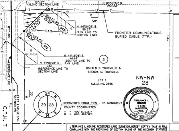

7 Existing Highway Easement (4)(a) Plat Detail and Format - Required Reference to other surveys of record and location of known monuments established for such surveys. Scale, North Arrow and Location of Known Public Land Survey Monuments. Coordinate Reference Note. (4)(a) Plat Detail and Format - Required Reference to other surveys of record and location of known monuments established for such surveys. Scale, North Arrow and Location of Known Public Land Survey Monuments. Coordinate Reference Note. (4)(a) Plat Detail and Format - Required Reference to other surveys of record and location of known monuments established for such surveys. Scale, North Arrow and Location of Known Public Land Survey Monuments. Coordinate Reference Note


(b) Plat Detail and Format - Required For Highway Projects, D (dd) x L/100 = Delta")
 649+13.88 + (L) 534.44 = (PT Sta.) 654 + 48.32 030114 8")
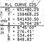
8 Coordinate Reference Note (4)(b) Plat Detail and Format - Required For Highway Projects, the following shall also be included: Designation of the highway and any adjacent or intersecting streets or highways by name, number, or letter. Description of the highway reference line by bearing and distance. A description of the highway right-of-way boundaries by bearing and distance. (4)(b) Plat Detail and Format - Required For Highway Projects, the following shall also be included: Designation of the highway and any adjacent or intersecting streets or highways by name, number, or letter. Description of the highway reference line by bearing and distance. A description of the highway right-of-way boundaries by bearing and distance. D (dd) x L/100 = Delta PI Sta. T = PC Sta. PC Sta. + L = PT Sta. (PI Sta.) (T) = (PC Sta.) (PC Sta.) (L) = (PT Sta.)

9 (4)(b) Plat Detail and Format - Required For Highway Projects, the following shall also be included: Designation of the highway and any adjacent or intersecting streets or highways by name, number, or letter. Description of the highway reference line by bearing and distance. A description of the highway right-of-way boundaries by bearing and distance. (4) Plat Detail and Format - Required Notwithstanding its depiction on a plat, the boundary of a parcel extends to the boundary of the adjoining property parcel or body of water. Property lines shown on this plat are drawn from data derived from maps and documents of public record and/or existing occupational lines. Excluding right-of-way boundaries, this plat may not be a true representation of existing property lines and should not be used as a substitute for an accurate field survey. (5) Surveyor s Certificate A plat prepared for filing or recording under this section shall include a certificate of a land surveyor registered under s that the plat is a correct representation of the project described and that the identification and location of each parcel can be determined from the plat. This subsection does apply to plats prepared by the department. (6) Plat Dimensions and Detail Any material that is capable of clearly legible reproduction (black on white) or other media acceptable to the Register of Deeds 22 wide by 30 long or of a size agreeable to the Register of Deeds office. i.e. such as 22 x 34 3 by 3 blank space for use by Register of Deeds


, (county name) register of deeds, and located in (quarter section, section, township and range; recorded private claim; or federal reservation).")
 Temporary Limited Easement (TLE) Scenic Easements Restricted De")

10 Electronically Recorded TPPs Wisconsin Electronic Recording Council (WERC) First TPP Recorded Electronically in Brown County Oct, 2010 Brown 276 Rock 65 Dane 259 Dodge - 4 Outagamie 289 Barron - 3 Portage 11 Jefferson - 3 Winnebago 63 Columbia - 2 Sheboygan 49 Racine - 15 Washington 6 St. Croix 26 La Crosse 14 Marquette - 12 Wood 3 Door 4 Chippewa Waupaca Waushara Sauk Iron Marinette Monroe Forest Waukesha Electronic Recording Partners Network (epn) Simplifile 60 Counties (7) Description for Parcels and Remainder Interests Whenever a plat has been filed or recorded under this section, any parcel depicted in the plat that is acquired for a project by conveyance or eminent domain proceedings shall be described as follows: Parcel (number) of transportation project plat (project number), recorded in volume (number) of transportation project plats, page (number), on (date), (county name) register of deeds, and located in (quarter section, section, township and range; recorded private claim; or federal reservation). Types of Acquisition Fee Highway Easements (HE) Permanent Limited Easement (PLE) Access Rights access controlled by new acquisition access restricted by previous project no access by statute authority no access (new highway) Temporary Limited Easement (TLE) Scenic Easements Restricted Development Easements Air Rights Project I.D Parcel 02 Envelope Description Fee title in and to the following tract of land in the Village of Iola, Waupaca County, State of Wisconsin, described as a parcel of land in the SW 1/4 of the SE 1/4 and the SE 1/4 of the SW 1/4 of Section 36, T 24 N, R 11 E, being a part of Lot 1, Waupaca Certified Survey 2331 recorded in volume 07 page 390 and lot 1 of Waupaca Certified Survey 5087 recorded in volume 16 page 269. Said parcel includes all that land of the owner contained within the following described traverse: Commencing at the Southwest corner of said Section 36; thence N " W along the section line for feet to the new reference line of S.T.H. 161 (Sta ) and the P.C. of a curve (mlcur9); thence along said curve to the right having a radius of feet, an arc distance of and long chord bearing S 70 32'34" E, feet; (central angle 14 '17"), to the end of the curve (Sta ); thence S E along said reference line for feet to the P.C. of a curve (Sta ) (mlcur10); thence along said curve to the left having a radius of feet, an arc distance of and long chord bearing S " E, feet; (central angle ") to the end of the curve (Sta ); and the P.C. of a curve (mlcur11); thence along said curve to the left having a radius of feet, and arc distance of and long chord bearing S " E, feet; (central angle ") to the end of the curve (Sta thence N " E along said reference line for feet to the Point of Beginning (Point A )(Sta ); thence continue N " E along said reference line for feet to a point (Sta ) and the P.C. of a curve (cur20); thence along said curve to the left having a radius of feet, an arc distance of feet and a long chord bearing N E, feet (central angle ) to the end of said curve (Sta ) and the intersection with the reference line of Keating Lake Road; thence S E along said reference line for feet to a point (Sta. 8 K +25); thence S Wfor feet to a monument (pt.no. cprw9); thence N W for feet to a monument (pt. no. cprw8); thence N W for feet to a monument (pt.no. cprw63); thence S W for feet to a monument (pt.no.cprw62); thence N W for 2.50 feet to a monument (pt.no.cprw61) thence S W for feet to a monument (pt.no. cprw2); thence N W for feet to a point (pt.no prw13); thence S W for feet to a point on the existing R/W of STH 161 (pt.no. prw 11); thence N W for feet and the Point of Beginning. Said parcel comprises 0.26 acres, more or less, exclusive of land previously acquired or now held for highway purposes. Also, a temporary limited highway easement for slope blending including for such purpose the right to operate necessary equipment thereon and the right of ingress and egress as long as required for such public purpose. Said easement consists of land contained within that part of the SW 1/4 of the SE 1/4 and the SE 1/4 of the SW 1/4 of Section 36, T 24 N, R 11 E, being a part of Lot 1, Waupaca Certified Survey 2331 recorded in volume 07 page 390 described as follows: A parcel of land 6 feet wide lying south of and parallel with a line connecting the above described points. Said easement contains 0.29 acres, more or less. This easement is to terminate upon completion of the Project for which this instrument is given


11 Legal Descriptions Lot and Block description referring to the filed Transportation Project Plat Parcel 14 of Transportation Project Plat , recorded in Volume 1 of Transportation Project Plats, Page 5, as Document number , recorded in Portage County, Wisconsin. Property interests and rights of said Parcel 14 consist of: Fee simple. Temporary Limited Easement. Permanent Limited Easement. Any interests or rights not listed above for said parcel but shown as required on said Transportation Project Plat are hereby incorporated herein by reference. Project I.D Page 1 of 1 Parcel 14 Legal Descriptions Lot and Block description referring to an Amended Transportation Project Plat Parcel 14 of Transportation Project Plat , Amendment 1, recorded in Volume 1 of Transportation Project Plats, Page 5, as Document number , recorded in Portage County, Wisconsin. Property interests and rights of said Parcel 14 consist of: Fee simple. Temporary Limited Easement. Permanent Limited Easement. Any interests or rights not listed above for said parcel but shown as required on said Transportation Project Plat are hereby incorporated herein by reference. Project I.D Page 1 of 1 Parcel 14 (8) Indexing of Plats Within 3 working days after the date on which a plat is submitted for recording under this section, the register of deeds shall assign a document number and volume and page of recording for the plat. (9) Local Review No state agency, city, village, town, or county may require the review or approval of a plat as a condition of filing or recording the plat if the plat is prepared in accordance with this section. Wisconsin DOT Facilities Development Manual Chapter Additional Requirements for Transportation Project Plats Location Description Location Description Boundary Point labels Stations and Outs Show all Utilities where any Part is Compensable Show Recording Information for Utility Easements Access Control


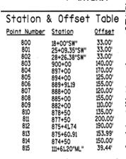

12 Location Description Boundary Point Labels Stations and Outs Show all Utilities where any Part is Compensable Show Recording Information for Utility Easements Access Control Stations and Offsets Location Description Boundary Point Labels Stations and Outs Show all Utilities where any Part is Compensable Show Recording Information for Utility Easements Access Control Location Description Boundary Point Labels Stations and Outs Show all Utilities where any Part is Compensable Show Recording Information for Utility Easements Access Control


13 Location Description Boundary Point Labels Stations and Outs Show all Utilities where any Part is Compensable Show Recording Information for Utility Easements Access Control Location Description Boundary Point Labels Stations and Outs Show all Utilities where any Part is Compensable Show Recording Information for Utility Easements Access Control For Current Access/Driveway Information, Contact the Planning Unit of the Wisconsin Department of Transportation Region Office in (City). Check the Deed Triangle Access Symbol Legal Description w/access Rights Parcel 14 of Transportation Project Plat , recorded in Volume 1 of Transportation Project Plats, Page 5, as document , recorded in Portage County, Wisconsin. Property interests and rights of said Parcel 14 consist of: Fee Simple. Access Rights, described as follows: All existing, future, or potential rights of ingress or egress between the highway currently designated as STH 33 and all of the abutting remaining real property of the owner(s), whether acquired by separate conveyance or otherwise, as shown on said Transportation Project Plat Except the grantor reserves the common law right subject to police power regulation, to the following: One driveway connection to the highway currently designated as STH 33 from the above described lands on the northerly side of STH 33. The driveway connection is subject to the rules, regulations and permitting requirements of the driveway permitting authority. NOTICE: Under state law, driveway connections to highways from abutting lands are subject to police power regulation and any driveway connection may be modified by the maintaining authority for the highway as conditions warrant or may be eliminated if reasonable alternative access to the property exists. Said driveway connection is subject to the following conditions: Said driveway connection shall be used for one single-family residence only. Said driveway connection shall be located in the east 800 feet of the NW1/4-NW1/4 of Section 5 T22N, R8E, Portage County, Wisconsin as measured along the south line of said NW1/4-NW1/4. Any interests or rights not listed above for said parcel but shown as required on said Transportation Project Plat are hereby incorporated herein by reference. Project I.D Page 1 of 1 Parcel
 and Off- Premise Sign Parcel 18 of")

, whether acquired by separate conveyance or otherwise, as shown on said Transportation Project Plat 5121-09-21-4.10.")

14 Off Premise Signs and Sign Schedule Off Premise Signs Temporary Limited Easements (TLE s) Permanent Limited Easements (PLE s) Hatching/Shading for all Interests Conventional Signs and Abbreviations Trans 233 Notes Legal Description including Off Premise Sign Language Example 12 - FEE SIMPLE with ACCESS RIGHTS (allowing a Driveway Connection at any location) and Off- Premise Sign Parcel 18 of Transportation Project Plat , recorded in Cabinet 1 of Transportation Project Plats, Page 2, as Document , recorded in La Crosse County, Wisconsin. Property interests and rights of said Parcel 18 consist of: Fee simple. Access rights, described as follows: All existing, future or potential common law or statutory easements or rights of access between the highway currently designated as STH 33 and all of the abutting remaining real property of the owner(s), whether acquired by separate conveyance or otherwise, as shown on said Transportation Project Plat Except the grantee will allow, upon request, the common law right, subject to police power regulation, one driveway connection to said highway from said abutting lands on the southerly side of said highway. The driveway connection is subject to the rules and regulations of the driveway permitting authority, and may be modified by the grantee or its successors or assigns as future conditions warrant and revoked when reasonable alternative access exists. Also, included herein is all right, title and interest in and to any outdoor advertising sign site and sign structure including leasehold or permit interests, related to the sign known as OASIS number xxxxx (if applicable). Any interests or rights not listed above for said parcel but shown as required on said Transportation Project Plat are hereby incorporated herein by reference. Project I.D Page 1 of 1 Parcel 18 Off Premise Signs Temporary Limited Easements (TLE s) Permanent Limited Easements (PLE s) Hatching/Shading for all Interests Conventional Signs and Abbreviations Trans 233 Notes Temporary Limited Easements (TLE) and Permanent Limited Easements (PLE) Off Premise Signs Temporary Limited Easements (TLE s) Permanent Limited Easements (PLE s) Hatching/Shading for all Interests Conventional Signs and Abbreviations Trans 233 Notes


15 Off Premise Signs Temporary Limited Easements (TLE s) Permanent Limited Easements (PLE s) Hatching/Shading for all Interests Conventional Signs and Abbreviations Trans 233 Notes Off Premise Signs Temporary Limited Easements (TLE s) Permanent Limited Easements (PLE s) Hatching/Shading for all Interests Conventional Signs and Abbreviations Trans 233 Notes Trans 233 Show and Reference Trans 233 Access Restrictions Reference Recorded Document Highway Setbacks Trans 233 Restrictions Apply


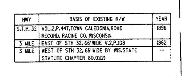
16 Off Premise Signs Temporary Limited Easements (TLE s) Permanent Limited Easements (PLE s) Hatching/Shading for all Interests Conventional Signs and Abbreviations Trans 233 Notes Primary Buildings within 100 feet of R/W Basis of Existing Highway Right-of-Way Appraisal Plat Date & Relocation Order Approval Date Closed Boundary Traverse Transportation Project Plat Checklist slide 101 Primary Buildings within 100 feet of R/W Basis of Existing Highway Right-of-Way Appraisal Plat Date & Relocation Order Approval Date Closed Boundary Traverse Transportation Project Plat Checklist


17 Primary Buildings within 100 feet of R/W Appraisal Plat Date Basis of Existing Highway Right-of-Way Appraisal Plat Date & Relocation Order Approval Date Closed Boundary Traverse Transportation Project Plat Checklist Relocation Order Approval Date Actions Surrounding Relocation Order Approval Prior to Relocation Order Approval: Appraiser will use unrecorded plat sheet and reference the plat appraisal date to identify the version used. Reviewer may approve Sales Study (Data Book) for nominal waiver of appraisals under $10k. Reviewer may review appraisal report. After Relocation Order Approval: RE Management may approve Nominal Payment Parcel Report. Reviewers may approve Offering Price Real Estate can initiate negotiations once an offering price has been approved. Property Owner cannot sign a deed or a JO cannot be issued until the TPP is recorded. Primary Buildings within 100 feet of R/W Basis of Existing Highway Right-of-Way Appraisal Plat Date & Relocation Order Approval Date Closed Boundary Traverse Transportation Project Plat Checklist

18 Primary Buildings within 100 feet of R/W Basis of Existing Highway Right-of-Way Appraisal Plat Date Closed Boundary Traverse Transportation Project Plat Checklist Plan and Profile Needed for Additional Information Topographic Information May not be shown on Plat Wells, septic tanks, and tile fields Fence lines Driveways and entrances to highways Slope intercepts Trees and shrubs Encroachments Municipal Utilities Sewer and Water Utility Easements Coordinates on R/W points Recording Process Consultants will Send Sealed and Signed Transportation Project Plat to Regional Office for Review and Approval. May be Submitted Electronically. Regional Office will Approve and Sign Transportation Project Plat. Regional Office will send Transportation Project Plat to WisDOT Central Office for Review and Creation of document acceptable to the Register of Deeds. Central Office will send Transportation Project Plat document to County Register of Deeds Office for Filing/Recording. Date Transportation Project Plat is signed in Regional Office is the relocation order approval date. County Register of Deeds Office will place recording information on TPP document, Photocopy Recording Information and Recording Information back to Regional Office. WisDOT Plat Coordinators Regional Contacts Northwest Superior Tom Armstrong, PLS Northwest Eau Claire Bill Holme, PLS Southwest La Crosse Joerg Feldbinder, PLS Northcentral Wisconsin Rapids/Rhinelander Jeff Brock, PLS Southwest Madison Keif Callaway, PLS Northeast Green Bay Greg Belanger, PLS Southeast Waukesha Paul Munia, PLS For Further Guidance: Check out Chapter 12 of the Facilities Development Manual online at Contact Regional Plat Coordinator or contact Rodney Key, R.L.S

19 ?????? Questions?????? Rodney Key, P.L.S
Map Filing Law. 46: Effective date This act shall take effect January first, one thousand nine hundred and fiftyfour.
 46:23-9.8. Effective date This act shall take effect January first, one thousand nine hundred and fiftyfour. L.1953, c. 358, p. 1941, s. 8. 46:23-9.9. Short title This act shall be known and may be cited
R/W PREQUALIFICATION ODOT, 3/14/2018 PROPERTY MAP SHEET
 R/W PREQUALIFICATION ODOT, 3/14/2018 3A Title Block 3B Sheet Heading 3C Station Limit Flags 3D Revision Block 3E Ownership Name and Number 3F Centerline Stationing 3G Proposed R/W and Pavement 3H Structures
Plan Presentation Guide SECTION 60. Chapter 3 RIGHT-OF-WAY SECTION PRESENTATION
 Chapter 3 RIGHT-OF-WAY SECTION PRESENTATION Right of Way plans are necessary for the acquisition of the required right of way and easements for projects. Proper representation of the right of way and easements
Standards of Practice for Surveying in the State of Alabama
 Standards of Practice for Surveying in the State of Alabama Effective January 1, 2017 RULE NO. 1.01 PURPOSE The purpose of these rules is to establish standards for the practice of surveying in the State
DRAINAGE AND UTILITY EASEMENT. That Bruce Conrad, a single adult, hereinafter referred to as Grantor for good and
 DRAINAGE AND UTILITY EASEMENT KNOW ALL PERSONS BY THESE PRESENTS: That Bruce Conrad, a single adult, hereinafter referred to as Grantor for good and valuable consideration, the receipt and sufficiency
PLYMOUTH PLANNING BOARD APPLICATION FOR A MINOR SUBDIVISION OR MAJOR SUBDIVISION
 CASE # PLYMOUTH PLANNING BOARD APPLICATION FOR A MINOR SUBDIVISION OR MAJOR SUBDIVISION The undersigned Applicant hereby submits to the Plymouth Planning Board a completed application for a proposed minor
Change In The Name Of Owner (s) Of Land.
 Of Land.") Clermont County TRANSFER AND CONVEYANCE STANDARDS OF THE CLERMONT COUNTY AUDITOR AND THE CLERMONT COUNTY ENGINEER AS ADOPTED UNDER OHIO REVISED CODE SECTION 319.203, AS A RESULT OF TWO PUBLIC HEARINGS
Clermont County TRANSFER AND CONVEYANCE STANDARDS OF THE CLERMONT COUNTY AUDITOR AND THE CLERMONT COUNTY ENGINEER AS ADOPTED UNDER OHIO REVISED CODE SECTION 319.203, AS A RESULT OF TWO PUBLIC HEARINGS
Department of Development Services Engineering; Survey Plat Review Group SPRG
 Department of Development Services Engineering; Survey Plat Review Group SPRG CITY OF DALLAS LEGAL DESCRIPTION PREPARATION GUIDELINE AND CHECKLIST The following guideline and checklist are provided to
MINNESOTA ASSOCIATION OF COUNTYSURVEYORS MANUAL OF MINIMUM GUIDELINES FOR THE PREPARATION OF COUNTY HIGHWAY RIGHT-OF-WAY PLATS
 MINNESOTA ASSOCIATION OF COUNTYSURVEYORS MANUAL OF MINIMUM GUIDELINES FOR THE PREPARATION OF COUNTY HIGHWAY RIGHT-OF-WAY PLATS MARCH,1994 j RECOMMENDED BY: MINNESOTA ASSOCIATION OF COUNTY SURVEYORS MINNESOTA
Oakland County Michigan Register of Deeds Plat Engineering, GIS, & Remonumentation Dept. Ph: (248) Fax (248)
 Fax (248)") Oakland County Michigan Register of Deeds Plat Engineering, GIS, & Remonumentation Dept. Ph: (248)-858-1447 Fax (248)-858-7466 Requirements Needed for Final Plat Approval No. General Requirements. 1 Routing
Oakland County Michigan Register of Deeds Plat Engineering, GIS, & Remonumentation Dept. Ph: (248)-858-1447 Fax (248)-858-7466 Requirements Needed for Final Plat Approval No. General Requirements. 1 Routing
R/W PREQUALIFICATION ODOT, 3/14/2018
 R/W PREQUALIFICATION ODOT, 3/14/2018 BRETT SHEARER, C.O. REAL ESTATE PROPOSED RIGHT OF WAY DESIGN 172 PROPOSED RIGHT OF WAY DESIGN PROPOSED RIGHT OF WAY DESIGN Section 3200 Types of Title 173 PROPOSED
FINAL PLAT CHECKLIST
 FINAL PLAT CHECKLIST Project Name: Tax ID #: Project Number: Date: _ Reviewed By: Telephone: Please address all items marked with an "X" Please return redline comments with corrected plan, original mylar,
MINOR SUBDIVISION PLAT CHECKLIST
 MINOR SUBDIVISION PLAT CHECKLIST Project Name: Tax ID #: Project Number: Date: _ Reviewed By: Telephone: NOTES: All lots on septic systems must comply with the Fulton County Health Department requirements
SUBDIVISION APPLICATION CHECKLIST SKETCH PLAN PRELIMINARY PLAT FINAL PLAT
 RECEIVED STAMP SUBDIVISION APPLICATION CHECKLIST SKETCH PLAN PRELIMINARY PLAT FINAL PLAT A checklist of background information and submission requirements for processing of a sketch plan, preliminary plat
2018 EASEMENT DEDICATION PACKET
 2018 EASEMENT DEDICATION PACKET (INCLUDES PARCELS OF LAND, EASEMENTS, AND RIGHTS-OF-WAY FOR PUBLIC USE) Information Packet There are various situations in which easements, rights-of-way, and parcels of
Requirements for All Instruments of Conveyance in Logan County, Ohio
 Requirements for All Instruments of Conveyance in Logan County, Ohio Effective Date: April 11, 1997 It is the intent of these requirements to provide a standard method of checking legal descriptions for
STANDARDS GOVERNING CONVEYANCES OF REAL PROPERTY IN DARKE COUNTY, OHIO
 STANDARDS GOVERNING CONVEYANCES OF REAL PROPERTY IN DARKE COUNTY, OHIO As directed by Section 319.203 of the Ohio Revised Code which states The County Auditor and the County Engineer shall adopt standards
STANDARDIZED LEGAL DESCRIPTIONS AND EXHIBITS
 STANDARDIZED LEGAL DESCRIPTIONS AND EXHIBITS Public Works Department, Engineering Division June 14, 2004 UNIFIED GOVERNMENT STANDARDIZED LEGAL DESCRIPTIONS AND EXHIBITS For: Roads, Bridges, Short Span
RULES OF THE GEORGIA STATE BOARD OF REGISTRATION FOR PROFESSIONAL ENGINEERS AND LAND SURVEYORS CHAPTER APPLICATIONS TABLE OF CONTENTS
 RULES OF THE GEORGIA STATE BOARD OF REGISTRATION FOR PROFESSIONAL ENGINEERS AND LAND SURVEYORS CHAPTER 180-7 APPLICATIONS TABLE OF CONTENTS 180-7-.07 Maps and Plats. All maps, plats and similar documents
Survey and Recording Requirements
 Article C: Sec. 14-1-40 Survey and Recording Requirements Survey Requirements. (a) (b) (c) Prior to the final approval of land divisions to which this Chapter applies, the owner of the land shall have
Requirements For All Instruments of Conveyance In Monroe County, Ohio. Transfer and Conveyance Standards of the Monroe County Auditor & Engineer
 Requirements For All Instruments of Conveyance In Monroe County, Ohio Transfer and Conveyance Standards of the Monroe County Auditor & Engineer Effective November 8, 2013 1 TRANSFER PROCEDURES FOR MONROE
SUBDIVISION APPLICATION INSTRUCTIONS
 SUBDIVISION APPLICATION INSTRUCTIONS APPLICATION FORM The application form must be fully completed, signed by the property owner and shall be properly notarized. AGENT AUTHORIZATION FORM If the applicant
CONVEYANCE - COMMONWEALTH PROPERTY IN THE BOROUGH OF EAST STROUDSBURG, MONROE COUNTY Act of Jul. 1, 2016, P.L., No. 65 Cl.
 CONVEYANCE - COMMONWEALTH PROPERTY IN THE BOROUGH OF EAST STROUDSBURG, MONROE COUNTY Act of Jul. 1, 2016, P.L., No. 65 Cl. 85 An Act Authorizing the Department of General Services, with the approval of
DALLAS WATER UTILITIES WATER/WASTEWATER COVENANT
 DALLAS WATER UTILITIES WATER/WASTEWATER COVENANT Procedure for obtaining a water and wastewater covenant, water covenant, or wastewater covenant; Required for initial submittal: 1. One letter from the
DEED AND DEDICATION FOR PUBLIC RIGHT OF WAY
 TO : BOARD OF DIRECTORS FROM : GARY PLATT, EXEC. DIRECTOR BUSINESS AND OPERATIONS SUBJECT : CITY OF STANWOOD CONSTRUCTION EASEMENT AND RIGHT-OF-WAY DEDICATION DATE : MARCH 17, 2009 TYPE : ACTION NEEDED
CARROLL COUNTY BUREAU OF DEVELOPMENT REVIEW OFF-CONVEYANCE SUBMITTAL CHECKLIST AND REVIEW FEE SHEET NOTICE: INCOMPLETE SUBMITTALS WILL BE RETURNED
 CARROLL COUNTY BUREAU OF DEVELOPMENT REVIEW OFF-CONVEYANCE SUBMITTAL CHECKLIST AND REVIEW FEE SHEET An off-conveyance submittal shall include all items as specified in Section 103-7 of the Code of Public
COACHELLA VALLEY WATER DISTRICT STANDARDS FOR LEGAL DESCRIPTIONS AND PLATS
 COACHELLA VALLEY WATER DISTRICT STANDARDS FOR LEGAL DESCRIPTIONS AND PLATS The following is the procedure for processing legal descriptions and plats (exhibits) for grants of easements, grant deeds, quitclaim
OTTAWA COUNTY LEGAL DESCRIPTION REVIEW GUIDELINES
 OTTAWA COUNTY LEGAL DESCRIPTION REVIEW GUIDELINES APPROVED BY: RONALD P. LAJTI, JR., P.E., P.S. OTTAWA COUNTY ENGINEER APPROVED BY: LAWRENCE HARTLAUB OTTAWA COUNTY AUDITOR EFFECTIVE DATE: January 1, 2017
Application for Preliminary Plat Checklist
 Application for Preliminary Plat Checklist Note: No portion of an existing parcel may be sold or transferred to another party without first legally subdividing the property according to the City of Richmond
Division of Land Application
 FOR PLANNING USE ONLY Application # DIV Application Fee Receipt No. Filing Date Completeness Date Division of Land Application A. PROJECT INFORMATION 1. Project Name: 2. Address of Subject Property: 3.
WYANDOT COUNTY BASIC STANDARDS FOR THE APPROVAL OF REAL ESTATE DEED TRANSFERS & LAND CONTRACT AGREEMENTS
 GENERAL In compliance with Section 315.251 of the Ohio Revised Code, the County Auditor and the County Engineer have adopted these written standards governing the conveyance of real property in Wyandot
Sketch & Legal Description of Mitigation Bank and Ingress/Egress Access Easements
 Appendix H: Sketch & Legal Description of Mitigation Bank and Ingress/Egress Access Easements Tippen Bay Wetland Mitigation Bank DeSoto County, Florida Prepared by: September, 2017 Original file
Easements, Establishments, Abandonments and Vacations
 Easements, Establishments, Abandonments and Vacations A highway easement conveys, in perpetuity, the right to construct and maintain a highway facility on the land of the fee holder. (Property owner) The
Record Year on Track for Wisconsin Housing Market
 Date: 10/17/2016 For Release: Immediately For More Information Contact: Michael Theo, WRA President & CEO, 608-241-2047, mtheo@wra.org or David Clark, Economist, C3 Statistical Solutions and Professor
WASTEWATER BACKFLOW RELEASE PROCEDURES
 WASTEWATER BACKFLOW RELEASE PROCEDURES PROCEDURE FOR OBTAINING A WASTEWATER RELEASE FOR PRIVATE DEVELOPMENT PROJECTS: PLEASE NOTE THAT THE WASTEWATER BACKFLOW RELEASE DOCUMENT MUST FOLLOW THE CITY S PROCEDURES.
CERTIFIED SURVEY MAP
 SCONSIN STATE PLANE N:389676.12 E:2130390.15 Center of Section 23 CERTIFIED SURVEY MAP 734.06' THE (PRITCHETTE) ORIGINAL PLAT OF ALL IN THE NW 1 4 OF THE SE 1 4 OF FRACTIONAL SECTION 23, T7N, R9E, IN THE
DAWSON COUNTY MINOR PLAT REVIEW CHECKLIST $50.00 FEE PER PLAT REVIEW, $5.00 FEE FOR SCAN & CD FOR RECORDING
 DAWSON COUNTY MINOR PLAT REVIEW CHECKLIST $50.00 FEE PER PLAT REVIEW, $5.00 FEE FOR SCAN & CD FOR RECORDING NAME ON PLAT: CONTACT/PHONE #: NAMED STREET/ADDRESS: LAND LOT: DISTRICT: SECTION: ZONING: SETBACKS:
SUBMITTAL REQUIREMENTS: The number indicates the number of copies for submittal (if applicable).
.") Office Use Only Preliminary Long Plat Long Subdivision Applicant Checklist PLANNING, COMMUNITY, & ECONOMIC DEVELOPMENT DEPARTMENT FINAL LONG PLAT LONG SUBDIVISION CHECKLIST Mailing Address: P.O. Box 547,
Office Use Only Preliminary Long Plat Long Subdivision Applicant Checklist PLANNING, COMMUNITY, & ECONOMIC DEVELOPMENT DEPARTMENT FINAL LONG PLAT LONG SUBDIVISION CHECKLIST Mailing Address: P.O. Box 547,
LAND USE PERMIT APPLICATION
 LAND USE PERMIT APPLICATION Date Application No. TYPE OF PERMIT Subdivision Short Plat Conditional Use Binding Site Plan Final Plat Final Short Plat Variance Final Binding Site Plan Plat Amendment Short
Plats and subdivisions; mapping requirements. (a) Size Requirements. All land plats presented to the register of deeds for recording in the
 Size Requirements. All land plats presented to the register of deeds for recording in the") 47-30. Plats and subdivisions; mapping requirements. (a) Size Requirements. All land plats presented to the register of deeds for recording in the registry of a county in North Carolina after September
47-30. Plats and subdivisions; mapping requirements. (a) Size Requirements. All land plats presented to the register of deeds for recording in the registry of a county in North Carolina after September
Request for Action form is also defined as an application to be considered by the Planning Commission.
 CITY OF NORTH RIDGEVILLE INSTRUCTIONS FOR FILING REQUEST FOR ACTION APPLICATIONS WITH THE PLANNING COMMISSION (Please read the full instruction as it will help in providing a full complete application)
APPLICATION PROCEDURE
 ANTRIM PLANNING BOARD P. O. Box 517 Antrim, New Hampshire 03440 Phone: 603-588-6785 FAX: 603-588-2969 APPLICATION FORM AND CHECKLIST FOR MINOR OR MAJOR SITE PLAN REVIEW File Date Received By APPLICATION
Township of Little Egg Harbor Planning Board 665 Radio Road Little Egg Harbor, New Jersey Phone: ext. 221 Fax:
 BLOCK(S) LOT(S) Township of Little Egg Harbor Planning Board 665 Radio Road Little Egg Harbor, New Jersey 08087 Phone: 609-296-7241 ext. 221 Fax: 609-294-3040 Development Application Amended Development
Standards for All Instruments of Conveyance
 Standards for All Instruments of Conveyance Perry County, Ohio Effective Date: May 1, 1997 Effective Date of Revision: April 1, 2011 Page 2 of 12 Minimum Standards for all Instruments of Conveyance Perry
The Filing Fee for a Minor Plat is $ PLUS $20.00 per lot created
 DEPARTMENT OF COMMUNITY DEVELOPMENT MINOR PLAT PROCEDURE The Filing Fee for a Minor Plat is $250.00 PLUS $20.00 per lot created Description: The purpose of a Minor Plat is to allow property to be platted
Final Plat Mapping Requirements
 CURRENT PLANNING DIVISION 410 E. 5 th Street Loveland, CO 80537 970-962-2523 eplan-planning@cityofloveland.org cityofloveland.org/dc Final Plat Mapping Requirements All Final plats shall comply with the
Easements, Establishments, Abandonments and Vacations
 Easements, Establishments, Abandonments and Vacations Highway Easements: Where there is a right to construct and maintain a highway facility SH - Standard Highway easement LA - Limited Access Easement
A. Appropriate agency responsible for transportation review for the subject property.
 7.8.10 Procedure Any person desiring to create a minor subdivision shall submit to the Commission for approval an application on forms provided by the Division, and a record plat in conformance with the
HOME SALES RALLY IN THE FOURTH QUARTER TO KEEP WISCONSIN HOUSING MARKET STABLE
 Date: 2/11/2010 For Release: Immediately For More Information Contact: David E. Clark, Economist C3 Statistical Solutions Inc. Office phone: 414-803-6537 or William Malkasian, President Wisconsin REALTORS
City of Fort Lupton Amended Plat Process
 City of Fort Lupton Amended Plat Process Purpose The Amended Plat process is an administrative process to amend a recorded Plat. An Amended Subdivision is an administrative revision to a recorded Subdivision
2018 Housing Market Remains Strong Despite Limited Inventories
 Date: 1/21/19 For Release: Immediately For More Information Contact: Michael Theo, WRA President & CEO, 608-241-2047, mtheo@wra.org or David Clark, Economist, C3 Statistical Solutions and Professor of
INSTRUCTIONS FINAL PLAT APPROVAL APPLICATION
 INSTRUCTIONS FINAL PLAT APPROVAL APPLICATION 1. The applicant/agent shall fill out the attached application. The attached application form must be completely filled in before it can be filed. Portions
SUBMITTAL REQUIREMENTS: The number indicates the number of copies for submittal (if applicable).
.") Office Use Only Preliminary Long Plat Long Subdivision Applicant Checklist PLANNING, COMMUNITY, & ECONOMIC DEVELOPMENT DEPARTMENT PRELIMINARY LONG PLAT LONG SUBDIVISION CHECKLIST Mailing Address: P.O.
Office Use Only Preliminary Long Plat Long Subdivision Applicant Checklist PLANNING, COMMUNITY, & ECONOMIC DEVELOPMENT DEPARTMENT PRELIMINARY LONG PLAT LONG SUBDIVISION CHECKLIST Mailing Address: P.O.
APPENDIX C: PLAT SPECIFICATIONS AND CERTIFICATES
 APPENDIX C: PLAT SPECIFICATIONS AND CERTIFICATES A. Drawing. All plats for recording must be submitted on photographically reproducible and dimensionally stable polyester sheets such as Mylar, Cronar or
Rule 21 STANDARDS OF PRACTICE FOR SURVEYING
 Rule 21 STANDARDS OF PRACTICE FOR SURVEYING 21.1 Whenever a survey is performed, it shall comply with Section 73-13-71 (4) and Section 73-13- 73 and the Standards of Practice for Surveying in Mississippi
PRELIMINARY PLAT CHECK LIST
 PRELIMINARY PLAT CHECK LIST Name of Proposed Subdivision: The following items must be included with the initial submittal of a Preliminary Plat: Application, filled out completely Project Narrative Pre-application
Welcome to District 6-0
 Welcome to District 6-0 Introductions Traffic Services Manager Fran Hanney 610.205.6560 fhanney@pa.gov District Permits Manager Matthew Miele 610.205.6795 mmiele@pa.gov Right-of-Way Administrator Matthew
Final Plat Review Checklist Church Lake Estates Title 18F Development Engineering Review
 Pierce County Department of Planning and Land Services DENNIS HANBERG Director 2401 South 35 th Street Tacoma, Washington 98409-7460 Final Plat Review Checklist Church Lake Estates Title 18F Development
AN ACT. The General Assembly of the Commonwealth of Pennsylvania hereby enacts as follows:
 CONVEYANCES - COMMONWEALTH PROPERTY IN LIGONIER BOROUGH, WEST MORELAND COUNTY; CITY OF CONNELLSVILLE, FAYETTE COUNTY; CITY OF ALLENTOWN, LEHIGH COUNTY; BENSALEM TOWNSHIP, BUCKS COUNTY, AND SUSQUEHANNA
ARTICLE 900 PLAT AND PLAN REQUIREMENTS
 ARTICLE 900 PLAT AND PLAN REQUIREMENTS SEC. 900.1 ITEMS TO BE SHOWN ON PLAT OR PLAN General (1) Property lines of all property owners adjacent to the exterior boundaries of the project shall be located
SECTION 6 - APPROVAL OF PLATS. Whenever any subdivision of land is proposed, and before any permit for the
 SECTION 6 - APPROVAL OF PLATS 6-1 APPROVAL REQUIRED BEFORE SALE Whenever any subdivision of land is proposed, and before any permit for the erection of a structure shall be granted, the subdivider or his
FINAL PLAT APPLICATION
 FINAL PLAT APPLICATION (Page 1 of 3) LEGAL OWNER(s): NAME: STREET ADDRESS OWNER(s): CITY, STATE, ZIP CODE: PHONE NUMBER: BILLING ADDRESS: NAME OF ENGINEER/SURVEYOR: Engineer/Surveyor Address, Phone: PROPERTY
COUNCIL AGENDA MEMO ITEM NO. III - #1
 COUNCIL AGENDA MEMO ITEM NO. III - #1 FROM: Anton Jelinek, Director of Utilities MEETING: October 24, 2017 SUBJECT: PRESENTER: Permanent Utility and Right-of-Way Easement Anton Jelinek Discussion: At the
BRIDGETON SUBDIVISION APPLICATION CHECKLIST
 APPLICATION NAME AND # CHECKLIST COMPLETED BY: DATE: Signature and printed name BRIDGETON SUBDIVISION APPLICATION CHECKLIST TO SUBDIVISION APPLICANTS: The attached checklist is to assist you in the submission
SUBDIVISION APPLICATION
 SUBDIVISION APPLICATION City of Horn Lake Planning Department 3101 Goodman Road, W Horn Lake, MS 38637 662-342-3559 Fax: 662-342-3485 Applications due the 1st working day of the month. Submit application
January Home Sales Fall as Prices Continue to Rise
 Date: 2/23/15 For Release: Immediately For More Information Contact: Michael Theo, WRA President & CEO, 608-241-2047, mtheo@wra.org or David Clark, Economist, C3 Statistical Solutions and Professor of
7. EASEMENTS Label Established Lines Affecting Tract and/or Mentioned in its Legal Description:
 7. EASEMENTS 7.010 General All sewers shall be constructed in easements with working room. Existing easements without working room may only be used if revised to include working room. All public sewers,
Final Plat Approval of a Major Subdivision Application Packet
 Final Plat Approval of a Major Subdivision Application Packet 1. Application Packet. Be sure to complete and submit all the required materials that are a part of this Application Packet. Failure to do
Waseca County Planning and Zoning Office
 Waseca County Planning and Zoning Office 300 North State Street Waseca, Minnesota 56093 Phone: 507-835-0650 Fax: 507-837-5310 Form no. PZ 081009 Web Site: www.co.waseca.mn.us FEES: 1) CUP FEE- $400.00
Limited Supply of Homes for Sale Impacts Prices and Sales
 Date: 2/20/17 For Release: Immediately For More Information Contact: Michael Theo, WRA President & CEO, 608-241-2047, mtheo@wra.org or David Clark, Economist, C3 Statistical Solutions and Professor of
STANDARDS GOVERNING CONVEYANCES OF REAL PROPERTY
 STANDARDS GOVERNING CONVEYANCES OF REAL PROPERTY Hancock County, Ohio Charity A. Rauschenberg, Hancock County Auditor Steven C. Wilson, Hancock County Engineer Revised: March 1, 2007 TRANSFER AND CONVEYANCE
PRELMINARY PLAT CHECKLIST
 PRELMINARY PLAT CHECKLIST A. All preliminary plat submitted for approval shall be prepared by a Registered Professional Land Surveyor. B. Preliminary plats must be drawn to a scale of XXX with such accuracy
To provide for the review of the final engineering plans, the subdivision improvement agreement, public dedications, and other legal agreements.
 ARTICLE 5 FINAL PLAT 501 Intent DOUGLAS COUNTY SUBDIVISION RESOLUTION To provide for the review of the final engineering plans, the subdivision improvement agreement, public dedications, and other legal
Presented by: Michael G. Geier, PLS Snyder & Associates, Inc.
 Presented by: Michael G. Geier, PLS Snyder & Associates, Inc. Background Society of Land Surveyors of Iowa (SLSI) Iowa County Recorders Association (ICRA) Iowa Land Records (ILR) Started a process three
PLANNING SERVICES MEMORANDUM
 PLANNING SERVICES MEMORANDUM March 13, 2017 TO: FROM: SUBJECT: City Council Brian Schweigl, Associate Planner Consideration and action on final Certified Survey Map (CSM) 17002-C, City of Janesville, 2
APPROVAL REQUIREMENTS
 APPROVAL REQUIREMENTS FOR INSTRUMENTS OF CONVEYANCE IN ERIE COUNTY, OHIO DRAFT Requirements for all instruments of Conveyance in Erie County, revised and effective, 2014. An Erie County policy governing
ORDINANCE NO AN ORDINANCE To Be Entitled:
 3808 AN ORDINANCE To Be Entitled: AN ORDINANCE OF THE CITY COUNCIL OF THE CITY OF FORT MYERS, FLORIDA, REZONING FROM COMMERCIAL GENERAL TO PLANNED UNIT DEVELOPMENT AND APPROVING THE DEVELOPMENT PLAN FOR
Township of Collier 2418 Hilltop Road Presto, PA 15142
 Township of Collier 2418 Hilltop Road Presto, PA 15142 Fees: Major: 2 checks $600 + $50 per lot & $1700 Escrow) APPLICATION FOR SUBDIVISION major FINAL only Plans must be folded Rolled plans will not be
Submittal Requirements: Subdivision Plat (Final)
") s Planning and Zoning Submittal Requirements: Subdivision Plat (Final) 1. Application form, APO fees, and filing fee. Transportation Development Review Fee please contact Engineering at (970) 221-6605
s Planning and Zoning Submittal Requirements: Subdivision Plat (Final) 1. Application form, APO fees, and filing fee. Transportation Development Review Fee please contact Engineering at (970) 221-6605
In Rem Foreclosure of Tax Liens By Lafayette County For Tax Years
 In Rem Foreclosure of Tax Liens By Lafayette County For Tax Years 2007-2011 Properties owned by Lafayette County, WI Sealed Bid Auction Date: November 13, 2015 Sealed Bid Auction Time: 11:00 a.m. Sealed
SUBDIVISION AND LAND DEVELOPMENT. 185 Attachment 20
 185 Attachment 20 APPENDIX S Plat No. Date of Submission Twp. Fee $ Dauphin Co. Fee $ TOWNSHIP OF DERRY SUBDIVISION OR LAND DEVELOPMENT PLAN SUBMISSION APPLICATION This block for Twp. use only 1. Title
JEFFERSON COUNTY, ALABAMA
 JEFFERSON COUNTY, ALABAMA Major Development Checklist, Notes and Information A Major Development is any proposed new structure or addition to an existing structure which will cause a change in the topography
COUNTY OF ALBEMARLE APPLICATION FOR FAMILY DIVISION. Family Division = $742 (Provide 5 copies of plat)
") Page 1 APPLICATION FOR FAMILY DIVISION Family Division = $742 (Provide 5 copies of plat) Tier 2 Groundwater Review = $355 (Required for all plats showing lots less than 21 acres) Tier 3 Groundwater Review
Page 1 APPLICATION FOR FAMILY DIVISION Family Division = $742 (Provide 5 copies of plat) Tier 2 Groundwater Review = $355 (Required for all plats showing lots less than 21 acres) Tier 3 Groundwater Review
MAJOR RESIDENTIAL AND NONRESIDENTIAL SUBDIVISIONS
 MAJOR RESIDENTIAL AND NONRESIDENTIAL SUBDIVISIONS Final Plats The applicant shall schedule a Pre-Application meeting with Planning Staff at least seven (7) working days prior to submittal of the application.
STANDARD LANGUAGE FORMAT GUIDE PLANNING SERVICES DIVISION
 A. OWNERSHIP CERTIFICATE The purpose of the ownership certificate is to identify the owner and provide the Volume and Page of Deed Records, verifying the ownership. When the property owner is a corporation,
PARCEL MAP CHECK ENG
 Engineering Division 201 North Broadway, Escondido, CA 92025 (760) 839-4651, FAX (760) 839-4597 PARCEL MAP CHECK ENG To: Date: Project: Site Address Check No. Attn: Via: The attached plans have been reviewed
2401 S. E. Monterey Road, Stuart, FL Plat Application Martin County Growth Management Department
 Martin County, Florida Growth Management Department DEVELOPMENT REVIEW DIVISION PLAT APPLICATION A. Identification of the applicant or agent: Applicant (property owner): Address: Telephone: Applicant's
TRANSFER AND CONVEYANCE STANDARDS OF THE PICKAWAY COUNTY AUDITOR AND THE PICKAWAY COUNTY ENGINEER
 TRANSFER AND CONVEYANCE STANDARDS OF THE PICKAWAY COUNTY AUDITOR AND THE PICKAWAY COUNTY ENGINEER Melissa A. Betz, Auditor Robert E. Parker, P.E., P.S., Engineer AS ADOPTED UNDER OHIO REVISED CODE SECTION
BILL NO (Emergency Measure) ORDINANCE NO. 5072
 ORDINANCE NO. 5072") BILL NO. 5210 (Emergency Measure) ORDINANCE NO. 5072 AN ORDINANCE AUTHORIZING THE MAYOR TO EXECUTE WITH MICHELSON-HADLEY HEIGHTS DEVELOPMENT, LLC, A CONTRACT AND QUIT CLAIM DEED CONVEYING CERTAIN PROPERTIES
BILL NO. 5210 (Emergency Measure) ORDINANCE NO. 5072 AN ORDINANCE AUTHORIZING THE MAYOR TO EXECUTE WITH MICHELSON-HADLEY HEIGHTS DEVELOPMENT, LLC, A CONTRACT AND QUIT CLAIM DEED CONVEYING CERTAIN PROPERTIES
CHAPTER XIX ANNEXATION ARTICLE 1. ANNEXATION
 CHAPTER XIX ANNEXATION ARTICLE 1. ANNEXATION 19.0101 JABORSKY ADDITION: WHEREAS, The City of Belfield pursuant to Section 40-51.2-07 of the North Dakota Century Code has amended having passed a Resolution
REVIEWED BY: Administrator Counsel Program Mgr.: Tiffany Schaufler Board Committee Engineer Other
 Minnehaha Creek Watershed District REQUEST FOR BOARD ACTION MEETING DATE: May 11, 2017 TITLE: Authorization to Grant a Temporary Easement to the City of Minnetrista RESOLUTION NUMBER: 17-034 PREPARED BY:
CITY OF BEVERLY HILLS Department of Public Works and Transportation Civil Engineering Division FINAL MAP SUBMITTAL PROCESS Transmitted
 CITY OF BEVERLY HILLS Department of Public Works and Transportation Civil Engineering Division FINAL MAP SUBMITTAL PROCESS Transmitted From To* Planning Department Civil Engineering Division RKA Consulting
SUBDIVISION APPLICATION
 STAFF USE ONLY Date Submitted: Received by: Fee paid: Project # REQUIRED SUBMITTALS Application Fee: $600.00 (up to 5 lots) + $50.00 (per lot above 5) Publication Fee: $300.00 Mailing Fee: $6.00 per hearing
Wisconsin Housing Market Remains Hot in January
 Date: 2/22/16 For Release: Immediately For More Information Contact: Michael Theo, WRA President & CEO, 608-241-2047, mtheo@wra.org or David Clark, Economist, C3 Statistical Solutions and Professor of
ABBREVIATION LEGEND SITE INFORMATION:
 SITE INFORMATION: Current Zone: R-3 PUD, governed by Fox Hollow 2nd MDA Basis of Elevations: Northeast Corner of Section 13, T6S, R1W, S.L.B. & M Elevation: 4599.26 (Benchmark) ABBREVIATION LEGEND Owners:
PLANNING COMMISSION SUBDIVISION PLAT APPLICATION
 PLANNING COMMISSION SUBDIVISION PLAT APPLICATION Economic Development Department 3468 North Fulton Avenue Hapeville, Georgia 30354 Phone - 404.669.8269 Fax 404.669.3302 Rev. 09/23/16 1 The following information
TOWN OF ROXBURY PLANNING BOARD
 UPDATED: APRIL 2011 TOWN OF ROXBURY PLANNING BOARD Applicant s Guide for Subdivision Review The Town Planning Board administers the subdivision review process. This guide has been prepared in order to
Boundary Line Adjustment / Lot Combination General Instructions and Submittal Forms
 CITY OF TENINO PO BOX 4019 149 Hodgden Street South Tenino, WA 98589-4019 Phone (360) 264-2368 FAX (360) 264-5772 Boundary Line Adjustment / Lot Combination General Instructions and Submittal Forms The
Ballard City Final Plat Check List
 Ballard City Final Plat Check List TO BE COMPLETED BY BOTH THE DEVELOPER AND THE CITY Design: Check: Check each of the following items for compliance with adopted City Standards, Titles, General Plans
First Quarter Home Sales Decline as Prices Continue to Rise
 Date: 4/22/19 For Release: Immediately For More Information Contact: Michael Theo, WRA President & CEO, 608-241-2047, mtheo@wra.org or David Clark, Economist, ECON Analytics, LLC and Professor of Economics,