CITY OF ANGLETON, TEXAS PUBLIC NOTICE OF A PLANNING & ZONING COMMISSION MEETING THURSDAY, MARCH 1, 12:00 P.M. 120 S
|
|
|
- Laureen Logan
- 5 years ago
- Views:
Transcription
1 CITY OF ANGLETON, TEXAS PUBLIC NOTICE OF A PLANNING & ZONING COMMISSION MEETING THURSDAY, MARCH 1, 12:00 P.M. 120 S. CHENANGO STREET ANGLETON, TEXAS Notice is hereby given pursuant to V.T.C.A., Government Code, Chapter 551, that the Planning & Zoning Commission for City of Angleton will conduct a meeting, open to the public, on Thursday, March 1, 2018, at 12:00 p.m., at the City of Angleton Council Chambers located at 120 S. Chenango Street, Angleton, Texas AGENDA 1. Declaration of a quorum and call to order. PUBLIC HEARING 2. Public Hearing on a request to consider a Specific Use Permit to allow a Game Room on a parcel zoned Light Industrial (LI) at 2228 South Velasco Street (SH 288 B). 3. Public Hearing on a request to rezone acres known as Heritage Park Section 1 and Section 2 from PD (Planned Development) and AG (Agricultural) to SF-7.2 (Single-Family Residential). 4. Public Hearing on a request to rezone a 4.99-acre tract located immediately east of Henderson Road Apartments and north and west of Brushy Bayou, from SF-7.2 (Single-Family Residential) to MFR-29 (Multi-Family Residential). ACTION ITEMS 5. Discussion and possible action regarding a Special Use Permit to allow a Gameroom at 2228 S. Velasco Street (SH 288B). (Randy Anderson, Assistant City Manager) 1
2 6. Discussion and possible action regarding the rezoning of acres known as Heritage Park Section 1 and Section 2 from PD (Planned Development) and AG (Agricultural) to SF-7.2 (Single-Family Residential). (Randy Anderson, Assistant City Manager) 7. Discussion and possible action regarding the rezoning of a 4.99-acre tract located immediately east of Henderson Road Apartments and north and west of Brushy Bayou, from SF-7.2 (Single-Family Residential) to MFR-29 (Multi- Family Residential). (Randy Anderson, Assistant City Manager) 8. Discussion and possible action regarding the approval of the Final Plat of Lakeside Park. (Randy Anderson, Assistant City Manager) 9. Discussion and possible action regarding the approval of Planning and Zoning Commission Minutes from the July 12, 2017, December 6, 2017, and February 1, 2018 Commission meetings. (Dana Alsobrook, City Secretary) In compliance with the Americans with Disabilities Act, the City of Angleton will provide for reasonable accommodations for persons attending Planning & Zoning meetings. To better serve you, requests should be received 24 hours prior to the meetings. Please contact Scott L. Albert, City Manager, at , extension CERTIFICATION I certify that copies of this agenda of items to be considered by the City of Angleton Planning & Zoning Commission were posted in the following locations: City Hall Bulletin Board: Date: Time: City of Angleton Website: Date: Time: Dana Alsobrook, City Secretary 2
3 PLANNING AND ZONNG COMMISSION AGENDA ITEM Meeting Date: March 1, 2018 SUBJECT: Public Hearing regarding a Specific Use Permit to allow a game room at 2228 S. Velasco Street (SH 288 B). Consent item Discussion and possible action Discussion item _x Public Hearing REQUESTED BY: Ashley Business Ventures, Inc., by Clinton Rouse BCAD PROPERTY ID: EXECUTIVE SUMMARY: Location: The subject property is located along the west side of the South Velasco Street (SH 288 B). Surrounding Uses: Adjoining uses to the north and south, and across SHH 288 B are commercial and light industrial. Single-family residences are located west of the site. Proposed Use: The applicant proposes a game room. History: Most recently the subject site was used as a fencing business. Existing buildings on the site are primarily an office/warehouse, pole barn and other accessory. Public Notice: Notice of the SUP application was sent to 8 property owners. At the time in which this report was written, staff had received 2 letters in opposition to the request, and none in support. Public Hearing: The Commission will conduct a Public Hearing on March 1, 2018 to solicit comments from the public. Planning & Zoning Commission Action: The Commission will conduct a Public Hearing. Staff Recommendation: Staff recommends a motion to convene a Public Hearing. Randy Anderson, Assistant City Manager March 1, 2018 Name Date

4 2228 South Velasco Street (SH 288 B) Brazoria County Appraisal District (Site Outlined Blue)
")
5 2228 South Velasco Street (SH 288 B) Aerial View
6 PLANNING AND ZONING COMMISSION AGENDA ITEM Meeting Date: March 1, 2018 SUBJECT: Public Hearing regarding the rezoning of two tracts of property containing acres of land in the T. S. Lee Survey, Abstract 318, Brazoria County, Texas from Planned Development (PD) and Agricultural (AG) to Single-Family Residential-7.2 (SF-7.2). Consent item Discussion and possible action Discussion item _x_ Public Hearing REQUESTED BY: Tyler Broom, Designated Agent for property owners EXECUTIVE SUMMARY: History: The process to rezone the subject property from PD and AG to SF-7.2 began in June 2017 and was completed in January The delay in completing the rezoning process was due to the fact that a required Public Hearing on the matter before City Council on July 18, 2017 was postponed due to the lack of a quorum. There was also confusion with the legal description to describe all of the acreage to be rezoned and annexed into the City in conjunction with Heritage Park Section 2. From the records available to staff in December 2017, it appeared that the City Council had completed the required Public Hearing on July 25, 2017 and only needed to take final action on the rezoning, which they did on January 23, 2018, rezoning this acreage SF-7.2. Additional review of the City Council minutes revealed that the required Public Hearing, in fact, was never completed. Public Notice: To ensure that the rezoning is completed in accordance with all requirements of state law, staff started the rezoning process anew with notices sent to 36 property owners, including the HOA, in Heritage Park and the properties within 200 surrounding Heritage Park. The notice that was mailed included an explanation for this action. As of the writing of this report, staff has received no letters or phone calls in support of, or opposition to this rezoning. Public Hearing: The Commission will conduct a Public Hearing on March 1, 2018 to solicit comments from the public. Planning and Zoning Commission Action: The Commission will conduct a Public Hearing. Staff Recommendation: Staff recommends a motion to convene a Public Hearing. Randy Anderson, Assistant City Manager March 1, 2018 Name Date
7 Heritage Park Location / Zoning
8 PLANNING AND ZONING COMMISSION AGENDA ITEM Meeting Date: March 1, 2018 Public Hearing on a request to rezone a 4.99-acre tract located immediately east of Henderson Road Apartments and north and west of Brushy Bayou, from SF-7.2 (Single-Family Residential) to MFR-29 (Multi-Family Residential). Consent item _x Discussion and possible action Discussion item Public Hearing REQUESTED BY: Siva Palchuru, by Stephanie Devereux BCAD PROPERTY ID: EXECUTIVE SUMMARY: Location: The subject property is vacant and is located along the south side of East Henderson Road immediately east of the Henderson Road Apartment complex. Brushy Bayou adjoins the south and east property lines of the subject site. Surrounding Uses: Single-family residences are located to the north across East Henderson Road. The apartment complex owned by the applicant is located to the west. Brushy Bayou is located to the south and east. A church is located on the other side of Brushy Bayou. Proposed Use: The applicant proposes an addition to the Henderson Road Apartment complex. Public Notice: Notice of the rezoning application was sent to 15 property owners, including the Heritage Park HOA. At the time in which this report was written, staff had received no letter or phone calls in opposition, or support, of the request. Public Hearing: The Commission will conduct a Public Hearing on March 1, 2018 to solicit comments from the public. Planning & Zoning Commission Action: The Commission will conduct a Public Hearing. Staff Recommendation: Staff recommends a motion to convene a Public Hearing. Randy Anderson, Assistant City Manager March 1, 2018 Name Date

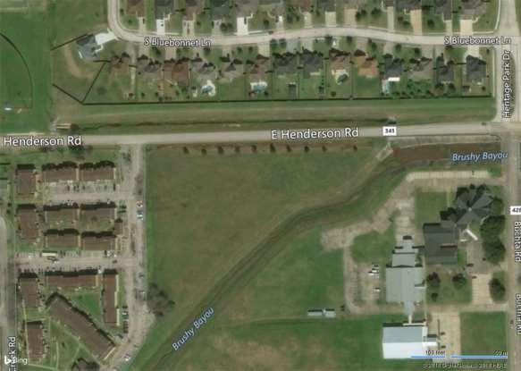
9 Subject Property Location
10 PLANNING AND ZONNG COMMISSION AGENDA ITEM Meeting Date: March 1, 2018 SUBJECT: Discussion and possible action regarding a Specific Use Permit to allow a game room at 2228 S. Velasco Street (SH 288 B). Consent item _x Discussion and possible action Discussion item Public Hearing REQUESTED BY: Ashley Business Ventures, Inc., by Clinton Rouse BCAD PROPERTY ID: EXECUTIVE SUMMARY: Location: The subject property is located along the west side of the South Velasco Street (SH 288 B). Surrounding Uses: Adjoining uses to the north and south, and across SHH 288 B are commercial and light industrial. Single-family residences are located west of the site. Proposed Use: The applicant proposes a game room. History: Most recently the subject site was used as a fencing business. Existing buildings on the site are primarily an office/warehouse, pole barn and other accessory. Considerations: 1. Code Compliance. The previous use of the property has been light industrial/warehousing. If the business was to change to retail with public assembly, the building would need to comply with all building and fire code requirements for such a use. 2. Off-Street Parking. If the use is changed to retail, the use would be subject to the off-street parking requirements of the retail use in terms of number of spaces and surfacing. It s not clear from aerial photos if adequate parking is available. 3. Plan of Operation. The SUP application indicates that Home Based Entertainment or Recreation is proposed. A detailed description of what that use would entail was not provided. 4. Economic Development. The subject property is not being used and sites near the southern entrance into the city along a major highway. The City would clearly benefit by the use of the property in a positive manner. 5. Adjoining Residential Uses. Single-family residences are located near the west property line of this site. The application does not specify which building the use would be conducted, hours of operation, or related information to allow staff to determine if the use would affect the residences. 6. Precedent. In the past, the City Council has granted similar applications for period of 1 or 2 years, subject to the conditions listed at the end of this report. Since neighbors are nearby, the hours of operation, lighting, noise, and signage may also need to be addressed, depending upon the Plan of Operation.
11 The primary concern of staff is that a substantial investment of capital may be required to bring the structure up to building and fire code requirements and parking requirements. Staff discussed those concerns with the applicant. The applicant indicated that would be willing to bring into conformance with all applicable code and parking requirements and would be willing to subject to a 2-year limitation on the grant of the SUP. After explaining the proposed business plan, staff asked the applicant to prepare a written Plan of Operation detailing how the business would operate. Staff also made the applicant made the applicant aware of the concerns of the neighbors and the fact that the neighbors had issues with the former manner in which the business on this site operated. Planning & Zoning Commission Action: The Commission will discuss and may make a recommendation to the City Council on this request. Staff Recommendation: Staff recommends that the Commission recommend that the City Council approve this request subject to the following conditions: 1. The applicant shall submit a detailed Plan of Operation describing how the proposed use would be operated. 2. Prior to the issuance of a Certificate of Occupancy, the building shall subject to compliance with all applicable building and fire codes and that adequate off-street parking spaces shall be provided, in accordance with the Zoning Ordinance. 3. The Amusement Redemption Machine Game Room will comply with all provisions of City of Angleton Code of Ordinances including but not limited Chapter 28 Zoning, Sec Specific Use Permits, and Chapter 21 Public Amusements, Art. V. Amusement Redemption Machine Game Room and all Brazoria County regulations; 4. Hours of Operation will be 8:00 a.m. to 2:00 a.m., Monday through Saturday; 5. Tinted windows are prohibited; 6. Records for each employee containing name, address, date of birth, state identification, social security number and job function will be kept current and on the premises at all times; 7. Records detailing each machine, name of manufacturer, serial number, type of machine, name of machine owner, receives profits from, and has registered their name with the Texas Comptroller; 8. The Game room will be open to inspection for violations of City of Angleton regulations at all times by City of Angleton Peace Officers, Fire Safety Officials, the Building Official, all other designated City of Angleton officials, and Brazoria County Peace Officers, and Brazoria County officials; 9. Revocation of the Specific Use Permit may occur at any time if one or more of the conditions set forth in this Ordinance have not been met or are violated; 10. Specific Use Permit is conditioned upon a valid lease-hold interest being held by the business granted the Specific Use Permit; and 11. The term of the granting of this SUP shall be temporary, expiring two years from date of the approval of this SUP is granted, to allow the applicant, Ashley Business Ventures, Inc., to demonstrate compliance with of the above cited terms and conditions of the SUP. Upon its two-year review, the Council may extend the approval of the SUP for an additional temporary term, revoke the SUP immediately, or after the one-year original SUP term lapses, or approve the SUP without any time limitation, subject to continued compliance with the conditions described above. Randy Anderson, Assistant City Manager March 1, 2018 Name Date

12 Historic Use of 2228 S. Velasco Street

13 Current Condition of 2228 S. Velasco Street
14 PLANNING AND ZONING COMMISSION AGENDA ITEM Meeting Date: March 1, 2018 SUBJECT: Discussion and possible action regarding the rezoning of two tracts of property known a Heritage Park Sections 1 and 2, containing acres of land in the T. S. Lee Survey, Abstract 318, Brazoria County, Texas from Planned Development (PD) and Agricultural (AG) to Single-Family Residential-7.2 (SF-7.2). Consent item _x Discussion and possible action Discussion item Public Hearing REQUESTED BY: Tyler Broom, Designated Agent for property owners EXECUTIVE SUMMARY: History: The process to rezone the subject property from PD and AG to SF-7.2 began in June 2017 and was completed in January The delay in completing the rezoning process was due to the fact that a required Public Hearing on the matter before City Council on July 18, 2017 was postponed due to the lack of a quorum. There was also confusion with the legal description to describe all of the acreage to be rezoned and annexed into the City in conjunction with Heritage Park Section 2. From the records available to staff in December 2017, it appeared that the City Council had completed the required Public Hearing on July 25, 2017 and only needed to take final action on the rezoning, which they did on January 23, 2018, rezoning this acreage SF-7.2. Additional review of the City Council minutes revealed that the required Public Hearing, in fact, was never completed. Comprehensive Plan: The proposed zoning is consistent with the recommendations of the Comprehensive Plan. Existing Land Use: The proposed zoning is consistent with the present use of the property and the previous intentions of the City Council and Commission to rezone this acreage. Planning and Zoning Commission Action: The Commission will discuss and may take action on this item. Staff Recommendation: Staff recommends a motion to recommend approval of the request for rezoning to SF-7.2. Randy Anderson, Assistant City Manager March 1, 2018 Name Date

15 Heritage Park Location / Zoning
16 PLANNING AND ZONING COMMISSION AGENDA ITEM Meeting Date: March 1, 2018 Public Hearing on a request to rezone a 4.99-acre tract located immediately east of Henderson Road Apartments and north and west of Brushy Bayou, from SF-7.2 (Single-Family Residential) to MFR-29 (Multi-Family Residential). Consent item _x Discussion and possible action Discussion item Public Hearing REQUESTED BY: Siva Palchuru, by Stephanie Devereux BCAD PROPERTY ID: EXECUTIVE SUMMARY: Location: The subject property is vacant and is located along the south side of East Henderson Road immediately east of the Henderson Road Apartment complex. Brushy Bayou adjoins the south and east property lines of the subject site. Surrounding Uses: Single-family residences are located to the north across East Henderson Road. The apartment complex owned by the applicant is located to the west. Brushy Bayou is located to the south and east. A church is located on the other side of Brushy Bayou. Proposed Use: The applicant proposes an addition to the Henderson Road Apartment complex. Comprehensive Plan: The proposed zoning would be consistent with the recommendation of the Comprehensive Plan. Considerations: Based on the shape and location of the property and the surrounding uses, the proposed zoning of the site would be consistent with generally accepted planning principles. Planning & Zoning Commission Action: The Commission will discuss and may take action on the item. Staff Recommendation: Staff recommends a motion to convene a Public Hearing. Randy Anderson, Assistant City Manager March 1, 2018 Name Date

17 Surrounding Zoning (Site Adjoins Green Shaded MFR-29 Tract)
18 Proposed Development Plan and Surrounding Zoning
19 PLANNING AND ZONING COMMISSION AGENDA ITEM Meeting Date: March 1, 2018 Discussion and possible a ction o n t h e F i n a l P l a t o f L a k e s i d e P a r k. Consent item _x Discussion and possible action Discussion item Public Hearing REQUESTED BY: Angleton Drainage District, by Josh McGinn, RPLS EXECUTIVE SUMMARY: The acre subject property is located on the westside of Anchor Road (CR 44) between SH 288 and Loop 274, and adjoins Heritage Oaks Section 3. The property owner is Angleton Drainage District, who will dedicate the property to the City of Angleton as Lakeside Park. ADD will maintain the drainage facilities on the plat and for that purpose has reserved two access easements for that purpose. The plat has been determined by the City Engineer to comply with all requirements of the Subdivision Ordinance and has been approved by ADD. For those reasons, staff recommends approval of the Final Plat of Lakeside Park. Planning and Zoning Commission Action: Staff recommends that the Commission recommend that the City Council approve the Final Plat of Lakeside Park, as submitted. Randy Anderson, Assistant City Manager March 1, 2018 Name Date
20 BRAZORIA COUNTY, TEXAS LAKESIDE PARK VICINITY MAP STATE OF TEXAS COUNTY OF BRAZORIA KNOW ALL MEN BY THESE PRESENTS THAT: I, DAVID SPOOR, CHAIRMAN OF ANGLETON DRAINAGE DISTRICT (A.D.D.), PARTIAL OWNER OF THE PROPERTY SUBDIVIDED IN THE FOREGOING REPLAT OF LAKESIDE PARK SUBDIVISION, DOES HEREBY MAKE SUBDIVISION OF SAID PROPERTY ACCORDING TO THE LINES, LOTS AND EASEMENTS SHOWN HEREON. LOT-1 (45.77 ACRES) IS HEREBY GIVEN TO THE CITY OF ANGLETON FOR THE PURPOSE PARKLAND DEVELOPMENT. LOT-2 (5.08 ACRES) WILL REMAIN OWNED BY THE A.D.D.. ALL ACCESS, DRAINAGE AND MAINTENANCE EASEMENTS SHOWN HEREON IN LOT-1 ARE ARE SPECIFICALLY DEDICATED FOR A.D.D.'S USE IN FLOOD CONTROL, BUT ARE ALSO DEDICATED TO THE PUBLIC FOR THEIR USE AS PARKLAND FOREVER. A.D.D. DESIGNATES SAID SUBDIVISION AS THE PLAT OF TWO LOTS, BEING A SUBDIVISION OF ACRES IN THE CITY OF ANGLETON, BRAZORIA COUNTY, TEXAS AND DO HEREBY BIND OURSELVES, OUR HEIRS AND ASSIGNS TO WARRANT AND DEFEND THE TITLE TO THE LAND SO DEDICATED ACRES CITY OF ANGLETON C.C.F.# , O.R.B.C.T. 10' ROAD EASEMENT VOLUME 228, PAGE 515, O.R.B.C.T. 10' B.L. TOP BANK ACRES ANGLETON DRAINAGE DISTRICT C.C.F.# , O.R.B.C.T. TOP BANK POINT OF BEGINNING MAP NOT TO SCALE LEGEND O.R.B.C.T. = OFFICIAL RECORDS OF BRAZORIA COUNTY, TEXAS C.C.F.# = COUNTY CLERKS FILE NUMBER R.O.W. = RIGHT-OF-WAY B.L. = BUILDING SETBACK LINE = SET 5/8-INCH IRON ROD WITH CAPPED STAMPED "BAKER & LAWSON" = FOUND 5/8-INCH IRON ROD WITNESS MY HAND THIS THE DAY OF, 20. DAVID SPOOR, CHAIRMAN LOT ACRES FORMER TRACT-56 FORMER TRACT-55 FORMER TRACT-53 FORMER TRACT-54 STATE OF TEXAS COUNTY OF BRAZORIA ~ BEFORE ME THE UNDERSIGNED AUTHORITY ON THIS DAY PERSONALLY APPEARED DAVID SPOOR, KNOWN TO ME TO BE THE PERSON WHOSE NAME IS SUBSCRIBED TO THE FOREGOING INSTRUMENT, AND ACKNOWLEDGED TO ME THAT THE SAME WAS THE ACTING CHAIRMAN FOR THE PURPOSES AND CONSIDERATION THEREIN EXPRESSED AND IN THE CAPACITY THEREIN STATED. 25' B.L. 15' B.L. SURVEYOR'S NOTES: SCALE : 1" = 150' GIVEN UNDER MY HAND AND SEAL OF OFFICE THIS THE DAY OF, 20 _. NOTARY PUBLIC IN AND FOR THE STATE OF TEXAS MY COMMISSION EXPIRES SUBDIVISION APPROVALS CITY PLANNING COMMISSION I CERTIFY THAT THE ABOVE AND FOREGOING LAKESIDE PARK SUBDIVISION, WAS APPROVED THIS THE DAY OF, 20. BY THE CITY PLANNING COMMISSION OF ANGLETON, TEXAS. CHAIRMAN WITNESS MY HAND THIS THE DAY OF, 20. CITY SECRETARY CITY COUNCIL I HEREBY CERTIFY THAT THE ABOVE AND FOREGOING FINAL REPLAT OF LAKESIDE PARK SUBDIVISION ADDITION TO THE CITY OF ANGLETON WAS APPROVED AND AS PARTIAL OWNER OF THE PROPERTY SUBDIVIDED IN THE FOREGOING REPLAT OF LAKESIDE PARK SUBDIVISION, DOES HEREBY MAKE SUBDIVISION OF SAID PROPERTY ACCORDING TO THE LINES, LOTS AND EASEMENTS SHOWN HEREON. LOT-1 (45.77 ACRES) IS HEREBY GIVEN TO THE CITY OF ANGLETON FOR THE PURPOSE PARKLAND DEVELOPMENT. LOT-2 (5.08 ACRES) WILL REMAIN OWNED BY THE A.D.D.. ALL ACCESS, DRAINAGE AND MAINTENANCE EASEMENTS SHOWN HEREON IN LOT-1 ARE ARE SPECIFICALLY DEDICATED FOR A.D.D.'S USE IN FLOOD CONTROL, BUT ARE ALSO DEDICATED TO THE PUBLIC FOR THEIR USE AS PARKLAND FOREVER. A.D.D. DESIGNATES SAID SUBDIVISION AS THE PLAT OF TWO LOTS, BEING A SUBDIVISION OF ACRES IN THE CITY OF ANGLETON, BRAZORIA COUNTY, TEXAS AND DO HEREBY BIND OURSELVES, OUR HEIRS AND ASSIGNS TO WARRANT AND DEFEND THE TITLE TO THE LAND SO DEDICATED. THIS THE DAY OF, 20. BY THE CITY COUNCIL OF THE CITY OF ANGLETON, TEXAS. MAYOR SAID ADDITION SHALL BE SUBJECT TO ALL THE REQUIREMENTS OF THE CODE OF ORDINANCES OF THE CITY OF ANGLETON, TEXAS. WITNESS MY HAND THIS THE DAY OF, ' B.L. FORMER TRACT-56 FORMER TRACT-52 LOT ACRES THE POSSIBLE EXISTENCE OF UNDERGROUND FACILITIES OR SUBSURFACE CONDITIONS OTHER THAN THOSE SHOWN MAY AFFECT THE USE AND DEVELOPMENT OF THE SUBJECT PROPERTY SHOWN HEREON. THE DOCUMENTS REFERRED TO HEREON, WHETHER THOSE OF PUBLIC RECORD OR OTHERWISE, WERE OBTAINED BY THE SURVEYOR AND/OR PROVIDED BY THE CLIENT. EXCEPT AS SPECIFICALLY STATED OR SHOWN ON THIS PLAT, THIS SURVEY DOES NOT PURPORT TO REFLECT ANY OF THE FOLLOWING WHICH MAY BE APPLICABLE TO THE SUBJECT REAL ESTATE: EASEMENTS, OTHER THAN POSSIBLE EASEMENTS WHICH WERE VISIBLE ON THE GROUND AT THE TIME OF MAKING THIS SURVEY; RESTRICTIVE COVENANTS, SUBDIVISION REGULATIONS, ZONING OR OTHER LAND-USE REGULATIONS, AND OTHER FACTS OTHER THAN THOSE WHICH AN ACCURATE AND CURRENT TITLE SEARCH MAY DISCLOSE. ALL BEARINGS AND DISTANCES ARE REFERENCED TO THE TEXAS COORDINATE SYSTEM, SOUTH CENTRAL ZONE, NAD-83, U.S. SURVEY FEET. FLOOD ZONE STATEMENT: ACCORDING TO THE FEDERAL EMERGENCY MANAGEMENT AGENCY FLOOD INSURANCE RATE MAP FOR BRAZORIA COUNTY, MAP NUMBER H, WITH EFFECTIVE DATE OF JUNE 05, 1989, AND A REVISION DATE OF OCTOBER 06, 2004,THE PROPERTY SURVEYED LIES FULLY WITHIN ZONE "X" (UNSHADED), AREAS DETERMINED TO BE OUTSIDE THE 500-YEAR FLOOD-PLAIN. WARNING: THIS FLOOD STATEMENT DOES NOT IMPLY THAT THE PROPERTY AND/OR STRUCTURES WILL BE FREE FROM FLOODING OR FLOOD DAMAGE, AND WILL NOT CREATE LIABILITY ON THE PART OF THE SURVEYOR. ALL OF THE PROPERTY SURVEYED LIES FULLY WITHIN THE CITY LIMITS OF THE CITY OF ANGLETON. 6. REFERENCE BENCHMARK: TXDOT ALUMINUM DISK LOCATED ON THE TOP OF THE CENTER OF HEADWALL AT THE NORTHWEST CORNER OF THE INTERSECTION OF COUNTY ROAD 341 (HENDERSON ROAD) AND THE FEEDER ROAD OF STATE HIGHWAY 288 SOUTHBOUND, HAVING A DATUM OF NAVD-88, U.S. SURVEY FEET, ELEVATION = 31.94' FIELD NOTES DESCRIPTION: CITY SECRETARY A ACRE TRACT OF LAND BEING THE COMBINATION OF THE REMAINDER OF TRACTS OF THE NEW YORK AND TEXAS LAND COMPANY SUBDIVISION AS PER THE PLAT RECORDED IN VOLUME 26, PAGE 140, IN THE OFFICIAL RECORDS OF BRAZORIA COUNTY, TEXAS (O.R.B.C.T.) AND BEING THE SAME PROPERTY CONVEYED TO ANGLETON DRAINAGE DISTRICT (A.D.D.) IN DEED RECORDED UNDER COUNTY CLERKS FILE NUMBER (C.C.F.#) , O.R.B.C.T., A 30-FOOT WIDE ABANDONED RIGHT-OF-WAY (R.O.W.) AND A 60-FOOT WIDE ABANDONED R.O.W. BOTH CONVEYED TO A.D.D. FROM THE CITY OF ANGLETON IN DEED RECORDED UNDER C.C.F.# , O.R.B.C.T. AND SITUATED IN THE J. DE J. VALDERAS SURVEY, ABSTRACT-380, BRAZORIA COUNTY, TEXAS, SAID ACRE TRACT BEING MORE PARTICULARLY DESCRIBED BY METES AND BOUNDS AS FOLLOWS: KNOWN BY ALL MEN THESE PRESENTS: THAT I, JOSHUA A. MCGINN, TEXAS REGISTERED PROFESSIONAL SURVEYOR NUMBER 6467, DO HEREBY CERTIFY THAT I PREPARED THIS PLAT FROM AN ACTUAL AND ACCURATE SURVEY OF THE LAND AND THAT THE CORNER MONUMENTS SHOWN THEREON SHALL BE PROPERLY PLACED UNDER MY PERSONAL SUPERVISION, IN ACCORDANCE WITH THE CODE OF REGULATIONS OF THE CITY OF ANGLETON, TEXAS. BEGINNING AT A 5/8-INCH IRON ROD WITH CAP STAMPED "BAKER & LAWSON" SET ON THE NORTH R.O.W. LINE OF A 60-FOOT WIDE UNIMPROVED ROAD PLATTED IN SAID VOLUME 26, PAGE 140, O.R.B.C.T. AT THE INTERSECTION OF THE EAST LINE OF SAID 60-FOOT ABANDONED R.O.W. MARKING THE SOUTHEAST CORNER OF THE HEREIN DESCRIBED TRACT; THENCE S 85 30' 06 W ALONG THE NORTH R.O.W. LINE OF SAID 60-FOOT WIDE UNIMPROVED ROAD, A DISTANCE OF 2, FEET TO A 5/8-INCH IRON ROD WITH CAP STAMPED BAKER & LAWSON SET ON THE EAST BOUNDARY LINE OF LOT-13, BLOCK-10 OF THE HERITAGE OAKS SUBDIVISION SECTION-3 AS PER THE PLAT RECORDED IN VOLUME 23, PAGES , O.R.B.C.T. FOR THE SOUTHWEST CORNER OF THE HEREIN DESCRIBED TRACT; ANGLETON DRAINAGE DISTRICT ACCEPTED THIS THE DAY OF, 20, BY THE ANGLETON DRAINAGE DISTRICT. JOSHUA A. MCGINN REGISTERED PROFESSIONAL LAND SURVEYOR NO DATE THENCE N 04 16' 39 W ALONG THE EAST BOUNDARY LINE OF SAID LOT-13 AND THE WEST LINE OF SAID 30-FOOT ABANDONED R.O.W., C.C.F.# , O.R.B.C.T., A DISTANCE OF FEET TO 5/8-INCH IRON ROD FOUND ON THE SOUTH R.O.W. LINE OF OAK RIDGE DRIVE MARKING THE NORTHEAST CORNER OF SAID LOT-13 AND AN ANGLE POINT IN THE WEST BOUNDARY LINE OF THE HEREIN DESCRIBED TRACT; THENCE S 74 32' 43" E ALONG THE SOUTH R.O.W. LINE OF OAK RIDGE DRIVE, A DISTANCE OF FEET TO A 5/8-INCH IRON ROD FOUND MARKING AN INTERIOR CORNER OF ON THE WEST BOUNDARY LINE OF THE HEREIN DESCRIBED TRACT; THENCE N 04 16' 39 W ALONG THE EAST BOUNDARY LINE OF SAID HERITAGE OAKS SUBDIVISION, SECTION-3, A DISTANCE OF FEET TO A 5/8-INCH IRON ROD FOUND MARKING THE SOUTHEAST CORNER OF THE PARK RESERVE A OF SAID HERITAGE OAKS SUBDIVISION SECTION-3 AND AN ANGLE POINT IN THE WEST BOUNDARY LINE OF THE HEREIN DESCRIBED TRACT; THENCE N 03 02' 12 E ALONG THE EAST BOUNDARY LINE OF SAID PARK RESERVE "A", A DISTANCE OF FEET TO A 5/8-INCH IRON ROD FOUND MARKING THE NORTHEAST CORNER OF SAID PARK RESERVE "A", AN ANGLE POINT IN THE WEST BOUNDARY LINE OF THE HEREIN DESCRIBED TRACT; THENCE N 85 36' 07 E A DISTANCE OF FEET TO A 5/8-INCH IRON ROD FOUND MARKING A COMMON CORNER BETWEEN THE EAST R.O.W. OF ENCHANTED OAKS DRIVE AND THE WEST BOUNDARY LINE OF THE HEREIN DESCRIBED TRACT; THENCE N 04 16' 39 W ALONG THE EAST R.O.W. LINE OF ENCHANTED OAKS DRIVE, A DISTANCE OF FEET TO A 5/8-INCH IRON ROD FOUND MARKING AN ANGLE POINT IN THE WEST BOUNDARY LINE OF THE HEREIN DESCRIBED TRACT; THENCE N 26 06' 20 W ALONG THE EAST R.O.W. LINE OF ENCHANTED OAKS DRIVE, A DISTANCE OF FEET TO A 5/8-INCH IRON ROD FOUND MARKING AN ANGLE POINT IN THE WEST BOUNDARY LINE OF THE HEREIN DESCRIBED TRACT; THENCE N 04 16' 39 W ALONG THE EAST R.O.W. LINE OF ENCHANTED OAKS DRIVE, A DISTANCE OF FEET TO A 5/8-INCH IRON ROD WITH CAP STAMPED BAKER & LAWSON SET ON THE EAST LINE OF SAID 60-FOOT ABANDONED R.O.W. FOR THE NORTH CORNER OF THE HEREIN DESCRIBED TRACT; THENCE S 47 14' 53 E ALONG THE EAST LINE OF SAID 60-FOOT ABANDONED R.O.W., A DISTANCE OF 2, FEET TO THE POINT OF BEGINNING OF THE HEREIN DESCRIBED TRACT CONTAINING ACRES (OR 2,215, SQUARE FEET) OF LAND. THE BOARD OF SUPERVISORS OF THE ANGLETON DRAINAGE DISTRICT DOES NOT WARRANT, REPRESENT OR GUARANTEE: 1. THAT DRAINAGE FACILITIES OUTSIDE THE BOUNDARIES OF THE SUBDIVISION PLAT ARE AVAILABLE TO RECEIVE RUNOFF FROM THE FACILITIES DESCRIBED IN THIS PLAT. 2. THAT DRAINAGE FACILITIES DESCRIBED IN THIS PLAT ARE ADEQUATE FOR RAINFALL IN EXCESS OF ANGLETON DRAINAGE DISTRICT MINIMUM REQUIREMENTS. 3. THAT BUILDING ELEVATION REQUIREMENTS HAVE BEEN DETERMINED BY THE ANGLETON DRAINAGE DISTRICT. 4. THAT THE DISTRICT ASSUMES ANY RESPONSIBILITY FOR CONSTRUCTION, OPERATION OR MAINTENANCE OF SUBDIVISION DRAINAGE FACILITIES. THE DISTRICT'S REVIEW IS BASED SOLELY ON THE DOCUMENTATION SUBMITTED FOR REVIEW, AND ON THE RELIANCE ON THE REPORT SUBMITTED BY THE TEXAS REGISTERED PROFESSIONAL ENGINEER. THE DISTRICT'S REVIEW IS NOT INTENDED NOR WILL SERVE AS A SUBSTITUTION OF THE OVERALL RESPONSIBILITY AND/OR DECISION MAKING POWER OF THE PARTY SUBMITTING THE PLAT OR PLAN HEREIN, THEIR OR ITS PRINCIPALS OR AGENTS. CHAIRMAN, BOARD OF SUPERVISORS BOARD MEMBER BOARD MEMBER SCALE: DATE: PROJECT NO.: " = 150' REVISION NO.: OWNERS: ANGLETON DRAINAGE DISTRICT PO BOX 2469, ANGLETON, TX AND CITY OF ANGLETON 121 S. VELASCO, ANGLETON, TEXAS EAST CEDAR ST. ANGLETON, TEXAS OFFICE: (979) TBPLS No REVISION DESCRIPTION: DRAWN BY: CHECKED BY: DRAWING NO.: BT RC 1 OF 1 FINAL PLAT OF A 2-LOT SUBDIVISION A RE-PLAT OF THE REMAINDER OF LOTS OF THE NEW YORK & TEXAS LAND COMPANY SUBDIVISION BEING A TOTAL OF ACRES OF LAND OUT OF THE J. DE J. VALDERAS SURVEY, A-380, BRAZORIA COUNTY, TEXAS CITY OF ANGLETON
21 CITY OF ANGLETON, TEXAS PLANNING & ZONING COMMISSION 12 p.m., Wednesday, July 12, 2017 Located at 120 S. Chenango in the Council Chambers, Angleton, Texas Declaration of Quorum and Call to Order. All Commissioners were present, so a quorum was declared. 2. Discussion and Possible Action on approving the June 7, 2017 meeting minutes. Motion to approve by Vice Chairman Munson; Second by Commissioner Bieri. Motion carries 6 for; 0 against. 3. Discussion and Possible Action regarding appointment to the Planning & Zoning Commission. A. Belinda Gaines B. Lisa Gingrich C. Martin Stulberg The Commission questioned the candidates and the qualifications of each. After careful consideration and deliberation, the Commission was ready for a motion. Motion to appoint Martin Stulberg by Commissioner Spoor; Second by Commissioner Hernandez. Motion carries 6 for; 0 against. 4. Public Hearing on a request to rezone two separate portions of a tract of land containing acres of land situated in the T. S. Lee Survey, Abstract 318, Brazoria County, Texas; the southerly portion of the acres (which is currently in the city limits) from PD Planned Development District to SF-7.2 Single-Family Residential-7.2 District and the northerly portion of the acres (being annexed into the city) from AG Agricultural District to SF-7.2 Single-Family Residential-7.2 District. Motion to open a public hearing by Commissioner Spoor; Second by Commissioner Townsend. Motion carries 6 for; 0 against. No one spoke in favor of, or opposition to, the rezoning request.
22 Motion to approve by Vice Chairman Munson; Second by Commissioner Bieri. Motion carries 6 for; 0 against. 5. Discussion and Possible Action on a request to rezone two separate portions of a tract of land containing acres of land situated in the T. S. Lee Survey, Abstract 318, Brazoria County, Texas; the southerly portion of the acres (which is currently in the city limits) from PD Planned Development District to SF-7.2 Single-Family Residential-7.2 District and the northerly portion of the acres (being annexed into the city) from AG Agricultural District to SF- 7.2 Single-Family Residential-7.2 District. No one spoke in favor of, or opposition to, the rezoning request. Motion to recommend approval by Commissioner Townsend; Second by Commissioner Bieri. Motion carries 6 for; 0 against. 6. Discussion and Possible Action on the Heritage Park Subdivision, Section Two Preliminary Plat, a subdivision containing acres in the T.S. Lee Survey, Abstract 318, Tract 42, Lots 20-21A, Oliver & Barrows Subdivision, Brazoria County, Texas, said acre tract being a partial replat of Detention Reserve A and a replat of Greenbelt Reserve B of the Heritage Park Subdivision, Section One. No one spoke in favor of, or opposition to, the rezoning request. The engineer was present if the Commission had any questions. Motion to recommend approval by Vice Chairman Munson; Second by Commissioner Bieri. Motion carries 6 for; 0 against. 7. Discussion and Possible Action on the Heritage Park Subdivision, Section Two Final Plat, a subdivision containing acres in the T.S. Lee Survey, Abstract 318, Tract 42, Lots 20-21A, Oliver & Barrows Subdivision, Brazoria County, Texas, said acre tract being a partial replat of Detention Reserve A and a replat of Greenbelt Reserve B of the Heritage Park Subdivision, Section One. No one spoke in favor of, or opposition to, the rezoning request. The engineer was present if the Commission had any questions. Motion to recommend approval by Commissioner Bieri; Second by Vice Chairman Munson. Motion carries 6 for; 0 against. 8. Adjourn. Motion to adjourn by Commissioner Spoor; Second by Commissioner Bieri.

23 Motion carries 6 for; 0 against. Meeting adjourned at 12:35 p.m. CERTIFICATION Bill Garwood, Chairman Dana Alsobrook, City Secretary
24 Minutes for 12/06/17 Planning & Zoning Commission Meeting CITY OF ANGLETON, TEXAS PUBLIC NOTICE OF A PLANNING & ZONING COMMISSION MEETING WEDNESDAY, NOVEMBER 01, 12:00 P.M. 120 S. VELASCO STREET ANGLETON, TEXAS Declaration of a quorum and call to order at 12:00 p.m. 2. Public Hearing on a request to consider a Specific Use Permit to allow a Game Room with a base zoning of Light Industrial (LI) at 1501 South Velasco Street. Commissioner Townsend recused himself from the item. Motion by Commissioner Munson to open the Public Hearing; Second by Commissioner Bieri Motion carries 4 for; 0 against; 2 absent (Stulberry and Hernandez); 1 recused (Townsend) Corinna Williams, the applicant, described the proposed use and spoke in favor of that use. No additional persons spoke in favor of, or opposition to, the item. Motion by Commissioner Munson to close the Public Hearing; Second by Commissioner Bieri Motion carries 4 for; 0 against; 2 absent (Stulberry and Hernandez); 1 recused (Townsend) 3. Discussion and Possible Action on a request for a Special Use Permit to allow a Massage Therapy Business with a base zoning of Commercial-Office Retail (C/OR) at 1100 E. Mulberry Suite B. Randy Anderson reminded the Commission that it conducted a Public Hearing on this item on November 1, 2017, and that no persons spoke in favor of, or opposition to, the request. The Commission tabled the item on November 1, 2017 because the applicant wasn t able to attend the meeting. Staff recommended approval of the request, subject to the conditions set out in the staff report, which mitigated the need for a temporary SUP because the conditions were linked to compliance with TDLR laws. 1
25 The applicant, Laurie Hamilton, described the proposed use and answered Commissioner question about the proposed operation. Motion by Commissioner Bieri to approve the SUP application subject to the conditions escribed in the staff report; Second by Commissioner Munson Motion carries 5 for; 0 against; 2 absent (Stulberry and Hernandez) 4. Discussion and possible action for a Special Use Permit to allow a Pet Boarding & Grooming facility with a base zoning of Commercial-General (C-G) at 500 W. Mulberry Suite B. Randy Anderson reminded the Commission that a Public Hearing was conducted on this item on November 1, 2017 and that the item was tabled to allow the applicant to submit a Plan of Operation. Since staff had not received a Plan of Operation and no one was present to represent the request, staff recommended denial of the request. Motion by Commissioner Townsend to deny the SUP application; Second by Commissioner Spoor Motion carries 5 for; 0 against; 2 absent (Stulberry and Hernandez) 5. Discussion and Possible Action regarding a Specific Use Permit to allow a Game Room with a base zoning of Light Industrial (LI) at 1501 South Velasco Street. Randy Anderson described the history of game rooms located at this location and recent action of the City Council to deny the renewal of an SUP at this same location for the same use for the failure of the previous operator to follow all City and State of Texas laws governing game room operations. Corinna Williams described the proposed use and indicated that she was not affiliated with the former persons who conducted the business, and responded to many questions by the Commission to distinguish her proposed operation with the previous operation. told the Commissioners that the applicant reminded the Commission that a Public Hearing was conducted on this item on November 1, 2017 and that the item was tabled to allow the applicant to submit a Plan of Operation for the proposed use. When staff contacted the owner to instruct the applicant about the issues expressed by the Commission, the owner indicated that he would convey that information to the applicant but that he thought the applicant would seek a different location for this use. Since no person was present to present the request or provide a Plan of Operation, staff recommended that the Commission deny the request. Motion by Commissioner Munson to deny the proposed SUP; Second by Commissioner Bieri Motion carries 4 for; 0 against; 2 absent (Stulberry and Hernandez); 1 recused (Townsend) After the vote, the Commission advised Ms. Williams to prepare a Plan of operation prior to the City Council meeting to assist in obtaining a favorable outcome from City Council. 2
26 6. Discussion and possible action regarding the approval of Planning and Zoning Commission Minutes from October 4, 2017 and November 6, 2017 Commission meetings. Motion by Commissioner Spoor to approve, as submitted; Second by Commissioner Townsend Motion carries 5 for; 0 against; 2 absent (Stulberry and Hernandez) 7. Discussion regarding the rewriting of the Comprehensive Plan and the 2018 Planning Work Plan. Randy Anderson described the upcoming planning activities that staff and Commission would be engaged in during the next 1 to 2 years. The existing Comprehensive Plan needs to be updated, so staff will plan to engage as many community stakeholders as possible to engage in the process and to participate to develop public consensus the public. Because the Comprehensive Plan would form the foundation for most of the planning actions that need to be taken by the City, the City was considering using a consultant to lead the Comprehensive Plan process. 8. Adjourn. Chairman Garwood acknowledged that the proposed process sounded familiar with what the City completed when the existing plan was developed. He, and other Commissioners, mentioned that developers are beginning to consider Angleton and that the City need to have standards and guidelines ready. Chairman Garwood also indicated that the Commission should be involved in the CIP process. Staff concurred. The Commissioners stated that they looked forward to engaging in all these procedures with staff. Motion by Commissioner Munson to adjourn; Second by Commissioner Spoor. Motion carries 5 for; 0 against; 2 absent (Stulberry and Hernandez) Adjourned at 12:46 p.m. CERTIFICATION Bill Garwood, Chairman Dana Alsobrook, City Secretary 3
27 Minutes for 2/01/18 Planning & Zoning Commission Meeting CITY OF ANGLETON, TEXAS PUBLIC NOTICE OF A PLANNING & ZONING COMMISSION MEETING THURSDAY, FEBRUARY 1, 12:00 P.M. 120 S. VELASCO STREET ANGLETON, TEXAS Declaration of a quorum and call to order at 12:00 p.m., with all members present. 2. Recognition of 17+ years of service on the Planning and Zoning Commission by Mrs. Dorothy Hernandez. Commissioner Garwood and the rest of the Commission thanks Mrs. Hernandez for 17+ years of service to the City of Angleton. Randy Anderson presented Mrs. Hernandez with a plaque commemorating her service and expressed the thanks of the City Council. 3. Discussion and possible action regarding an ordinance amending the Subdivision Ordinance to codify amendments adopted by the City in 2007, 2008, and 2016; adopt design guidelines for public improvements; create a Development Permit fee; and to ensure consistency with state law and improve ordinance functionality. Randy Anderson provided an overview of the proposed amendments to the Subdivision Ordinance and the need to codify five ordinances that were adopted by the City Council but that were not codified into the ordinance. Staff indicated that the reference to the Streambank Design Guidelines should be approved, but that the remainder of the ordinance should be considered as presented. Motion by Commissioner Bieri to approve the Amended Subdivision Ordinance without the reference to the Streambank Design Guidelines; Second by Commissioner Townsend Motion carries 6 for; 0 against. 4. Discussion and direction to City Council regarding existing City of Angleton Nuisance Laws and the possible extension of Nuisance Law enforcement outside of City Limits. 1
28 Randy Anderson provided an overview the existing nuisance laws of the City and the need to amend them extend the powers of the City 5,000 feet outside of the City Limits and to address additional nuisances inside and outside of the City Limits. Staff discussed the Schertz, TX Nuisance Ordinance as an example for the direction that the City of Angleton. The Planning and Zoning Commission, by unanimous consent, recommends that the City Council authorize the preparation of a Nuisance Ordinance to more effectively regulate nuisance issues with the City, and within 5,000 feet of the City Limits. 5. Discussion and possible recommendation(s) to City Council regarding the appointment of a new Commission to fill the remainder of the term of Mrs. Dorothy Hernandez. Randy Anderson indicated that it was customary for the Commission to recommend to the City Council the names of persons who may be willing to serve on the Planning and Zoning Commission when a vacancy occurs. Staff has posted such notice and received an application from Sandra Miller. After discussion, the Commission directed staff to contact Belinda Gaines and Lisa Gingrich, who were applicants for the Commission in 2017 when a vacancy occurred to determine if they were still interest in serving. The Commission did not make a formal recommendation of an individual, but by group consent requested that staff provide Council the names of Sandra Miller, Belinda Gaines, and Lisa Gingrich as potential candidates to complete the unexpired term of Mrs. Hernandez. 6. Discussion and possible action regarding the approval of Planning and Zoning Commission Minutes from December 6, 2017 meetings. 7. Adjourn. This item was tabled. Motion by Commissioner Spoor to adjourn; Second by Commissioner Stulberry. Motion carries 6 for; 0 against. Adjourned at 12:42 p.m. CERTIFICATION Bill Garwood, Chairman Dana Alsobrook, City Secretary 2
Honorable Mayor Bill Agan and members of the Richland Hills City Council. Final Plat Richland Hills, Lots 1 & 2, Block 1 Brumlow Addition
 2B - 1 Memorandum To: From: Date: Subject: Honorable Mayor Bill Agan and members of the Richland Hills City Council Jason Moore, Assistant City Manager January 17, 2017 Final Plat Richland Hills, Lots
RULES, REGULATIONS AND REQUIREMENTS RELATING TO THE APPROVAL AND ACCEPTANCE OF IMPROVEMENTS IN SUBDIVISIONS OR RE-SUBDIVISIONS
 GALVESTON COUNTY RULES, REGULATIONS AND REQUIREMENTS RELATING TO THE APPROVAL AND ACCEPTANCE OF IMPROVEMENTS IN SUBDIVISIONS OR RE-SUBDIVISIONS GALVESTON COUNTY ENGINEERING DEPARTMENT MARCH 3, 1997 Amendment
Preliminary Plat/Final Plat Application
 Melissa Municipal Center 3411 Barker Avenue Melissa, Texas 75454 Phone: (972) 838-2036 Applicant: Date: Address: Phone: Contact: Fax: E-mail: Propose Addition Name: Acres: Existing Zoning: Propose Zoning:
Planning. the propertyy. Texas Local. Government. Code. size of 2,0000 RSF-2-PUD. Road within the Wharf at a. Citizen. 0 Letter of. 1.
 Planning & Zoning Commissionn Replat Phase I of the Wharf at Clear Lake, Dock 18, Slips 1 and 2 Planning & Development Department February 15, 20166 Request Replat approximately 0.0209 acres of a previouslyy
LOCATION MAP SHEET 1 OF 10
 OWNER: ADDRESS: LOCATION MAP CENTURY LAND HOLDINGS II, LLC 6500 RIVER PLACE BLVD. BUILDING 2, SUITE 200 AUSTIN, TX 78730 OWNER: CITY OF LEANDER ADDRESS: P.O. BOX 319 LEANDER, TX 78646 ACREAGE: LOTS ACREAGE:
VACATING PLATS. The following documents are provided as required by the City of Conroe for use in the above titled platting submittals:
 Public Works - Engineering Division CITY OF CONROE VACATING PLATS The following documents are provided as required by the for use in the above titled platting submittals: Submittal Questionnaire (1-page).
OWNERS ACKNOWLEDGMENT
 OWNERS ACKNOWLEDGMENT STATE OF TEXAS COUNTY OF GALVESTON/HARRIS I (or we), (name of owner or owners) acting by and through (name and title of officer) being officers of (name of company or corporation),
PLANNING COMMISSION SUBDIVISION PLAT APPLICATION
 PLANNING COMMISSION SUBDIVISION PLAT APPLICATION Economic Development Department 3468 North Fulton Avenue Hapeville, Georgia 30354 Phone - 404.669.8269 Fax 404.669.3302 Rev. 09/23/16 1 The following information
MINOR PLAT. The following documents are provided as required by the City of Conroe for use in the above titled platting submittals:
 Public Works - Engineering Division CITY OF CONROE MINOR PLAT The following documents are provided as required by the City of Conroe for use in the above titled platting submittals: Submittal Questionnaire
SUBDIVISION APPLICATION
 SUBDIVISION APPLICATION Preliminary Plat Minor Plat Final Plat Amended Plat Applicant Name: Owner (if different from applicant) Name: Company: Company: Address: Address: City, State, Zip City, State, Zip
Planning. Preliminary. .70 acres into. tract of land. an unplatted. Edgar Barlow. 1. Proposed 2. Aerial Map. Subdivision
 Preliminary / Final Plat Glenmont, Section Two Planning & Zoning Commissionn Planning & Development Department May 19, 20144 Request Applicant Owner Zoning Location Attachments Subdivide approximately.70
A Preliminary Plat is required in addition to a Final Plat or Replat if any of the following apply:
 DO YOU NEED A PLAT? City of Grapevine, Texas PLATTING INFORMATION Updated July 22, 2014 Public Works Department Engineering Division 200 South Main Street Grapevine, Texas 76051 Tele: 817.410.3136 Fax:
Memorandum September 13, 2018
 Memorandum September 13, 2018 TO: FROM: Planning and Zoning Commission Julie Couch, Town Manager Israel Roberts, AICP Planning Manager SUBJECT: FINAL PLAT FOR THE EBERSOHL ADDITION BACKGROUND: This is
Subdivision Plat Signature Block Templates
 Subdivision Plat Signature Block Templates Please refer to the Subdivision Plat Checklist to determine which signature blocks are required for the plat you are preparing. All text must be at least 10 pt
Applying for a Conditional Use Permit in San Juan County
 Applying for a Conditional Use Permit in San Juan County The term "conditional use permit" refers to a land use which would not be permitted under normal regulations of a zoning district, however, the
SUBDIVISION APPLICATION
 SUBDIVISION APPLICATION City of Horn Lake Planning Department 3101 Goodman Road, W Horn Lake, MS 38637 662-342-3559 Fax: 662-342-3485 Applications due the 1st working day of the month. Submit application
CITY OF DECATUR, TEXAS
 Final Plat or Amending Plat / Replat Checklist A submittal of a complete application will facilitate a timely review. Failure of the applicant to provide required information or obtain a waiver from the
AGENDA PLANNING AND ZONING COMMISSION DECEMBER 5, Council Chambers 151 West Church Street Lewisville, Texas 6:30 P.M.
 AGENDA PLANNING AND ZONING COMMISSION DECEMBER 5, 2017 Council Chambers 151 West Church Street Lewisville, Texas 6:30 P.M. 1. CALL TO ORDER AND ANNOUNCE THAT A QUORUM IS PRESENT. 2. APPROVE MINUTES OF
ADMINISTRATIVE HEARING STAFF REPORT Country Club Acres Second Amended Subdivision Amendment PLNSUB E Parkway Avenue December 12, 2013
 ADMINISTRATIVE HEARING STAFF REPORT Country Club Acres Second Amended Subdivision Amendment PLNSUB2013-00925 2167 E Parkway Avenue December 12, 2013 Planning Division Department of Community & Economic
FINAL PLAT GUIDE TO SUBDIVIDING PROPERTY. Background
 FINAL PLAT GUIDE TO SUBDIVIDING PROPERTY Background A final plat is the second step in the process of subdividing land into separate parcels for future sale or lease. Once a preliminary plat has been approved
City of Shenandoah Development Package
 Upon completion return application to Development@shenandoahtx.us City of Shenandoah Development Package Documentation includes the following: Fee Schedule Platting Development Check List & Outline Development
LOCATION MAP: AERIAL PHOTOGRAPH, 2015:
 LOCATION MAP: AERIAL PHOTOGRAPH, 2015: ORDINANCE NO. AN ORDINANCE OF THE CITY OF BRYAN, TEXAS, AMENDING CHAPTER 130, ZONING, OF THE CITY OF BRYAN CODE OF ORDINANCES, BY CHANGING THE ZONING CLASSIFICATION
ACTION FORM BRYAN CITY COUNCIL
 ACTION FORM BRYAN CITY COUNCIL DATE OF COUNCIL MEETING: July 8, 2014 DATE SUBMITTED: June 17, 2014 DEPARTMENT OF ORIGIN: Development Services SUBMITTED BY: Maggie Dalton MEETING TYPE: CLASSIFICATION: ORDINANCE:
SUBDIVISION APPLICATION: RECOMBINATION PLAT or EXEMPT PLAT
 SUBDIVISION APPLICATION: RECOMBINATION PLAT or EXEMPT PLAT Pursuant to Article 7, Section 155.706 of the Unified Development Code, an owner of land within the jurisdiction of the Town (or a duly authorized
AGENDA HAYDEN PLANNING COMMISSION
 AGENDA HAYDEN PLANNING COMMISSION THURSDAY, DECEMBER 14, 2017 7:00 P.M. HAYDEN TOWN HALL 178 WEST JEFFERSON AVENUE REGULAR MEETING 1. CALL TO ORDER, MOMENT OF SILENCE & PLEDGE OF ALLEGIANCE 2. ROLL CALL
INFORMATION & PROCEDURES FOR CHANGE OF ZONING REQUESTS AND CONDITIONAL USE PERMITS
 INFORMATION & PROCEDURES FOR CHANGE OF ZONING REQUESTS AND CONDITIONAL USE PERMITS The applicant is strongly encouraged to attend a pre-application meeting for the project prior to submittal of a zoning
REQUEST FOR SPECIAL EXCEPTION FOR MANUFACTURED HOMES IN THE AR-1 & R-5 DISTRICT APPLICATION NO.
 REQUEST FOR SPECIAL EXCEPTION FOR MANUFACTURED HOMES IN THE AR-1 & R-5 DISTRICT APPLICATION NO. AGENT/DEVELOPER INFORMATION (If not owner) Name: Address: City: PROPERTY OWNER INFORMATION Name: Address:
Subdivision Plat Signature Block Templates
 Subdivision Plat Signature Block Templates Please refer to the Subdivision Plat Checklist to determine which signature blocks are required for the plat you are preparing. All text must be at least 10 pt
STANDARD LANGUAGE FORMAT GUIDE PLANNING SERVICES DIVISION
 A. OWNERSHIP CERTIFICATE The purpose of the ownership certificate is to identify the owner and provide the Volume and Page of Deed Records, verifying the ownership. When the property owner is a corporation,
A Final Plat will be reviewed concurrently with any other development review application(s) that is required.
 that is required.") RELATED FACTS TO KNOW: Adams County Recording Requirements, Annexation, Common Wall Subdivision, Development Plan (PUD Development Permit), Fees, Helpful Contact Information, Lot Line Adjustment, Neighborhood
RELATED FACTS TO KNOW: Adams County Recording Requirements, Annexation, Common Wall Subdivision, Development Plan (PUD Development Permit), Fees, Helpful Contact Information, Lot Line Adjustment, Neighborhood
PLANNING DIRECTOR. Approved by the Planning Director on this day of, A.D. 20. day of, A.D. 20. Approved by the Fire Chief on this
 Located in a portion of the West Half of Section 19, Township 5 South, Range 1 East, Salt Lake Base and Meridian. SURVEYOR'S CERTIFICATE I, the undersigned surveyor, do hereby certify that I am a registered
PLANNING COMMISSION REPORT Non-Public Hearing Item
 PC Staff Report 09/21/2015 Item No. 2B - 1 PLANNING COMMISSION REPORT Non-Public Hearing Item PC Staff Report 09/212015 ITEM NO. 2B: FINAL PLAT FOR MORGAN ADDITION; 800 MONTEREY WAY (MKM) : Consider a
AMENDING PLAT REQUIREMENTS Revised
 City of University Park AMENDING PLAT REQUIREMENTS Revised 9-3-2014 1. The amending plat is prepared with the appropriate certificates printed on the document and three (3) 24 x 36 paper copies are submitted
STANDARDS GOVERNING CONVEYANCES OF REAL PROPERTY IN DARKE COUNTY, OHIO
 STANDARDS GOVERNING CONVEYANCES OF REAL PROPERTY IN DARKE COUNTY, OHIO As directed by Section 319.203 of the Ohio Revised Code which states The County Auditor and the County Engineer shall adopt standards
QUITCLAIM DEED CR 202 THE STATE OF TEXAS KNOW ALL MEN BY THESE PRESENTS: COUNTY OF WILLIAMSON
 QUITCLAIM DEED CR 202 THE STATE OF TEXAS KNOW ALL MEN BY THESE PRESENTS: COUNTY OF WILLIAMSON That WILLIAMSON COUNTY, TEXAS, hereinafter referred to as Grantor, whether one or more, for and in consideration
AMENDING PLAT REQUIREMENTS Revised
 City of University Park AMENDING PLAT REQUIREMENTS Revised 10-2016 1. The amending plat is prepared with the appropriate certificates printed on the document and three (3) 24 x 36 paper copies are submitted
VICINITY MAP/AERIAL MAP SITE
 VICINITY MAP/AERIAL MAP SITE N ZONING MAP PA 9 PA 5 SITE Solterra West ODP PA 7 N , DATE, 2013, TIME, COUNTY OF JEFFERSON, STATE OF COLORADO, $ DEDICATION CERTIFICATE THE UNDERSIGNED, BEING THE OWNER(S)
REPLAT REQUIREMENTS Revised
 City of University Park REPLAT REQUIREMENTS Revised 02-2016 1. The replat is prepared with the appropriate certificates printed on the document and three (3) 24 x 36 paper copies are submitted with a completed
SPECIAL SERVICE AREA DISCLOSURE
 SPECIAL SERVICE AREA DISCLOSURE All lots within this subdivision are included within the County of Will Special Service Area Number and are subject to an annual tax levy in accordance with the provisions
City of Melissa, Texas Plat Dedication Language
 City of Melissa, Texas Plat Dedication Language [INCLUDE THE FOLLOWING DEDICATION LANGUAGE FOR INDIVIDUALS (MODIFY APPROPRIATELY TO REFLECT EXACTLY AS SHOWN ON PROPERTY DEED)]: NOW THEREFORE, KNOW ALL
Synergy Park Addition (Companion to item 3)
") Synergy Park Addition (Companion to item 3) Attachments: 1. Locator 2. Replat staff report 3. Replat W P G r es rg eo e s Bu hh wy Lot 6A 4.02-acres Lot 4C 13.02-acres Fran k Lots 4C and 6A, Block A Synergy
Synergy Park Addition (Companion to item 3) Attachments: 1. Locator 2. Replat staff report 3. Replat W P G r es rg eo e s Bu hh wy Lot 6A 4.02-acres Lot 4C 13.02-acres Fran k Lots 4C and 6A, Block A Synergy
ZONING BOARD OF ADJUSTMENTS (ZBOA) MEETING AGENDA
 MEETING AGENDA") ZONING BOARD OF ADJUSTMENTS (ZBOA) MEETING AGENDA Notice is hereby given of a Regular Meeting of the La Porte Zoning Board of Adjustments to be held on Thursday, April 27, 2017 at 6:00 p.m. at City Hall
ZONING BOARD OF ADJUSTMENTS (ZBOA) MEETING AGENDA Notice is hereby given of a Regular Meeting of the La Porte Zoning Board of Adjustments to be held on Thursday, April 27, 2017 at 6:00 p.m. at City Hall
TOWN OF EASTCHESTER BUILDING AND PLANNING DEPARTMENT PLANNING BOARD APPLICATION PACKAGE SUBDIVISIONS
 TOWN OF EASTCHESTER BUILDING AND PLANNING DEPARTMENT 40 Mill Road (914) 771-3317 building@eastchester.org Eastchester, NY 10709 (914) 771-3322 Fax www.eastchester.org TABLE OF CONTENTS PLANNING BOARD APPLICATION
APPLICATION FOR FINAL PLAT APPROVAL
 APPLICATION FOR FINAL PLAT APPROVAL Section 1. General. The undersigned Applicant (Applicant is synonymous with owner) makes this Application for Final Plat Approval in accordance with Chapter 21, Port
City of Grand Forks Staff Report
 City of Grand Forks Staff Report Planning and Zoning Commission March 6, 2019 City Council March 18, 2019 Agenda Item: 4-1 (Preliminary) Preliminary approval of the plat of University Place First Resubdivision
City of Lakewood Plat Specifications
 City of Lakewood Plat Specifications Revised 12/15/2015 Plat Checklist.1 Notes, Certifications and Acknowledgements..5 Electronic Submittal Information... 20 Sheet Layout.21 A Professional Land Surveyor,
APPENDIX C: PLAT SPECIFICATIONS AND CERTIFICATES
 APPENDIX C: PLAT SPECIFICATIONS AND CERTIFICATES A. Drawing. All plats for recording must be submitted on photographically reproducible and dimensionally stable polyester sheets such as Mylar, Cronar or
MASTER SUBDIVISION FINAL PLAT APPLICATION Town of Apex, North Carolina
 MASTER SUBDIVISION FINAL PLAT APPLICATION Town of Apex, North Carolina This document is a public record under the North Carolina Public Records Act and may be published to the Town s website or disclosed
July 18, 2017 Planning & Zoning Meeting 6:30 p.m.
 July 18, 2017 Planning & Zoning Meeting 6:30 p.m. Date: July 18, 2017 PLANNING AND ZONING MEETING ATTENDANCE LIST Commissioners Position Present Absent R.G. Reeder Bill Bonham Greg Smith Leslie Boudwin
MINOR SUBDIVISION FINAL PLAT APPLICATION Town of Apex, North Carolina
 MINOR SUBDIVISION FINAL PLAT APPLICATION Town of Apex, North Carolina This document is a public record under the North Carolina Public Records Act and may be published on the Town s website or disclosed
SUBMITTAL REQUIREMENTS: The number indicates the number of copies for submittal (if applicable).
.") Office Use Only Preliminary Long Plat Long Subdivision Applicant Checklist PLANNING, COMMUNITY, & ECONOMIC DEVELOPMENT DEPARTMENT PRELIMINARY LONG PLAT LONG SUBDIVISION CHECKLIST Mailing Address: P.O.
Office Use Only Preliminary Long Plat Long Subdivision Applicant Checklist PLANNING, COMMUNITY, & ECONOMIC DEVELOPMENT DEPARTMENT PRELIMINARY LONG PLAT LONG SUBDIVISION CHECKLIST Mailing Address: P.O.
REQUIREMENTS FOR COMPLETING TEMPORARY LAND USE PERMIT APPLICATION COBB COUNTY, GEORGIA
 REQUIREMENTS FOR COMPLETING TEMPORARY LAND USE PERMIT APPLICATION COBB COUNTY, GEORGIA Application must be submitted in person to the Zoning Division, located at 1150 Powder Springs Street, Suite 400,
ARTICLE 900 PLAT AND PLAN REQUIREMENTS
 ARTICLE 900 PLAT AND PLAN REQUIREMENTS SEC. 900.1 ITEMS TO BE SHOWN ON PLAT OR PLAN General (1) Property lines of all property owners adjacent to the exterior boundaries of the project shall be located
MINOR PLAT FILING APPLICATION
 FILING APPLICATION Date of PC Meeting: Date of BCC Meeting: Fee Paid: 1. APPLICANT: DAYTIME PHONE: MAILING ADDRESS: LANDOWNER: DAYTIME PHONE: MAILING ADDRESS: AUTHORIZED AGENT: MAILING ADDRESS: RELATIONSHIP
CITY OF BEVERLY HILLS Department of Public Works and Transportation Civil Engineering Division FINAL MAP SUBMITTAL PROCESS Transmitted
 CITY OF BEVERLY HILLS Department of Public Works and Transportation Civil Engineering Division FINAL MAP SUBMITTAL PROCESS Transmitted From To* Planning Department Civil Engineering Division RKA Consulting
City of Colleyville Community Development Department. Subdivision Application Packet
 Community Development Department Subdivision Application Packet 1 Development Application Fees 100 Main Street Colleyville TX 76034 817.503.1050 Zoning Zoning Change $ 500 + $5 per acre Planned Unit Development
SUBDIVISION APPLICATION INSTRUCTIONS
 SUBDIVISION APPLICATION INSTRUCTIONS APPLICATION FORM The application form must be fully completed, signed by the property owner and shall be properly notarized. AGENT AUTHORIZATION FORM If the applicant
SUBMITTAL REQUIREMENTS: The number indicates the number of copies for submittal (if applicable).
.") Office Use Only Preliminary Long Plat Long Subdivision Applicant Checklist PLANNING, COMMUNITY, & ECONOMIC DEVELOPMENT DEPARTMENT FINAL LONG PLAT LONG SUBDIVISION CHECKLIST Mailing Address: P.O. Box 547,
Office Use Only Preliminary Long Plat Long Subdivision Applicant Checklist PLANNING, COMMUNITY, & ECONOMIC DEVELOPMENT DEPARTMENT FINAL LONG PLAT LONG SUBDIVISION CHECKLIST Mailing Address: P.O. Box 547,
CITY OF LEE S SUMMIT MINOR PLAT PROCESS. Purpose of Minor Plats
 MINOR PLAT PROCESS Purpose of Minor Plats The City of Lee s Summit requires that all property be platted before a building permit is issued. Platting involves the subdivision of land into lots or tracts.
BARROW COUNTY, GEORGIA
 BARROW COUNTY, GEORGIA Application For Rezoning, Special Use, and Change in Conditions BARROW COUNTY DEPARTMENT OF PLANNING AND DEVELOPMENT 30 North Broad Street Winder, Georgia 30680 770-307-3034 APPLICATION
NO DEED OF RESTRICTIONS CANYON SPRINGS RESORT, INC. TO THE PUBLIC. COUNTY OF COMAL KNOW ALL MEN BY THESE PRESENTS:
 UNITS I, II, AND III NO. 62100 DEED OF RESTRICTIONS CANYON SPRINGS RESORT, INC. TO THE PUBLIC. THE STATE OF TEXAS COUNTY OF COMAL KNOW ALL MEN BY THESE PRESENTS: That CANYON SPRINGS RESORT, INC., a Corporation
Community Development Department Council Chambers, 7:30 PM, December 1, 2016
 STAFF REPORT 2016-35P: Subdivision Community Development Department Council Chambers, 7:30 PM, December 1, 2016 To: From: Re: Paul Luke, Chairman, Skokie Plan Commission Mike Voitik, Planning Technician
As Introduced. 131st General Assembly Regular Session H. B. No
 131st General Assembly Regular Session H. B. No. 239 2015-2016 Representative Sears A B I L L To amend section 5120.092 and to enact section 5120.80 of the Revised Code to allow the Director of Budget
Application for Variance from Board of Adjustments
 1 Application for Variance from Board of Adjustments City of Granite Shoals, TX 2221 North Phillips Ranch Road Granite Shoals, TX 78654 phone (830) 598-2424 x 303 www.graniteshoals.org FOR OFFICE USE ONLY
FINAL PLAT APPLICATION
 FINAL PLAT APPLICATION (Page 1 of 3) LEGAL OWNER(s): NAME: STREET ADDRESS OWNER(s): CITY, STATE, ZIP CODE: PHONE NUMBER: BILLING ADDRESS: NAME OF ENGINEER/SURVEYOR: Engineer/Surveyor Address, Phone: PROPERTY
MIAMI SHORES VILLAGE
 MIAMI SHORES VILLAGE 10050 Northeast Second Avenue Miami Shores, Florida 33138 Telephone (305)795-2207 Fax (305)756-8972 www.miamishoresvillage.com PLANNING & ZONING BOARD APPLICATION SUBDIVISION FINAL
Planning & Zoning Commission Meeting Minutes City of Spring Valley Village Tuesday, December 6, 2016
 Planning & Zoning Commission Meeting Minutes City of Spring Valley Village Tuesday, December 6, 2016 1. The Planning & Zoning Commission meeting was called to order by Chairman Trey Hoffman at 7:00 p.m.
CITY OF NOVI LAND DIVISION INSTRUCTIONS
 CITY OF NOVI LAND DIVISION INSTRUCTIONS All applications for land division in the City of Novi must be in compliance with Chapter 32 of the City of Novi Code of Ordinances and with the Land Division Act,
PLANNING COMMISSION AGENDA PACKET
 City of Litchfield PLANNING COMMISSION AGENDA PACKET Monday, December 11 th, 2017 City of Litchfield Planning Commission AGENDA Monday, December 11, 2017 5:30 P.M. Held in the Council Chambers of City
Nassau County Single Land Split Application
 NASSAU COUNTY DEPARTMENT OF PLANNING AND ECONOMIC OPPORTUNITY FLORIDA Nassau County Single Land Split Application Taco E. Pope, AICP, Director 96161 Nassau Place Yulee, Florida 32097 (904) 530-6300 APPLICATION
WATERFORD LANDING COMMUNITY DEVELOPMENT DISTRICT REGULAR MEETING AGENDA
 WATERFORD LANDING COMMUNITY DEVELOPMENT DISTRICT REGULAR MEETING AGENDA January 31, 2019 Waterford Landing Community Development District OFFICE OF THE DISTRICT MANAGER 2300 Glades Road, Suite 410W Boca
EASEMENT AGREEMENT. WHEREAS, Ferguson is the 100% owner of the property described on Exhibit B attached hereto (the Williams Property );
;") EASEMENT AGREEMENT THIS EASEMENT AGREEMENT ( Agreement ) is entered into as of this day of, 2016, by and between CRAIG FERGUSON ( Ferguson ), and MAMIE DAVIS and JERRY MOORE ( Davis & Moore ), whose legal
EASEMENT AGREEMENT THIS EASEMENT AGREEMENT ( Agreement ) is entered into as of this day of, 2016, by and between CRAIG FERGUSON ( Ferguson ), and MAMIE DAVIS and JERRY MOORE ( Davis & Moore ), whose legal
Conveyance of City Land at Intersection of Grady Avenue and Preston Avenue
 CITY OF CHARLOTTESVILLE, VIRGINIA CITY COUNCIL AGENDA Agenda Date: June 5, 2017 Action Required: Presenter: Staff Contacts: Title: Public Hearing and Adoption of Ordinance S. Craig Brown, City Attorney
CERTIFICATION OF THE APPROVAL OF WATER AND SEWERAGE SYSTEMS
 ARTICLE 9 FORMS AND CHECK LISTS 9.100 On preliminary layout & final subdivision plat CERTIFICATION OF THE APPROVAL OF WATER AND SEWERAGE SYSTEMS I hereby certify that the (...type: private or pubic...)
PALM BEACH COUNTY PLANNING, ZONING AND BUILDING DEPARTMENT ZONING DIVISION
 PALM BEACH COUNTY PLANNING, ZONING AND BUILDING DEPARTMENT ZONING DIVISION ADMINISTRATIVE VARIANCE TYPE I B - STAFF PUBLIC MEETING STAFF REPORT 6/19/2008 AGENDA ITEM CODE SECTION REQUIRED PROPOSED VARIANCE
AGENDA BURLESON PLANNING AND ZONING COMMISSION February 10, 2015 BURLESON CITY HALL 141 W. RENFRO BURLESON, TX 76028
 AGENDA BURLESON PLANNING AND ZONING COMMISSION BURLESON CITY HALL 141 W. RENFRO BURLESON, TX 76028 REGULAR SESSION 6:00 p.m. Call to Order Invocation Pledge of Allegiance 1. Consent Agenda All items listed
WASTEWATER BACKFLOW RELEASE PROCEDURES
 WASTEWATER BACKFLOW RELEASE PROCEDURES PROCEDURE FOR OBTAINING A WASTEWATER RELEASE FOR PRIVATE DEVELOPMENT PROJECTS: PLEASE NOTE THAT THE WASTEWATER BACKFLOW RELEASE DOCUMENT MUST FOLLOW THE CITY S PROCEDURES.
Preliminary Plat & Layout Plan Submittal Guidelines
 Preliminary Plat & Layout Plan Submittal Guidelines PRELIMINARY PLAT & LAYOUT PLANS is typically the first step in the platting process. The purpose of the PRELIMINARY PLAT & LAYOUT PLANS is for the Applicant
Minutes of the Proceedings Laramie County Planning Commission Prepared by the Laramie County Planning & Development Office Laramie County Wyoming
 Minutes of the Proceedings Laramie County Planning Commission Prepared by the Laramie County Planning & Development Office Laramie County Wyoming Thursday, April 10, 2014 140410 00 The Laramie County Planning
FINAL PLAT CHECKLIST
 FINAL PLAT CHECKLIST Project Name: Tax ID #: Project Number: Date: _ Reviewed By: Telephone: Please address all items marked with an "X" Please return redline comments with corrected plan, original mylar,
SUBDIVISION APPLICATION CHECKLIST SKETCH PLAN PRELIMINARY PLAT FINAL PLAT
 RECEIVED STAMP SUBDIVISION APPLICATION CHECKLIST SKETCH PLAN PRELIMINARY PLAT FINAL PLAT A checklist of background information and submission requirements for processing of a sketch plan, preliminary plat
Preliminary Replat. Application No. List of Required Submittals Only complete applications will be accepted:
 Preliminary Replat Application No. List of Required Submittals Only complete applications will be accepted: Included in this packet: Pre-Application Meeting Notes Application Affidavit to Authorize Agent
MINUTES OF A REGULAR PLANNING COMMISSION MEETING HELD, TUESDAY, OCTOBER 11, :30 P.M. ROCKVILLE CITY HALL
 28 MINUTES OF A REGULAR PLANNING COMMISSION MEETING HELD, TUESDAY, OCTOBER 11, 2011 6:30 P.M. ROCKVILLE CITY HALL The meeting was called to order by Chair Toni Honer. Roll call was taken and the following
PRELIMINARY PLAT Checklist
 PRELIMINARY PLAT Checklist 3715 Bridgeport Way W University Place, WA 98466 PH: (253) 566-5656 FAX: (253) 460-2541 This is a checklist of materials required for a Preliminary Plat. This checklist is provided
MAJOR RESIDENTIAL AND NONRESIDENTIAL SUBDIVISIONS
 MAJOR RESIDENTIAL AND NONRESIDENTIAL SUBDIVISIONS Final Plats The applicant shall schedule a Pre-Application meeting with Planning Staff at least seven (7) working days prior to submittal of the application.
Oakland County Michigan Register of Deeds Plat Engineering, GIS, & Remonumentation Dept. Ph: (248) Fax (248)
 Fax (248)") Oakland County Michigan Register of Deeds Plat Engineering, GIS, & Remonumentation Dept. Ph: (248)-858-1447 Fax (248)-858-7466 Requirements Needed for Final Plat Approval No. General Requirements. 1 Routing
Oakland County Michigan Register of Deeds Plat Engineering, GIS, & Remonumentation Dept. Ph: (248)-858-1447 Fax (248)-858-7466 Requirements Needed for Final Plat Approval No. General Requirements. 1 Routing
FINAL PLAT. Community Development Department 8101 Ralston Road Arvada, Colorado 80002
 FINAL PLAT Community Development Department 8101 Ralston Road Arvada, Colorado 80002 September 2015 FINAL SUBDIVISION PLAT Final Subdivision Plat Review Applications for a Final Plat shall be submitted
LAND SPLIT APPLICATION AND SUBMITTAL REQUIREMENTS
 LAND SPLIT APPLICATION AND SUBMITTAL REQUIREMENTS PARCELS 2.5> ACRES OR SMALLER: THIS APPLICATION IS REQUIRED TO DIVIDE LAND INTO TWO OR THREE PARCELS. PARCELS LARGER THAN 2.5 ACRES: THIS APPLICATION IS
EDGERTON CITY HALL PLANNING COMMISSION MEETING REGULAR SESSION March 12, 2019
 EDGERTON CITY HALL PLANNING COMMISSION MEETING REGULAR SESSION The met in regular session with Chair John Daley calling the meeting to order at 7:00 p.m. All present participated in the Pledge of Allegiance.
Final Plat Mapping Requirements
 CURRENT PLANNING DIVISION 410 E. 5 th Street Loveland, CO 80537 970-962-2523 eplan-planning@cityofloveland.org cityofloveland.org/dc Final Plat Mapping Requirements All Final plats shall comply with the
Street Address City Zip. Property Address. Legal Description
 APPLICATION FOR HOME OCCUPATION PERMIT Name of Applicant Phone No. Street Address City Zip Property Address Legal Description PID Zoning Do you own or rent this property? 1. Description of the home occupation
Proposed Use(s) Company. Contact. Address. Telephone. Fax. *
 Company. Contact. Address. Telephone. Fax. *") City of Southlake ZONING APPLICATION Department of Planning & Development Services, 1400 Main Street, Suite 310, Southlake, TX 76092 Phone: (817) 748-8069 : (817) 748-8077 Website: www.cityofsouthlake.com
City of Southlake ZONING APPLICATION Department of Planning & Development Services, 1400 Main Street, Suite 310, Southlake, TX 76092 Phone: (817) 748-8069 : (817) 748-8077 Website: www.cityofsouthlake.com
$5,462 ($3,762, plus closing costs not to exceed
 4: Q i Jtwié9,21O A RESOLUTION DETERMINING UPON THE NECESSITY OF ACQUIRING REAL PROPERTY AND AUTHORIZING ITS APPROPRIATION AND/OR CONDEMNATION FOR A MUNICIPAL PURPOSE AND PUBLIC USE. DEFINITIONS: shall
MINOR SUBDIVISION PLAT CHECKLIST
 MINOR SUBDIVISION PLAT CHECKLIST Project Name: Tax ID #: Project Number: Date: _ Reviewed By: Telephone: NOTES: All lots on septic systems must comply with the Fulton County Health Department requirements
ORDINANCE N0.18-ll6. WHEREAS, City has prepared a Service Plan for said tract which is attached as Exhibit "A" to this ordinance; &
 c: 0 ORDINANCE N0.18-ll6 AN ORDINANCE ANNEXING THE HEREINAFTER DESCRIBED TERRITORY TO THE CITY OF FORT STOCKTON, PECOS COUNTY, TEXAS, AND EXTENDING THE BOUNDARY LIMITS OF SAID CITY SO AS TO INCLUDE SAID
Instructions and Application Procedures Plan Amendments
 Glades County Instructions and Application Procedures Plan Amendments Small Scale Plan Amendments are changes to the Future Land Use Map designation of properties 10 acres or less in size, or, in some
FINAL SITE PLAN PLAT APPLICATION Town of Apex, North Carolina
 FINAL SITE PLAN PLAT APPLICATION Town of Apex, North Carolina This document is a public record under the North Carolina Public Records Act and may be published on the Town s website or disclosed to third
A portion of the land (surplus land), described in Exhibit A, is no longer needed for a state highway purpose.
, described in Exhibit A, is no longer needed for a state highway purpose.") TEXAS TRANSPORTATION COMMISSION DENTON County MINUTE ORDER Page 1 of 2 DALLAS District In the city of Northlake, DENTON COUNTY, on INTERSTATE 35W, the State of Texas (state) acquired certain land for a
TEXAS TRANSPORTATION COMMISSION DENTON County MINUTE ORDER Page 1 of 2 DALLAS District In the city of Northlake, DENTON COUNTY, on INTERSTATE 35W, the State of Texas (state) acquired certain land for a
PLANNING AND DEVELOPMENT DEPARTMENT PRELIMINARY PLAT APPLICATION
 PLANNING AND DEVELOPMENT DEPARTMENT PRELIMINARY PLAT APPLICATION IT IS INCUMBENT UPON THE APPLICANT TO SUBMIT COMPLETE AND CORRECT INFORMATION. ANY MISLEADING, DECEPTIVE, INCOMPLETE OR INCORRECT INFORMATION
Minutes from the June 3, 2013 Planning and Zoning Commission Meeting
 NOTICE OF A REGULAR MEETING BRENHAM PLANNING AND ZONING COMMISSION MONDAY, JULY 1, 2013 AT 5:15 P.M. SECOND FLOOR CITY HALL COUNCIL CHAMBERS 200 W. VULCAN BRENHAM, TEXAS 1. Call Meeting to Order CONSENT