Conceptual Review Agenda
|
|
|
- Clifford Sanders
- 5 years ago
- Views:
Transcription
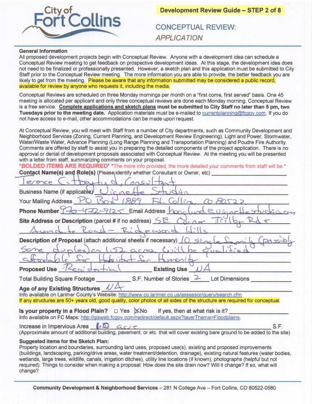
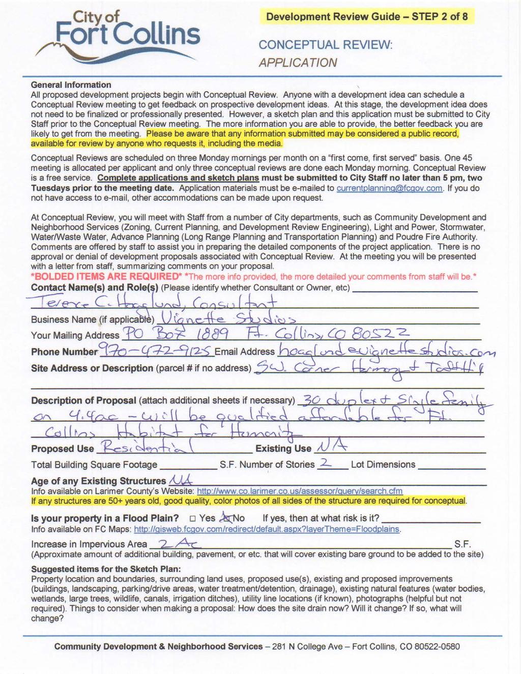
1 Conceptual Review Agenda Schedule for 08/19/13 to 08/19/ Conference Room A Monday, August 19, 2013 Time Project Name Applicant Info Project Description Planner 9:30 Trilby Rd & Avondale Rd - Single Family/Duplex Terence Hoaglund hoaglund@vignettestudios.com This is a request to construct 10 single family homes, and potentially some duplexes on 52 acres of land located at the southeast corner of Trilby Road and Avondale Road (Parcel # ). The residences will qualify as affordable for Habitat for Humanity. The site is located in the Low Density Mixed-Use Neighborhood (L-M-N) Zone District. Single family homes and two-family dwellings are subject to administrative (Type 1) review in the LMN Zone District. Jason Holland 10: W Harmony Rd - Single Family/Duplex Terence Hoaglund hoaglund@vignettestudios.com This is a request to construct 30 units of single family homes and duplexes on 44 acres of land located at 2025 West Harmony Road (Parcel #s & ). The residences will qualify as affordable for Habitat for Humanity. The site is located in the Low Density Mixed-Use Neighborhood (L-M-N) Zone District. Single family and two-family dwellings are subject to administrative (Type 1) review in the LMN Zone District. Jason Holland Agenda as of 08/09/13 at 3:52 pm Page 1 of 1


2 Flagler Rd Taft Hill Constellation Dr Lemay Timberline Lunar Ct S Trilby Rd & Avondale Rd Single Family / Duplex Vicinity Map 287 UV 14 «1 Douglas 25 Aerial Site Map Lunar Ct S Mountain Vista Vine Orbit Way 287 Mulberry Constellation Dr Prospect Shields Drake Horsetooth 25 Pulsar St Harmony ^_ Trilby inch = 17,493 feet W Trilby Rd Zoning Map Orbit Way MMN RL Yuma Pl Pulsar St Yuma Ct Little Peoples Landing Yuma Ct W Trilby Rd LMN Little Peoples Landing Avondale Rd Idalia Ct Idalia Ct Ramah Dr Avondale Rd RL Idalia Dr lagler Rd 1 inch = 417 feet F Idalia Dr 1 inch = 167 feet These map products and all underlying data are developed for use by the City of Fort Collins for its internal purposes only, and were not designed or intended for general use by members of the public. The City makes no representation or warranty as to its accuracy, timeliness, or completeness, and in particular, its accuracy in labeling or displaying dimensions, contours, property boundaries, or placement of location of any map features thereon. THE CITY OF FORT COLLINS MAKES NO WARRANTY OF MERCHANTABILITY OR WARRANTY FOR FITNESS OF USE FOR PARTICULAR PURPOSE, EXPRESSED OR IMPLIED, WITH RESPECT TO THESE MAP PRODUCTS OR THE UNDERLYING DATA. Any users of these map products, map applications, or data, accepts same AS IS, WITH ALL FAULTS, and assumes all responsibility of the use thereof, and further covenants and agrees to hold the City harmless from and against all damage, loss, or liability arising from any use of this map product, in consideration of the City's having made this information available. Independent verification of all data contained herein should be obtained by any users of these products, or underlying data. The City disclaims, and shall not be held liable for any and all damage, loss, or liability, whether direct, indirect, or consequential, which arises or may arise from these map products or the use thereof by any person or entity.
3
4 EXISTING LANDSCAPNG TRILBY RD. AVONDALE COTTAGES CONCEPT SKETCH STUDY 213 NORTH UNIT 3 PLAN A UNIT 4 PLAN A UNIT 5 PLAN A UNIT 6 PLAN C UNIT 8 PLAN A SITE SIDEWALKS AVONDALE RD. UNIT 2 PLAN A UNIT 7 PLAN A UNIT 10 PLAN C UNIT 9 PLAN A OPEN PARKING 52 ACRES 10 UNITS 6.57 DU/AC UNIT 1 PLAN C FORT COLLINS HABITAT FOR HUMANITY, INC. EXISTING DAYCARE GARAGE PARKING (TYP) RECONSTRUCT PARKING TO ALLOW ACCESS EXISTING PRIVATE DRIVE Planning Landscape Architecture Graphics
5 Community Development and Neighborhood Services 281 North College Avenue PO Box 580 Fort Collins, CO fax fcgov.com August 23, 2013 Terence Hoaglund Vignette Studios PO Box 1889 Fort Collins, CO Re: Trilby Rd & Avondale Rd - Single Family/Duplex Description of project: This is a request to construct 10 single family homes, and potentially some duplexes on 52 acres of land located at the southeast corner of Trilby Road and Avondale Road (Parcel # ). The residences will qualify as affordable for Habitat for Humanity. The site is located in the Low Density Mixed-Use Neighborhood (L-M-N) Zone District. Single family homes and two-family dwellings are subject to administrative (Type 1) review in the LMN Zone District. Please see the following summary of comments regarding the project request referrenced above. The comments offered informally by staff during the Conceptual Review will assist you in preparing the detailed components of the project application. Modifications and additions to these comments may be made at the time of formal review of this project. If you have any questions regarding these comments or the next steps in the review process, you may contact the individual commenter or direct your questions through the Project Planner, Clark Mapes, at or cmapes@fcgov.com. Comment Summary: Department: Zoning Contact: Gary Lopez, , glopez@fcgov.com While the detached single family dwellings will require a min. of one off-street parking space each off-street parking for the duplex dwellings units are based on the number of bedrooms per unit. See LUC 2(K). In addition a minimum of 1 bicycle space per bedroom of the duplex dwellings is required with 60% of those enclosed and 40% at fixed racks outdoors. No standards are required for single family dwellings. See LUC 2(C )(4)(b). Will there be exterior trash enclosures? If so the enclosures must match building exteriors in both materials and color with metal doors. These should accommodate recycling containers and an open doorway for must exist to allow individual to access without opening the main doors. See LUC 5 Off-street parking requirements will apply to fee-simple lots in that the parking must occur on that lot whether detached single family or attached single family (duplex proposed). Department: Water-Wastewater Engineering Contact: Roger Buffington, , rbuffington@fcgov.com Page 1 of 6
6 Water and wastewater services for this site are provided by the Fort Collins-Loveland Water District and the South Fort Collins Sanitation District. The Districts can be contacted at (970) Department: Stormwater Engineering Contact: Glen Schlueter, , 6. A drainage report, erosion control report, and construction plans are required and they must be prepared by a Professional Engineer registered in Colorado. The drainage report must address the four-step process for selecting structural BMPs. Standard operating procedures (SOPs) for all onsite drainage facilities need to be prepared by the drainage engineer and there is a final site inspection required when the project is complete and the maintenance is handed over to an HOA or another maintenance organization. The erosion control report requirements are in the Fort Collins Stormwater Manual, Section 3, Volume 3, Chapter 7 of the Fort Collins Amendments. If you need clarification concerning this section, please contact the Erosion Control Inspector, Jesse Schlam at or jschlam@fcgov.com. Stormwater detention for the site was included in the sizing of the detention pond along the east property boundary. However it was not sized using the present rainfall criteria. So the design engineer needs verify that the existing volume is sufficient using the present rainfall. The runoff coefficient used was 0.8 which is pretty high for the sub-basin since it includes the detention pond. A high runoff coefficient was probably used because the site was to be future commercial. This proposal will be an even lower runoff coefficient. Another option may be to show that the site runoff rate is equal to or less than the calculated runoff used in sizing the existing pond. Fifty percent of the site runoff is required to be treated using the standard water quality treatment as described in the Fort Collins Stormwater Manual, Volume 3 - Best Management Practices (BMPs). ( stormwater-criteria) Extended detention is the usual method selected for water quality treatment; however the use of any of the BMPs is encouraged. Low Impact Development (LID) requirements went into effect March 11, 201 These require a higher degree of water quality treatment for 50% of the new impervious area and 25% of new paved areas must be pervious. Please contact Basil Hamdan at or bhamdan@fcgov.com for more information. There is also more information on the EPA web site at: goback=.gde_ _member_ I would suggest that water quality treatment be provided onsite instead of modifying the existing detention pond. If treatment is provided in the existing pond it would need to be sized for the entire area draining to it. There is the option though to modify the existing detention pond. The city wide Stormwater development fee (PIF) is $6,390.00/acre ($0.1467/sq.-ft.) for new impervious area over 350 sq.-ft., and there is a $1,0400/acre ($0.024/sq.-ft.) review fee. No fee is charged for existing impervious area. These fees are to be paid at the time each building permit is issued. Information on fees can be found on the City's web site at or contact Jean Pakech at for questions on fees. There is also an erosion control escrow required before the Development Construction permit is issued. The amount of the escrow is determined by the design engineer, and is based on the site disturbance area, cost of the measures, or a minimum amount in accordance with the Fort Collins Stormwater Manual. The design of this site must conform to the drainage basin design of the Fossil Creek Basin Master Drainage Plan as well the Fort Collins Stormwater Manual. Page 2 of 6
7 Department: Park Planning Contact: Craig Foreman, , 8/12/2013: No comments Department: Fire Authority Contact: Jim Lynxwiler, , WATER SUPPLY Hydrant spacing and flow must meet minimum requirements based on type of occupancy. RESIDENTIAL REQUIREMENTS: Within the Urban Growth Area, hydrants to provide 1,000 gpm at 20 psi residual pressure, spaced not further than 400 feet to the building, on 800-foot centers thereafter International Fire Code and Appendix B FIRE LANES Fire Lanes shall be provided to within 150' of all portions of the building, as measured by an approved route around the exterior of the building. When fire lanes cannot be provided, the fire code official is authorized to increase the dimension of 150 feet if the building is equipped throughout with an approved, automatic fire-sprinkler system International Fire Code 501 As no scale was provided on the site plan, it is unclear if this code requirement is being met. FIRE LANE SPECIFICATIONS A fire lane plan shall be submitted for approval prior to installation. In addition to the design criteria already contained in relevant standards and policies, any new fire lane must meet the following general requirements: > Shall be designated on the plat as an Emergency Access Easement. > Maintain the required 20 foot minimum unobstructed width & 14 foot minimum overhead clearance. > Be designed as a flat, hard, all-weather driving surface capable of supporting 40 tons. > Dead-end fire access roads in excess of 150 feet in length shall be provided with an approved area for turning around fire apparatus. > The required turning radii of a fire apparatus access road shall be a minimum of 25 feet inside and 50 feet outside. Turning radii shall be detailed on submitted plans. > Be visible by painting and/or signage, and maintained unobstructed at all times International Fire Code 503, 504, 505, 503, 504 and Appendix D; FCLUC 6.2(B)2006 and Local Amendments. DEAD-END FIRE LANES Dead-end fire access roads in excess of 150 feet in length shall be provided with an approved area for turning around fire apparatus. FCLUC 6.2(B)2006; International Fire Code 505 and Appendix D As no scale was provided on the site plan, it is unclear if this code requirement is being met. PREMISE IDENTIFICATION New and existing buildings shall be plainly identified. Address numbers shall be visible from the street fronting the property, plainly visible, and posted with a minimum of six-inch numerals on a contrasting Page 3 of 6
8 background International Fire Code SECONDARY ACCESS If the proposed connection to the cul-de-sac cannot be achieved, further discussion is required to determine a secondary access to the site. Department: Environmental Planning Contact: Lindsay Ex, , lex@fcgov.com The applicant should make note of Article 1(C) that requires developments to submit plans that "...(4) protects significant trees, natural systems, and habitat". Note that a significant tree is defined as a tree having DBH (Diameter at Breast Height) of six inches or more. As several of the trees within this site may have a DBH of greater than six inches, a review of the trees shall be conducted with Tim Buchanan, City Forester ( ) to determine the status of the existing trees and any mitigation requirements that could result from the proposed development. With respect to landscaping and design, the City of Fort Collins Land Use Code, in Article 1 (E)(2)(3), requires that you use native plants and grasses in your landscaping or re landscaping and reduce bluegrass lawns as much as possible. Please be aware, the creation or enforcement of covenants that prohibit or limit xeriscape or drought-tolerant landscapes, or that require primarily turf-grass are prohibited by both the State of Colorado and the City of Fort Collins. Department: Electric Engineering Contact: Justin Fields, , jfields@fcgov.com Electric development and system modification charges will apply. An online estimator for these charges is available at -development-fee-estimator. Coordinate utility easements, transformer, and service locations with Light and Power Engineering, (970) Shade trees must maintain 40 feet of clearance with streetlights and ornamental tress must maintain 15 feet of clearance with streetlights. Department: Advance Planning Contact: Andrew Gingerich, , agingerich@fcgov.com Larimer County Road Impact Fees and Street Oversizing Fees are due at the time of building permit. Please contact Matt Baker at if you have any questions. The City's Transportation Development Review Fee (TDRF) is due at the time of submittal. For additional information on these fees, please see: Any damaged curb, gutter and sidewalk existing prior to construction, as well as streets, sidewalks, curbs and gutters, destroyed, damaged or removed due to construction of this project, shall be replaced or restored to City of Fort Collins standards at the Developer's expense prior to the acceptance of completed Page 4 of 6
9 improvements and/or prior to the issuance of the first Certificate of Occupancy Please contact the City's Traffic Engineer, Joe Olson ( ) to schedule a scoping meeting and determine if a traffic study is needed for this project. In addition, please contact Transportation Planning for their requirements as well. Any public improvements must be designed and built in accordance with the Larimer County Urban Area Street Standards (LCUASS). They are available online at: Utility plans will be required and a Development Agreement will be recorded once the project is finalized. This project is responsible for dedicating any right-of-way and easements that are necessary for this project. Avondale is a collector street with on street parking requiring 76 of total right of width. It was difficult to verify from the materials provided if this full width is being achieved currently and will need to be reviewed at the time of PDP submittal. After further conversations after the meeting it was determined that no additional right of way will be required. Taking access off the cul de sac will result in the loss of parking spaces and this could affect the existing site plan. Please confirm with zoning department on any requirements. It appears that truncated domes are not located on either the Trilby or Avondale intersection corners and need to be included as a part of this project. As discussed at Conceptual review there is a reduction in certain fees based upon the percentage of Affordable Housing. Our department needs a letter from the City affordable housing department stating the percentage. We will reduce the TDRF fees by that percentage as well as the public infrastructure escrow at time of construction. Current Planning Contact: Clark Mapes, , cmapes@fcgov.com The approved Ridgewood Hills ODP must be amended in conjunction with this development plan - it clearly identifies this parcel for convenience commercial use. The relationship of homes to streets is an important aspect of development. A Connecting Walkway is required to the front facades of the homes, without crossing vehicle use areas or going around buildings or parking lots. The plan as shown does not meet the standard given the orientation of units primarily to an internal parking drive. A Modification of Standard would be required to support a different plan that is as good or better than a plan that meets the standard. Model variety is required - at least 3 distinct different models in this case with different floor plans and elevations, and no two identical models next to each other. The proposed development project is subject to a Type 1 review and public hearing, the decision maker for Type 1 hearings is an Administrative Hearing Officer. The applicant for this development request is not required to hold a neighborhood meeting for a Type 1 hearing, but if you would like to have one to notify your neighbors of the proposal, please let me know and I can help you in setting a date, time and location for a meeting. Neighborhood Meetings are a great way to get public feedback and avoid potential hiccups that may occur later in the review process. Please see the Development Review Guide at This online guide features a color coded flowchart with comprehensive, easy to read information on each step in the process. This guide includes links to just about every resource you need during development review. Page 5 of 6
10 This development proposal will be subject to all applicable standards of the Fort Collins Land Use Code (LUC), including Article 3 General Development Standards. The entire LUC is available for your review on the web at If this proposal is unable to satisfy any of the requirements set forth in the LUC, a Modification of Standard Request will need to be submitted with your formal development proposal. Please see Section 8.2 of the LUC for more information on criteria to apply for a Modification of Standard. Please see the Submittal Requirements and Checklist at: The request will be subject to the Development Review Fee Schedule that is available in the Community Development and Neighborhood Services office. The fees are due at the time of submittal of the required documents for the appropriate development review process by City staff and affected outside reviewing agencies. Also, the required Transportation Development Review Fee must be paid at time of submittal. When you are ready to submit your formal plans, please make an appointment with Community Development and Neighborhood Services at (970) Page 6 of 6

11 S Taft Hill Rd Taft Hill Lemay Timberline S Taft Hill Rd 2025 W Harmony Rd Single Family / Duplex Vicinity Map 287 UV 14 «1 Douglas 25 Aerial Site Map Mountain Vista Westfield Dr Vine 287 Prospect Mulberry Goodell Ln Shields Drake Horsetooth 25 ^_ Harmony Trilby 287 W County Road 38e 25 1 inch = 17,493 feet W Harmony Rd Zoning Map Westfield Dr Goodell Ln Lynda Ln Lookout Ln W Harmony Rd LMN Lookout Ln Trail View Ln Brixton Rd RL Brixton Rd Mesaview Ct Whippeny Dr Mesaview Ct Mesaview Ln 1 inch = 500 feet Mesaview Ln 1 inch = 225 feet These map products and all underlying data are developed for use by the City of Fort Collins for its internal purposes only, and were not designed or intended for general use by members of the public. The City makes no representation or warranty as to its accuracy, timeliness, or completeness, and in particular, its accuracy in labeling or displaying dimensions, contours, property boundaries, or placement of location of any map features thereon. THE CITY OF FORT COLLINS MAKES NO WARRANTY OF MERCHANTABILITY OR WARRANTY FOR FITNESS OF USE FOR PARTICULAR PURPOSE, EXPRESSED OR IMPLIED, WITH RESPECT TO THESE MAP PRODUCTS OR THE UNDERLYING DATA. Any users of these map products, map applications, or data, accepts same AS IS, WITH ALL FAULTS, and assumes all responsibility of the use thereof, and further covenants and agrees to hold the City harmless from and against all damage, loss, or liability arising from any use of this map product, in consideration of the City's having made this information available. Independent verification of all data contained herein should be obtained by any users of these products, or underlying data. The City disclaims, and shall not be held liable for any and all damage, loss, or liability, whether direct, indirect, or consequential, which arises or may arise from these map products or the use thereof by any person or entity.
12


13 HARMONY COTTAGES CONCEPT PLAN A ALL UNITS HAVE ACCESS TO THE CEN- TRAL WALKWAY SPINE AND COMMUNITY GREENS HARMONY ROAD LAND USE SUMMARY PROJECT AREA 4 AC DUPLEX COTTAGES 18 SINGLE FAMILY COTTAGES 12 TOTAL COTTAGES 30 DENSITY 6.8 DU/AC MAIN STREET WITH HOMES FACING STREET, PARALLEL PARK- ING AND STREET TREES S. TAFT HILL ROAD DUPLEXES GARAGES PROVIDE SCREENING FOR ADJACENT HOMES SINGLE FAMILY DETACHED HOMES AUGUST 1, 2013
14 Community Development and Neighborhood Services 281 North College Avenue PO Box 580 Fort Collins, CO fax fcgov.com August 23, 2013 Terence Hoaglund Vignette Studios PO Box1889 Fort Collins, CO Re: 2025 W Harmony Rd - Single Family/Duplex Description of project: This is a request to construct 30 units of single family homes and duplexes on 44 acres of land located at 2025 West Harmony Road (Parcel #s & ). The residences will qualify as affordable for Habitat for Humanity. The site is located in the Low Density Mixed-Use Neighborhood (L-M-N) Zone District. Single family and two-family dwellings are subject to administrative (Type 1) review in the LMN Zone District. Please see the following summary of comments regarding the project request referrenced above. The comments offered informally by staff during the Conceptual Review will assist you in preparing the detailed components of the project application. Modifications and additions to these comments may be made at the time of formal review of this project. If you have any questions regarding these comments or the next steps in the review process, you may contact the individual commenter or direct your questions through the Project Planner, Pete Wray, at or pwray@fcgov.com. Comment Summary: Department: Zoning Contact: Gary Lopez, , glopez@fcgov.com 6. While the detached single family dwellings will require a min. of one off-street parking space each off-street parking for the duplex dwellings units are based on the number of bedrooms per unit. See LUC 2(K). In addition a minimum of 1 bicycle space per bedroom of the duplex dwellings is required with 60% of those enclosed and 40% at fixed racks outdoors. No standards are required for single family dwellings. See LUC 2(C )(4)(b). Will there be exterior trash enclosures? If so the enclosures must match building exteriors in both material and color with metal doors. These should accomodate recycling containers and an open doorway for must exist to allow individual to access without opening the main doors. See LUC 5 Can the 4-car garage attached to the small parking lot closest to Harmony be moved to the south and the house behind it moved in it's place? Any consideration to solid fencing the south and east sides of the Ft. Collins - Loveland Water District property at the s-e corner or W Harmony Rd and S Taft Hill Road? Off-street parking requirements will apply to fee-simple lots in that the parking must occur on that lot whether detached single family or attached single family (duplex proposed). Page 1 of 6
15 Department: Water-Wastewater Engineering Contact: Roger Buffington, , Existing water mains and sanitary sewers in this area include a 16-inch water main in Harmony, an 8-inch sewer in Center Gate Ct and an 8-inch sewer at corner of Lookout Lane and Trail View. The water main must be looped through the site. The water conservation standards for landscape and irrigation will apply. Information on these requirements can be found at: Development fees and water rights will be due at building permit. Repays will also be due for the 16-inch water main in Harmony and the Warren Lake Trunk sewer. Separate water and sewer services are required for each unit. Department: Stormwater Engineering Contact: Glen Schlueter, , gschlueter@fcgov.com A drainage report, erosion control report, and construction plans are required and they must be prepared by a Professional Engineer registered in Colorado. The drainage report must address the four-step process for selecting structural BMPs. Standard operating procedures (SOPs) for all onsite drainage facilities need to be prepared by the drainage engineer and there is a final site inspection required when the project is complete and the maintenance is handed over to an HOA or another maintenance organization. The erosion control report requirements are in the Fort Collins Stormwater Manual, Section 3, Volume 3, Chapter 7 of the Fort Collins Amendments. If you need clarification concerning this section, please contact the Erosion Control Inspector, Jesse Schlam at or jschlam@fcgov.com. In Mail Creek drainage basin onsite detention is required with a 2 year release rate. The Woodridge system may have been sized for this site. If the design engineer can verify that, there would still be a requirement for water quality treatment and there would be detention required for the difference in the old rainfall and the present rainfall requirements. Also the imperviousness assumed would need to be verified as being consistent with the previously approved report, again, if the original report included this site in sizing the detention. There are offsite flows that need to be considered. The design engineer can get the master plan information and model (SWMM) to evaluate the offsite flows that will need to pass through the site. There may be some overflow of Taft Hill Road from the County developments to the west and it appears the backs of the homes on Lookout Lane may drain onto the site. There is a channel along the back of the lots. These flows do not need to be detained but need to pass through the site safely. Fifty percent of the site runoff is required to be treated using the standard water quality treatment as described in the Fort Collins Stormwater Manual, Volume 3 - Best Management Practices (BMPs). ( stormwater-criteria) Extended detention is the usual method selected for water quality treatment; however the use of any of the BMPs is encouraged. Low Impact Development (LID) requirements went into effect March 11, 201 These require a higher degree of water quality treatment for 50% of the new impervious area and 25% of new paved areas must be pervious. Please contact Basil Hamdan at or bhamdan@fcgov.com for more information. There is Page 2 of 6
16 also more information on the EPA web site at: goback=.gde_ _member_ LID design information can be found on the City's web site at: stormwater-criteria The site layout appears to be a little close to the south property line to accommodate a drainage swale along the property line. Any drainage swales must be in separate tracts and cannot be on private properties. There is the option to route the runoff from the existing lots through the site and not have a swale along the property line. The storm sewer shown on the utility map on the north side of Harmony may not exist yet so the design engineer will need to verify that it is there and has capacity for this site to drain to it if that is the desired outfall to be used. The city wide Stormwater development fee (PIF) is $6,390.00/acre ($0.1467/sq.-ft.) for new impervious area over 350 sq.-ft., and there is a $1,0400/acre ($0.024/sq.-ft.) review fee. No fee is charged for existing impervious area. These fees are to be paid at the time each building permit is issued. Information on fees can be found on the City's web site at or contact Jean Pakech at for questions on fees. There is also an erosion control escrow required before the Development Construction permit is issued. The amount of the escrow is determined by the design engineer, and is based on the site disturbance area, cost of the measures, or a minimum amount in accordance with the Fort Collins Stormwater Manual. The design of this site must conform to the drainage basin design of the Mail Creek Master Plan Update as well the Fort Collins Stormwater Manual. Department: Park Planning Contact: Craig Foreman, , cforeman@fcgov.com 8/12/2013: No comments Department: Fire Authority Contact: Jim Lynxwiler, , jlynxwiler@poudre-fire.org WATER SUPPLY Hydrant spacing and flow must meet minimum requirements based on type of occupancy. RESIDENTIAL REQUIREMENTS: Within the Urban Growth Area, hydrants to provide 1,000 gpm at 20 psi residual pressure, spaced not further than 400 feet to the building, on 800-foot centers thereafter International Fire Code and Appendix B FIRE LANES Fire Lanes shall be provided to within 150' of all portions of the building, as measured by an approved route around the exterior of the building. When fire lanes cannot be provided, the fire code official is authorized to increase the dimension of 150 feet if the building is equipped throughout with an approved, automatic fire-sprinkler system International Fire Code 501 FIRE LANE SPECIFICATIONS A fire lane plan shall be submitted for approval prior to installation. In addition to the design criteria already Page 3 of 6
17 contained in relevant standards and policies, any new fire lane must meet the following general requirements: > Shall be designated on the plat as an Emergency Access Easement. > Maintain the required 20 foot minimum unobstructed width & 14 foot minimum overhead clearance. > Be designed as a flat, hard, all-weather driving surface capable of supporting 40 tons. > Dead-end fire access roads in excess of 150 feet in length shall be provided with an approved area for turning around fire apparatus. > The required turning radii of a fire apparatus access road shall be a minimum of 25 feet inside and 50 feet outside. Turning radii shall be detailed on submitted plans. > Be visible by painting and/or signage, and maintained unobstructed at all times International Fire Code 503, 504, 505, 503, 504 and Appendix D; FCLUC 6.2(B)2006 and Local Amendments. TURNING RADII The required turning radii of a fire apparatus access road shall be a minimum of 25 feet inside and 50 feet outside. These turning radii shall apply to all portions of the fire lane including the proposed roundabout on the SW portion of the site. International Fire Code 504 and Local Amendments DEAD-END FIRE LANES Dead-end fire apparatus access roads cannot exceed 660 feet in length. Dead-end fire access roads in excess of 150 feet in length shall be provided with an approved area for turning around fire apparatus. FCLUC 6.2(B)2006; International Fire Code 505 and Appendix D This code requirement is not being met on the current conceptual site plan. At the cr meeting, the applicant proposed the addition of another connection to Harmony Rd. at the west end of the project. This connection, while resolving fire department concerns, may present other obstacles for transportation coordination. Further discussion is recommended. 6. PREMISE IDENTIFICATION New and existing buildings shall be plainly identified. Address numbers shall be visible from the street fronting the property, plainly visible, and posted with a minimum of six-inch numerals on a contrasting background International Fire Code 501 Department: Environmental Planning Contact: Lindsay Ex, , lex@fcgov.com With respect to landscaping and design, the City of Fort Collins Land Use Code, in Article 1 (E)(2)(3), requires that you use native plants and grasses in your landscaping or re landscaping and reduce bluegrass lawns as much as possible. Please be aware, the creation or enforcement of covenants that prohibit or limit xeriscape or drought-tolerant landscapes, or that require primarily turf-grass are prohibited by both the State of Colorado and the City of Fort Collins. Department: Engineering Development Review Contact: Marc Virata, , mvirata@fcgov.com Larimer County Road Impact Fees and Street Oversizing Fees are due at the time of building permit. Please contact Matt Baker at if you have any questions. Page 4 of 6
18 The City's Transportation Development Review Fee (TDRF) is due at the time of submittal. For additional information on these fees, please see: Any damaged curb, gutter and sidewalk existing prior to construction, as well as streets, sidewalks, curbs and gutters, destroyed, damaged or removed due to construction of this project, shall be replaced or restored to City of Fort Collins standards at the Developer's expense prior to the acceptance of completed improvements and/or prior to the issuance of the first Certificate of Occupancy. Please contact the City's Traffic Engineer, Joe Olson ( ) to schedule a scoping meeting and determine if a traffic study is needed for this project. In addition, please contact Transportation Planning for their requirements as well. Any public improvements must be designed and built in accordance with the Larimer County Urban Area Street Standards (LCUASS). They are available online at: This project is responsible for dedicating any right-of-way and easements that are necessary for this project. As the previous plat for Innovation Island was recorded, easements internal to the project have been dedicated based upon the previous layout. A replat to vacate and dedicate easements based on the proposed design may be an approach, as well as vacating and dedicating by separate document. The dedication of each easement by separate document costs $250 (plus Larimer County recordation fees) and the vacation of each easement by separate document costs $400 (plus Larimer County recordation fees) as part of the City TDRF schedule. The internal roadways if intended to be public streets, would need to be designed and built to public street standards. If emergency access is being proposed off of Taft Hill Road and/or Harmony Road, the access will need to be built with driveover curb and the placement of bollards would need to be outside of public right-of-way. Further design coordination should then occur with PFA. The two apparent accesses onto Harmony Road appear to be consistent with the previous Innovation Island submittal, however their access spacing and location will need to be formally reviewed with the new submittal and not necessarily guaranteed. Variances to LCUASS may be needed for approval. (Note that access and intersection spacing requirements are not as strict with the internal roadway being private drives instead of public streets.) The development agreement for the previous submittal, Innovation Island indicated the requirement for repayments to the City of $40, and $15,5509 for the cost to contruct Harmony Road and Taft Hill Road respectively. These dollar amount would need to be updated as the dollar amounts in the development agreement were established based upon 2007 dollars. Construction plans will be required. A Development Agreement will be required and recorded once the project is finalized with recordation costs paid for by the applicant. A Development Construction Permit (DCP) will need to be obtained prior to starting any work on the site. Department: Electric Engineering Contact: Justin Fields, , jfields@fcgov.com Electric development and system modification charges will apply. An online estimator for these charges is available at Page 5 of 6
19 -development-fee-estimator. Coordinate utility easements, transformer, and service locations with Light and Power Engineering, (970) Shade trees must maintain 40 feet of clearance with streetlights and ornamental tress must maintain 15 feet of clearance with streetlights. Current Planning Contact: Pete Wray, , The City's Planning Development Review Fee is due at time of submittal. For additional information on these fees see: The proposed development project and uses in the Low Density Mixed-use Neighborhoods zoning is subject to a Type I administrative review process. Streetscape improvements required along South Tafft Hill Road. The proposed development project is subject to a Type 1 review and public hearing, the decision maker for Type 1 hearings is an Administrative Hearing Officer. The applicant for this development request is not required to hold a neighborhood meeting for a Type 1 hearing, but if you would like to have one to notify your neighbors of the proposal, please let me know and I can help you in setting a date, time and location for a meeting. Neighborhood Meetings are a great way to get public feedback and avoid potential hiccups that may occur later in the review process. Please see the Development Review Guide at This online guide features a color coded flowchart with comprehensive, easy to read information on each step in the process. This guide includes links to just about every resource you need during development review. This development proposal will be subject to all applicable standards of the Fort Collins Land Use Code (LUC), including Article 3 General Development Standards. The entire LUC is available for your review on the web at If this proposal is unable to satisfy any of the requirements set forth in the LUC, a Modification of Standard Request will need to be submitted with your formal development proposal. Please see Section 8.2 of the LUC for more information on criteria to apply for a Modification of Standard. Please see the Submittal Requirements and Checklist at: The request will be subject to the Development Review Fee Schedule that is available in the Community Development and Neighborhood Services office. The fees are due at the time of submittal of the required documents for the appropriate development review process by City staff and affected outside reviewing agencies. Also, the required Transportation Development Review Fee must be paid at time of submittal. When you are ready to submit your formal plans, please make an appointment with Community Development and Neighborhood Services at (970) Page 6 of 6
Filing 6. The replat includes eliminating the alley load tract and widening other lots. The site is zoned Low Density Mixed Use Residential.
 Community Development and Neighborhood Services 281 North College Avenue PO Box 580 Fort Collins, CO 80522 970.226750 970.226134 - fax fcgov.com October 31, 2012 Re: Rigden Farm 6th Filing Replat Description
Conceptual Review Agenda
 Conceptual Review Agenda Schedule for 07/29/13 to 07/29/13 281 Conference Room A Monday, July 29, 2013 Time Project Name Applicant Info Project Description Planner 9:30 4101 S Taft Hill Rd - Annexation
Penny Flats North 323 N Mason
 Taft Hill Lemay Mason Ct Timberline Mason Ct Penny Flats North 323 N Mason Vicinity Map Aerial Site Map 287 «1 Douglas 25 Mountain Vista UV 14 287 ^_ Vine Mulberry Prospect Shields Drake Horsetooth 25
Conceptual Review Agenda
 Conceptual Review Agenda Schedule for 11/13/17 to 11/13/17 281 Conference Room A Monday, November 13, 2017 Time Project Name Applicant Info Project Description Planner 9:30 Voice of Truth Tabernacle CDR170069
Conceptual Review Agenda
 Conceptual Review Agenda Schedule for 09/12/11 to 09/12/11 281 Conference Room A Monday, September 12, 2011 Time Project Name Applicant Info Project Description Planner 9:30 Mayor of Old Town Pation -
Conceptual Review Agenda
 Conceptual Review Agenda Schedule for 06/18/12 to 06/18/12 281 Conference Room A Monday, June 18, 2012 Time Project Name Applicant Info Project Description Planner 10:15 McClelland's Creek Filing 3 - Replat
Conceptual Review Agenda
 Conceptual Review Agenda Schedule for 06/07/18 to 06/07/18 281 Conference Room A Thursday, June 7, 2018 Time Project Name Applicant Info Project Description 9:30 10:15 1314 Red Cedar Circle CDR180035 2155
Conceptual Review Agenda
 Conceptual Review Agenda Schedule for 05/08/17 to 05/08/17 281 Conference Room A Monday, May 8, 2017 Time Project Name Applicant Info Project Description Planner 9:30 920 S Overland Trail - Single-Family
Conceptual Review Agenda
 Conceptual Review Agenda Schedule for 03/19/18 to 03/19/18 281 Conference Room A Monday, March 19, 2018 Time Project Name Applicant Info Project Description Planner 9:30 Purpose Brewing CDR180013 Zach
Conceptual Review Agenda
 Conceptual Review Agenda Schedule for 12/13/18 281 Conference Room A Thursday, December 13, 2018 Time Project Name Applicant Info Project Description 9:30 1909 Harmony Dr CDR180091 Christopher Martin 970-388-6690
Jerome Street Mixed Use
 Jerome Street Mixed Use Aerial Site Map 287 N Mason St 1 «Douglas 25 Pinon St _ ^ Vine 287 Mulberry Horsetooth Timberline Drake Lemay Shields Prospect N College Ave 14 U V Taft Hill Mountain Vista Jerome
Conceptual Review Agenda
 Conceptual Review Agenda Schedule for 06/21/18 to 06/21/18 281 Conference Room A Thursday, June 21, 2018 Time Project Name Applicant Info Project Description 9:30 200 E Swallow Rd CDR180041 This is a request
Conceptual Review Agenda
 Conceptual Review Agenda Schedule for 10/18/18 281 Conference Room A Thursday, October 18, 2018 Time Project Name Applicant Info Project Description 9:30 915 E Prospect Rd Kaycee Heid This is a request
Conceptual Review Agenda
 Conceptual Review Agenda Schedule for 06/14/18 to 06/14/18 281 Conference Room A Thursday, June 14, 2018 Time Project Name Applicant Info Project Description Planner 9:30 Sunshine House CDR180038 Bo Brown
COMMERCIAL SITE PLAN & CONDITIONAL USE PERMIT REVIEW PROCESS & CHECKLIST
 Community Development 110 South Main Street Springville, UT 84663 COMMERCIAL SITE PLAN & CONDITIONAL USE PERMIT REVIEW PROCESS & CHECKLIST 801.491.7861 www.springville.org Prior to the issuance of a building
WORK SESSION ITEM City Council
 DATE: STAFF: February 23, 2016 Ginny Sawyer, Policy and Proect Manager Ted Shepard, Chief Planner WORK SESSION ITEM City Council SUBJECT FOR DISCUSSION Short Term Rentals. EXECUTIVE SUMMARY The purpose
BYRON TOWNSHIP ZONING APPLICATION
 BYRON TOWNSHIP ZONING APPLICATION Phone: (616) 878-9104 * Fax: (616) 878-3980 * Website: www.byrontownship.org This application will not be accepted if incomplete. APPLICATION FOR & REQUIRED COPIES Private
ARTICLE IV: DEVELOPMENT STANDARDS
 ARTICLE IV: DEVELOPMENT STANDARDS IV-53 409 PRIVATE STREETS A private street means any way that provides ingress to, or egress from, property by means of vehicles or other means, or that provides travel
Residential Major Subdivision Review Checklist
 Residential Major Subdivision Review Checklist Plan Submittal Requirements: 2 full sets of stamped plans Electric submittal - all plans contained in a single PDF 3 full sets if commercial kitchen or dining
AGENDA OF THE COUNCIL OF THE CITY OF FORT COLLINS, COLORADO
 AGENDA OF THE COUNCIL OF THE CITY OF FORT COLLINS, COLORADO April 2, 2002 Proclamations and Presentations 5:30 p.m A. Proclamation Proclaiming the Month of April as Strategic Information Management Month.
Staff Report to the North Ogden Planning Commission
 Staff Report to the North Ogden Planning Commission SYNOPSIS / APPLICATION INFORMATION Application Request: Consideration and action on an administrative application for final approval for the Legacy North
Staff Report to the North Ogden City Council
 Staff Report to the North Ogden City Council SYNOPSIS / APPLICATION INFORMATION Application Request: Consideration and action on an administrative application to provide comments on the preliminary plan
CITY OF FERNDALE HEARING EXAMINER
 CITY OF FERNDALE HEARING EXAMINER RE: Planned Unit Development ) 16001-PUD Preliminary Plat ) 16018-SE Plat Variance ) 16002-VAR Application by ) ) MD General, L.L.C. ) FINDINGS OF FACT, Malloy Heights
Residential Minor Subdivision Review Checklist
 Residential Minor Subdivision Review Checklist Plan Submittal Requirements: 2 full sets of stamped plans Electric submittal - all plans contained in a single PDF 3 full sets if commercial kitchen or dining
Re: Case # ZP Preplanning Application for 8 townhomes at 1526 Ingalls Street in Lakewood, CO.
 Planning Department Civic Center North 480 South Allison Parkway Lakewood, Colorado 80226-3127 303.987.7505 303.987.7057 TTY/TDD Lakewood.org/Planning February 27, 2017 Nathan Taylor 601 S Jason Street
SITE PLAN REVIEW ADMINISTRATIVE REVIEW. Please Note: Once submitted to the County, all application materials become a matter of public record.
 200 W. Oak Street, 3rd Floor Fort Collins, CO 80521 (970) 498-7683 / larimer.org/planning SITE PLAN REVIEW ADMINISTRATIVE REVIEW The submittal requirements listed in this packet are intended to collect
STAFF REPORT FOR MAJOR SUBDIVISION
 STAFF REPORT FOR MAJOR SUBDIVISION FINAL PLAT CASE NO. FA-13-001 HEARING DATE: November 6, 2013 CASE NAME: Solterra Subdivision Filing No. 14 PROCEDURE: Planning Commission ADDRESS OF MAJOR SUBDIVISION
CITY OF OCOEE LAND DEVELOPMENT CODE SUFFICIENCY TABLE WITH NOTES
 CITY OF OCOEE LAND DEVELOPMENT CODE SUFFICIENCY TABLE WITH NOTES The Sufficiency Table is a checklist to help identify the types of information and documentation needed for various types of projects. The
DAUPHIN CREEK ESTATES SUBDIVISION
 # 12 SUB-000076-2017 DAUPHIN CREEK ESTATES SUBDIVISION Engineering Comments: FINAL PLAT COMMENTS (should be addressed prior to submitting the FINAL PLAT for review and/or signature by the City Engineer):
City of Melissa, Texas Plat Dedication Language
 City of Melissa, Texas Plat Dedication Language [INCLUDE THE FOLLOWING DEDICATION LANGUAGE FOR INDIVIDUALS (MODIFY APPROPRIATELY TO REFLECT EXACTLY AS SHOWN ON PROPERTY DEED)]: NOW THEREFORE, KNOW ALL
TOWN OF LEWISTON PLANNING BOARD APPLICATION
 TOWN OF LEWISTON PLANNING BOARD APPLICATION DESCRIPTION OF PROPOSED REQUEST: Name of Property Owner: Phone #: Name of Applicant:Phone #: Address or Location of Proposal:_SBL# Size of Parcel or Structure:Existing
COMMUNITY DEVELOPMENT DEPARTMENT 333 Broadalbin Street SW, P.O. Box 490 Albany OR 97321
 COMMUNITY DEVELOPMENT DEPARTMENT 333 Broadalbin Street SW, P.O. Box 490 Albany OR 97321 NOTICE OF DECISION DATE OF NOTICE: August 16, 2016 FILE: TYPE OF APPLICATION: REVIEW BODY: SD-01-16 Ph: 541-917-7550
Section Preliminary Plat Checklist and Application Forms
 Section 201 - Preliminary Plat Checklist and Application Forms PRELIMINARY SUBDIVISION PLAT REVIEW PROCESS CHART PRELIMINARY SUBDIVISION PLAT APPLICATION PRELIMINARY PLAT REVIEW CHECKLIST CITY OF NAMPA
PLANNING COMMISSION REPORT Regular Agenda Non Public Hearing Item
 PC Staff Report 3/23/15 FDP-14-00551 Item No. 2-1 PLANNING COMMISSION REPORT Regular Agenda Non Public Hearing Item PC Staff Report 3/23/15 ITEM NO. 2: FINAL DEVELOPMENT PLAN FOR HUTTON FARMS WEST PHASE
STAFF REPORT FOR MAJOR SUBDIVISION
 STAFF REPORT FOR MAJOR SUBDIVISION FINAL PLAT CASE NO. FA-14-001 HEARING DATE: January 6, 2016 CASE NAME: Solterra Subdivision Filing No. 16 PROCEDURE: Planning Commission ADDRESS OF MAJOR SUBDIVISION
DEVELOPMENT DEPARTMENT STAFF REPORT THE PARK AT 5 TH
 DEVELOPMENT DEPARTMENT STAFF REPORT ARB Meeting Date: July 3, 2018 Item #: _PZ2018-293_ THE PARK AT 5 TH Request: Site Address: Project Name: Parcel Number: Applicant: Proposed Development: Current Zoning:
M E M O R A N D U M. Meeting Date: October 23, Item No. F-1. Planning and Zoning Commission. Daniel Turner, Planner I
 M E M O R A N D U M Meeting Date: October 23, 2017 Item No. F-1 To: From: Subject: Planning and Zoning Commission Daniel Turner, Planner I PUBLIC HEARING: Consider a recommendation of a of Planned Development
Accessory Dwelling Unit Permit
 PLANNING SERVICES DEPARTMENT 411 Main Street (530) 87-6800 P.O. Box 3420 Chico, CA 527 Application No. APPLICATION FOR Accessory Dwelling Unit Permit Applicant Information Applicant Street Address Daytime
SKETCH PLAN REVIEW SPECIAL EXCEPTION, SPECIAL REVIEW,
 www.larimer.org Planning Department 200 W. Oak Street 3 rd Floor Fort Collins, CO 80521 970-498-7683 SKETCH PLAN REVIEW SKETCH PLAN REVIEW for Conservation Developments, Planned Land Divisions, Subdivisions,
Hansen Farm Project Development Plan 2 nd Neighborhood Meeting Notes (12/13/2017)
") Community Development and Neighborhood Services Planning Services 281 North College Ave. P.O. Box 580 Fort Collins, CO 80522 970.221.6750 970.224.6134 - fax fcgov.com/developmentreview Hansen Farm Project
Community Development and Neighborhood Services Planning Services 281 North College Ave. P.O. Box 580 Fort Collins, CO 80522 970.221.6750 970.224.6134 - fax fcgov.com/developmentreview Hansen Farm Project
PLANNED DEVELOPMENT DISTRICT STANDARDS. Cadence Site
 PLANNED DEVELOPMENT DISTRICT STANDARDS Cadence Site A Planned Development District 1. Statement of General Facts, Conditions and Objectives Property Size: Approximately 57.51 Acres York County Tax Map
GENERAL PLAN, DEVELOPMENT CODE AND ZONING MAP AMENDMENT APPLICATION INFORMATION SHEET
 GENERAL PLAN, DEVELOPMENT CODE AND ZONING MAP AMENDMENT APPLICATION INFORMATION SHEET GENERAL INFORMATION This information sheet explains how an application requesting an amendment to the Truckee General
REQUEST FOR ALTERATION REVIEW VERANDA GARDENS HOMEOWNERS ASSOCIATION, INC.
 Please Complete The Following Name: Directions: 1. Fill in requested information 2. Attach required checks Address: 3. Attach required certificates 4. Sign required forms and return to: Lot number GRS
CHECKLIST FOR DEVELOPMENT REVIEW
 CHECKLIST FOR DEVELOPMENT REVIEW Petitions and related documents and plans for land development or other proposals regulated by Title 16 of the Municipal Code (Development Ordinance) and Title 17 of the
City of Ferndale CITY COUNCIL STAFF REPORT
 SUBJECT: Final Plat Approval DATE: January 19, 2016 FROM: Haylie Miller, Assistant Planner PRESENTATION BY: Haylie Miller City of Ferndale CITY COUNCIL STAFF REPORT MEETING DATE: January 19, 2016 AGENDA
CHAPTER 26 PLANNING AND ZONING ARTICLE VII. MOBILE HOMES AND RECREATIONAL VEHICLE (RV) PARKS. Recreational Vehicle (RV) Park Development Standards
 PARKS. Recreational Vehicle (RV) Park Development Standards") CHAPTER 26 PLANNING AND ZONING ARTICLE VII. MOBILE HOMES AND RECREATIONAL VEHICLE (RV) PARKS. Section 26-VII-1. Section 26-VII-2. Section 26-VII-3. Section 26-VII-4. Section 26-VII-5. Purpose Permitted
CHAPTER 26 PLANNING AND ZONING ARTICLE VII. MOBILE HOMES AND RECREATIONAL VEHICLE (RV) PARKS. Section 26-VII-1. Section 26-VII-2. Section 26-VII-3. Section 26-VII-4. Section 26-VII-5. Purpose Permitted
Initial Project Review
 Pierce County Department of Planning and Land Services, 2401 South 35th Street, Tacoma, WA (253) 798-7037 Initial Project Review Major Amendment to Preliminary Plat: Hawks Ridge Division 1 Application
BEFORE THE HEARING EXAMINER FOR THURSTON COUNTY
 COUNTY COMMISSIONERS Cathy Wolfe District One Diane Oberquell District Two Robert N. Macleod District Three HEARING EXAMINER BEFORE THE HEARING EXAMINER FOR THURSTON COUNTY In the Matter of the Application
City of Midland Application for Site Plan Review
 City of Midland Application for Site Plan Review Submission Date: Property Owner: Mailing Address: Phone number: ( ) Cell phone: ( ) Email address: Fax: ( ) Owner s Signature: Applicant Name (if not owner):
4.2 RESIDENTIAL ZONING DISTRICTS
 4.2 RESIDENTIAL ZONING DISTRICTS A. Purpose: To define regulations and standards for each residential zoning district in the City. The following sections identify uses, regulations, and performance standards
Time Extension Staff Report
 Time Extension Staff Report Subdivision Name Lunara Subdivision File Number SUB07-00019 Approval Time Extension for Lead Agency Boise City Certification Signature of Boise City Engineer Annexation Date
ARTICLE 3 DEFINITIONS
 Sections: 3-1 Rules of Construction 3-2 Definitions ARTICLE 3 DEFINITIONS SECTION 3-1 RULES OF CONSTRUCTION 3-101. a. The language set forth in these regulations shall be interpreted in accordance with
Condominium Unit Requirements.
 ARTICLE 19 CONDOMINIUM REGULATIONS Section 19.01 Purpose. The purpose of this Article is to regulate projects that divide real property under a contractual arrangement known as a condominium. New and conversion
WESTMINSTER PARK PLACE SUBDIVISION
 WESTMINSTER PARK PLACE SUBDIVISION Engineering Comments: FINAL PLAT COMMENTS (should be addressed prior to submitting the FINAL PLAT for review and/or signature by the City Engineer): A. Provide all of
Packet Contents: Page #
 CLEAR CREEK COUNTY PLANNING DEPARTMENT REQUIREMENTS FOR COMMERCIAL AND MULTI-FAMILY DEVELOPMENTS Prior to submitting a building permit application, the Planning staff will review the site plan and construction
WASHINGTON COUNTY CUP SUBMITTAL CHECKLIST
 WASHINGTON COUNTY CUP SUBMITTAL CHECKLIST The following must be turned in to the Planning Office by the submittal date for your CUP to be reviewed by the Planning Board. (Incomplete applications will not
Submittal Requirements: Subdivision Plat (Final)
") s Planning and Zoning Submittal Requirements: Subdivision Plat (Final) 1. Application form, APO fees, and filing fee. Transportation Development Review Fee please contact Engineering at (970) 221-6605
s Planning and Zoning Submittal Requirements: Subdivision Plat (Final) 1. Application form, APO fees, and filing fee. Transportation Development Review Fee please contact Engineering at (970) 221-6605
PREPARED FOR THE URBAN DESIGN COMMISSION AND PLAN COMMISSION
 PLANNING DIVISION STAFF REPORT PREPARED FOR THE URBAN DESIGN COMMISSION AND PLAN COMMISSION Project Address: Application Type: Prepared By: Demolition Permit and Conditional Use Kevin Firchow, AICP, Planning
SECTION 4: PRELIMINARY PLAT
 SECTION 4: PRELIMINARY PLAT After the completion of the sketch plan process, if submitted, the owner or developer shall file with the City an application for preliminary plat. The preliminary plat stage
MINOR SUBDIVISION PLAT CHECKLIST
 MINOR SUBDIVISION PLAT CHECKLIST Project Name: Tax ID #: Project Number: Date: _ Reviewed By: Telephone: NOTES: All lots on septic systems must comply with the Fulton County Health Department requirements
HERON LANDING SUBDIVISION
 HERON LANDING SUBDIVISION Engineering Comments: Per FEMA guidelines, any development greater than 5 acres in size or subdivision 50 lots in size, requires a flood study. Width of drainage easement to be
PLANNED UNIT DEVELOPMENT & SUBDIVISION STAFF REPORT Date: November 17, 2016
 PLANNED UNIT DEVELOPMENT & SUBDIVISION STAFF REPORT Date: November 17, 2016 DEVELOPMENT NAME SUBDIVISION NAME LOCATION Autonation Ford of Mobile Autonation Ford of Mobile Subdivision 901, 909, and 925
MIDWAY CITY Planning Office 75 North 100 West Phone: x105 Midway, Utah Fax:
 MIDWAY CITY Planning Office 75 North 100 West Phone: 435-654-3223 x105 Midway, Utah 84049 Fax: 435-654-2830 mhenke@midwaycityut.org Preliminary/ Final Application for Small Scale Subdivision Application
UPPER MOUNT BETHEL TOWNSHIP NORTHAMPTON COUNTY, PENNSYLVANIA
 UPPER MOUNT BETHEL TOWNSHIP NORTHAMPTON COUNTY, PENNSYLVANIA JOINDER DEED / LOT CONSOLIDATION TOWNSHIP REVIEW PROCESS When accepting proposed Joinder Deeds / Lot Consolidations, review the Joinder Deed
CITY OF HOLLYWOOD. Technical Advisory Committee Submittal Checklist. Guide to TAC Submittal Checklist. General Requirements:
 CITY OF HOLLYWOOD Technical Advisory Committee Submittal Checklist Guide to TAC Submittal Checklist This document is an outline of site plan review procedures as listed in the Technical Advisory Committee
SUBDIVISION DESIGN PRINCIPLES AND STANDARDS
 SECTION 15-200 SUBDIVISION DESIGN PRINCIPLES AND STANDARDS 15-201 STREET DESIGN PRINCIPLES 15-201.01 Streets shall generally conform to the collector and major street plan adopted by the Planning Commission
AGENDA OF THE COUNCIL OF THE CITY OF FORT COLLINS, COLORADO. September 18, Proclamations and Presentations 5:30 p.m. Regular Meeting 6:00 p.m.
 AGENDA OF THE COUNCIL OF THE CITY OF FORT COLLINS, COLORADO September 18, 2001 Proclamations and Presentations 5:30 p.m A. Presentation of a Plaque to the Neighborhood Task Force for its Award of Excellence
Conditional Use Sketch Plan Application Non-Residential Zone
 For Office Use Only Fees received by: Date of submittal: Amount Paid: Receipt #: Initial Review, all of the required supporting materials have been provided: Sketch Plan Meeting Date: Conditional Use Sketch
PLANNED UNIT DEVELOPMENT & SUBDIVISION STAFF REPORT Date: April 18, 2019
 PLANNED UNIT DEVELOPMENT & SUBDIVISION STAFF REPORT Date: April 18, 2019 DEVELOPMENT NAME SUBDIVISION NAME Springhill Village Subdivision Springhill Village Subdivision LOCATION 4350, 4354, 4356, 4358,
VILLAGE OF ASHVILLE DEPARTMENT OF PUBLIC UTILITIES DIVISION OF STORMWATER MANAGEMENT STORMWATER MANAGEMENT PROGRAM STORMWATER CREDIT MANUAL
 VILLAGE OF ASHVILLE DEPARTMENT OF PUBLIC UTILITIES DIVISION OF STORMWATER MANAGEMENT STORMWATER MANAGEMENT PROGRAM STORMWATER CREDIT MANUAL SECTION I. OVERVIEW AND GENERAL INSTRUCTIONS INTRODUCTION A stormwater
géãç Éy VtÇtÇwt zât 5440 Routes 5 & 20 West Canandaigua, NY Phone: (585) / Fax: (585)
 / Fax: (585)") géãç Éy VtÇtÇwt zât 5440 Routes 5 & 20 West Canandaigua, NY 14424 Phone: (585) 394-1120 / Fax: (585) 394-9476 APPLICATION FOR LOT-LINE ADJUSTMENT The applicant is responsible for the completeness of all
géãç Éy VtÇtÇwt zât 5440 Routes 5 & 20 West Canandaigua, NY 14424 Phone: (585) 394-1120 / Fax: (585) 394-9476 APPLICATION FOR LOT-LINE ADJUSTMENT The applicant is responsible for the completeness of all
DEVELOPMENT POLICY INFRASTRUCTURE GUIDELINES FOR NEW DEVELOPMENT
 CITY OF HAYS SUBJECT DEVELOPMENT POLICY INFRASTRUCTURE GUIDELINES FOR NEW DEVELOPMENT ISSUED BY LAST REVISION DATE POLICY MANUAL REVISION DATE City Commission 3-13-08 10-22-09 POLICY STATEMENT: The City
Development Related Fee Schedule Effective May 1, Plan Reviews. Remodeling, Alterations, Additions Residential and Commercial
 Plan Reviews Plan Review Payable at the time a permit application is submitted. Per hour fee for reviews exceeding standard review times payable prior to the issuance of a permit. Remodeling, Alterations,
PUBLIC HEARING INFORMATION PACKAGE
 PUBLIC HEARING INFORMATION PACKAGE ADDRESS: APPLICANT: PLANNING FILE(S): R16-034 33880, 33904 and 33930 Prentis Avenue J. Tiegen and G. Toor This Public Hearing Information Package has been compiled to
FINAL PLAT SUBMITTAL CHECKLIST
 FINAL PLAT SUBMITTAL CHECKLIST The submission requirements for a Final Plat Review are found beginning in Section 24-4-40 of the Weld County Code. The Weld County Code is available on line at www.co.weld.co.us
Site Plan Application
 Site Plan Application City of St. Pete Beach Community Development Department 155 Corey Avenue St. Pete Beach, Florida 33706 (727) 367-2735 www.stpetebeach.org Case Number: PROPERTY OWNER: Name: Address:
Development Related Fee Schedule Effective May 1, Plan Reviews. Remodeling, Alterations, Additions Residential and Commercial
 Plan Reviews Plan Review Payable at the time a permit application is submitted. Per hour fee for reviews exceeding the standard review times are payable prior to the issuance of a permit. Remodeling, Alterations,
Washington County, Minnesota Ordinances
 Washington County, Minnesota Ordinances Ordinance No. 153 Text Amendment to the Washington County Development Code - Chapter One, Section 2 and Chapter Two, Part 1, Part 2, Part 3, of the Development Code
LAND USE APPLICATION
 LAND USE APPLICATION File Name: File No(s).: Receipt No.: Receipt Date: Received By: Amount.: $ Instructions for Applicants Please read and follow all instructions on your application carefully. If you
APPENDIX B. SUBMISSION REQUIREMENTS
 Master Major Site Minor Site Landscape Section B.1 Table of /Plat Requirements Proposed or approved name of development, project, subdivision, and/or phase. Location, including township, county, and state.
Article 7: Residential Land Use and Development Requirements
 Article 7: Residential Land Use and Section 701: Statement of Intent (A) (B) (C) The intent of Article 7 is to develop certain land use and development requirements for the residential uses within Cumru
SUBDIVISION APPLICATION
 SUBDIVISION APPLICATION Community Planning and Economic Development Development Services Division 250 South 4 th Street, Room 300 Minneapolis MN 55415-1316 612-673-3000 This application packet is used
ARTICLE SINGLE FAMILY SITE CONDOMINIUM DEVELOPMENT STANDARDS
 ARTICLE 28.00 SINGLE FAMILY SITE CONDOMINIUM DEVELOPMENT STANDARDS Section 28.01 PURPOSE The purpose of this Article is to recognize that conventional single family developments, traditionally developed
ADMINISTRATIVE REVIEW FOR AN ACCESSORY DWELLING UNIT
 Community Planning and Economic Development Development Services Division 250 South 4 th Street, Room 300 Minneapolis MN 55415-1316 612-673-3000 ADMINISTRATIVE REVIEW FOR AN ACCESSORY DWELLING UNIT WHAT
Community Development
 Land Use Petition RZ-16-002 Date of Staff Recommendation Preparation: April 15, 2016 (CEL) Date of Planning Commission Recommendation: May 3, 2016 PROJECT LOCATION: DISTRICT/SECTION/LANDLOT(S): ACREAGE
EXHIBIT D. Planned Unit Development Written Description April 13, 2016 Rouen Cove Phase II PUD
 1 EXHIBIT D Planned Unit Development Written Description April 13, 2016 Rouen Cove Phase II PUD Development # 8986.001 Developer: Curtis L. Hart Hart Resources LLC 8051 Tara Lane Jacksonville, Florida
STORM WATER CREDIT MANUAL CITY OF BLOOMINGTON, ILLINOIS ENGINEERING DEPARTMENT
 STORM WATER CREDIT MANUAL CITY OF BLOOMINGTON, ILLINOIS ENGINEERING DEPARTMENT Revised January, 2006 1 Table of Contents: Preface Applications sent to...3 Checks made payable to...3 Questions regarding
APPLICATION FOR MAJOR SUBDIVISION APPROVAL (PRELIMINARY PLAT)
") 209 S. Main Street Marysville, Ohio 43040 Phone: (937) 645-7350 Fax: (937) 645-7351 www.marysvilleohio.org APPLICATION FOR MAJOR SUBDIVISION APPROVAL (PRELIMINARY PLAT) *** IMPORTANT INFORMATION ~ Please
209 S. Main Street Marysville, Ohio 43040 Phone: (937) 645-7350 Fax: (937) 645-7351 www.marysvilleohio.org APPLICATION FOR MAJOR SUBDIVISION APPROVAL (PRELIMINARY PLAT) *** IMPORTANT INFORMATION ~ Please
Accessory Dwelling Units (ADUs)
") Community Development Department Planning Division 14177 Frederick Street PO Box 8805 Moreno Valley, CA 92552-0805 (951) 413-3206 Fax (951) 413-3210 Accessory Dwelling Units (ADUs) Completed Project Application
Community Development Department Planning Division 14177 Frederick Street PO Box 8805 Moreno Valley, CA 92552-0805 (951) 413-3206 Fax (951) 413-3210 Accessory Dwelling Units (ADUs) Completed Project Application
WRITTEN DECISION OF THE HAYDEN CITY COUNCIL REGARDING MAPLE GROVE PRELIMINARY SUBDIVISION APPLICATION (SUB-0013) HAYDEN SIGNATURE, LLC
 HAYDEN SIGNATURE, LLC") WRITTEN DECISION OF THE HAYDEN CITY COUNCIL REGARDING MAPLE GROVE PRELIMINARY SUBDIVISION APPLICATION (SUB-0013) HAYDEN SIGNATURE, LLC Application of Hayden Signature, LLC, an Idaho limited liability company,
WRITTEN DECISION OF THE HAYDEN CITY COUNCIL REGARDING MAPLE GROVE PRELIMINARY SUBDIVISION APPLICATION (SUB-0013) HAYDEN SIGNATURE, LLC Application of Hayden Signature, LLC, an Idaho limited liability company,
VILLAGE OF SOUTH RUSSELL SUBDIVISION RULES. Revised
 VILLAGE OF SOUTH RUSSELL SUBDIVISION RULES Revised 7 2 96 1 TABLE OF CONTENTS CHAPTER 1: TITLE AND SCOPE Page 1.00 Title 1 1.01 Jurisdiction 1 1.02 Objectives 1 1.03 Interpretation 1 1.04 Separability
SPECIAL ZONING DISTRICTS
 SPECIAL ZONING DISTRICTS 5.01 5.99 RESERVED 5.100 PLANNED DEVELOPMENTS: Purpose: This district is intended to accommodate unified design of residential, commercial, office, professional services, retail
REPORT TO PLANNING AND DESIGN COMMISSION City of Sacramento
 REPORT TO PLANNING AND DESIGN COMMISSION City of Sacramento 915 I Street, Sacramento, CA 95814-2671 www.cityofsacramento.org 9 PUBLIC HEARING December 10, 2015 To: Members of the Planning and Design Commission
Medical Marijuana Special Exception Use Information
 Medical Marijuana Special Exception Use Information The Special Exception Use information below is a modified version of the Unified Development Code. It clarifies the current section 5:104 Special Exceptions
Box Elder County Land Use Management & Development Code Article 3: Zoning Districts
 Chapter 3-6 Mobile Homes, Mobile Home Subdivisions, & Recreational Vehicle Parks Box Elder Zoning Ordinance as Adopted October 2007 Sections. 3-6-010. Purpose and Intent. 3-6-020. Conditional Use Permit
(a) Commercial uses on Laurel Avenue, abutting the TRO District to the
 Commercial uses on Laurel Avenue, abutting the TRO District to the") 32X Zoning Code 150.36 TRANSITIONAL RESIDENTIAL OVERLAY DISTRICT. (A) Intent and purpose. (1) It is the intent of the Transitional Residential Overlay District (hereinafter referred to as the "TRO District")
32X Zoning Code 150.36 TRANSITIONAL RESIDENTIAL OVERLAY DISTRICT. (A) Intent and purpose. (1) It is the intent of the Transitional Residential Overlay District (hereinafter referred to as the "TRO District")
ZONING AMENDMENT & SUBDIVISION STAFF REPORT Date: November 3, 2016
 ZONING AMENDMENT & SUBDIVISION STAFF REPORT Date: November 3, 2016 APPLICANT NAME SUBDIVISION NAME David Shumer 5955 Airport Subdivision CITY COUNCIL DISTRICT District 6 5955 Airport Boulevard, 754 Linlen
Chapter 10: Implementation
 Chapter 10: Introduction Once the Comprehensive Plan has been adopted by the City of Oakdale, the City can begin to implement the goals and strategies to make this vision a reality. This chapter will set
Subdivision - Minor Plat Submittal
 Subdivision - Minor Plat Submittal This Checklist is intended to provide the information and data that is necessary to assess the merits of the project proposal. Please note that this Checklist is intended
VARIANCE PROCESS APPLICATION
 The Department is here to assist you with your development application pursuant to the Community Development Code (CDC). This publication outlines the Variance Process Development Application process of