CITY OF FORT COLLINS TYPE 1 ADMINISTRATIVE HEARING FINDINGS AND DECISION. LaGrange at Rigden Farm Replat Major Amendment
|
|
|
- Claud Jennings
- 5 years ago
- Views:
Transcription
1 CITY OF FORT COLLINS TYPE 1 ADMINISTRATIVE HEARING FINDINGS AND DECISION HEARING DATE: November 13, 2013 PROJECT NAME: CASE NUMBER: APPLICANT: OWNER: HEARING OFFICER: LaGrange at Rigden Farm Replat Major Amendment MJA Cathy Mathis TB Group 444 Mountain Avenue Berthoud, CO LaGrange Land LLC Jason Sherill 1170 West Ash Street Windsor, CO Kendra L. Carberry PROJECT DESCRIPTION: This is a request to adjust the design of seven two-story multi-family residential buildings that were previously approved as part of the Rigden Farm Subdivision Second Filing, and to add one new unit to one of the buildings. The project is located at the southeast corner of Limon Drive and Minnesota Drive. The subject property is 2.2 acres. SUMMARY OF DECISION: ZONE DISTRICT: Approved. Low Density Mixed Use Neighborhood (L-M-N) HEARING: The Hearing Officer opened the hearing at approximately 5:00 p.m. on November 13, 2013, in Conference Room A, 281 North College Avenue, Fort Collins, Colorado. EVIDENCE: During the hearing, the Hearing Officer accepted the following evidence: (1) Planning Department Staff Report; and (2) application, plans, maps and other supporting documents submitted by the applicant (the Land Use Code, the Comprehensive Plan and the formally promulgated polices of the City are all considered part of the record considered by the Hearing Officer). TESTIMONY: The following persons testified at the hearing: From the City: From the Applicant: From the Public: Clark Mapes Jason Sherill Tom Wethery, Derrick Thomas, Amanda Sylvestri 1 11/25/2013 Q:\USERS\FORT COLLINS LAND USE\LAGRANGE AT RIGDEN FARM\DECISION.DOCX
2 FINDINGS 1. Evidence presented to the Hearing Officer established the fact that the hearing was properly posted, legal notices mailed and notice published. 2. The Major Amendment complies with all applicable General Development Standards contained in Article 3 of the Land Use Code. a. The Major Amendment complies with Section Landscaping and Tree Protection, because the project provides street trees, full tree stocking, and functional landscaping similar to and consistent with approved plans, and with more detail shown than approved plans. b. The Major Amendment complies with Section 3.2.2, Access, Circulation and Parking, because it does not change the approved layout, and will include the last remaining unbuilt piece of the sidewalk system in the Rigden Farm Second Filing (at the southeast corner of Des Moines and Rockford Drives). Bicycle parking will be accommodated within garages. c. The Major Amendment complies with Section 3.2.4, Site Lighting, because the exterior building-mounted light fixtures will be down-directional with full glare cutoff fixtures. d. The Major Amendment complies with Section 3.5.2, Residential Building Standards, because the buildings face connecting walkways or a major walkway spine with entrances facing onto sidewalks leading directly to the larger street network without crossing any vehicle use area. e. The Major Amendment complies with Section (F)(2), Variation Among Repeated Buildings, because: it adds a fourth building design, and also includes additional variations within the 4-, 6-, and 8-plex footprints that exceeds the minimum standard; the end unit of the 4-plex buildings is different than the end unit of the 6-and 8-plex buildings; three palettes of character details include variations in stone type, front doors, and colors for trim, lap siding, and shake siding; and no more than two of the proposed buildings are placed next to each other. 3. The Major Amendment complies with all applicable standards contained in Article 4 of the Land Use Code for the L-M-N zone district. a. The Major Amendment complies with Section 4.5.(D)(1), Density, because the proposal involves minor adjustments only. The Major Amendment adds one unit, which brings the Second Filing density to 11.3 dwelling units per acre (98 units on 8.66 acres). This density is within the limits allowed by the Land Use Code and the Rigden Farm Overall Development Plan. 2 11/25/2013 Q:\USERS\FORT COLLINS LAND USE\LAGRANGE AT RIGDEN FARM\DECISION.DOCX
3 DECISION Based on the foregoing findings, the Hearing Officer hereby enters the following rulings: 1. The Major Amendment is approved as amended at the hearing and shown on the revised site plan dated November 12, 2013, to include six additional parking spaces in the park site. DATED this 25 th day of November, Kendra L. Carberry Hearing Officer 3 11/25/2013 Q:\USERS\FORT COLLINS LAND USE\LAGRANGE AT RIGDEN FARM\DECISION.DOCX

.")
4 ITEM NO HEARING DATE November 13, 2013 STAFF Mapes ADMINISTRATIVE HEARING STAFF REPORT PROJECT: APPLICANT: OWNER: LaGrange at Rigden Farm Replat Major Amendment #MJA Cathy Mathis TB Group 444 Mountain Avenue Berthoud, CO LaGrange Land LLC Jason Sherill 1170 West Ash Street Windsor, CO PROJECT DESCRIPTION: This is a request to adjust the design of seven two-story multi-family residential buildings that were previously approved as part of the Rigden Farm Subdivision Second Filing. The project is located at the southeast corner of Limon Drive and Minnesota Drive. The subject property is 2.2 acres, zoned Low Density Mixed Use Neighborhood (L-M-N). The proposal essentially updates building design with additional detailing, and adds one dwelling unit to previously approved plans. The infrastructure is in place from previous construction of other portions of Rigden Farm Second Filing. This includes streets, utilities, and parking. The proposed buildings are in the same locations as previously approved. The project consists of 34 dwelling units, one more than previously approved. A mix of 2- and 3- bedroom units are proposed, similar to what was previously approved. All units have ground floor entries. Proposed buildings are 4- and 6-plexes, and one 8- plex. 74 off-street parking spaces are proposed with 68 in garages; 63 spaces are required by code standards for the 81 total bedrooms in the mix of units. Planning Services 281 N College Ave PO Box 580 Fort Collins, CO fcgov.com/developmentreview/
5 LaGrange at Rigden Farm Replat Major Amendment #MJA Administrative Hearing November 13, 2013 Page 2 The main components of the amendment are: Minor adjustments to building footprints. Change from five to six units in one building (Lot 1 directly abutting the SE corner of Limon and Minnesota Drives). Consolidation of two 4-plex buildings that were previously approved with a 4-foot walkway separation, to form a single 8-plex building (Lot 3, east side of Rockford Drive). Thus, the proposal is to build six buildings where seven were previously approved. Provision of 2-car garages in several buildings previously approved with 1-car garages. (All garages are attached with rear access as previously approved.) Additional character detailing on building exteriors. Landscaping of an area formerly shown as a parking lot at the southeast corner of Des Moines and Rockford Drives. RECOMMENDATION: Approval of LaGrange at Rigden Farm Replat Major Amendment #MJA EXECUTIVE SUMMARY: This project infills the last remaining 2.2 acre portion of the 8.66-acre Rigden Farm Second Filing. The proposed multi-family residential buildings are similar in type and size to buildings previously approved, with minor adjustments to footprints and additional character detailing on facades. The reasons the project is classified as a Major Amendment rather than Minor are: 1) a replat is needed to accommodate the footprint adjustments, and 2) the project increases the relevant density of the Second Filing by more than 1% -- the change from 33 to 34 units in this proposal causes the Second Filing to go from 97 to 98 units, for a change of 1.01%. COMMENTS: 1. Background. The project replats lots 1,3,4,5,7,10, and 15 of the Rigden Farm Second Filing approved August 30, 2001 and amended October 30, 2009 with a Minor Amendment. These lots are highlighted in yellow on the previously approved plat, attached. Also, the proposed replat indicates the previous lot lines and proposed changes. This project would complete the build-out of the Second Filing with the last 34 out of 98 total units in the Second Filing.
6 LaGrange at Rigden Farm Replat Major Amendment #MJA Administrative Hearing November 13, 2013 Page 3 2. Surrounding Zoning and Land Use. Surrounding abutting zoning and land uses are as follows: Direction Zone District Existing Land Uses North L-M-N; Low Density Mixed Use Neighborhood M-F Residential, 5-6-unit buildings South East West L-M-N; Low Density Mixed Use Neighborhood L-M-N; Low Density Mixed Use Neighborhood M-M-N; Medium Density Mixed Use Neighborhood M-F Residential, 4-6-unit buildings M-F Residential, 4-6-unit buildings Liberty Common School 3. Compliance with Applicable Standards of Division 4.5, Low Density Mixed Use Neighborhood (L-M-N) Zone District. Staff finds that the Major Amendment complies with the applicable standards in Division 4.5, Low Density Mixed Use Neighborhood, in Article 4 Districts. Because the proposal involves minor adjustments only, staff only identified one relevant standard worth noting, as follows: Section 4.5(D)(1), Density: This standard allows for any phase of a development plan to be up to 12 dwelling units (d.u.) per acre. This Major Amendment affects the Second Filing, which was previously approved as a phase of the Rigden Farm Overall Development Plan (ODP) with a density of 11.2 d.u. per acre. The ODP allows for up to 12 d.u./acre area. This project adds one unit, which brings the Second Filing density to 11.3 d.u./acre (98 units on 8.66 acres). This density is within the limits allowed by the Land Use Code and the ODP. 4. Compliance with Applicable General Development Standards. Staff finds that the project complies with all applicable General Development Standards, with the following relevant comments: Section 3.2.1, Landscaping and Tree Protection: The project provides street trees, full tree stocking, and functional landscaping, similar to and consistent with approved plans, and with more detail shown than approved plans.
7 LaGrange at Rigden Farm Replat Major Amendment #MJA Administrative Hearing November 13, 2013 Page 4 Section 3.2.2, Access, Circulation and Parking: The project does not change the approved layout relative to this Section. The project would build the last remaining unbuilt piece of the sidewalk system in the Rigden Farm Second Filing (at the southeast corner of Des Moines and Rockford Drives). Bicycle parking will be accommodated within garages. Section 3.2.4, Site Lighting: The proposed exterior building-mounted light fixtures will be down-directional with full glare cutoff fixtures, as stated on the site plan. Section 3.5.2, Residential Building Standards: Like the previously approved buildings, the proposed buildings face Connecting Walkways or a Major Walkway Spine with entrances facing onto sidewalks leading directly to the larger street network without crossing any vehicle use area. Section (F)(2), Variation Among Repeated Buildings: This standard requires three different building designs in development plans with more than five multi-family buildings; and also requires that no more than two of the same building design be placed next to each other along a street or Major Walkway Spine. This standard is met in the approved Rigden Farm Second Filing plans that are being amended, which have already been built with three different building designs. The proposed project adds a fourth building design, and also includes additional variations within the 4-, 6-, and 8-plex footprints that exceeds the minimum standard. The end unit of the 4-plex buildings is different than the end unit of the 6-and 8-plex buildings, and three palettes of character details include variations in stone type, front doors, and colors for trim, lap siding, and shake siding. No more than two of the proposed buildings are placed next to each other. NEIGHBORHOOD MEETING: The Land Use Code does not require a neighborhood meeting for this Major Amendment. Given the nature of the minor adjustments and improvements to approved plans, a meeting was not held for this project.
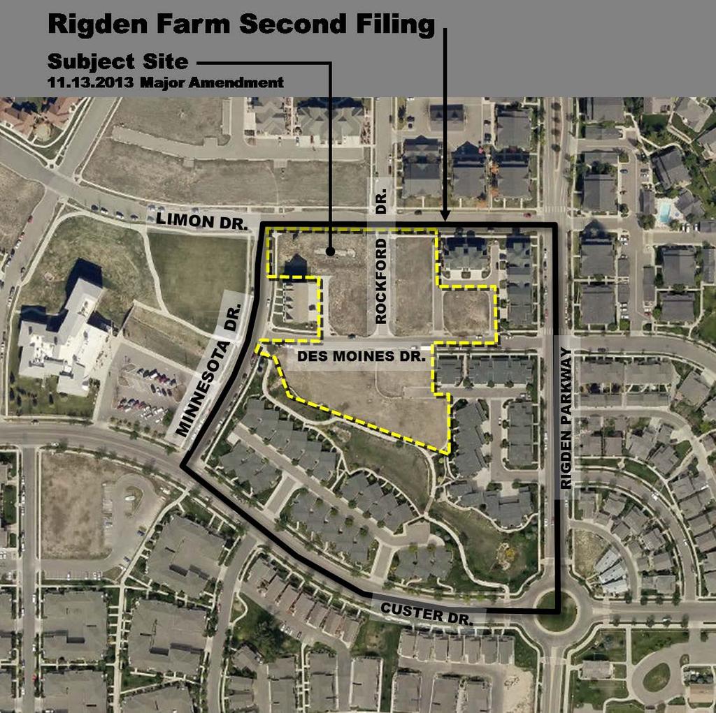
8 LaGrange at Rigden Farm Replat Major Amendment #MJA Administrative Hearing November 13, 2013 Page 5 FINDINGS OF FACT AND CONCLUSION: In evaluating the request for the LaGrange at Rigden Farm Replat Major Amendment, staff makes the following findings of fact: The Major Amendment complies with the process outlined in Article 2, Division 2.2 Common Development Review Procedures for Development Applications. The Major Amendment complies with relevant standards located in Article 3 General Development Standards. The Major Amendment complies with relevant standards located in Article 4, Division 4.5, Low Density Mixed Use Neighborhood. RECOMMENDATION: Staff recommends approval of the request for the Major Amendment to LaGrange at Rigden Farm Second Filing. ATTACHMENTS: 1 Aerial photo of Rigden Farm Second Filing with Subject Site 2 Plat 3 Site Plan 4 Landscape Plan 4a Landscape Plan Notes 5 Architectural Elevations 5a Exterior Finish Packages 6 Previously Approved Rigden Farm Second Filing Plat 7 Previously Approved Rigden Farm Second Filing Site and Landscape Plan 8 Previously Approved Rigden Farm Second Filing Architectural Elevations 9 Drainage Memo 10 Neighborhood Hearing Notice Letter
9
10
11
12 STATEMENT OF OWNERSHIP AND SUBDIVISION: CERTIFICATE OF DEDICATION: The Owner does hereby dedicate and convey to the City of Fort Collins, Colorado (hereafter City ), for public use, forever, a permanent right-of-way for street purposes and the Easements as laid out and designated on this Plat; provided, however, that (1) acceptance by the City of this dedication of Easements does not impose upon the City a duty to maintain the Easements so dedicated, and (2) acceptance by the City of this dedication of streets does not impose upon the City a duty to maintain streets so dedicated until such time as the provisions of the Maintenance Guarantee have been fully satisfied. The streets dedicated on this Plat are the fee property of the City as provided in Section C.R.S. The City's rights under the Easements include the right to install, operate, access, maintain, repair, reconstruct, remove and replace within the Easements public improvements consistent with the intended purpose of the Easements; the right to install, maintain and use gates in any fences that cross the Easements; the right to mark the location of the Easements with suitable markers; and the right to permit other public utilities to exercise these same rights. Owner reserves the right to use the Easements for purposes that do not interfere with the full enjoyment of the rights hereby granted. The City is responsible for maintenance of its own improvements and for repairing any damage caused by its activities in the Easements, but by acceptance of this dedication, the City does not accept the duty of maintenance of the Easements, or of improvements in the Easements that are not owned by the City. Owner will maintain the surface of the Easements in a sanitary condition in compliance with any applicable weed, nuisance or other legal requirements. Except as expressly permitted in an approved plan of development or other written agreement with the City, Owner will not install on the Easements, or permit the installation on the Easements, of any building, structure, improvement, fence, retaining wall, sidewalk, tree or other landscaping (other than usual and customary grasses and other ground cover). In the event such obstacles are installed in the Easements, the City has the right to require the Owner to remove such obstacles from the Easements. If Owner does not remove such obstacles, the City may remove such obstacles without any liability or obligation for repair and replacement thereof, and charge the Owner the City's costs for such removal. If the City chooses not to remove the obstacles, the City will not be liable for any damage to the obstacles or any other property to which they are attached. The rights granted to the City by this Plat inure to the benefit of the City's agents, licensees, permittees and assigns. OWNER: TITLE: STATE OF COLORADO ) )SS COUNTY OF LARIMER ) BY: The foregoing instrument was acknowledged before me this day of, 20, by, as of. Witness my hand and official seal My commission expires: Notary Public LIENHOLDER: TITLE: STATE OF COLORADO ) )SS COUNTY OF LARIMER ) BY: The foregoing instrument was acknowledged before me this day of, 20, by, as of. Witness my hand and official seal My commission expires: LAGRANGE AT RIGDEN FARM BEING A REPLAT OF LOTS 1, 3, 4, 5, 7,10 AND 15, RIGDEN FARM SECOND FILING, LOCATED IN THE NORTHWEST QUARTER OF SECTION 29, TOWNSHIP 7 NORTH, RANGE 68 WEST OF THE 6TH P.M., CITY OF FORT COLLINS, COUNTY OF LARIMER, STATE OF COLORADO Know all persons by these presents, that the undersigned owner(s) of the following described land: Lots 1, 3, 4, 5, 7, 10 and 15, Rigden Farm Second Filing, located in the Northwest Quarter of Section 29, Township 7 North, Range 68 West of the 6th P.M., City of Fort Collins, County of Larimer, State of Colorado, contains 97,108 square feet or acres per Rigden Farm Second Filing. For themselves and their successors in interest (collectively "Owner") have caused the above described land to be surveyed and subdivided into lots, tracts and streets as shown on this Plat to be known as LAGRANGE AT RIGDEN FARM (the "Development"), subject to all easements and rights-of-way now of record or existing or indicated on this Plat. The rights and obligations of this Plat shall run with the land. MAINTENANCE GUARANTEE: The Owner hereby warrants and guarantees to the City, for a period of two (2) years from the date of completion and first acceptance by the City of the improvements warranted hereunder, the full and complete maintenance and repair of the improvements to be constructed in connection with the Development which is the subject of this Plat. This warranty and guarantee is made in accordance with the City Land Use Code and/or the Transitional Land Use Regulations, as applicable. This guarantee applies to the streets and all other appurtenant structures and amenities lying within the rights-of-way, Easements and other public properties, including, without limitation, all curbing, sidewalks, bike paths, drainage pipes, culverts, catch basins, drainage ditches and landscaping. Any maintenance and/or repair required on utilities shall be coordinated with the owning utility company or department. The Owner shall maintain said improvements in a manner that will assure compliance on a consistent basis with all construction standards, safety requirements and environmental protection requirements of the City. The Owner shall also correct and repair, or cause to be corrected and repaired, all damages to said improvements resulting from development-related or building-related activities. In the event the Owner fails to correct any damages within thirty (30) days after written notice thereof, then said damages may be corrected by the City and all costs and charges billed to and paid by the Owner. The City shall also have any other remedies available to it as authorized by law. Any damages which occurred prior to the end of said two (2) year period and which are unrepaired at the termination of said period shall remain the responsibility of the Owner. REPAIR GUARANTEE: In consideration of the approval of this final Plat and other valuable consideration, the Owner does hereby agree to hold the City harmless for a five (5) year period, commencing upon the date of completion and first acceptance by the City of the improvements to be constructed in connection with the development which is the subject of this Plat, from any and all claims, damages, or demands arising on account of the design and construction of public improvements of the property shown herein; and the Owner furthermore commits to make necessary repairs to said public improvements, to include, without limitation, the roads, streets, fills, embankments, ditches, cross pans, sub-drains, culverts, walls and bridges within the right-of-way, Easements and other public properties, resulting from failures caused by design and/or construction defects. This agreement to hold the City harmless includes defects in materials and workmanship, as well as defects caused by or consisting of settling trenches, fills or excavations. Further, the Owner warrants that he/she owns fee simple title to the property shown hereon and agrees that the City shall not be liable to the Owner or his/her successors in interest during the warranty period, for any claim of damages resulting from negligence in exercising engineering techniques and due caution in the construction of cross drains, drives, structures or buildings, the changing of courses of streams and rivers, flooding from natural creeks and rivers, and any other matter whatsoever on private property. Any and all monetary liability occurring under this paragraph shall be the liability of the Owner. I further warrant that I have the right to convey said land according to this Plat. NOTICE OF OTHER DOCUMENTS: All persons take notice that the Owner has executed certain documents pertaining to this Development which create certain rights and obligations of the Development, the Owner and/or subsequent Owners of all or portions of the Development site, many of which obligations constitute promises and covenants that, along with the obligations under this Plat, run with the land. The said documents may also be amended from time to time and may include, without limitation, the Development Agreement, Site And Landscape Covenants, Final Site Plan, Final Landscape Plan, and Architectural Elevations, which documents are on file in the office of the clerk of the City and should be closely examined by all persons interested in purchasing any portion of the Development site. ATTORNEY'S CERTIFICATION I hereby certify that this Subdivision Plat has been duly executed as required pursuant to Section 2.2.3(C)(3)(a) through (e) inclusive of the Land Use Code of the City of Fort Collins and that all persons signing this Subdivision Plat on behalf of a corporation or other entity are duly authorized signatories under the laws of the State of Colorado. This Certification is based upon the records of the Clerk and Recorder of Larimer County, Colorado as of the date of execution of the Plat and other information discovered by me through reasonable inquiry and is limited as authorized by Section 2.2.3(C)(3)(f) of the Land Use Code. APPROVED AS TO FORM, CITY ENGINEER Attorney: Address: Registration No.: By the City Engineer of the City of Fort Collins, Colorado this day of A.D., 20. City Engineer PLANNING APPROVAL By the Director of Planning the City of Fort Collins, Colorado this day of A.D., 20. Director of Planning EAST DRAKE ROAD SURVEYOR'S STATEMENT SOUTH TIMBERLINE ROAD SOUTH TIMBERLINE ROAD CUSTER DRIVE KANSAS DR EAST DRAKE ROAD DR MINNESOTA LIMON DRIVE DES MOINES DR RIGDEN PKWY DES MOINES DENVER DR ANNELISE WAY DR TOPEKA LN CANBY WAY CHASE DRIVE CUSTER DRIVE WILLIAM NEAL PKWY COLORADO STATE UNIVERSITY ENVIRONMENTAL LEARNING CENTER I, Gerald D. Gilliland, a Colorado Registered Professional Land Surveyor do hereby state that this Subdivision Plat was prepared from an actual survey under my personal supervision, that the monumentation as indicated hereon were found or set as shown, and that the foregoing plat is an accurate representation thereof, all this to the best of my knowledge, information and belief. Gerald D. Gilliland Colorado Registered Professional Land Surveyor No NOTES: NOTICE SITE VICINITY MAP ALL RESPONSIBILITIES AND COSTS OF OPERATION, MAINTENANCE AND RECONSTRUCTION OF THE PRIVATE STREETS AND/OR DRIVES LOCATED ON THE PRIVATE PROPERTY THAT IS THE SUBJECT OF THIS PLAT SHALL BE BORNE BY THE OWNERS OF SAID PROPERTY, EITHER INDIVIDUALLY, OR COLLECTIVELY, THROUGH A PROPERTY OWNERS' ASSOCIATION, IF APPLICABLE. THE CITY OF FORT COLLINS SHALL HAVE NO OBLIGATION OF OPERATION, MAINTENANCE OR RECONSTRUCTION OF SUCH PRIVATE STREETS AND/OR DRIVES NOR SHALL THE CITY HAVE ANY OBLIGATION TO ACCEPT SUCH STREETS AND/OR DRIVES AS PUBLIC STREETS OR DRIVES. 1. Basis of Bearings is the south line of Lots 5 and 7, Rigden Farm Second Filing bearing North 90 00'00" West and monumented as shown on drawing. 2. All information regarding easements, rights-of-way or Title of Record, Northern Engineering relied upon Commitment Number, dated. VICINITY MAP {SCALE 1" = 1000'} 3. The lineal unit of measurement for this plat is U. S. Survey Feet. 4. The Rigden Farm Second Filing Development Agreement dated July 10, 2001 between the City and Rigden Farm, LLC shall apply to the property shown on this replat. ZEIGLER ROAD PROJECT: DATE: LAGRANGE AT RIGDEN FARM /9/13 SECTION: NOTICE: According to Colorado law you must commence any legal action based upon any defect in this survey within three years after you discover such defect. In no event may any action based upon any defect in this survey be commenced more than ten years after the date of the certificate shown hereon. TOWNSHIP: 29 7N N ORTHE RN E N G I N E E R I N G SCALE: CLIENT: N.A. N.A. RANGE: REVIEWED BY: G. Gilliland DRAWN BY: 68 W of the 6th PM PHONE: FAX: South College Avenue, Suite 10 Fort Collins, Colorado L. Smith SECTION 29, T7N, R68W CITY OF FORT COLLINS, COLORADO Notary Public Sheet 1 Of 2 Sheets
13 691.54' S00 07'25"E C9 C8 N29 31'51"E ' C11 FND NAIL & BRASS TAG LS #33642 FND YELLOW PLASTIC CAP LS # ' N53 01'58"W N00 33'25"E 71.66' C10 LAGRANGE AT RIGDEN FARM BEING A REPLAT OF LOTS 1, 3, 4, 5, 7, 10 AND 15, RIGDEN FARM SECOND FILING, LOCATED IN THE NORTHWEST QUARTER OF SECTION 29, TOWNSHIP 7 NORTH, RANGE 68 WEST OF THE 6TH P.M., CITY OF FORT COLLINS, COUNTY OF LARIMER, STATE OF COLORADO CURVE C1 C2 C3 C4 C5 C6 C7 C8 C9 C10 C11 C12 C13 C14 C15 C16 FND YELLOW PLASTIC CAP LS #33642 DELTA 58 02'06" 6 11'36" 6 14'56" 61 47'40" 33 18'47" 61 47'40" 36 48'54" 4 23'55" 86 57'44" 28 58'26" 90 00'00" 89 19'10" 90 00'00" 90 00'00" 90 00'00" 17 09'32" Curve Table RADIUS 32.50' ' 32.00' 9.50' 91.00' 9.50' ' ' 3.00' ' 3.00' 3.00' 15.00' 20.00' 20.00' ' C7 S89 26'35"E ' LENGTH 32.92' 46.02' 3.49' 10.25' 52.91' 10.25' ' 49.75' 4.55' ' 4.71' 4.68' 23.56' 31.42' 31.42' ' BEARING N47 08'18"W S86 54'10"E S03 07'50"E S30 46'25"W S45 00'51"W S59 15'18"W N71 26'25"W N55 13'55"W N13 57'01"W N15 02'38"E N45 33'25"E S44 47'00"E S45 00'00"W S45 00'00"W N45 00'00"W N10 36'29"E CHORD 31.53' 46.00' 3.49' 9.76' 52.17' 9.76' ' 49.73' 4.13' ' 4.24' 4.22' 21.21' 28.28' 28.28' ' FND YELLOW PLASTIC CAP LS #33642 FND YELLOW PLASTIC CAP LS #33642 FND YELLOW PLASTIC CAP LS #33642 LINE L1 L2 L3 L4 L ' N89 50'52"W FOUND MONUMENT DETAIL (1"=80') LINE TABLE LENGTH 10.00' 30.00' 30.00' 52.00' 25.00' C12 C5 C6 BEARING N90 00'00"E S00 00'00"E S89 26'35"E N90 00'00"E S00 00'00"E FND NAIL & BRASS TAG (ILLEGIBLE) C4 Delta= 85 07'05" R=10.00' L=14.86' Dir= N61 44'51"E Chord= 13.53' FOUND SCRIBED "X" IN CONCRETE Delta= 0 49'47" R=531.50' L=7.70' Dir= N19 36'12"E Chord= 7.70' N80 43'26"W 34.53' Delta= 90 00'00" R=3.00' L=4.71' Dir= N45 33'25"E Chord= 4.24' Delta= 1 28'22" R=531.50' L=13.66' Dir= N01 17'36"E Chord= 13.66' MINNESOTA DRIVE (63' ROW PER RIGDEN FARM 2nd FILING) C16 N00 33'25"E 71.66' 9' UE PER 2nd FILING N13 43'03"W 60.24' 23.27' ' 20.10' N00 00'00"E 66.56' U, D & AE 17.41' N90 00'00"W 98.24' (M) 98.14' (R) U, D & AE LOT 2 RIGDEN FARM SECOND FILING N33 38'27"E 53.00' N13 51'27"E 54.00' N49 39'38"W 51.94' S00 00'00"E 21.49' C1 U, D, A & EAE Delta= 14 18'24" R=425.50' L=106.25' Dir= S82 50'48"E Chord= ' C2 PAD 1 TO BE VACATED BY THIS PLAT 53.51' S89 26'35"E ' LOT sq.ft. N90 00'00"E N00 00'00"E ' 12' U, D & AE ' EXISTING LOT LINE TO BE VACATED BY THIS PLAT 12' 12.00' N00 00'00"E 93.13' 9' UE C13 TRACT A sq. ft. U, D, A & EAE PAD 3 TO BE VACATED BY THIS PLAT S76 08'33"E ' LOT sq.ft. N76 08'33"W ' U, D & AE 34.74' 22.74' N69 09'28"W ' TRACT A RIGDEN FARM SECOND FILING Delta= 89 26'35" R=10.00' L=15.61' Dir= S44 43'17"E Chord= 14.07' N90 00'00"E 25.19' N00 00'00"E ' 9' UE PER 2nd FILING N90 00'00"W 88.74' U, D & AE S00 00'00"E 25.02' Delta= 90 00'00" R=10.00' L=15.71' Dir= S45 00'00"W Chord= 14.14' N90 00'00"E ' N76 08'33"W ' 16.55' N90 00'00"E 12' U, D, A & EAE S00 00'01"W 65.20' 6' 6' PAD 10 TO BE VACATED BY THIS PLAT 11' L2 LOT sq.ft ' L5 S13 51'27"W 54.00' S, U, D & AE L3 U, D & AE 64.00' UE U,D&AE U,D,A&EAE S,U,D&AE (R) (M) 20.10' 65.14' 9' UE PER 2nd FILING 92.92' 40.00' S, U, D & AE L4 S00 00'00"E ' N36 52'27"E 67.36' N90 00'00"W 31.12' U, D & AE 85.24' EXISTING LOT LINE TO BE VACATED BY THIS PLAT TRACT C sq. ft. LEGEND S89 26'35"E 71.00' ROCKFORD DRIVE (51' ROW PER RIGDEN FARM 2nd FILING) 25.00' 9' UE PER 2nd FILING S00 00'00"E 46.56' 12' U, D, A & EAE C3 N00 00'00"E ' N13 51'27"E 54.00' EASEMENT LINE CENTERLINE BOUNDARY LINE RIGHT-OF-WAY LOT LINE FOUND CORNER AS DESCRIBED SET CORNER AS DESCRIBED UTILITY EASEMENT UTILITY, DRAINAGE & ACCESS EASEMENT UTILITY, DRAINAGE, ACCESS & EMERGENCY ACCESS EASEMENT SIGN, UTILITY, DRAINAGE & ACCESS EASEMENT RECORDED DISTANCE MEASURED DISTANCE Delta= 90 33'25" R=10.00' L=15.81' Dir= N45 16'42"E Chord= 14.21' S89 26'35"E 79.46' LOT sq.ft. 9' UE PER 2nd FILING 54.00' Delta= 90 00'00" R=10.00' L=15.71' Dir= N45 00'00"W Chord= 14.14' OUTLOT B RIGDEN FARM SECOND FILING U, D & AE Delta= 90 00'00" R=32.00' L=50.27' Dir= S45 00'00"E Chord= 45.25' 11' U, D, A & EAE S76 08'33"E ' LOT sq.ft. N76 08'33"W ' 53.91' EXISTING LOT LINE TO BE VACATED BY THIS PLAT N74 07'43"W ' S00 00'00"E ' N90 00'00"E ' PAD 15 TO BE VACATED BY THIS PLAT LIMON DRIVE (63' ROW PER RIGDEN FARM 2nd FILING) U, D & AE 25.55' N00 00'00"E ' PAD 4 TO BE VACATED BY THIS PLAT L1 U, D, A & EAE TRACT B sq.ft. LOT LINE TO BE VACATED BY THIS PLAT 15.55' 18.86' 36.86' S00 00'00"E 99.02' PAD 5 TO BE VACATED BY THIS PLAT 20' U, D, A & EAE 20.00' N90 00'00"W ' S13 51'27"W 54.00' N00 00'00"E 66.68' S44 34'15"E 32.53' N00 00'00"E 64.00' LOT 11 RIGDEN FARM SECOND FILING N12 40'00"E 45.14' C14 S00 00'00"E ' 11' 11' LOT 6 RIGDEN FARM SECOND FILING N90 00'00"E ' 57.34' PAD 7 TO BE VACATED BY THIS PLAT LOT sq.ft. BASIS OF BEARINGS SOUTH LINE OF LOTS 5 & 7 RIGDEN FARM 2nd FILING N90 00'00"W S90 00'00"E 95.42' LOT 14 RIGDEN FARM SECOND FILING U, D, A & EAE 95.42' U, D & AE S89 26'35"E ' C15 S00 00'00"E 64.00' N00 00'00"E 66.68' 10' 10.61' S00 00'00"E 97.68' 10' DES MOINES DRIVE (51' ROW PER RIGDEN FARM 2nd FILING) ( IN FEET ) 1 inch = 30ft. (US SURVEY FEET) NORTH LOT 8 RIGDEN FARM SECOND FILING LOT 9 RIGDEN FARM SECOND FILING Feet PROJECT: DATE: LAGRANGE AT RIGDEN FARM /9/13 SECTION: NOTICE: According to Colorado law you must commence any legal action based upon any defect in this survey within three years after you discover such defect. In no event may any action based upon any defect in this survey be commenced more than ten years after the date of the certificate shown hereon. TOWNSHIP: 29 7N N ORTHE RN E N G I N E E R I N G SCALE: CLIENT: N.A. N.A. Sheet 2 RANGE: REVIEWED BY: G. Gilliland DRAWN BY: 68 W of the 6th PM PHONE: FAX: South College Avenue, Suite 10 Fort Collins, Colorado L. Smith SECTION 29, T7N, R68W CITY OF FORT COLLINS, COLORADO Of 2 Sheets
14
15
16


17 Exterior Package A Lap Siding Shake Siding Trim Rockport Gray HC-105 Cormwell Gray HC-103 Monterey White HC-27 Door Color Kendall Charcoal HC Georgetown Cobble Ledge Door Style La Grange


18 Exterior Package B Lap Siding Shake Siding Trim Pittsfield Buff HC-24 Alexandria Beige HC-77 Monterey White HC-27 Door Color Kendall Charcoal HC Wolf Creek Ledgestone Door Style La Grange


19 Exterior Package C Lap Siding Shake Siding Trim Litchfield Gray HC-78 Davenport Tan HC-76 Monterey White HC-27 Door Color Kendall Charcoal HC Telluride Cobble Stone Door Style La Grange
20
Submittal Requirements: Subdivision Plat (Final)
") s Planning and Zoning Submittal Requirements: Subdivision Plat (Final) 1. Application form, APO fees, and filing fee. Transportation Development Review Fee please contact Engineering at (970) 221-6605
s Planning and Zoning Submittal Requirements: Subdivision Plat (Final) 1. Application form, APO fees, and filing fee. Transportation Development Review Fee please contact Engineering at (970) 221-6605
HARMONY & STRAUSS CABIN SUBDIVISION FILING NO. 1
 STATEMENT OF OWNERSHIP AND SUBDIVISION: KNOW ALL PERSONS BY THESE PRESENTS, THAT THE UNDERSIGNED OWNER(S) OF THE FOLLOWING DESCRIBED LAND: A PARCEL OF LAND BEING A PART OF THE WEST HALF OF SECTION 3, TOWNSHIP
E. 140TH AVE. VICINITY MAP SCALE: 1"=600' LAND USE TABLE NET AREA 599,946 SQFT AC. GROSS AREA 741,420 SQFT AC.
 SHEET OF PURPOSE STATEMENT: THIS PLAT IS INTENDED TO SUBDIVIDE. ACRES INTO SINGLE FAMILY ATTACHED LOTS, TRACTS, DEDICATE AND GRANT EASEMENTS. LEGAL DESCRIPTION: THE UNDERSIGNED BEING THE OWNER(S) OF A
Final Plat Mapping Requirements
 CURRENT PLANNING DIVISION 410 E. 5 th Street Loveland, CO 80537 970-962-2523 eplan-planning@cityofloveland.org cityofloveland.org/dc Final Plat Mapping Requirements All Final plats shall comply with the
VICINITY MAP/AERIAL MAP SITE
 VICINITY MAP/AERIAL MAP SITE N ZONING MAP PA 9 PA 5 SITE Solterra West ODP PA 7 N , DATE, 2013, TIME, COUNTY OF JEFFERSON, STATE OF COLORADO, $ DEDICATION CERTIFICATE THE UNDERSIGNED, BEING THE OWNER(S)
QUEBEC STREET EAST 130TH AVENUE ONEIDA STREET E. 130TH AVE. VALENTIA ST TAMARAC ST EAST 128TH AVENUE MONACO STREET BACHMAN DR. SITE QUINCE ST.
 SHEET OF CASE NO.: SUBA 0-0 PURPOSE STATEMENT: THIS PLAT IS INTENDED TO SUBDIVIDE. ACRES INTO 0 SINGLE FAMILY LOTS, AND TRACTS FOR PARKS, OPEN SPACE, DRAINAGE AND DETENTION, DEDICATE RIGHT-OF-WAY AND GRANT
FINAL PLAT. Community Development Department 8101 Ralston Road Arvada, Colorado 80002
 FINAL PLAT Community Development Department 8101 Ralston Road Arvada, Colorado 80002 September 2015 FINAL SUBDIVISION PLAT Final Subdivision Plat Review Applications for a Final Plat shall be submitted
MINOR SUBDIVISION PLAT
 MINOR SUBDIVISION PLAT Community Development Department 8101 Ralston Road Arvada, Colorado 80002 MINOR SUBDIVISION PLAT Subdivisions consisting of five (5) or fewer lots are eligible for the minor subdivision
MINOR SUBDIVISION PLAT
 MINOR SUBDIVISION PLAT Community Development Department 8101 Ralston Road Arvada, Colorado 80002 September 2015 MINOR SUBDIVISION PLAT Subdivisions consisting of five (5) or fewer lots are eligible for
QUEBEC STREET EAST 130TH AVENUE ONEIDA STREET E. 130TH AVE. VALENTIA ST TAMARAC ST EAST 128TH AVENUE MOACO STREET BACHMAN DR. SITE QUINCE ST.
 SHEET OF CASE NO.: SUBA - PURPOSE STATEMENT: THIS PLAT IS INTENDED TO SUBDIVIDE. ACRES INTO SINGLE FAMILY LOTS, AND TRACTS FOR PARKS, OPEN SPACE, DRAINAGE AND DETENTION, DEDICATE RIGHT-OF-WAY AND GRANT
COUNTY OF ADAMS, STATE OF COLORADO E. 40TH AVE. TOWER RD. E. 38TH AVE. SALIDA ST. HIGH LINE CANAL PROJECT LOCATION E. 32ND PKWY.
 LEGAL DESCRIPTION:, GATEWAY EAST AT TOWER SUBDIVISION FILING NO. 1, SAID PARCEL CONTAIN 598,154 SQUARE FEET OR MORE OR LESS GENERAL NOTES: 1. NOTICE: ACCORDING TO COLORADO LAW YOU MUST COMMENCE ANY LEGAL
Planning Commission Application Summary
 Planning Commission Application Summary Project Name: Academy Office Park Plat Amendment Request Address: 339 West 13490 South Current Zoning: CSD-DPMU Hearing Date: August 11, 2016 Summary of Request
APPENDIX C: PLAT SPECIFICATIONS AND CERTIFICATES
 APPENDIX C: PLAT SPECIFICATIONS AND CERTIFICATES A. Drawing. All plats for recording must be submitted on photographically reproducible and dimensionally stable polyester sheets such as Mylar, Cronar or
PLANNING DIRECTOR. Approved by the Planning Director on this day of, A.D. 20. day of, A.D. 20. Approved by the Fire Chief on this
 Located in a portion of the West Half of Section 19, Township 5 South, Range 1 East, Salt Lake Base and Meridian. SURVEYOR'S CERTIFICATE I, the undersigned surveyor, do hereby certify that I am a registered
FINAL PLAT APPLICATION
 FINAL PLAT APPLICATION (Page 1 of 3) LEGAL OWNER(s): NAME: STREET ADDRESS OWNER(s): CITY, STATE, ZIP CODE: PHONE NUMBER: BILLING ADDRESS: NAME OF ENGINEER/SURVEYOR: Engineer/Surveyor Address, Phone: PROPERTY
ABBREVIATION LEGEND SITE INFORMATION:
 SITE INFORMATION: Current Zone: R-3 PUD, governed by Fox Hollow 2nd MDA Basis of Elevations: Northeast Corner of Section 13, T6S, R1W, S.L.B. & M Elevation: 4599.26 (Benchmark) ABBREVIATION LEGEND Owners:
City of Melissa, Texas Plat Dedication Language
 City of Melissa, Texas Plat Dedication Language [INCLUDE THE FOLLOWING DEDICATION LANGUAGE FOR INDIVIDUALS (MODIFY APPROPRIATELY TO REFLECT EXACTLY AS SHOWN ON PROPERTY DEED)]: NOW THEREFORE, KNOW ALL
AGENDA ITEM G-2 Public Works
 AGENDA ITEM G-2 Public Works STAFF REPORT City Council Meeting Date: 2/23/2016 Staff Report Number: 16-035-CC Consent Calendar: Adopt a resolution accepting Easements and approving the abandonment of two
EASEMENT AGREEMENT. WHEREAS, Ferguson is the 100% owner of the property described on Exhibit B attached hereto (the Williams Property );
;") EASEMENT AGREEMENT THIS EASEMENT AGREEMENT ( Agreement ) is entered into as of this day of, 2016, by and between CRAIG FERGUSON ( Ferguson ), and MAMIE DAVIS and JERRY MOORE ( Davis & Moore ), whose legal
EASEMENT AGREEMENT THIS EASEMENT AGREEMENT ( Agreement ) is entered into as of this day of, 2016, by and between CRAIG FERGUSON ( Ferguson ), and MAMIE DAVIS and JERRY MOORE ( Davis & Moore ), whose legal
RULES, REGULATIONS AND REQUIREMENTS RELATING TO THE APPROVAL AND ACCEPTANCE OF IMPROVEMENTS IN SUBDIVISIONS OR RE-SUBDIVISIONS
 GALVESTON COUNTY RULES, REGULATIONS AND REQUIREMENTS RELATING TO THE APPROVAL AND ACCEPTANCE OF IMPROVEMENTS IN SUBDIVISIONS OR RE-SUBDIVISIONS GALVESTON COUNTY ENGINEERING DEPARTMENT MARCH 3, 1997 Amendment
65.00 Right-of-Way, Easements, Subordination Agreements and Licenses
 65.00 Subordination Agreements and Licenses Right-of-way, easements, subordination agreements and licenses are located as follows: Subject Name Page Number Single Lot Development... 65.00-1 Subdivision
VICINITY MAP SCALE 1'' = 2000'
 CITY CREEK ANNEXATION TO THE CITY OF THORNTON LOCATED IN THE SOUTHWEST QUARTER OF SECTION 11 AND THE WEST HALF OF SECTION 14, TOWNSHIP 1 SOUTH, RANGE 68 WEST OF THE 6TH PRINCIPAL MERIDIAN, COUNTY OF ADAMS,
SUBMITTAL REQUIREMENTS: The number indicates the number of copies for submittal (if applicable).
.") Office Use Only Preliminary Long Plat Long Subdivision Applicant Checklist PLANNING, COMMUNITY, & ECONOMIC DEVELOPMENT DEPARTMENT PRELIMINARY LONG PLAT LONG SUBDIVISION CHECKLIST Mailing Address: P.O.
Office Use Only Preliminary Long Plat Long Subdivision Applicant Checklist PLANNING, COMMUNITY, & ECONOMIC DEVELOPMENT DEPARTMENT PRELIMINARY LONG PLAT LONG SUBDIVISION CHECKLIST Mailing Address: P.O.
Innsbruck Val Moritz AFP of Lot 46, Lot 47, & Amended Lot 48 Block 17 Amended Final Plat Adjustment of Interior Lot Lines
 Innsbruck Val Moritz AFP of Lot 46, Lot 47, & Amended Lot 48 Block 17 Amended Final Plat Adjustment of Interior Lot Lines APPLICATION: AMENDED FINAL PLAT HEARING DATES: Planning Commission: 8 November
PLANNING COMMISSION REPORT Non-Public Hearing Item
 PC Staff Report 09/21/2015 Item No. 2B - 1 PLANNING COMMISSION REPORT Non-Public Hearing Item PC Staff Report 09/212015 ITEM NO. 2B: FINAL PLAT FOR MORGAN ADDITION; 800 MONTEREY WAY (MKM) : Consider a
AGENDA HAYDEN PLANNING COMMISSION
 AGENDA HAYDEN PLANNING COMMISSION THURSDAY, DECEMBER 14, 2017 7:00 P.M. HAYDEN TOWN HALL 178 WEST JEFFERSON AVENUE REGULAR MEETING 1. CALL TO ORDER, MOMENT OF SILENCE & PLEDGE OF ALLEGIANCE 2. ROLL CALL
City of Edmonds TEMPORARY CONSTRUCTION EASEMENT
 City of Edmonds TEMPORARY CONSTRUCTION EASEMENT Madrona Elementary Walkway Property Address: 9300 236 th St SW. Edmonds, WA 98020 Assessor s Property Tax Parcel No.: 27033600404600 Property Owner: Edmonds
SUBDIVISION APPLICATION
 STAFF USE ONLY Date Submitted: Received by: Fee paid: Project # REQUIRED SUBMITTALS Application Fee: $600.00 (up to 5 lots) + $50.00 (per lot above 5) Publication Fee: $300.00 Mailing Fee: $6.00 per hearing
GREENWAY EASEMENT AGREEMENT
 GREENWAY EASEMENT AGREEMENT This greenway access easement is entered into by and between the Laramie County School District Number One ( Grantor ), a corporate body organized under the laws of the State
The Filing Fee for a Minor Plat is $ PLUS $20.00 per lot created
 DEPARTMENT OF COMMUNITY DEVELOPMENT MINOR PLAT PROCEDURE The Filing Fee for a Minor Plat is $250.00 PLUS $20.00 per lot created Description: The purpose of a Minor Plat is to allow property to be platted
SUBMITTAL REQUIREMENTS: The number indicates the number of copies for submittal (if applicable).
.") Office Use Only Preliminary Long Plat Long Subdivision Applicant Checklist PLANNING, COMMUNITY, & ECONOMIC DEVELOPMENT DEPARTMENT FINAL LONG PLAT LONG SUBDIVISION CHECKLIST Mailing Address: P.O. Box 547,
Office Use Only Preliminary Long Plat Long Subdivision Applicant Checklist PLANNING, COMMUNITY, & ECONOMIC DEVELOPMENT DEPARTMENT FINAL LONG PLAT LONG SUBDIVISION CHECKLIST Mailing Address: P.O. Box 547,
City of Lakewood Plat Specifications
 City of Lakewood Plat Specifications Revised 12/15/2015 Plat Checklist.1 Notes, Certifications and Acknowledgements..5 Electronic Submittal Information... 20 Sheet Layout.21 A Professional Land Surveyor,
STANDARDIZED LEGAL DESCRIPTIONS AND EXHIBITS
 STANDARDIZED LEGAL DESCRIPTIONS AND EXHIBITS Public Works Department, Engineering Division June 14, 2004 UNIFIED GOVERNMENT STANDARDIZED LEGAL DESCRIPTIONS AND EXHIBITS For: Roads, Bridges, Short Span
EASEMENT AGREEMENT. hereinafter called Grantor, (whether grammatically singular or plural) and the:
 and the:") EASEMENT AGREEMENT THIS EASEMENT AGREEMENT, made and entered into as of the day of,, by and between: hereinafter called Grantor, (whether grammatically singular or plural) and the: hereinafter called Distributor.
EASEMENT AGREEMENT THIS EASEMENT AGREEMENT, made and entered into as of the day of,, by and between: hereinafter called Grantor, (whether grammatically singular or plural) and the: hereinafter called Distributor.
Memorandum September 13, 2018
 Memorandum September 13, 2018 TO: FROM: Planning and Zoning Commission Julie Couch, Town Manager Israel Roberts, AICP Planning Manager SUBJECT: FINAL PLAT FOR THE EBERSOHL ADDITION BACKGROUND: This is
PART OF SECTION 9, TOWNSHIP 36 NORTH, RANGE 9 EAST OF THE THIRD PRINCIPAL MERIDIAN, NORTH OF THE INDIAN BOUNDRY LINE, IN WILL COUNTY, ILLINOIS.
 PART OF SECTION 9, TOWNSHIP 6, RANGE 9 EAST OF THE THIRD PRINCIPAL MERIDIAN, OF THE INDIAN BOUNY LINE, IN WILL COUNTY, ILLINOIS. ASSUMED THE LINE OF THE WEST / OF SECTION 9-6-9 TO BE: S89 5' 7"E 60 0 0
SUBDIVISION APPLICATION
 SUBDIVISION APPLICATION City of Horn Lake Planning Department 3101 Goodman Road, W Horn Lake, MS 38637 662-342-3559 Fax: 662-342-3485 Applications due the 1st working day of the month. Submit application
Synergy Park Addition (Companion to item 3)
") Synergy Park Addition (Companion to item 3) Attachments: 1. Locator 2. Replat staff report 3. Replat W P G r es rg eo e s Bu hh wy Lot 6A 4.02-acres Lot 4C 13.02-acres Fran k Lots 4C and 6A, Block A Synergy
Synergy Park Addition (Companion to item 3) Attachments: 1. Locator 2. Replat staff report 3. Replat W P G r es rg eo e s Bu hh wy Lot 6A 4.02-acres Lot 4C 13.02-acres Fran k Lots 4C and 6A, Block A Synergy
PERPETUAL DRAINAGE EASEMENT
 PERPETUAL DRAINAGE EASEMENT THIS GRANT OF PERPETUAL DRAINAGE EASEMENT is made this day of, 2016, between [name and address] ("Grantor"), and the City of Thornton, a Colorado municipal corporation, located
New Jersey Administrative Code Title 13, Chapter 40 State Board of Professional Engineers and Land Surveyors
 New Jersey Administrative Code Title 13, Chapter 40 State Board of Professional Engineers and Land Surveyors SUBCHAPTER 1. TITLE BLOCKS AND SEALS FOR PROFESSIONAL ENGINEERS AND LAND SURVEYORS 13:40-1.1
STANDARD LANGUAGE FORMAT GUIDE PLANNING SERVICES DIVISION
 A. OWNERSHIP CERTIFICATE The purpose of the ownership certificate is to identify the owner and provide the Volume and Page of Deed Records, verifying the ownership. When the property owner is a corporation,
PROPERTY EXCHANGE & CONVEYANCE AGREEMENT RECITALS
 PROPERTY EXCHANGE & CONVEYANCE AGREEMENT This Property Exchange and Conveyance Agreement ( Agreement ) is entered into as of the date of execution by and between Laramie Church of Christ, Inc., a Wyoming
CITY OF SARALAND FINAL SUBDIVISION PLAT REVIEW
 CITY OF SARALAND FINAL SUBDIVISION PLAT REVIEW Application Number: Date Plat Submitted: Name of Subdivision: Name of Owner: Owner Address: (Street or P.O. Box) Telephone #: (City) (State) (Zip) E-mail:
TOWN OF BOONSBORO DEPARTMENT OF PLANNING, ZONING & ENGINEERING
 TOWN OF BOONSBORO DEPARTMENT OF PLANNING, ZONING & ENGINEERING WWW.TOWN.BOONSBORO.MD.US 301-432-5690 PLAN CHANGE: SYCAMORE RUN RETAINING WALL, DRAINAGE, AND GRADING ALTERATIONS STAFF REPORT May 17, 2018
SIDEWALK ACCESS EASEMENT AGREEMENT
 SIDEWALK ACCESS EASEMENT AGREEMENT THIS SIDEWALK ACCESS EASEMENT AGREEMENT ( Agreement ) is made by and among WATERWALK PLACE OWNERS ASSOCIATION, a Kansas non-profit corporation ( WWP ), FOUR-G, LLC, a
DEED AND DEDICATION FOR PUBLIC RIGHT OF WAY
 TO : BOARD OF DIRECTORS FROM : GARY PLATT, EXEC. DIRECTOR BUSINESS AND OPERATIONS SUBJECT : CITY OF STANWOOD CONSTRUCTION EASEMENT AND RIGHT-OF-WAY DEDICATION DATE : MARCH 17, 2009 TYPE : ACTION NEEDED
Appendix A - REQUIRED PLAT CERTIFICATES... A-1
 APPENDICES CONTENTS: Appendix A - REQUIRED PLAT CERTIFICATES... A-1 Appendix B - MINIMUM STREET IMPROVEMENT STANDARDS Standard 1A Minor Residential... B-1 Standard 1B Minor Residential... B-2 Standard
REQUIREMENTS For Subdivision Plats, Administrative Subdivision Plats, Deposit Surveys and Deeds December 2016
 REQUIREMENTS For Subdivision Plats, Administrative Subdivision Plats, Deposit Surveys and Deeds December 2016 General Requirements - All plats shall have the information necessary to delineate and reestablish
RIGHT OF WAY AND COMMON DRIVEWAY AGREEMENT SUN8 PDC, LLC, c/o DISTRIBUTED SUN, LLC SUBDIVISION DRYDEN, NEW YORK
 RIGHT OF WAY AND COMMON DRIVEWAY AGREEMENT SUN8 PDC, LLC, c/o DISTRIBUTED SUN, LLC SUBDIVISION DRYDEN, NEW YORK THIS RIGHT OF WAY AGREEMENT ( Agreement ) is made this day of, 2017 by SCOTT PINNEY, an individual
Sketch & Legal Description of Mitigation Bank and Ingress/Egress Access Easements
 Appendix H: Sketch & Legal Description of Mitigation Bank and Ingress/Egress Access Easements Tippen Bay Wetland Mitigation Bank DeSoto County, Florida Prepared by: September, 2017 Original file
CITY OF ELK GROVE CITY COUNCIL STAFF REPORT
 CITY OF ELK GROVE CITY COUNCIL STAFF REPORT AGENDA ITEM NO. 8.22 AGENDA TITLE: Adopt resolution granting the Sacramento Area Sewer District (SASD) an easement for sewer and incidental purposes over City-owned
NOT TO BE SUBMITTED WITH SKETCH DESIGN APPROVAL Subdivision Checklist: Major Subdivision Final Plat
 Must be received with review fee (equal to $200.00, plus $25.00 per lot) no later than 15 days prior to Planning Board meeting, which is normally the first Monday of the month (certain holidays may modify
CHAPTER 2 RELATED DOCUMENTS AND FORMS
 CHAPTER 2 RELATED DOCUMENTS AND FORMS TABLE OF CONTENTS CHAPTER 2 RELATED DOCUMENTS AND FORMS Resolution R00- Establishing Public Improvement Design Standards Page 1 Current Plans Review & Construction
A Final Plat will be reviewed concurrently with any other development review application(s) that is required.
 that is required.") RELATED FACTS TO KNOW: Adams County Recording Requirements, Annexation, Common Wall Subdivision, Development Plan (PUD Development Permit), Fees, Helpful Contact Information, Lot Line Adjustment, Neighborhood
RELATED FACTS TO KNOW: Adams County Recording Requirements, Annexation, Common Wall Subdivision, Development Plan (PUD Development Permit), Fees, Helpful Contact Information, Lot Line Adjustment, Neighborhood
Honorable Mayor Bill Agan and members of the Richland Hills City Council. Final Plat Richland Hills, Lots 1 & 2, Block 1 Brumlow Addition
 2B - 1 Memorandum To: From: Date: Subject: Honorable Mayor Bill Agan and members of the Richland Hills City Council Jason Moore, Assistant City Manager January 17, 2017 Final Plat Richland Hills, Lots
EASEMENT AGREEMENT. WHEREAS, Hall Brothers owns certain real property located in Weber County, Utah ( Hall Brothers Property );
;") When Recorded Return to: Parcel No. EASEMENT AGREEMENT THIS EASEMENT AGREEMENT ( Agreement ) is entered into this day of, 2016 by and between VALLEY DREAMS PROPERTIES, LLC, a Utah limited liability company
When Recorded Return to: Parcel No. EASEMENT AGREEMENT THIS EASEMENT AGREEMENT ( Agreement ) is entered into this day of, 2016 by and between VALLEY DREAMS PROPERTIES, LLC, a Utah limited liability company
OWNERS ACKNOWLEDGMENT
 OWNERS ACKNOWLEDGMENT STATE OF TEXAS COUNTY OF GALVESTON/HARRIS I (or we), (name of owner or owners) acting by and through (name and title of officer) being officers of (name of company or corporation),
AGREEMENT FOR TEMPORARY CONSTRUCTION EASEMENT AND PERMANENT SEWER UTILITY EASEMENT
 AGREEMENT FOR TEMPORARY CONSTRUCTION EASEMENT AND PERMANENT SEWER UTILITY EASEMENT This Agreement for Temporary Construction Easement and Permanent Sewer Utility Easement (hereinafter the "Agreement")
Preliminary Subdivision Application (Major) (Four (4) lots or more)
 (Four (4) lots or more)") Gunnison City Offices www.gunnisoncity.org 38 West Center Gunnison, Utah 84634 (435) 528 7969 Date of Application: Preliminary Subdivision Application (Major) (Four (4) lots or more) APPLICANT INFORMATION
Gunnison City Offices www.gunnisoncity.org 38 West Center Gunnison, Utah 84634 (435) 528 7969 Date of Application: Preliminary Subdivision Application (Major) (Four (4) lots or more) APPLICANT INFORMATION
CERTIFIED SURVEY MAP
 SCONSIN STATE PLANE N:389676.12 E:2130390.15 Center of Section 23 CERTIFIED SURVEY MAP 734.06' THE (PRITCHETTE) ORIGINAL PLAT OF ALL IN THE NW 1 4 OF THE SE 1 4 OF FRACTIONAL SECTION 23, T7N, R9E, IN THE
SUBDIVISION APPLICATION
 SUBDIVISION APPLICATION Preliminary Plat Minor Plat Final Plat Amended Plat Applicant Name: Owner (if different from applicant) Name: Company: Company: Address: Address: City, State, Zip City, State, Zip
We Appreciate Your Business and Look Forward to Serving You in the Future.
 Stewart Title Guaranty Company Commercial Services (Denver) 55 Madison Street, Suite 400 Denver, CO 80206 Date: October 31, 2017 File Number: 15000310384- Amendment No. 7 Property: Tracts A thru F Stargate
USE BY SPECIAL REVIEW HOULIHAN PIPELINE PROJECT 5 OF 6 6 OF 6 E. CO RD 6 / E. 6TH AVE. S. CO RD113 / S. MANILLA RD.
 USE BY SPECIAL REVIEW LOCATED IN SECTIONS, 4,,, &, TOWNSHIP 4 SOUTH RANGE 64 WEST OF THE 6TH P.M. 1 4 STANDARD NOTES THE OPERATOR, OF THE PROJECT KNOWN AS, THEIR RESPECTIVE SUCCESSORS, HEIRS AND/OR ASSIGNS
MINOR SUBDIVISION PLAT CHECKLIST
 MINOR SUBDIVISION PLAT CHECKLIST Project Name: Tax ID #: Project Number: Date: _ Reviewed By: Telephone: NOTES: All lots on septic systems must comply with the Fulton County Health Department requirements
A lot line or terminology adjustment will be reviewed concurrently with any other development review application(s) that are required.
 that are required.") RELATED FACTS TO KNOW: Adams County Recording Requirements, Annexation, Common Wall Subdivision, Development Plan (PUD Development Permit), Fees, Helpful Contact Information, Neighborhood Meeting, Park
RELATED FACTS TO KNOW: Adams County Recording Requirements, Annexation, Common Wall Subdivision, Development Plan (PUD Development Permit), Fees, Helpful Contact Information, Neighborhood Meeting, Park
DECLARATION OF DRAINAGE EASEMENTS. Document No. Document Title. (Declarant) Recording Data Return Address
 Recording Data Return Address") Document No. DECLARATION OF DRAINAGE EASEMENTS Document Title (Declarant) Recording Data Return Address DOCUMENT PREPARED BY AND AFTER RECORDING RETURN TO: Parcel No. - - - - - - DECLARATION OF DRAINAGE
Document No. DECLARATION OF DRAINAGE EASEMENTS Document Title (Declarant) Recording Data Return Address DOCUMENT PREPARED BY AND AFTER RECORDING RETURN TO: Parcel No. - - - - - - DECLARATION OF DRAINAGE
FINAL PLAT GUIDE TO SUBDIVIDING PROPERTY. Background
 FINAL PLAT GUIDE TO SUBDIVIDING PROPERTY Background A final plat is the second step in the process of subdividing land into separate parcels for future sale or lease. Once a preliminary plat has been approved
PERMANENT EASEMENT AGREEMENT. good and valuable consideration, the sufficiency and receipt of which is hereby acknowledged, The Esther Harrison
 PERMANENT EASEMENT AGREEMENT For and in consideration of the sum of Seven thousand thirty and 00/100 dollars ($7,030.00) and other good and valuable consideration, the sufficiency and receipt of which
DECLARATION OF RECIPROCAL ACCESS AND UTILITY EASEMENTS
 ITEM 175-2701-C0517 Page 1 of 6 Return to: Grant Road LLC 1430 Country Manor Boulevard, Suite 3 Billings, MT 59102 DECLARATION OF RECIPROCAL ACCESS AND UTILITY EASEMENTS This Reciprocal Easement Declaration
CITY AND COUNTY OF BROOMFIELD SUBDIVISION IMPROVEMENT AGREEMENT FOR (PROPERTY NAME - ALL CAPS)
") CITY AND COUNTY OF BROOMFIELD SUBDIVISION IMPROVEMENT AGREEMENT FOR (PROPERTY NAME - ALL CAPS) THIS AGREEMENT, made and entered into this day of, 20, by and between The CITY AND COUNTY OF BROOMFIELD, a
CITY AND COUNTY OF BROOMFIELD SUBDIVISION IMPROVEMENT AGREEMENT FOR (PROPERTY NAME - ALL CAPS) THIS AGREEMENT, made and entered into this day of, 20, by and between The CITY AND COUNTY OF BROOMFIELD, a
GENERAL WARRANTY DEED
 PROJECT. # 89008160 TRACT NO.:10 PARCEL ID NO.:PL199032200000001003 OWNERS NAME: Park Hill School District SITUS ADDRESS:5520 N. Northwood: KANSAS CITY, MISSOURI MAILING ADDRESS:7703 NW Barry Rd. Kansas
CERTIFICATE OF APPROVAL OF COUNTY COMMISSION
 STATE OF FLORIDA COUNTY OF PINELLAS CERTIFICATE OF APPROVAL OF COUNTY COMMISSION It is hereby certified that this plat has been officially approved for record by the Board of County Commissioners of the
COUNCIL AGENDA MEMO ITEM NO. III - #1
 COUNCIL AGENDA MEMO ITEM NO. III - #1 FROM: Anton Jelinek, Director of Utilities MEETING: October 24, 2017 SUBJECT: PRESENTER: Permanent Utility and Right-of-Way Easement Anton Jelinek Discussion: At the
Cross Reference: Instrument No. A State Parcel No Parcel: TEMPORARY CONSTRUCTION EASEMENT AGREEMENT
 Cross Reference: Instrument No. A199500066899 Project: 92TU000128 State Parcel No. 49-07-18-107-004.000-801 Parcel: 8033304 Date: Version: TEMPORARY CONSTRUCTION EASEMENT AGREEMENT THIS TEMPORARY CONSTRUCTION
City of Fort Lupton Amended Plat Process
 City of Fort Lupton Amended Plat Process Purpose The Amended Plat process is an administrative process to amend a recorded Plat. An Amended Subdivision is an administrative revision to a recorded Subdivision
Oakland County Michigan Register of Deeds Plat Engineering, GIS, & Remonumentation Dept. Ph: (248) Fax (248)
 Fax (248)") Oakland County Michigan Register of Deeds Plat Engineering, GIS, & Remonumentation Dept. Ph: (248)-858-1447 Fax (248)-858-7466 Requirements Needed for Final Plat Approval No. General Requirements. 1 Routing
Oakland County Michigan Register of Deeds Plat Engineering, GIS, & Remonumentation Dept. Ph: (248)-858-1447 Fax (248)-858-7466 Requirements Needed for Final Plat Approval No. General Requirements. 1 Routing
CHAPTER 26 PLANNING AND ZONING ARTICLE VII. MOBILE HOMES AND RECREATIONAL VEHICLE (RV) PARKS. Recreational Vehicle (RV) Park Development Standards
 PARKS. Recreational Vehicle (RV) Park Development Standards") CHAPTER 26 PLANNING AND ZONING ARTICLE VII. MOBILE HOMES AND RECREATIONAL VEHICLE (RV) PARKS. Section 26-VII-1. Section 26-VII-2. Section 26-VII-3. Section 26-VII-4. Section 26-VII-5. Purpose Permitted
CHAPTER 26 PLANNING AND ZONING ARTICLE VII. MOBILE HOMES AND RECREATIONAL VEHICLE (RV) PARKS. Section 26-VII-1. Section 26-VII-2. Section 26-VII-3. Section 26-VII-4. Section 26-VII-5. Purpose Permitted
DIVISION 2 - CONSTRUCTION PLAN AND MISCELLANEOUS REQUIREMENTS
 DIVISION 2 - CONSTRUCTION PLAN AND MISCELLANEOUS REQUIREMENTS 2.1 Required Plan Sheets 2.2 Drawing Requirements 2.3 Graphic Standards 2.4 Easements 2.5 Utility Locations 2.6 Private Facility Locations
WATERFORD LANDING COMMUNITY DEVELOPMENT DISTRICT REGULAR MEETING AGENDA
 WATERFORD LANDING COMMUNITY DEVELOPMENT DISTRICT REGULAR MEETING AGENDA January 31, 2019 Waterford Landing Community Development District OFFICE OF THE DISTRICT MANAGER 2300 Glades Road, Suite 410W Boca
ADMINISTRATIVE HEARING STAFF REPORT Country Club Acres Second Amended Subdivision Amendment PLNSUB E Parkway Avenue December 12, 2013
 ADMINISTRATIVE HEARING STAFF REPORT Country Club Acres Second Amended Subdivision Amendment PLNSUB2013-00925 2167 E Parkway Avenue December 12, 2013 Planning Division Department of Community & Economic
PERMANENT EASEMENT AGREEMENT
 PERMANENT EASEMENT AGREEMENT This Permanent Easement Agreement ("Agreement") effective this day of, 2016, by and between Goin Straight, LLC, a Colorado limited liability company (Grantor"), whose mailing
PRELIMINARY PLAT Checklist
 PRELIMINARY PLAT Checklist 3715 Bridgeport Way W University Place, WA 98466 PH: (253) 566-5656 FAX: (253) 460-2541 This is a checklist of materials required for a Preliminary Plat. This checklist is provided
Recitals. WHEREAS, Grantor owns real property ("Property"), under which Improvements (as defined in Section 1 below) will pass; and
, under which Improvements (as defined in Section 1 below) will pass; and") EASEMENT AGREEMENT This Easement Agreement ("Agreement") effective this 24 th day of April, 2017, by and between YMCA Community Campus, LLC, whose address is 3200 Spaulding Avenue, Pueblo, CO 81008 ( Grantor
EASEMENT AGREEMENT This Easement Agreement ("Agreement") effective this 24 th day of April, 2017, by and between YMCA Community Campus, LLC, whose address is 3200 Spaulding Avenue, Pueblo, CO 81008 ( Grantor
Preliminary Subdivision Application (Minor) (Three (3) lots or less)
 (Three (3) lots or less)") Gunnison City Offices www.gunnisoncity.org 38 West Center Gunnison, Utah 84634 (435) 528 7969 Date of Application: Preliminary Subdivision Application (Minor) (Three (3) lots or less) APPLICANT INFORMATION
Gunnison City Offices www.gunnisoncity.org 38 West Center Gunnison, Utah 84634 (435) 528 7969 Date of Application: Preliminary Subdivision Application (Minor) (Three (3) lots or less) APPLICANT INFORMATION
COVENANT AGREEMENT BETWEEN THE CITY OF RAPID CITY AND GWH PROPERTIES, LLC TO PERMIT CERTAIN ENCROACHMENTS IN PEDESTRIAN AND UTILITY EASEMENT
 PREPARED BY: City Attorney s Office 300 Sixth Street Rapid City, SD 57702 (605) 394-4140 COVENANT AGREEMENT BETWEEN THE CITY OF RAPID CITY AND GWH PROPERTIES, LLC TO PERMIT CERTAIN ENCROACHMENTS IN PEDESTRIAN
EASEMENT AGREEMENT. hereinafter called Grantor, (whether grammatically singular or plural) and the:
 and the:") EASEMENT AGREEMENT THIS EASEMENT AGREEMENT made and entered into as of the day of,, by and between: hereinafter called Grantor, (whether grammatically singular or plural) and the: hereinafter called Distributor.
EASEMENT AGREEMENT THIS EASEMENT AGREEMENT made and entered into as of the day of,, by and between: hereinafter called Grantor, (whether grammatically singular or plural) and the: hereinafter called Distributor.
I. Requirements for All Applications. C D W
 108-16.1. Application checklists. Checklist for Required Submissions to the Planning Board or Zoning Board of Adjustment of Monroe Township All required submissions are to be made to the Administrative
FIFTH AMENDMENT OF DECLARATION OF DEED RESTRICTIONS AND DEDICATIONS FOR PINEHURST ESTATES (A Clatsop County, Oregon Subdivision)
") After Recording Return To: W. Louis Larson 990 Astor Street Astoria, OR 97103 FIFTH AMENDMENT OF DECLARATION OF DEED RESTRICTIONS AND DEDICATIONS FOR PINEHURST ESTATES (A Clatsop County, Oregon Subdivision)
After Recording Return To: W. Louis Larson 990 Astor Street Astoria, OR 97103 FIFTH AMENDMENT OF DECLARATION OF DEED RESTRICTIONS AND DEDICATIONS FOR PINEHURST ESTATES (A Clatsop County, Oregon Subdivision)
Easements, Establishments, Abandonments and Vacations
 Easements, Establishments, Abandonments and Vacations A highway easement conveys, in perpetuity, the right to construct and maintain a highway facility on the land of the fee holder. (Property owner) The
SUBDIVISION APPLICATION: RECOMBINATION PLAT or EXEMPT PLAT
 SUBDIVISION APPLICATION: RECOMBINATION PLAT or EXEMPT PLAT Pursuant to Article 7, Section 155.706 of the Unified Development Code, an owner of land within the jurisdiction of the Town (or a duly authorized
SECTION 6 - APPROVAL OF PLATS. Whenever any subdivision of land is proposed, and before any permit for the
 SECTION 6 - APPROVAL OF PLATS 6-1 APPROVAL REQUIRED BEFORE SALE Whenever any subdivision of land is proposed, and before any permit for the erection of a structure shall be granted, the subdivider or his
INSTRUCTIONS FINAL PLAT APPROVAL APPLICATION
 INSTRUCTIONS FINAL PLAT APPROVAL APPLICATION 1. The applicant/agent shall fill out the attached application. The attached application form must be completely filled in before it can be filed. Portions
(b) Monumentation of land surveys [ (1) (a)]. For the words, any line points or reference points which are set to perpetuate the location of a
![(b) Monumentation of land surveys [ (1) (a)]. For the words, any line points or reference points which are set to perpetuate the location of a](/thumbs/94/118535065.jpg "(b) Monumentation of land surveys [ (1) (a)]. For the words, any line points or reference points which are set to perpetuate the location of a") (b) Monumentation of land surveys [38-51-104(1) (a)]. For the words, any line points or reference points which are set to perpetuate the location of any land boundary [emphasis added], the Board interprets
(b) Monumentation of land surveys [38-51-104(1) (a)]. For the words, any line points or reference points which are set to perpetuate the location of any land boundary [emphasis added], the Board interprets
DISTRICT. Huntington Beach. FIM 40-40C-3 APN and
 RECORDING REQUESTED BY W HEN RECORDED MAIL TO SOUTHERN CALIFORNIA EDISON COMPANY 2131 WALNUT GROVE AVENUE 2 ND FLOOR GO3 ROSEMEAD, CA 91770 Attn: Title and Real Estate Services SPACE ABOVE THIS LINE FOR
COUNCIL COMMUNICATION
 Meeting Date: September 27, 2016 COUNCIL COMMUNICATION Agenda Item: Agenda Location: Consent Calendar Work Plan # Legal Review: 1 st Reading 2 nd Reading Subject: A resolution granting a ditch easement
PIPELINE RIGHT-OF-WAY EASEMENT
 PIPELINE RIGHT-OF-WAY EASEMENT THIS RIGHT-OF-WAY EASEMENT made this day of March, 2014, by the City of Rochester Hills, a municipal corporation in the State of Michigan,, having an address at 1000 Rochester
Township of Little Egg Harbor Planning Board 665 Radio Road Little Egg Harbor, New Jersey Phone: ext. 221 Fax:
 BLOCK(S) LOT(S) Township of Little Egg Harbor Planning Board 665 Radio Road Little Egg Harbor, New Jersey 08087 Phone: 609-296-7241 ext. 221 Fax: 609-294-3040 Development Application Amended Development
PO Box 7747 PO Box 7747 Urbandale, IA Urbandale, IA RESTRICTIVE COVENANTS FOR WATERCREST L.C. AN OFFICIAL PLAT, ANKENY, IOWA
 - - - - - - - - - - - - - - - - - - - - - - - - - - - - - - - - - - - - - - - - - - - - - - - - - - - - - - - - - - - - - - - - - - - - - - - - - - - - - - - - - - - - - - - - - - - - - - - - - - - - -
BILL NO (Emergency Measure) ORDINANCE NO. 5072
 ORDINANCE NO. 5072") BILL NO. 5210 (Emergency Measure) ORDINANCE NO. 5072 AN ORDINANCE AUTHORIZING THE MAYOR TO EXECUTE WITH MICHELSON-HADLEY HEIGHTS DEVELOPMENT, LLC, A CONTRACT AND QUIT CLAIM DEED CONVEYING CERTAIN PROPERTIES
BILL NO. 5210 (Emergency Measure) ORDINANCE NO. 5072 AN ORDINANCE AUTHORIZING THE MAYOR TO EXECUTE WITH MICHELSON-HADLEY HEIGHTS DEVELOPMENT, LLC, A CONTRACT AND QUIT CLAIM DEED CONVEYING CERTAIN PROPERTIES
RIVERDALE CITY PLANNING COMMISSION APPLICATION FOR RESIDENTIAL SUBDIVISION SITE PLAN APPROVAL
 Community Development 4600 So. Weber River Drive Riverdale, Utah 84405 RIVERDALE CITY PLANNING COMMISSION APPLICATION FOR RESIDENTIAL SUBDIVISION SITE PLAN APPROVAL CASE NO: DATE SUBMITTED: APPLICANT S