The Citizen's Guide. To Planning, Land Use and Development. January 2010
|
|
|
- Marvin Perry
- 5 years ago
- Views:
Transcription
1 The Citizen's Guide To Planning, Land Use and Development January 2010 Planning and Development Services 8500 Santa Fe Drive Overland Park, Kansas Phone:913/ Fax: 913/
2 Table of Contents Planning and Development Foundations 1 The Comprehensive Plan 2 How is the Comprehensive Plan Used? 2 How is the Comprehensive Plan Updated? 2 Vision Metcalf 2 The Future Development Plan 3 The Zoning Map 3 How do the Future Development Plan and Zoning Map Differ? 4 The Official Street Map 4 Capital Improvements Program (CIP) 5 Development Tools 5 Unified Development Ordinance (UDO) 5 UDO Amendments 5 Zoning 5 Planned Zoning Districts 5 Conventional Zoning Districts 6 Johnson County Zoning Districts for Annexed Land 6 Special Use Permit (SUP) 6 i
3 Table of Contents Plats 6 Design Standards 7 Mixed Use Design Standards 7 Site Design Standards 7 Architectural Design Standards 7 The Planning Commission, Board of Zoning Appeals and City Council 8 The Planning Commission 8 What Does the Planning Commission Do? 8 The Board of Zoning Appeals (BZA) 8 What Does the BZA Do? 8 The City Council s Role in Development 9 Types of Development Applications 9 Rezoning 9 Special Use Permit (SUP) 9 Preliminary Development Plan 10 Substantial Changes 10 Final Development Plan 11 ii
4 Table of Contents Plats 11 Preliminary Plats 12 Final Plats 12 Residential Day Care Permits 12 Family Day Care Home 12 Day Care Home 12 Group Day Care Home 12 Special Event Permits 13 Zoning Variances, Deviations and Appeals 13 Variance 13 Deviation 14 Nonconforming Situation Permit 14 Appeal of Administrative Decision 14 The Development Review Process 15 Pre-Application Conference 15 Application Filed 15 Plans 15 Development Flowchart 16 iii
5 Table of Contents Building Elevations 17 Traffic Study 17 Stormwater Management Study 18 Public Notification Process 19 Staff Review Process 19 Staff Comments 20 Site Plan Review Committee 20 The Planning Commission Agenda 20 Consent Agenda 20 Regular Agenda 20 Continuances 21 Public Hearings 21 Procedures at a Public Hearing 22 Tips for Speaking at a Hearing 22 Criteria Used to Review a Development Application 23 Council Chamber Technology 24 Protest Petition 24 City Council (for those items requiring) 25 iv
6 Table of Contents How Residents Can Get Involved In the Planning and Development Process 25 Neighborhood Groups & Home Owner s Associations 25 Register Your Neighborhood Organization 25 Attend Developer Meetings 25 Get to Know Your City Council Representatives 26 Use What s Happening In My Neighborhood? on 26 Become Involved in Your Local Government 26 Sign up to receive Planning Commission agendas by 26 Comment on Planning Commission Items Online 27 Participate in the Long Range Planning Process 27 Summary Guide to Zoning Districts in Overland Park 28 v
7 Introduction This guide is intended to provide a general overview of the foundations of the planning and development process in Overland Park, and how residents play a role. There are many reasons why residents may become involved in the planning process in Overland Park. A property owner may want to build or add onto their home, or a resident may have received notice about a public hearing for a rezoning, special use permit or development in their area. Often public hearings are held on other land use planning matters such as annual updates to the Comprehensive Plan and other city planning initiatives. The Planning and Development Services Department developed this guide as a way to foster a higher level of communication and understanding between the City, neighborhoods, residents and developers and to encourage your involvement in local planning. This guide will explain the planning process in Overland Park, the most common types of development applications that the Planning and Development Services Department receives, and the process for reviewing those applications. This will include a description of the public notification process and how residents are included in the planning process. Finally, the guide will describe easy steps residents can take to become constructive partners in the local planning and development process. Planning and Development Foundations The Comprehensive Plan Since the late-1970s, the city has maintained a Comprehensive Plan (previously referred to as the Master Plan ). It is a document that includes text, maps, data and charts and provides a description of community goals. The Comprehensive Plan reflects what we, the Overland Park community, want the city to be in the future. It includes recommendations about land use and the provision of supportive infrastructure, facilities and services in the city. There are several documents that compose the Comprehensive Plan. Those documents of particular interest to citizens would include the Future Development Plan, the Greenway Linkages Plan for Northern Overland Park, the Greenway Linkages Plan for Southern Overland Park, the Plan Implementation text, the Plan Elements text, and the Goals for Overland Park text. The Comprehensive Plan is a tool used to direct, coordinate and evaluate the city s development and progress and to ensure continued orderly development of our community; however it is not a literal blueprint of the city s future. The plan must be responsive to changing conditions to effectively guide future change toward established community goals. The Comprehensive Plan is available on the city s website or for 1
8 purchase of the printed documents at the Planning Desk, 2 nd Floor, at the Overland Park City Hall, 8500 Santa Fe Drive. How is the Comprehensive Plan Used? Conformance to the city s Comprehensive Plan is one of the factors that city planners, Planning Commissioners and the City Council use to evaluate the appropriateness of a development proposal such as a rezoning, preliminary development plan or special use permit. As such, the City Council may, at times, choose to approve a development proposal even though it may conflict with the current Comprehensive Plan as other factors may outweigh the desire to conform to the city s Comprehensive Plan. The specific criteria used to review a development are listed in this document in the section titled The Development Review Process. How is the Comprehensive Plan Updated? The Comprehensive Plan is reviewed annually to ensure that it accurately reflects current city land use policy. The Plan is updated to reflect recent approved changes and recommended changes such as development proposals or other land use map or policy changes. The Comprehensive Plan Committee is a subcommittee of the Planning Commission that works with city planning staff over the course of several months to make recommended changes. The proposed amendments are brought before the Planning Commission for consideration at a workshop and a public hearing or hearings, for which a notice is published in the official city newspaper at least 20 days prior. The amendments then go before the City Council where they may vote, by a simple majority, to approve the amendments. The amendments become effective once they have been published in the official city newspaper. The Future Development Plan, along with the other documents of the Comprehensive Plan, provides an opportunity for citizens, private developers, and affected governmental jurisdictions to determine the city s goals. Vision Metcalf The revitalization and redevelopment of the Metcalf corridor are crucial to the overall stability and health of the community. Creating a new vision for Metcalf allows the city to better define and reinforce a coherent image for the corridor, one that will differentiate it from other thoroughfares and reinforce its identity as the primary north/south artery through the community. The community went through a visioning process in 2007 to determine what type of redevelopment should occur within the corridor. This vision was adopted by the City Council in 2008 as part of the Comprehensive Plan and new design standards and codes are being adopted to ensure that redevelopment fits the Community s vision. The Vision Metcalf plan is designed to invite redevelopment along the Metcalf corridor in five subareas, or nodes; the Northern Gateway, I-35 to Johnson Drive; Downtown Overland Park, 75th to 83rd 2
9 streets; 95th and Metcalf, 91st to 95th streets, Nall Ave. to Antioch Rd.; Indian Creek, 103rd Street to I-435; and the Southern Gateway, 115th to 123rd streets. There are seven major objectives of the visioning plan: 1. Establish a coherent and positive identity for the Metcalf corridor by creating a series of unique destinations and diversity of lifestyle choice. 2. Enhance the economic vitality of the corridor and the city by expanding the level of residential and commercial activity. 3. Promote a pattern of mixed-use development. New buildings should combine residential, commercial and entertainment uses. 4. Integrate open and green space into the corridor by incorporating a system of parks, plazas, natural amenities, water features and streetscape treatments. 5. Develop a balanced transportation system that provides multimodal travel options within the corridor. 6. Make walking easy, desirable, safe and convenient. 7. Make sustainability a theme of future development and redevelopment that guides land use and transportation decisions. The Future Development Plan The Future Development Plan is the graphic representation (map) of the city s land use goals and policies as identified in the Comprehensive Plan. It shows the projected future land use needs, shows compatible land uses and serves as a general guide for future development planning policy. It allows land development proposals to be reviewed for their merits and compatibility with surrounding land uses. It also enables government officials to anticipate future public expenditures more effectively, resulting in more efficient use of tax dollars. The Future Development Plan is available online, or a printed copy is available (free for one copy) at the Planning Desk, 2 nd Floor, Overland Park City Hall, 8500 Santa Fe Drive. The Zoning Map The zoning map is specific in nature and identifies the current zoning classification for each parcel in the city. The Unified Development Ordinance (UDO) works in conjunction with the zoning map and establishes development requirements such as maximum densities, parking requirements, height limitations, and other required improvements for each zoning district. Unlike the Future Development Plan map, the Zoning Map is an official document that is legally binding, reflects the current development potential of land parcels, and is updated as soon as a zoning application is approved. It reflects current opportunities for development in accordance with present zoning constraints; however a zoning change can be initiated by a property owner, their agent or the City. An interactive zoning map is available on the City s website, or a copy of the map can be ordered through the Planning and Development Services. 3
10 How do the Future Development Plan Map and the Zoning Map Differ? The Future Development Plan and the Zoning Map, along with their respective texts, have different, yet complementary, roles in guiding and regulating land development in Overland Park. They should be used jointly to review the merits of a proposed development to ensure that it meets the legal regulations pertaining to land use and complies with overall city goals and policies. The Future Development Plan is not a Zoning Map; rather it is the graphic representation of land use goals and policies of the city as identified in the text of the Comprehensive Plan. The present zoning of a tract of land is not always consistent with what is shown on the Future Development Plan, and is not necessarily an indication of the future land use of that tract. Also, the designations of some tracts on the Future Development Plan are the result of Special Use Permits for specific uses such as hospitals or hotels. Official Street Map The Official Street Map identifies the general location of the existing and proposed major streets and highways within the city for which building and setback lines are established in the city s Unified Development Ordinance. Overland Park has established six major categories of streets: local residential streets, collector and apartment streets, commercial and industrial streets, super-collector streets, thoroughfare streets, and freeways. The exact street design and construction standards are detailed in the Street Construction Standards of Section of the city s Municipal Code. The city s existing street network is shown on the Official Street Map. In addition to showing the existing street network, the Official Street Map also displays the approximate location of future collectors and thoroughfares. The selection of rural section line roads as thoroughfares began in the early 1960s when the city was first incorporated. Overland Park has since adopted as policy the spacing of thoroughfares at onemile intervals. Also, unless otherwise approved by the City Council, city policy is that thoroughfares are centered on section lines. Collectors are located approximately halfway between the thoroughfares. Interruptions to this spacing occur where freeways or major public uses appear such as I-435 and Johnson County Community College. The location of thoroughfare and collector streets is intended to promote the concept of a neighborhood as roughly one-square mile in size with well-defined boundaries. A thoroughfare is located on each of the neighborhood s four sides. Two collector streets intersect in the middle, dividing the neighborhood into approximately four equal sections. A developer may choose to build private streets to allow more flexibility in design and provide for a higher density development than is normally permitted in a given area by decreasing the land dedicated for roads to only the area of the pavement, not the full right-of-way width as defined for public streets. Private streets may also allow the owner(s) to restrict the use of said street by others. 4
11 Capital Improvements Program (CIP) The city s Capital Improvements Program (CIP) is a five-year plan to forecast future public improvements and facilities in the city and to provide data concerning infrastructure, facility and large equipment needs, costs, timing, funding sources and budget impacts and alternatives. The CIP assists in the development of the current year s operating budget and five-year financial plan, as both the Capital Improvements Program and budget are developed in the context of the city s five-year expenditure and revenue forecast. City funding sources including debt, as well as pay-as-you-go (non-debt) resources from the city s Capital Improvements Fund to pay for part of plan funding. The rest will be provided by non-city sources, including federal, state, county, other city and developer funding. The CIP is updated annually following public hearings before the Planning Commission and the City Council. Development Tools Unified Development Ordinance (UDO) The city s zoning and subdivision regulations are contained within a single document called the Unified Development Ordinance (UDO). The UDO is one chapter in the city s overall municipal code. Other documents such as the Comprehensive Plan, Mixed- Use Design Standards, Site Design Stan- dards and Architectural Design Standards, supplement the UDO. The Unified Development Ordinance is available online at UDO Amendments Consideration of zoning text amendments require a public hearing before the Planning Commission following publication of notice in the official city newspaper at least 20 days prior to the hearing. City Council has the final authority to approve or deny any proposed amendment. Zoning All properties in the city have a zoning district designation that regulates allowable uses, lot size, setbacks, building height, parking requirements, etc. All zoning district regulations are defined in the Unified Development Ordinance. A summary guide to most of the zoning districts in Overland Park is provided at the end of this document on Page 28. Planned Zoning Districts Virtually all commercial and multifamily residential development in Overland Park is zoned under what is referred to as a planned zoning district. The use of planned zoning procedures is intended to encourage large-scale developments, efficient development of small tracts, innovative and imaginative site planning, conservation of natural resources and minimum waste of land. In support of a request for zoning to a planned zoning district, a development plan 5
12 showing how a property is proposed to be developed is required. The plan must identify building locations, setbacks, traffic circulation and parking lot layouts and establish the total square footage or number of dwelling units proposed. Properties zoned to a planned zoning district are identified with a P. For example, CP-2 is Planned General Business District. Development on property with an approved development plan must conform to the approved plan with some limited allowances for modification. In considering a rezoning to a planned zoning district, both the land use and a specific Preliminary Development Plan are considered during staff, Planning Commission and City Council review. Conventional Zoning Districts Land use is the central consideration when approving conventional zoning districts. Unlike planned zoning districts, conventional zoning districts do not include the approval of a development plan. Conventional zoning is generally limited to single-family residential developments. Properties with existing conventionally zoned districts may develop under their existing zoning but are subject to site plan approval by staff and subdivision requirements prior to beginning any construction activity. Johnson County Zoning Districts for Annexed Land Unless land is rezoned at the time of its annexation into the city, it will retain its county zoning status until such time as the property is rezoned. The city assumes responsibility for enforcing these ordinances once the property is annexed. County zoning districts have the letter J at the end of the designation. For example CP-2J is Planned General Business District, Johnson County. Contact the Planning and Development Services Department for information about ordinances pertaining to Johnson County zoning districts. Special Use Permit (SUP) Certain uses of land or buildings may not be appropriate under all circumstances in any zoning district, but may be appropriate where adequate precautions can be taken to assure the compatibility of the use with surrounding uses. Examples of common uses that require a Special Use Permit include hospitals, nursing homes, hotels and cell towers. Special uses are permitted only after the approval of a Special Use Permit for a specific use at a specific location. An application for a Special Use Permit is considered at a public hearing before both the Planning Commission and the City Council. During this review it will be determined if the proposed land use and site plan would be appropriate at that location and compatible with existing or planned uses on the surrounding property. Plats A plat is the division of a larger piece of land into two or more smaller lots, plots, sites, tracts or parcels. This can include the resubdivision of land that has already been platted and the creation of new streets, 6
13 alleys or other public ways by dedication. A plat must be approved and recorded prior to any subdivision or issuance of building permits or the construction of recreation facilities. Plats are approved by the Planning Commission, however if there will be a dedication of land to the city, such as a park tract or right-of-way for a street, City Council acceptance of the dedication is also required. The requirements for the subdividing of land are intended to result in: (1) a logical pattern of lots and blocks that are appropriately sized and shaped for the range of uses for which they are zoned; (2) an efficient pattern of streets which provide safe and convenient access to each parcel and reasonable connections between adjacent subdivisions; and (3) a well-built and consistent set of public improvements designed to serve the needs of the platted area in a safe, efficient and aesthetically pleasing manner. Design Standards The city has adopted three sets of design guidelines and standard to shape the character of new development in Overland Park. The design guidelines work in conjunction with the Unified Development Ordinance and the Comprehensive Plan to establish expectations for new development and redevelopment in the city. environments with an integrated mix of uses including a variety of housing types and usable public spaces. These guidelines apply only to properties zoned MXD, Mixed- Use District and will be used in conjunction with the Architectural Design Standards. Site Design Standards Site Design Standards provide site planning guidance for commercial and multi-family developments, with some limited guidance for single-family development. Grading, landscaping, site lighting and open space requirements are also included in the guidelines. Architectural Design Standards Architectural Design Standards outline criteria to create high quality, pedestrian scaled buildings that enhance the built environment. These standards apply to commercial, mixed-use and multi-family developments. Some limited criteria apply to infill single-family developments. Mixed-Use Design Standards Mixed-Use Design Standards establish and encourage innovative mixed-use development as an alternative to typical suburban, use-segregated development. The guidelines aim to create connected, walkable 7
14 The Planning Commission, Board of Zoning Appeals and City Council The Planning Commission The Planning Commission is an elevenmember, non-partisan body, appointed by the Mayor and confirmed by the City Council. Members serve as volunteers for three-year terms and may serve consecutive terms. What does the Planning Commission Do? The Planning Commission prepares the Comprehensive Plan and also reviews all zoning applications, special use permits, preliminary plats, final plats, preliminary development plans and revised preliminary development plans and final development plans. Once a completed application has been filed, it will be scheduled to go before the Planning Commission. All rezoning, special use permit and preliminary plat applications and some preliminary plan applications require a public hearing at the Planning Commission meeting. This is an opportunity for nearby land owners and residents to raise concerns or express support for a project. The Planning Commission serves as a recommending body for items that require final action by the City Council, primarily rezonings and special use permits. Some actions by the Planning Commission, such as final development plan approvals, are final unless appealed to the City Council. 8 The Board of Zoning Appeals (BZA) The Board of Zoning Appeals is a sevenmember, non-partisan, volunteer body whose members are appointed by the Mayor and confirmed by the City Council. Members serve as volunteers for three-year terms and may serve consecutive terms. What Does the Board of Zoning Appeals do? This board hears requests for variances on property zoned to a conventional zoning district, appeals of administrative decisions and nonconforming situation permits. No matter how well a zoning ordinance is written, there are often situations in which (1) the ordinance creates an unfair hardship on the property owner, (2) the requirements of the ordinance as applied to a particular situation create a result that is inconsistent with the ordinance s intent, or (3) the application of the ordinance to a particular situation is ambiguous or undefined. In these cases the property owner can request relief from requirements of the zoning regulations, subdivision regulations or engineering design standards at a public hearing. The decision of the Board is considered final unless there is an appeal by the applicant. The city does not approve variances or appeals simply because complying with a particular requirement is inconvenient or more expensive for the property owner. There must be a solid justification for why an ordinance requirement that is typically applied to every project should not be applied to a particular project.
15 The City Council s Role in Development The City Council consists of the Mayor and a twelve-member elected body made up of two representatives from each of the city s six political wards. The City Council is responsible for establishing the ordinance and policies that guide the development of the city. These include the Comprehensive Plan, Official Street Map, Capital Improvement Plan and Unified Development Ordinance. Additionally, the City Council reviews the following types of development applications: rezonings; special use permits; some preliminary development plans; final development plans where the developer has made an appeal for City Council review, or where review is required by the City Council; and final plats if it includes public right-of-way or dedication of public land. The City Council also establishes land use goals and directs staff to implement land use policies through proper regulation and enforcement. Types of Development Applications There are a number of applications and reviews required before any development application can be constructed. As illustrated in the development pyramid on Page 12, each application builds upon the previous approvals. Once approved, rezonings and special use permits become the foundation upon which all other applications are reviewed. While not all applications will follow this exact order, it represents the order of the broadest types of applications to the most detailed and specific. Rezoning A rezoning is a request to change the zoning district classification applicable to one or more specific lots or tracts. All rezoning applications will require a public hearing before the Planning Commission and the City Council with public notice to surrounding property owners. The City Council will review the Planning Commission s recommendations and approve or deny the rezoning based on the criteria established to review applications. The City Council s action is final. Special Use Permit (SUP) Certain uses of land or buildings may not be appropriate under all circumstances in any zoning district, but may be appropriate where adequate precautions can be taken to assure the compatibility of the use with surrounding uses. These uses are permitted only after the approval of a Special Use Permit for a specific use at a specific location. An application for a Special Use Permit is considered at a public hearing before the Planning Commission and the City Council with public notice to surrounding property owners. During this review it will be determined if the proposed land use and site plan would be appropriate at that 9
16 location and compatible with existing or planned uses on the surrounding property. Examples of common uses that are not included in the city s zoning districts include hospitals, nursing homes, hotels and others. The City Council will review the Planning Commission s recommendations and approve or deny the special use permit based on the criteria established to review applications. The City Council s action is final. Preliminary Development Plan This is a site plan that is submitted as part of a rezoning for a planned district, special use permit or as an independent development application. It shows such things as the density (number of residential units), or intensity (square footage) of the development, layout of the buildings, parking areas, building elevations, and the relationship of the proposed development to surrounding property. A preliminary development plan is often submitted for a development that will be completed in phases, and all subsequent development approvals and construction activities are required to be consistent with this preliminary development plan. In the case of a Preliminary Development Plan for a non-residential use such as a religious institution or school, it will go before the Planning Commission at a public hearing, but will only go to City Council if there is a protest petition. A revised preliminary development plan application must be submitted for any substantial changes to the preliminary development plan that was approved. It will be considered at a public hearing of the Planning Commission and require notification to surrounding property owners of the hearing. Revised preliminary development plans that do not contain any substantial changes may be approved by the Planning Commission without a public hearing. Substantial Changes to a Plan When preliminary development plans are approved as part of a rezoning or special use permit application, future development must comply with the approved development plans for the property. While some minor modifications can be made, changes that are considered substantial require consideration by the Planning Commission and City Council at a public hearing. As outlined in Section of the Unified Development Ordinance, a substantial change is one meeting any of the criteria listed below. While most of the criteria are measurable, some are subjective and are dependent upon some judgment by the city staff. 1. Increases in the density or intensity of residential uses of more than five percent. 2. Increases in the total floor area of all nonresidential buildings covered by the plan of more than ten percent. 3. Increases of lot coverage of more than five percent. 4. Increases in the height of any building of more than ten percent. 10
17 5. Changes of architectural style which will make the project less compatible with surrounding uses. 6. Changes in ownership patterns or stages of construction that will lead to a different development concept. 7. Decreases of any peripheral setback of more than five percent. 8. Decreases of areas devoted to open space of more than five percent. 9. Changes of traffic circulation patterns that will affect traffic outside of the project boundaries. 10. Adding, modifying or removing conditions or stipulations to the approved preliminary development plan. 11. For any development proposed in the RP-OE, RP-OS or PRN zoning districts, any change in the specified use or maintenance of any designated open space lands. 12. For any development proposed in the RPN, any changes in the type of dwelling units or style of dwelling units proposed to be constructed in a particular area or block. Final Development Plan While preliminary plans include the general concept for the entire development, final development plans include refined drawings and may focus on one phase of the development. Final development plans are required prior to developing property in a planned zoning district, or in cases where a non-residential use is proposed in a residential district; i.e., religious institutions, schools, subdivision pools. The Planning Commission considers final development plans for each phase of a development including details of the development such as architecture, landscaping, lighting, grading, drainage, traffic circulation and overall consistency with the preliminary plans. No public hearing is required and final development plans generally do not go before the City Council unless the applicant makes an appeal to do so or, in some cases, if required by the City Council. Plat Platting involves the subdivision of land into lots or tracts. A plat is recorded as a permanent legal document that includes both an accurate description, as well as a graphical depiction of any real property that is to be divided. The intent of platting is to provide a readily accessible and easily understandable public record of property. Subdivision plats dictate sizes and shapes of lots, relationship between existing and future streets, location of proposed public improvements, and location of lands dedicated for public purposes. Platting ensures that a sensibly arranged pattern of lots is provided between subdivisions; and an opportunity is provided for public review and comment on the proposed plat layout. Units of property that have been created by platting can be easily transferred between interested parties. Property must be platted before a building permit can be issued. 11
18 Preliminary Plat Residential Day Care Permit Preliminary Plats must demonstrate the overall subdivision concept for an entire ownership tract, showing the general lot configuration, street layout and existing topography. All preliminary plats require a public hearing at the Planning Commission but do not go before the City Council. Final Plat A Final Plat is a detailed drawing that generally represents only one phase of development within the approved preliminary plat. The final plat must conform to the approved preliminary plat. There is no requirement for public notice, and the Planning Commission will not conduct a public hearing prior to taking action on a final plat. If the plat contains public rightof-way (or other property that is proposed to be dedicated to the city such as parkland) the application will be heard by the City Council for acceptance of the public lands. Property owners and city officials will sign an approved version of the final plat drawing that will ultimately be recorded with the Johnson County Department of Records and Tax Administration. The City of Overland Park requires home daycares to not only meet the requirements of the city, but also those of the State of Kansas, which are enforced by the Johnson County Health Department. There are three Residential Day Care Types; family daycare homes, daycare homes, and group daycares. A family day care home is a home where care is provided for a maximum of six children, in compliance with the definitions and regulations of the State of Kansas. They are not required to get a permit from the city however, the daycare provider must be licensed or registered with the State of Kansas, and employees, other than persons living at the daycare home, are not permitted. Development Pyramid Building Permit Reviewed against approved final plat Plats Preliminary & Final Create lot and street patterns Public hearing for preliminary, No public hearing for final Final Development Plan Approved details of development Reviewd against approved preliminary plan, No public hearing (Revised) Preliminary Plan Public hearing: substantial changes to an approved plan or to approve a non-residential use Non-public hearing: minor changes to an approved plan 12 A day care home is a home where care is provided for a maximum of 10 children, in compliance with the definitions and regulations of the State of Kansas. Rezoning and Special Use Permits Establish use or class of uses Planned zoning approves site plan, architecture, grading, access, street improvements, drainage patterns, detention and stormwater treatment Public hearing A group day care home is a home where care is provided for a maximum of 12 children, in compliance with the definitions and regulations of the the State of Kansas.
19 Daycare homes and group daycare homes are permitted only if a Residential Daycare Permit is approved by the City Council. A permit will not be approved if the following minimum requirements are not met: The daycare provider must be licensed by the State of Kansas and must reside at the daycare home. A fenced outdoor play area must be provided. Only one employee, other than the persons living at the daycare home will be permitted. A satisfactory fire inspection of the daycare home must be obtained by the applicant prior to approval or renewal of the permit. A copy of the fire inspection form, dated no more than one year prior to the permit application, must be submitted with the application. The initial Residential Daycare Permit is valid for a maximum of one year. The first renewal is valid for a maximum of three years, and all subsequent renewals are valid for a maximum of five years. All initial Residential Day Care permits and first renewals require a public hearing with notification through certified mailing to property owners within 200 feet of the property, and posting a sign on the property announcing the public hearing date. The City Council has the discretion to approve a permit for less than the maximum period of time. Special Event Permits Special Event Permits allow businesses to conduct a limited number of short-term, promotional events such as advertising banners, use of inflatable devices and tent sales. Two special events can be approved per business per year by staff. Additional events, events of a longer duration than specified in the ordinance or events likely to attract a large crowd, require approval by the City Council. Zoning Variances, Deviations and Appeals Variance The development requirements established by the city s zoning regulations as they apply to a particular piece of property can be modified or eliminated by the Board of Zoning Appeals. Variance requests are reviewed in light of five criteria specified by state statute that are intended to evaluate the uniqueness of the property, the impact on adjacent property owners, the hardship caused by the requirement, public safety 13
20 and welfare and the intent of the requirement. These criteria are outlined in the Unified Development Ordinance chapter and listed below. A variance is subject to a public hearing and all BZA decisions are final. 1. That the variance requested arises from a condition which is unique to the property in question, is not ordinarily found in the same zoning district, and is not created by an action or actions of the landowner or the applicant. 2. That the granting of the variance will not adversely affect the rights of adjacent landowners or residents. 3. That the strict application of the provisions of this ordinance would constitute unnecessary hardship upon the landowner represented in the application. 4. That the variance desired will not adversely affect the public health, safety, morals, order, convenience, prosperity or general welfare. 5. That granting the variance will not be opposed to the general spirit and intent of this ordinance. Deviation This process is very similar to the Variance except that it applies to property located in a planned zoning district. Deviations are generally considered in conjunction with a development application and may be approved by the Planning Commission or City Council using the same criteria as those required for a Variance. A public hearing may be required. Nonconforming Situation Permit When property is legally developed but later becomes nonconforming due to a change in the zoning ordinance, that property can legally remain as developed for an indefinite period of time. Where the nonconformity involves a site improvement (such as a parking lot or storm drainage improvements), buildings on the site cannot normally be expanded or renovated without also correcting the nonconforming site improvement. If bringing the site improvements into compliance with current regulations is not reasonably possible and the proposed expansion or renovation of the property will not adversely affect adjacent property owners, then a Nonconforming Situation Permit can be approved to allow the work to take place. This approval can either waive the requirement for bringing site improvements into compliance or can require only partial compliance. Requests for a Nonconforming Situation Permit are reviewed and approved by either the Board of Zoning Appeals in the case of a conventional zoning district, or the Planning Commission in the case of a planned zoning district. Appeal of Administrative Decision The application of a particular zoning requirement to a piece of property or development proposal often involves some judgment on the part of the city staff. If a property owner or a developer believes that the decision of the staff is based on an incorrect interpretation of the ordinance, then that interpretation can be appealed to the Board of Zoning Appeals. The deliberation of the 14
21 Board will focus on the wording and intent of the ordinance provision, not on a specific location or piece of property. Thus, the decision of the Board will affect all subsequent interpretations of that ordinance provision. Other types of variances and appeals from city ordinance requirements include a Building Code Variance or Appeal, and Public Works Variance or Exception. The Development Review Process The following is a general description of the process a developer or landowner must follow in order to receive approval to develop property in Overland Park. Different application types and various circumstances particular to any property can change the process, so this should only be taken as a general guide. Pre-Application Conference Prior to submitting a formal application a developer is required to schedule a conference with city planning staff. At this initial pre-application conference the developer will explain the general development concept and staff will explain what will be needed to conform to zoning ordinances and other policies. Staff will advise the developer on the proposed project and alert them to any special studies that may be required, e.g., stormwater, traffic studies as described below. The planner will inform the developer about the notification process for public hearing items, and encourage the developer to hold an early meeting with the surrounding neighborhood(s). Application Filed A developer or their representative will formally file an application with Planning and Development Services at City Hall. Once the application is received, information will be available on the city s website in the What s Happening in My Neighborhood feature. Plans All rezoning applications requesting a planned zoning district, preliminary plans, revised preliminary plans, final plans and special use permits involving the construction of a new building or site improvements, require the submission of site plans for review by the staff, Planning Commission and City Council. If an application is approved, the plans become part of the approval and are binding upon subsequent owners and developers of the property. In general, the site plans must include a data table indicating the square footage of proposed buildings or number of residential units proposed; the number of parking spaces provided and required; the size of the development tract; site grading; building layout; traffic circulation and access points 15
22 16
23 and landscaping. The plans submitted for to the site plan. These changes may be initiated by the applicant or as a result of staff review or input from the community. Building Elevations Applications for planned zoning districts, preliminary plans, revised preliminary plans, final plans and special use permits involving the construction of a new building, require the submission of building elevations. The elevations will indicate the general size and style of the proposed buildings and the proposed exterior materials. More specific information is required for final plans, including floor plans, building sections, building details and specific building materials. Traffic Study When the developer meets with city staff to discuss his project during the pre-application meeting, the staff analyzes the potential traffic impacts of the project to determine if a traffic impact study is required. If a project is large, is expected to have exceptional traffic impacts, or is located in an area that is especially sensitive to increases in traffic volumes, a traffic impact study may be required. If a traffic study is needed, the developer contracts with a traffic engineering consultant to prepare the study based on a scope of work established by city staff. The study must be submitted before a development application may be made. Once the traffic study is delivered to the city, staff reviews the information in the study to determine if it has adequately addressed all of the requirements set out in the scope of work. If any revisions are required, they are made prior to the development application being heard by the Planning Commission. A typical traffic impact study includes an estimation of the expected traffic that will be generated by a project and a comparison of that volume to the traffic that would have occurred under the pre-existing development type and intensity on the property. Those new traffic volumes are added to existing traffic volumes on the surrounding street network (and often for future projected conditions - usually a 20-year projection). The consultant analyzes the impacts on nearby intersections and streets to determine how well traffic will move and to identify any street improvement that might be necessary (new turn lanes, street widenings, new traffic signals, etc.). Often the developer is required (by conditions of approval for the development application, known as stipulations) to construct the street improvements identified in the traffic study. Based on the findings in the traffic impact study, the staff will make a recommendation on the appropriateness of the project from a traffic standpoint prior to the Planning Commission public hearing on the development application. Stormwater Management Study When the developer meets with city staff to discuss their project during the pre-application meeting, the staff analyzes the potential impacts of the project to identify existing and potential drainage problems and delineate required stormwater treatment facilities 17
24 early in the process. A detailed analysis completed by the developer s engineer during the preliminary stages of a project helps to ensure that positive steps are taken to address drainage problems within the watershed. A typical stormwater management study analyzes the impact of the onsite drainage system on adjacent properties. The analysis should assume that full upstream development has occurred according to the Future Development Plan of the City s Comprehensive Plan. In addition, upstream stormwater detention should not be considered in this analysis. If it is determined that downstream properties will be negatively affected by a development, on-site detention will be required. Stormwater detention is required if any of the following occur: the project lies within an area indicated as a Stormwater Detention Study Area on the City s Stormwater Detention Map, the proposed development would cause or increase flooding of downstream buildings, the proposed development would cause or increase substantial roadway flooding, or it is determined that other adverse impacts could be mitigated by detention. In some instances, downstream improvements may be proposed in lieu of detention if the developer deems it more cost effective than providing detention on site. If the development plan includes a significant stream, drainage way, or open channel, a flood study may be required. The purpose of the flood study may include: verification that any fill placed in the floodplain will result in no adverse impacts (including no rise of flood elevations) beyond the limits of the property, determination of the location of the Federal Emergency Management Agency (FEMA) Special Flood Hazard Area and/or Floodway, establishment of minimum flood and/or low opening elevations for buildings, and the determination of the depth of flow in parking lots and streets. When analyzing the affects of the development on the surrounding properties, the developer must also determine if the project is under the jurisdiction of the Corps of Engineers, FEMA or the Kansas Division of Water Resources (DWR). If it is determined that any of the above-mentioned regulatory entities have jurisdiction, all necessary correspondence will need to be obtained before the project application can be considered by the City Council. The stormwater management study shall also evaluate the existing environmental characteristics of the site, the impacts on water quality as a result of the proposed development, and how these impacts will be controlled or managed in accordance with the City s Stormwater Treatment Ordinance. The study must determine the required footprint for all stormwater treatment facilities proposed for the site. In addition, adequate documentation shall be included in the study to verify the required size, type, and location of all proposed facilities. Based on the findings in the stormwater management study, the staff will make a recommendation on the appropriateness of the project from a drainage standpoint prior to the consideration of the development 18
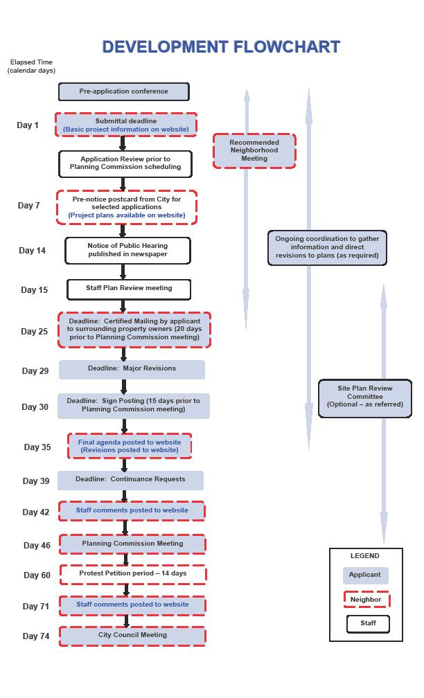
25 application by the Planning Commission. Public Notification Process In the case of a rezoning, special use permit, preliminary plat, preliminary plan and in some cases a revised preliminary development plan, surrounding property owners will be notified of the pending application. In accordance with state law, all property owners within 200 feet of the property (or if the application is located adjacent to unincorporated properties, owners of unincorporated property within 1,000 feet) will receive a certified letter with information about the application, the public hearing date, and their right to file a protest petition. Certified letters must be mailed at least 20 days prior to the scheduled hearing. For significant development proposals or proposals which appear to be controversial, the city will send an early postcard notice informing surrounding property owners, and registered homes associations and neighborhood organizations of the pending application. For rezonings and special use permits, a notice of the upcoming hearing is placed in the Overland Park Sun newspaper a minimum of 20 days prior to the hearing. Additionally, for these applications and for residential day care requests, a sign will be posted on the property 15 days in advance of the hearing indicating the nature of the request and the day and time of the hearing. If an item is continued, the sign will be updated with the new hearing date. Staff Review Process Staff review of a development proposal begins with a pre-application conference. At that time, representatives from Planning and Development Services Department will discuss with an applicant the process for seeking approval for their project, the requirements for submittal including any technical studies, specific development requirements and the Comprehensive Plan recommendations for the property. Once an applicant has prepared plans, the staff will begin reviewing them for conformance with the requirements of the Unified Development Ordinance, applicable Design Guidelines and Standards, the Comprehensive Plan and for technical details such as building layout and design, traffic circulation and drainage issues. Once an application has been submitted and scheduled for Planning Commission consideration, a formal staff review is conducted by the Plan Review Committee. This Committee is made up of city staff representing the Current Planning, Building Safety, Engineering Services, Community Planning and Services Divisions of the Planning and Development Services Department and the Fire Department. Coordination through this group is also provided to the Public Works, Parks and Recreation and Police Departments. Throughout the review process, revisions may be made to the proposed plans at the initiation of the applicant or on the recommendation of staff. Major revisions must be submitted seventeen days prior to the scheduled Planning Commission meeting for an application to stay on schedule. Minor revisions may be accepted later at the discretion of the case planner. 19
1. APPLICANT: Polsinelli, Shalton & Welte is the applicant for this request.
 5. REVISED PRELIMINARY PLAN APPROVAL - THE RETREAT AT MAPLECREST - Vicinity of the northeast corner of 159 th Street and U.S. 69 Highway 1. APPLICANT: Polsinelli, Shalton & Welte is the applicant for this
LAND USE AND ZONING OVERVIEW
 OVERVIEW OF PLANNING POLICIES LAND USE AND ZONING OVERVIEW The Minneapolis Plan for Sustainable Growth and Other Adopted Plans Community Planning and Economic Development Development Services Division
PLANNED UNIT DEVELOPMENTS (Ordinance No.: 3036, 12/3/07; Repealed & Replaced by Ordinance No.: 4166, 10/15/12)
") 159.62 PLANNED UNIT DEVELOPMENTS (Ordinance No.: 3036, 12/3/07; Repealed & Replaced by Ordinance No.: 4166, 10/15/12) A. PURPOSE 1. General. The Planned Unit Development (PUD) approach provides the flexibility
159.62 PLANNED UNIT DEVELOPMENTS (Ordinance No.: 3036, 12/3/07; Repealed & Replaced by Ordinance No.: 4166, 10/15/12) A. PURPOSE 1. General. The Planned Unit Development (PUD) approach provides the flexibility
9. REZONING NO Vicinity of the northwest corner of 143 rd Street and Metcalf Avenue
 9. REZONING NO. 2002-15 Vicinity of the northwest corner of 143 rd Street and Metcalf Avenue 1. APPLICANT: Andrew Schlagel is the applicant for this request. 2. REQUESTED ACTION: The applicant is requesting
AN ORDINANCE TO AMEND SECTION OF THE RAPID CITY MUNICIPAL CODE TO ALLOW FOR ADMINISTRATIVE DISSOLUTION OF PLANNED DEVELOPMENTS
 Ordinance No. 6231 AN ORDINANCE TO AMEND SECTION 17.50.050 OF THE RAPID CITY MUNICIPAL CODE TO ALLOW FOR ADMINISTRATIVE DISSOLUTION OF PLANNED DEVELOPMENTS WHEREAS, the City of Rapid City has adopted a
Box Elder County Land Use Management & Development Code Article 3: Zoning Districts
 Chapter 3-8-1 Master Planned Community Zone Ordinance No. 316 as adopted August 11, 2009 Sections. 3-8-1 Purpose and Intent MPC Zones Created Eligibility Master Planned Community Application Submittal
The following regulations shall apply in the R-E District:
 "R-E" RESIDENTIAL ESTATE DISTRICT (8/06) The following regulations shall apply in the R-E District: 1. Uses Permitted: The following uses are permitted. A Zoning Certificate may be required as provided
Appendix J - Planned Unit Development (PUD)
") Appendix J - Planned Unit Development (PUD) Intent and Purpose The purpose of the PUD is: 1. To provide development that is consistent with the Comprehensive Land Use Plan and promote the goals and objectives
Appendix J - Planned Unit Development (PUD) Intent and Purpose The purpose of the PUD is: 1. To provide development that is consistent with the Comprehensive Land Use Plan and promote the goals and objectives
MIDWAY CITY Municipal Code
 MIDWAY CITY Municipal Code TITLE 9 ANNEXATION CHAPTER 9.01 PURPOSE CHAPTER 9.02 GENERAL REQUIREMENTS CHAPTER 9.03 PROPERTY OWNER INITIATION OF ANNEXATION CHAPTER 9.04 PROCEDURES FOR CONSIDERATION OF PETITION
Midwest City, Oklahoma Zoning Ordinance
 2010 Midwest City, Oklahoma Zoning Ordinance 9/2/2010 Table of Contents Section 1. General Provisions... 5 1.1. Citation... 5 1.2. Authority... 5 1.3. Purpose... 5 1.4. Nature and Application... 5 1.5.
ARTICLE VII. NONCONFORMITIES. Section 700. Purpose.
 ARTICLE VII. NONCONFORMITIES. Section 700. Purpose. The purpose of this chapter is to regulate and limit the development and continued existence of legal uses, structures, lots, and signs established either
Mount Airy Planning Commission March 26, Staff Report
 Mount Airy Planning Commission March 26, 2018 Staff Report Special Exception Request Mixed Use Development in CC District Recommendation to Board of Appeals CASE MA-A-18-01 Applicant: Location: Zoning:
DENTON Developer's Handbook
 DENTON Developer's Handbook A guide for land development in the City of Denton Department of Development Services 2017 2 Table of Contents 1. City of Denton Development Process...5 Role of the Development
SPECIAL ZONING DISTRICTS
 SPECIAL ZONING DISTRICTS 5.01 5.99 RESERVED 5.100 PLANNED DEVELOPMENTS: Purpose: This district is intended to accommodate unified design of residential, commercial, office, professional services, retail
PLANNED UNIT DEVELOPMENT (PUD)
") SECTION 38.01. ARTICLE 38 PLANNED UNIT DEVELOPMENT (PUD) Purpose The purpose of this Article is to implement the provisions of the Michigan Zoning Enabling Act, Public Act 110 of 2006, as amended, authorizing
SECTION 38.01. ARTICLE 38 PLANNED UNIT DEVELOPMENT (PUD) Purpose The purpose of this Article is to implement the provisions of the Michigan Zoning Enabling Act, Public Act 110 of 2006, as amended, authorizing
PLANNED UNIT DEVELOPMENT & SUBDIVISION STAFF REPORT Date: April 18, 2019
 PLANNED UNIT DEVELOPMENT & SUBDIVISION STAFF REPORT Date: April 18, 2019 DEVELOPMENT NAME SUBDIVISION NAME Springhill Village Subdivision Springhill Village Subdivision LOCATION 4350, 4354, 4356, 4358,
ARTICLE 3: Zone Districts
 ARTICLE 3: Zone Districts... 3-1 17.3.1: General...3-1 17.3.1.1: Purpose and Intent... 3-1 17.3.2: Districts and Maps...3-1 17.3.2.1: Applicability... 3-1 17.3.2.2: Creation of Districts... 3-1 17.3.2.3:
ARTICLE 14 PLANNED UNIT DEVELOPMENT (PUD) DISTRICT
 DISTRICT") ARTICLE 14 PLANNED UNIT DEVELOPMENT (PUD) DISTRICT Section 14.01 Intent. It is the intent of this Article to allow the use of the planned unit development (PUD) process, as authorized by the Michigan Zoning
ARTICLE 14 PLANNED UNIT DEVELOPMENT (PUD) DISTRICT Section 14.01 Intent. It is the intent of this Article to allow the use of the planned unit development (PUD) process, as authorized by the Michigan Zoning
In order to permit maximum applicability of the PUD District, PUD-1 and PUD-2 Districts are hereby created.
 ARTICLE III. PUD ned Unit Development Overlay District 205-128. Purpose. The PUD ned Unit Development Overlay District is intended to provide flexibility in the design of planned projects; to encourage
ARTICLE 15 - PLANNED UNIT DEVELOPMENT
 Section 15.1 - Intent. ARTICLE 15 - PLANNED UNIT DEVELOPMENT A PUD, or Planned Unit Development, is not a District per se, but rather a set of standards that may be applied to a development type. The Planned
Town of Bristol Rhode Island
 Town of Bristol Rhode Island Subdivision & Development Review Regulations Adopted by the Planning Board September 27, 1995 (March 2017) Formatted: Highlight Formatted: Font: 12 pt Table of Contents TABLE
Chapter SPECIAL USE ZONING DISTRICTS
 Chapter 20.20 Sections: 20.20.010 Urban Transition (U-T) Zoning District 20.20.020 Planned Development (P-D) Zoning Districts 20.20.010 Urban Transition (U-T) Zoning District A. Purpose. The purpose of
PLANNED UNIT DEVELOPMENT (PUD) AREA PLAN/REZONING REVIEW PROCEDURE
 AREA PLAN/REZONING REVIEW PROCEDURE") PLANNED UNIT DEVELOPMENT (PUD) AREA PLAN/REZONING REVIEW PROCEDURE Professional inquiries will be made to our Township Planning Consultant, Township Engineer, and Township Attorney to get their opinions
PLANNED UNIT DEVELOPMENT (PUD) AREA PLAN/REZONING REVIEW PROCEDURE Professional inquiries will be made to our Township Planning Consultant, Township Engineer, and Township Attorney to get their opinions
Cover Letter with Narrative Statement
 Cover Letter with Narrative Statement March 31, 2017 rev July 27, 2017 RE: Rushton Pointe Residential Planned Unit Development Application for Public Hearing for RPUD Rezone PL2015 000 0306 Mr. Eric Johnson,
PLANNING AND ZONING DEPARTMENT
 Town of Minturn Development Review Process: Guide To Planned Unit Developments (Concept Plan) This guide describes the Planned Unit Development Process. This guide should be utilized in conjunction with
UPPER MOUNT BETHEL TOWNSHIP NORTHAMPTON COUNTY, PENNSYLVANIA
 UPPER MOUNT BETHEL TOWNSHIP NORTHAMPTON COUNTY, PENNSYLVANIA JOINDER DEED / LOT CONSOLIDATION TOWNSHIP REVIEW PROCESS When accepting proposed Joinder Deeds / Lot Consolidations, review the Joinder Deed
Town of Cary, North Carolina Rezoning Staff Report 14-REZ-31 Cary Park PDD Amendment (Waterford II) Town Council Meeting January 15, 2015
 Town Council Meeting January 15, 2015") Town of Cary, North Carolina Rezoning Staff Report 14-REZ-31 Cary Park PDD Amendment (Waterford II) Town Council Meeting January 15, 2015 REQUEST To amend the Town of Cary Official Zoning Map by amending
Town of Cary, North Carolina Rezoning Staff Report 14-REZ-31 Cary Park PDD Amendment (Waterford II) Town Council Meeting January 15, 2015 REQUEST To amend the Town of Cary Official Zoning Map by amending
FREQUENTLY USED PLANNING & ZONING TERMS
 City Of Mustang FREQUENTLY USED PLANNING & ZONING TERMS Abut: Having property lines, street lines, or zoning district lines in common. Accessory Structure: A structure of secondary importance or function
A Guide to the Municipal Planning Process in Saskatchewan
 A Guide to the Municipal Planning Process in Saskatchewan A look at the municipal development permit and the subdivision approval process in Saskatchewan May 2008 Prepared By: Community Planning Branch
TOTTENHAM SECONDARY PLAN
 TOTTENHAM SECONDARY PLAN AMENDMENT NO. 11 TO THE OFFICIAL PLAN OF THE TOWN OF NEW TECUMSETH The following text and schedules to the Official Plan of the Town of New Tecumseth constitute Amendment No. 11
Special Use Permit Application & Process See Unified Development Code
 Special Use Permit Application & Process See Unified Development Code 18.40.100 Public Works Planning Division PO Box 768 100 E. Santa Fe Street Olathe, Kansas 66051 P: 913-971- 8750 F: 913-971-8960 www.olatheks.org
SECTION 16. "PUD" PLANNED UNIT DEVELOPMENT OVERLAY DISTRICT
 SECTION 6. "PUD" PLANNED UNIT DEVELOPMENT OVERLAY DISTRICT Subsection. Purpose. This district is established to achieve the coordinated integration of land parcels and large commercial and retail establishments
Section 4 Master Plan Framework
 Section 4 Master Plan Framework 4.1 PURPOSE The Master Plan, as an implementation tool of the SPC District, establishes the primary framework for the overall development of the Property. Detailed site
Chapter 22 PLANNED UNIT DEVELOPMENT.
 Chapter 22 PLANNED UNIT DEVELOPMENT. Sec. 22.1 INTENT. The use of land and the construction and use of buildings and other structures as Planned Unit Developments in Georgetown Township may be established
Draft Model Access Management Overlay Ordinance
 Draft Model Access Management Overlay Ordinance This model was developed using the City of Hutchinson and the Trunk Highway 7 corridor. The basic provisions of this model may be adopted by any jurisdiction
HOW TO APPLY FOR A USE PERMIT
 HOW TO APPLY FOR A USE PERMIT MENDOCINO COUNTY PLANNING AND BUILDING SERVICES What is the purpose of a use permit? Throughout the County, people use their properties in many different ways. They build
DRAFT FOR PUBLIC HEARING (rev. March, 2016)
") Chapter 200. ZONING Article VI. Conservation/Cluster Subdivisions 200-45. Intent and Purpose These provisions are intended to: A. Guide the future growth and development of the community consistent with
Chapter 200. ZONING Article VI. Conservation/Cluster Subdivisions 200-45. Intent and Purpose These provisions are intended to: A. Guide the future growth and development of the community consistent with
Attachment 4. Planning Commission Staff Report. June 26, 2017
 Planning Commission Staff Report June 26, 2017 Agenda #: Regular Agenda - 2 Title: Applicant: Request: Location: Existing Zoning: Proposed Use: Staff Planner: The Brands and The Brands West Eagle Crossing
# Coventry Rezoning, Variation and Preliminary/Final PUD Project Review for Planning and Zoning Commission
 #2018-21 460 Coventry Rezoning, Variation and Preliminary/Final PUD Project Review for Planning and Zoning Commission Meeting Date: May 2, 2018 public intro meeting and May 16, 2018 public hearing Requests:
CHAPTER 14 PLANNED UNIT DEVELOPMENTS
 9-14-1 9-14-1 CHAPTER 14 PLANNED UNIT DEVELOPMENTS SECTION: 9-14-1: Purpose 9-14-2: Governing Provisions 9-14-3: Minimum Area 9-14-4: Uses Permitted 9-14-5: Common Open Space 9-14-6: Utility Requirements
Operating Standards Attachment to Development Application
 Planning & Development Services 2255 W Berry Ave. Littleton, CO 80120 Phone: 303-795-3748 Mon-Fri: 8am-5pm www.littletongov.org Operating Standards Attachment to Development Application 1 PLANNED DEVELOPMENT
TOWN OF WATERVILLE VALLEY NEW HAMPSHIRE SITE PLAN REVIEW REGULATIONS
 TOWN OF WATERVILLE VALLEY NEW HAMPSHIRE Effective date March 17, 1981 Revised March 16, 1982 Revised March 13, 1986 Revised March 10, 1987 Revised March 14, 2013 Revised March 8, 2016 TOWN OF WATERVILLE
SUBDIVISION REGULATIONS
 CHAPTER 14 SUBDIVISION REGULATIONS 14-100 Provisions 14-200 Preliminary Plat 14-300 Final Plat 14-400 Replat 14-500 Minor Subdivision 14-600 Administrative Replat 14-700 Vacation of Roadways, Public Easements,
SUBDIVISION, PLANNED UNIT DEVELOPMENT, ZONING AMENDMENT, & SIDEWALK WAIVER STAFF REPORT Date: July 19, 2018
 SUBDIVISION, PLANNED UNIT DEVELOPMENT, ZONING AMENDMENT, & SIDEWALK WAIVER STAFF REPORT Date: July 19, 2018 NAME SUBDIVISION NAME LOCATION West Mobile Properties, LLC U.S. Machine Subdivision 556, 566,
Comprehensive Plan /24/01
 IV The is a central component of the Comprehensive Plan. It is an extension of the general goals and policies of the community, as well as a reflection of previous development decisions and the physical
ARTICLE 1 GENERAL PROVISIONS
 ARTICLE 1 GENERAL PROVISIONS SECTION 100 TITLE This Ordinance shall be known and cited as the "Rice Township Subdivision and Land Development Ordinance." SECTION 101 AUTHORITY Rice Township is empowered
PLANNING COMMISSION STAFF REPORT
 PLANNING COMMISSION STAFF REPORT REZONING CASE: RZ-15-002 REPORT DATE: January 26, 2016 CASE NAME: Thursday Lunch Club Rezoning PLANNING COMMISSION DATE: February 17, 2016 ADDRESS OF REZONING PROPOSAL:
13 Sectional Map Amendment
 13 Sectional Map Amendment Introduction This chapter reviews land use and zoning policies and practices in Prince George s County and presents the proposed zoning in the sectional map amendment (SMA) to
CHAPTER 10 Planned Unit Development Zoning Districts
 CHAPTER 10 Planned Unit Development Zoning Districts Section 10.1 Intent and Purpose The Planned Unit Development (PUD) districts are intended to offer design flexibility for projects that further the
City of Jacksonville Development Guide Zoning. A publication to help people understand the Zoning process in the City Jacksonville.
 City of Jacksonville Development Guide Zoning A publication to help people understand the Zoning process in the City Jacksonville. 2016 Building Department 7/15/2016 Table of Contents Introduction... 2
5.03 Type III (Quasi-Judicial) Decisions
 Decisions") 5.03 Type III (Quasi-Judicial) Decisions 5.03 General Requirements A. The purpose of this Section is to identify what types of actions are considered Type III decisions. Type III decisions involve significant
5.03 Type III (Quasi-Judicial) Decisions 5.03 General Requirements A. The purpose of this Section is to identify what types of actions are considered Type III decisions. Type III decisions involve significant
Sec Planned unit development (PUD) zoning district requirements and procedures.
 zoning district requirements and procedures.") Sec. 10-6.696. Planned unit development (PUD) zoning district requirements and procedures. (a) Purpose and intent of district. The planned unit development (PUD) zoning district is intended to provide
Sec. 10-6.696. Planned unit development (PUD) zoning district requirements and procedures. (a) Purpose and intent of district. The planned unit development (PUD) zoning district is intended to provide
610 LAND DIVISIONS AND PROPERTY LINE ADJUSTMENTS OUTSIDE A UGB
 ARTICLE VI: LAND DIVISIONS AND PROPERTY LINE ADJUSTMENTS VI-21 610 LAND DIVISIONS AND PROPERTY LINE ADJUSTMENTS OUTSIDE A UGB 610-1 Property Line Adjustments (Property Line Relocation) A property line
Guide to Preliminary Plans
 Guide to Preliminary Plans Introduction The Douglas County is committed to providing open, transparent application processes to the public. This Guide is provided to assist anyone interested in the procedures
STAFF REPORT FOR MAJOR SUBDIVISION
 STAFF REPORT FOR MAJOR SUBDIVISION FINAL PLAT CASE NO. FA-14-001 HEARING DATE: January 6, 2016 CASE NAME: Solterra Subdivision Filing No. 16 PROCEDURE: Planning Commission ADDRESS OF MAJOR SUBDIVISION
DEVELOPMENT DEPARTMENT STAFF REPORT DRESDEN HEIGHTS PHASE II DCI
 DEVELOPMENT DEPARTMENT Meeting Date: January 10, 2019 Item #: PZ2019-393 Project Name: Applicant and Owner: Proposed Development: Requests: STAFF REPORT DRESDEN HEIGHTS PHASE II DCI Dresden Heights Phase
CHAPTER IV IMPLEMENTATION
 CHAPTER IV IMPLEMENTATION Chapter Outline IV. Implementation Page A. Public Works Projects/Public Infrastructure IV-1 1. Facilities Master Plan Overview IV-1 2. Facilities Master Plan Service Standards
ZONING ORDINANCE: OPEN SPACE COMMUNITY. Hamburg Township, MI
 ZONING ORDINANCE: OPEN SPACE COMMUNITY Hamburg Township, MI ARTICLE 14.00 OPEN SPACE COMMUNITY (Adopted 1/16/92) Section 14.1. Intent It is the intent of this Article to offer an alternative to traditional
Guide to Replats. Step 1. Step 2. Step 3. Step 4. Step 5. Step 6. Step 7. Step 8. Step 9. Step 10
 Guide to Replats Introduction Douglas County is committed to providing open, transparent application processes to the public. This Guide is provided to assist anyone interested in the procedures and expectations
PLANNING COMMISSION REPORT REGULAR AGENDA
 PP-4-4-11 Item No. 9-1 PLANNING COMMISSION REPORT REGULAR AGENDA PC Staff Report 06/22/11 ITEM NO 9: PRELIMINARY PLAT; KASOLD WATER TOWER ADDITION; SE OF TAM O SHANTER & KASOLD DR (MKM) PP-4-4-11: Consider
ARTICLE 15. RULES, REGULATIONS AND DEFINITIONS
 ARTICLE 15. RULES, REGULATIONS AND DEFINITIONS Section 1. Interpretation and Construction: The following rules and regulations regarding interpretation and construction of the Ulysses-Grant County, Kansas,
3.1. OBJECTIVES FOR RESIDENTIAL LAND USE DESIGNATIONS GENERAL OBJECTIVES FOR ALL RESIDENTIAL DESIGNATIONS
 3. RESIDENTIAL LAND USE DESIGNATIONS INTRODUCTION The Residential land use designations provide for housing and other land uses that are integral to, and supportive of, a residential environment. Housing
Article 6: Planned Unit Developments
 LUDC 2013 GARFIELD COUNTY, COLORADO Article 6: Planned Unit Developments ARTICLE 6 PLANNED UNIT DEVELOPMENTS TABLE OF CONTENTS DIVISION 1. GENERAL.... 1 6-101. GENERAL PROVISIONS.... 1 A. Purpose....
Plan nt Plan Filing and
 PARISH OF ASCENSION OFFICE OF PLANNING AND DEVELOPMENT PLANNING DEPARTMENT APPENDIX VI PLANNED UNIT DEVELOPMENT (PUD) CODE Contents: 17-601. General Purpose: Procedures... 3 17-602. General Character:...
TULSA CITY COUNCIL PRESENTATION APRIL 22, 2010
 TULSA CITY COUNCIL PRESENTATION APRIL 22, 2010 Determining what types of uses are allowed on land Zoning is method of identifying different uses of land; categorizing and locating them in an urban environment
APPLICANT NAME SUBDIVISION NAME DEVELOPMENT NAME LOCATION. CITY COUNCIL DISTRICT Council District 4 PRESENT ZONING PROPOSED ZONING
 SUBDIVISION, PLANNED UNIT DEVELOPMENT, PLANNING APPROVAL, ZONING AMENDMENT, & SIDEWALK WAIVER REQUEST STAFF REPORT Date: February 17, 2010 APPLICANT NAME SUBDIVISION NAME DEVELOPMENT NAME LOCATION David
MONTGOMERY COUNTY PLANNING DEPARTMENT THE MARYLAND-NATIONAL CAPITAL PARK AND PLANNING COMMISSION
 MONTGOMERY COUNTY PLANNING DEPARTMENT THE MARYLAND-NATIONAL CAPITAL PARK AND PLANNING COMMISSION MCPB Item No. Date: 12/4/14 Preliminary Plan No. 120140200, Northwood Knolls Description Patrick Butler,
DIVISION 9. PLANNED URBAN DEVELOPMENT CLASSIFICATION BY SPECIAL USE FOR ALL ZONING DISTRICTS Sec Statement Of Purpose: (a) Planned
 Planned") DIVISION 9. PLANNED URBAN DEVELOPMENT CLASSIFICATION BY SPECIAL USE FOR ALL ZONING DISTRICTS Sec. 12-169. Statement Of Purpose: (a) Planned developments are such substantially different character from
DIVISION 9. PLANNED URBAN DEVELOPMENT CLASSIFICATION BY SPECIAL USE FOR ALL ZONING DISTRICTS Sec. 12-169. Statement Of Purpose: (a) Planned developments are such substantially different character from
THE AREA PLAN COMMISSION OF ST. JOSEPH COUNTY, IN AGENDA
 THE AREA PLAN COMMISSION OF ST. JOSEPH COUNTY, IN AGENDA Tuesday, June 20, 2017 Fourth-Floor Council Chambers 3:30 p.m. County-City Building, South Bend, IN PUBLIC HEARINGS: 1. Rezonings: A. A combined
Zoning Most Frequently Asked Questions
 Zoning Most Frequently Asked Questions Zoning is needed to achieve the following: Orderly development consistent with utility location/capacity, street network, public services; Compatible land uses in
APPLICATION REVIEW CHECKLISTS
 APPLICATION REVIEW CHECKLISTS The following must be submitted with and are part of each application. No application is complete until all required documentation has been submitted to the Community Development
STAFF REPORT PLN September 11, 2017
 Page: 1 TO: SUBJECT: GENERAL COMMITTEE APPLICATIONS FOR OFFICIAL PLAN AMENDMENT AND ZONING BY-LAW AMENDMENT 37 JOHNSON STREET WARD: WARD 1 PREPARED BY AND KEY CONTACT: SUBMITTED BY: GENERAL MANAGER APPROVAL:
CHAPTER 21.01: GENERAL PROVISIONS
 CHAPTER 21.01: GENERAL PROVISIONS 21.01.010 TITLE AND EFFECTIVE DATE... 1-2 21.01.020 AUTHORITY... 1-2 21.01.030 PURPOSE OF THIS TITLE... 1-2 21.01.040 APPLICABILITY AND JURISDICTION... 1-3 A. General...
17.0 NONCONFORMITIES CHAPTER 17: NONCONFORMITIES Purpose and Applicability
 17.0 NONCONFORMITIES 17.1 Purpose and Applicability The purpose of this section is to regulate and limit the continued existence of uses and structures established prior to the effective date of this Ordinance
Indicates Council-recommended changes Introduced by: Mr. Tackett Date of introduction: June 14, 2016 SUBSTITUTE NO. 1 TO ORDINANCE NO.
 Indicates Council-recommended changes Introduced by: Mr. Tackett Date of introduction: June 14, 2016 SUBSTITUTE NO. 1 TO ORDINANCE NO. 16-067 TO AMEND NEW CASTLE COUNTY CODE CHAPTER 40 (ALSO KNOWN AS THE
PLANNING COMMISSION STAFF REPORT
 PLANNING COMMISSION STAFF REPORT REZONING CASE: RZ-16-001 REPORT DATE: March 8, 2016 CASE NAME: Trailbreak Partners Rezoning PLANNING COMMISSION DATE: March 16, 2016 ADDRESSES OF REZONING PROPOSAL: 5501
Kitsap County Department of Community Development
 Kitsap County Department of Community Development Staff Report and Recommendation Annual Comprehensive Plan Amendment Process for 2018 George s Corner LAMIRD Boundary Adjustment Report Date 7/16/2018 Hearing
201 General Provisions
 201 General Provisions 201.01 Title 201.09 Amendments 201.02 Purpose and Intent 201.10 Public Purpose 201.03 Authority 201.11 Variances and Appeals 201.04 Jurisdiction 201.12 Nonconformances 201.05 Enactment
Town of Cary, North Carolina Rezoning Staff Report 13-REZ-31 Weston PDD Amendment at Centregreen Park Town Council Meeting March 13, 2014
 Town of Cary, North Carolina Rezoning Staff Report 13-REZ-31 Weston PDD Amendment at Centregreen Park Town Council Meeting March 13, 2014 REQUEST This proposed amendment to the Town of Cary Official Zoning
Planned Unit Development (PUD). Sections:
. Sections:") Chapter 19.07. Planned Unit Development (PUD). Sections: 19.07.01. Purpose. 19.07.02. PUD Definition and Design Compatibility. 19.07.03. General PUD Standards. 19.07.04. Underlying Zones. 19.07.05. Permitted
Chapter 19.07. Planned Unit Development (PUD). Sections: 19.07.01. Purpose. 19.07.02. PUD Definition and Design Compatibility. 19.07.03. General PUD Standards. 19.07.04. Underlying Zones. 19.07.05. Permitted
SUBJECT PARCEL(S) Property Owner(s) TMS Number Approximate Acreage Carolina Park Development, LLC
 Property Owner(s) TMS Number Approximate Acreage Carolina Park Development, LLC") Staff Report Special Planning Commission Meeting November 19, 2014 For reference, the Zoning Code and Land Development Regulations are available online. AGENDA ITEM 5c. SKETCH PLAN APPROVAL REQUEST: Request
Staff Report Special Planning Commission Meeting November 19, 2014 For reference, the Zoning Code and Land Development Regulations are available online. AGENDA ITEM 5c. SKETCH PLAN APPROVAL REQUEST: Request
Chapter Planned Residential Development Overlay
 Chapter 19.29 Planned Residential Development Overlay Sections 010 Purpose 020 Scope 030 Definitions 030 Minimum Size 040 Allowable Uses 050 Minimum Development Standards 060 Density Bonus 070 Open Space
AN ORDINANCE AMENDING AND SUPPLEMENTING THE REVISED GENERAL ORDINANCES OF THE CITY OF BAYONNE THE, CHAPTER 33 PLANNING AND DEVELOPMENT REGULATIONS
 AN ORDINANCE AMENDING AND SUPPLEMENTING THE REVISED GENERAL ORDINANCES OF THE CITY OF BAYONNE THE, CHAPTER 33 PLANNING AND DEVELOPMENT REGULATIONS WHEREAS, pursuant to N.J.S.A. 40:48-2, the Legislature
O-I (Office-Institutional) and AG-1(Agricultural)
 and AG-1(Agricultural)") PROPERTY INFORMATION ADDRESS 3503 and 3505 Bethany Bend DISTRICT, LAND LOTS 2/1 973 and 974 OVERLAY DISTRICT State Route 9 PETITION NUMBERS EXISTING ZONING O-I (Office-Institutional) and AG-1(Agricultural)
PROPERTY INFORMATION ADDRESS 3503 and 3505 Bethany Bend DISTRICT, LAND LOTS 2/1 973 and 974 OVERLAY DISTRICT State Route 9 PETITION NUMBERS EXISTING ZONING O-I (Office-Institutional) and AG-1(Agricultural)
GUIDELINES AND CRITERIA. For Granting Tax Abatement in the North Killeen Revitalization Area. Designated by the City of Killeen, Texas
 GUIDELINES AND CRITERIA For Granting Tax Abatement in the North Killeen Revitalization Area Designated by the City of Killeen, Texas Under Tax Code, Chapter 312 I. PURPOSE The designation of a Tax Abatement
Planning Department Oconee County, Georgia
 Planning Department Oconee County, Georgia STAFF REPORT REZONE CASE #: 6985 DATE: October 31, 2016 STAFF REPORT BY: Andrew C. Stern, Planner APPLICANT NAME: Williams & Associates, Land Planners PC PROPERTY
David J. Gellner, AICP, Principal Planner; (801) ; Zoning Map Amendment
 ; Zoning Map Amendment") Staff Report PLANNING DIVISION DEPARTMENT of COMMUNITY and NEIGHBORHOODS To: From: Salt Lake City Planning Commission David J. Gellner, AICP, Principal Planner; (801) 535-6107; david.gellner@slcgov.com
Staff Report PLANNING DIVISION DEPARTMENT of COMMUNITY and NEIGHBORHOODS To: From: Salt Lake City Planning Commission David J. Gellner, AICP, Principal Planner; (801) 535-6107; david.gellner@slcgov.com
31, Township 29 South, Range 25 East, Polk County, Florida, as depicted by the Land Use Plan attached
 ORDINANCE NO. 2013-04 AN ORDINANCE AMENDING THE ZONING MAP OF THE CITY OF BARTOW, FLORIDA, REZONING APPROXIMATELY 2. 2 ACRES OF LAND OWNED BY BALA3I OF POLK COUNTY, LLC AND LOCATED IN SECTION 31, TOWNSHIP
Planned Residence District (PR) To review a plan to construct 11 single family homes on approximately 4.01 acres.
 To review a plan to construct 11 single family homes on approximately 4.01 acres.") STAFF REPORT PLANNING & ZONING COMMISSION Village Green Municipal Building, Council Chambers 47 Hall Street Wednesday, March 13, 2019 7:00 P.M. 1. FINAL DEVELOPMENT PLAN REVIEW Applicant: Romanelli and
STAFF REPORT PLANNING & ZONING COMMISSION Village Green Municipal Building, Council Chambers 47 Hall Street Wednesday, March 13, 2019 7:00 P.M. 1. FINAL DEVELOPMENT PLAN REVIEW Applicant: Romanelli and
ZONING AMENDMENT & SUBDIVISION STAFF REPORT Date: November 3, 2016
 ZONING AMENDMENT & SUBDIVISION STAFF REPORT Date: November 3, 2016 APPLICANT NAME SUBDIVISION NAME David Shumer 5955 Airport Subdivision CITY COUNCIL DISTRICT District 6 5955 Airport Boulevard, 754 Linlen
Town of Cary, North Carolina Rezoning Staff Report 12-REZ-27 Morris Branch Town Council Public Hearing January 24, 2013
 Town of Cary, North Carolina Rezoning Staff Report 12-REZ-27 Morris Branch Town Council Public Hearing January 24, 2013 REQUEST To amend the Town of Cary Official Zoning Map to rezone approximately 9.0
PROPOSED AMENDMENTS TO THE DERBY ZONING REGULATIONS AUGUST 12, 2008
 ARTICLE II Definitions and word usage 195-7. Definitions and word usage. Modify the following: HOUSING FOR THE ELDERLY OLDER PERSONS Housing in accordance with and as defined in the United States Fair
REPORT TO THE SHELBY COUNTY PLANNING COMMISSION From the Department of Development Services Planning Services. February 4, 2019
 REPORT TO THE SHELBY COUNTY PLANNING COMMISSION From the Department of Development Services Planning Services February 4, 2019 Case No. Request for Rezoning Approval From E-1 to E-2 SD This is a request
Streamlining the Entitlement Process for Transit-Oriented Development
 October 2012 Streamlining the Entitlement Process for Transit-Oriented Development Best Practices Summary Setting Ideas in Motion Introduction and Overview Entitlement Process: The legal method of obtaining
Salem Township Zoning Ordinance Page 50-1 ARTICLE 50.0: PUD PLANNED UNIT DEVELOPMENT
 Salem Township Zoning Ordinance Page 50-1 ARTICLE 50.0 PLANNED UNIT DEVELOPMENT Section 50.01 Purpose The provisions of this Article provide enabling authority and standards for the submission, review,
Affordable Housing Plan
 Affordable Housing Plan CORDOVA HILLS SPECIAL PLANNING AREA 1 Proposed Project Conwy LLC is the master developer ( Master Developer ) of that certain real property in the County of Sacramento ( County
MINOR SUBDIVISION FINAL PLAT APPLICATION Town of Apex, North Carolina
 MINOR SUBDIVISION FINAL PLAT APPLICATION Town of Apex, North Carolina This document is a public record under the North Carolina Public Records Act and may be published on the Town s website or disclosed
The following information is for use by the Lincoln County Planning Board at their meeting/public hearing on February 3, 2014.
 LINCOLN COUNTY PLANNING & INSPECTIONS DEPARTMENT 302 NORTH ACADEMY STREET, SUITE A, LINCOLNTON, NORTH CAROLINA 28092 704-736-8440 OFFICE 704-736-8434 INSPECTION REQUEST LINE 704-732-9010 FAX To: Planning
Rapid City Planning Commission
 Rapid City Planning Commission Initial Planned Development Overlay Project Report March 9, 2017 Item #15 Applicant Request(s) Case # 17PD007 Initial Planned Development Overlay to allow a residential development
BARROW COUNTY, GEORGIA
 BARROW COUNTY, GEORGIA Application For Rezoning, Special Use, and Change in Conditions BARROW COUNTY DEPARTMENT OF PLANNING AND DEVELOPMENT 30 North Broad Street Winder, Georgia 30680 770-307-3034 APPLICATION