MONTGOMERY COUNTY PLANNING DEPARTMENT THE MARYLAND-NATIONAL CAPITAL PARK AND PLANNING COMMISSION
|
|
|
- Adam Newton
- 5 years ago
- Views:
Transcription
1 MONTGOMERY COUNTY PLANNING DEPARTMENT THE MARYLAND-NATIONAL CAPITAL PARK AND PLANNING COMMISSION MCPB Item No. Date: 12/4/14 Preliminary Plan No , Northwood Knolls Description Patrick Butler, Planner Coordinator, Area 2 Division, Patrick.Butler@montgomeryplanning.org, Khalid Afzal, Planner Supervisor, Area 2 Division, Khalid.Afzal@montgomeryplanning.org, Glenn Kreger, Chief, Area 2 Division Glenn.Kreger@montgomeryplanning.org, Request for resubdivision of one lot into threelots; 503 Dennis Avenue, approximately 500 feet east of the intersection of Dennis Avenue and University Boulevard West; Zoned R-60; 33,354 square feet; Currently one single-family detached dwelling on one lot with multiple accessory structures, used as a residence and landscape company; 1996 Four Corners Master Plan; Applicant Charles Clements; Filing date: 6/5/2014. Completed: 11/21/14 Summary Staff recommends approval of the Preliminary Plan with conditions, and approval of a waiver of the resubdivision criteria for 2 of 3 proposed lots, pursuant to Section of the Subdivision Regulations, to provide relief from three (frontage, size, and shape) of the seven Resubdivision Criteria found within 50-29(b)(2) of the Subdivision Regulations. The Planning Board reviewed Pre-Preliminary Plan No for non-binding advice on May 16, 2013, and voiced their preference for this lot configuration.
2 PRELIMINARY PLAN RECOMMENDATION AND CONDITIONS Staff recommends approval of Preliminary Plan pursuant to Chapter 50 of the Montgomery County Subdivision Regulations subject to the following conditions: 1) This Preliminary Plan is limited to three lots for three one-family detached dwelling units. 2) The Applicant must replace the existing 4-foot wide sidewalks with 5-foot-wide sidewalks with a green panel and street trees along the property frontage of Dennis Avenue, extend this reconstructed sidewalk off-site to the existing cul-de-sacs to the east and west of the property line, and provide a pedestrian connection to the existing bus stops, as shown on the Preliminary Plan. 3) The Planning Board accepts the recommendations of the Montgomery County Department of Transportation ( MCDOT ) in its letter dated September 2, 2014, and hereby incorporates them as conditions of the Preliminary Plan approval. Therefore, the Applicant must comply with each of the recommendations as set forth in the letter, which may be amended by MCDOT provided that the amendments do not conflict with other conditions of the Preliminary Plan approval. 4) Prior to recordation of plat(s), the Applicant must satisfy the provisions for access and improvements as required by MCDOT. 5) The Planning Board has accepted the recommendations of the Montgomery County Department of Permitting Service ( MCDPS ) Water Resources Section in its stormwater management concept letter dated October 1, 2014, and hereby incorporates them as conditions of the Preliminary Plan approval. Therefore, the Applicant must comply with each of the recommendations as set forth in the letter, which may be amended by MCDPS Water Resources Section provided that the amendments do not conflict with other conditions of the Preliminary Plan approval. 6) The Subject Property is within the Northwood School cluster area. The Applicant must make a School Facilities Payment to MCDPS at the elementary, middle, and high school level at the single-family detached unit rates for all units for which a building permit is issued and a School Facilities Payment is applicable. The timing and amount of the payment will be in accordance with Chapter 52 of the Montgomery County Code. 7) The certified Preliminary Plan must contain the following note: Unless specifically noted on this plan drawing or in the Planning Board conditions of approval, the building footprints, building heights, on-site parking, site circulation, and sidewalks shown on the Preliminary Plan are illustrative. The final locations of buildings, structures and hardscape will be determined at the time of issuance of building permit(s). Please refer to the zoning data table for development standards such as setbacks, building restriction lines, building height, and lot coverage for each lot. Other limitations for site development may also be included in the conditions of the Planning Board s approval. 8) The Adequate Public Facility (APF) review for the Preliminary Plan will remain valid for eighty-five (85) months from the date of mailing of the Planning Board resolution. 9) The record plat must reflect common ingress/egress and utility easements over all shared driveways. 10) The record plat must show necessary easements. 2
, and within the boundary of the 1996 Four Corners")
3 SITE DESCRIPTION The Subject Property ( Property ) is Lot 15, of the Northwood Knolls Subdivision, Plat No. 2986, recorded in December The Property is located on the north side of Dennis Avenue, approximately 500 feet east of its intersection with University Boulevard West (MD 193), and within the boundary of the 1996 Four Corners Master Plan ( Master Plan ). It is approximately 33,354 square feet in size and is zoned R-60. Currently, the Property is improved with a one-family home and multiple accessory structures on-site, which are used to support the Clements Landscaping Company. Currently, access to the Property is from Dennis Avenue, via the adjacent Lot 17, which is owned by the Applicant. The surrounding land uses are one-family detached houses on lots ranging from 5,500 to 12,100 square feet, in the R-60 Zone. Image 1 Vicinity The Property, located in the Northwest Branch Watershed, contains several trees along the Dennis Avenue frontage, and contains no known streams or wetlands. It is approximately 10-feet higher in grade than Dennis Avenue, and slightly higher than the adjacent lots to the east and west. Otherwise, the Property is relatively flat and well landscaped. 3

4 Image 2 Site Aerial PROPOSAL Under the R-60 Zone, the Property could have a maximum of five lots based on its size; however, the Applicant is seeking approval of a resubdivision into three lots. The Applicant s proposal would create three lots, two of which would be flag lots with 25 feet of street frontage each, and a shared private driveway. The three lots will be served by public water and sewer, and vehicular access to each lot will be provided via a shared driveway from Dennis Avenue. No additional right-of-way is required for Dennis Avenue. Five foot-wide sidewalks will be installed between the two cul-de-sacs on the north side of Dennis Avenue, as shown on the Preliminary Plan (Attachment A). 4

5 Image 3 Preliminary Plan COMMUNITY OUTREACH The Applicant has complied with all submittal and noticing requirements, and Staff has not received correspondence from any community groups or citizens as of the date of this report. ANALYSIS AND FINDINGS Master Plan Compliance The Four Corners Master Plan supports the retention and reconfirmation of the R-60 Zone and residential land use for the Subject Property. There are no specific recommendations for the Property or surrounding area that are applicable. The Master Plan contains a general recommendation regarding vehicular and pedestrian connectivity. The proposed Preliminary Plan satisfies that recommendation by providing adequate vehicular and pedestrian access to the site, and by improving the sidewalks along Dennis Avenue. Other agencies have reviewed the proposed application and determined that the proposed use will not adversely impact environmental, land use and zoning, transportation, or community facilities as identified by the Master Plan. The proposed application will create three lots that are consistent with the zoning and residential use identified by the Master Plan. Therefore, the proposed Preliminary Plan conforms to the Four Corners Master Plan. 5
6 Public Facilities Roads and Transportation Facilities The three single-family detached units proposed do not generate 30 or more vehicle trips during the weekday morning or evening peak-hours. Therefore, the application is not required to submit a traffic study to satisfy the Local Area Transportation Review (LATR) test, and since the proposed lots will generate fewer than three peak-hour trips during the weekday or evening peak-hours, mitigation is not required to satisfy the Transportation Policy Area Review (TPAR) test. Dennis Avenue is a 60-foot wide Primary Residential Street, P-7, with Class III or PB-10, signed shared roadway bikeway as recommended in the 1996 Approved and Adopted Four Corners Master Plan. Additional dedication of right-of-way is not required. Per the County Road Code, sidewalks are required for lots in the R-60 Zone. The Applicant is required to replace the existing 4-foot wide sidewalks with 5- foot wide sidewalks with a green panel and street trees along the property frontage of Dennis Avenue. In addition, the Applicant is required to extend this reconstructed sidewalk off-site to the existing cul-desacs to the east and west of the property line and to provide a sidewalk connection to the existing bus stops, as shown on the Preliminary Plan. Other Public Facilities and Services Other public facilities and services are available and will be adequate to serve the proposed dwelling units. The application meets the Montgomery County Fire and Rescue Service requirements for fire and rescue vehicle access. Other public facilities and services, such as police stations, firehouses and health services are currently operating within the standards set by the Subdivision Staging Policy currently in effect. Electrical and telecommunications services are also available to serve the Property. The Subject Property is within the Northwood school cluster, which is subject to a School Facilities Payment at the elementary, middle, and high school levels. Therefore, a school facilities payment related to the Subdivision Staging Policy is required for the two new residential units/lots proposed. Environment Environmental Guidelines and Forest Conservation There are no environmentally sensitive features on this property. In addition, the Property is subject to the Chapter 22A Montgomery County Forest Conservation Law. However, it is exempt from the requirements of submitting a Forest Conservation Plan (FCP) per an FCP Exemption request, E, approved on April 1, 2014 (Attachment B). This exemption is based on an activity occurring on a tract of land less than 1.0 acre that will not result in the clearing of more than a total of 20,000 square feet of existing forest, or any existing specimen or champion tree, and reforestation requirements would not exceed 10,000 square feet. Per Section 22A-6(b), the Applicant submitted a tree save plan showing detailed and specific tree protection measures for on-site and off-site trees. Therefore, this plan complies with the Montgomery County Environmental Guidelines and satisfies the requirements of the Forest Conservation Law. Stormwater Management & Sediment Control The MCDPS Stormwater Management Section issued a letter accepting the stormwater management concept for the Northwood Knolls site on October 1, The stormwater management concept proposes to meet required stormwater management goals via Environmentally Sensitive Design through the use of dry wells, landscape infiltration, permeable pavement, and non-rooftop disconnect. 6

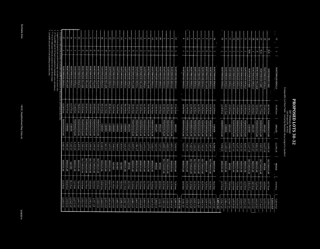
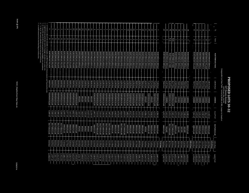
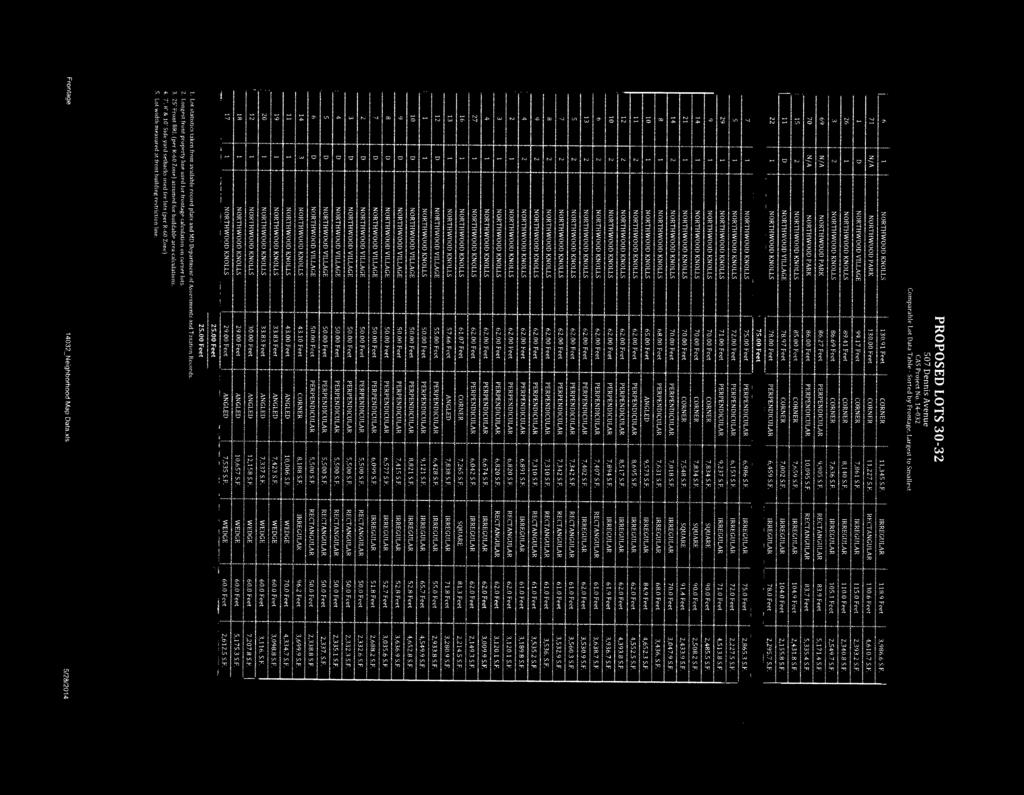
7 Compliance with the Subdivision Regulations and Zoning Ordinance This application has been reviewed for compliance with Chapter 50 of the Montgomery County Code, the Subdivision Regulations. The application meets all applicable sections, including the requirements for resubdivision, except for the frontage, size, and shape criteria, as discussed below. The proposed lots meet the dimensional requirements of the R-60 Zone. The application has been reviewed by other applicable County agencies, all of whom have recommended approval of the plan (Attachment C). Conformance with Section 50-29(b)(2) Resubdivision (Attachment D Neighborhood Map & Resubdivision Data Table) Image 4 Neighborhood A. Statutory Review Criteria In order to approve an application for resubdivision, the Planning Board must find that the proposed lot(s) comply with all seven of the resubdivision criteria, set forth in Section 50-29(b)(2) of the Subdivision Regulations, which states: Resubdivision. Lots on a plat for the Resubdivision of any lot, tract or other parcel of land that is part of an existing subdivision previously recorded in a plat book shall be of the same character as to street frontage, alignment, size, shape, width, area and suitability for residential use as other lots within the existing block, neighborhood or subdivision. B. Neighborhood Delineation In administering Section 50-29(b)(2) of the Subdivision Regulations, the Planning Board must determine the appropriate Neighborhood for evaluating the application. In this instance, the Neighborhood selected by the applicant, and agreed to by staff, consists of 53 lots, and includes all lots fronting on 7
8 Dennis Avenue from University Boulevard West to Edgewood Avenue, as well as those properties fronting Kerwin Road, Edgewood Avenue and University Boulevard West. All lots within the proposed Neighborhood share the same R-60 Zone classification as the Property. Staff finds the proposed Neighborhood provides an adequate sample of the lots and development pattern of the area. C. Analysis Comparison of the Character of Proposed Lots to Existing Lots in the Neighborhood In performing the analysis, staff applied the above-noted resubdivision criteria to the delineated Neighborhood. Proposed Lots 31 and 32 will be pipestem lots, if approved. They will establish the smallest frontage and only pipestem shaped lots in the Neighborhood. While the Property is currently the largest lot in the neighborhood, Proposed Lot 32 will continue to be the largest in size, but at 15,382 square feet in size, it will be less than half the size of the existing lot. Staff recommends a Subdivision Regulation Waiver pursuant to Section of the Subdivision Regulations to provide relief from three (frontage, size, and shape) of the seven Resubdivision Criteria found within 50-29(b)(2) of the Subdivision Regulations. Specifically, proposed Lot 31 will require a waiver of frontage and shape, while proposed Lot 32 will require a waiver of frontage, size, and shape. The proposed lots are of the same character with respect to the resubdivision criteria as other lots within the defined Neighborhood. As set forth below, the attached tabular summary and graphical documentation demonstrate that the proposal complies with Section 50-20(b)(2): Frontage: Lot frontage ranges from 29 feet to 130 feet. 20 of the existing lots have frontage of 60 feet or less, while the remaining 33 lots have frontage of 62 feet or more. The frontage for Proposed Lot 30 (75 feet) clearly falls within the acceptable range established by the Neighborhood. Therefore, Proposed Lot 30 will be of the same character as existing lots in the Neighborhood with respect to lot frontage. Proposed Lots 31 and 32 are flag lots, and each will have 25 feet of frontage. These would be the smallest in the Neighborhood, and not within the range of all other lots. Lot 17, which abuts the Property, has 29 feet of frontage. Staff recommends a waiver under 50-38(a)(1) for proposed Lots 31 and 32. Alignment: The road network in the Neighborhood is a combination of grid and cul-de-sac pattern. The majority of the lots in the Neighborhood are perpendicular to Dennis Avenue, while there are two small cul-de-sacs that create a radial alignment. Eight lots are radial, while the remaining lots are perpendicular to Dennis Avenue. The three proposed lots will be perpendicular to Dennis Avenue, which is in character with the majority of lots in the Neighborhood. The proposed lots are of the same character as existing lots with respect to the alignment criterion. Size: Lot sizes in the Neighborhood range from 5,500 square feet to 12,158 square feet. Thirty eight of the existing lots in the Neighborhood are 8,000 square feet or smaller; while the remaining 15 lots are between 8,000 square feet and 12,158 square feet. Proposed Lots 30 and 31 will be 7,895 square feet and 10,077 square feet, respectively. Therefore, the size of the Proposed Lots 30 and 31 are in character with the existing lots in the neighborhood. Proposed Lot 32 will be 15,382 square feet in size. The Property is currently 33,354 square feet in size and the largest in the Neighborhood. Once subdivided, proposed Lot 32 will be the largest 8
9 in the neighborhood, however proposed Lot 32 will be less than ½ the size of the current configuration and excess square footage is contained in the pipestem. Actual usable area of the lot is in conformance with the Neighborhood. Staff recommends a waiver under 50-38(a)(1) for proposed Lot 32. Shape: Thirty of the existing lots in the Neighborhood are rectangular, 17 are irregular, and six are triangular/wedge shaped. Proposed Lot 30 is rectangular, which is consistent with the majority of the lots in the Neighborhood. The shape of Proposed Lot 30 will be in character with shapes of the existing lots in the Neighborhood. Proposed Lots 31 and 32 will both be pipestem with respect to shape. Currently, there are no pipestem shaped lots in the Neighborhood. However, when the Property and surrounding block was originally platted, the owner arranged the lots and blocks leaving no other way to further subdivide Lot 15, unless the Planning Board would approve a pipestem configuration, or waive the requirement for lot frontage entirely. Staff recommends a waiver under 50-38(a)(1) for Proposed Lots 31 and 32. Width: Lot widths in the Neighborhood range from 50 feet to 130 feet. Forty-four of the 53 lots range in width from 50 feet to 90 feet, while the remaining 9 lots are 90 feet to 130 feet wide. Proposed Lots 30, 31, and 32 will have a lot width of 75 feet, 100 feet, and 125 feet, respectively. Therefore, the proposed lots will be in character with existing lots in the Neighborhood with respect to width. Area: The buildable area of existing lots in the Neighborhood ranges from 2,149 square feet to 7,207 square feet. Of the 53 lots, 41 range in size from 2,149 to 4,000 square feet, while the remaining 12 lots range in size from 4,000 to 7,207 square feet. Proposed Lots 30, 31, and 32 will have buildable areas of 3,435, 3,809, and 6,221 square feet, respectively. Therefore, the proposed lots will be in character with existing lots in the Neighborhood with respect to buildable area. Suitability for Residential Use: The existing and the proposed lots are zoned residential and the land is developed for residential use. The lots are therefore in character with the rest of the neighborhood. D. Subdivision Regulations Waiver 50-38(a)(1) The Planning Board has the authority to grant waiver of any requirement of Chapter 50 pursuant to Section 50-38(a)(1) of the Subdivision Regulations provided certain findings can be made. The section states: The Board may grant a waiver from the requirements of this Chapter upon a determination that practical difficulties or unusual circumstances exist that prevent full compliance with the requirements from being achieved, and that the waiver is: 1) the minimum necessary to provide relief from the requirements; 2) not inconsistent with the purposes and objectives of the General Plan; and 3) not adverse to the public interest. Staff finds that a practical difficulty exists due to the size and shape of the Property. The Property is by far the largest lot in the Neighborhood, but has only 125 feet of frontage. The Property s configuration with narrow street frontage, long depth, and the frontage and minimum width at front building restriction standards of the Zone limit the number of lots that could otherwise be approved on a 9
10 property with longer frontage along Dennis Avenue. As was previously presented and discussed with the Planning Board at the Pre-Preliminary Plan hearing, any approval of a subdivision including more than two lots on the Property will require a waiver of certain resubdivision criteria. The waiver request pertains to proposed Lots 31 and 32; Lot 30 does not require a waiver. Lot 31 will be consistent with alignment, size, width, area and suitability for residential use, but a waiver is required for street frontage and shape. Lot 32 will be consistent with alignment, width, area and suitability for residential use, but a waiver is required for street frontage, size, and shape. As outlined above, Lot 15 is much larger compared to the other lots in the existing neighborhood, but due to the existing size, shape, and location within the existing subdivision, Lot 15 will not be able to resubdivide into the proposed configuration of lots without the requested waiver. Therefore, the requested waiver is the minimum necessary to provide relief from the requirements. The Four Corners Master Plan recommends retention and reconfirmation of the R-60 Zone and residential development. The Applicant s proposed resubdivision is consistent with the recommendations of the Four Corners Master Plan. Therefore, the waiver is not inconsistent with the General Plan. The proposed lots will be of similar character to other lots within the Neighborhood, and provide adequate buildable area for appropriate orientation of new houses while providing for required setbacks and stormwater management facilities. No other reviewing agency has raised any concerns or objections to granting the waiver. Staff finds that all required findings have been made pursuant to Section 50-38(a)(1) and recommends approval of a waiver of Section 50-29(b)(2) for street frontage and shape of proposed Lot 31, and for street frontage, size, and shape of proposed Lot 32. Therefore, the waiver is not adverse to the public interest. CONCLUSION Section 50-29(b)(2) of the Subdivision Regulations specifies seven criteria with which resubdivided lots must comply. They are street frontage, alignment, size, shape, width, area and suitability for residential use within the existing block, neighborhood or subdivision. As set forth above, the proposed lots are of the same character as the existing lots in the defined neighborhood with respect to each of the resubdivision criteria except for frontage and shape of Lot 31, and frontage, size, and shape of Lot 32. A waiver of those characteristics is justified as outlined above. The proposed lots also meet all other requirements established in the Subdivision Regulations and the Zoning Ordinance, and the proposed Preliminary Plan is in substantial conformance with the recommendations of the Four Corners Master Plan. Access and public facilities will be adequate to serve the proposed lots, and the application has been reviewed by other applicable County agencies, all of whom have recommended approval of the plan. Therefore, Staff recommends approval of the application with the conditions listed at the beginning of this report. Attachments Attachment A Preliminary Plan Attachment B FCP Exemption Letter Attachment C Agency Correspondence Attachment D Neighborhood Map & Resubdivision Data Table 10
11 1 OF CIVIL SURVEYING LAND PLANNING fax office Mount Airy, Maryland West Ridgeville Blvd., Suite 101 P:\2014\ Dennis Avenue\6 drawings\14032_pp+swmc+nri_v2(2015).dwg, 9/30/2014 9:50:16 AM, DWG To PDF.pc3 1

12
13
14
15
16
17
18

19 108 West Ridgeville Blvd., Suite 101 Mount Airy, Maryland office fax CIVIL SURVEYING LAND PLANNING 1 OF 1 P:\2014\ Dennis Avenue\6 drawings\14032_nmap.dwg, 5/28/2014 3:53:52 PM, jsc, (C) 2014, CAS Engineering, a division of CAS Enterprises
20
21
22
23
MONTGOMERY COUNTY PLANNING DEPARTMENT THE MARYLAND-NATIONAL CAPITAL PARK AND PLANNING COMMISSION
 MONTGOMERY COUNTY PLANNING DEPARTMENT THE MARYLAND-NATIONAL CAPITAL PARK AND PLANNING COMMISSION MCPB Item No. 3 Date: 01-31-13 Preliminary Plan 120090300, Boyds Highlands Calvin Nelson, Jr. Planner Coordinator,
RECOMMENDATION: Approval subject to the following conditions:
 RECOMMENDATION: Approval subject to the following conditions: 1) Approval under this preliminary plan is limited to 2 lots for 2 dwelling units 2) The record plat must note that the preliminary plan is
MONTGOMERY COUNTY PLANNING DEPARTMENT THE MARYLAND-NATIONAL CAPITAL PARK AND PLANNING COMMISSION
 MONTGOMERY COUNTY PLANNING DEPARTMENT THE MARYLAND-NATIONAL CAPITAL PARK AND PLANNING COMMISSION MCPB Item No. 8 Date: 03-07-13 Sonoma, Preliminary Plan, 120130040 Melissa Williams, Senior Planner, Melissa.williams@montgomeryplanning.org,
MONTGOMERY COUNTY PLANNING DEPARTMENT THE MARYLAND-NATIONAL CAPITAL PARK AND PLANNING COMMISSION
 MONTGOMERY COUNTY PLANNING DEPARTMENT THE MARYLAND-NATIONAL CAPITAL PARK AND PLANNING COMMISSION MCPB Item No.: Date: 06-21-12 The Plantations, Preliminary Plan -120090240 Benjamin Berbert, Senior Planner,
MONTGOMERY COUNTY PLANNING DEPARTMENT THE MARYLAND-NATIONAL CAPITAL PARK AND PLANNING COMMISSION
 MONTGOMERY COUNTY PLANNING DEPARTMENT THE MARYLAND-NATIONAL CAPITAL PARK AND PLANNING COMMISSION MCPB Item No.: Date: 07-28-16 Lake Normandy Estates: Pre-Preliminary Plan No. 720160020 Ryan Sigworth AICP,
MONTGOMERY COUNTY PLANNING BOARD
 MONTGOMERY COUNTYPLANNING BOARD T H E MARYLAND-NATIONAL CAPITAL PARK A N D P L A N N I N G C O M M I S S I O N MCPB NO. 10-100 Preliminary Plan No. 120100210 Date of Hearing: July 1, 2010 MONTGOMERY COUNTY
MONTGOMERY COUNTY PLANNING DEPARTMENT THE MARYLAND-NATIONAL CAPITAL PARK AND PLANNING COMMISSION
 MONTGOMERY COUNTY PLANNING DEPARTMENT THE MARYLAND-NATIONAL CAPITAL PARK AND PLANNING COMMISSION Wheaton Woods, Preliminary Plan No. 120160060 MCPB Item No. Date: 02-25-16 Lori Shirley, Planner Coordinator,
MONTGOMERY COUNTY PLANNING DEPARTMENT THE MARYLAND-NATIONAL CAPITAL PARK AND PLANNING COMMISSION
 MONTGOMERY COUNTY PLANNING DEPARTMENT THE MARYLAND-NATIONAL CAPITAL PARK AND PLANNING COMMISSION MCPB Item No. Date: 1-17-13 Preliminary Plan 120110180 - Parmjit & Saini Estates Katherine Holt, Senior
MONTGOMERY COUNTY PLANNING DEPARTMENT THE MARYLAND-NATIONAL CAPITAL PARK AND PLANNING COMMISSION
 MONTGOMERY COUNTY PLANNING DEPARTMENT THE MARYLAND-NATIONAL CAPITAL PARK AND PLANNING COMMISSION Colesville Senior Living Facility, Limited Preliminary Plan Amendment, 12016011A MCPB Consent Item Date:
MONTGOMERY COUNTY PLANNING BOARD
 APR :7 20m MONTGOMERY COUNTY PLANNING BOARD THE MARYLAND-NATIONAL CAPITAL PARK AND PLANNING COMMISSION MCPB No. 10-172 Date of Hearing: December 9, 2010 MONTGOMERY COUNTY PLANNING BOARD RESOLUTION WHEREAS,
MONTGOMERY COUNTY PLANNING BOARD
 MONTGOMERY COUNTY PLANNING BOARD T H E MARYLAND-NATIONAL CAPITAL PARK A N D P L A N N I N G C O M M I S S I O N MCPB NO. 10-144 Hearing Date: September 30, 2010 MONTGOMERY COUNTY PLANNING BOARD RESOLUTION
MONTGOMERY COUNTY PLANNING DEPARTMENT THE MARYLAND-NATIONAL CAPITAL PARK AND PLANNING COMMISSION
 MONTGOMERY COUNTY PLANNING DEPARTMENT THE MARYLAND-NATIONAL CAPITAL PARK AND PLANNING COMMISSION MCPB Item No. Date: 05-30-13 Pre-Preliminary Plan No. 720130040: Potomac Highlands Callum Murray, supervisor,
7-l MoNtcoupnv CouNtv PreNNrNc Boeno,I 'tne ITaRYLAND-NATIoNAL CAPITAL PARI< AND PLANNING con{n{ission
 7-l MoNtcoupnv CouNtv PreNNrNc Boeno,I 'tne ITaRYLAND-NATIoNAL CAPITAL PARI< AND PLANNING con{n{ission MCPB No. 16-023 Preliminary Plan No. '120160110 Date of Hearing: March 3, 2016 ltar 17 frft, RESOLUTlON
MONTGOMERY COUNTY PLANNING DEPARTMENT THE MARYLAND-NATIONAL CAPITAL PARK AND PLANNING COMMISSION
 MONTGOMERY COUNTY PLANNING DEPARTMENT THE MARYLAND-NATIONAL CAPITAL PARK AND PLANNING COMMISSION MCPB Item No. Date: 10-11-12 Subdivision Review Waiver SRW 2011001: Big Woods Road Richard Weaver, Acting
DANAC Stiles Property. Preliminary Plan A
 DANAC Stiles Property Preliminary Plan 11996112A Vicinity Located in the LSC North District of the GSSC Master Plan. Adjacent Uses North: Single-family attached townhouses, R-60 zone; East: Office building,
Montgomery Village - South Valley Park: Subdivision Regulation Waiver SRW , and Site Plan No
 Montgomery Village - South Valley Park: Subdivision Regulation Waiver SRW - 201402, and Site Plan No. 820140070 12 SUBDIVISION REGULATION WAIVER RECOMMENDATION AND CONDITIONS OF APPROVAL Staff recommends
PGCPB No File No R E S O L U T I O N
 R E S O L U T I O N WHEREAS, Jemal s Calvert II, LLC is the owner of a 1.69-acre parcel of land known as Greenhorne & O Mara s Addition to Riverdale Gardens, Parcel 1, said property being in the 19th Election
CREEKSIDE TOWNHOMES Chevy Chase, Maryland Site Plan No Preliminary Plan No
 +1 (301) 656 5901 info@nova-habitat.com CREEKSIDE TOWNHOMES Chevy Chase, Maryland Site Plan No. 820160050 Preliminary Plan No. 120160130 Application Statement of Justification October 28, 2015 Nova-Habitat,
MONTGOMERY COUNTY PLANNING DEPARTMENT THE MARYLAND-NATIONAL CAPITAL PARK AND PLANNING COMMISSION
 MONTGOMERY COUNTY PLANNING DEPARTMENT THE MARYLAND-NATIONAL CAPITAL PARK AND PLANNING COMMISSION MCPB Item No. Date: 12/6/12 Limited Site Plan Amendment, 82000018D, DANAC Stiles Property, Lot 6 of Block
MONTGOMERY COUNTY PLANNING DEPARTMENT THE MARYLAND-NATIONAL CAPITAL PARK AND PLANNING COMMISSION
 MONTGOMERY COUNTY PLANNING DEPARTMENT THE MARYLAND-NATIONAL CAPITAL PARK AND PLANNING COMMISSION MCPB Item No.: Date: 11-12-15 15931 Frederick Road (CarMax) Annexation Request ANX2015-00145 Patrick Butler,
Community Development Department 333 Broadalbin Street SW, P.O. Box 490 Albany, OR 97321
 SUMMARY Community Development Department 333 Broadalbin Street SW, P.O. Box 490 Albany, OR 97321 STAFF REPORT Application for Tentative Partition Plat Review Planning File PA-06-17 Phone: 541-917-7550
WHEREAS, the staff of The Maryland-National Capital Park and Planning Commission recommended APPROVAL of the application with conditions; and
 R E S O L U T I O N WHEREAS, Redeemed Christian Church of God is the owner of a 2.83-acre parcel of land known as Lot 9, Lot 19, P/O Lot 1 and P/O Lot 18, Block B, Plat Book A, Plat 5, said property being
ASPEN GLEN PUD. Eighth Amended PUD Guidelines
 ASPEN GLEN PUD Eighth Amended PUD Guidelines A. Applicability Statement To carry out the purposes and provisions of the Garfield County Zoning Regulations, as amended, The Aspen Glen Club Planned Unit
ARTICLE 23 CONDOMINIUM STANDARDS
 ARTICLE 23 CONDOMINIUM STANDARDS Section 23.01 Intent. The intent of this Article is to provide regulatory standards for condominiums and site condominiums similar to those required for projects developed
MONTGOMERY COUNTY PLANNING DEPARTMENT THE MARYLAND-NATIONAL CAPITAL PARK AND PLANNING COMMISSION
 MONTGOMERY COUNTY PLANNING DEPARTMENT THE MARYLAND-NATIONAL CAPITAL PARK AND PLANNING COMMISSION MCPB Consent Item Date: 12/19/13 * Consent Item Barton Property: Preliminary Plan Amendment No. 12011021A
610 LAND DIVISIONS AND PROPERTY LINE ADJUSTMENTS OUTSIDE A UGB
 ARTICLE VI: LAND DIVISIONS AND PROPERTY LINE ADJUSTMENTS VI-21 610 LAND DIVISIONS AND PROPERTY LINE ADJUSTMENTS OUTSIDE A UGB 610-1 Property Line Adjustments (Property Line Relocation) A property line
MONTGOMERY COUNTY PLANNING DEPARTMENT THE MARYLAND-NATIONAL CAPITAL PARK AND PLANNING COMMISSION
 MONTGOMERY COUNTY PLANNING DEPARTMENT THE MARYLAND-NATIONAL CAPITAL PARK AND PLANNING COMMISSION MCPB Item No. 5 Date: 12-15-16 Bradford s Landing, Preliminary Plan, 120170060 Description Sandra Pereira,
MONTGOMERY COUNTY PLANNING DEPARTMENT THE MARYLAND-NATIONAL CAPITAL PARK AND PLANNING COMMISSION
 MONTGOMERY COUNTY PLANNING DEPARTMENT THE MARYLAND-NATIONAL CAPITAL PARK AND PLANNING COMMISSION MCPB Item No. 6 Date: 9-27-18 Seneca Farms, Preliminary Plan No. 120170240 Jonathan Casey, Senior Planner,
TULSA PARK ESTATES SUBDIVISION, RESUBDIVISION OF LOT 6
 TULSA PARK ESTATES SUBDIVISION, RESUBDIVISION OF LOT 6 Engineering Comments: FINAL PLAT COMMENTS (should be addressed prior to submitting the FINAL PLAT for review and/or signature by the City Engineer):
PLANNING COMMISSION REPORT Regular Agenda Non Public Hearing Item
 PC Staff Report 3/23/15 FDP-14-00551 Item No. 2-1 PLANNING COMMISSION REPORT Regular Agenda Non Public Hearing Item PC Staff Report 3/23/15 ITEM NO. 2: FINAL DEVELOPMENT PLAN FOR HUTTON FARMS WEST PHASE
MONTGOMERY COUNTY PLANNING DEPARTMENT THE MARYLAND-NATIONAL CAPITAL PARK AND PLANNING COMMISSION
 MONTGOMERY COUNTY PLANNING DEPARTMENT THE MARYLAND-NATIONAL CAPITAL PARK AND PLANNING COMMISSION MCPB Item No. Date: 10-1-15 Chick-fil-A Olney: Preliminary Plan No. 120150180 and Site Plan No. 820150100
M-43 CORRIDOR OVERLAY ZONE
 ARTICLE 26.00 M-43 CORRIDOR OVERLAY ZONE Section 26.01 Findings A primary function of the M-43 state highway is to move traffic through the Township and to points beyond. As the primary east-west arterial
CITY OF FERNDALE HEARING EXAMINER
 CITY OF FERNDALE HEARING EXAMINER RE: Planned Unit Development ) 16001-PUD Preliminary Plat ) 16018-SE Plat Variance ) 16002-VAR Application by ) ) MD General, L.L.C. ) FINDINGS OF FACT, Malloy Heights
MONTGOMERY COUNTY PLANNING DEPARTMENT THE MARYLAND-NATIONAL CAPITAL PARK AND PLANNING COMMISSION
 MONTGOMERY COUNTY PLANNING DEPARTMENT THE MARYLAND-NATIONAL CAPITAL PARK AND PLANNING COMMISSION MCPB Item No. 3 Date: 05/28/15 Ingleside, Preliminary Plan No. 120140140 Ryan Sigworth AICP, Senior Planner
SUBDIVISION DESIGN PRINCIPLES AND STANDARDS
 SECTION 15-200 SUBDIVISION DESIGN PRINCIPLES AND STANDARDS 15-201 STREET DESIGN PRINCIPLES 15-201.01 Streets shall generally conform to the collector and major street plan adopted by the Planning Commission
CITY OF OAK HARBOR Development Services Department
 CITY OF OAK HARBOR Development Services Department Shortt Subdiiviisiions Shorrtt Pllatt Reviiew Prrocess IIII What is a Short Plat, and when is it necessary? A short plat is a map that represents a short
Staff Report PLANNED DEVELOPMENT. Salt Lake City Planning Commission. From: Lauren Parisi, Associate Planner; Date: December 14, 2016
 Staff Report PLANNING DIVISION COMMUNITY & NEIGHBORHOODS To: Salt Lake City Planning Commission From: Lauren Parisi, Associate Planner; 801-535-7932 Date: December 14, 2016 Re: 1611 South 1600 East PLANNED
Draft Model Access Management Overlay Ordinance
 Draft Model Access Management Overlay Ordinance This model was developed using the City of Hutchinson and the Trunk Highway 7 corridor. The basic provisions of this model may be adopted by any jurisdiction
Cover Letter with Narrative Statement
 Cover Letter with Narrative Statement March 31, 2017 rev July 27, 2017 RE: Rushton Pointe Residential Planned Unit Development Application for Public Hearing for RPUD Rezone PL2015 000 0306 Mr. Eric Johnson,
MONTGOMERY COUNTY PLANNING DEPARTMENT THE MARYLAND-NATIONAL CAPITAL PARK AND PLANNING COMMISSION
 MONTGOMERY COUNTY PLANNING DEPARTMENT THE MARYLAND-NATIONAL CAPITAL PARK AND PLANNING COMMISSION MCPB Consent Item Date: 11-2-17 Washington Adventist Hospital, Site Plan Amendment No. 82008021F Rhoda Hersson-Ringskog,
DAUPHIN CREEK ESTATES SUBDIVISION
 # 12 SUB-000076-2017 DAUPHIN CREEK ESTATES SUBDIVISION Engineering Comments: FINAL PLAT COMMENTS (should be addressed prior to submitting the FINAL PLAT for review and/or signature by the City Engineer):
PLANNED UNIT DEVELOPMENT & SUBDIVISION STAFF REPORT Date: April 18, 2019
 PLANNED UNIT DEVELOPMENT & SUBDIVISION STAFF REPORT Date: April 18, 2019 DEVELOPMENT NAME SUBDIVISION NAME Springhill Village Subdivision Springhill Village Subdivision LOCATION 4350, 4354, 4356, 4358,
Organized with a "core" curriculum (the first five modules) and "electives" (the remaining modules in the program.
 and electives (the remaining modules in the program.") Introduction Sponsored by The North Carolina Chapter - American Planning Association These materials are the result of an effort by volunteer members of the North Carolina Chapter of the American Planning
Introduction Sponsored by The North Carolina Chapter - American Planning Association These materials are the result of an effort by volunteer members of the North Carolina Chapter of the American Planning
March 6, The County Board of Arlington, Virginia. Ron Carlee, County Manager
 March 6, 2003 TO: FROM: SUBJECT: The County Board of Arlington, Virginia Ron Carlee, County Manager Zoning Ordinance amendments to Section 1. Definitions, Section 31. Special Exceptions and Section 32.
MONTGOMERY COUNTY PLANNING DEPARTMENT THE MARYLAND-NATIONAL CAPITAL PARK AND PLANNING COMMISSION
 MONTGOMERY COUNTY PLANNING DEPARTMENT THE MARYLAND-NATIONAL CAPITAL PARK AND PLANNING COMMISSION MCPB Item No.: 5 Date: 09/29/2016 Washington Episcopal Day School: Preliminary Plan 120150160, Site Plan
Chapter Plat Design (LMC)
") Chapter 18.14 Plat Design (LMC) Sections: 18.14.010 Lot width 18.14.020 Right-of-way requirements 18.14.030 Pipe stem lots 18.14.040 Division resulting in minimum lot sizes 18.14.050 Flood prone and bad
Chapter 18.14 Plat Design (LMC) Sections: 18.14.010 Lot width 18.14.020 Right-of-way requirements 18.14.030 Pipe stem lots 18.14.040 Division resulting in minimum lot sizes 18.14.050 Flood prone and bad
WESTMINSTER PARK SUBDIVISION
 WESTMINSTER PARK SUBDIVISION Engineering Comments: FINAL PLAT COMMENTS (should be addressed prior to submitting the FINAL PLAT for review and/or signature by the City Engineer): A. Provide all of the required
I. Requirements for All Applications. C D W
 108-16.1. Application checklists. Checklist for Required Submissions to the Planning Board or Zoning Board of Adjustment of Monroe Township All required submissions are to be made to the Administrative
Staff Report: Date: Applicant: Property Identification: Acreage of Request: Current Zoning of Requested Area: Requested Action: Attached:
 Staff Report: Completed by Jeff Palmer Director of Planning & Zoning Date: November 7, 2018, Updated November 20, 2018 Applicant: Greg Smith, Oberer Land Developer agent for Ronald Montgomery ET AL Property
Form 11.A.9.17 INSTRUCTIONS FOR APPLICATION FOR PLAT WAIVER (Art. 11.A.8)
") Form 11.A.9.17 INSTRUCTIONS FOR APPLICATION FOR PLAT WAIVER (Art. 11.A.8) All questions in each part must be completed. When a question is not applicable to the property, enter "N/A" or other phrase indicating
Form 11.A.9.17 INSTRUCTIONS FOR APPLICATION FOR PLAT WAIVER (Art. 11.A.8) All questions in each part must be completed. When a question is not applicable to the property, enter "N/A" or other phrase indicating
Town of Cary, North Carolina Rezoning Staff Report 14-REZ-20 Habitat for Humanity Evans Road Town Council Meeting October 16, 2014
 Town of Cary, North Carolina Rezoning Staff Report 14-REZ-20 Habitat for Humanity Evans Road Town Council Meeting October 16, 2014 REQUEST To amend the Town of Cary Official Zoning Map by rezoning 0.53
PALM BEACH COUNTY PLANNING, ZONING AND BUILDING DEPARTMENT ZONING DIVISION
 PALM BEACH COUNTY PLANNING, ZONING AND BUILDING DEPARTMENT ZONING DIVISION Application No.: CA-2012-00688 Control No.: 2011-00552 Applicant: Garry Bernardo Owners: Garry Bernardo Agent: Frogner Consulting,
Chapter 100 Planned Unit Development in Corvallis Urban Fringe
 100.100 Scope and Purpose. Chapter 100 Planned Unit Development in Corvallis Urban Fringe (1) All applications for land divisions in the Urban Residential (UR) and Flood Plain Agriculture (FPA) zones within
Article Optional Method Requirements
 Article 59-6. Optional Method Requirements [DIV. 6.1. MPDU DEVELOPMENT IN RURAL RESIDENTIAL AND RESIDENTIAL ZONES Sec. 6.1.1. General Requirements... 6 2 Sec. 6.1.2. General Site and Building Type Mix...
DENTON Developer's Handbook
 DENTON Developer's Handbook A guide for land development in the City of Denton Department of Development Services 2017 2 Table of Contents 1. City of Denton Development Process...5 Role of the Development
a. provide for the continuation of collector streets and thoroughfare streets between adjacent subdivisions;
 Section 7.07. Intent The requirements of this Section are intended to provide for the orderly growth of the Town of Holly Springs and its extra-territorial jurisdiction by establishing guidelines for:
A. Location. A MRD District may be permitted throughout the County provided it meets the standards established herein.
 752. Multi-Residential District (MRD) The Multi-Residential (MRD) District is intended to provide opportunities for rural, suburban and urban density mixed-residential developments consistent with the
ARTICLE IV: DEVELOPMENT STANDARDS
 ARTICLE IV: DEVELOPMENT STANDARDS IV-53 409 PRIVATE STREETS A private street means any way that provides ingress to, or egress from, property by means of vehicles or other means, or that provides travel
DEPARTMENT OF PLANNING JEFFERSON PARISH, LOUISIANA
 DEPARTMENT OF PLANNING JEFFERSON PARISH, LOUISIANA SUBDIVISION REPORT DOCKET NO: ES-1-17-PF SUMMARY NO.: COUNCIL DISTRICT: 2 Paul D. Johnston COUNCIL AT LARGE: A: Christopher L. Roberts B: Cynthia Lee-Sheng
Preliminary Plan
 The Maryland-National Capital Park and Planning Commission Prince George's County Planning Department Development Review Division 301-952-3530 Note: Staff reports can be accessed at www.mncppc.org/pgco/planning/plan.htm.
APPLICATION FOR SUBDIVISION APPROVAL OF A SKETCH PLAN with checklist
 Prior to filing any application for SUBDIVISION approval, the applicant shall request in writing that the zoning administrator schedule a pre-submission conference. APPLICATION TO THE PLANNING BOARD TOWN
# 1 HOLDOVER Revised SUB CANAL SUBDIVISION
 CANAL SUBDIVISION Engineering Comments: Label each Lot showing the required minimum finished floor elevation (MFFE). It appears that Lots 2, 3 & 4 are located in the AE Flood Zone; add a note to the plat
MONTGOMERY COUNTY PLANNING DEPARTMENT THE MARYLAND-NATIONAL CAPITAL PARK AND PLANNING COMMISSION
 MONTGOMERY COUNTY PLANNING DEPARTMENT THE MARYLAND-NATIONAL CAPITAL PARK AND PLANNING COMMISSION MCPB Item No. xxxxx Date: 6-7-12 Hoyt Property, Preliminary/Site Plan, 120120140/820120070 Tina Schneider,
Town of Bristol Rhode Island
 Town of Bristol Rhode Island Subdivision & Development Review Regulations Adopted by the Planning Board September 27, 1995 (March 2017) Formatted: Highlight Formatted: Font: 12 pt Table of Contents TABLE
16 February 9, 2011 Public Hearing APPLICANT: GEO I, L.L.C.
 16 February 9, 2011 Public Hearing APPLICANT: GEO I, L.L.C. PROPERTY OWNER: GEO I, L.L.C., DONALD K. PILAND, AND BOOTSIE LORAINE TERRY STAFF PLANNER: Faith Christie REQUEST: Conditional Change of Zoning
Condominium Unit Requirements.
 ARTICLE 19 CONDOMINIUM REGULATIONS Section 19.01 Purpose. The purpose of this Article is to regulate projects that divide real property under a contractual arrangement known as a condominium. New and conversion
Article 7: Residential Land Use and Development Requirements
 Article 7: Residential Land Use and Section 701: Statement of Intent (A) (B) (C) The intent of Article 7 is to develop certain land use and development requirements for the residential uses within Cumru
BEAR CREEK TOWNSHIP EMMET COUNTY, MICHIGAN. PRIVATE ROAD ORDINANCE Ordinance No. 11A-99. (to replace prior Private Road Ordinance No.
 BEAR CREEK TOWNSHIP EMMET COUNTY, MICHIGAN PRIVATE ROAD ORDINANCE Ordinance No. 11A-99 (to replace prior Private Road Ordinance No. 11-99) An Ordinance to protect the health, safety, and general welfare
R E S O L U T I O N. a. Remove Table B from the plan.
 R E S O L U T I O N WHEREAS, Werrlein Property is the owner of a 0.3902-acre parcel of land in the 5th Election District of Prince George s County, Maryland, being zoned One-Family Detached Residential
ARTICLE 24 PRIVATE ROAD, SHARED PRIVATE DRIVEWAY AND ACCESS EASEMENT STANDARDS
 ARTICLE 24 PRIVATE ROAD, SHARED PRIVATE DRIVEWAY AND ACCESS EASEMENT STANDARDS SECTION 24.00 INTENT AND PURPOSE The standards of this Article provide for the design, construction and maintenance of private
MONTGOMERY COUNTY PLANNING DEPARTMENT THE MARYLAND-NATIONAL CAPITAL PARK AND PLANNING COMMISSION
 MONTGOMERY COUNTY PLANNING DEPARTMENT THE MARYLAND-NATIONAL CAPITAL PARK AND PLANNING COMMISSION MCPB Item No.: 4 Date: 2-7-19 Old Angler s Cove, Preliminary Plan No. 120170290 Ryan Sigworth AICP, Senior
-MENDOCINO COUNTY PLANNING AND BUILDING SERVICES- DIVISION OF LAND REGULATIONS TITLE 17
 ARTICLE VI -- GENERAL REGULATIONS AND PROVISIONS Sec. 17-50. Sec. 17-51 General Plan. Sec. 17-52 Lot and Block Design and Configuration. Sec. 17-53 Lot Access. Sec. 17-54 Private Roads. Sec. 17-55 Water
ARTICLE 15 - PLANNED UNIT DEVELOPMENT
 Section 15.1 - Intent. ARTICLE 15 - PLANNED UNIT DEVELOPMENT A PUD, or Planned Unit Development, is not a District per se, but rather a set of standards that may be applied to a development type. The Planned
May 12, Chapter RH HILLSIDE RESIDENTIAL ZONES REGULATIONS Sections:
 May 12, 2017 Chapter 17.13 RH HILLSIDE RESIDENTIAL ZONES REGULATIONS Sections: 17.13.010 Title, intent, and description. 17.13.020 Required design review process. 17.13.030 Permitted and conditionally
ARTICLE I ZONE BASED REGULATIONS
 ARTICLE I ZONE BASED REGULATIONS RZC 21.08 RESIDENTIAL REGULATIONS 21.08.290 Cottage Housing Developments A. Purpose. The purpose of the cottage housing requirements is to: 1. Provide a housing type that
BEFORE THE HEARING EXAMINER FOR THURSTON COUNTY
 COUNTY COMMISSIONERS Cathy Wolfe District One Diane Oberquell District Two Robert N. Macleod District Three HEARING EXAMINER BEFORE THE HEARING EXAMINER FOR THURSTON COUNTY In the Matter of the Application
ZONING AMENDMENT, PLANNED UNIT DEVELOPMENT & SUBDIVISION STAFF REPORT Date: August 8, 2013
 ZONING AMENDMENT, PLANNED UNIT DEVELOPMENT & SUBDIVISION STAFF REPORT Date: August 8, 2013 NAME SUBDIVISION NAME PV-Magnolia, LLC Twelve Trees Subdivision LOCATION 2860, 2862 and 2866 Pleasant Valley Road
MONTGOMERY COUNTY PLANNING DEPARTMENT THE MARYLAND-NATIONAL CAPITAL PARK AND PLANNING COMMISSION
 MONTGOMERY COUNTY PLANNING DEPARTMENT THE MARYLAND-NATIONAL CAPITAL PARK AND PLANNING COMMISSION MCPB Item No. 4 Date: July 24, 2017 Claiborne: Preliminary Plan No. 120170250 and Site Plan No. 820170080
VERGENNES TOWNSHIP, KENT COUNTY, MICHIGAN ORDINANCE AMENDMENT Ordinance Adopted May 17, 2004
 VERGENNES TOWNSHIP, KENT COUNTY, MICHIGAN ORDINANCE AMENDMENT Ordinance 2004-8 Adopted May 17, 2004 Private Road Ordinance Amendments An ordinance to amend portions of Section 202.000 Private Roads. The
CONDOMINIUM REGULATIONS
 ARTICLE 37 CONDOMINIUM REGULATIONS SECTION 37.01. Purpose The purpose of this Article is to regulate projects that divide real property under a contractual arrangement known as a condominium. New and conversion
AUTUMNDALE SUBDIVISION, RESUBDIVISION OF LOTS
 AUTUMNDALE SUBDIVISION, RESUBDIVISION OF LOTS 100-102 Engineering Comments: Road shall be constructed per City standards and according to the City s street acceptance process. Cul-de sac approval subject
Sterling Meadow Subdivision
 Sterling Meadow Subdivision Proposal: A pre-application conference was held on November 7, 2017, with the applicant and City staff to discuss the development. The applicant took staff s recommendations
SUBJECT PARCEL(S) Property Owner(s) TMS Number Approximate Acreage Carolina Park Development, LLC
 Property Owner(s) TMS Number Approximate Acreage Carolina Park Development, LLC") Staff Report Special Planning Commission Meeting November 19, 2014 For reference, the Zoning Code and Land Development Regulations are available online. AGENDA ITEM 5c. SKETCH PLAN APPROVAL REQUEST: Request
Staff Report Special Planning Commission Meeting November 19, 2014 For reference, the Zoning Code and Land Development Regulations are available online. AGENDA ITEM 5c. SKETCH PLAN APPROVAL REQUEST: Request
NEWTON COUNTY BOARD OF COMMISSIONERS REQUEST FOR REZONING
 NEWTON COUNTY BOARD OF COMMISSIONERS REQUEST FOR REZONING CASE NUMBER PROPOSED LAND USE MAP EXISTING LAND USE MAP PROPOSED ZONING EXISTING ZONING WATERSHED LOCATION OWNER PETITIONER REPRESENTATIVE N/A
KLUGE PLACE SUBDIVISION
 KLUGE PLACE SUBDIVISION Engineering Comments: Must comply with the Mobile County Flood Damage Prevention Ordinance. Development shall be designed to comply with the storm water detention and drainage facility
ARTICLE 15. RULES, REGULATIONS AND DEFINITIONS
 ARTICLE 15. RULES, REGULATIONS AND DEFINITIONS Section 1. Interpretation and Construction: The following rules and regulations regarding interpretation and construction of the Ulysses-Grant County, Kansas,
Town of Cary, North Carolina Site Plan Staff Report Centregreen Park at Weston (13-SP-067) Town Council Quasi-Judicial Hearing April 3, 2014
 Town Council Quasi-Judicial Hearing April 3, 2014") Town of Cary, North Carolina Site Plan Staff Report Centregreen Park at Weston (13-SP-067) Town Council Quasi-Judicial Hearing April 3, 2014 REQUEST Withers and Ravenel, on behalf of Highwoods Realty Limited
Town of Cary, North Carolina Site Plan Staff Report Centregreen Park at Weston (13-SP-067) Town Council Quasi-Judicial Hearing April 3, 2014 REQUEST Withers and Ravenel, on behalf of Highwoods Realty Limited
SECTION 16. "PUD" PLANNED UNIT DEVELOPMENT OVERLAY DISTRICT
 SECTION 6. "PUD" PLANNED UNIT DEVELOPMENT OVERLAY DISTRICT Subsection. Purpose. This district is established to achieve the coordinated integration of land parcels and large commercial and retail establishments
ARTICLE 50. PD 50. Unless otherwise stated, the definitions and interpretations in Chapter 51 apply to this
 ARTICLE 50. PD 50. SEC. 51P-50.101. LEGISLATIVE HISTORY. PD 50 was established by Ordinance No. 13428, passed by the Dallas City Council on November 8, 1971. Ordinance No. 13428 amended Ordinance No. 10962,
MONTGOMERY COUNTY PLANNING DEPARTMENT THE MARYLAND-NATIONAL CAPITAL PARK AND PLANNING COMMISSION
 MONTGOMERY COUNTY PLANNING DEPARTMENT THE MARYLAND-NATIONAL CAPITAL PARK AND PLANNING COMMISSION MCPB Item No. Hearing Date: 10/8/15 Howard Hughes Medical Institute, Limited Amendment of the Preliminary
Accessory Dwelling Unit Permit
 PLANNING SERVICES DEPARTMENT 411 Main Street (530) 87-6800 P.O. Box 3420 Chico, CA 527 Application No. APPLICATION FOR Accessory Dwelling Unit Permit Applicant Information Applicant Street Address Daytime
SECTION 10.7 R-PUD (RESIDENTIAL PLANNED UNIT DEVELOPMENT) ZONE
 ZONE") Article X Zones 10-20 SECTION 10.7 R-PUD (RESIDENTIAL PLANNED UNIT DEVELOPMENT) ZONE A. PURPOSE AND INTENT: The R-PUD Residential PUD Zone is intended to provide alternative, voluntary zoning procedures
Article X Zones 10-20 SECTION 10.7 R-PUD (RESIDENTIAL PLANNED UNIT DEVELOPMENT) ZONE A. PURPOSE AND INTENT: The R-PUD Residential PUD Zone is intended to provide alternative, voluntary zoning procedures
Open Space Model Ordinance
 Open Space Model Ordinance Section I. Background Open space development has numerous environmental and community benefits, including: 1) Reduces the impervious cover in a development. Impervious cover
DAWES SWITCHING STATION SUBDIVISION
 DAWES SWITCHING STATION SUBDIVISION Engineering Comments: Must comply with the Mobile County Flood Damage Prevention Ordinance. Development shall be designed to comply with the storm water detention and
HERON LANDING SUBDIVISION
 HERON LANDING SUBDIVISION Engineering Comments: Per FEMA guidelines, any development greater than 5 acres in size or subdivision 50 lots in size, requires a flood study. Width of drainage easement to be
ZONING AMENDMENT & SUBDIVISION STAFF REPORT Date: July 9, 2015
 ZONING AMENDMENT & SUBDIVISION STAFF REPORT Date: July 9, 2015 APPLICANT NAME 2513 Dauphin Street, Inc. SUBDIVISION NAME Audubon Place Extension No. 3, Resubdivision of Lots 1-5 LOCATION 2513 Dauphin Street
JUSTIFICATION STATEMENT FOR PRELIMINARY PLAN NO Preliminary Plan Justification for Chevy Chase Lake
 I. INTRODUCTION JUSTIFICATION STATEMENT FOR PRELIMINARY PLAN NO. 120150130 Preliminary Plan Justification for Chevy Chase Lake Applicant, CC Associates LLC (the Applicant ), by its attorneys, Linowes and
Major Subdivision Application Packet. Revised June 2018
 Major Subdivision Application Packet Revised June 2018 Caroline County Department of Planning and Community Development 233 West Broaddus Avenue Bowling Green, VA 22427 www.co.caroline.va.us Phone: 804-633-4303
PLANNED UNIT DEVELOPMENTS (Ordinance No.: 3036, 12/3/07; Repealed & Replaced by Ordinance No.: 4166, 10/15/12)
") 159.62 PLANNED UNIT DEVELOPMENTS (Ordinance No.: 3036, 12/3/07; Repealed & Replaced by Ordinance No.: 4166, 10/15/12) A. PURPOSE 1. General. The Planned Unit Development (PUD) approach provides the flexibility
159.62 PLANNED UNIT DEVELOPMENTS (Ordinance No.: 3036, 12/3/07; Repealed & Replaced by Ordinance No.: 4166, 10/15/12) A. PURPOSE 1. General. The Planned Unit Development (PUD) approach provides the flexibility
Courtyards at Kinnamon Park Sketch Plan
 Courtyards at Kinnamon Park Sketch Plan Courtyards at Kinnamon Park Sketch Plan Staff Analysis PART 1: PROJECT SUMMARY Applicant: EPCON Communities Property Owner: Johnsie M. Kinnamon Heirs, Douglas and