Referral Early Consultation
|
|
|
- Camilla Copeland
- 5 years ago
- Views:
Transcription


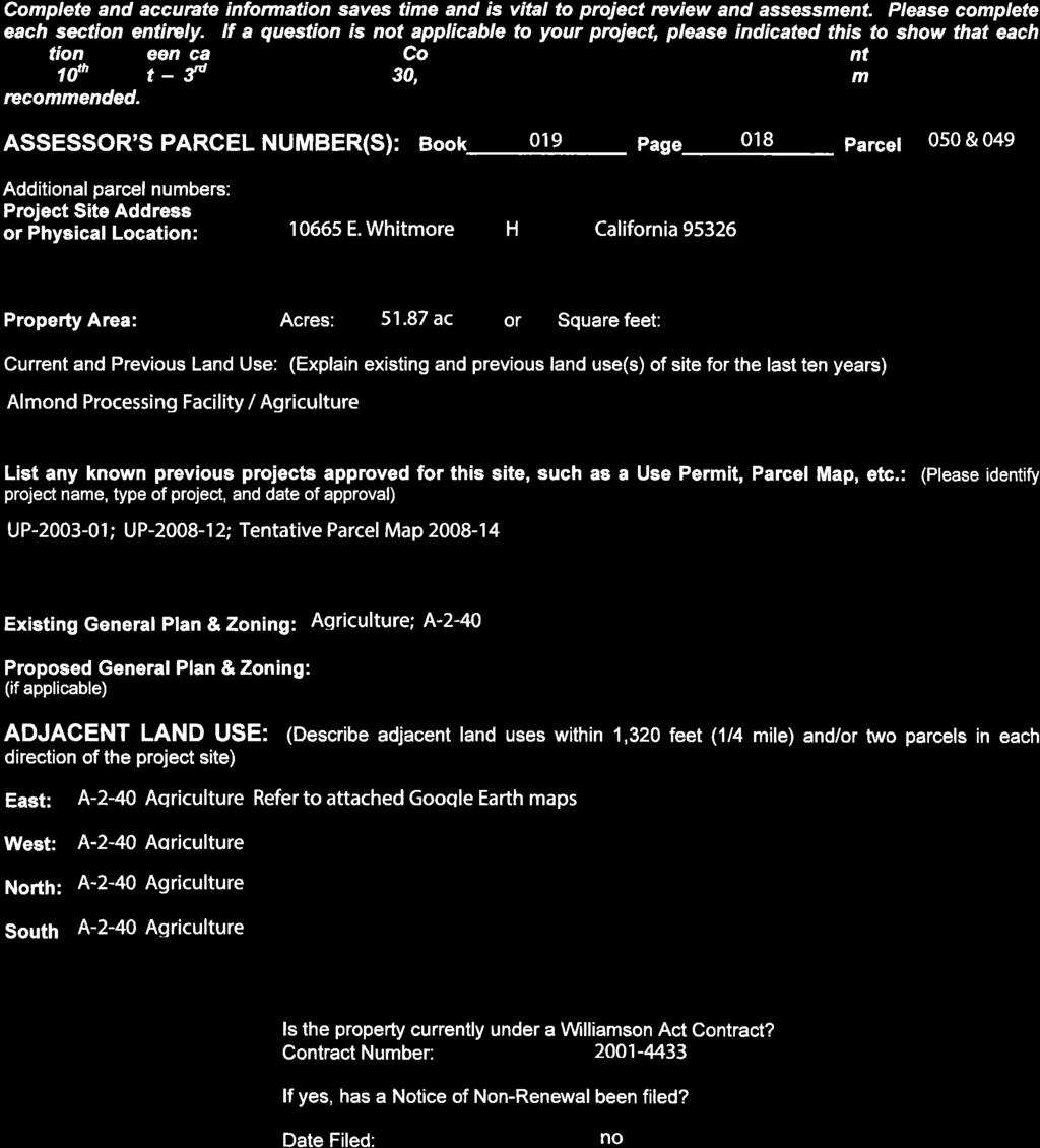
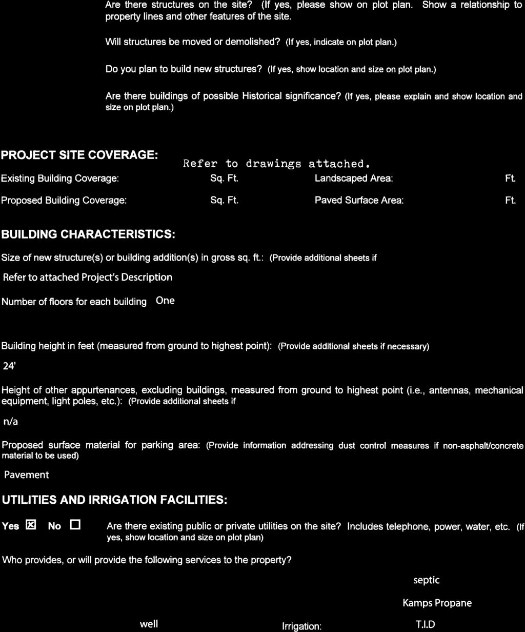
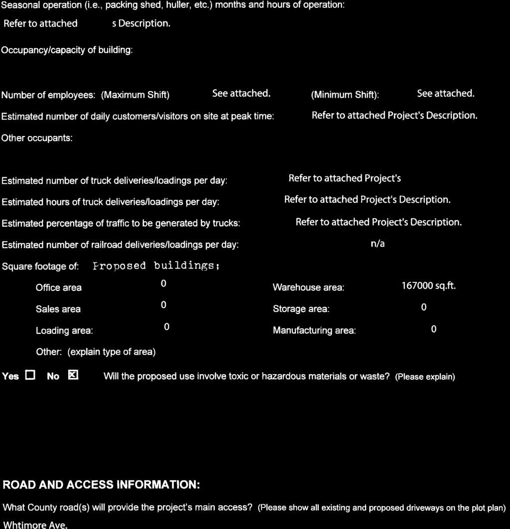
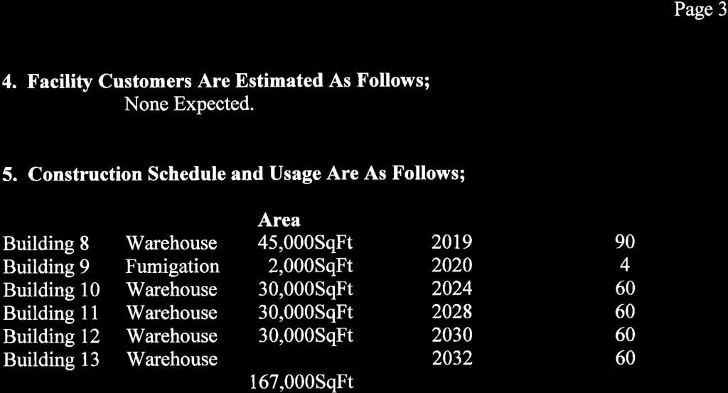
1 DEPARTMENT OF PLANNING AND COMMUNITY DEVELOPMENT th Street, Suite 3400, Modesto, CA Phone: Fax: Date: December 15, 2017 Referral Early Consultation To: Distribution List (See Attachment A) From: Subject: Kristin Doud, Senior Planned, Planning and Community Development USE PERMIT APPLICATION NO. PLN HUDELSON NUT COMPANY Respond By: January 2, 2018 ****PLEASE REVIEW REFERRAL PROCESS POLICY**** The Stanislaus County Department of Planning and Community Development is soliciting comments from responsible agencies under the Early Consultation process to determine: a) whether or not the project is subject to CEQA and b) if specific conditions should be placed upon project approval. Therefore, please contact this office by the response date if you have any comments pertaining to the proposal. Comments made identifying potential impacts should be as specific as possible and should be based on supporting data (e.g., traffic counts, expected pollutant levels, etc.). Your comments should emphasize potential impacts in areas which your agency has expertise and/or jurisdictional responsibilities. These comments will assist our Department in preparing a staff report to present to the Planning Commission. Those reports will contain our recommendations for approval or denial. They will also contain recommended conditions to be required should the project be approved. Therefore, please list any conditions that you wish to have included for presentation to the Commission as well as any other comments you may have. Please return all comments and/or conditions as soon as possible or no later than the response date referenced above. Thank you for your cooperation. Please call (209) if you have any questions. Applicant: 1998 Hudelson Family Trust, Mr. Ben Hudelson Project Location: E. Whitmore Avenue, northeast corner of Sperry Road and E. Whitmore Avenue, in the Hughson area. APN: & Williamson Act Contract: General Plan: Current Zoning: Agriculture A-2-40 (General Agriculture) Project Description: This is a request to expand an existing almond processing facility, which stores raw and packaged almonds (operating under Use Permit & ), with the construction of five additional warehouses to be utilized for almond storage and an additional fumigation building, for a total proposed additional 167,000 square feet of buildings to be constructed in phases. Building No. 8 is proposed to be 45,000 square feet in size and to be constructed by The fumigation building is proposed to be 2,000 square feet in size and to
2 be constructed by The remaining warehouses are each proposed to be 30,000 square feet in size and to be constructed one at a time between Almonds are hulled and shelled at a separate facility located on the northwest corner of Berkeley and Fox Roads. The Whitmore Avenue facility takes in already cleaned almonds from almond producers throughout the region, as well as from the operator. Cleaned almonds arrive at the site and are then sorted and packaged raw within an existing building on-site. The operation proposes to increase their truck trips from 15 per day to 25 per day during the harvest season, which typically falls between August and October/November, and from 6 truck trips per day to 10 truck trips per day during the processing season, which typically runs between October/November to June. Hours of operation are proposed to be 24 hours per day, Monday through Saturday during the harvest and processing seasons. There is no increase in the total number of employees during a maximum shift proposed, which is currently five during the harvest season, and 15 during the processing season. A lot line adjustment is also included as part of this use permit request which will adjust the project site and the surrounding almond orchard from and acres in size, to and acres in size. Full document with attachments available for viewing at: I:\Planning\Staff Reports\UP\2017\UP PLN Hudelson Nut Company\Early Consultation Referral\EARLY CONSULTATION.doc STRIVING TOGETHER TO BE THE BEST
3 USE PERMIT APPLICATION NO. PLN HUDELSON NUT COMPANY Attachment A Distribution List CA DEPT OF CONSERVATION X Land Resources STAN CO ALUC X CA DEPT OF FISH & WILDLIFE STAN CO ANIMAL SERVICES CA DEPT OF FORESTRY (CAL FIRE) X STAN CO BUILDING PERMITS DIVISION CA DEPT OF TRANSPORTATION DIST 10 X STAN CO CEO X CA OPR STATE CLEARINGHOUSE STAN CO CSA X CA RWQCB CENTRAL VALLEY REGION X STAN CO DER CA STATE LANDS COMMISSION X STAN CO ERC CEMETERY DISTRICT STAN CO FARM BUREAU CENTRAL VALLEY FLOOD PROTECTION X STAN CO HAZARDOUS MATERIALS CITY OF: STAN CO PARKS & RECREATION COMMUNITY SERVICES/SANITARY DIST X STAN CO PUBLIC WORKS X COOPERATIVE EXTENSION STAN CO RISK MANAGEMENT COUNTY OF: X STAN CO SHERIFF X FIRE PROTECTION DIST: HUGHSON FIRE X STAN CO SUPERVISOR DIST #2: CHIESA HOSPITAL DIST: X STAN COUNTY COUNSEL X IRRIGATION DIST: TURLOCK StanCOG X MOSQUITO DIST: TURLOCK X STANISLAUS FIRE PREVENTION BUREAU X MOUNTIAN VALLEY EMERGENCY MEDICAL SERVICES MUNICIPAL ADVISORY COUNCIL: X STANISLAUS LAFCO SURROUNDING LAND OWNERS (on file w/the Clerk to the Board of Supervisors) X PACIFIC GAS & ELECTRIC X TELEPHONE COMPANY: AT&T POSTMASTER: RAILROAD: TRIBAL CONTACTS (CA Government Code ) US ARMY CORPS OF ENGINEERS X SAN JOAQUIN VALLEY APCD US FISH & WILDLIFE X SCHOOL DIST 1: HUGHSON UNIFIED US MILITARY (SB 1462) (7 agencies) SCHOOL DIST 2: STAN ALLIANCE USDA NRCS WATER DIST: X STAN CO AG COMMISSIONER TUOLUMNE RIVER TRUST I:\Planning\Staff Reports\UP\2017\UP PLN Hudelson Nut Company\Early Consultation Referral\EARLY CONSULTATION.doc
4 STANISLAUS COUNTY CEQA REFERRAL RESPONSE FORM TO: Stanislaus County Planning & Community Development th Street, Suite 3400 Modesto, CA FROM: SUBJECT: USE PERMIT APPLICATION NO. PLN HUDELSON NUT COMPANY Based on this agencies particular field(s) of expertise, it is our position the above described project: Will not have a significant effect on the environment. May have a significant effect on the environment. No Comments. Listed below are specific impacts which support our determination (e.g., traffic general, carrying capacity, soil types, air quality, etc.) (attach additional sheet if necessary) Listed below are possible mitigation measures for the above-listed impacts: PLEASE BE SURE TO INCLUDE WHEN THE MITIGATION OR CONDITION NEEDS TO BE IMPLEMENTED (PRIOR TO RECORDING A MAP, PRIOR TO ISSUANCE OF A BUILDING PERMIT, ETC.): In addition, our agency has the following comments (attach additional sheets if necessary). Response prepared by: Name Title Date I:\Planning\Staff Reports\UP\2017\UP PLN Hudelson Nut Company\Early Consultation Referral\EARLY CONSULTATION.doc
5 UP PLN HUDELSON NUT COMPANY AREA MAP
6 UP PLN HUDELSON NUT COMPANY GENERAL PLAN MAP

7 UP PLN HUDELSON NUT COMPANY ZONING MAP

8 UP PLN HUDELSON NUT COMPANY 2015 AERIAL

9 UP PLN HUDELSON NUT COMPANY 2015 AERIAL
10 UP PLN HUDELSON NUT COMPANY ACREAGE MAP
11 UP PLN HUDELSON NUT COMPANY PROPOSED LOT LINE ADJUSTMENT

12 UP PLN HUDELSON NUT COMPANY SITE PLAN
13 UP PLN HUDELSON NUT COMPANY FLOOR PLAN (BLD 8)

14 UP PLN HUDELSON NUT COMPANY ELEVATIONS(BLD 8)

15
16

17
18


19
20

21

22

23
24
25 STANISLAUS COUNTY PLANNING COMMISSION February 5, 2009 STAFF REPORT USE PERMIT APPLICATION NO AND VESTING TENTATIVE PARCEL MAP APPLICATION NO BEN HUDELSON FARMS ALMOND PROCESSING FACILITY REQUEST: TO EXPAND AN EXISTING ALMOND PACKAGING FACILITY WHICH STORES AND PACKAGES RAW ALMONDS IN THREE PHASES. EACH PHASE WILL INCLUDE THE CONSTRUCTION OF A SEPARATE 15,000+ SQUARE FOOT WAREHOUSE BUILDING. APPLICATION INFORMATION Applicant/Property Owner: Ben Hudelson Family Trust Location: E. Whitmore Avenue, east of Sperry Road, in the Hughson area Section, Township, Range: Supervisorial District: District Two (Supervisor Chiesa) Assessor s Parcel: Referrals: See Exhibit F Environmental Review Referrals Area of Parcels: Parcel 1: gross acres Remainder: gross acres Water Supply: Water well Sewage Disposal: Septic/leach field system Existing Zoning: A-2-40 General Plan Designation: Agriculture Community Plan Designation: Not Applicable Williamson Act Contract No.: Environmental Review: Negative Declaration Present Land Use: Almond orchard, almond packaging facility Surrounding Land Use: Tree and row crops, pasture, and single-family dwellings, City of Hughson to the west BACKGROUND The subject facility was originally permitted for an almond processing facility under Use Permit No as a Tier Two Use Permit. Although the project has been repeatedly referred to as an Almond Processing Facility, there are no processing activities included in the operation, only the storage and packaging of raw almonds. No roasting, toasting, dicing, or flavoring of the almonds takes place within this operation. The storage and packaging of raw almonds is considered to be a Tier One use consistent with an agricultural warehouse. Accordingly, this application is being processed as a Tier One Use Permit.
26 UP , PM Staff Report February 5, 2009 Page 2 PROJECT DESCRIPTION This is a request for a warehouse expansion of an existing almond packaging facility for the storage of raw and packaged almonds in three phases. The harvest season generally runs annually between the months of September through November. The packaging schedule generally runs annually between mid-september and mid-april. The operation proposes to run 24 hours daily during the harvesting and packaging season. A maximum shift of 18 employees is anticipated at the completion of Phase III during the operating season. Each phase of expansion will include the construction of a 15,000+ square foot warehouse building. Phase I is anticipated to begin in 2011 and includes the construction of a 16,500 square foot warehouse. However, in accordance with County Ordinance Chapter Revocation of Permits, a building permit must be pulled within 18 months in order to activate the Use Permit. Phase II is anticipated to begin in 2016 and will include the construction of a 15,000 square foot warehouse. Phase III is anticipated to begin in 2018 and will include the construction of a 15,000 square foot warehouse. The operation included in this request takes in already-cleaned almonds from almond producers throughout the region, as well as from the operator s huller and sheller facility located on the northwest corner of Berkeley and Fox Roads. Cleaned almonds arrive at the site and are then sorted and packaged raw within an existing building on site. While the applicant has indicated that all equipment and supplies will be housed in the proposed buildings, temporary storage of these items outside of the building may occur from time-to-time. SITE DESCRIPTION The gross acre site is located on the northeast corner of E. Whitmore Avenue and Sperry Road, approximately 2.5 miles east of the City of Hughson. The surrounding area consists of agricultural uses, primarily orchard and row crops, and scattered single-family dwellings and farm buildings. Two one-acre home sites exist adjacent to the operation. Agricultural properties range in size from 10 to 100+ acres. Many scattered 1-3 acre home sites exist in the surrounding area. USE PERMIT DISCUSSION Almond storage facilities are classified by Chapter of the Stanislaus County Zoning Ordinance as Tier One uses. Tier One uses are uses closely related to agriculture and are considered to be necessary for a healthy agricultural economy, and may be allowed when the Planning Commission makes the following findings: 1. The establishment, maintenance, and operation of the proposed use or building applied for is consistent with the General Plan designation of General Agriculture and will not, under the circumstances of the particular case, be detrimental to the health, safety, and general welfare of persons residing or working in the neighborhood of the use and that it will not be detrimental or injurious to property and improvements in the neighborhood or to the general welfare of the County; and 2. The use as proposed will not be substantially detrimental to or in conflict with agricultural use of other property in the vicinity. In December of 2007, Stanislaus County adopted an updated Agricultural Element which
27 UP , PM Staff Report February 5, 2009 Page 3 incorporated guidelines for the implementation of agricultural buffers applicable to new and expanding non-agricultural uses within or adjacent to the A-2 zoning district. The purpose of these guidelines is to protect the long-term health of agriculture by minimizing conflicts resulting from the interaction of agricultural and non-agricultural uses. Current buffer guidelines require a project to provide a 150-foot setback, solid fencing and a double row of landscaping around the perimeter of the proposed operation. Appendix A - Buffer and Setback Guidelines of the Agricultural Element, allows the project applicant to propose an alternative buffer to be reviewed and supported by the Stanislaus County Agricultural Advisory Board. An alternative to the buffer requirements for Tier One uses was reviewed and supported by the Agricultural Advisory Board at a meeting held on Monday, September 8, This alternative waived vegetative screening provided the new use was able to provide a minimum buffer of 150 feet from all structures associated with the use to property lines. The supported alternative also waives the fencing requirement when trespassing is determined not to be a problem as is often the case with Tier One and Tier Two uses that have short seasons, few employees and take place on large agricultural parcels. In addition to the required Agricultural Advisory Board s support, the Stanislaus County Planning Commission, in accordance with Appendix A - Buffer and Setback Guidelines of the Agricultural Element, shall make a finding that the buffer alternative is found to provide equal or greater protection to surrounding agricultural uses. The proposed parcel map maintains a 150-foot buffer around the almond packaging facility on all sides and therefore matches up with the supported agricultural buffer standard. Staff believes the required Use Permit findings can be made. An agricultural buffer, supported by the Agricultural Advisory Board, has been applied to the project. The services provided by the facility are an important component of the agricultural economy in Stanislaus County and there is no indication this project will interfere or conflict with other agricultural uses in the area. PARCEL MAP DISCUSSION The site is designated Agriculture in the Land Use Element of the General Plan and is zoned A-2-40 (General Agriculture) which requires a minimum lot size of 40 acres for the creation of new parcels, which proposed Parcel 1 does not meet. However, Section of the Stanislaus County Code allows for an exemption of the minimum parcel size requirement for parcels operating under a Use Permit given that such parcel exhibits size, location, and orientation characteristics which are supportive of the use without detriment to other agricultural usage in the vicinity. If either parcel was to be placed under new ownership, each newly created parcel would be able to maintain their current operations completely independent of one another. Because no new uses are being proposed and because the use permitted on proposed Parcel 1 is closely related to agriculture, staff feels that the proposed project meets the criteria set forth in Section of the Stanislaus County Code to qualify for this exemption. WILLIAMSON ACT DISCUSSION The project site is enrolled under the Williamson Act, Contract No and has soils
28 UP , PM Staff Report February 5, 2009 Page 4 classified as Prime Farmland by the Farmland Mapping and Monitoring Program. Under the Williamson Act, lands are presumed to be too small to sustain their agricultural use if the lands are less than 40 acres in size in the case of non-prime agricultural land or 10 acres in size in the case of prime agricultural land. In this case both parcels are considered to be prime and will maintain a 10 acre or above minimum parcel size. County Code Section , in compliance with Government Code Section , specifies that uses approved on contracted lands shall be consistent with the following three principles of compatibility: 1. The use will not significantly compromise the long-term productive agricultural capability of the subject contracted parcel or parcels or on other contracted lands in the A-2 zoning district. 2. The use will not significantly displace or impair current or reasonably foreseeable agricultural operations on the subject contracted parcel or parcels or on other contracted lands in the A-2 zoning district. Uses that significantly displace agricultural operations on the subject contracted parcel or parcels may be deemed compatible if they relate directly to the production of commercial agricultural products on the subject contracted parcel or parcels or neighboring lands, including activities such as harvesting, processing, or shipping. 3. The use will not result in the significant removal of adjacent contracted land from agricultural or open-space use. Pursuant to Section , Tier One uses are considered to be consistent with the principles of compatibility and may be approved on contracted land, unless otherwise determined to be incompatible by the Planning Commission. The project was circulated to the State Department of Conservation during the initial two-week early consultation and 30-day Initial Study review and no comments were received. Based on the specific features and design of this project, it does not appear this project will impact the long-term productive agricultural capability of the subject contracted parcel or other contracted lands in the A-2 zoning district. The proposed Remainder parcel will remain in almond production and proposed Parcel 1 (with the almond packaging expansion) is related directly to the production of commercial agricultural products on the contracted parcel. There is no indication this project will result in the removal of adjacent contracted land from agricultural use. ENVIRONMENTAL REVIEW This project underwent an additional CEQA review period in order to reflect the addition of a parcel map to the project request. Pursuant to the California Environmental Quality Act (CEQA) the proposed project was circulated to various agencies, including the City of Hughson. A no comment response was received from the City of Hughson. Based on the Initial Study prepared for this project, adoption of a Negative Declaration is being proposed. The Initial Study and comments to the Initial Study have not presented any substantial information to identify a potential significant impact needing to be mitigated.
29 UP , PM Staff Report February 5, 2009 Page 5 RECOMMENDATION Based on the preceding discussion, staff recommends the Planning Commission take the following actions: 1. Adopt the Negative Declaration pursuant to CEQA Guidelines Section 15074(b), by finding that on the basis of the whole record, including the Initial Study and any comments received, that there is no substantial evidence the project will have a significant effect on the environment and that the Negative Declaration reflects Stanislaus County s independent judgement and analysis. 2. Order the filing of a Notice of Determination with the Stanislaus County Clerk-Recorders Office pursuant to Public Resources Code Section and CEQA Guidelines Section Find That: (a) (b) (c) (d) (e) (f) The establishment, maintenance, and operation of the proposed use or building applied for is consistent with the General Plan designation of Agriculture and will not, under the circumstances of the particular case, be detrimental to the health, safety, and general welfare of persons residing or working in the neighborhood of the use and that it will not be detrimental or injurious to property and improvements in the neighborhood or to the general welfare of the County. The use as proposed will not be substantially detrimental to or in conflict with agricultural use of other property in the vicinity. The alternative to the Agricultural Buffer Standards applied to this project provides equal or greater protection than the existing buffer standards. The use will not significantly compromise the long-term productive agricultural capability of the subject contracted parcel or parcels or on other contracted lands in the A-2 zoning district. The use will not significantly displace or impair current or reasonably foreseeable agricultural operations on the subject contracted parcel or parcels may be deemed compatible if they relate directly to the production of commercial agricultural product on the subject contracted parcel or parcels or neighboring lands, including activities such as harvesting, processing, or shipping. The use will not result in the significant removal of adjacent contracted land from agricultural or open-space use, and 4. Find That: (a) (b) (c) (d) (e) The proposed map is consistent with applicable general and specific plans as specified in Section The design or improvement of the proposed subdivision is consistent with applicable general and specific plans. The site is physically suitable for the type of development. The site is physically suitable for the proposed density of development. The design of the subdivision or the proposed improvements are not likely to cause substantial environmental damage or substantially and avoidably injure fish or
30 UP , PM Staff Report February 5, 2009 Page 6 (f) (g) wildlife or their habitat. The design of the subdivision or type of improvements are not likely to cause serious public health problems. The design of the subdivision or the type of improvements will not conflict with easements, acquired by the public at large, for access through or use of, property within the proposed subdivision. In this connection, the governing body may approve a map if it finds that alternate easements, for access or for use, will be provided, and that these will be substantially equivalent to ones previously acquired by the public. 5. Find the project will increase activity in and around the project area, thereby increasing demands for roads and services, thereby requiring dedications and improvements. 6. Approve Use Permit Application No and Vesting Tentative Parcel Map Application No Ben Hudelson Farms Almond Processing Facility, subject to the attached Conditions of Approval. ****** Note: Pursuant to California Fish and Game Code Section 711.4, all project applicants subject to the California Environmental Quality Act (CEQA) shall pay a filing fee for each project. Therefore, the applicant will further be required to pay $ for the Department of Fish and Game and the Clerk Recorder filing fees. The attached Conditions of Approval ensure that this will occur. Report written by: Kristin Doud, Assistant Planner, January 20, 2009 Attachments: Exhibit A - Maps Exhibit B - Project Description Exhibit C - Conditions of Approval Exhibit D - Initial Study Exhibit E - Negative Declaration Exhibit F - Environmental Review Referrals Reviewed by: Angela Freitas, Senior Planner KD:er I:\Planning\Staff Reports\UP\2008\UP PM Ben Hudelson Farms\UPwithPM\StaffReport\StaffReport.wpd
31 As Approved by the Planning Commission February 5, 2009 NOTE: Approval of this application is valid only if the following conditions are met. This permit shall expire unless activated within 18 months of the date of approval. In order to activate the permit, it must be signed by the applicant and one of the following actions must occur: (a) a valid building permit must be obtained to construct the necessary structures and appurtenances; or, (b) the property must be used for the purpose for which the permit is granted. (Stanislaus County Ordinance ) CONDITIONS OF APPROVAL USE PERMIT APPLICATION NO AND VESTING TENTATIVE PARCEL MAP APPLICATION NO BEN HUDELSON FARMS ALMOND PROCESSING FACILITY Department of Planning and Community Development 1. This use shall be conducted as described in the application and supporting information (including the plot plan) as approved by the Planning Commission and/or Board of Supervisors and in accordance with other laws and ordinances. 2. All Conditions of Approval from Use Permit shall remain in effect. 3. An agricultural buffer shall be provided between the operation and surrounding agricultural properties. The buffer shall include a minimum of 150 feet of distance from the new structures to all property lines. This buffer area shall be kept free of litter, fire hazards, pests and other maintenance problems throughout the life of the operation. 4. A Certificate of Occupancy shall be obtained from the Building Permits Division prior to occupancy, if required. (UBC Section 307) 5. All exterior lighting shall be designed (aimed down and toward the site) to provide adequate illumination without a glare effect. 6. Should any archeological or human remains be discovered during development, work shall be immediately halted within 150 feet of the find until it can be evaluated by a qualified archaeologist. If the find is determined to be historically or culturally significant, appropriate mitigation measures to protect and preserve the resource shall be formulated and implemented. 7. A plan for any proposed signs indicating the location, height, area of the sign, and message must be approved by the County Planning Department prior to installation. 8. The applicant is required to defend, indemnify, or hold harmless the County, its officers and employees from any claim, action, or proceedings against the County to set aside the approval of the project which is brought within the applicable statute of limitations. The County shall promptly notify the applicant of any claim, action, or proceeding to set aside the approval and shall cooperate fully in the defense.
32 UP , PM As Approved by the Planning Commission Conditions of Approval February 5, 2009 February 5, 2009 Page 2 9. Developer shall pay all Public Facilities Impact Fees and Fire Facilities Fees as adopted by Resolution of the Board of Supervisors. The Fees shall be payable at the time of issuance for any building permit for any construction in the development project and shall be based on the rates in effect at the time of building permit issuance. 10. Pursuant to Section of the California Fish and Game Code (effective January 1, 2009), the applicant is required to pay a Department of Fish and Game filing fee at the time of recording a Notice of Determination. Within five (5) days of approval of this project by the Planning Commission or Board of Supervisors, the applicant shall submit to the Department of Planning and Community Development a check for $ , made payable to Stanislaus County, for the payment of Fish and Game, and Clerk Recorder filing fees. Pursuant to Section (e)(3) of the California Fish and Game Code, no project shall be operative, vested, or final, nor shall local government permits for the project be valid, until the filing fees required pursuant to this section are paid. 11. Prior to construction: The developer shall be responsible for contacting the U.S. Army Corps of Engineers to determine if any wetlands, waters of the United States, or other areas under the jurisdiction of the Corps of Engineers are present on the project site, and shall be responsible for obtaining all appropriate permits or authorizations from these agencies, if necessary. Written evidence of said contact shall be submitted to the Planning Department prior to issuance of any building permit. 12. Prior to construction: The developer shall be responsible for contacting the California Department of Fish and Game and shall be responsible for obtaining all appropriate streambed alteration agreements permits or authorizations if necessary. Written evidence of said contact shall be submitted to the Planning Department prior to issuance of any building permit. 13. The Department of Planning and Community Development shall record a Notice of Administrative Conditions and Restrictions with the County Recorder s Office within 30 days of project approval. The Notice includes: Conditions of Approval/Development Standards and Schedule; any adopted Mitigation Measures; and a project area map. Building Permits Division 14. Development shall comply with current adopted Title 24 California Code of Regulations (Building Codes) and Stanislaus County Title 16 Code. Stanislaus County Fire Prevention Bureau/Hughson Fire Protection District 15. Prior to issuance of a building permit, project shall comply with current Fire Code requirements. All buildings constructed shall comply with on-site water for fire protection. An approved fire apparatus access road shall be provided. Fire Apparatus access roads shall have an unobstructed width of not less than 20 feet and an unobstructed vertical clearance of not less than 13 feet 6 inches. Dead-end fire apparatus access roads in excess of 150 feet in length shall be provided with an approved turn-around. 16. When required by the Fire Code an automatic fire sprinkler system shall be provided.
33 UP , PM As Approved by the Planning Commission Conditions of Approval February 5, 2009 February 5, 2009 Page 3 Environmental Review Committee 17. The applicant shall determine, to the satisfaction of the Department of Environmental Resources (DER), that a site containing (or formerly containing) residences or farm buildings, or structures, has been fully investigated (via Phase I study and Phase II study if necessary) prior to the issuance of a grading permit. Any discovery of underground storage tanks, former underground storage tank locations, buried chemicals, buried refuse, or contaminated soil shall be brought to the immediate attention of the DER. 18. The applicant should contact the Department of Environmental Resources regarding appropriate permitting requirements for hazardous materials and/or wastes. Applicant and/or occupants handling hazardous materials or generating hazardous wastes must notify the Department of Environmental Resources relative to the following: (Calif. H&S, Division 20) A. Permits for the underground storage of hazardous substances at a new location or the modification of existing tank facilities. B. Requirements for registering as a handler of hazardous materials in the County. C. Submittal of hazardous materials Business Plans by handlers of materials in excess of 55 gallons or 500 pounds of a hazardous material or of 200 cubic feet of compressed gas. D. The handling of acutely hazardous materials may require the preparation of a Risk Management Prevention Program that must be implemented prior to operation of the facility. The list of acutely hazardous materials can be found in SARA, Title III, Section 302. E. Generators of hazardous waste must notify the Department of Environmental Resources relative to the: (1) quantities of waste generated; (2) plans for reducing wastes generated; and (3) proposed waste disposal practices. F. Permits for the treatment of hazardous waste on-site will be required from the Hazardous Materials Division. G. Medical waste generators must complete and submit a questionnaire to the Department of Environmental Resources for determination if they are regulated under the Medical Waste Management Act. Department of Public Works 19. The recorded parcel map shall be prepared by a licensed land surveyor or a qualified registered civil engineer. 20. All existing non-public facilities and/or utilities that do not have lawful authority to occupy the road right-of-way shall be relocated onto private property upon the request of the Department of Public Works. 21. All structures not shown on the tentative parcel map shall be removed prior to the parcel map being recorded. 22. Both parcels shall be surveyed and fully monumented.
34 UP , PM As Approved by the Planning Commission Conditions of Approval February 5, 2009 February 5, 2009 Page Prior to the issuance of a building permit, the property owners shall sign a Road Easement document that will dedicate sufficient right-of-way to Stanislaus County to provide 55 feet north of the existing centerline of Whitmore Avenue along the parcel frontage containing the processing facility. 24. Prior to the on-set of any work within the County right-of-way, an encroachment permit shall be obtained through the Public Works Department. 25. The applicant shall make road frontage improvements along the entire parcel frontage on Whitmore Road. (The only parcel with the improvements shall be the parcel with the processing facility. The parcel with the orchard is not required to have the improvements installed along the frontages.) These improvements shall include a 12 foot wide paved vehicle lane and a 4 foot wide paved asphalt shoulder. Improvement plans are to be submitted to the Department of Public Works for approval. The structural section and cross slopes shall meet Stanislaus County Public Works Standards and Specifications. The plans shall be approved prior to the issuance of any building or grading permit, whichever comes first. The work shall be installed prior to occupancy of any building permit. 26. Prior to issuance of a building or grading permit and after the County Public Works Department has approved the improvement plans, an Engineer s Estimate shall be provided so the amount of the financial guarantee can be determined. This estimate will be based on the County approved street improvement plans. 27. Prior to the issuance of any building or grading permit, a Financial Guarantee in a form acceptable to the Department of Public Works shall be deposited with the department for the street improvement installation along the frontage of the parcel on Whitmore Avenue. 28. A grading and drainage plan will be submitted prior to moving any dirt on-site. This plan will be approved by the Department of Public Works prior to the issuance of a grading permit. 29. All driveways and parking areas shall be paved and double striped per county standards. 30. Any new driveway locations and widths shall be approved by the Department of Public Works. Turlock Irrigation District (TID) 31. Existing irrigation facilities shall be protected from damage during the construction phases of the proposed project. 32. Prior to recording of the parcel map, irrigation easements shall be dedicated to TID along the Bannister Branch of the Hickman pipeline, which traverses the subject parcels. Dedicated easements shall be shown on the final map. A statement of a Certificate of Acceptance, as shown on the District s October 31, 2008 project comment letter, shall appear on the final map. 33. Prior to recording of the parcel map, the final map shall be reviewed and approved by TID, to ensure Condition of Approval Number 32 has been met.
35 UP , PM As Approved by the Planning Commission Conditions of Approval February 5, 2009 February 5, 2009 Page The owner/developer must apply for a facility change for any pole or electrical facility relocation. Facility changes are performed at the developer s expense. San Joaquin Valley Air Pollution Control District (SJVAPCD) 35. In accordance with the Valley Air Pollution Control District s Rule 9510 (Indirect Source Review), the applicant shall submit an Air Impact Assessment (AIA) application to the District and pay any applicable off-site mitigation fees prior to issuance of a building permit. 36. Any construction resulting from this project shall comply with standardized dust controls adopted by the San Joaquin Valley Air Pollution Control District. 37. Prior to construction, the applicant shall contact the SJVAPCD to determine if any of the following rules are applicable: Regulation VIII (Fugitive PM10 Prohibitions) Rule 4002 (National Emission Standards for Hazardous Air Pollutants) Rule 4102 (Nuisance) Rule 4601 (Architectural Coatings) Rule 4641 (Cutback, Slow Cure, and Emulsified Asphalt, Paving, & Maintenance operations) ****** Please note: If Conditions of Approval/Development Standards are amended by the Planning Commission or Board of Supervisors, such amendments will be noted in the upper right hand corner of the Conditions of Approval/Development Standards, new wording is in bold, and deleted wording will have a line through it.
Referral Early Consultation
 DEPARTMENT OF PLANNING AND COMMUNITY DEVELOPMENT 1010 10 TH Street, Suite 3400, Modesto, CA 95354 Planning Phone: (209) 525-6330 Fax: (209) 525-5911 Building Phone: (209) 525-6557 Fax: (209) 525-7759 Date:
Referral Early Consultation
 DEPARTMENT OF PLANNING AND COMMUNITY DEVELOPMENT 1010 10 TH Street, Suite 3400, Modesto, CA 95354 Planning Phone: (209) 525-6330 Fax: (209) 525-5911 Building Phone: (209) 525-6557 Fax: (209) 525-7759 Referral
 AS AMENDED BY THE PLANNING COMMISSION MAY 19, 2005 CONDITIONS OF APPROVAL VESTING TENTATIVE PARCEL MAP APPLICATION NO. 2005-04 SUMMIT CORPORATE CENTER Department of Public Works 1. The recorded parcel
 AS AMENDED BY THE PLANNING COMMISSION MAY 5, 2005 CONDITIONS OF APPROVAL VESTING TENTATIVE PARCEL MAP APPLICATION NO. 2004-31 PATTERSON FROZEN FOODS Department of Public Works 1. The recorded parcel map
 As Amended by the Planning Commission June 16, 2005 CONDITIONS OF APPROVAL TENTATIVE PARCEL MAP APPLICATION NO. 2002-28 NANCY ABDALLAH Department of Public Works 1. The recorded parcel map shall be prepared
APPLICATION CHECKLIST
 DEPARTMENT OF PLANNING AND COMMUNITY DEVELOPMENT 1010 10TH Street, Suite 3400, Modesto, CA 95354 Phone: 209.525.6330 Fax: 209.525.5911 Form Available Online: http://www.stancounty.com/planning/applications.shtm
Trio Petroleum, Inc. (PLN010302)
") LYNNE MOUNDAY ZONING ADMINISTRATOR STATE OF CALIFORNIA COUNTY OF MONTEREY RESOLUTION NO. 010302 A.P.# 424-091-021-000 In the matter of the application of Trio Petroleum, Inc. (PLN010302) FINDINGS & DECISION
LYNNE MOUNDAY ZONING ADMINISTRATOR STATE OF CALIFORNIA COUNTY OF MONTEREY RESOLUTION NO. 010302 A.P.# 424-091-021-000 In the matter of the application of Trio Petroleum, Inc. (PLN010302) FINDINGS & DECISION
1.0 REQUEST. SANTA BARBARA COUNTY ZONING ADMINISTRATOR Coastal Zone Staff Report for Vincent New Single-Family Dwelling & Septic System
 SANTA BARBARA COUNTY ZONING ADMINISTRATOR Coastal Zone Staff Report for Vincent New Single-Family Dwelling & Septic System Hearing Date: February 26, 2007 Supervisorial District: First Staff Report Date:
MINOR SUBDIVISION COMMITTEE COUNTY OF MONTEREY, STATE OF CALIFORNIA
 MINOR SUBDIVISION COMMITTEE COUNTY OF MONTEREY, STATE OF CALIFORNIA RESOLUTION NO. 05010 In the matter the application GIANNINI FAMILY LIMITED PARTNERSHIP (PLN040273) APN# 113-071-006-000 FINDINGS & DECISION
APPLICATION PROCESSING. CHECK WITH STAFF - Development Services Staff will explain the requirements and procedures to you.
 PLANNED DEVELOPMENT ZONE 1810 E. HAZELTON AVENUE, STOCKTON CA 95205 BUSINESS PHONE: (209) 468-3121 Business Hours: 8:00 a.m. to 5:00 p.m. (Monday through Friday) STEP 1 STEP 2 FEE FORM DEED SERVICES APPLICATION
APPLICATION PROCESSING
 MAJOR SUBDIVISION 1810 E. HAZELTON AVENUE, STOCKTON CA 95205 BUSINESS PHONE: (209) 468-3121 BUSINESS HOURS: 8:00 A.M. TO 5:00 P.M..(Monday through Friday) APPLICATION PROCESSING STEPS STEP 1 STEP 2 CHECK
FORM Seven (7) copies of the completed application information forms (attached) which all owners must sign.
 copies of the completed application information forms (attached) which all owners must sign.") WILLIAMSON ACT CONTRACT CANCELLATION SAN JOAQUIN COUNTY COMMUNITY DEVELOPMENT DEPARTMENT 1810 E. HAZELTON AVENUE, STOCKTON CA 95205 BUSINESS PHONE: (209) 468-3121 Business Hours: 8:00 a.m. to 5:00 p.m.
WILLIAMSON ACT CONTRACT CANCELLATION SAN JOAQUIN COUNTY COMMUNITY DEVELOPMENT DEPARTMENT 1810 E. HAZELTON AVENUE, STOCKTON CA 95205 BUSINESS PHONE: (209) 468-3121 Business Hours: 8:00 a.m. to 5:00 p.m.
CITY OF SONORA PLANNING COMMISSION SITE PLAN REVIEW APPLICATION
 CITY OF SONORA PLANNING COMMISSION SITE PLAN REVIEW APPLICATION APPLICANT: MAILING ADDRESS: PHONE: CELL#: EMAIL: OWNER S NAME: MAILING ADDRESS: PHONE: CELL#: EMAIL: ADDRESS OF PROPERTY INVOLVED: ASSESSOR
:= Information Included
 DEPARTMENT OF PLANNING AND COMMUNITY DEVELOPMENT 1010 10th Street, Suite 3400, Modesto, CA 95354 Planning Phone: (209) 525-6330 Fax: (209) 525-5911 Building Phone: (209) 525-6557 Fax: (209) 525-7759 Form
292 West Beamer Street Woodland, CA (530) FAX (530)
 FAX (530)") - County of Yolo PLANNING AND PUBLIC WORKS DEPARTMENT John Bencomo DIRECTOR 292 West Beamer Street Woodland, CA 95695-2598 (530) 666-8775 FAX (530) 666-8728 www.yolocounty.org PLANNING COMMISSION STAFF
- County of Yolo PLANNING AND PUBLIC WORKS DEPARTMENT John Bencomo DIRECTOR 292 West Beamer Street Woodland, CA 95695-2598 (530) 666-8775 FAX (530) 666-8728 www.yolocounty.org PLANNING COMMISSION STAFF
APPLICATION PROCESSING STEPS STEP 1 CHECK WITH STAFF
 APPLICATION PROCESSING STEPS STEP 1 CHECK WITH STAFF - Development Services Staff will explain the requirements and procedures to you. However, before filing an application with the Community Development
HOW TO APPLY FOR A USE PERMIT
 HOW TO APPLY FOR A USE PERMIT MENDOCINO COUNTY PLANNING AND BUILDING SERVICES What is the purpose of a use permit? Throughout the County, people use their properties in many different ways. They build
REPORT TO PLANNING AND DESIGN COMMISSION City of Sacramento
 REPORT TO PLANNING AND DESIGN COMMISSION City of Sacramento 915 I Street, Sacramento, CA 95814-2671 www.cityofsacramento.org 9 PUBLIC HEARING December 10, 2015 To: Members of the Planning and Design Commission
PROJECT ADDRESS ASSESSOR S PARCEL NUMBER G.P. LAND USE DESIGNATION ZONING DISTRICT FLOOD HAZARD ZONE SITE ACREAGE AIRPORT SAFETY ZONE?
 TYPE OR PRINT CLEARLY Submit Completed Applications to: City of Corning Planning Dept. 794 Third Street Corning, CA 96021 PROJECT ADDRESS ASSESSOR S PARCEL NUMBER G.P. LAND USE DESIGNATION ZONING DISTRICT
FEE The staff will let you know the current cost of filing an application. Make checks payable to the San Joaquin County Treasurer.
 VARIANCE 1810 E. HAZELTON AVENUE, STOCKTON CA 95205 BUSINESS PHONE: (209) 468-3121 Business Hours: 8:00 a.m. to 5:00 p.m. (Monday through Friday) STEP 1 STEP 2 APPLICATION PROCESSING STEPS CHECK WITH STAFF
DEPARTMENT OF FISH AND WILDLIFE ENVIRONMENTAL FILING FEES (Fish and Game Code 711.4)
") PARCEL MAP PROCESS DEPARTMENT OF PLANNING AND BUILDING SERVICES 707 Nevada Street, Suite 5 Susanville, CA 96130-3912 (530) 251-8269 (530) 251-8373 (fax) www.co.lassen.ca.us A subdivision is any division
PARCEL MAP PROCESS DEPARTMENT OF PLANNING AND BUILDING SERVICES 707 Nevada Street, Suite 5 Susanville, CA 96130-3912 (530) 251-8269 (530) 251-8373 (fax) www.co.lassen.ca.us A subdivision is any division
EL DORADO COUNTY PLANNING AND BUILDING DEPARTMENT ZONING ADMINISTRATOR STAFF REPORT VARIANCE
 EL DORADO COUNTY PLANNING AND BUILDING DEPARTMENT ZONING ADMINISTRATOR STAFF REPORT Agenda of: April 18,2018 Item No.: Staff: 5.a. Emma Carrico VARIANCE FILE NUMBER: APPLICANT: REQUEST: LOCATION: V17-0003/La
SANTA BARBARA COUNTY ZONING ADMINISTRATOR STAFF REPORT August 30, 2007
 SANTA BARBARA COUNTY ZONING ADMINISTRATOR STAFF REPORT August 30, 2007 PROJECT: Detrana Entry Gates HEARING DATE: October 22, 2007 STAFF/PHONE: Sarah Clark, (805) 568-2059 GENERAL INFORMATION Case No.:
CITY OF GROVER BEACH COMMUNITY DEVELOPMENT DEPARTMENT Tentative Map Checklist
 CITY OF GROVER BEACH COMMUNITY DEVELOPMENT DEPARTMENT Tentative Map Checklist The following list includes all of the items you must submit for a complete application. Some specific types of information
VARIANCE APPLICATION
 REQUIREMENTS TO THE APPLICANT: Please provide the following materials for your application. A complete application package will expedite your public hearing before the Planning and Preservation Commission.
EL DORADO COUNTY DEVELOPMENT SERVICES ZONING ADMINISTRATOR STAFF REPORT VARIANCE
 EL DORADO COUNTY DEVELOPMENT SERVICES ZONING ADMINISTRATOR STAFF REPORT Agenda of: August 6, 2008 Item No.: Staff: 4.d. Robert Peters VARIANCE FILE NUMBER: V08-0004 APPLICANT: Joseph and Ingrid Herrick
All of the following must be submitted before the Planning Department can process the application:
 CITY OF WEST COVINA PLANNING DEPARTMENT Instructions for filing for a Conditional Use Permit All of the following must be submitted before the Planning Department can process the application: 1. Application
Mariposa County Public Works Department (209) (for road encroachments, road improvements, and engineering issues)
 (for road encroachments, road improvements, and engineering issues)") CONDITIONAL USE PERMIT GENERAL INFORMATION AND APPLICATION Mariposa County Planning Department 5100 Bullion Street, P.O. Box 2039 Mariposa, CA 95338 Telephone (209) 966-5151 FAX (209) 742-5024 www.mariposacounty.org
CONDITIONAL USE PERMIT GENERAL INFORMATION AND APPLICATION Mariposa County Planning Department 5100 Bullion Street, P.O. Box 2039 Mariposa, CA 95338 Telephone (209) 966-5151 FAX (209) 742-5024 www.mariposacounty.org
MONTEREY COUNTY PLANNING COMMISSION
 MONTEREY COUNTY PLANNING COMMISSION Meeting: June 11, 2003 @ 9:30 AM Agenda Item: D2 Project Description: Use Permit (Associated Tagline/Sprint #PLN000669) for the construction of a 50 Ft. monopole with
TENTATIVE MAP INFORMATION SHEET
 TENTATIVE MAP INFORMATION SHEET GENERAL INFORMATION This information sheet explains how your Tentative Map application will be processed, what fees you must pay, and what plans you must submit. If you
CHAPTER 10 Planned Unit Development Zoning Districts
 CHAPTER 10 Planned Unit Development Zoning Districts Section 10.1 Intent and Purpose The Planned Unit Development (PUD) districts are intended to offer design flexibility for projects that further the
Understanding the Conditional Use Process
 Understanding the Conditional Use Process The purpose of this document is to explain the process of applying for and obtaining a conditional use permit in the rural unincorporated towns of Dane County.
City of San Juan Capistrano Supplemental Agenda Report
 City of San Juan Capistrano Supplemental Agenda Report TO: FROM: DATE: SUBJECT: Planning Commission Development Services Department... / Submitted by: Charles View, Development Services Dire ct~.. J,J._
Community Development Department Planning Division 1600 First Street + P.O. Box 660 Napa, CA (707)
") Community Development Department Planning Division 1600 First Street + P.O. Box 660 Napa, CA 94559-0660 (707) 257-9530 PLANNING COMMISSION STAFF REPORT MARCH 3, 2016 AGENDA ITEM # 7.B. File No. 15-0158
Community Development Department Planning Division 1600 First Street + P.O. Box 660 Napa, CA 94559-0660 (707) 257-9530 PLANNING COMMISSION STAFF REPORT MARCH 3, 2016 AGENDA ITEM # 7.B. File No. 15-0158
(b) (c) (d) Address City, Zip Phone. (b) (c) (d) Address City, Zip Phone 6. LIST THE NUMBER AND USE OF ALL EXISTING STRUCTURES ON PROPERTY:
 (c) (d) Address City, Zip Phone. (b) (c) (d) Address City, Zip Phone 6. LIST THE NUMBER AND USE OF ALL EXISTING STRUCTURES ON PROPERTY:") DEPARTMENT OF PLANNING AND COMMUNITY DEVELOPMENT 1010 10 TH Street, Suite 3400, Modesto, CA 95354 Planning Phone: (209) 525-6330 Fax: (209) 525-5911 Building Phone: (209) 525-6557 Fax: (209) 525-7759 Form
DEPARTMENT OF PLANNING AND COMMUNITY DEVELOPMENT 1010 10 TH Street, Suite 3400, Modesto, CA 95354 Planning Phone: (209) 525-6330 Fax: (209) 525-5911 Building Phone: (209) 525-6557 Fax: (209) 525-7759 Form
OWNER-INITIATED MERGER OF PARCELS APPLICATION
 REQUIREMENTS TO THE APPLICANT: OWNER-INITIATED MERGER OF PARCELS APPLICATION Please provide the following materials for your application. A complete application package will expedite your request for a
Planning Department 168 North Edwards Street Post Office Drawer L Independence, California 93526
 Planning Department 168 North Edwards Street Post Office Drawer L Independence, California 93526 Phone: (760) 878-0263 FAX: (760) 8782-2712 E-Mail: inyoplanning@inyocounty.us AGENDA ITEM NO.: 4 (Action
FOR OFFICE USE ONLY Date Submitted Received By Fees Paid $ Receipt No. Received By Application No. Application Complete Final Action Date
 COMMERCIAL, INDUSTRIAL, & MANUFACTURING SITE PLAN (CIM) APPLICATION Mariposa County Planning Department 5100 Bullion Street, P.O. Box 2039 Mariposa, CA 95338 Telephone (209) 966-5151 FAX (209) 742-5024
SANTA BARBARA COUNTY ZONING ADMINISTRATOR STAFF REPORT November 20, 2015
 SANTA BARBARA COUNTY ZONING ADMINISTRATOR STAFF REPORT November 20, 2015 PROJECT: Acquistapace Tentative Parcel Map HEARING DATE: December 7, 2015 STAFF/PHONE: Dana Eady, (805) 934-6266 GENERAL INFORMATION
SISKIYOU COUNTY PLANNING COMMISSION STAFF REPORT March 21, 2018
 SISKIYOU COUNTY PLANNING COMMISSION STAFF REPORT March 21, 2018 NEW BUSINESS - AGENDA ITEM No. 2: JOANNE RICHARDSON TENTATIVE PARCEL MAP (TPM-17-04) APPLICANT: PROPERTY OWNER: PROJECT SUMMARY: GENERAL
File Name: Conditional Use Application_2017
 Office Use Only Recv d: By: App #: #: Meeting Date: Conditional Use Application 2017 FEE: $2,500.00. The fee is payable upon application submittal. *Any additional meeting with mailed & published notice
Community Development Department Planning Division 1600 First Street + P.O. Box 660 Napa, CA (707)
") Community Development Department Planning Division 1600 First Street + P.O. Box 660 Napa, CA 94559-0660 (707) 257-9530 PLANNING COMMISSION STAFF REPORT AUGUST 6, 2015 AGENDA ITEM 6.A. 15-0109-UP; QVMC
Community Development Department Planning Division 1600 First Street + P.O. Box 660 Napa, CA 94559-0660 (707) 257-9530 PLANNING COMMISSION STAFF REPORT AUGUST 6, 2015 AGENDA ITEM 6.A. 15-0109-UP; QVMC
Kitsap County Department of Community Development. Notice of Administrative Decision
 Kitsap County Department of Community Development Notice of Administrative Decision Date: March 27, 2018 To: Tammy Mabry, tammystattoostudio@gmail.com Interested Parties and Parties of Record RE: Permit
APPLICATION SUBMITTAL REQUIREMENTS FOR Tentative Parcel or Subdivision Maps
 CITY OF EL CERRITO Community Development Department Planning and Building Division 10890 San Pablo Avenue, El Cerrito, CA 94530 (510) 215-4330 FA (510) 233-5401 planning@ci.el-cerrito.ca.us APPLICATION
PA Conditional Use Permit for Kumon Learning Center at 1027 San Pablo Ave.
 TO: FROM: SUBJECT: ALBANY PLANNING & ZONING COMMISSION ANNE HERSCH, AICP, CITY PLANNER PA 15-001Conditional Use Permit for Kumon Learning Center at 1027 San Pablo Ave. DATE: January 28, 2015 Property Owner
Prepared by: Casey Kempenaar, Senior Planner
 CITY OF CITRUS HEIGHTS PLANNING DIVISION STAFF REPORT PLANNING COMMISSION MEETING January 27, 2016 Prepared by: Casey Kempenaar, Senior Planner REQUEST The applicant requests approval of a Tentative Parcel
NOTICE OF ACKNOWLEDGMENT
 NOTICE OF ACKNOWLEDGMENT As part of the application process, it is understood that the applicant, agent and/or owner may be responsible for the implementation of conditions as well as additional fees and/or
CEQA Exempt Referral and Notice of Public Hearing
 DEPARTMENT OF PLANNING AND COMMUNITY DEVELOPMENT 1010 10 th Street, Suite 3400, Modesto, CA 95354 Phone: 209.525.6330 Fax: 209.525.5911 Date: June 24, 2016 CEQA Exempt Referral and Notice of Public Hearing
MINNESOTA POLLUTION CONTROL AGENCY GENERAL PERMIT FOR DISPOSAL OF UNCOMTAMINATED CONCRETE
 MINNESOTA POLLUTION CONTROL AGENCY GENERAL PERMIT FOR DISPOSAL OF UNCOMTAMINATED CONCRETE ISSUANCE DATE: December 23, 2013 EXPIRATION DATE: December 23. 2018 This permit is a General Permit issued pursuant
Community Development Department Planning Division 1600 First Street + P.O. Box 660 Napa, CA (707)
") Community Development Department Planning Division 1600 First Street + P.O. Box 660 Napa, CA 94559-0660 (707) 257-9530 PLANNING COMMISSION STAFF REPORT May 7, 2015 AGENDA ITEM# 6.A. PL15-0041 UNIVERSAL
Community Development Department Planning Division 1600 First Street + P.O. Box 660 Napa, CA 94559-0660 (707) 257-9530 PLANNING COMMISSION STAFF REPORT May 7, 2015 AGENDA ITEM# 6.A. PL15-0041 UNIVERSAL
3. Twelve additional letters of support submitted by the Applicant.
 M E M O TO: CHAIR TRZESNIEWSKI, MEMBERS OF THE PLANNING COMMISSION FROM: KEN MACNAB, PLANNING MANAGER DATE: MAY 5, 2016 SUBJECT: ITEM 7.D. DJ s GROWING PLACE Please find enclosed the following documents:
RESOLUTION NO. P15-07
 RESOLUTION NO. P15-07 A RESOLUTION OF THE PLANNING COMMISSION OF THE CITY OF SANTA CLARITA APPROVING MASTER CASE 15-035, CONDITIONAL USE PERMIT 15-002, TO ALLOW FOR THE SALES OF LIQUOR AND SPIRITS WITHIN
Larimer County Planning Dept. Procedural Guide for 1041 PERMITS
 - Larimer County Planning Dept. Procedural Guide for 1041 PERMITS PLEASE NOTE: A PRE-APPLICATION CONFERENCE IS REQUIRED PRIOR TO SUBMITTING THIS APPLICATION. PURPOSE: State Statutes allow local governments
PLANNING COMMISSION STAFF REPORT June 18, 2015
 Community Development Department Planning Division 1600 First Street + P.O. Box 660 Napa, CA 94559-0660 (707) 257-9530 PLANNING COMMISSION STAFF REPORT June 18, 2015 AGENDA ITEM 7.B. PL15-0052 PM, GASSER
Residential Project Convenience Facilities
 Standards for Specific Land Uses 35.42.220 E. Findings. The review authority shall approve a Land Use Permit in compliance with Subsection 35.82.110.E (Findings required for approval) or a Conditional
TENTATIVE PARCEL MAP TIME EXTENSION
 EL DORADO COUNTY DEVELOPMENT SERVICES ZONING ADMINISTRATOR STAFF REPORT Agenda of: October 15, 2008 Item No.: Staff: 4.a. Mel Pabalinas TENTATIVE PARCEL MAP TIME EXTENSION APPLICATION FILE NO.: APPLICANT:
TENTATIVE PARCEL MAP APPLICATION GUIDE TENTATIVE PARCEL MAP APPLICATION REQUIREMENTS
 TENTATIVE PARCEL MAP APPLICATION GUIDE SISKIYOU COUNTY PLANNING DIVISION 806 South Main Street, Yreka CA 96097 Phone: (530) 841-2100 / Fax: (530) 841-4076 TENTATIVE PARCEL MAP APPLICATION REQUIREMENTS
MONTEREY COUNTY STANDARD SUBDIVISION COMMITTEE
 MONTEREY COUNTY STANDARD SUBDIVISION COMMITTEE Meeting: May 11, 2006 Agenda Item: 1 Project Description: Standard Subdivision Amendment of recorded Markham Ranch Subdivision Map to relocate building envelope
STAFF REPORT FOR COASTAL DEVELOPMENT CDP# STANDARD PERMIT June 11, 2013 CPA-1. Victor Suarez Fern Drive Mendocino, CA 95460
 CPA-1 OWNER/APPLICANT: REQUEST: ENVIRONMENTAL DETERMINATION: RECOMMENDATION: LOCATION: APPEALABLE AREA: PERMIT TYPE: TOTAL ACREAGE: GENERAL PLAN: Victor Suarez 45130 Fern Drive Mendocino, CA 95460 Construct
Prepared by: Nick Lagura, Associate Planner
 CITY OF CITRUS HEIGHTS PLANNING DIVISION STAFF REPORT PLANNING COMMISSION MEETING May 25, 2016 Prepared by: Nick Lagura, Associate Planner REQUEST The applicant requests approval of a Tentative Parcel
Peter Pan Investors LLC (PLN030397)
") PLANNING COMMISSION COUNTY OF MONTEREY, STATE OF CALIFORNIA RESOLUTION NO. 04014 A. P. # 241-201-022-000 241-201-023-000 In the matter of the application of Peter Pan Investors LLC (PLN030397) FINDINGS
PLANNING COMMISSION COUNTY OF MONTEREY, STATE OF CALIFORNIA RESOLUTION NO. 04014 A. P. # 241-201-022-000 241-201-023-000 In the matter of the application of Peter Pan Investors LLC (PLN030397) FINDINGS
LOT LINE ADJUSTMENT GENERAL INFORMATION AND
 LOT LINE ADJUSTMENT GENERAL INFORMATION AND APPLICATION Mariposa County Planning Department 5100 Bullion Street, P.O. Box 2039 Mariposa, CA 95338 Telephone (209) 966-5151 FAX (209) 742-5024 www.mariposacounty.org
MAJOR SUBDIVISION APPLICATION
 Revised 2.26.18 The Department is here to assist you with your development application pursuant to the Community Development Code (CDC). This publication outlines the Major Subdivision Development Application
RESOLUTION NO. PC 18-14
 RESOLUTION NO. PC 18-14 A RESOLUTION OF THE PLANNING COMMISSION OF THE CITY OF DUARTE APPROVING CONDITIONAL USE PERMIT 18-02, FOR THE USE AND OPERATION OF AN INDOOR PLAY SPACE, LOCATED AT 1040 HUNTINGTON
March 26, Sutter County Planning Commission
 March 26, 2003 To: Re: Sutter County Planning Commission Agenda Item #12: Public hearing on Rezoning #03-04 to change the zoning classification of two parcels totaling 324+ acres from the AG (General Agricultural)
Guide to Preliminary Plans
 Guide to Preliminary Plans Introduction The Douglas County is committed to providing open, transparent application processes to the public. This Guide is provided to assist anyone interested in the procedures
COUNTY OF SAN MATEO PLANNING AND BUILDING DEPARTMENT
 COUNTY OF SAN MATEO PLANNING AND BUILDING DEPARTMENT DATE: October 20, 2016 TO: FROM: Zoning Hearing Officer Planning Staff SUBJECT: Consideration of a Non-Conforming Use Permit, pursuant to Sections 6135
JORDAO PROPERTY ± RIPARIAN IRRIGATED CROPLAND. $2,438,000 ($23,000/Acre)
") JORDAO PROPERTY ±106.00 RIPARIAN IRRIGATED CROPLAND Located at: 7505 Hogin Road Crows Landing, Stanislaus County, CA 95313 APN s 057-026-009 & 057-026-008 Offered for $2,438,000 ($23,000/Acre) Presented
JORDAO PROPERTY ±106.00 RIPARIAN IRRIGATED CROPLAND Located at: 7505 Hogin Road Crows Landing, Stanislaus County, CA 95313 APN s 057-026-009 & 057-026-008 Offered for $2,438,000 ($23,000/Acre) Presented
Guide to Combined Preliminary and Final Plats
 Guide to Combined Preliminary and Final Plats Introduction The Douglas County is committed to providing open, transparent application processes to the public. This Guide is provided to assist anyone interested
Applicant Address: 3325 Longview Drive, St 311. State/Zip: Ca/ Phone: (916)
") Planning Application Form Cover Sheet This application form is required as part of any planning development request. Other required items are indicated on the accompanying instructions and checklists.
Planning Application Form Cover Sheet This application form is required as part of any planning development request. Other required items are indicated on the accompanying instructions and checklists.
ARTICLE 7: PLOT PLANS AND SITE PLAN REQUIREMENTS AND REVIEW
 ARTICLE 7: PLOT PLANS AND SITE PLAN REQUIREMENTS AND REVIEW Section 7.0 - Purpose The purpose of this article is to specify the documents and/or drawings required for a Site Plan Review or a Plot Plan
(b) The location of principal and accessory buildings on the lot and the relationship of each structure to the other.
 The location of principal and accessory buildings on the lot and the relationship of each structure to the other.") ARTICLE XIX SITE PLAN Sec. 20-1900 Site Plan Review Procedure - Intent The site plan review procedures are instituted to provide an opportunity for the Township Planning Commission to review the proposed
ARTICLE XIX SITE PLAN Sec. 20-1900 Site Plan Review Procedure - Intent The site plan review procedures are instituted to provide an opportunity for the Township Planning Commission to review the proposed
Special Use Permit - Planned Unit Development Checklist. Property Address:
 Special Use Permit - Planned Unit Development Checklist Special Use Permit Number. Parcel Code/s #28-11- - - Property Address: Applicant: ARTICLE VIII Ordinance Reference - Section 8.1.2 Permit Procedures:
CITY OF CORNING TENTATIVE MAPS
 CITY OF CORNING TENTATIVE MAPS APPLICANT S GUIDE TO PROCEDURES WHAT IS A TENTATIVE MAP? A division of land for the purpose of sale, lease, or finance requires submittal of a map for City approval showing
Condominium Unit Requirements.
 ARTICLE 19 CONDOMINIUM REGULATIONS Section 19.01 Purpose. The purpose of this Article is to regulate projects that divide real property under a contractual arrangement known as a condominium. New and conversion
ATTACHMENT A: FINDINGS
 ATTACHMENT A: FINDINGS 1.0 CEQA FINDINGS 1.1 ENVIRONMENTAL IMPACT REPORTS Findings pursuant to public resources code Section 21081 and the California Environmental Quality Act Guidelines Sections 15090
TENTATIVE MAP APPLICATION GUIDE (BCC 20-1)( 20-2 to )( to 20-91)( to )
( 20-2 to )( to 20-91)( to )") Butte County Department of Development Services PERMIT CENTER 7 County Center Drive, Oroville, CA 95965 Planning Division Phone 530.552.3701 Fax 530.538.7785 Email dsplanning@buttecounty.net FORM NO PLG-05
Butte County Department of Development Services PERMIT CENTER 7 County Center Drive, Oroville, CA 95965 Planning Division Phone 530.552.3701 Fax 530.538.7785 Email dsplanning@buttecounty.net FORM NO PLG-05
APPLICATION INFORMATION
 DEPARTMENT OF PLANNING AND COMMUNITY DEVELOPMENT 1010 10 TH Street, Suite 3400, Modesto, CA 95354 Planning Phone: (209) 525-6330 Fax: (209) 525-5911 Building Phone: (209) 525-6557 Fax: (209) 525-7759 Form
CONDOMINIUM REGULATIONS
 ARTICLE 37 CONDOMINIUM REGULATIONS SECTION 37.01. Purpose The purpose of this Article is to regulate projects that divide real property under a contractual arrangement known as a condominium. New and conversion
MINOR SUBDIVISION INFORMATION
 A. POINTS OF CONTACT: MINOR SUBDIVISION INFORMATION Surveyor: Address: Phone #: Fax # E-Mail Address: Representative (If different from applicant): Address: Phone #: Fax # E-Mail Address: B. GENERAL INFORMATION:
FILING REQUIREMENTS FOR SUBMITTING APPLICATIONS
 S T A N I S L A U S L A F C O Stanislaus Local Agency Formation Commission 1010 10th Street, 3 rd Floor Modesto, CA 95354 (209) 525-7660 FAX (209) 525-7643 www.stanislauslafco.org FILING REQUIREMENTS FOR
MINUTE ORDER BONNER COUNTY COMMISSIONERS PUBLIC HEARING MINUTES AUGUST 6, 2015
 MINUTE ORDER BONNER COUNTY COMMISSIONERS PUBLIC HEARING MINUTES AUGUST 6, 2015 CALL TO ORDER: Chair Cary Kelly called the Bonner County Commissioners hearing to order at 1:00 p.m. in the 3rd floor meeting
For Office Use Only. Permit No. Fee: $ $ per proposed lot (AN ADDITIONAL 10% CODE COMPLIANCE FEE WILL BE CHARGED)
") For Office Use Only Permit No. Fee: $1600 + $560.00 per proposed lot (AN ADDITIONAL 10% CODE COMPLIANCE FEE WILL BE CHARGED) LAND PARTITION FOREST (Conditional Use) Crook County Planning Department 300
For Office Use Only Permit No. Fee: $1600 + $560.00 per proposed lot (AN ADDITIONAL 10% CODE COMPLIANCE FEE WILL BE CHARGED) LAND PARTITION FOREST (Conditional Use) Crook County Planning Department 300
PC RESOLUTION NO. 15~11-10~01 CONDITIONAL USE PERMIT (CUP)
") PC RESOLUTION NO. 15~11-10~01 CONDITIONAL USE PERMIT (CUP) 15-005 A RESOLUTION OF THE PLANNING COMMISSION OF THE CITY OF SAN JUAN CAPISTRANO, CALIFORNIA APPROVING A MUSIC EDUCATION FACILITY IN EXISTING
PC RESOLUTION NO. 15~11-10~01 CONDITIONAL USE PERMIT (CUP) 15-005 A RESOLUTION OF THE PLANNING COMMISSION OF THE CITY OF SAN JUAN CAPISTRANO, CALIFORNIA APPROVING A MUSIC EDUCATION FACILITY IN EXISTING
CITY OF RIO VISTA PLANNING COMMISSION STAFF REPORT
 MEETING DATE: January10, 2018 CITY OF RIO VISTA PLANNING COMMISSION STAFF REPORT AGENDA ITEM #4.2 PREPARED BY: Lamont Thompson, Planning Manager SUBJECT: Vesting Tentative Tract No. 2017-001: To consider
COASTAL DEVELOPMENT PERMIT APPLICATION
 COUNTY OF MENDOCINO DEPARTMENT OF PLANNING AND BUILDING SERVICES 501 Low Gap Road, Room 1440 Ukiah, California 95482 Telephone 707-463-4281 FAX 707-463-5709 790 South Franklin Street Fort Bragg, California
In the matter of the application of FINDINGS & DECISION Daniel & Charmaine Warmenhoven (PLN020333)
") LYNNE MOUNDAY ZONING ADMINISTRATOR STATE OF CALIFORNIA COUNTY OF MONTEREY 020333 RESOLUTION NO. 000 A.P.# 243-031-002- In the matter of the application of FINDINGS & DECISION Daniel & Charmaine Warmenhoven
LYNNE MOUNDAY ZONING ADMINISTRATOR STATE OF CALIFORNIA COUNTY OF MONTEREY 020333 RESOLUTION NO. 000 A.P.# 243-031-002- In the matter of the application of FINDINGS & DECISION Daniel & Charmaine Warmenhoven
Tentative Map Application Review Procedures
 FOR REFERENCE ONLY This page is not part of the application. Tentative Map Application Review Procedures The tentative map process in Churchill County is designed to provide a mechanism in order to divide
Project Location 1806 & 1812 San Marcos Pass Road
 SANTA BABARA COUNTY PLANNING COMMISSION Staff Report for Staal Lot Line Adjustment and Rezone Deputy Director: Dave Ward Staff Report Date: June 19, 2009 Division: Development Review - South Case Nos.:
Community Development Department Staff Report. FILE NUMBER: GPA 06-01, ZC 06-01, SPR 06-03, TPM (Boundary Line Adjustment) John Wagener
 John Wagener") Community Development Department Staff Report DATE: December 5, 2007 FILE NUMBER: GPA 06-01, ZC 06-01, SPR 06-03, TPM 06-06 (Boundary Line Adjustment) APPLICANT: TYPE OF APPLICATION: GENERAL LOCATION:
Community Development Department Staff Report DATE: December 5, 2007 FILE NUMBER: GPA 06-01, ZC 06-01, SPR 06-03, TPM 06-06 (Boundary Line Adjustment) APPLICANT: TYPE OF APPLICATION: GENERAL LOCATION:
Kitsap County Department of Community Development. Staff Report and Administrative Decision
 Kitsap County Department of Community Development Report Date: Staff Report and Administrative Decision Application Complete Date: March 19, 2018 Application Submittal Date: March 19, 2018 To: Seth Hanson,
in Article 5 of the Palm Beach County Unified Land Development Code
 RESOLUTION NO. R-95-1122 RESOLUTION APPROVING ZONING PETITION CA91-44(A) CLASS A CONDITIONAL USE PETITION OF CAROL ORLANS WHEREAS, the Board of County Commissioners, as the governing body of Palm Beach
ORDINANCE NO. _4.06 AN ORDINANCE TO ESTABLISH BUILDING SITE REGULATIONS SECTION A PURPOSE AND INTENT
 ORDINANCE NO. _4.06 AN ORDINANCE TO ESTABLISH BUILDING SITE REGULATIONS SECTION A PURPOSE AND INTENT This Ordinance provides minimum regulations, provisions and requirements for safe, aesthetically pleasing
Bethel Romanian Church - Rezone, RZ
 / Planning and Zoning Staff Report Bethel Romanian Church - Rezone, RZ2018-0023 Hearing Date: November 15, 2018 Development Services Department Owners: Bethel Romanian Church, Corp. Applicant: Viorel Botos
4. If any perennial surface water passes through or along the property lines of the acreage, a minimum of 200 feet or frontage should be required.
 b. Provide adequate acreage for appropriate productive use of rural residential land, such as small numbers of livestock, large gardens, etc. 3. Minimum of 200 feet of frontage on an improved county or
Claudia Stuart, Williamson Act Program Manager and Nick Hernandez, Planning Intern
 Land Conservation (Williamson) Act Advisory Committee STAFF REPORT September 15, 2014 Prepared by: Claudia Stuart, Williamson Act Program Manager and Nick Hernandez, Planning Intern Subject: Discussion:
CITY OF CUDAHY CALIFORNIA Incorporated November 10, 1960 P.O. Box Santa Ana Street Cudahy, California
 CITY OF CUDAHY CALIFORNIA Incorporated November 10, 1960 P.O. Box 1007 5220 Santa Ana Street Cudahy, California 90201-6024 PLANNING DIVISION PLANNING APPLICATION FOR MAJOR PROJECTS Appeal Change of Zone
Jack & Eileen Feather (PLN030436)
") MIKE NOVO ZONING ADMINISTRATOR COUNTY OF MONTEREY STATE OF CALIFORNIA RESOLUTION NO. 030436 A. P. # 008-462-008-000 In the matter of the application of Jack & Eileen Feather (PLN030436) FINDINGS & DECISION
MIKE NOVO ZONING ADMINISTRATOR COUNTY OF MONTEREY STATE OF CALIFORNIA RESOLUTION NO. 030436 A. P. # 008-462-008-000 In the matter of the application of Jack & Eileen Feather (PLN030436) FINDINGS & DECISION
After taking public testimony, staff recommends the City Council take the following course of action:
 City Council Agenda May 5, 2015 Public Hearings Agenda Item No. B.04 Reviewed by City Mgr s office: /KLM Memo to: From: Manteca City Council Erika E. Durrer, Senior Planner Date: April 22, 2015 Subject:
CITY OF CITRUS HEIGHTS Planning Department 6237 Fountain Square Drive Citrus Heights, CA (916)
") CITY OF CITRUS HEIGHTS Planning Department 6237 Fountain Square Drive Citrus Heights, CA 95621 (916) 725-2448 DATE: May 17, 2005 TO: Mike Evans Mike Williams 3111 Sunset Blvd. Suite One Baker-Williams
CITY OF CITRUS HEIGHTS Planning Department 6237 Fountain Square Drive Citrus Heights, CA 95621 (916) 725-2448 DATE: May 17, 2005 TO: Mike Evans Mike Williams 3111 Sunset Blvd. Suite One Baker-Williams