|
|
|
- Kelley Gaines
- 5 years ago
- Views:
Transcription
1
2
3
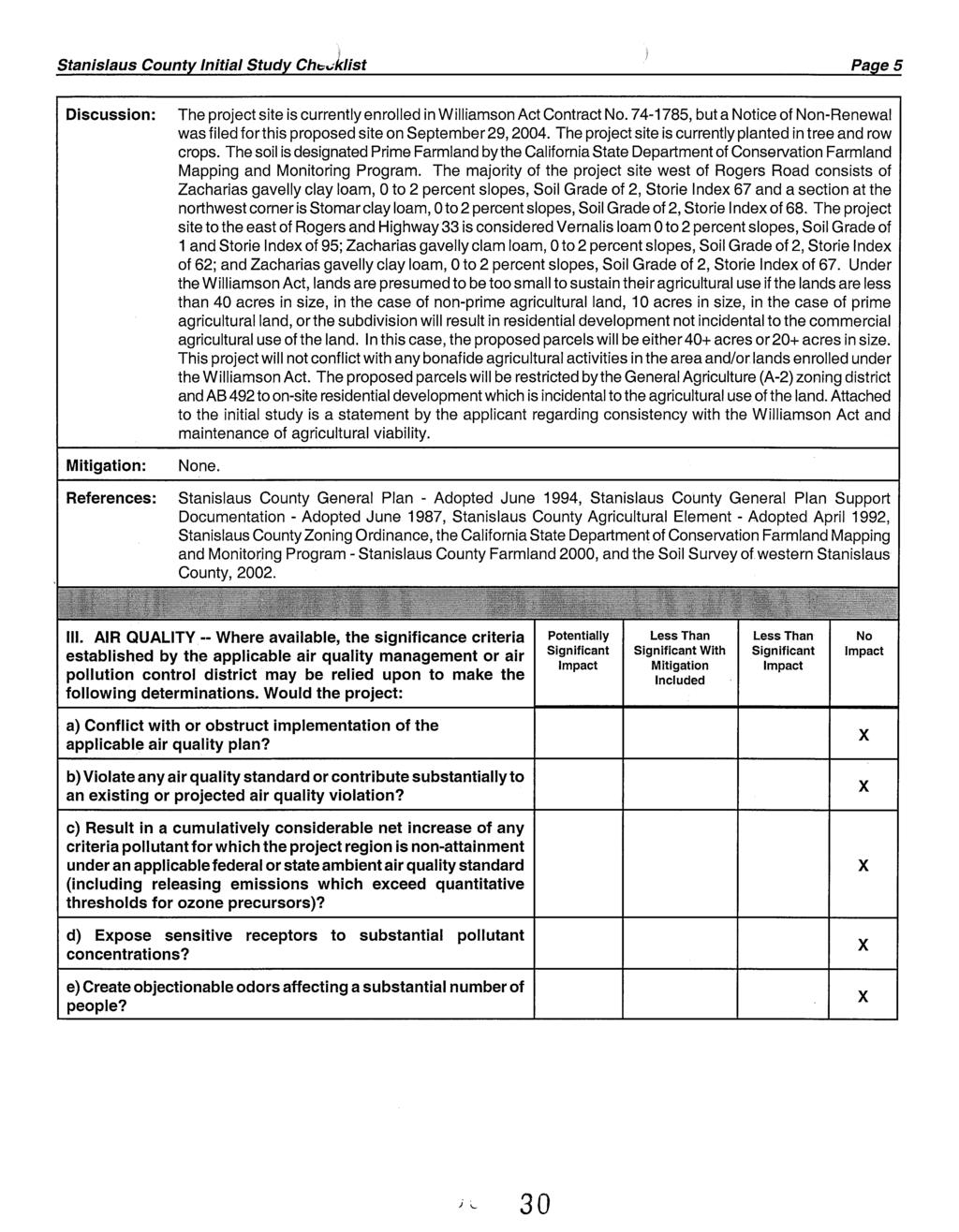
4
5
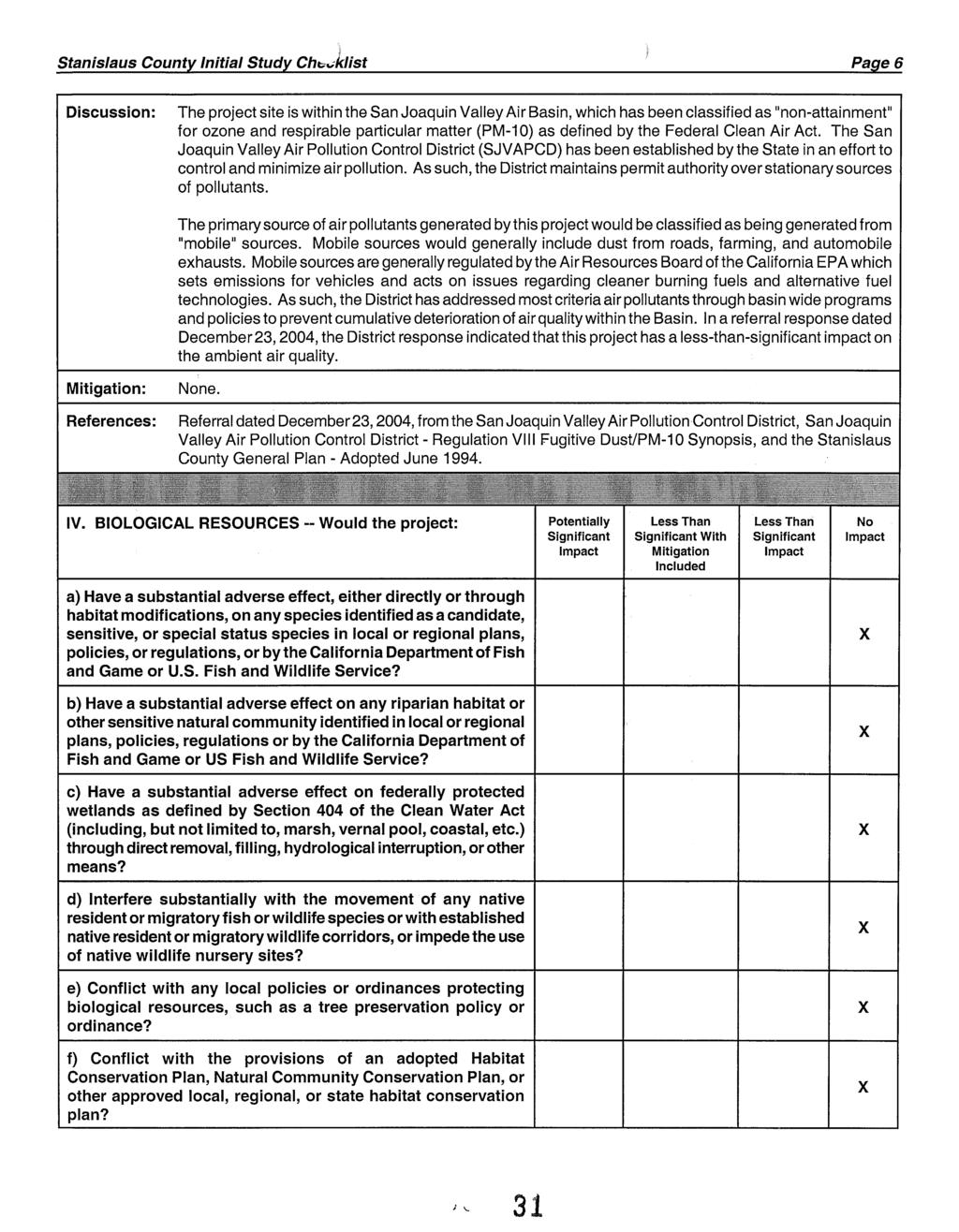
6
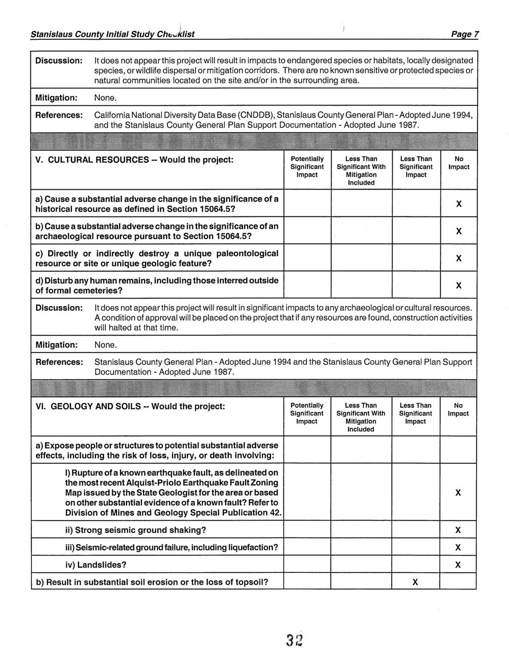
7
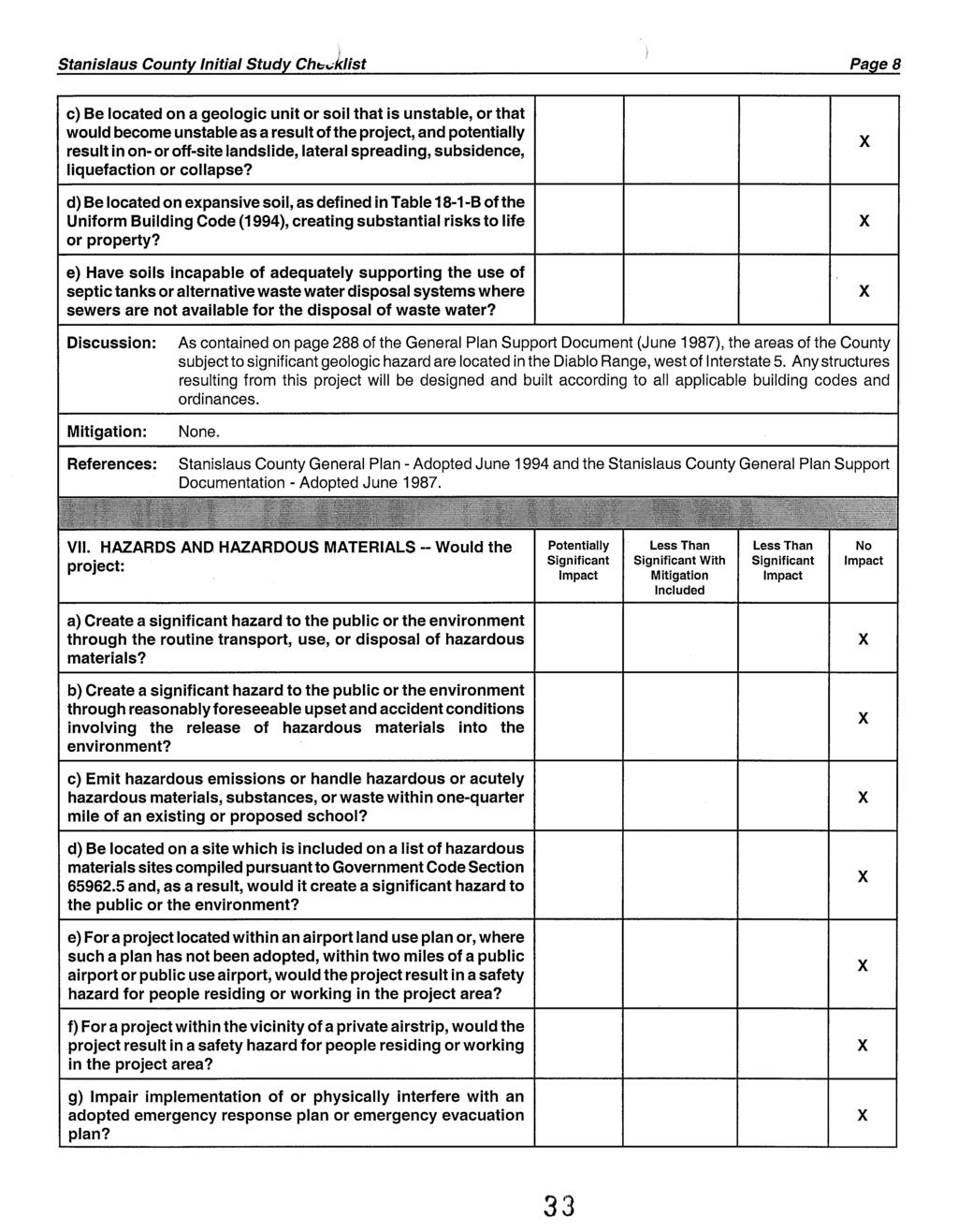
8
9
10
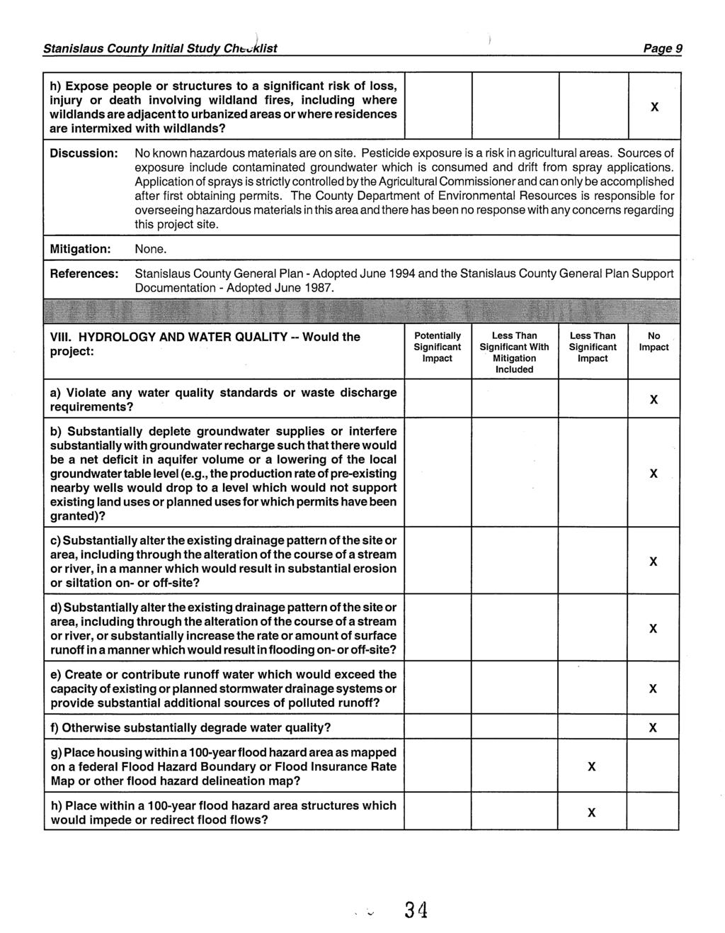
11
12
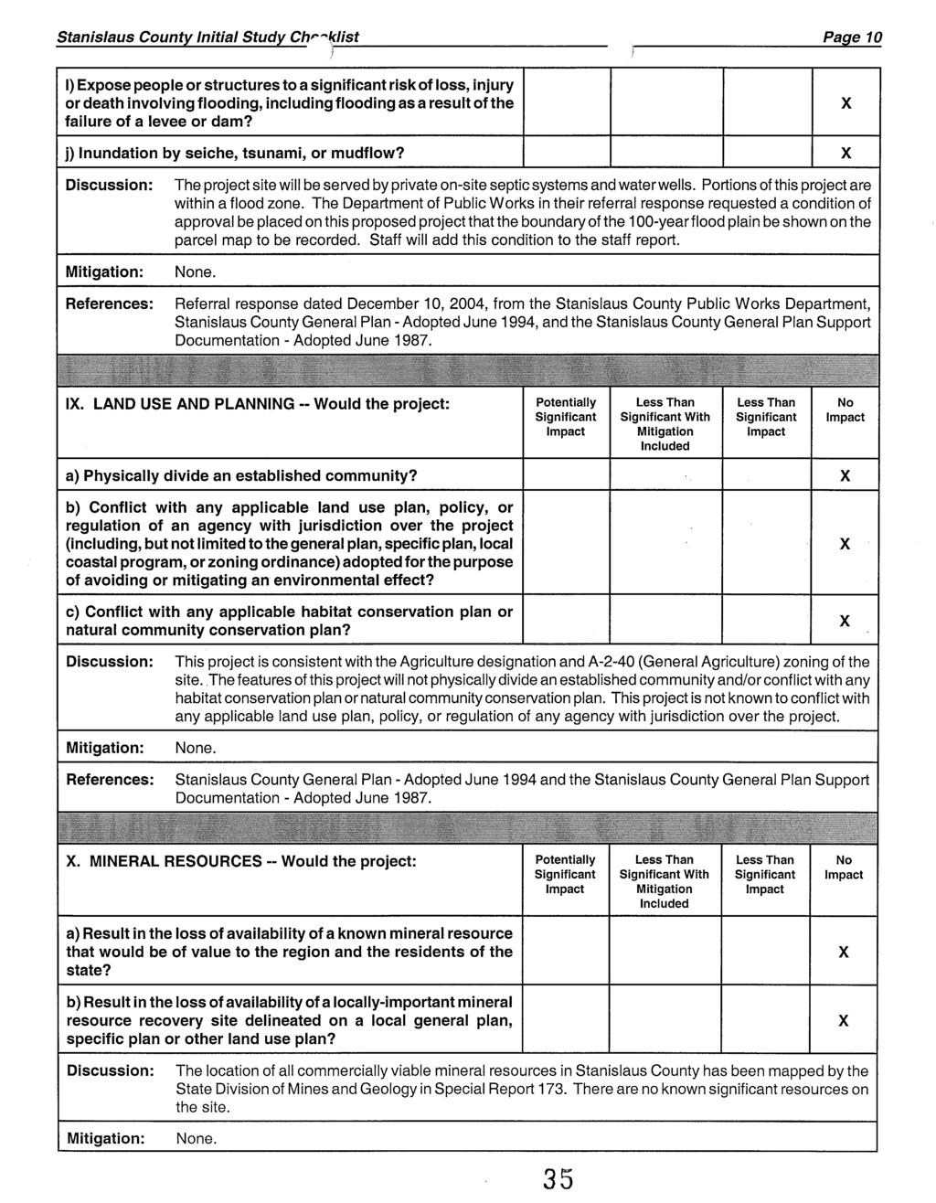
13 AS AMENDED BY THE PLANNING COMMISSION MAY 5, 2005 CONDITIONS OF APPROVAL VESTING TENTATIVE PARCEL MAP APPLICATION NO PATTERSON FROZEN FOODS Department of Public Works 1. The recorded parcel map shall be prepared by a licensed land surveyor or a registered civil engineer. 2. All existing non-public facilities and/or utilities that do not have lawful authority to occupy the road right of way shall be relocated onto private property upon the request of the Department of Public Works. 3. All structures not shown on the tentative parcel map shall be removed prior to the parcel map being recorded. 4. All irrigation and drainage easements shown on the tentative parcel map shall be shown on the final parcel map to be recorded. 5. All access easements as shown on the tentative parcel map shall be shown on the final map to be recorded. 6. That 50-foot public utility easements from Rogers Road or Baldwin Road to Parcels 9", 10, 11", 12", 15", 16" and the Remainder shall be shown on the parcel map to be recorded. These public utility easements shall be within the proposed access easements as shown on the tentative parcel map. 7. A statement on the final parcel map that the access roads are private, non-county maintained. 8. The boundaries of and area within the 100-year flood plain shall be shown on the final parcel map to be recorded. 9. Prior to the final parcel map being recorded, a homeowner s association shall be formed and the necessary documents recorded that specify maintenance of all private access roads will be the sole responsibility of the property owners. A copy of the recorded homeowner s association shall be provided to the Department of Public Works and the Department of Planning and Community Development. 9. Prior to the final parcel map being recorded, a Maintenance Agreement shall be executed and recorded that specifies maintenance of all private access roads will be the sole responsibility of the property owners. A copy of the recorded agreement shall be provided t the Department of Public Works and the Department of Planning and Community Development prior to recording the final parcel map.
14 PM Conditions of Approval May 5, 2005 Page 2 Planning and Community Development 10. Prior to the issuance of building permits for a dwelling, the owner/developer shall pay a fee of $ per dwelling to the County Sheriff s Department. 11. Any construction resulting from this project shall comply with standardized dust controls adopted by the San Joaquin Valley Air Pollution Control District. 12. Developer shall pay all Public Facilities Impact Fees and Fire Facilities Fees as adopted by Resolution of the Board of Supervisors. The Fees shall be payable at the time of issuance of a building permit for any construction in the development project and shall be based on the rates in effect at the time of building permit issuance. 13. The subdivider is required to defend, indemnify, or hold harmless the County, its officers and employees from any claim, action, or proceedings against the County to set aside the approval of the map as set forth in Government Code Section The County shall promptly notify the subdivider of any claim, action, or proceeding to set aside the approval and shall cooperate fully in the defense. 14. Prior to the issuance of the Notice of Determination, the applicant shall pay, within five working days of Planning Commission approval, a filing fee of $50.00 to Stanislaus County Clerk/Recorder care of the Planning Department. Should the "De Minimis" finding be found invalid for any reason, the applicant/developer shall be responsible for payment of Department of Fish and Game Fees. 15. Pursuant to Section 404 of the Clean Water Act, prior to construction, the developer shall be responsible for contacting the US Army Corps of Engineers to determine if any "wetlands, "waters of the United States, or other areas under the jurisdiction of the Corps of Engineers are present on the project site, and shall be responsible for obtaining all appropriate permits or authorizations from the Corps, including all necessary water quality certifications, if necessary. 16. Pursuant to Section 1600 and 1603 of the California Fish and Game Code, prior to construction, the developer shall be responsible for contacting the California Department of Fish and Game and shall be responsible for obtaining all appropriate stream-bed alteration agreements, permits or authorizations, if necessary. 17. Pursuant to State Water Resources Control Board Order DWQ and National Pollutant Discharge Elimination System (NPDES) General Permit No. CAS000002, prior to construction, the developer shall be responsible for contacting the California Regional Water Quality Control Board to determine if a "Notice of Intent" is necessary, and shall prepare all appropriate documentation, including a Storm Water Pollution Prevention Plan (SWPPP). Once complete, and prior to construction, a copy of the SWPPP Pollution Prevention Plan shall be submitted to the Stanislaus County Department of Public Works.
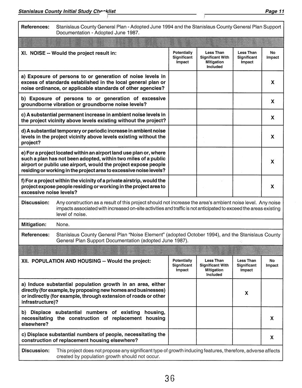
15 PM Conditions of Approval May 5, 2005 Page Pursuant to the federal and state Endangered Species Acts, prior to construction, the developer shall be responsible for contacting the US Fish and Wildlife Service and California Department of Fish and Game to determine if any special status plant or animal species are present on the project site, and shall be responsible for obtaining all appropriate permits or authorizations from these agencies, if necessary. 19. The final recorded map shall contain the following statement: All persons purchasing lots within the boundaries of this approved map should be prepared to accept the inconveniences associated with the agricultural operations, such as noise, odors, flies, dust or fumes. Stanislaus County has determined that such inconveniences shall not be considered to be a nuisance if agricultural operations are consistent with accepted customs and standards. West Stanislaus Fire Protection District 20. Water supplies for fire protection must meet Stanislaus County Standards with regard to hydrants, distribution system, storage, pumps, flow and emergency backup. 21. All buildings more than 120 square feet in size, shall be automatic fire sprinkled to National Fire Protection Association No All locked areas shall be provided with Fire Department Standard Access Key System (Knox). Stanislaus Consolidated Fire 23. Prior to development of any parcel obtaining access from an access easement, the easement shall be upgraded to an all-weather surface and bridges shall be engineered showing compliance with Cal Trans standards. Turlock Irrigation District 23. The owner/developer must apply for a facility change for any pole or electrical facility relocation. Facility changes are performed at developer s expense ****** (I:\Staffrpt\PM\2004\PM Patterson Frozen Foods\pm PattersonFrozenFoods.sr.wpd)
16
17
18
19
20
21
22
23
24
25
26
27
28
29
30
31
32
33
34
35
36
37
38
39
40
41
42
 As Amended by the Planning Commission June 16, 2005 CONDITIONS OF APPROVAL TENTATIVE PARCEL MAP APPLICATION NO. 2002-28 NANCY ABDALLAH Department of Public Works 1. The recorded parcel map shall be prepared
 AS AMENDED BY THE PLANNING COMMISSION MAY 19, 2005 CONDITIONS OF APPROVAL VESTING TENTATIVE PARCEL MAP APPLICATION NO. 2005-04 SUMMIT CORPORATE CENTER Department of Public Works 1. The recorded parcel
FORM Seven (7) copies of the completed application information forms (attached) which all owners must sign.
 copies of the completed application information forms (attached) which all owners must sign.") WILLIAMSON ACT CONTRACT CANCELLATION SAN JOAQUIN COUNTY COMMUNITY DEVELOPMENT DEPARTMENT 1810 E. HAZELTON AVENUE, STOCKTON CA 95205 BUSINESS PHONE: (209) 468-3121 Business Hours: 8:00 a.m. to 5:00 p.m.
WILLIAMSON ACT CONTRACT CANCELLATION SAN JOAQUIN COUNTY COMMUNITY DEVELOPMENT DEPARTMENT 1810 E. HAZELTON AVENUE, STOCKTON CA 95205 BUSINESS PHONE: (209) 468-3121 Business Hours: 8:00 a.m. to 5:00 p.m.
APPLICATION PROCESSING. CHECK WITH STAFF - Development Services Staff will explain the requirements and procedures to you.
 PLANNED DEVELOPMENT ZONE 1810 E. HAZELTON AVENUE, STOCKTON CA 95205 BUSINESS PHONE: (209) 468-3121 Business Hours: 8:00 a.m. to 5:00 p.m. (Monday through Friday) STEP 1 STEP 2 FEE FORM DEED SERVICES APPLICATION
(b) (c) (d) Address City, Zip Phone. (b) (c) (d) Address City, Zip Phone 6. LIST THE NUMBER AND USE OF ALL EXISTING STRUCTURES ON PROPERTY:
 (c) (d) Address City, Zip Phone. (b) (c) (d) Address City, Zip Phone 6. LIST THE NUMBER AND USE OF ALL EXISTING STRUCTURES ON PROPERTY:") DEPARTMENT OF PLANNING AND COMMUNITY DEVELOPMENT 1010 10 TH Street, Suite 3400, Modesto, CA 95354 Planning Phone: (209) 525-6330 Fax: (209) 525-5911 Building Phone: (209) 525-6557 Fax: (209) 525-7759 Form
DEPARTMENT OF PLANNING AND COMMUNITY DEVELOPMENT 1010 10 TH Street, Suite 3400, Modesto, CA 95354 Planning Phone: (209) 525-6330 Fax: (209) 525-5911 Building Phone: (209) 525-6557 Fax: (209) 525-7759 Form
APPLICATION CHECKLIST
 DEPARTMENT OF PLANNING AND COMMUNITY DEVELOPMENT 1010 10TH Street, Suite 3400, Modesto, CA 95354 Phone: 209.525.6330 Fax: 209.525.5911 Form Available Online: http://www.stancounty.com/planning/applications.shtm
APPLICATION PROCESSING
 MAJOR SUBDIVISION 1810 E. HAZELTON AVENUE, STOCKTON CA 95205 BUSINESS PHONE: (209) 468-3121 BUSINESS HOURS: 8:00 A.M. TO 5:00 P.M..(Monday through Friday) APPLICATION PROCESSING STEPS STEP 1 STEP 2 CHECK
ATTACHMENT B: CONDITIONS OF APPROVAL. Overholtzer Tentative Parcel Map Case No. 08TPM /TPM 14,744 Date: October 13, 2010
 Overholtzer Tenative Parcel Map, 08TPM-00000-00003 Page B-1 I. PROJECT DESCRIPTION ATTACHMENT B: CONDITIONS OF APPROVAL Overholtzer Tentative Parcel Map Case No. 08TPM-00000-0003/TPM 14,744 Date: October
FEE The staff will let you know the current cost of filing an application. Make checks payable to the San Joaquin County Treasurer.
 VARIANCE 1810 E. HAZELTON AVENUE, STOCKTON CA 95205 BUSINESS PHONE: (209) 468-3121 Business Hours: 8:00 a.m. to 5:00 p.m. (Monday through Friday) STEP 1 STEP 2 APPLICATION PROCESSING STEPS CHECK WITH STAFF
STANISLAUS COUNTY PLANNING COMMISSION STAFF REPORT
 STANISLAUS COUNTY PLANNING COMMISSION STAFF REPORT GENERAL PLAN AMENDMENT APPLICATION NO. 2005-08, COMMUNITY PLAN AMENDMENT APPLICATION NO- 2005-03, VESTING TENTATIVE SUBDIVISION MAP APPLICATION NO. 2005-04
APPLICATION PROCESSING STEPS STEP 1 CHECK WITH STAFF
 APPLICATION PROCESSING STEPS STEP 1 CHECK WITH STAFF - Development Services Staff will explain the requirements and procedures to you. However, before filing an application with the Community Development
Referral Early Consultation
 DEPARTMENT OF PLANNING AND COMMUNITY DEVELOPMENT 1010 10 TH Street, Suite 3400, Modesto, CA 95354 Planning Phone: (209) 525-6330 Fax: (209) 525-5911 Building Phone: (209) 525-6557 Fax: (209) 525-7759 Date:
PLANNING COMMISSION STAFF REPORT June 18, 2015
 Community Development Department Planning Division 1600 First Street + P.O. Box 660 Napa, CA 94559-0660 (707) 257-9530 PLANNING COMMISSION STAFF REPORT June 18, 2015 AGENDA ITEM 7.B. PL15-0052 PM, GASSER
CITY OF CORNING TENTATIVE MAPS
 CITY OF CORNING TENTATIVE MAPS APPLICANT S GUIDE TO PROCEDURES WHAT IS A TENTATIVE MAP? A division of land for the purpose of sale, lease, or finance requires submittal of a map for City approval showing
SEQRA (For Land Surveyors) Purpose of this Presentation
 Purpose of this Presentation") SEQRA (For Land Surveyors) Purpose of this Presentation Understand the basics and legal requirements of SEQRA Recognize the role that Land Surveyors play in the SEQRA Identify the problems posed by SEQRA
SEQRA (For Land Surveyors) Purpose of this Presentation Understand the basics and legal requirements of SEQRA Recognize the role that Land Surveyors play in the SEQRA Identify the problems posed by SEQRA
Chapter HABITAT CONSERVATION PLAN / NATURAL COMMUNITY CONSERVATION PLAN IMPLEMENTATION ORDINANCE
 Chapter 15.108 HABITAT CONSERVATION PLAN / NATURAL COMMUNITY CONSERVATION PLAN IMPLEMENTATION ORDINANCE Sections: 15.108.010 Purpose. 15.108.020 Definitions. 15.108.030 Applicability 15.108.040 Responsibility
MS MINOR SUBDIVISION TREVITHICK
 MS-02-015 341.12 MINOR SUBDIVISION TREVITHICK A request by Danny Trevithick for a one-lot Minor Subdivision on five acres. The property is zoned A-35 (Agricultural) District and is located ¼ mile south
OWNER-INITIATED MERGER OF PARCELS APPLICATION
 REQUIREMENTS TO THE APPLICANT: OWNER-INITIATED MERGER OF PARCELS APPLICATION Please provide the following materials for your application. A complete application package will expedite your request for a
COMMUNITY DEVELOPMENT AND RESOURCES COMMISSION OF THE CITY OF ATWATER
 COMMUNITY DEVELOPMENT AND RESOURCES COMMISSION OF THE CITY OF ATWATER RESOLUTION NO. 033-17 A RESOLUTION OF THE COMMUNITY DEVELOPMENT AND RESOURCES COMMISSION OF THE CITY OF ATWATER RECOMMENDING APPROVAL
1. The reason provided for the opposing votes was that the two commissioners wanted something else to be developed on their parcel.
 Agenda Item #6.2 SUBJECT: PUBLIC HEARING - APPEAL OF PLANNING COMMISSION DECISION DENYING THE APPROVAL OF THE TENTATIVE PARCEL MAP, CONDITIONAL USE PERMIT, AND SITE AND ARCHITECTURAL REVIEW FOR THE CONSTRUCTION
Referral Early Consultation
 DEPARTMENT OF PLANNING AND COMMUNITY DEVELOPMENT 1010 10 th Street, Suite 3400, Modesto, CA 95354 Phone: 209.525.6330 Fax: 209.525.5911 Date: December 15, 2017 Referral Early Consultation To: Distribution
APPLICATION INFORMATION
 DEPARTMENT OF PLANNING AND COMMUNITY DEVELOPMENT 1010 10 TH Street, Suite 3400, Modesto, CA 95354 Planning Phone: (209) 525-6330 Fax: (209) 525-5911 Building Phone: (209) 525-6557 Fax: (209) 525-7759 Form
Applicant Address: 3325 Longview Drive, St 311. State/Zip: Ca/ Phone: (916)
") Planning Application Form Cover Sheet This application form is required as part of any planning development request. Other required items are indicated on the accompanying instructions and checklists.
Planning Application Form Cover Sheet This application form is required as part of any planning development request. Other required items are indicated on the accompanying instructions and checklists.
City of San Juan Capistrano Agenda Report
 ITEM F2 City of San Juan Capistrano Agenda Report TO: FROM: Planning Commission Prepared & Submitted by: David Contreras~ting Assistant Development Services Director c;:::e._,~.y.. Reviewed by: Sergio
CHAPTER County of Alameda Onsite Wastewater Treatment Systems Ordinance
 The Alameda County Board of Supervisors hereby finds and declares: A. Modifications to Chapter 15.18 of the Alameda County General Ordinance Code are necessary to comply with new standards and regulations
Eaton County Stormwater Management Maintenance Covenant for Private Storm Drain Systems
 Eaton County Stormwater Management Maintenance Covenant for Private Storm Drain Systems By and between:, Eaton County Drain Commissioner and Prepared by: 1045 Independence Boulevard Charlotte, MI 48813
RESOLUTION OF THE BOARD OF SUPERVISORS OF ORANGE COUNTY, CALIFORNIA APPROVING VESTING TENTATIVE TRACT MAP December 13, 2016
 RESOLUTION OF THE BOARD OF SUPERVISORS OF ORANGE COUNTY, CALIFORNIA APPROVING VESTING TENTATIVE TRACT MAP 17522 December 13, 2016 WHEREAS, Yorba Linda Estates, LLC, OC 33, LLC and the Nicholas/Long Family
Trio Petroleum, Inc. (PLN010302)
") LYNNE MOUNDAY ZONING ADMINISTRATOR STATE OF CALIFORNIA COUNTY OF MONTEREY RESOLUTION NO. 010302 A.P.# 424-091-021-000 In the matter of the application of Trio Petroleum, Inc. (PLN010302) FINDINGS & DECISION
LYNNE MOUNDAY ZONING ADMINISTRATOR STATE OF CALIFORNIA COUNTY OF MONTEREY RESOLUTION NO. 010302 A.P.# 424-091-021-000 In the matter of the application of Trio Petroleum, Inc. (PLN010302) FINDINGS & DECISION
PROJECT ADDRESS ASSESSOR S PARCEL NUMBER G.P. LAND USE DESIGNATION ZONING DISTRICT FLOOD HAZARD ZONE SITE ACREAGE AIRPORT SAFETY ZONE?
 TYPE OR PRINT CLEARLY Submit Completed Applications to: City of Corning Planning Dept. 794 Third Street Corning, CA 96021 PROJECT ADDRESS ASSESSOR S PARCEL NUMBER G.P. LAND USE DESIGNATION ZONING DISTRICT
DEER RIVER COMMERCIAL PARK SUBDIVISION
 DEER RIVER COMMERCIAL PARK SUBDIVISION Engineering Comments: Must comply with the Mobile County Flood Damage Prevention Ordinance. Development shall be designed to comply with the storm water detention
1.0 REQUEST. SANTA BARBARA COUNTY ZONING ADMINISTRATOR Coastal Zone Staff Report for Vincent New Single-Family Dwelling & Septic System
 SANTA BARBARA COUNTY ZONING ADMINISTRATOR Coastal Zone Staff Report for Vincent New Single-Family Dwelling & Septic System Hearing Date: February 26, 2007 Supervisorial District: First Staff Report Date:
:= Information Included
 DEPARTMENT OF PLANNING AND COMMUNITY DEVELOPMENT 1010 10th Street, Suite 3400, Modesto, CA 95354 Planning Phone: (209) 525-6330 Fax: (209) 525-5911 Building Phone: (209) 525-6557 Fax: (209) 525-7759 Form
CHAPTER 5 ENVIRONMENTAL COMPLIANCE PLAN REQUIREMENTS
 CHAPTER 5 5.1 INTRODUCTION As previously discussed, land-disturbing activities in Henrico County are subject to the requirements of numerous environmental programs as a result of mandates imposed by various
What is a Conditional Use? When is a Conditional Use Necessary? Who decides if I will get a Conditional Use Permit
 What is a Conditional Use? A conditional use is a land use or development that would not be appropriate generally but may be allowed with appropriate controls upon a finding that certain conditions as
EXHIBIT "A" THE PRESERVE AT WILDERNESS LAKE COMMUNITY DEVELOPMENT DISTRICT 5844 Old Pasco Road, Suite 100, Wesley Chapel, Florida 33544
 EXHIBIT "A" THE PRESERVE AT WILDERNESS LAKE COMMUNITY DEVELOPMENT DISTRICT 5844 Old Pasco Road, Suite 100, Wesley Chapel, Florida 33544 NATURAL AREAS POLICY STATEMENT The following is the policy statement
APPLICATION FOR PERMIT: (Pursuant to Ord & Reso ) 4d Habitat Loss Permit Vegetation Removal Tree Removal. Address:
 4d Habitat Loss Permit Vegetation Removal Tree Removal. Address:") CITY OF ESCONDIDO Planning Division 201 North Broadway Escondido, CA 92025-2798 (760) 839-4671 Fax: (760) 839-4313 APPLICATION FOR PERMIT: (Pursuant to Ord. 91-54 & Reso. 94-436) Case No: FOR INTERNAL
CITY OF ESCONDIDO Planning Division 201 North Broadway Escondido, CA 92025-2798 (760) 839-4671 Fax: (760) 839-4313 APPLICATION FOR PERMIT: (Pursuant to Ord. 91-54 & Reso. 94-436) Case No: FOR INTERNAL
MINOR SUBDIVISION INFORMATION
 A. POINTS OF CONTACT: MINOR SUBDIVISION INFORMATION Surveyor: Address: Phone #: Fax # E-Mail Address: Representative (If different from applicant): Address: Phone #: Fax # E-Mail Address: B. GENERAL INFORMATION:
Preliminary Subdivision Application (Minor) (Three (3) lots or less)
 (Three (3) lots or less)") Gunnison City Offices www.gunnisoncity.org 38 West Center Gunnison, Utah 84634 (435) 528 7969 Date of Application: Preliminary Subdivision Application (Minor) (Three (3) lots or less) APPLICANT INFORMATION
Gunnison City Offices www.gunnisoncity.org 38 West Center Gunnison, Utah 84634 (435) 528 7969 Date of Application: Preliminary Subdivision Application (Minor) (Three (3) lots or less) APPLICANT INFORMATION
1. Adopted the required findings for the project specified in Attachment A of the staff report dated February 6, 2004, including CEQA findings;
 February 19, 2004 Joan L. Jamieson P.O. Box 741 ZONING ADMINISTRATOR Solvang, CA 93441 HEARING OF FEBRUARY 17, 2004 RE: Eubanks Lot Line Adjustment, 03LLA-00000-00013 Hearing on the request of Joan Jamieson,
Preliminary Subdivision Application (Major) (Four (4) lots or more)
 (Four (4) lots or more)") Gunnison City Offices www.gunnisoncity.org 38 West Center Gunnison, Utah 84634 (435) 528 7969 Date of Application: Preliminary Subdivision Application (Major) (Four (4) lots or more) APPLICANT INFORMATION
Gunnison City Offices www.gunnisoncity.org 38 West Center Gunnison, Utah 84634 (435) 528 7969 Date of Application: Preliminary Subdivision Application (Major) (Four (4) lots or more) APPLICANT INFORMATION
# 1 HOLDOVER Revised SUB CANAL SUBDIVISION
 CANAL SUBDIVISION Engineering Comments: Label each Lot showing the required minimum finished floor elevation (MFFE). It appears that Lots 2, 3 & 4 are located in the AE Flood Zone; add a note to the plat
ARTICLE V. PRELIMINARY PLAT
 ARTICLE V. PRELIMINARY PLAT PAGE 13 SECTION A. PURPOSE. The purpose of the preliminary plat is to allow the Planning and Zoning Commission to review overall platting of the tract and street patterns within
SANTA BARBARA COUNTY ZONING ADMINISTRATOR STAFF REPORT November 20, 2015
 SANTA BARBARA COUNTY ZONING ADMINISTRATOR STAFF REPORT November 20, 2015 PROJECT: Acquistapace Tentative Parcel Map HEARING DATE: December 7, 2015 STAFF/PHONE: Dana Eady, (805) 934-6266 GENERAL INFORMATION
CHAPTER 10 Planned Unit Development Zoning Districts
 CHAPTER 10 Planned Unit Development Zoning Districts Section 10.1 Intent and Purpose The Planned Unit Development (PUD) districts are intended to offer design flexibility for projects that further the
DEPARTMENT OF FISH AND WILDLIFE ENVIRONMENTAL FILING FEES (Fish and Game Code 711.4)
") PARCEL MAP PROCESS DEPARTMENT OF PLANNING AND BUILDING SERVICES 707 Nevada Street, Suite 5 Susanville, CA 96130-3912 (530) 251-8269 (530) 251-8373 (fax) www.co.lassen.ca.us A subdivision is any division
PARCEL MAP PROCESS DEPARTMENT OF PLANNING AND BUILDING SERVICES 707 Nevada Street, Suite 5 Susanville, CA 96130-3912 (530) 251-8269 (530) 251-8373 (fax) www.co.lassen.ca.us A subdivision is any division
Attached is a Clinton Township Zoning Permit Application and requirements for issuance of a permit.
 To Whom It May Concern: Attached is a Clinton Township Zoning Permit Application and requirements for issuance of a permit. The fee for the permit application is $75.00, which shall be made payable to
APPLICATION PROCESSING. Seven (7) copies of a site plan (see attached). Seven (7) copies of the recorded deed(s) of the properties involved.
 copies of a site plan (see attached). Seven (7) copies of the recorded deed(s) of the properties involved.") REVERSION OF ACREAGE San Joaquin County Community Development Department 1810 East Hazelton Avenue, Stockton CA 95205 Telephone: (209) 468-3121 Business Hours: 8:00 a.m. to 5:00p.m. (Monday through Friday,
REVERSION OF ACREAGE San Joaquin County Community Development Department 1810 East Hazelton Avenue, Stockton CA 95205 Telephone: (209) 468-3121 Business Hours: 8:00 a.m. to 5:00p.m. (Monday through Friday,
MINOR ALTERATIONS PROCEDURE
 Planning Division Staff (415) 435-7390 www.townoftiburon.org SUPPLEMENTAL APPLICATION FORM SITE PLAN & ARCHITECTURAL REVIEW FOR MINOR ALTERATION MINOR ALTERATIONS In accordance with Title IV, Chapter 16,
Conditions of Approval Tentative Map Amendment -Shadowbrook January 11, 2016
 City of Manteca Community Development Department Conditions of Approval -Shadowbrook January 11, 2016 Project File Numbers: TSM 15-93 Project Name: Shadowbrook Amendment Project APN: 218-130-01, 04, 05,
Tentative Map Application Review Procedures
 FOR REFERENCE ONLY This page is not part of the application. Tentative Map Application Review Procedures The tentative map process in Churchill County is designed to provide a mechanism in order to divide
EL DORADO COUNTY DEVELOPMENT SERVICES ZONING ADMINISTRATOR STAFF REPORT TENTATIVE PARCEL MAP TIME EXTENSION
 EL DORADO COUNTY DEVELOPMENT SERVICES ZONING ADMINISTRATOR STAFF REPORT Agenda of: March 1, 2017 Item No.: Staff: 4.a. Rob Peters TENTATIVE PARCEL MAP TIME EXTENSION FILE NO.: APPLICANT: OWNER: ENGINEER:
APPLICATION PROCESSING STEPS
 LOT LINE ADJUSTMENT 1810 E. HAZELTON AVENUE, STOCKTON CA 95205 BUSINESS PHONE: (209) 468-3121 Business Hours: 8:00 a.m. to 5:00 p.m. (Monday through Friday) APPLICATION PROCESSING STEPS STEP 1 CHECK WITH
CHAPTER 352 COUNTY LAND PRESERVATION AND USE COMMISSIONS
 CHAPTER 352 COUNTY LAND PRESERVATION AND USE COMMISSIONS Referred to in 6B.3, 15E.111, 159.6, 173.3, 455B.275 Chapter does not invalidate ordinances existing on July 1, 1982, or require adoption of zoning
Encroachment Permit Application Instructions
 Encroachment Permit Application Instructions Imperial Irrigation District Real Estate Section Requirements for Encroachment Permit Application Any construction or operation activities on Imperial Irrigation
CITY OF CITRUS HEIGHTS Planning Department 6237 Fountain Square Drive Citrus Heights, CA (916)
") CITY OF CITRUS HEIGHTS Planning Department 6237 Fountain Square Drive Citrus Heights, CA 95621 (916) 725-2448 DATE: May 17, 2005 TO: Mike Evans Mike Williams 3111 Sunset Blvd. Suite One Baker-Williams
CITY OF CITRUS HEIGHTS Planning Department 6237 Fountain Square Drive Citrus Heights, CA 95621 (916) 725-2448 DATE: May 17, 2005 TO: Mike Evans Mike Williams 3111 Sunset Blvd. Suite One Baker-Williams
RESOLUTION NO. PC
 RESOLUTION NO. PC 13-1060 A RESOLUTION OF THE PLANNING COMMISSION OF THE CITY OF WEST HOLLYWOOD, APPROVING AN AMENDMENT TO A CONDITIONAL USE PERMIT, AND APPROVAL OF A DEVELOPMENT PERMIT AND PARKING USE
GENERAL PLAN DESIGNATIONS (Exhibit A): MDR (Medium Density Residential) Designation. SURROUNDING: MDR (Medium Density Residential) Designation
: MDR (Medium Density Residential) Designation. SURROUNDING: MDR (Medium Density Residential) Designation") STAFF REPORT March 3, 2015 PRJ #2014-007 PM #4201 CZ #2014-007 GENERAL PLAN DESIGNATIONS (Exhibit A): SITE: MDR (Medium Density Residential) Designation SURROUNDING: MDR (Medium Density Residential) Designation
STAFF REPORT March 3, 2015 PRJ #2014-007 PM #4201 CZ #2014-007 GENERAL PLAN DESIGNATIONS (Exhibit A): SITE: MDR (Medium Density Residential) Designation SURROUNDING: MDR (Medium Density Residential) Designation
TENTATIVE PARCEL MAP APPLICATION GUIDE TENTATIVE PARCEL MAP APPLICATION REQUIREMENTS
 TENTATIVE PARCEL MAP APPLICATION GUIDE SISKIYOU COUNTY PLANNING DIVISION 806 South Main Street, Yreka CA 96097 Phone: (530) 841-2100 / Fax: (530) 841-4076 TENTATIVE PARCEL MAP APPLICATION REQUIREMENTS
VARIANCE APPLICATION
 REQUIREMENTS TO THE APPLICANT: Please provide the following materials for your application. A complete application package will expedite your public hearing before the Planning and Preservation Commission.
BOUNDARY LINE ADJUSTMENT APPLICATION GUIDE
 BOUNDARY LINE ADJUSTMENT APPLICATION GUIDE SISKIYOU COUNTY PLANNING DIVISION 806 South Main Street, Yreka CA 96097 Phone: (530) 841-2100 / Fax: (530) 841-4076 WHAT IS A BOUNDARY LINE ADJUSTMENT? A Boundary
EL DORADO COUNTY PLANNING AND BUILDING DEPARTMENT ZONING ADMINISTRATOR STAFF REPORT TENTATIVE PARCEL MAP TIME EXTENSION
 EL DORADO COUNTY PLANNING AND BUILDING DEPARTMENT ZONING ADMINISTRATOR STAFF REPORT Agenda of: June 21, 2017 Item No.: Staff: 5.a. Evan Mattes TENTATIVE PARCEL MAP TIME EXTENSION FILE NO.: APPLICANT: ENGINEER:
RESOLUTION NO. P15-07
 RESOLUTION NO. P15-07 A RESOLUTION OF THE PLANNING COMMISSION OF THE CITY OF SANTA CLARITA APPROVING MASTER CASE 15-035, CONDITIONAL USE PERMIT 15-002, TO ALLOW FOR THE SALES OF LIQUOR AND SPIRITS WITHIN
Article II. - Right to Farm.
 Sec. 30-20. - Short title. Sec. 30-21. - Findings. Sec. 30-22. - Relationship to other laws. Sec. 30-23. - Schedule of fees and charges. Sec. 30-24. - Definitions. Sec. 30-25. - Nuisance Agricultural operation.
ORDINANCE NO. 118 SECTION 3. DISCLOSURE REQUIREMENTS Ð NEW CONSTRUCTION
 ORDINANCE NO. 118 AN ORDINANCE OF MILFORD TOWNSHIP, BUCKS COUNTY, PENNSYLVANIA, REQUIRING SELLERS OF NEW RESIDENTIAL PROPERTY TO DISPLAY THE FINAL APPROVED SUBDIVISION PLAN, TO SPECIFICALLY SHOW THIS PLAN
Community Development Department Planning Division 1600 First Street + P.O. Box 660 Napa, CA (707)
") Community Development Department Planning Division 1600 First Street + P.O. Box 660 Napa, CA 94559-0660 (707) 257-9530 PLANNING COMMISSION STAFF REPORT MARCH 3, 2016 AGENDA ITEM # 7.B. File No. 15-0158
Community Development Department Planning Division 1600 First Street + P.O. Box 660 Napa, CA 94559-0660 (707) 257-9530 PLANNING COMMISSION STAFF REPORT MARCH 3, 2016 AGENDA ITEM # 7.B. File No. 15-0158
Site Development Review for
 Site Development Review for Guide Agriculture Caretaker Dwelling WHAT IS IT? Site Development Review for Agricultural Caretaker Dwelling(s) ensures that placement of new or continued occupancy of temporary
MEMORANDUM. TERESA McCLISH, COMMUNITY DEVELOPMENT DIRECTOR
 MEMORANDUM TO: FROM: BY: PLANNING COMMISSION TERESA McCLISH, COMMUNITY DEVELOPMENT DIRECTOR MATTHEW DOWNING, ASSISTANT PLANNER SUBJECT: CONSIDERATION OF TENTATIVE PARCEL MAP CASE NO. 14-002; SUBDIVISION
SANTA BARBARA COUNTY ZONING ADMINISTRATOR STAFF REPORT August 30, 2007
 SANTA BARBARA COUNTY ZONING ADMINISTRATOR STAFF REPORT August 30, 2007 PROJECT: Detrana Entry Gates HEARING DATE: October 22, 2007 STAFF/PHONE: Sarah Clark, (805) 568-2059 GENERAL INFORMATION Case No.:
FILING REQUIREMENTS FOR SUBMITTING APPLICATIONS
 S T A N I S L A U S L A F C O Stanislaus Local Agency Formation Commission 1010 10th Street, 3 rd Floor Modesto, CA 95354 (209) 525-7660 FAX (209) 525-7643 www.stanislauslafco.org FILING REQUIREMENTS FOR
Chapter 35 - PROTECTION OF AGRICULTURAL LAND*
 Chapter 35 - PROTECTION OF AGRICULTURAL LAND* Sections: 35-1 - Short title. 35-2 - Findings. 35-3 - Relationship to other laws. 35-4 - Schedule of fees and charges. 35-5 - Definitions. 35-6 - Nuisance
Appendix A Major Federal, State, and Local Permits or Approvals
 TransWest Express EIS Appendix A Major Federal, State, and Local s or Approvals TransWest Express EIS Appendix A A-1 FEDERAL National Environmental Policy Act (NEPA) Compliance Federal action: to grant
YELLOWSTONE COUNTY BOARD OF PLANNING FINDINGS OF FACT
 YELLOWSTONE COUNTY BOARD OF PLANNING FINDINGS OF FACT The City-County Planning staff has prepared the Findings of Fact for the Aspen Ridge Subdivision, 2 nd Filing. These findings are based on the preliminary
# 14 SUB CANAL SUBDIVISION
 CANAL SUBDIVISION Engineering Comments: Label each Lot showing the required minimum finished floor elevation (MFFE). It appears that Lots 2, 3 & 4 are located in the AE Flood Zone; add a note to the plat
CITY OF LAGUNA BEACH COMMUNITY DEVELOPMENT DEPARTMENT STAFF REPORT
 CITY OF LAGUNA BEACH COMMUNITY DEVELOPMENT DEPARTMENT STAFF REPORT AGENDA ITEM: No. 10 DATE: 1211 0108 TO: 1 PLANNING CONIMISSION CASE: APPLICANT: LOCATION: ENVIRONMENTAL STATUS: PREPARED BY: Tentative
TENTATIVE PARCEL MAP TIME EXTENSION
 EL DORADO COUNTY DEVELOPMENT SERVICES ZONING ADMINISTRATOR STAFF REPORT Agenda of: October 15, 2008 Item No.: Staff: 4.a. Mel Pabalinas TENTATIVE PARCEL MAP TIME EXTENSION APPLICATION FILE NO.: APPLICANT:
RESOLUTION R
 RESOLUTION R2014-142 RESOLUTION OF THE CITY COUNCIL OF THE CITY OF NAPA, STATE OF CALIFORNIA, APPROVING A USE PERMIT TO AUTHORIZE THE USE OF SMALL LOT DEVELOPMENT STANDARDS AND FLAG LOT DEVELOPMENT STANDARDS;
PRINT NAMES OF BUYERS AS ARE THEY ARE TO APPEAR ON DEED (WITH MIDDLE INITIALS, ETC.)
") Diamond Development, LLC 309 E. 1st Street Ankeny, IA 50021 LOT PURCHASE AGREEMENT FOR PINE VIEW ESTATES PLAT 3 SUBDIVISION Buyer(s) First, Middle, Last or Full Company Name Social Security #/Federal ID#
Diamond Development, LLC 309 E. 1st Street Ankeny, IA 50021 LOT PURCHASE AGREEMENT FOR PINE VIEW ESTATES PLAT 3 SUBDIVISION Buyer(s) First, Middle, Last or Full Company Name Social Security #/Federal ID#
SUMMARY: The proposed project includes two basic components:
 MONTEREY COUNTY SUBDIVISION COMMITTEE MEETING: March 11, 2004 AGENDA NO.: 1 SUBJECT: Carmel Valley Ranch, PLN 020280 - Combined Development Permit consisting : 1) Standard Subdivision Vesting Tentative
This division may be cited as the Subdivision Map Act.
 CALIFORNIA CODES GOVERNMENT CODE SECTION 66410-66413.5 66410. This division may be cited as the Subdivision Map Act. 66411. Regulation and control of the design and improvement of subdivisions are vested
THE BLUFFS AT CYPRESS CREEK SUBDIVISION, PHASE ONE
 THE BLUFFS AT CYPRESS CREEK SUBDIVISION, PHASE ONE Engineering Comments: Shipyard Road shall be constructed to City Standard up through proposed Cypress Park Drive. Show Minimum FFE on plans and plat.
City of San Juan Capistrano Supplemental Agenda Report
 City of San Juan Capistrano Supplemental Agenda Report TO: FROM: DATE: SUBJECT: Planning Commission Development Services Department... / Submitted by: Charles View, Development Services Dire ct~.. J,J._
CANNABIS APPLICATION CHECKLIST
 COUNTY OF MENDOCINO DEPARTMENT OF PLANNING AND BUILDING SERVICES 860 NORTH BUSH STREET UKIAH CALIFORNIA 95482 120 WEST FIR STREET FORT BRAGG CALIFORNIA 95437 IGNACIO GONZALEZ, INTERIM DIRECTOR PHONE: 707-234-6650
A STEP-BY-STEP GUIDE TO SUBDIVISION
 A STEP-BY-STEP GUIDE TO SUBDIVISION This guide applies to anyone subdividing land where the Province of Saskatchewan is the subdivision approving authority. In this situation, subdivisions are reviewed
CITY OF SOUTH SAN FRANCISCO PLANNING DIVISION 315 Maple Avenue, South San Francisco, CA (650)
") CITY OF SOUTH SAN FRANCISCO PLANNING DIVISION 315 Maple Avenue, South San Francisco, CA 94080 (650) 877-8535 TENTATIVE SUBDIVISION MAP Application Instructions No application shall be accepted unless it
CITY OF SOUTH SAN FRANCISCO PLANNING DIVISION 315 Maple Avenue, South San Francisco, CA 94080 (650) 877-8535 TENTATIVE SUBDIVISION MAP Application Instructions No application shall be accepted unless it
DEVELOPMENT AND PERMIT RELATED SERVICES
 DEVELOPMENT AND PERMIT RELATED SERVICES Permits & Processing Fees 1 Encroachment Permit Processing 315.00 2 NOT USED 3 Driveway Encroachment Permit Processing 135.00 4 Building Permit Processing 80.00
Legally Described as: Lot(s) - in BROOKHAVEN ESTATES PLAT 1, pursuant to the Plat thereof (the, Property ).
 - in BROOKHAVEN ESTATES PLAT 1, pursuant to the Plat thereof (the, Property ).") LOT PURCHASE AGREEMENT FOR BROOKHAVEN ESTATES PLAT 1 SUBDIVISION Buyer(s) First, Middle, Last or Full Company Name Current Address PRINT NAMES OF BUYERS AS THEY ARE TO APPEAR ON DEED (WITH MIDDLE INITIALS,
LOT PURCHASE AGREEMENT FOR BROOKHAVEN ESTATES PLAT 1 SUBDIVISION Buyer(s) First, Middle, Last or Full Company Name Current Address PRINT NAMES OF BUYERS AS THEY ARE TO APPEAR ON DEED (WITH MIDDLE INITIALS,
1 [Resolution of Intent - San Francisco Public Utilities Commission Public Service Easement Vacation Order - Parkmerced Development Project] 2
![1 [Resolution of Intent - San Francisco Public Utilities Commission Public Service Easement Vacation Order - Parkmerced Development Project] 2](/thumbs/87/95568737.jpg "1 [Resolution of Intent - San Francisco Public Utilities Commission Public Service Easement Vacation Order - Parkmerced Development Project] 2") FLE NO. 161239 RESOLUTON NO. 525-16 1 [Resolution of ntent - San Francisco Public Utilities Commission Public Service Easement Vacation Order - Parkmerced Development Project] 2 3 Resolution declaring
FLE NO. 161239 RESOLUTON NO. 525-16 1 [Resolution of ntent - San Francisco Public Utilities Commission Public Service Easement Vacation Order - Parkmerced Development Project] 2 3 Resolution declaring
Incorporated Village of Lattingtown 299 Lattingtown Road P.O. Box 488 Locust Valley, New York
 Incorporated Village of Lattingtown 299 Lattingtown Road P.O. Box 488 Locust Valley, New York 11560 516-676-6920 RULES AND REGULATIONS FOR THE BOARD OF ZONING APPEALS THE BOARD OF ZONING APPEALS CUSTOMARILY
Chapter SWAINSON S HAWK IMPACT MITIGATION FEES
 The Swainson s Hawk ordinance can also be viewed online at: http://qcode.us/codes/sacramentocounty/ Once at the website, click on Title 16 BUILDINGS AND CONSTRUCTION, then Chapter 16.130 SWAINSON S HAWK
NOBLE DRIVE EAST SUBDIVISION
 NOBLE DRIVE EAST SUBDIVISION Engineering Comments: Must comply with the Mobile County Flood Damage Prevention Ordinance. Development shall be designed to comply with the storm water detention and drainage
Mariposa County Public Works Department (209) (for road encroachments, road improvements, and engineering issues)
 (for road encroachments, road improvements, and engineering issues)") CONDITIONAL USE PERMIT GENERAL INFORMATION AND APPLICATION Mariposa County Planning Department 5100 Bullion Street, P.O. Box 2039 Mariposa, CA 95338 Telephone (209) 966-5151 FAX (209) 742-5024 www.mariposacounty.org
CONDITIONAL USE PERMIT GENERAL INFORMATION AND APPLICATION Mariposa County Planning Department 5100 Bullion Street, P.O. Box 2039 Mariposa, CA 95338 Telephone (209) 966-5151 FAX (209) 742-5024 www.mariposacounty.org
File Name: Conditional Use Application_2017
 Office Use Only Recv d: By: App #: #: Meeting Date: Conditional Use Application 2017 FEE: $2,500.00. The fee is payable upon application submittal. *Any additional meeting with mailed & published notice
AUTUMNDALE SUBDIVISION, RESUBDIVISION OF LOTS
 AUTUMNDALE SUBDIVISION, RESUBDIVISION OF LOTS 100-102 Engineering Comments: Road shall be constructed per City standards and according to the City s street acceptance process. Cul-de sac approval subject
REFERRAL. COUNTY OF SAN LUIS OBISPO Department of Public Works. Colt Esenwein, Director
 COUNTY OF SAN LUIS OBISPO Department of Public Works Colt Esenwein, Director REFERRAL Date: June 5, 2018 To: Terry Wahler, Project Planner From: Glenn Marshall, Development Services Subject: Public Works
CITY OF SARALAND PRELIMINARY SUBDIVISION PLAT REVIEW
 PRELIMINARY SUBDIVISION PLAT REVIEW Application Number: Date Plat Submitted: Name of Subdivision: Name of Owner: Owner Address: (Street or P.O. Box) Telephone #: (City) (State) (Zip) E-mail: Name of Authorized
Subdivision Map Act and CEQA Compliance:
 Subdivision Map Act and CEQA Compliance: Mechanisms for Success Under the Subdivision Map Act and How to Streamline the CEQA Process and Minimze Litigation Risks February 23, 2006 Presented by Gregory
CONTRACT SIGNATURES. Owners of record easements across your property need not sign if they are for road, flood control or public utility purposes.
 FARMLAND SECURITY ZONE SAN JOAQUIN COUNTY COMMUNITY DEVELOPMENT DEPARTMENT 1810 E. HAZELTON AVENUE, STOCKTON CA 95205 BUSINESS PHONE: (209) 468-3121 Business Hours: 8:00 a.m. to 5:00 p.m. (Monday through
Town of Aurelius 1241 West Genesee St Rd Auburn, NY Ext # (fax)
") Page 1 of 8 Town of Aurelius 1241 West Genesee St Rd Auburn, NY 13021 315-255-1894 - Ext #106 315-253-5827 (fax) Howard Tanner Application No. Code Enforcement Officer 315-730-7439 Date: aureliuscode@yahoo.com
Page 1 of 8 Town of Aurelius 1241 West Genesee St Rd Auburn, NY 13021 315-255-1894 - Ext #106 315-253-5827 (fax) Howard Tanner Application No. Code Enforcement Officer 315-730-7439 Date: aureliuscode@yahoo.com
LORAIN COUNTY GENERAL HEALTH DISTRICT SEWAGE TREATMENT SYSTEM RULES
 LORAIN COUNTY GENERAL HEALTH DISTRICT SEWAGE TREATMENT SYSTEM RULES SUPPLEMENT TO THE OHIO DEPARTMENT OF HEALTH SEWAGE TREATMENT SYSTEM RULES OHIO ADMINISTRATIVE CODE CHAPTER 3701-29 2015 Effective: May
Potrero Area Subdivision Page 1 of 21 PLN010001
 MONTEREY COUNTY SUBDIVISION COMMITTEE Meeting: April 29, 2004 @ 9:00 a.m. Agenda Item: 2 SUBJECT: Potrero Area Subdivision, - Combined Development Permit consisting of a Vesting Tentative Map to allow